Articles | Volume 9, issue 1
https://doi.org/10.5194/essd-9-293-2017
© Author(s) 2017. This work is distributed under
the Creative Commons Attribution 3.0 License.
the Creative Commons Attribution 3.0 License.
https://doi.org/10.5194/essd-9-293-2017
© Author(s) 2017. This work is distributed under
the Creative Commons Attribution 3.0 License.
the Creative Commons Attribution 3.0 License.
Data review article
| 
06 Jun 2017
Data review article |
| 06 Jun 2017
The global SMOS Level 3 daily soil moisture and brightness temperature maps
Ahmad Al Bitar
CORRESPONDING AUTHOR
Centre d'Etudes Spatiales de la Biosphère, Université de Toulouse, CNES/CNRS/IRD/UPS, Toulouse, France
Centre National de Recherche Scientifique, Paris, France
Arnaud Mialon
Centre d'Etudes Spatiales de la Biosphère, Université de Toulouse, CNES/CNRS/IRD/UPS, Toulouse, France
Centre National de Recherche Scientifique, Paris, France
Yann H. Kerr
Centre d'Etudes Spatiales de la Biosphère, Université de Toulouse, CNES/CNRS/IRD/UPS, Toulouse, France
Centre National d'Etudes Spatiales, Paris, France
François Cabot
Centre d'Etudes Spatiales de la Biosphère, Université de Toulouse, CNES/CNRS/IRD/UPS, Toulouse, France
Centre National d'Etudes Spatiales, Paris, France
Philippe Richaume
Centre d'Etudes Spatiales de la Biosphère, Université de Toulouse, CNES/CNRS/IRD/UPS, Toulouse, France
Elsa Jacquette
Centre National d'Etudes Spatiales, Paris, France
Arnaud Quesney
CapGemini Sud, 109 Avenue du Général Eisenhower, 31000 Toulouse, France
Ali Mahmoodi
Centre d'Etudes Spatiales de la Biosphère, Université de Toulouse, CNES/CNRS/IRD/UPS, Toulouse, France
Stéphane Tarot
IFremer, BP 70, 29280 Plouzane, France
Marie Parrens
Centre d'Etudes Spatiales de la Biosphère, Université de Toulouse, CNES/CNRS/IRD/UPS, Toulouse, France
Amen Al-Yaari
INRA, UMR1391 ISPA, Villenave d'Ornon, France
Thierry Pellarin
IGE, University Grenoble Alpes, CNRS/G-INP/IRD/UGA, Grenoble, France
Nemesio Rodriguez-Fernandez
Centre d'Etudes Spatiales de la Biosphère, Université de Toulouse, CNES/CNRS/IRD/UPS, Toulouse, France
Jean-Pierre Wigneron
INRA, UMR1391 ISPA, Villenave d'Ornon, France
Related authors
Taeken Wijmer, Ahmad Al Bitar, Ludovic Arnaud, Remy Fieuzal, and Eric Ceschia
Geosci. Model Dev., 17, 997–1021, https://doi.org/10.5194/gmd-17-997-2024, https://doi.org/10.5194/gmd-17-997-2024, 2024
Short summary
Short summary
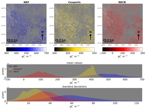
Quantification of carbon fluxes of crops is an essential building block for the construction of a monitoring, reporting, and verification approach. We developed an end-to-end platform (AgriCarbon-EO) that assimilates, through a Bayesian approach, high-resolution (10 m) optical remote sensing data into radiative transfer and crop modelling at regional scale (100 x 100 km). Large-scale estimates of carbon flux are validated against in situ flux towers and yield maps and analysed at regional scale.
Chiara Corbari, Nicola Paciolla, Giada Restuccia, and Ahmad Al Bitar
Nat. Hazards Earth Syst. Sci. Discuss., https://doi.org/10.5194/nhess-2022-260, https://doi.org/10.5194/nhess-2022-260, 2022
Preprint withdrawn
Short summary
Short summary
We developed an EO-based agricultural drought index (ADMOS) for irrigation management. ADMOS identifies drought levels using rainfall, soil moisture, surface temperature and vegetation anomalies from multiple satellite data. ADMOS was tested in two Italian areas, diverse in climate, crop and irrigation. In one, ADMOS and irrigation volumes were negatively correlated; while in the other, no correlation was found, because the same irrigation is applied every year.

Roiya Souissi, Mehrez Zribi, Chiara Corbari, Marco Mancini, Sekhar Muddu, Sat Kumar Tomer, Deepti B. Upadhyaya, and Ahmad Al Bitar
Hydrol. Earth Syst. Sci., 26, 3263–3297, https://doi.org/10.5194/hess-26-3263-2022, https://doi.org/10.5194/hess-26-3263-2022, 2022
Short summary
Short summary
In this study, we investigate the combination of surface soil moisture information with process-related features, namely, evaporation efficiency, soil water index and normalized difference vegetation index, using artificial neural networks to predict root-zone soil moisture. The joint use of process-related features yielded more accurate predictions in the case of arid and semiarid conditions. However, they have no to little added value in temperate to tropical conditions.
Rémi Madelon, K. Arthur Endsley, John S. Kimball, Gabriëlle J. M. De Lannoy, Oliver Sonnentag, Haley Alcock, Alex Mavrovic, Scott N. Williamson, Vincent Maire, Arnaud Mialon, and Alexandre Roy
Biogeosciences, 23, 6359–6407, https://doi.org/10.5194/bg-23-6359-2026, https://doi.org/10.5194/bg-23-6359-2026, 2026
Short summary
Short summary
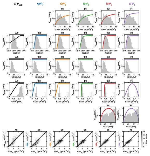
This study aims to improve estimates of carbon dioxide release and uptake in the North American Arctic and subarctic regions. Several modeling approaches were tested, showing that a better representation of sunlight and temperature effects on ecosystems leads to improved estimates. This work provides new perspectives to better assess whether these regions act as sources or sinks of greenhouse gases and how they may influence the climate system by amplifying or slowing global warming.
Manu Holmberg, Mike Schwank, Andreas Colliander, Juliette Ortet, Juha Lemmetyinen, Yiwen Zhou, Philippe Richaume, Cristina Vittucci, Kimmo Rautiainen, Arnaud Mialon, and Yann Kerr
EGUsphere, https://doi.org/10.5194/egusphere-2026-2927, https://doi.org/10.5194/egusphere-2026-2927, 2026
This preprint is open for discussion and under review for Geoscientific Model Development (GMD).
Short summary
Short summary
Satellites measuring long-wavelength microwaves provide essential information on soil moisture, frozen ground, snow, and forests, which matter for climate and weather. Turning these measurements into useful information requires physical models of how the land surface emits microwaves. This paper presents and tests one such model using data from two satellites and three field sites. The results clarify the model's assumptions, show where it works, and identify the main sources of uncertainty.
Amen Al-Yaari, Chris Smith, Yi Yao, Kjetil S. Aas, L. Ruby Leung, Min-Hui Lo, Sonali McDermid, Larissa Nazarenko, Yadu Pokhrel, Yusuke Satoh, Tokuta Yokohata, and Wim Thiery
EGUsphere, https://doi.org/10.5194/egusphere-2026-4199, https://doi.org/10.5194/egusphere-2026-4199, 2026
Short summary
Short summary
In this study, we use the Irrigation Model Intercomparison Project (IRRMIP) to provide the first multi-model quantification of irrigation-induced effective radiative forcing (ERF) across seven Earth system models over 1902–2014. We find that the global multi-model mean ERF is positive but small (~0.023 W m⁻²). This small global signal masks regional heterogeneity: South Asia and West Central Asia show higher positive ERF (~0.25 W m⁻²), while East Asia shows a negative signal (−0.03 W m⁻²).
Yann Baehr, Pierre Vanderbecken, Bertrand Bonan, Catherine Robert, Mathieu Regimbeau, François Pimont, Kevyn Raynal, Xiangzhuo Liu, Remi Savazzi, Moncef Garouani, Josiane Mothe, Nemesio Rodriguez-Fernandez, Lionel Jarlan, and Jean-Christophe Calvet
EGUsphere, https://doi.org/10.5194/egusphere-2026-1247, https://doi.org/10.5194/egusphere-2026-1247, 2026
This preprint is open for discussion and under review for Natural Hazards and Earth System Sciences (NHESS).
Short summary
Short summary
This study produced vegetation water content maps to help manage the risk of forest fires in France. Artificial intelligence was used alongside land surface model outputs, satellite data and in situ observations to monitor vegetation stress in real time. The methodology tested has been shown to be robust and spatially consistent.
Kimmo Rautiainen, Manu Holmberg, Juval Cohen, Arnaud Mialon, Mike Schwank, Juha Lemmetyinen, Antonio de la Fuente, and Yann Kerr
Earth Syst. Sci. Data, 17, 5337–5353, https://doi.org/10.5194/essd-17-5337-2025, https://doi.org/10.5194/essd-17-5337-2025, 2025
Short summary
Short summary
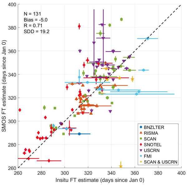
The SMOS (Soil Moisture and Ocean Salinity) Soil Freeze–Thaw State product uses satellite data to monitor seasonal soil freezing and thawing globally, with a focus on high-latitude regions. This is important for understanding greenhouse gas emissions, as frozen soil is associated with methane release. The product provides accurate data on key events such as the first day of soil freezing in autumn, helping scientists to study climate change, ecosystem dynamics, and its impact on our planet.
Juliette Ortet, Arnaud Mialon, Alain Royer, Mike Schwank, Manu Holmberg, Kimmo Rautiainen, Simone Bircher-Adrot, Andreas Colliander, Yann Kerr, and Alexandre Roy
The Cryosphere, 19, 3571–3598, https://doi.org/10.5194/tc-19-3571-2025, https://doi.org/10.5194/tc-19-3571-2025, 2025
Short summary
Short summary
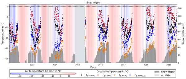
We propose a new method to determine the ground surface temperature under the snowpack in the Arctic area from satellite observations. The obtained ground temperature time series were evaluated over 21 reference sites in Northern Alaska and compared with ground temperatures obtained with global models. The method is extremely promising for monitoring ground temperature below the snowpack and studying the spatio-temporal variability thanks to 15 years of observations over the whole Arctic area.
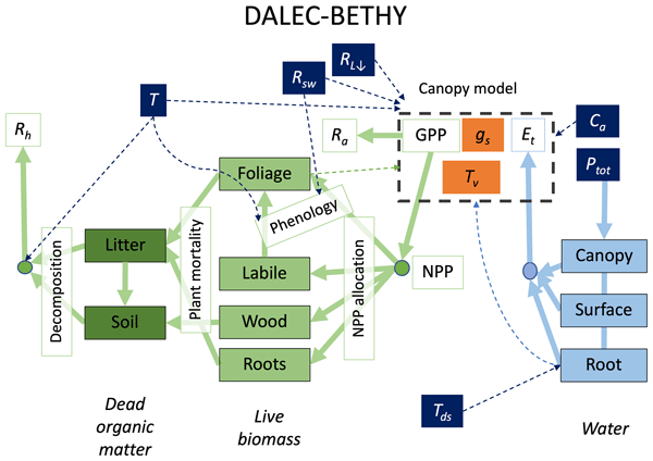
Wolfgang Knorr, Matthew Williams, Tea Thum, Thomas Kaminski, Michael Voßbeck, Marko Scholze, Tristan Quaife, T. Luke Smallman, Susan C. Steele-Dunne, Mariette Vreugdenhil, Tim Green, Sönke Zaehle, Mika Aurela, Alexandre Bouvet, Emanuel Bueechi, Wouter Dorigo, Tarek S. El-Madany, Mirco Migliavacca, Marika Honkanen, Yann H. Kerr, Anna Kontu, Juha Lemmetyinen, Hannakaisa Lindqvist, Arnaud Mialon, Tuuli Miinalainen, Gaétan Pique, Amanda Ojasalo, Shaun Quegan, Peter J. Rayner, Pablo Reyes-Muñoz, Nemesio Rodríguez-Fernández, Mike Schwank, Jochem Verrelst, Songyan Zhu, Dirk Schüttemeyer, and Matthias Drusch
Geosci. Model Dev., 18, 2137–2159, https://doi.org/10.5194/gmd-18-2137-2025, https://doi.org/10.5194/gmd-18-2137-2025, 2025
Short summary
Short summary
When it comes to climate change, the land surface is where the vast majority of impacts happen. The task of monitoring those impacts across the globe is formidable and must necessarily rely on satellites – at a significant cost: the measurements are only indirect and require comprehensive physical understanding. We have created a comprehensive modelling system that we offer to the research community to explore how satellite data can be better exploited to help us capture the changes that happen on our lands.
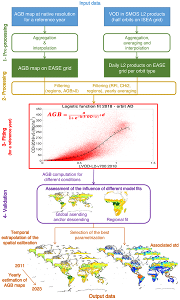
Simon Boitard, Arnaud Mialon, Stéphane Mermoz, Nemesio J. Rodríguez-Fernández, Philippe Richaume, Julio César Salazar-Neira, Stéphane Tarot, and Yann H. Kerr
Earth Syst. Sci. Data, 17, 1101–1119, https://doi.org/10.5194/essd-17-1101-2025, https://doi.org/10.5194/essd-17-1101-2025, 2025
Short summary
Short summary
Aboveground biomass (AGB) is a critical component of the Earth's carbon cycle. The presented dataset aims to help monitor this essential climate variable with AGB time series from 2011 onward, derived with a carefully calibrated spatial relationship between the measurements of the Soil Moisture and Ocean Salinity (SMOS) mission and pre-existing AGB maps. The produced dataset has been extensively compared with other available AGB time series and can be used in AGB studies.
Taeken Wijmer, Ahmad Al Bitar, Ludovic Arnaud, Remy Fieuzal, and Eric Ceschia
Geosci. Model Dev., 17, 997–1021, https://doi.org/10.5194/gmd-17-997-2024, https://doi.org/10.5194/gmd-17-997-2024, 2024
Short summary
Short summary
Quantification of carbon fluxes of crops is an essential building block for the construction of a monitoring, reporting, and verification approach. We developed an end-to-end platform (AgriCarbon-EO) that assimilates, through a Bayesian approach, high-resolution (10 m) optical remote sensing data into radiative transfer and crop modelling at regional scale (100 x 100 km). Large-scale estimates of carbon flux are validated against in situ flux towers and yield maps and analysed at regional scale.
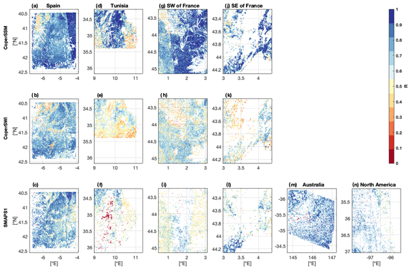
Remi Madelon, Nemesio J. Rodríguez-Fernández, Hassan Bazzi, Nicolas Baghdadi, Clement Albergel, Wouter Dorigo, and Mehrez Zribi
Hydrol. Earth Syst. Sci., 27, 1221–1242, https://doi.org/10.5194/hess-27-1221-2023, https://doi.org/10.5194/hess-27-1221-2023, 2023
Short summary
Short summary
We present an approach to estimate soil moisture (SM) at 1 km resolution using Sentinel-1 and Sentinel-3 satellites. The estimates were compared to other high-resolution (HR) datasets over Europe, northern Africa, Australia, and North America, showing good agreement. However, the discrepancies between the different HR datasets and their lower performances compared with in situ measurements and coarse-resolution datasets show the remaining challenges for large-scale HR SM mapping.
Chiara Corbari, Nicola Paciolla, Giada Restuccia, and Ahmad Al Bitar
Nat. Hazards Earth Syst. Sci. Discuss., https://doi.org/10.5194/nhess-2022-260, https://doi.org/10.5194/nhess-2022-260, 2022
Preprint withdrawn
Short summary
Short summary
We developed an EO-based agricultural drought index (ADMOS) for irrigation management. ADMOS identifies drought levels using rainfall, soil moisture, surface temperature and vegetation anomalies from multiple satellite data. ADMOS was tested in two Italian areas, diverse in climate, crop and irrigation. In one, ADMOS and irrigation volumes were negatively correlated; while in the other, no correlation was found, because the same irrigation is applied every year.
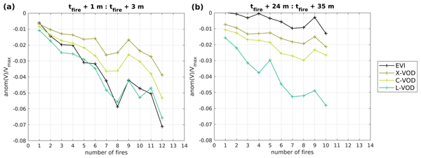
Emma Bousquet, Arnaud Mialon, Nemesio Rodriguez-Fernandez, Stéphane Mermoz, and Yann Kerr
Biogeosciences, 19, 3317–3336, https://doi.org/10.5194/bg-19-3317-2022, https://doi.org/10.5194/bg-19-3317-2022, 2022
Short summary
Short summary
Pre- and post-fire values of four climate variables and four vegetation variables were analysed at the global scale, in order to observe (i) the general fire likelihood factors and (ii) the vegetation recovery trends over various biomes. The main result of this study is that L-band vegetation optical depth (L-VOD) is the most impacted vegetation variable and takes the longest to recover over dense forests. L-VOD could then be useful for post-fire vegetation recovery studies.
Roiya Souissi, Mehrez Zribi, Chiara Corbari, Marco Mancini, Sekhar Muddu, Sat Kumar Tomer, Deepti B. Upadhyaya, and Ahmad Al Bitar
Hydrol. Earth Syst. Sci., 26, 3263–3297, https://doi.org/10.5194/hess-26-3263-2022, https://doi.org/10.5194/hess-26-3263-2022, 2022
Short summary
Short summary
In this study, we investigate the combination of surface soil moisture information with process-related features, namely, evaporation efficiency, soil water index and normalized difference vegetation index, using artificial neural networks to predict root-zone soil moisture. The joint use of process-related features yielded more accurate predictions in the case of arid and semiarid conditions. However, they have no to little added value in temperate to tropical conditions.
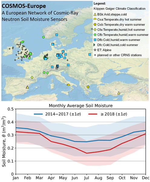
Heye Reemt Bogena, Martin Schrön, Jannis Jakobi, Patrizia Ney, Steffen Zacharias, Mie Andreasen, Roland Baatz, David Boorman, Mustafa Berk Duygu, Miguel Angel Eguibar-Galán, Benjamin Fersch, Till Franke, Josie Geris, María González Sanchis, Yann Kerr, Tobias Korf, Zalalem Mengistu, Arnaud Mialon, Paolo Nasta, Jerzy Nitychoruk, Vassilios Pisinaras, Daniel Rasche, Rafael Rosolem, Hami Said, Paul Schattan, Marek Zreda, Stefan Achleitner, Eduardo Albentosa-Hernández, Zuhal Akyürek, Theresa Blume, Antonio del Campo, Davide Canone, Katya Dimitrova-Petrova, John G. Evans, Stefano Ferraris, Félix Frances, Davide Gisolo, Andreas Güntner, Frank Herrmann, Joost Iwema, Karsten H. Jensen, Harald Kunstmann, Antonio Lidón, Majken Caroline Looms, Sascha Oswald, Andreas Panagopoulos, Amol Patil, Daniel Power, Corinna Rebmann, Nunzio Romano, Lena Scheiffele, Sonia Seneviratne, Georg Weltin, and Harry Vereecken
Earth Syst. Sci. Data, 14, 1125–1151, https://doi.org/10.5194/essd-14-1125-2022, https://doi.org/10.5194/essd-14-1125-2022, 2022
Short summary
Short summary
Monitoring of increasingly frequent droughts is a prerequisite for climate adaptation strategies. This data paper presents long-term soil moisture measurements recorded by 66 cosmic-ray neutron sensors (CRNS) operated by 24 institutions and distributed across major climate zones in Europe. Data processing followed harmonized protocols and state-of-the-art methods to generate consistent and comparable soil moisture products and to facilitate continental-scale analysis of hydrological extremes.
Cited articles
Al Bitar, A., Leroux, D. J., Kerr, Y. H., Merlin, O., Richaume, P., Sahoo, A., and Wood, E. F.: Evaluation of SMOS Soil Moisture Products Over Continental U.S. Using the SCAN/SNOTEL Network, IEEE T. Geosci. Remote, 50, 1572–1586, 2012.
Al-Yaari, A., Wigneron, J. P., Ducharne, A., Kerr, Y., de Rosnay, P., de Jeu, R., Govind, A., Al Bitar, A., Albergel, C., Muñoz-Sabater, J., Richaume, P., and Mialon, A.: Global-scale evaluation of two satellite-based passive microwave soil moisture datasets (SMOS and AMSR-E) with respect to Land Data Assimilation System estimates, Remote Sens. Environ., 149, 181–195, 2014a.
Al-Yaari, A., Wigneron, J. P., Ducharne, A., Kerr, Y. H., Wagner, W., De Lannoy, G., Reichle, R., Al Bitar, A., Dorigo, W., Richaume, P., and Mialon, A.: Global-scale comparison of passive (SMOS) and active (ASCAT) satellite based microwave soil moisture retrievals with soil moisture simulations (MERRA-Land), Remote Sens. Environ., 152, 614–626, 2014b.
AMMA-CATCH: Rivers flow and water electrical conductivity, Oueme meso site, Benin, IRD, CNRS-INSU, OSUG, OMP, OREME, https://doi.org/10.5072/AMMA-CATCH.CL.Run_O, 1996.
AMMA-CATCH: Surface energy, water vapor, and carbon fluxes, Wankama local site, Niger, IRD, CNRS-INSU, OSUG, OMP, OREME. https://doi.org/10.5072/AMMA-CATCH.AE.H2OFlux_Ncw, 2005.
Brocca, L., Melone, F., Moramarco, T., Wagner, W., Naeimi, V., Bartalis, Z., and Hasenauer, S.: Improving runoff prediction through the assimilation of the ASCAT soil moisture product, Hydrol. Earth Syst. Sci., 14, 1881–1893, https://doi.org/10.5194/hess-14-1881-2010, 2010.
Brodzik, M. J. and Knowles, K. W.: EASE-Grid: A Versatile Set of Equal-Area Projections and Grids, in: Discrete Global Grids, edited by: Goodchild, M. and Kimerling, A. J., National Center for Geographic Information & Analysis, Santa Barbara, California USA, 2002.
Cappelaere, B., Descroix, L., Lebel, T., Boulain, N., Ramier, D., Laurent, J.-P., Favreau, G., Boubkraoui, S., Boucher, M., Moussa, I. B., Chaffard, V., Hiernaux, P., Issoufou, H. B. A., Le Breton, E., Mamadou, I., Nazoumou, Y., Oï, M., Ottlé, C., and Quantin, G.: The AMMA-CATCH experiment in the cultivated Sahelian area of south-west Niger – Investigating water cycle response to a fluctuating climate and changing environment, J. Hydrol., 375, 34–51, 2009.
Carr, D. B., Kahn, R., Sahr, K., and Olsen, T.: ISEA Discrete Global Grids, Statistical Computing & Statistical Graphics Newsletter, 8, 31–39, 1997.
Cox, D. R. and Oakes, D.: Analysis of Survival Data, Chapman & Hall, London, UK, 1984.
de Rosnay, P., Gruhier, C., Timouk, F., Baup, F., Mougin, E., Hiernaux, P., Kergoat, L., and LeDantec, V.: Multiscale soil moisture measurements at the Gourma meso-scale site in Mali, J. Hydrol., 375, 241–252, 2009.
de Rosnay, P., Drusch, M., Vasiljevic, D., Balsamo, G., Albergel, C., and Isaksen, L.: A simplified Extended Kalman Filter for the global operational soil moisture analysis at ECMWF, Q. J. Roy. Meteor. Soc., 139, 1199–1213, 2013.
Drusch, M.: Initializing numerical weather prediction models with satellite-derived surface soil moisture: Data assimilation experiments with ECMWF's integrated forecast system and the TMI soil moisture data set, J. Geophys. Res., 112, D03102, https://doi.org/10.1029/2006JD007478, 2007.
Elliott, R. L., Schiebe, F. R., Crawford, K. C., Peter, K. D., and Puckett, W. E.: A Unique Data Capability for Natural Resources Studies, International Winter Meeting; American Society of Agricultural Engineers, Chicago, IL, 14–17 December 1993, ASAE Paper No. 932529, 1993.
Entekhabi, D., Njoku, E. G., O'Neill, P. E., Kellogg, K. H., Crow, W. T., Edelstein, W. N., Entin, J. K., Goodman, S. D., Jackson, T. J., Johnson, J., Kimball, J., Piepmeier, J. R., Koster, R. D., Martin, N., McDonald, K. C., Moghaddam, M., Moran, S., Reichle, R., Shi, J. C., Spencer, M. W., Thurman, S. W., Tsang, L., and Zyl, J. V.: The Soil Moisture Active Passive (SMAP) Mission, Proceedings of the IEEE, 98, 704–716, 2010.
Escorihuela, M. J., Chanzy, A., Wigneron, J. P., and Kerr, Y. H.: Effective soil moisture sampling depth of L-band radiometry: A case study, Remote Sens. Environ., 114, 995–1001, 2010.
Guérif, M. and Duke, C. L.: Adjustment procedures of a crop model to the site specific characteristics of soil and crop using remote sensing data assimilation, Agr. Ecosyst. Environ., 81, 57–69, https://doi.org/10.1016/S0167-8809(00)00168-7, 2000.
Hagolle, O., Dedieu, G., Mougenot, B., Debaecker, V., Duchemin, B., and Meygret, A.: Correction of aerosol effects on multi-temporal images acquired with constant viewing angles: Application to Formosat-2 images, Remote Sens. Environ., 112, 1689–1701, 2008.
Hagolle, O., Huc, M., Pascual, D. V., Dedieu, G.: A multi-temporal method for cloud detection, applied to FORMOSAT-2, VENμS, LANDSAT and SENTINEL-2 images, Remote Sens. Environ., 114, 1747–1755, 2010.
Hagolle, O., Huc, M., Villa Pascual, D., and Dedieu, G.: A Multi-Temporal and Multi-Spectral Method to Estimate Aerosol Optical Thickness over Land, for the Atmospheric Correction of FormoSat-2, LandSat, VENμS and Sentinel-2 Images, Remote Sensing, 7, 2668–2691, 2015.
Hollmann, R., Merchant, C. J., Saunders, R., Downy, C., Buchwitz, M., Cazenave, A., Chuvieco, E., Defourny, P., de Leeuw, G., Forsberg, R., Holzer-Popp, T., Paul, F., Sandven, S., Sathyendranath, S., van Roozendael, M., and Wagner, W.: The ESA climate change initiative: Satellite data records for essential climate variables, B. Am. Meteorol. Soc., 94, 1541–1552, 2013.
Inglada, J. and Mercier, G.: A new statistical similarity measure for change detection in multitemporal SAR images and its extension to multiscale change analysis, IEEE T. Geosci. Remote, 45, 1432–1445, 2007.
Jackson, T. J. and Schmugge, T. J.: Vegetation effects on the microwave emission of soils, Remote Sens. Environ., 36, 203–212, 1991.
Jackson, T. J., Cosh, M. H., Bindlish, R., Starks, P. J., Bosch, D. D., Seyfried, M., Goodrich, D. C., Moran, M. S., and Du, J.: Validation of Advanced Microwave Scanning Radiometer soil moisture products, IEEE T. Geosci. Remote, 48, 4256–4272, 2010.
Jackson, T. J., Bindlish, R., Cosh, M., Zhao, T., Starks, P., Bosch, D., Seyfried, M., Moran, M. S., Goodrich, D., Kerr, Y. H., and Leroux, D.: Validation of Soil Moisture and Ocean Salinity (SMOS) Soil Moisture Over Watershed Networks in the U.S., IEEE T. Geosci. Remote, 50, 1530–1543, 2012.
Jung, M., Reichstein, M., Ciais, P., Seneviratne, S. I., Sheffield, J., Goulden, M. L., Bonan, G., Cescatti, A., Chen, J., de Jeu, R., Dolman, A. J., Eugster, W., Gerten, D., Gianelle, D., Gobron, N., Heinke, J., Kimball, J., Law, B. E., Montagnani, L., Mu, Q., Mueller, B., Oleson, K., Papale, D., Richardson, A. D., Roupsard, O., Running, S., Tomelleri, E., Viovy, N., Weber, U., Williams, C., Wood, E., Zaehle, S., and Zhang, K.: Recent decline in the global land evapotranspiration trend due to limited moisture supply, Nature, 467, 951–954, 2010.
Keefer, T. O., Moran, M. S., and Paige, G. B.: Long-term meteorological and soil hydrology database, Walnut Gulch Experimental Watershed, Arizona, United States, Water Resour. Res., 44, W05S07, https://doi.org/10.1029/2006WR005702, 2008.
Kerr, Y. H. and Njoku, E. G.: Semiempirical model for interpreting microwave emission from semiarid land surfaces as seen from space, IEEE T. Geosci. Remote, 28, 384–393, https://doi.org/10.1109/36.54364, 1990.
Kerr, Y. H., Waldteufel, P., Wigneron, J.-P., Martinuzzi, J. M., Font, J., and Berger, M.: Soil moisture retrieval from space: The Soil Moisture and Ocean Salinity (SMOS) mission, IEEE T. Geosci. Remote, 39, 1729–1735, https://doi.org/10.1109/36.942551, 2001.
Kerr, Y. H., Waldteufel, P., Wigneron, J.-P., Delwart, S., Cabot, F., Boutin, J., Escorihuela, M. J., Font, J., Reul, N., Gruhier, C., Juglea, S. E., Drinkwater, M. R., Hahne, A., Martin-Neira, M., and Mecklenburg, S.: The SMOS Mission: New Tool for Monitoring Key Elements of the Global Water Cycle, Proceedings of the IEEE, 98, 666–687, https://doi.org/10.1109/JPROC.2010.2043032, 2010.
Kerr, Y. H., Waldteufel, P., Richaume, P., Wigneron, J.-P., Ferrazzoli, P., Mahmoodi, A., Al Bitar, A., Cabot, F., Gruhier, C., Enache Juglea, S., Leroux, D., Mialon, A., and Delwart, S.: The SMOS Soil Moisture Retrieval Algorithm, IEEE T. Geosci. Remote, 50, 1384–1403, 2012.
Kerr, Y. H., Jacquette, E., Al Bitar, A., Cabot, F., Mialon, A., and Richaume, P.: CATDS SMOS L3 soil moisture retrieval processor, Algorithm Theoretical Baseline Document (ATBD), CATDS, 73 pp., 2013.
Keyantash, J. and Dracup, J. A.: The quantification of drought: an evaluation of drought indices, B. Am. Meteorol. Soc., 83, 1167–1180, 2002.
Khazâal, A., Anterrieu, E., Cabot, F., and Kerr, Y. H.: Impact of Direct Solar Radiations Seen by the Back-Lobes Antenna Patterns of SMOS on the Retrieved Images, IEEE J. Sel. Top. Appl., PP, 1–8, https://doi.org/10.1109/JSTARS.2016.2609601, 2016.
Klein, L. A. and Swift, C. T.: An Improved Model for the Dielectric Constant of Sea Water at Microwave Frequencies, IEEE J. Oceanic Eng., 2, 104–111, 1977.
Konings, A. G., Piles, M., Rötzer, K., McColl, K. A., Chan, S. K., and Entekhabi, D.: Vegetation optical depth and scattering albedo retrieval using time series of dual-polarized L-band radiometer observations, Remote Sens. Environ., 172, 178–189, 2016.
Koster, R. D., Dirmeyer, P. A., Guo, Z., Bonan, G., Chan, E., Cox, P., Gordon, C. T., Kanae, S., Kowalczyk, E., Lawrence, D., Liu, P., Lu, C.-H., Malyshev, S., McAvaney, B., Mitchell, K., Mocko, D., Oki, T., Oleson, K., Pitman, A., Sud, Y. C., Taylor, C. M., Verseghy, D., Vasic, R., Xue, Y., and Yamada, T.: Regions of strong coupling between soil moisture and precipitation, Science, 305, 1138–1140, 2004.
Leroux, D. J., Kerr, Y. H., Al Bitar, A., Bindlish, R., Jackson, T., Berthelot, B., and Portet, G.: Comparison Between SMOS, VUA, ASCAT, and ECMWF Soil Moisture Products Over Four Watersheds in U.S., IEEE T. Geosci. Remote, 52, 1562–1571, 2014.
Lievens, H., Tomer, S. K., Al Bitar, A., De Lannoy, G. J. M., Drusch, M., Dumedah, G., Franssen, H. J. H., Kerr, Y. H., Martens, B., Pan, M., and Roundy, J. K.: SMOS soil moisture assimilation for improved hydrologic simulation in the Murray Darling Basin, Australia, Remote Sens. Environ., 168, 146–162, 2015.
Liu, S. F., Liou, Y.-A., Wang, W. J., Wigneron, J.-P., and Lee, J. B.: Retrieval of crop biomass and soil moisture from measured 1.4 and 10.65 brightness temperatures, IEEE T. Geosci. Remote, 40, 1260–1268, 2002.
Louvet, S., Pellarin, T., Al Bitar, A., Cappelaere, B., Galle, S., Grippa, M., Gruhier, C., Kerr, Y., Lebel, T., Mialon, A., Mougin, E., Quantin, G., Richaume, P., and de Rosnay, P.: SMOS soil moisture product evaluation over West-Africa from local to regional scale, Remote Sens. Environ., 156, 383–394, https://doi.org/10.1016/j.rse.2014.10.005, 2015.
Masson, V., Champeaux, J.-L., Chauvin, F., Meriguet, C., and Lacaze, R.: A Global Database of Land Surface Parameters at 1-km Resolution in Meteorological and Climate Models, J. Climate, 16, 1261–1282, 2003.
Mattia, F., Satalino, G., Pauwels, V. R. N., and Loew, A.: Soil moisture retrieval through a merging of multi-temporal L-band SAR data and hydrologic modelling, Hydrol. Earth Syst. Sci., 13, 343–356, https://doi.org/10.5194/hess-13-343-2009, 2009.
Mialon, A., Richaume, P., Leroux, D., Bircher, S., Al Bitar, A., Pellarin, T., Wigneron, J.-P., and Kerr, Y. H.: Comparison of Dobson and Mironov dielectric models in the SMOS soil moisture retrieval algorithm, IEEE T. Geosci. Remote, 53, 3084–3094, 2015.
Miernecki, M., Wigneron, J. P., Lopez-Baeza, E., Kerr, Y., De Jeu, R., De Lannoy, G. J., Jackson, T. J., O'Neill, P. E., Schwank, M., Fernandez Moran, R., Bircher, S., Lawrence, H., Mialon, A., Al Bitar, A., and Richaume, P.: Comparison of SMOS and SMAP soil moisture retrieval approaches using tower-based radiometer data over a vineyard field, Remote Sens. Environ., 154, 89–101, 2014.
Mo, T., Choudhury, B. J., Schmugge, T. J., Wang, J. R., and Jackson, T. J.: A model for microwave emission from vegetation-covered fields, J. Geophys. Res., 87, 11229–11237, 1982.
Mougin, E., Hiernaux, P., Kergoat, L., Grippa, M., de Rosnay, P., Timouk, F., Le Dantec, V., Demarez, V., Lavenu, F., Arjounin, M., Lebel, T., Soumaguel, N., Ceschia, E., Mougenot, B., Baup, F., Frappart, F., Frison, P. L., Gardelle, J., Gruhier, C., Jarlan, L., Mangiarotti, S., Sanou, B., Tracol, Y., Guichard, F., Trichon, V., Diarra, L., Soumaré, A., Koité, M., Dembélé, F., Lloyd, C., Hanan, N. P., Damesin, C., Delon, C., Serça, D., Galy-Lacaux, C., Seghieri, J., Becerra, S., Dia, H., Gangneron, F., and Mazzega, P.: The AMMA-CATCH Gourma observatory site in Mali: Relating climatic variations to changes in vegetation, surface hydrology, fluxes and natural resources, J. Hydrol., 375, 14–33, 2009.
Naeimi, V., Scipal, K., Bartalis, Z., Hasenauer, S., and Wagner, W.: An improved soil moisture retrieval algorithm for ERS and METOP scatterometer observations, IEEE T. Geosci. Remote, 47, 1999–2013, 2009.
Njoku, E. G. and Entekhabi, D.: Passive microwave remote sensing of soil moisture, J. Hydrol., 184, 101–129, https://doi.org/10.1016/0022-1694(95)02970-2, 1996.
Njoku, E. G., Jackson, T. J., Lakshmi, V., Chan, T. K., and Nghiem, S. V.: Soil moisture retrieval from AMSR-E, IEEE T. Geosci Remote, 41, 215–229, 2003.
O'Neill, P. E., Chan, S., Njoku, E. G., Jackson, T. J., and Bindlish, R.: Soil Moisture Active Passive (SMAP), Algorithm Theoretical Basis Document, SMAP L2 & L3 Radar Soil Moisture (Active) Data Products, Revision B, Jet Propulsion Laboratory, California Institute of Technology, Pasadena, CA, 2015.
O'Neill, P. E., Chan, S., Njoku, E. G., Jackson, T., and Bindlish, R.: SMAP L3 Radiometer Global Daily 36 km EASE-Grid Soil Moisture, Version 4, NASA National Snow and Ice Data Center Distributed Active Archive Center, Boulder, Colorado, USA, https://doi.org/10.5067/OBBHQ5W22HME, 2016.
Oliva, R., Daganzo-Eusebio, E., Kerr, Y. H., Mecklenburg, S., Nieto, S., Richaume, P., and Gruhier, C.: SMOS Radio Frequency Interference Scenario: Status and Actions Taken to Improve the RFI Environment in the 1400–1427-MHz Passive Band, IEEE T. Geosci. Remote, 50, 1427–1439, https://doi.org/10.1109/TGRS.2012.2182775, 2012.
Owe, M., de Jeu, R., and Holmes, T.: Multisensor historical climatology of satellite-derived global land surface moisture, J. Geophys. Res., 113, F01002, https://doi.org/10.1029/2007JF000769, 2008.
Pellarin, T., Laurent, J. P., Cappelaere, B., Decharme, B., Descroix, L., and Ramier, D.: Hydrological modelling and associated microwave emission of a semi-arid region in South-western Niger, J. Hydrol., 375, 262–272, 2009.
Rahmoune, R., Ferrazzoli, P., Singh, Y. K., Kerr, Y. H., Richaume, P., and Al Bitar, A.: SMOS Retrieval Results Over Forests: Comparisons With Independent Measurements, IEEE J. Sel. Top. Appl., 7, 3858–3866, 2014.
Richaume, P., Soldo, Y., Anterrieu, E., Khazaal, A., Bircher, S., Mialon, A., Al Bitar, A., Rodriguez-Fernandez, N., Cabot, F., Kerr, Y., and Mahmoodi, A.: RFI in SMOS measurements: Update on detection, localization, mitigation techniques and preliminary quantified impacts on soil moisture products, Geoscience and Remote Sensing Symposium (IGARSS), 2014 IEEE International, 13–18 July 2014, Quebec City, QC, Canada, 223–226, https://doi.org/10.1109/IGARSS.2014.6946397, 2014.
Rodríguez-Fernández, N. J., Aires, F., Richaume, P., Kerr, Y. H., Prigent, C., Kolassa, J., Cabot, F., Mahmoodir, A., Jimenez, J. C., and Drusch, M.: Soil moisture retrieval using neural networks: application to SMOS, IEEE T. Geosci. Remote Sens., 53, 5991–6007, 2015.
Sahoo A. K., Houser, P. R., Ferguson, C., Wood, E. F., Dirmeyer, P. A., and Kafatos, M.: Evaluation of AMSR-E soil moisture results using the insitu data over the Little River Experimental Watershed, Georgia, Remote Sens. Environ., 112, 3142–3152, 2008.
Saleh, K., Wigneron, J.-P., De Rosnay, P., Calvet, J.-C., and Kerr, Y.: Semi-empirical regressions at L-band applied to surface soil moisture retrievals over grass, Remote Sens. Environ., 101, 415–426, 2006.
Soldo, Y., Khazaal, A., Cabot, F., Richaume, P., Anterrieu, E., and Kerr, Y. H.: Mitigation of RFIs for SMOS: A distributed approach, IEEE T. Geosci. Remote, 52, 7470–7479, 2014.
Tomer, S. K., Al Bitar, A., Sekhar, M., Zribi, M., Bandyopadhyay, S., Sreelash, K., Sharma, A. K., Corgne, S., and Kerr, Y.: Retrieval and Multi-scale Validation of Soil Moisture from Multi-temporal SAR Data in a Semi-Arid Tropical Region, Remote Sensing, 7, 8128–8153, 2015.
Ulaby, F. T., Dubois, P. C., and van Zyl, J.: Radar mapping of surface soil moisture, J. Hydrol., 184, 57–84, https://doi.org/10.1016/0022-1694(95)02968-0, 1996.
Verhoest, N. E., Troch, P. A., Paniconi, C., and De Troch, F. P.: Mapping basin scale variable source areas from multitemporal remotely sensed observations of soil moisture behavior, Water Resour. Res., 34, 3235–3244, 1998.
Wagner, W., Lemoine, G., and Rott, H.: A Method for Estimating Soil Moisture from ERS Scatterometer and Soil Data, Remote Sens. Environ., 70, 191–207, 1999.
Wagner, W., Hahn, S., Kidd, R., Melzer, T., Bartalis, Z., Hasenauer, S., Figa, J., de Rosnay, P., Jann, A., Schneider, S., Komma, J., Kubu, G., Brugger, K., Aubrecht, C., Zuger, J., Gangkofner, U., Kienberger, S., Brocca, L., Wang, Y., Bloeschl, G., Eitzinger, J., Steinnocher, K., Zeil, P., and Rubel, F.: The ASCAT Soil Moisture Product: A Review of its Specifications, Validation Results, and Emerging Applications, Meteorol. Z., 22, 5–33, 2013.
Wigneron, J.-P., Calvet, J.-C., de Rosnay, P., Kerr, Y., Waldteufel, P., Saleh, K., Escorihuela, M. J., and Kruszewski, A.: Soil moisture retrievals from bi-angular L-band passivemicrowave observations, IEEE T. Geosci. Remote S., 1, 277–281, 2004.
Wigneron, J.-P., Kerr, Y. H., Waldteufel, P., Saleh, K., Escorihuela, M.-J., Richaume, P., Ferrazzoli, P., de Rosnay, P., Gurneye, R., Calvet, J.-C., Grant, J. P., Guglielmettih, M., Hornbuckle, B., Mätzler, C., Pellarin, T., and Schwank, M.: L-band Microwave Emission of the Biosphere (L-MEB) Model: Description and calibration against experimental data sets over crop fields, Remote Sens. Environ., 107, 639–655, https://doi.org/10.1016/j.rse.2006.10.014, 2007.
Wigneron, J.-P., Jackson, T. J., O'Neill, P., De Lannoy, G., de Rosnay, P., Walker, J. P., Ferrazzoli, P., Mironov, V., Bircher, S., Grant, J. P., Kurum, M., Schwank, M., Munoz-Sabater, J., Das, N., Royer, A., Al-Yaari, A., Al Bitar, A., Fernandez-Moran, R., Lawrence, H., Mialon, A., Parrens, M., Richaume, P., Delwart, S., and Kerr, Y.: Modelling the passive microwave signature from land surfaces: A review of recent results and application to the L-band SMOS & SMAP soil moisture retrieval algorithms, Remote Sens. Environ., 192, 238–262, 2017.
Short summary
Surface soil moisture is a control variable for many processes linked to the water and carbon cycles. The global maps of soil moisture and brightness temperature using multiple orbits from the SMOS (Soil Moisture and Ocean Salinity) mission are presented in this paper. The maps showed an increased number of retrievals over forest areas (9 %) compared to single-orbit retrievals. The brightness temperature observations from the L-band missions SMOS (ESA) and SMAP (NASA) are close (bias < −4 K).
Surface soil moisture is a control variable for many processes linked to the water and carbon...


Altmetrics
Final-revised paper
Preprint