Articles | Volume 18, issue 10
https://doi.org/10.5194/essd-18-7535-2026
© Author(s) 2026. This work is distributed under
the Creative Commons Attribution 4.0 License.
the Creative Commons Attribution 4.0 License.
https://doi.org/10.5194/essd-18-7535-2026
© Author(s) 2026. This work is distributed under
the Creative Commons Attribution 4.0 License.
the Creative Commons Attribution 4.0 License.
Data description article
| Highlight paper
| 
15 Oct 2026
Data description article | Highlight paper |
| 15 Oct 2026
| 15 Oct 2026
Tracking recent extremes and interannual variability of global fire emissions using a near-real-time extension to the Global Fire Emissions Database

Department of Earth System Science, University of California, Irvine, 92612, USA
Guido R. van der Werf
Meteorology and Air Quality Group, Wageningen University & Research, Wageningen, the Netherlands
Mingquan Mu
Department of Earth System Science, University of California, Irvine, 92612, USA
Dave van Wees
BeZero Carbon, London, UK
Joanne V. Hall
Department of Geographical Sciences, University of Maryland, College Park, MD, USA
Louis Giglio
Department of Geographical Sciences, University of Maryland, College Park, MD, USA
Roland Vernooij
Meteorology and Air Quality Group, Wageningen University & Research, Wageningen, the Netherlands
Douglas C. Morton
Biospheric Sciences Laboratory, NASA Goddard Space Flight Center, Greenbelt, MD, USA
Li Xu
Department of Earth System Science, University of California, Irvine, 92612, USA
Tianjia Liu
Department of Geography, University of British Columbia, Vancouver, BC, Canada
Rebecca C. Scholten
Department of Earth System Science, University of California, Irvine, 92612, USA
Shane R. Coffield
Earth System Science Interdisciplinary Center, University of Maryland, College Park, MD, USA
Melanie B. Follette-Cook
Biospheric Sciences Laboratory, NASA Goddard Space Flight Center, Greenbelt, MD, USA
Lesley Ott
Biospheric Sciences Laboratory, NASA Goddard Space Flight Center, Greenbelt, MD, USA
James T. Randerson
Department of Earth System Science, University of California, Irvine, 92612, USA
Related authors
Li Xu, Qi Tang, Qing Zhu, William J. Riley, Guido R. van der Werf, Yang Chen, Michael J. Prather, and James T. Randerson
EGUsphere, https://doi.org/10.5194/egusphere-2026-4288, https://doi.org/10.5194/egusphere-2026-4288, 2026
This preprint is open for discussion and under review for Atmospheric Chemistry and Physics (ACP).
Short summary
Short summary
Using the E3SM version 3 model with interactive chemistry, this study shows that wildfires substantially perturb global and regional tropospheric chemistry and modify radiative effects through aerosol and ozone interactions, with particularly strong impacts in tropical fire regions. By connecting wildfire emissions with changes in atmospheric composition, radiation, and climate, this study provides important insights on how the atmosphere responds to changing fire activities.
Ye Liu, Huilin Huang, Sing-Chun Wang, Tao Zhang, Donghui Xu, and Yang Chen
Geosci. Model Dev., 18, 4103–4117, https://doi.org/10.5194/gmd-18-4103-2025, https://doi.org/10.5194/gmd-18-4103-2025, 2025
Short summary
Short summary
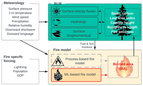
This study integrates machine learning with a land surface model to improve wildfire predictions in North America. Traditional models struggle with accurately simulating burned areas due to simplified processes. By combining the predictive power of machine learning with a land model, our hybrid framework better captures fire dynamics. This approach enhances our understanding of wildfire behavior and aids in developing more effective climate and fire management strategies.
Tianjia Liu, James T. Randerson, Yang Chen, Douglas C. Morton, Elizabeth B. Wiggins, Padhraic Smyth, Efi Foufoula-Georgiou, Roy Nadler, and Omer Nevo
Earth Syst. Sci. Data, 16, 1395–1424, https://doi.org/10.5194/essd-16-1395-2024, https://doi.org/10.5194/essd-16-1395-2024, 2024
Short summary
Short summary
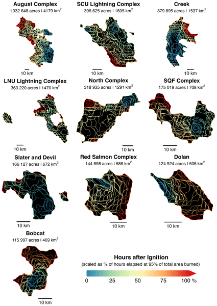
To improve our understanding of extreme wildfire behavior, we use geostationary satellite data to develop the GOFER algorithm and track the hourly fire progression of large wildfires. GOFER fills a key temporal gap present in other fire tracking products that rely on low-Earth-orbit imagery and reveals considerable variability in fire spread rates on diurnal timescales. We create a product of hourly fire perimeters, active-fire lines, and fire spread rates for 28 fires in California.
Joanne V. Hall, Fernanda Argueta, Maria Zubkova, Yang Chen, James T. Randerson, and Louis Giglio
Earth Syst. Sci. Data, 16, 867–885, https://doi.org/10.5194/essd-16-867-2024, https://doi.org/10.5194/essd-16-867-2024, 2024
Short summary
Short summary
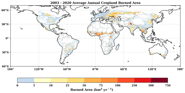
Crop-residue burning is a widespread practice often occurring close to population centers. Its recurrent nature requires accurate mapping of the area burned – a key input into air quality models. Unlike larger fires, crop fires require a specific burned area (BA) methodology, which to date has been ignored in global BA datasets. Our global cropland-focused BA product found a significant increase in global cropland BA (81 Mha annual average) compared to the widely used MCD64A1 (32 Mha).
Yang Chen, Joanne Hall, Dave van Wees, Niels Andela, Stijn Hantson, Louis Giglio, Guido R. van der Werf, Douglas C. Morton, and James T. Randerson
Earth Syst. Sci. Data, 15, 5227–5259, https://doi.org/10.5194/essd-15-5227-2023, https://doi.org/10.5194/essd-15-5227-2023, 2023
Short summary
Short summary
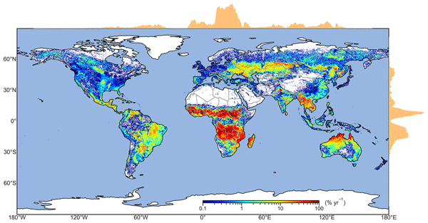
Using multiple sets of remotely sensed data, we created a dataset of monthly global burned area from 1997 to 2020. The estimated annual global burned area is 774 million hectares, significantly higher than previous estimates. Burned area declined by 1.21% per year due to extensive fire loss in savanna, grassland, and cropland ecosystems. This study enhances our understanding of the impact of fire on the carbon cycle and climate system, and may improve the predictions of future fire changes.
Vivek K. Arora, Chris D. Jones, Pierre Friedlingstein, Tatiana Ilyina, Guilherme L. Torres Mendonça, Benjamin Sanderson, Charles Koven, Heather Graven, Michio Kawamiya, Victor Brovkin, John Dunne, Forrest M. Hoffman, Julia Pongratz, James T. Randerson, Anastasia Romanou, Sönke Zaehle, and Kirsten Zickfeld
EGUsphere, https://doi.org/10.5194/egusphere-2026-5533, https://doi.org/10.5194/egusphere-2026-5533, 2026
This preprint is open for discussion and under review for Geoscientific Model Development (GMD).
Short summary
Short summary
Earth system models (ESM) are important tools for understanding how the Earth’s climate and carbon cycle interact, and how Earth system responds to anthropogenic CO2 emissions. The Coupled Climate-Carbon Cycle Model Intercomparison Project (C4MIP) compares Earth system models from around the world in context of climate and carbon cycle interactions. This manuscript describes the new set of experiments for C4MIP for the seventh phase of the coupled modelling intercomparison project (CMIP7).
Danni Zhang, Bo Zheng, Biqing Zhu, Yidi Xu, Xinrui Liu, Naixian Wang, Longyi Zhang, Jiarui Liang, Guido R. van der Werf, Philippe Ciais, and Thomas Gasser
EGUsphere, https://doi.org/10.5194/egusphere-2026-5536, https://doi.org/10.5194/egusphere-2026-5536, 2026
This preprint is open for discussion and under review for Geoscientific Model Development (GMD).
Short summary
Short summary
Here we present OSCAR-fire v1.0, a wildfire carbon dynamics module developed within the OSCAR compact Earth system model. The module extends OSCAR's land carbon bookkeeping framework and describes how a fire event induces instantaneous combustion carbon emissions, legacy dead carbon release, and gradual post-fire ecosystem recovery. This is a process-based and computationally efficient module that can be used for quantifying wildfire contributions to the land carbon budget.
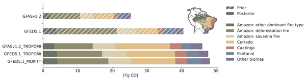
Anne-Wil van den Berg, Joram J. D. Hooghiem, Auke M. van der Woude, Pieter Rijsdijk, Roland Vernooij, Santiago Botía, Guido R. van der Werf, John B. Miller, Ingrid T. Luijkx, Maarten C. Krol, and Wouter Peters
Atmos. Chem. Phys., 26, 13929–13958, https://doi.org/10.5194/acp-26-13929-2026, https://doi.org/10.5194/acp-26-13929-2026, 2026
Short summary
Short summary
We estimate 2019 Brazilian fire carbon monoxide (CO) emissions using CO retrievals from multiple satellites in a new top-down inversion framework. The retrievals strongly constrain fire emissions and complement existing inventories. National-scale posterior emissions align well with the new Global Fire Emissions Database v5.1, supporting progress in fire emission models. Yet, posterior emissions in the Cerrado and Caatinga are systematically higher than inventories; we discuss potential drivers.
Kai-Ting Hu, Jonathan A. Wang, Xiaoran Zhu, Wanwan Liang, Douglas C. Morton, Jinhyuk Kim, James Randerson, and Mark A. Friedl
EGUsphere, https://doi.org/10.5194/egusphere-2026-4090, https://doi.org/10.5194/egusphere-2026-4090, 2026
This preprint is open for discussion and under review for Earth Observation (EO).
Short summary
Short summary
Forests across Canada and Alaska are changing as the climate warms and wildfires grow more intense, but how much and where has been unclear. Using satellite images spanning 35 years, we found that nearly 11 percent of Canada and Alaska changed in land cover between 1986 and 2020. Evergreen forests shrank while deciduous trees and shrubs spread, especially after fires. These shifts are reshaping vast northern landscapes and could influence the wider climate for decades to come.
Li Xu, Qi Tang, Qing Zhu, William J. Riley, Guido R. van der Werf, Yang Chen, Michael J. Prather, and James T. Randerson
EGUsphere, https://doi.org/10.5194/egusphere-2026-4288, https://doi.org/10.5194/egusphere-2026-4288, 2026
This preprint is open for discussion and under review for Atmospheric Chemistry and Physics (ACP).
Short summary
Short summary
Using the E3SM version 3 model with interactive chemistry, this study shows that wildfires substantially perturb global and regional tropospheric chemistry and modify radiative effects through aerosol and ozone interactions, with particularly strong impacts in tropical fire regions. By connecting wildfire emissions with changes in atmospheric composition, radiation, and climate, this study provides important insights on how the atmosphere responds to changing fire activities.
Lurui Niu, Xiaomei Xu, Elizabeth Wiggins, James Randerson, Allison Welch, Guaciara Santos, Rebecca Sheesley, Claire Moffett, and Claudia Czimczik
EGUsphere, https://doi.org/10.5194/egusphere-2026-3338, https://doi.org/10.5194/egusphere-2026-3338, 2026
This preprint is open for discussion and under review for Atmospheric Chemistry and Physics (ACP).
Short summary
Short summary
The Athabasca oil sands are a major source of PM2.5 from mining, upgrading, and diesel fleets. Summer emissions mix with wildfire smoke and boreal biogenic aerosols, complicating source attribution. We measured PM2.5 isotopes at Fort McKay in 2017 and found fossil fuel combustion dominated smoke-free periods, while biomass burning dominated smoke events. A persistent fossil carbon signature distinguished the region from remote Arctic and boreal sites.
Chantelle Burton, Francesca Di Giuseppe, Matthew W. Jones, Douglas I. Kelley, Maria L. F. Barbosa, Joe McNorton, Robert Potts, Carlota Segura-Garcia, John T. Abatzoglou, Iulian Alin Rosu, Niels Andela, Liana O. Anderson, Sally Archibald, Esther Brambleby, Emilio Chuvieco, Andy Ciavarella, Hamish Clarke, Francisco de la Barrera, Carlos M. Di Bella, Enza Di Tomaso, Kebonye Dintwe, Tim S. Doherty, Victoria M. Donovan, Jonathan M. Eden, Paulo M. Fernandes, Lukas Fiedler, Louis Giglio, Olivia Haas, Douglas Hamilton, Stijn Hantson, Sarah Harris, Andrew J. Hartley, Theodore R. Keeping, Crystal A. Kolden, Jean-Luc Kouassi, Elena Kukavskaya, Seppe Lampe, Zhongwei Liu, Guilherme Mataveli, Sarah Meier, Duarte Oom, Mark Parrington, Yuquan Qu, Victor Resco de Dios, Julien Ruffault, Mojtaba Sadegh, Cristina Santín, Fernando Sedano, Jacquelyn K. Shuman, Patrícia S. Silva, Fiona R. Spuler, Carmen B. Steinmann, Veerachai Tanpipat, Miguel Ángel Torres-Vazquez, Marco Turco, Guido R. van der Werf, Dave van Wees, Sander Veraverbeke, Jakob B. Wessel, and Bo Zheng
Earth Syst. Sci. Data Discuss., https://doi.org/10.5194/essd-2026-587, https://doi.org/10.5194/essd-2026-587, 2026
Revised manuscript under review for ESSD
Short summary
Short summary
The third State of Wildfires report examines extreme wildfire events from 2025 to early 2026. It analyses key regional events in Midwestern Canadian Shield Forests, Northwest Iberia, and Chilean Temperate Forests and Matorral, assessing their impacts, drivers, and attributing them to climate change. Climate change greatly increased the likelihood of these fires, and without strong mitigation, such events will become more frequent.
Tianjia Liu, Kento Otobe, and Makoto Kelp
Int. Arch. Photogramm. Remote Sens. Spatial Inf. Sci., XLIX-B3-2026, 987–993, https://doi.org/10.5194/isprs-archives-XLIX-B3-2026-987-2026, https://doi.org/10.5194/isprs-archives-XLIX-B3-2026-987-2026, 2026
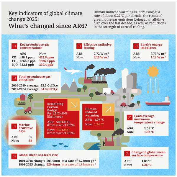
Piers M. Forster, Tristram Walsh, Chris Smith, William F. Lamb, Robin Lamboll, Christophe Cassou, Mathias Hauser, Zeke Hausfather, June-Yi Lee, Matthew D. Palmer, Karina von Schuckmann, Aimée B. A. Slangen, Sophie Szopa, Blair Trewin, Jeongeun Yun, Nathan P. Gillett, Stuart Jenkins, H. Damon Matthews, Krishnan Raghavan, Aurélien Ribes, Joeri Rogelj, Debbie Rosen, Xuebin Zhang, Myles Allen, Robbie M. Andrew, Chris Atkinson, Richard A. Betts, Antonio Bombelli, Samantha N. Burgess, Lijing Cheng, Helen E. Claxton, Pierre Friedlingstein, Thomas L. Frölicher, Catia M. Domingues, Thomas Gasser, Catherine H. Gregory, Rachel M. Hoesly, Daniel Huppmann, Masayoshi Ishii, Christopher Kadow, Alexia Karwat, John Kennedy, Rachel E. Killick, Mahesh V. M. Kovilakam, Paul B. Krummel, Xin Lan, Jean-François Lamarque, Aurélien Liné, Belén Martín-Míguez, Didier P. Monselesan, Colin Morice, Jens Mühle, Pino Mussak, Glen P. Peters, Anna Pirani, Julia Pongratz, Matthew Rigby, Robert Rohde, Abhishek Savita, Sonia I. Seneviratne, Steven J. Smith, Ghassan Taha, Caterina Tassone, Peter Thorne, Christopher Wells, Luke M. Western, Guido R. van der Werf, Susan E. Wijffels, Marco Zecchetto, Junting Zhong, Xiao-Ye Zhang, Valérie Masson-Delmotte, and Panmao Zhai
Earth Syst. Sci. Data, 18, 3889–3933, https://doi.org/10.5194/essd-18-3889-2026, https://doi.org/10.5194/essd-18-3889-2026, 2026
Short summary
Short summary
We give our annual update of key climate indicators. Our work quantifies the human contribution to global warming and the pace of climate change. This represents a large effort by the international community akin to an Intergovernmental Panel on Climate Change (IPCC) report.
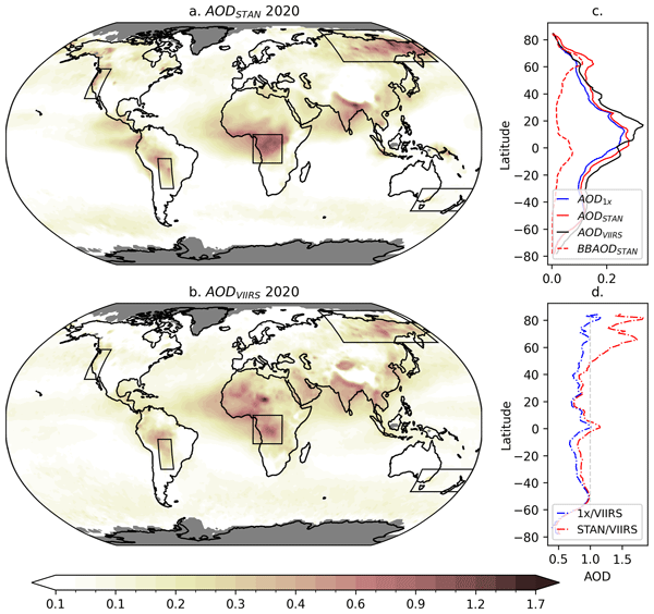
Elizabeth Quaye, Ben T. Johnson, James M. Haywood, Guido R. van der Werf, Roland Vernooij, Stephen A. Sitch, and Tom Eames
Atmos. Chem. Phys., 26, 6629–6654, https://doi.org/10.5194/acp-26-6629-2026, https://doi.org/10.5194/acp-26-6629-2026, 2026
Short summary
Short summary
We find aerosol optical depths in a global climate model are overestimated during extreme wildfire events if emissions are scaled up by a factor of two, typically applied to improve simulated aerosol on seasonal–annual timescales. We propose a technique where a variable scaling factor is determined by fuel consumption, improving correlation in five fire-affected areas. We explore the impact of this change on aerosol radiative effects, during extreme events and on broader space and time scales.
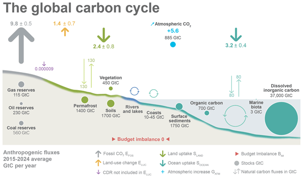
Pierre Friedlingstein, Michael O'Sullivan, Matthew W. Jones, Robbie M. Andrew, Dorothee C. E. Bakker, Judith Hauck, Peter Landschützer, Corinne Le Quéré, Hongmei Li, Ingrid T. Luijkx, Glen P. Peters, Wouter Peters, Julia Pongratz, Clemens Schwingshackl, Stephen Sitch, Josep G. Canadell, Philippe Ciais, Kjetil Aas, Simone R. Alin, Peter Anthoni, Leticia Barbero, Nicholas R. Bates, Nicolas Bellouin, Alice Benoit-Cattin, Carla F. Berghoff, Raffaele Bernardello, Laurent Bopp, Ida Bagus Mandhara Brasika, Matthew A. Chamberlain, Naveen Chandra, Frédéric Chevallier, Louise P. Chini, Nathan O. Collier, Thomas H. Colligan, Margot Cronin, Laique M. Djeutchouang, Xinyu Dou, Matt P. Enright, Kazutaka Enyo, Michael Erb, Wiley Evans, Richard A. Feely, Liang Feng, Daniel J. Ford, Adrianna Foster, Filippa Fransner, Thomas Gasser, Marion Gehlen, Thanos Gkritzalis, Jefferson Goncalves De Souza, Giacomo Grassi, Luke Gregor, Nicolas Gruber, Bertrand Guenet, Özgür Gürses, Kirsty Harrington, Ian Harris, Jens Heinke, George C. Hurtt, Yosuke Iida, Tatiana Ilyina, Akihiko Ito, Andrew R. Jacobson, Atul K. Jain, Tereza Jarníková, Annika Jersild, Fei Jiang, Steve D. Jones, Etsushi Kato, Ralph F. Keeling, Kees Klein Goldewijk, Jürgen Knauer, Yawen Kong, Jan Ivar Korsbakken, Charles Koven, Taro Kunimitsu, Xin Lan, Junjie Liu, Zhiqiang Liu, Zhu Liu, Claire Lo Monaco, Lei Ma, Gregg Marland, Patrick C. McGuire, Galen A. McKinley, Joe R. Melton, Natalie Monacci, Erwan Monier, Eric J. Morgan, David R. Munro, Jens D. Müller, Shin-Ichiro Nakaoka, Lorna R. Nayagam, Yosuke Niwa, Tobias Nutzel, Are Olsen, Abdirahman M. Omar, Naiqing Pan, Sudhanshu Pandey, Denis Pierrot, Zhangcai Qin, Pierre Regnier, Gregor Rehder, Laure Resplandy, Alizée Roobaert, Thais M. Rosan, Christian Rödenbeck, Jörg Schwinger, Ingunn Skjelvan, T. Luke Smallman, Victoria Spada, Mohanan G. Sreeush, Qing Sun, Adrienne J. Sutton, Colm Sweeney, Didier Swingedouw, Roland Séférian, Shintaro Takao, Hiroaki Tatebe, Hanqin Tian, Xiangjun Tian, Bronte Tilbrook, Hiroyuki Tsujino, Francesco Tubiello, Erik van Ooijen, Guido R. van der Werf, Sebastiaan J. van de Velde, Anthony P. Walker, Rik Wanninkhof, Xiaojuan Yang, Wenping Yuan, Xu Yue, and Jiye Zeng
Earth Syst. Sci. Data, 18, 3211–3288, https://doi.org/10.5194/essd-18-3211-2026, https://doi.org/10.5194/essd-18-3211-2026, 2026
Short summary
Short summary
The Global Carbon Budget 2025 describes the methodology, main results, and datasets used to quantify the anthropogenic emissions of carbon dioxide (CO2) and their partitioning among the atmosphere, land ecosystems, and the ocean over the historical period (1750–2025). These living datasets are updated every year to provide the highest transparency and traceability in the reporting of CO2, the key driver of climate change.
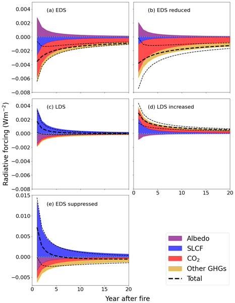
Tom Eames, Nick Schutgens, Eleftherios Ioannidis, Ivar R. van der Velde, Max J. van Gerrevink, Roland Vernooij, and Guido R. van der Werf
Atmos. Chem. Phys., 25, 17429–17453, https://doi.org/10.5194/acp-25-17429-2025, https://doi.org/10.5194/acp-25-17429-2025, 2025
Short summary
Short summary
Prescribed burning is used as a landscape management tool in southern African savannas. By deliberately changing the timing of fires in this region, the climate effect (radiative forcing) of a fire season can be altered. We show that by burning earlier in the dry season a small climate cooling effect can be achieved, similar to that of a 10 % reduction in global commercial aviation emissions. Local effects must be considered before implementing a fire regime shift for climate change mitigation.
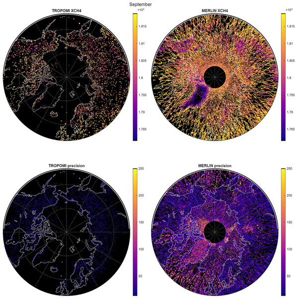
Martijn M. T. A. Pallandt, Abhishek Chatterjee, Lesley E. Ott, Julia Marshall, and Mathias Göckede
Atmos. Meas. Tech., 18, 7053–7073, https://doi.org/10.5194/amt-18-7053-2025, https://doi.org/10.5194/amt-18-7053-2025, 2025
Short summary
Short summary
Climate change is greatly affecting the Arctic. Among these changes is the thawing of permanently frozen soil, which may increase the release of methane, a powerful greenhouse gas (GHG). In this study we investigated the capabilities of tall GHG measuring towers and two satellite systems to detect this methane release. We find that these systems have different strengths and weaknesses, and that individually they struggle to detect these changes, though combined they might cover their weak spots.
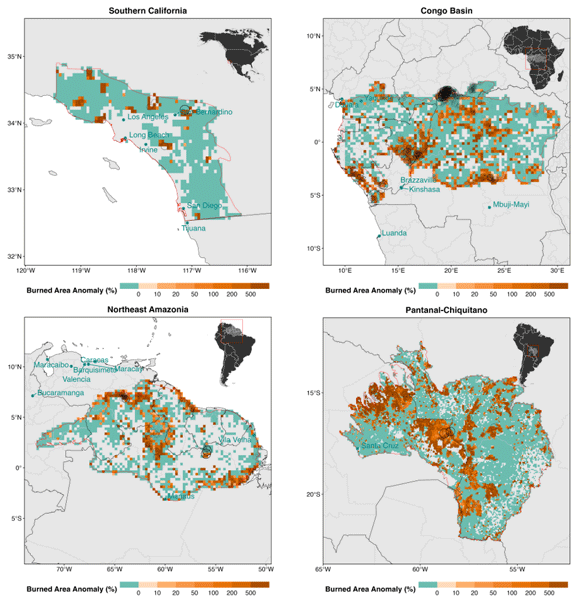
Douglas I. Kelley, Chantelle Burton, Francesca Di Giuseppe, Matthew W. Jones, Maria L. F. Barbosa, Esther Brambleby, Joe R. McNorton, Zhongwei Liu, Anna S. I. Bradley, Katie Blackford, Eleanor Burke, Andrew Ciavarella, Enza Di Tomaso, Jonathan Eden, Igor José M. Ferreira, Lukas Fiedler, Andrew J. Hartley, Theodore R. Keeping, Seppe Lampe, Anna Lombardi, Guilherme Mataveli, Yuquan Qu, Patrícia S. Silva, Fiona R. Spuler, Carmen B. Steinmann, Miguel Ángel Torres-Vázquez, Renata Veiga, Dave van Wees, Jakob B. Wessel, Emily Wright, Bibiana Bilbao, Mathieu Bourbonnais, Cong Gao, Carlos M. Di Bella, Kebonye Dintwe, Victoria M. Donovan, Sarah Harris, Elena A. Kukavskaya, Aya Brigitte N'Dri, Cristina Santín, Galia Selaya, Johan Sjöström, John T. Abatzoglou, Niels Andela, Rachel Carmenta, Emilio Chuvieco, Louis Giglio, Douglas S. Hamilton, Stijn Hantson, Sarah Meier, Mark Parrington, Mojtaba Sadegh, Jesus San-Miguel-Ayanz, Fernando Sedano, Marco Turco, Guido R. van der Werf, Sander Veraverbeke, Liana O. Anderson, Hamish Clarke, Paulo M. Fernandes, and Crystal A. Kolden
Earth Syst. Sci. Data, 17, 5377–5488, https://doi.org/10.5194/essd-17-5377-2025, https://doi.org/10.5194/essd-17-5377-2025, 2025
Short summary
Short summary
The second State of Wildfires report examines extreme wildfire events from 2024 to early 2025. It analyses key regional events in Southern California, Northeast Amazonia, Pantanal–Chiquitano, and the Congo Basin, assessing their drivers and predictability and attributing them to climate change and land use. Seasonal outlooks and decadal projections are provided. Climate change greatly increased the likelihood of these fires, and without strong mitigation, such events will become more frequent.
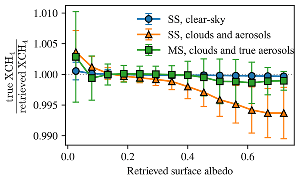
Peter Somkuti, Gregory McGarragh, Christopher O'Dell, Antonio Di Noia, Leif Vogel, Sean Crowell, Lesley E. Ott, and Hartmut Bösch
Atmos. Meas. Tech., 18, 4647–4663, https://doi.org/10.5194/amt-18-4647-2025, https://doi.org/10.5194/amt-18-4647-2025, 2025
Short summary
Short summary
In space-based estimates of atmospheric methane concentrations, one can often observe biases that look like imprints of surface features. We performed realistic simulation experiments and find the root cause to be unaccounted aerosols. Since good knowledge of aerosols is difficult to achieve for operational science data processing, we conclude that a comprehensive surface bias correction scheme is highly important for missions utilizing the 2.3 µm spectral band for methane retrievals.
Zhixuan Guo, Wei Li, Philippe Ciais, Stephen Sitch, Guido R. van der Werf, Simon P. K. Bowring, Ana Bastos, Florent Mouillot, Jiaying He, Minxuan Sun, Lei Zhu, Xiaomeng Du, Nan Wang, and Xiaomeng Huang
Earth Syst. Sci. Data, 17, 3599–3618, https://doi.org/10.5194/essd-17-3599-2025, https://doi.org/10.5194/essd-17-3599-2025, 2025
Short summary
Short summary
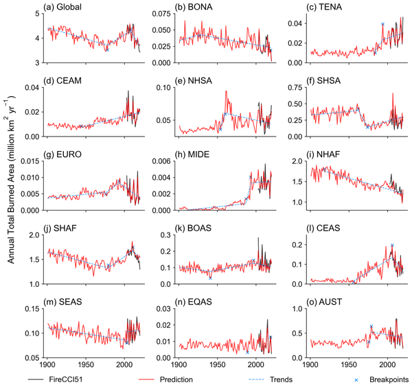
To address the limitations of short time spans in satellite data and spatiotemporal discontinuity in site records, we reconstructed global monthly burned area maps at a 0.5° resolution for 1901–2020 using machine learning models. The global burned area is predicted at 3.46 × 10⁶–4.58 × 10⁶ km² per year, showing a decline from 1901 to 1978, an increase from 1978 to 2008 and a sharper decrease from 2008 to 2020. This dataset provides a benchmark for studies on fire ecology and the carbon cycle.
Ye Liu, Huilin Huang, Sing-Chun Wang, Tao Zhang, Donghui Xu, and Yang Chen
Geosci. Model Dev., 18, 4103–4117, https://doi.org/10.5194/gmd-18-4103-2025, https://doi.org/10.5194/gmd-18-4103-2025, 2025
Short summary
Short summary
This study integrates machine learning with a land surface model to improve wildfire predictions in North America. Traditional models struggle with accurately simulating burned areas due to simplified processes. By combining the predictive power of machine learning with a land model, our hybrid framework better captures fire dynamics. This approach enhances our understanding of wildfire behavior and aids in developing more effective climate and fire management strategies.
Piers M. Forster, Chris Smith, Tristram Walsh, William F. Lamb, Robin Lamboll, Christophe Cassou, Mathias Hauser, Zeke Hausfather, June-Yi Lee, Matthew D. Palmer, Karina von Schuckmann, Aimée B. A. Slangen, Sophie Szopa, Blair Trewin, Jeongeun Yun, Nathan P. Gillett, Stuart Jenkins, H. Damon Matthews, Krishnan Raghavan, Aurélien Ribes, Joeri Rogelj, Debbie Rosen, Xuebin Zhang, Myles Allen, Lara Aleluia Reis, Robbie M. Andrew, Richard A. Betts, Alex Borger, Jiddu A. Broersma, Samantha N. Burgess, Lijing Cheng, Pierre Friedlingstein, Catia M. Domingues, Marco Gambarini, Thomas Gasser, Johannes Gütschow, Masayoshi Ishii, Christopher Kadow, John Kennedy, Rachel E. Killick, Paul B. Krummel, Aurélien Liné, Didier P. Monselesan, Colin Morice, Jens Mühle, Vaishali Naik, Glen P. Peters, Anna Pirani, Julia Pongratz, Jan C. Minx, Matthew Rigby, Robert Rohde, Abhishek Savita, Sonia I. Seneviratne, Peter Thorne, Christopher Wells, Luke M. Western, Guido R. van der Werf, Susan E. Wijffels, Valérie Masson-Delmotte, and Panmao Zhai
Earth Syst. Sci. Data, 17, 2641–2680, https://doi.org/10.5194/essd-17-2641-2025, https://doi.org/10.5194/essd-17-2641-2025, 2025
Short summary
Short summary
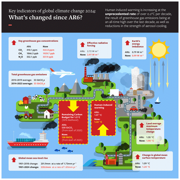
In a rapidly changing climate, evidence-based decision-making benefits from up-to-date and timely information. Here we compile monitoring datasets to track real-world changes over time. To make our work relevant to policymakers, we follow methods from the Intergovernmental Panel on Climate Change (IPCC). Human activities are increasing the Earth's energy imbalance and driving faster sea-level rise compared to the IPCC assessment.
Cynthia H. Whaley, Tim Butler, Jose A. Adame, Rupal Ambulkar, Steve R. Arnold, Rebecca R. Buchholz, Benjamin Gaubert, Douglas S. Hamilton, Min Huang, Hayley Hung, Johannes W. Kaiser, Jacek W. Kaminski, Christoph Knote, Gerbrand Koren, Jean-Luc Kouassi, Meiyun Lin, Tianjia Liu, Jianmin Ma, Kasemsan Manomaiphiboon, Elisa Bergas Masso, Jessica L. McCarty, Mariano Mertens, Mark Parrington, Helene Peiro, Pallavi Saxena, Saurabh Sonwani, Vanisa Surapipith, Damaris Y. T. Tan, Wenfu Tang, Veerachai Tanpipat, Kostas Tsigaridis, Christine Wiedinmyer, Oliver Wild, Yuanyu Xie, and Paquita Zuidema
Geosci. Model Dev., 18, 3265–3309, https://doi.org/10.5194/gmd-18-3265-2025, https://doi.org/10.5194/gmd-18-3265-2025, 2025
Short summary
Short summary
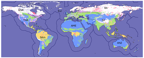
The multi-model experiment design of the HTAP3 Fires project takes a multi-pollutant approach to improving our understanding of transboundary transport of wildland fire and agricultural burning emissions and their impacts. The experiments are designed with the goal of answering science policy questions related to fires. The options for the multi-model approach, including inputs, outputs, and model setup, are discussed, and the official recommendations for the project are presented.
Pierre Friedlingstein, Michael O'Sullivan, Matthew W. Jones, Robbie M. Andrew, Judith Hauck, Peter Landschützer, Corinne Le Quéré, Hongmei Li, Ingrid T. Luijkx, Are Olsen, Glen P. Peters, Wouter Peters, Julia Pongratz, Clemens Schwingshackl, Stephen Sitch, Josep G. Canadell, Philippe Ciais, Robert B. Jackson, Simone R. Alin, Almut Arneth, Vivek Arora, Nicholas R. Bates, Meike Becker, Nicolas Bellouin, Carla F. Berghoff, Henry C. Bittig, Laurent Bopp, Patricia Cadule, Katie Campbell, Matthew A. Chamberlain, Naveen Chandra, Frédéric Chevallier, Louise P. Chini, Thomas Colligan, Jeanne Decayeux, Laique M. Djeutchouang, Xinyu Dou, Carolina Duran Rojas, Kazutaka Enyo, Wiley Evans, Amanda R. Fay, Richard A. Feely, Daniel J. Ford, Adrianna Foster, Thomas Gasser, Marion Gehlen, Thanos Gkritzalis, Giacomo Grassi, Luke Gregor, Nicolas Gruber, Özgür Gürses, Ian Harris, Matthew Hefner, Jens Heinke, George C. Hurtt, Yosuke Iida, Tatiana Ilyina, Andrew R. Jacobson, Atul K. Jain, Tereza Jarníková, Annika Jersild, Fei Jiang, Zhe Jin, Etsushi Kato, Ralph F. Keeling, Kees Klein Goldewijk, Jürgen Knauer, Jan Ivar Korsbakken, Xin Lan, Siv K. Lauvset, Nathalie Lefèvre, Zhu Liu, Junjie Liu, Lei Ma, Shamil Maksyutov, Gregg Marland, Nicolas Mayot, Patrick C. McGuire, Nicolas Metzl, Natalie M. Monacci, Eric J. Morgan, Shin-Ichiro Nakaoka, Craig Neill, Yosuke Niwa, Tobias Nützel, Lea Olivier, Tsuneo Ono, Paul I. Palmer, Denis Pierrot, Zhangcai Qin, Laure Resplandy, Alizée Roobaert, Thais M. Rosan, Christian Rödenbeck, Jörg Schwinger, T. Luke Smallman, Stephen M. Smith, Reinel Sospedra-Alfonso, Tobias Steinhoff, Qing Sun, Adrienne J. Sutton, Roland Séférian, Shintaro Takao, Hiroaki Tatebe, Hanqin Tian, Bronte Tilbrook, Olivier Torres, Etienne Tourigny, Hiroyuki Tsujino, Francesco Tubiello, Guido van der Werf, Rik Wanninkhof, Xuhui Wang, Dongxu Yang, Xiaojuan Yang, Zhen Yu, Wenping Yuan, Xu Yue, Sönke Zaehle, Ning Zeng, and Jiye Zeng
Earth Syst. Sci. Data, 17, 965–1039, https://doi.org/10.5194/essd-17-965-2025, https://doi.org/10.5194/essd-17-965-2025, 2025
Short summary
Short summary
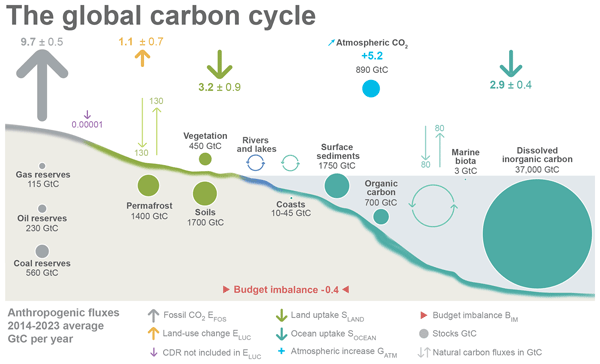
The Global Carbon Budget 2024 describes the methodology, main results, and datasets used to quantify the anthropogenic emissions of carbon dioxide (CO2) and their partitioning among the atmosphere, land ecosystems, and the ocean over the historical period (1750–2024). These living datasets are updated every year to provide the highest transparency and traceability in the reporting of CO2, the key driver of climate change.
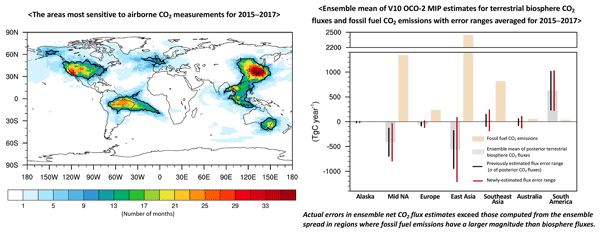
Jeongmin Yun, Junjie Liu, Brendan Byrne, Brad Weir, Lesley E. Ott, Kathryn McKain, Bianca C. Baier, Luciana V. Gatti, and Sebastien C. Biraud
Atmos. Chem. Phys., 25, 1725–1748, https://doi.org/10.5194/acp-25-1725-2025, https://doi.org/10.5194/acp-25-1725-2025, 2025
Short summary
Short summary
This study quantifies errors in regional net surface–atmosphere CO2 flux estimates from an inverse model ensemble using airborne CO2 measurements. Our results show that flux error estimates based on observations significantly exceed those computed from the ensemble spread of flux estimates in regions with high fossil fuel emissions. This finding suggests the presence of systematic biases in the inversion estimates, associated with errors in the fossil fuel emissions common to all models.
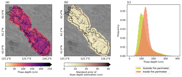
Lucas R. Diaz, Clement J. F. Delcourt, Moritz Langer, Michael M. Loranty, Brendan M. Rogers, Rebecca C. Scholten, Tatiana A. Shestakova, Anna C. Talucci, Jorien E. Vonk, Sonam Wangchuk, and Sander Veraverbeke
Earth Syst. Dynam., 15, 1459–1482, https://doi.org/10.5194/esd-15-1459-2024, https://doi.org/10.5194/esd-15-1459-2024, 2024
Short summary
Short summary
Our study in eastern Siberia investigated how fires affect permafrost thaw depth in larch forests. We found that fire induces deeper thaw, yet this process was mediated by topography and vegetation. By combining field and satellite data, we estimated summer thaw depth across an entire fire scar. This research provides insights into post-fire permafrost dynamics and the use of satellite data for mapping fire-induced permafrost thaw.
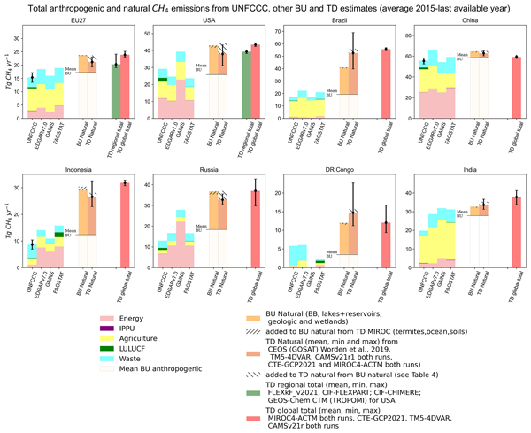
Ana Maria Roxana Petrescu, Glen P. Peters, Richard Engelen, Sander Houweling, Dominik Brunner, Aki Tsuruta, Bradley Matthews, Prabir K. Patra, Dmitry Belikov, Rona L. Thompson, Lena Höglund-Isaksson, Wenxin Zhang, Arjo J. Segers, Giuseppe Etiope, Giancarlo Ciotoli, Philippe Peylin, Frédéric Chevallier, Tuula Aalto, Robbie M. Andrew, David Bastviken, Antoine Berchet, Grégoire Broquet, Giulia Conchedda, Stijn N. C. Dellaert, Hugo Denier van der Gon, Johannes Gütschow, Jean-Matthieu Haussaire, Ronny Lauerwald, Tiina Markkanen, Jacob C. A. van Peet, Isabelle Pison, Pierre Regnier, Espen Solum, Marko Scholze, Maria Tenkanen, Francesco N. Tubiello, Guido R. van der Werf, and John R. Worden
Earth Syst. Sci. Data, 16, 4325–4350, https://doi.org/10.5194/essd-16-4325-2024, https://doi.org/10.5194/essd-16-4325-2024, 2024
Short summary
Short summary
This study provides an overview of data availability from observation- and inventory-based CH4 emission estimates. It systematically compares them and provides recommendations for robust comparisons, aiming to steadily engage more parties in using observational methods to complement their UNFCCC submissions. Anticipating improvements in atmospheric modelling and observations, future developments need to resolve knowledge gaps in both approaches and to better quantify remaining uncertainty.
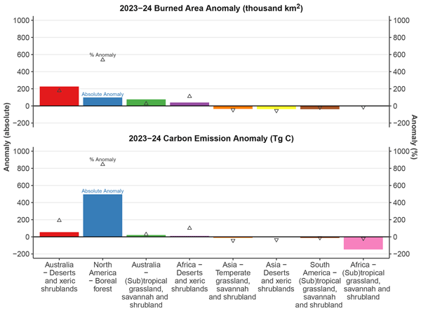
Matthew W. Jones, Douglas I. Kelley, Chantelle A. Burton, Francesca Di Giuseppe, Maria Lucia F. Barbosa, Esther Brambleby, Andrew J. Hartley, Anna Lombardi, Guilherme Mataveli, Joe R. McNorton, Fiona R. Spuler, Jakob B. Wessel, John T. Abatzoglou, Liana O. Anderson, Niels Andela, Sally Archibald, Dolors Armenteras, Eleanor Burke, Rachel Carmenta, Emilio Chuvieco, Hamish Clarke, Stefan H. Doerr, Paulo M. Fernandes, Louis Giglio, Douglas S. Hamilton, Stijn Hantson, Sarah Harris, Piyush Jain, Crystal A. Kolden, Tiina Kurvits, Seppe Lampe, Sarah Meier, Stacey New, Mark Parrington, Morgane M. G. Perron, Yuquan Qu, Natasha S. Ribeiro, Bambang H. Saharjo, Jesus San-Miguel-Ayanz, Jacquelyn K. Shuman, Veerachai Tanpipat, Guido R. van der Werf, Sander Veraverbeke, and Gavriil Xanthopoulos
Earth Syst. Sci. Data, 16, 3601–3685, https://doi.org/10.5194/essd-16-3601-2024, https://doi.org/10.5194/essd-16-3601-2024, 2024
Short summary
Short summary
This inaugural State of Wildfires report catalogues extreme fires of the 2023–2024 fire season. For key events, we analyse their predictability and drivers and attribute them to climate change and land use. We provide a seasonal outlook and decadal projections. Key anomalies occurred in Canada, Greece, and western Amazonia, with other high-impact events catalogued worldwide. Climate change significantly increased the likelihood of extreme fires, and mitigation is required to lessen future risk.

Hanqin Tian, Naiqing Pan, Rona L. Thompson, Josep G. Canadell, Parvadha Suntharalingam, Pierre Regnier, Eric A. Davidson, Michael Prather, Philippe Ciais, Marilena Muntean, Shufen Pan, Wilfried Winiwarter, Sönke Zaehle, Feng Zhou, Robert B. Jackson, Hermann W. Bange, Sarah Berthet, Zihao Bian, Daniele Bianchi, Alexander F. Bouwman, Erik T. Buitenhuis, Geoffrey Dutton, Minpeng Hu, Akihiko Ito, Atul K. Jain, Aurich Jeltsch-Thömmes, Fortunat Joos, Sian Kou-Giesbrecht, Paul B. Krummel, Xin Lan, Angela Landolfi, Ronny Lauerwald, Ya Li, Chaoqun Lu, Taylor Maavara, Manfredi Manizza, Dylan B. Millet, Jens Mühle, Prabir K. Patra, Glen P. Peters, Xiaoyu Qin, Peter Raymond, Laure Resplandy, Judith A. Rosentreter, Hao Shi, Qing Sun, Daniele Tonina, Francesco N. Tubiello, Guido R. van der Werf, Nicolas Vuichard, Junjie Wang, Kelley C. Wells, Luke M. Western, Chris Wilson, Jia Yang, Yuanzhi Yao, Yongfa You, and Qing Zhu
Earth Syst. Sci. Data, 16, 2543–2604, https://doi.org/10.5194/essd-16-2543-2024, https://doi.org/10.5194/essd-16-2543-2024, 2024
Short summary
Short summary
Atmospheric concentrations of nitrous oxide (N2O), a greenhouse gas 273 times more potent than carbon dioxide, have increased by 25 % since the preindustrial period, with the highest observed growth rate in 2020 and 2021. This rapid growth rate has primarily been due to a 40 % increase in anthropogenic emissions since 1980. Observed atmospheric N2O concentrations in recent years have exceeded the worst-case climate scenario, underscoring the importance of reducing anthropogenic N2O emissions.
Piers M. Forster, Chris Smith, Tristram Walsh, William F. Lamb, Robin Lamboll, Bradley Hall, Mathias Hauser, Aurélien Ribes, Debbie Rosen, Nathan P. Gillett, Matthew D. Palmer, Joeri Rogelj, Karina von Schuckmann, Blair Trewin, Myles Allen, Robbie Andrew, Richard A. Betts, Alex Borger, Tim Boyer, Jiddu A. Broersma, Carlo Buontempo, Samantha Burgess, Chiara Cagnazzo, Lijing Cheng, Pierre Friedlingstein, Andrew Gettelman, Johannes Gütschow, Masayoshi Ishii, Stuart Jenkins, Xin Lan, Colin Morice, Jens Mühle, Christopher Kadow, John Kennedy, Rachel E. Killick, Paul B. Krummel, Jan C. Minx, Gunnar Myhre, Vaishali Naik, Glen P. Peters, Anna Pirani, Julia Pongratz, Carl-Friedrich Schleussner, Sonia I. Seneviratne, Sophie Szopa, Peter Thorne, Mahesh V. M. Kovilakam, Elisa Majamäki, Jukka-Pekka Jalkanen, Margreet van Marle, Rachel M. Hoesly, Robert Rohde, Dominik Schumacher, Guido van der Werf, Russell Vose, Kirsten Zickfeld, Xuebin Zhang, Valérie Masson-Delmotte, and Panmao Zhai
Earth Syst. Sci. Data, 16, 2625–2658, https://doi.org/10.5194/essd-16-2625-2024, https://doi.org/10.5194/essd-16-2625-2024, 2024
Short summary
Short summary
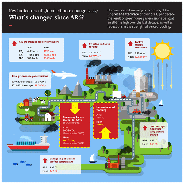
This paper tracks some key indicators of global warming through time, from 1850 through to the end of 2023. It is designed to give an authoritative estimate of global warming to date and its causes. We find that in 2023, global warming reached 1.3 °C and is increasing at over 0.2 °C per decade. This is caused by all-time-high greenhouse gas emissions.
Tianjia Liu, James T. Randerson, Yang Chen, Douglas C. Morton, Elizabeth B. Wiggins, Padhraic Smyth, Efi Foufoula-Georgiou, Roy Nadler, and Omer Nevo
Earth Syst. Sci. Data, 16, 1395–1424, https://doi.org/10.5194/essd-16-1395-2024, https://doi.org/10.5194/essd-16-1395-2024, 2024
Short summary
Short summary
To improve our understanding of extreme wildfire behavior, we use geostationary satellite data to develop the GOFER algorithm and track the hourly fire progression of large wildfires. GOFER fills a key temporal gap present in other fire tracking products that rely on low-Earth-orbit imagery and reveals considerable variability in fire spread rates on diurnal timescales. We create a product of hourly fire perimeters, active-fire lines, and fire spread rates for 28 fires in California.
Joanne V. Hall, Fernanda Argueta, Maria Zubkova, Yang Chen, James T. Randerson, and Louis Giglio
Earth Syst. Sci. Data, 16, 867–885, https://doi.org/10.5194/essd-16-867-2024, https://doi.org/10.5194/essd-16-867-2024, 2024
Short summary
Short summary
Crop-residue burning is a widespread practice often occurring close to population centers. Its recurrent nature requires accurate mapping of the area burned – a key input into air quality models. Unlike larger fires, crop fires require a specific burned area (BA) methodology, which to date has been ignored in global BA datasets. Our global cropland-focused BA product found a significant increase in global cropland BA (81 Mha annual average) compared to the widely used MCD64A1 (32 Mha).
Thomas D. Hessilt, Brendan M. Rogers, Rebecca C. Scholten, Stefano Potter, Thomas A. J. Janssen, and Sander Veraverbeke
Biogeosciences, 21, 109–129, https://doi.org/10.5194/bg-21-109-2024, https://doi.org/10.5194/bg-21-109-2024, 2024
Short summary
Short summary
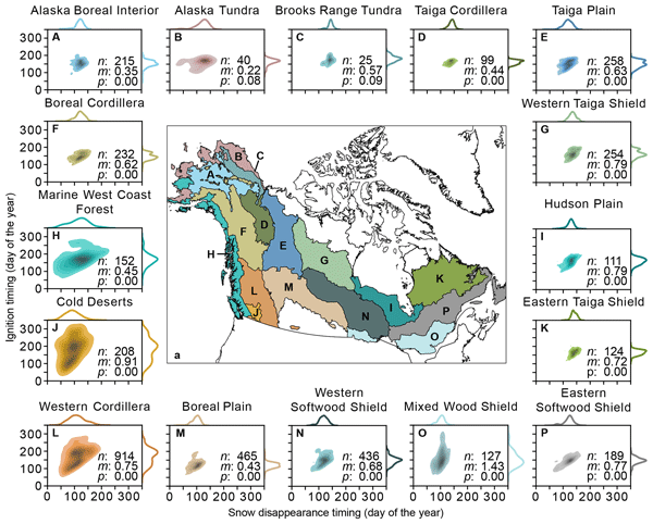
In boreal North America, snow and frozen ground prevail in winter, while fires occur in summer. Over the last 20 years, the northwestern parts have experienced earlier snow disappearance and more ignitions. This is opposite to the southeastern parts. However, earlier ignitions following earlier snow disappearance timing led to larger fires across the region. Snow disappearance timing may be a good proxy for ignition timing and may also influence important atmospheric conditions related to fires.
Pierre Friedlingstein, Michael O'Sullivan, Matthew W. Jones, Robbie M. Andrew, Dorothee C. E. Bakker, Judith Hauck, Peter Landschützer, Corinne Le Quéré, Ingrid T. Luijkx, Glen P. Peters, Wouter Peters, Julia Pongratz, Clemens Schwingshackl, Stephen Sitch, Josep G. Canadell, Philippe Ciais, Robert B. Jackson, Simone R. Alin, Peter Anthoni, Leticia Barbero, Nicholas R. Bates, Meike Becker, Nicolas Bellouin, Bertrand Decharme, Laurent Bopp, Ida Bagus Mandhara Brasika, Patricia Cadule, Matthew A. Chamberlain, Naveen Chandra, Thi-Tuyet-Trang Chau, Frédéric Chevallier, Louise P. Chini, Margot Cronin, Xinyu Dou, Kazutaka Enyo, Wiley Evans, Stefanie Falk, Richard A. Feely, Liang Feng, Daniel J. Ford, Thomas Gasser, Josefine Ghattas, Thanos Gkritzalis, Giacomo Grassi, Luke Gregor, Nicolas Gruber, Özgür Gürses, Ian Harris, Matthew Hefner, Jens Heinke, Richard A. Houghton, George C. Hurtt, Yosuke Iida, Tatiana Ilyina, Andrew R. Jacobson, Atul Jain, Tereza Jarníková, Annika Jersild, Fei Jiang, Zhe Jin, Fortunat Joos, Etsushi Kato, Ralph F. Keeling, Daniel Kennedy, Kees Klein Goldewijk, Jürgen Knauer, Jan Ivar Korsbakken, Arne Körtzinger, Xin Lan, Nathalie Lefèvre, Hongmei Li, Junjie Liu, Zhiqiang Liu, Lei Ma, Greg Marland, Nicolas Mayot, Patrick C. McGuire, Galen A. McKinley, Gesa Meyer, Eric J. Morgan, David R. Munro, Shin-Ichiro Nakaoka, Yosuke Niwa, Kevin M. O'Brien, Are Olsen, Abdirahman M. Omar, Tsuneo Ono, Melf Paulsen, Denis Pierrot, Katie Pocock, Benjamin Poulter, Carter M. Powis, Gregor Rehder, Laure Resplandy, Eddy Robertson, Christian Rödenbeck, Thais M. Rosan, Jörg Schwinger, Roland Séférian, T. Luke Smallman, Stephen M. Smith, Reinel Sospedra-Alfonso, Qing Sun, Adrienne J. Sutton, Colm Sweeney, Shintaro Takao, Pieter P. Tans, Hanqin Tian, Bronte Tilbrook, Hiroyuki Tsujino, Francesco Tubiello, Guido R. van der Werf, Erik van Ooijen, Rik Wanninkhof, Michio Watanabe, Cathy Wimart-Rousseau, Dongxu Yang, Xiaojuan Yang, Wenping Yuan, Xu Yue, Sönke Zaehle, Jiye Zeng, and Bo Zheng
Earth Syst. Sci. Data, 15, 5301–5369, https://doi.org/10.5194/essd-15-5301-2023, https://doi.org/10.5194/essd-15-5301-2023, 2023
Short summary
Short summary
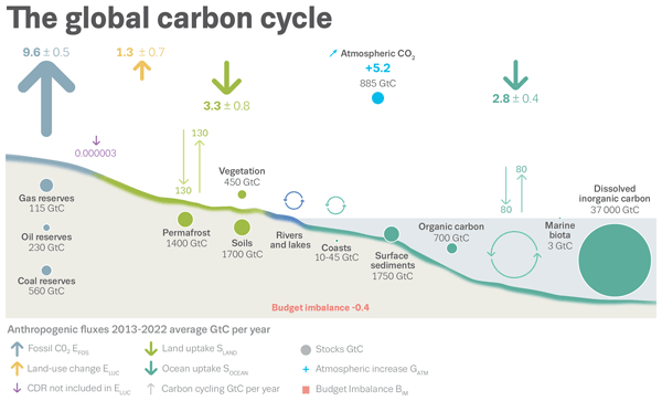
The Global Carbon Budget 2023 describes the methodology, main results, and data sets used to quantify the anthropogenic emissions of carbon dioxide (CO2) and their partitioning among the atmosphere, land ecosystems, and the ocean over the historical period (1750–2023). These living datasets are updated every year to provide the highest transparency and traceability in the reporting of CO2, the key driver of climate change.
Yang Chen, Joanne Hall, Dave van Wees, Niels Andela, Stijn Hantson, Louis Giglio, Guido R. van der Werf, Douglas C. Morton, and James T. Randerson
Earth Syst. Sci. Data, 15, 5227–5259, https://doi.org/10.5194/essd-15-5227-2023, https://doi.org/10.5194/essd-15-5227-2023, 2023
Short summary
Short summary
Using multiple sets of remotely sensed data, we created a dataset of monthly global burned area from 1997 to 2020. The estimated annual global burned area is 774 million hectares, significantly higher than previous estimates. Burned area declined by 1.21% per year due to extensive fire loss in savanna, grassland, and cropland ecosystems. This study enhances our understanding of the impact of fire on the carbon cycle and climate system, and may improve the predictions of future fire changes.
Roland Vernooij, Tom Eames, Jeremy Russell-Smith, Cameron Yates, Robin Beatty, Jay Evans, Andrew Edwards, Natasha Ribeiro, Martin Wooster, Tercia Strydom, Marcos Vinicius Giongo, Marco Assis Borges, Máximo Menezes Costa, Ana Carolina Sena Barradas, Dave van Wees, and Guido R. Van der Werf
Earth Syst. Dynam., 14, 1039–1064, https://doi.org/10.5194/esd-14-1039-2023, https://doi.org/10.5194/esd-14-1039-2023, 2023
Short summary
Short summary
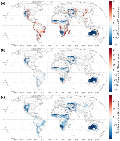
Savannas account for over half of global landscape fire emissions. Although environmental and fuel conditions affect the ratio of species the fire emits, these dynamics have not been implemented in global models. We measured CO2, CO, CH4, and N2O emission factors (EFs), fuel parameters, and fire severity proxies during 129 individual fires. We identified EF patterns and trained models to estimate EFs of these species based on satellite observations, reducing the estimation error by 60–85 %.
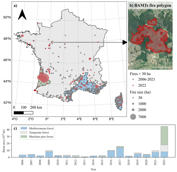
Lilian Vallet, Martin Schwartz, Philippe Ciais, Dave van Wees, Aurelien de Truchis, and Florent Mouillot
Biogeosciences, 20, 3803–3825, https://doi.org/10.5194/bg-20-3803-2023, https://doi.org/10.5194/bg-20-3803-2023, 2023
Short summary
Short summary
This study analyzes the ecological impact of the 2022 summer fire season in France by using high-resolution satellite data. The total biomass loss was 2.553 Mt, equivalent to a 17 % increase of the average natural mortality of all French forests. While Mediterranean forests had a lower biomass loss, there was a drastic increase in burned area and biomass loss over the Atlantic pine forests and temperate forests. This result revisits the distinctiveness of the 2022 fire season.
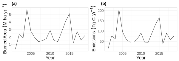
Stefano Potter, Sol Cooperdock, Sander Veraverbeke, Xanthe Walker, Michelle C. Mack, Scott J. Goetz, Jennifer Baltzer, Laura Bourgeau-Chavez, Arden Burrell, Catherine Dieleman, Nancy French, Stijn Hantson, Elizabeth E. Hoy, Liza Jenkins, Jill F. Johnstone, Evan S. Kane, Susan M. Natali, James T. Randerson, Merritt R. Turetsky, Ellen Whitman, Elizabeth Wiggins, and Brendan M. Rogers
Biogeosciences, 20, 2785–2804, https://doi.org/10.5194/bg-20-2785-2023, https://doi.org/10.5194/bg-20-2785-2023, 2023
Short summary
Short summary
Here we developed a new burned-area detection algorithm between 2001–2019 across Alaska and Canada at 500 m resolution. We estimate 2.37 Mha burned annually between 2001–2019 over the domain, emitting 79.3 Tg C per year, with a mean combustion rate of 3.13 kg C m−2. We found larger-fire years were generally associated with greater mean combustion. The burned-area and combustion datasets described here can be used for local- to continental-scale applications of boreal fire science.
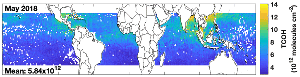
Daniel C. Anderson, Bryan N. Duncan, Julie M. Nicely, Junhua Liu, Sarah A. Strode, and Melanie B. Follette-Cook
Atmos. Chem. Phys., 23, 6319–6338, https://doi.org/10.5194/acp-23-6319-2023, https://doi.org/10.5194/acp-23-6319-2023, 2023
Short summary
Short summary
We describe a methodology that combines machine learning, satellite observations, and 3D chemical model output to infer the abundance of the hydroxyl radical (OH), a chemical that removes many trace gases from the atmosphere. The methodology successfully captures the variability of observed OH, although further observations are needed to evaluate absolute accuracy. Current satellite observations are of sufficient quality to infer OH, but retrieval validation in the remote tropics is needed.
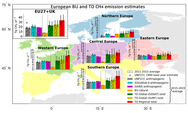
Ana Maria Roxana Petrescu, Chunjing Qiu, Matthew J. McGrath, Philippe Peylin, Glen P. Peters, Philippe Ciais, Rona L. Thompson, Aki Tsuruta, Dominik Brunner, Matthias Kuhnert, Bradley Matthews, Paul I. Palmer, Oksana Tarasova, Pierre Regnier, Ronny Lauerwald, David Bastviken, Lena Höglund-Isaksson, Wilfried Winiwarter, Giuseppe Etiope, Tuula Aalto, Gianpaolo Balsamo, Vladislav Bastrikov, Antoine Berchet, Patrick Brockmann, Giancarlo Ciotoli, Giulia Conchedda, Monica Crippa, Frank Dentener, Christine D. Groot Zwaaftink, Diego Guizzardi, Dirk Günther, Jean-Matthieu Haussaire, Sander Houweling, Greet Janssens-Maenhout, Massaer Kouyate, Adrian Leip, Antti Leppänen, Emanuele Lugato, Manon Maisonnier, Alistair J. Manning, Tiina Markkanen, Joe McNorton, Marilena Muntean, Gabriel D. Oreggioni, Prabir K. Patra, Lucia Perugini, Isabelle Pison, Maarit T. Raivonen, Marielle Saunois, Arjo J. Segers, Pete Smith, Efisio Solazzo, Hanqin Tian, Francesco N. Tubiello, Timo Vesala, Guido R. van der Werf, Chris Wilson, and Sönke Zaehle
Earth Syst. Sci. Data, 15, 1197–1268, https://doi.org/10.5194/essd-15-1197-2023, https://doi.org/10.5194/essd-15-1197-2023, 2023
Short summary
Short summary
This study updates the state-of-the-art scientific overview of CH4 and N2O emissions in the EU27 and UK in Petrescu et al. (2021a). Yearly updates are needed to improve the different respective approaches and to inform on the development of formal verification systems. It integrates the most recent emission inventories, process-based model and regional/global inversions, comparing them with UNFCCC national GHG inventories, in support to policy to facilitate real-time verification procedures.
Jose V. Moris, Pedro Álvarez-Álvarez, Marco Conedera, Annalie Dorph, Thomas D. Hessilt, Hugh G. P. Hunt, Renata Libonati, Lucas S. Menezes, Mortimer M. Müller, Francisco J. Pérez-Invernón, Gianni B. Pezzatti, Nicolau Pineda, Rebecca C. Scholten, Sander Veraverbeke, B. Mike Wotton, and Davide Ascoli
Earth Syst. Sci. Data, 15, 1151–1163, https://doi.org/10.5194/essd-15-1151-2023, https://doi.org/10.5194/essd-15-1151-2023, 2023
Short summary
Short summary
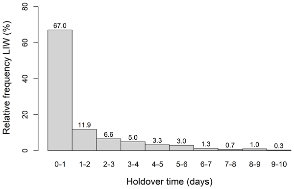
This work describes a database on holdover times of lightning-ignited wildfires (LIWs). Holdover time is defined as the time between lightning-induced fire ignition and fire detection. The database contains 42 datasets built with data on more than 152 375 LIWs from 13 countries in five continents from 1921 to 2020. This database is the first freely-available, harmonized and ready-to-use global source of holdover time data, which may be used to investigate LIWs and model the holdover phenomenon.
Fa Li, Qing Zhu, William J. Riley, Lei Zhao, Li Xu, Kunxiaojia Yuan, Min Chen, Huayi Wu, Zhipeng Gui, Jianya Gong, and James T. Randerson
Geosci. Model Dev., 16, 869–884, https://doi.org/10.5194/gmd-16-869-2023, https://doi.org/10.5194/gmd-16-869-2023, 2023
Short summary
Short summary
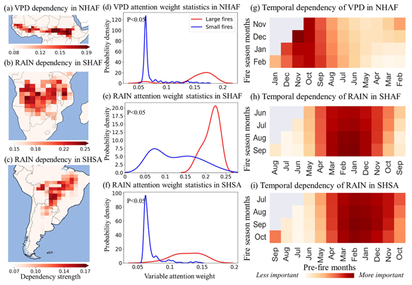
We developed an interpretable machine learning model to predict sub-seasonal and near-future wildfire-burned area over African and South American regions. We found strong time-lagged controls (up to 6–8 months) of local climate wetness on burned areas. A skillful use of such time-lagged controls in machine learning models results in highly accurate predictions of wildfire-burned areas; this will also help develop relevant early-warning and management systems for tropical wildfires.
Dave van Wees, Guido R. van der Werf, James T. Randerson, Brendan M. Rogers, Yang Chen, Sander Veraverbeke, Louis Giglio, and Douglas C. Morton
Geosci. Model Dev., 15, 8411–8437, https://doi.org/10.5194/gmd-15-8411-2022, https://doi.org/10.5194/gmd-15-8411-2022, 2022
Short summary
Short summary
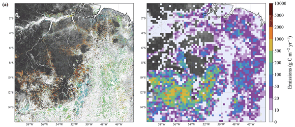
We present a global fire emission model based on the GFED model framework with a spatial resolution of 500 m. The higher resolution allowed for a more detailed representation of spatial heterogeneity in fuels and emissions. Specific modules were developed to model, for example, emissions from fire-related forest loss and belowground burning. Results from the 500 m model were compared to GFED4s, showing that global emissions were relatively similar but that spatial differences were substantial.
Pierre Friedlingstein, Michael O'Sullivan, Matthew W. Jones, Robbie M. Andrew, Luke Gregor, Judith Hauck, Corinne Le Quéré, Ingrid T. Luijkx, Are Olsen, Glen P. Peters, Wouter Peters, Julia Pongratz, Clemens Schwingshackl, Stephen Sitch, Josep G. Canadell, Philippe Ciais, Robert B. Jackson, Simone R. Alin, Ramdane Alkama, Almut Arneth, Vivek K. Arora, Nicholas R. Bates, Meike Becker, Nicolas Bellouin, Henry C. Bittig, Laurent Bopp, Frédéric Chevallier, Louise P. Chini, Margot Cronin, Wiley Evans, Stefanie Falk, Richard A. Feely, Thomas Gasser, Marion Gehlen, Thanos Gkritzalis, Lucas Gloege, Giacomo Grassi, Nicolas Gruber, Özgür Gürses, Ian Harris, Matthew Hefner, Richard A. Houghton, George C. Hurtt, Yosuke Iida, Tatiana Ilyina, Atul K. Jain, Annika Jersild, Koji Kadono, Etsushi Kato, Daniel Kennedy, Kees Klein Goldewijk, Jürgen Knauer, Jan Ivar Korsbakken, Peter Landschützer, Nathalie Lefèvre, Keith Lindsay, Junjie Liu, Zhu Liu, Gregg Marland, Nicolas Mayot, Matthew J. McGrath, Nicolas Metzl, Natalie M. Monacci, David R. Munro, Shin-Ichiro Nakaoka, Yosuke Niwa, Kevin O'Brien, Tsuneo Ono, Paul I. Palmer, Naiqing Pan, Denis Pierrot, Katie Pocock, Benjamin Poulter, Laure Resplandy, Eddy Robertson, Christian Rödenbeck, Carmen Rodriguez, Thais M. Rosan, Jörg Schwinger, Roland Séférian, Jamie D. Shutler, Ingunn Skjelvan, Tobias Steinhoff, Qing Sun, Adrienne J. Sutton, Colm Sweeney, Shintaro Takao, Toste Tanhua, Pieter P. Tans, Xiangjun Tian, Hanqin Tian, Bronte Tilbrook, Hiroyuki Tsujino, Francesco Tubiello, Guido R. van der Werf, Anthony P. Walker, Rik Wanninkhof, Chris Whitehead, Anna Willstrand Wranne, Rebecca Wright, Wenping Yuan, Chao Yue, Xu Yue, Sönke Zaehle, Jiye Zeng, and Bo Zheng
Earth Syst. Sci. Data, 14, 4811–4900, https://doi.org/10.5194/essd-14-4811-2022, https://doi.org/10.5194/essd-14-4811-2022, 2022
Short summary
Short summary
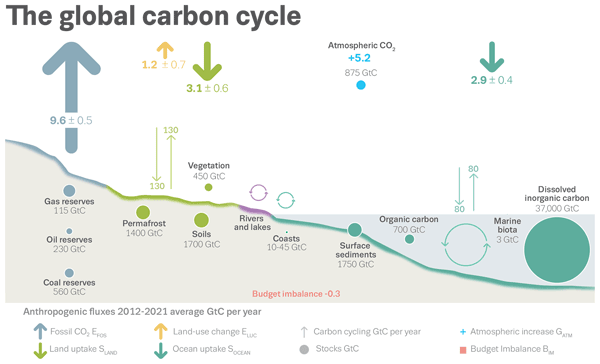
The Global Carbon Budget 2022 describes the datasets and methodology used to quantify the anthropogenic emissions of carbon dioxide (CO2) and their partitioning among the atmosphere, the land ecosystems, and the ocean. These living datasets are updated every year to provide the highest transparency and traceability in the reporting of CO2, the key driver of climate change.
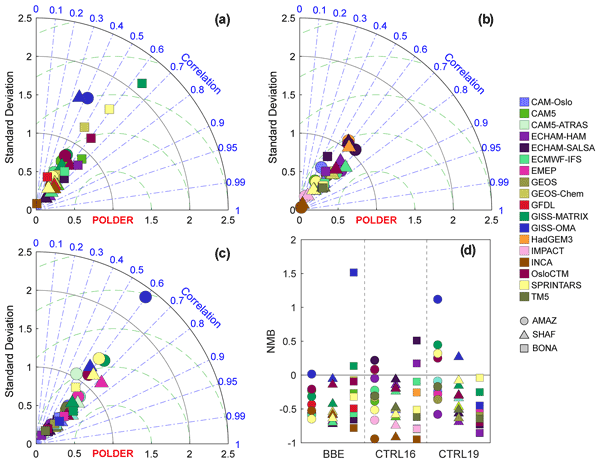
Qirui Zhong, Nick Schutgens, Guido van der Werf, Twan van Noije, Kostas Tsigaridis, Susanne E. Bauer, Tero Mielonen, Alf Kirkevåg, Øyvind Seland, Harri Kokkola, Ramiro Checa-Garcia, David Neubauer, Zak Kipling, Hitoshi Matsui, Paul Ginoux, Toshihiko Takemura, Philippe Le Sager, Samuel Rémy, Huisheng Bian, Mian Chin, Kai Zhang, Jialei Zhu, Svetlana G. Tsyro, Gabriele Curci, Anna Protonotariou, Ben Johnson, Joyce E. Penner, Nicolas Bellouin, Ragnhild B. Skeie, and Gunnar Myhre
Atmos. Chem. Phys., 22, 11009–11032, https://doi.org/10.5194/acp-22-11009-2022, https://doi.org/10.5194/acp-22-11009-2022, 2022
Short summary
Short summary
Aerosol optical depth (AOD) errors for biomass burning aerosol (BBA) are evaluated in 18 global models against satellite datasets. Notwithstanding biases in satellite products, they allow model evaluations. We observe large and diverse model biases due to errors in BBA. Further interpretations of AOD diversities suggest large biases exist in key processes for BBA which require better constraining. These results can contribute to further model improvement and development.
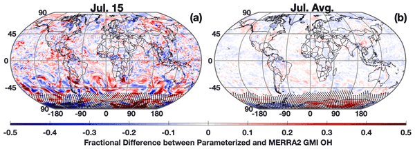
Daniel C. Anderson, Melanie B. Follette-Cook, Sarah A. Strode, Julie M. Nicely, Junhua Liu, Peter D. Ivatt, and Bryan N. Duncan
Geosci. Model Dev., 15, 6341–6358, https://doi.org/10.5194/gmd-15-6341-2022, https://doi.org/10.5194/gmd-15-6341-2022, 2022
Short summary
Short summary
The hydroxyl radical (OH) is the most important chemical in the atmosphere for removing certain pollutants, including methane, the second-most-important greenhouse gas. We present a methodology to create an easily modifiable parameterization that can calculate OH concentrations in a computationally efficient way. The parameterization, which predicts OH within 5 %, can be integrated into larger climate models to allow for calculation of the interactions between OH, methane, and other chemicals.
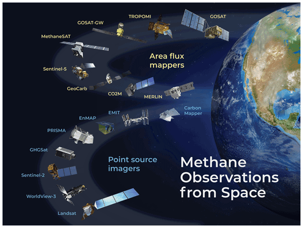
Daniel J. Jacob, Daniel J. Varon, Daniel H. Cusworth, Philip E. Dennison, Christian Frankenberg, Ritesh Gautam, Luis Guanter, John Kelley, Jason McKeever, Lesley E. Ott, Benjamin Poulter, Zhen Qu, Andrew K. Thorpe, John R. Worden, and Riley M. Duren
Atmos. Chem. Phys., 22, 9617–9646, https://doi.org/10.5194/acp-22-9617-2022, https://doi.org/10.5194/acp-22-9617-2022, 2022
Short summary
Short summary
We review the capability of satellite observations of atmospheric methane to quantify methane emissions on all scales. We cover retrieval methods, precision requirements, inverse methods for inferring emissions, source detection thresholds, and observations of system completeness. We show that current instruments already enable quantification of regional and national emissions including contributions from large point sources. Coverage and resolution will increase significantly in coming years.
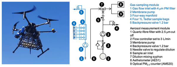
Roland Vernooij, Patrik Winiger, Martin Wooster, Tercia Strydom, Laurent Poulain, Ulrike Dusek, Mark Grosvenor, Gareth J. Roberts, Nick Schutgens, and Guido R. van der Werf
Atmos. Meas. Tech., 15, 4271–4294, https://doi.org/10.5194/amt-15-4271-2022, https://doi.org/10.5194/amt-15-4271-2022, 2022
Short summary
Short summary
Landscape fires are a substantial emitter of greenhouse gases and aerosols. Previous studies have indicated savanna emission factors to be highly variable. Improving fire emission estimates, and understanding future climate- and human-induced changes in fire regimes, requires in situ measurements. We present a drone-based method that enables the collection of a large amount of high-quality emission factor measurements that do not have the biases of aircraft or surface measurements.
Colm Sweeney, Abhishek Chatterjee, Sonja Wolter, Kathryn McKain, Robert Bogue, Stephen Conley, Tim Newberger, Lei Hu, Lesley Ott, Benjamin Poulter, Luke Schiferl, Brad Weir, Zhen Zhang, and Charles E. Miller
Atmos. Chem. Phys., 22, 6347–6364, https://doi.org/10.5194/acp-22-6347-2022, https://doi.org/10.5194/acp-22-6347-2022, 2022
Short summary
Short summary
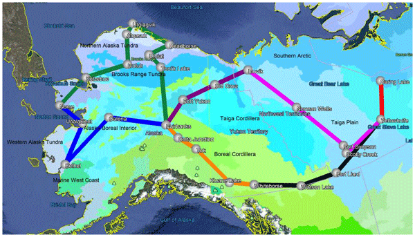
The Arctic Carbon Atmospheric Profiles (Arctic-CAP) project demonstrates the utility of aircraft profiles for independent evaluation of model-derived emissions and uptake of atmospheric CO2, CH4, and CO from land and ocean. Comparison with the Goddard Earth Observing System (GEOS) modeling system suggests that fluxes of CO2 are very consistent with observations, while those of CH4 have some regional and seasonal biases, and that CO comparison is complicated by transport errors.
Pierre Friedlingstein, Matthew W. Jones, Michael O'Sullivan, Robbie M. Andrew, Dorothee C. E. Bakker, Judith Hauck, Corinne Le Quéré, Glen P. Peters, Wouter Peters, Julia Pongratz, Stephen Sitch, Josep G. Canadell, Philippe Ciais, Rob B. Jackson, Simone R. Alin, Peter Anthoni, Nicholas R. Bates, Meike Becker, Nicolas Bellouin, Laurent Bopp, Thi Tuyet Trang Chau, Frédéric Chevallier, Louise P. Chini, Margot Cronin, Kim I. Currie, Bertrand Decharme, Laique M. Djeutchouang, Xinyu Dou, Wiley Evans, Richard A. Feely, Liang Feng, Thomas Gasser, Dennis Gilfillan, Thanos Gkritzalis, Giacomo Grassi, Luke Gregor, Nicolas Gruber, Özgür Gürses, Ian Harris, Richard A. Houghton, George C. Hurtt, Yosuke Iida, Tatiana Ilyina, Ingrid T. Luijkx, Atul Jain, Steve D. Jones, Etsushi Kato, Daniel Kennedy, Kees Klein Goldewijk, Jürgen Knauer, Jan Ivar Korsbakken, Arne Körtzinger, Peter Landschützer, Siv K. Lauvset, Nathalie Lefèvre, Sebastian Lienert, Junjie Liu, Gregg Marland, Patrick C. McGuire, Joe R. Melton, David R. Munro, Julia E. M. S. Nabel, Shin-Ichiro Nakaoka, Yosuke Niwa, Tsuneo Ono, Denis Pierrot, Benjamin Poulter, Gregor Rehder, Laure Resplandy, Eddy Robertson, Christian Rödenbeck, Thais M. Rosan, Jörg Schwinger, Clemens Schwingshackl, Roland Séférian, Adrienne J. Sutton, Colm Sweeney, Toste Tanhua, Pieter P. Tans, Hanqin Tian, Bronte Tilbrook, Francesco Tubiello, Guido R. van der Werf, Nicolas Vuichard, Chisato Wada, Rik Wanninkhof, Andrew J. Watson, David Willis, Andrew J. Wiltshire, Wenping Yuan, Chao Yue, Xu Yue, Sönke Zaehle, and Jiye Zeng
Earth Syst. Sci. Data, 14, 1917–2005, https://doi.org/10.5194/essd-14-1917-2022, https://doi.org/10.5194/essd-14-1917-2022, 2022
Short summary
Short summary
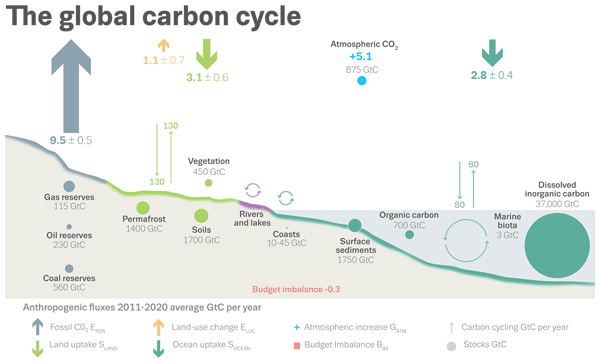
The Global Carbon Budget 2021 describes the data sets and methodology used to quantify the emissions of carbon dioxide and their partitioning among the atmosphere, land, and ocean. These living data are updated every year to provide the highest transparency and traceability in the reporting of CO2, the key driver of climate change.
Lei Ma, George Hurtt, Lesley Ott, Ritvik Sahajpal, Justin Fisk, Rachel Lamb, Hao Tang, Steve Flanagan, Louise Chini, Abhishek Chatterjee, and Joseph Sullivan
Geosci. Model Dev., 15, 1971–1994, https://doi.org/10.5194/gmd-15-1971-2022, https://doi.org/10.5194/gmd-15-1971-2022, 2022
Short summary
Short summary
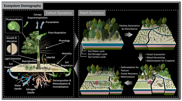
We present a global version of the Ecosystem Demography (ED) model which can track vegetation 3-D structure and scale up ecological processes from individual vegetation to ecosystem scale. Model evaluation against multiple benchmarking datasets demonstrated the model’s capability to simulate global vegetation dynamics across a range of temporal and spatial scales. With this version, ED has the potential to be linked with remote sensing observations to address key scientific questions.
Qing Zhu, Fa Li, William J. Riley, Li Xu, Lei Zhao, Kunxiaojia Yuan, Huayi Wu, Jianya Gong, and James Randerson
Geosci. Model Dev., 15, 1899–1911, https://doi.org/10.5194/gmd-15-1899-2022, https://doi.org/10.5194/gmd-15-1899-2022, 2022
Short summary
Short summary
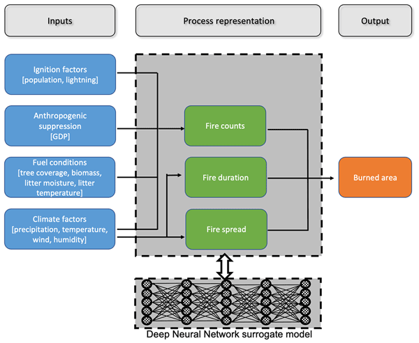
Wildfire is a devastating Earth system process that burns about 500 million hectares of land each year. It wipes out vegetation including trees, shrubs, and grasses and causes large losses of economic assets. However, modeling the spatial distribution and temporal changes of wildfire activities at a global scale is challenging. This study built a machine-learning-based wildfire surrogate model within an existing Earth system model and achieved high accuracy.
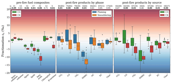
Roland Vernooij, Ulrike Dusek, Maria Elena Popa, Peng Yao, Anupam Shaikat, Chenxi Qiu, Patrik Winiger, Carina van der Veen, Thomas Callum Eames, Natasha Ribeiro, and Guido R. van der Werf
Atmos. Chem. Phys., 22, 2871–2890, https://doi.org/10.5194/acp-22-2871-2022, https://doi.org/10.5194/acp-22-2871-2022, 2022
Short summary
Short summary
Landscape fires are a major source of greenhouse gases and aerosols, particularly in sub-tropical savannas. Stable carbon isotopes in emissions can be used to trace the contribution of C3 plants (e.g. trees or shrubs) and C4 plants (e.g. savanna grasses) to greenhouse gases and aerosols if the process is well understood. This helps us to link individual vegetation types to emissions, identify biomass burning emissions in the atmosphere, and improve the reconstruction of historic fire regimes.
Cited articles
Ahmadov, R., Grell, G., James, E., Csiszar, I., Tsidulko, M., Pierce, B., McKeen, S., Benjamin, S., Alexander, C., Pereira, G., Freitas, S., and Goldberg, M.: Using VIIRS fire radiative power data to simulate biomass burning emissions, plume rise and smoke transport in a real-time air quality modeling system, in: Proceedings of the 2017 IEEE International Geoscience and Remote Sensing Symposium (IGARSS), Fort Worth, TX, USA, 23–28 July 2017, 2806–2808, https://doi.org/10.1109/IGARSS.2017.8127581, 2017.
Alencar, A. A. C., Arruda, V. L. S., da Silva, W. V., Conciani, D. E., Costa, D. P., Crusco, N., Duverger, S. G., Ferreira, N. C., Franca-Rocha, W., Hasenack, H., Martenexen, L. F. M., Piontekowski, V. J., Ribeiro, N. V., Rosa, E. R., Rosa, M. R., dos Santos, S. M. B., Shimbo, J. Z., and Vélez-Martin, E.: Long-term Landsat-based monthly burned area dataset for the Brazilian biomes using deep learning, Remote Sens., 14, 2510, https://doi.org/10.3390/rs14112510, 2022.
Andela, N., Kaiser, J. W., van der Werf, G. R., and Wooster, M. J.: New fire diurnal cycle characterizations to improve fire radiative energy assessments made from MODIS observations, Atmos. Chem. Phys., 15, 8831–8846, https://doi.org/10.5194/acp-15-8831-2015, 2015.
Andela, N., Morton, D. C., Giglio, L., Chen, Y., van der Werf, G. R., Kasibhatla, P. S., DeFries, R. S., Collatz, G. J., Hantson, S., Kloster, S., and Bachelet, D.: A human-driven decline in global burned area, Science, 356, 1356–1362, https://doi.org/10.1126/science.aal4108, 2017.
Balch, J. K., Abatzoglou, J. T., Joseph, M. B., Koontz, M. J., Mahood, A. L., McGlinchy, J., Cattau, M. E., and Williams, A. P.: Warming weakens the night-time barrier to global fire, Nature, 602, 442–448, https://doi.org/10.1038/s41586-021-04325-1, 2022.
Binte Shahid, S., Lacey, F. G., Wiedinmyer, C., Yokelson, R. J., and Barsanti, K. C.: NEIVAv1.0: Next-generation Emissions InVentory expansion of Akagi et al. (2011) version 1.0, Geosci. Model Dev., 17, 7679–7711, https://doi.org/10.5194/gmd-17-7679-2024, 2024.
Chen, B., Wu, S., Jin, Y., Song, Y., Wu, C., Venevsky, S., Xu, B., Webster, C., and Gong, P.: Wildfire risk for global wildland–urban interface areas, Nat. Sustain., 7, 474–484, https://doi.org/10.1038/s41893-024-01291-0, 2024.
Chen, Y., Hall, J., van Wees, D., Andela, N., Hantson, S., Giglio, L., van der Werf, G. R., Morton, D. C., and Randerson, J. T.: Multi-decadal trends and variability in burned area from the fifth version of the Global Fire Emissions Database (GFED5), Earth Syst. Sci. Data, 15, 5227–5259, https://doi.org/10.5194/essd-15-5227-2023, 2023.
Chen, Y., van der Werf, G., Mu, M., van Wees, D., Hall, J., Giglio, L., Vernooij, R., Morton, D., Xu, L., Liu, T., Scholten, R., Coffield, S., Follette-Cook, M., Ott, L., and Randerson, J.: GFED5NRT: Global Fire Emissions Database Near-Real-Time Extension (V5.1), Zenodo [data set], https://doi.org/10.5281/zenodo.18702700, 2026.
Collier, N., Hoffman, F. M., Lawrence, D. M., Keppel-Aleks, G., Koven, C. D., Riley, W. J., Mu, M., and Randerson, J. T.: The International Land Model Benchmarking (ILAMB) system: design, theory, and implementation, J. Adv. Model. Earth Sy., 10, 2731–2754, https://doi.org/10.1029/2018MS001354, 2018.
Cunningham, C. X., Williamson, G. J., and Bowman, D. M. J. S.: Increasing frequency and intensity of the most extreme wildfires on Earth, Nat. Ecol. Evol., 8, 1420–1425, https://doi.org/10.1038/s41559-024-02452-2, 2024.
Darmenov, A. and da Silva, A.: The Quick Fire Emissions Dataset (QFED) – documentation of versions 2.1, 2.2 and 2.4, NASA Technical Report Series on Global Modeling and Data Assimilation, NASA/TM-2013-104606, Vol. 32, National Aeronautics and Space Administration, Goddard Space Flight Center, Greenbelt, Maryland, USA, 183 pp., https://ntrs.nasa.gov/citations/20180005253 (last access: 6 October 2026), 2015.
Friedl, M. and Sulla-Menashe, D.: MODIS/Terra+Aqua Land Cover Type Yearly L3 Global 500m SIN Grid V061, NASA EOSDIS Land Processes Distributed Active Archive Center [data set], https://doi.org/10.5067/MODIS/MCD12Q1.061, 2022.
Giglio, L., van der Werf, G. R., Randerson, J. T., Collatz, G. J., and Kasibhatla, P.: Global estimation of burned area using MODIS active fire observations, Atmos. Chem. Phys., 6, 957–974, https://doi.org/10.5194/acp-6-957-2006, 2006.
Giglio, L., Randerson, J. T., van der Werf, G. R., Kasibhatla, P. S., Collatz, G. J., Morton, D. C., and DeFries, R. S.: Assessing variability and long-term trends in burned area by merging multiple satellite fire products, Biogeosciences, 7, 1171–1186, https://doi.org/10.5194/bg-7-1171-2010, 2010.
Giglio, L., Boschetti, L., Roy, D. P., Humber, M. L., and Justice, C. O.: The Collection 6 MODIS burned area mapping algorithm and product, Remote Sens. Environ., 217, 72–85, https://doi.org/10.1016/j.rse.2018.08.005, 2018.
Giglio, L., Boschetti, L., Roy, D. P., Hall, J. V., Zubkova, M., Humber, M., Huang, H., and Oles, V.: The NASA VIIRS burned area product, global validation, and intercomparison with the NASA MODIS burned area product, Remote Sens. Environ., 331, 115006, https://doi.org/10.1016/j.rse.2025.115006, 2025.
Gincheva, A., Pausas, J. G., Edwards, A., Provenzale, A., Cerdà, A., Hanes, C., Royé, D., Chuvieco, E., Mouillot, F., Vissio, G., Rodrigo, J., Bedía, J., Abatzoglou, J. T., Senciales González, J. M., Short, K. C., Baudena, M., Llasat, M. C., Magnani, M., Boer, M. M., González, M. E., Torres-Vázquez, M. Á., Fiorucci, P., Jacklyn, P., Libonati, R., Trigo, R. M., Herrera, S., Jerez, S., Wang, X., and Turco, M.: A monthly gridded burned area database of national wildland fire data, Sci. Data, 11, 352, https://doi.org/10.1038/s41597-024-03141-2, 2024.
Gumbricht, T., Roman-Cuesta, R. M., Verchot, L., Herold, M., Wittmann, F., Householder, E., Herold, N., and Murdiyarso, D.: An expert system model for mapping tropical wetlands and peatlands reveals South America as the largest contributor, Glob. Change Biol., 23, 3581–3599, https://doi.org/10.1111/gcb.13689, 2017.
Guo, Y., Wang, J., Ge, Y., and Zhou, C.: Global expansion of wildland–urban interface intensifies human exposure to wildfire risk in the 21st century, Sci. Adv., 10, eado9587, https://doi.org/10.1126/sciadv.ado9587, 2024.
Hall, J. V., Loboda, T. V., Giglio, L., and McCarty, G. W.: A MODIS-based burned area assessment for Russian croplands: mapping requirements and challenges, Remote Sens. Environ., 184, 506–521, https://doi.org/10.1016/j.rse.2016.07.022, 2016.
Hall, J. V., Argueta, F., Zubkova, M., Chen, Y., Randerson, J. T., and Giglio, L.: GloCAB: global cropland burned area from mid-2002 to 2020, Earth Syst. Sci. Data, 16, 867–885, https://doi.org/10.5194/essd-16-867-2024, 2024.
Jain, P., Castellanos-Acuna, D., Coogan, S. C. P., Abatzoglou, J. T., and Flannigan, M. D.: Observed increases in extreme fire weather driven by atmospheric humidity and temperature, Nat. Clim. Change, 12, 63–70, https://doi.org/10.1038/s41558-021-01224-1, 2022.
Jones, M. W., Abatzoglou, J. T., Veraverbeke, S., Andela, N., Lasslop, G., Forkel, M., Smith, A. J. P., Burton, C., Betts, R. A., van der Werf, G. R., Sitch, S., Canadell, J. G., Santín, C., Kolden, C., Doerr, S. H., and Le Quéré, C.: Global and regional trends and drivers of fire under climate change, Rev. Geophys., 60, e2020RG000726, https://doi.org/10.1029/2020RG000726, 2022.
Jones, M. W., Kelley, D. I., Burton, C. A., Di Giuseppe, F., Barbosa, M. L. F., Brambleby, E., Hartley, A. J., Lombardi, A., Mataveli, G., McNorton, J. R., Spuler, F. R., Wessel, J. B., Abatzoglou, J. T., Anderson, L. O., Andela, N., Archibald, S., Armenteras, D., Burke, E., Carmenta, R., Chuvieco, E., Clarke, H., Doerr, S. H., Fernandes, P. M., Giglio, L., Hamilton, D. S., Hantson, S., Harris, S., Jain, P., Kolden, C. A., Kurvits, T., Lampe, S., Meier, S., New, S., Parrington, M., Perron, M. M. G., Qu, Y., Ribeiro, N. S., Saharjo, B. H., San-Miguel-Ayanz, J., Shuman, J. K., Tanpipat, V., van der Werf, G. R., Veraverbeke, S., and Xanthopoulos, G.: State of Wildfires 2023–2024, Earth Syst. Sci. Data, 16, 3601–3685, https://doi.org/10.5194/essd-16-3601-2024, 2024.
Justice, C. O., Giglio, L., Korontzi, S., Owens, J., Morisette, J. T., Roy, D., Descloitres, J., Alleaume, S., Petitcolin, F., and Kaufman, Y.: The MODIS fire products, Remote Sens. Environ., 83, 244–262, https://doi.org/10.1016/S0034-4257(02)00076-7, 2002.
Kaiser, J. W., Heil, A., Andreae, M. O., Benedetti, A., Chubarova, N., Jones, L., Morcrette, J.-J., Razinger, M., Schultz, M. G., Suttie, M., and van der Werf, G. R.: Biomass burning emissions estimated with a global fire assimilation system based on observed fire radiative power, Biogeosciences, 9, 527–554, https://doi.org/10.5194/bg-9-527-2012, 2012.
Li, F., Zhang, X., Kondragunta, S., Lu, X., Csiszar, I., and Schmidt, C. C.: Hourly biomass burning emissions product from blended geostationary and polar-orbiting satellites for air quality forecasting applications, Remote Sens. Environ., 281, 113237, https://doi.org/10.1016/j.rse.2022.113237, 2022.
Libonati, R., DaCamara, C., Setzer, A., Morelli, F., and Melchiori, A.: An algorithm for burned area detection in the Brazilian Cerrado using 4 µm MODIS imagery, Remote Sens., 7, 15782–15803, https://doi.org/10.3390/rs71215782, 2015.
Loeb, N. G., Doelling, D. R., Kato, S., Su, W., Mlynczak, P. E., and Wilkins, J. C.: Continuity in top-of-atmosphere Earth radiation budget observations, J. Climate, 37, 6093–6108, https://doi.org/10.1175/JCLI-D-24-0180.1, 2024.
Mu, M., Randerson, J. T., van der Werf, G. R., Giglio, L., Kasibhatla, P., Morton, D., Collatz, G. J., DeFries, R. S., Hyer, E. J., Prins, E. M., Griffith, D. W. T., Wunch, D., Toon, G. C., Sherlock, V., and Wennberg, P. O.: Daily and 3-hourly variability in global fire emissions and consequences for atmospheric model predictions of carbon monoxide, J. Geophys. Res.-Atmos., 116, D24303, https://doi.org/10.1029/2011JD016245, 2011.
Parkinson, C. L.: The Earth-observing Aqua satellite mission: 20 years and counting, Earth Space Sci., 9, e2022EA002481, https://doi.org/10.1029/2022EA002481, 2022.
Pelletier, F., Cardille, J. A., Wulder, M. A., White, J. C., and Hermosilla, T.: Revisiting the 2023 wildfire season in Canada, Sci. Remote Sens., 10, 100145, https://doi.org/10.1016/j.srs.2024.100145, 2024.
Potter, C. S., Randerson, J. T., Field, C. B., Matson, P. A., Vitousek, P. M., Mooney, H. A., and Klooster, S. A.: Terrestrial ecosystem production: a process model based on global satellite and surface data, Global Biogeochem. Cy., 7, 811–841, https://doi.org/10.1029/93GB02725, 1993.
Randerson, J. T., Chen, Y., van der Werf, G. R., Rogers, B. M., and Morton, D. C.: Global burned area and biomass burning emissions from small fires, J. Geophys. Res.-Biogeosci., 117, G04012, https://doi.org/10.1029/2012JG002128, 2012.
Román, M. O., Justice, C., Paynter, I., Boucher, P. B., Devadiga, S., Endsley, A., Erb, A., Friedl, M., Gao, H., Giglio, L., Gray, J. M., Hall, D., Hulley, G., Kimball, J., Knyazikhin, Y., Lyapustin, A., Myneni, R. B., Noojipady, P., Pu, J., Riggs, G., Sarkar, S., Schaaf, C., Shah, D., Tran, K. H., Vermote, E., Wang, D., Wang, Z., Wu, A., Ye, Y., Shen, Y., Zhang, S., Zhang, S., Zhang, X., Zhao, M., Davidson, C., and Wolfe, R.: Continuity between NASA MODIS Collection 6.1 and VIIRS Collection 2 land products, Remote Sens. Environ., 302, 113963, https://doi.org/10.1016/j.rse.2023.113963, 2024.
Schroeder, W., Ruminski, M., Csiszar, I., Giglio, L., Prins, E., Schmidt, C., and Morisette, J.: Validation analyses of an operational fire monitoring product: the Hazard Mapping System, Int. J. Remote Sens., 29, 6059–6066, https://doi.org/10.1080/01431160802235845, 2008.
Schroeder, W., Giglio, L., and Hall, J.: Collection 2 Visible Infrared Imaging Radiometer Suite (VIIRS) 375 m active fire product user's guide, Version 1.2, NASA/NOAA, 16 pp., https://www.earthdata.nasa.gov/s3fs-public/2025-06/VIIRS_C2_AF-375m_User_Guide_1.2.pdf (last access: 6 October 2026), 2025.
Schug, F., Bar-Massada, A., Carlson, A. R., Cox, H., Hawbaker, T. J., Helmers, D., Hostert, P., Kaim, D., Kasraee, N. K., Martinuzzi, S., Mockrin, M. H., Pfoch, K. A., and Radeloff, V. C.: The global wildland–urban interface, Nature, 621, 94–99, https://doi.org/10.1038/s41586-023-06320-0, 2023.
Seiler, W. and Crutzen, P. J.: Estimates of gross and net fluxes of carbon between the biosphere and the atmosphere from biomass burning, Climatic Change, 2, 207–247, https://doi.org/10.1007/BF00137988, 1980.
Short, K. C.: Spatial wildfire occurrence data for the United States, 1992–2020 [FPA_FOD_20221014], 6th edn., Forest Service Research Data Archive, Fort Collins, CO [data set], https://doi.org/10.2737/RDS-2013-0009.6, 2022.
Souza, C. M., Jr., Shimbo, J. Z., Rosa, M. R., Parente, L. L., Alencar, A. A., Rudorff, B. F. T., Hasenack, H., Matsumoto, M., Ferreira, L. G., Souza-Filho, P. W. M., de Oliveira, S. W., Rocha, W. F., Fonseca, A. V., Marques, C. B., Diniz, C. G., Costa, D., Monteiro, D., Rosa, E. R., Vélez-Martin, E., Weber, E. J., Lenti, F. E. B., Paternost, F. F., Pareyn, F. G. C., Siqueira, J. V., Viera, J. L., Ferreira Neto, L. C., Saraiva, M. M., Sales, M. H., Salgado, M. P. G., Vasconcelos, R., Galano, S., Mesquita, V. V., and Azevedo, T.: Reconstructing three decades of land use and land cover changes in Brazilian biomes with Landsat archive and Earth Engine, Remote Sens., 12, 2735, https://doi.org/10.3390/rs12172735, 2020.
Tang, W., He, C., Emmons, L., and Zhang, J.: Global expansion of wildland–urban interface (WUI) and WUI fires: insights from a multiyear worldwide unified database (WUWUI), Environ. Res. Lett., 19, 044028, https://doi.org/10.1088/1748-9326/ad31da, 2024.
Taylor, K. E.: Summarizing multiple aspects of model performance in a single diagram, J. Geophys. Res., 106, 7183–7192, https://doi.org/10.1029/2000JD900719, 2001.
Teymoor Seydi, S., Abatzoglou, J. T., Jones, M. W., Kolden, C. A., Filippelli, G., Hurteau, M. D., AghaKouchak, A., Luce, C. H., Miao, C., and Sadegh, M.: Increasing global human exposure to wildland fires despite declining burned area, Science, 389, 826–829, https://doi.org/10.1126/science.adu6408, 2025.
van der Werf, G. R., Randerson, J. T., Giglio, L., Collatz, G. J., Kasibhatla, P. S., and Arellano Jr., A. F.: Interannual variability in global biomass burning emissions from 1997 to 2004, Atmos. Chem. Phys., 6, 3423–3441, https://doi.org/10.5194/acp-6-3423-2006, 2006.
van der Werf, G. R., Randerson, J. T., Giglio, L., Collatz, G. J., Mu, M., Kasibhatla, P. S., Morton, D. C., DeFries, R. S., Jin, Y., and van Leeuwen, T. T.: Global fire emissions and the contribution of deforestation, savanna, forest, agricultural, and peat fires (1997–2009), Atmos. Chem. Phys., 10, 11707–11735, https://doi.org/10.5194/acp-10-11707-2010, 2010.
van der Werf, G. R., Randerson, J. T., Giglio, L., van Leeuwen, T. T., Chen, Y., Rogers, B. M., Mu, M., van Marle, M. J. E., Morton, D. C., Collatz, G. J., Yokelson, R. J., and Kasibhatla, P. S.: Global fire emissions estimates during 1997–2016, Earth Syst. Sci. Data, 9, 697–720, https://doi.org/10.5194/essd-9-697-2017, 2017.
van der Werf, G. R., Randerson, J. T., van Wees, D., Chen, Y., Giglio, L., Hall, J., Vernooij, R., Mu, M., Binte Shahid, S., Barsanti, K. C., Yokelson, R., and Morton, D. C.: Landscape fire emissions from the 5th version of the Global Fire Emissions Database (GFED5), Sci. Data, 12, 1870, https://doi.org/10.1038/s41597-025-06127-w, 2025.
van Wees, D., van der Werf, G. R., Randerson, J. T., Rogers, B. M., Chen, Y., Veraverbeke, S., Giglio, L., and Morton, D. C.: Global biomass burning fuel consumption and emissions at 500 m spatial resolution based on the Global Fire Emissions Database (GFED), Geosci. Model Dev., 15, 8411–8437, https://doi.org/10.5194/gmd-15-8411-2022, 2022.
Vancutsem, C., Achard, F., Pekel, J. F., Vieilledent, G., Carboni, S., Simonetti, D., Gallego, J., Aragão, L. E. O. C., and Nasi, R.: Long-term (1990–2019) monitoring of forest cover changes in the humid tropics, Sci. Adv., 7, eabe1603, https://doi.org/10.1126/sciadv.abe1603, 2021.
Vernooij, R., Eames, T., Russell-Smith, J., Yates, C., Beatty, R., Evans, J., Edwards, A., Ribeiro, N., Wooster, M., Strydom, T., Giongo, M. V., Borges, M. A., Menezes Costa, M., Barradas, A. C. S., van Wees, D., and van der Werf, G. R.: Dynamic savanna burning emission factors based on satellite data using a machine learning approach, Earth Syst. Dynam., 14, 1039–1064, https://doi.org/10.5194/esd-14-1039-2023, 2023.
Wiedinmyer, C., Akagi, S. K., Yokelson, R. J., Emmons, L. K., Al-Saadi, J. A., Orlando, J. J., and Soja, A. J.: The Fire INventory from NCAR (FINN): a high resolution global model to estimate the emissions from open burning, Geosci. Model Dev., 4, 625–641, https://doi.org/10.5194/gmd-4-625-2011, 2011.
Wiedinmyer, C., Kimura, Y., McDonald-Buller, E. C., Emmons, L. K., Buchholz, R. R., Tang, W., Seto, K., Joseph, M. B., Barsanti, K. C., Carlton, A. G., and Yokelson, R.: The Fire Inventory from NCAR version 2.5: an updated global fire emissions model for climate and chemistry applications, Geosci. Model Dev., 16, 3873–3891, https://doi.org/10.5194/gmd-16-3873-2023, 2023.
Xu, W., Wooster, M. J., Kaneko, T., He, J., Zhang, T., and Fisher, D.: Major advances in geostationary fire radiative power (FRP) retrieval over Asia and Australia stemming from use of Himawari-8 AHI, Remote Sens. Environ., 193, 138–149, https://doi.org/10.1016/j.rse.2017.02.024, 2017.
Zhang, X. Y., Kondragunta, S., Ram, J., Schmidt, C., and Huang, H. C.: Near-real-time global biomass burning emissions product from geostationary satellite constellation, J. Geophys. Res.-Atmos., 117, D14201, https://doi.org/10.1029/2012JD017459, 2012.
Zhao, J., Zheng, B., Ciais, P., Chen, Y., Gasser, T., Canadell, J. G., Zhang, L., and Zhang, Q.: Global warming amplifies wildfire health burden and reshapes inequality, Nature, 647, 928–934, https://doi.org/10.1038/s41586-025-09612-9, 2025.
Zheng, Y., Liu, J., Jian, H., Fan, X., and Yan, F.: Fire diurnal cycle derived from a combination of the Himawari-8 and VIIRS satellites to improve fire emission assessments in southeast Australia, Remote Sens., 13, 2852, https://doi.org/10.3390/rs13152852, 2021.
Editorial statement
This paper is well suited for an ESSD Highlight Article because GFED5NRT links the long-term global fire record with daily fire tracking as satellites shift from MODIS to VIIRS. It keeps the fire record going while allowing major fires and their emissions to be tracked as they happen. The dataset will help us better understand changes in fires and their effects on climate, air quality, and ecosystems.
This paper is well suited for an ESSD Highlight Article because GFED5NRT links the long-term...
Short summary
Fire patterns are changing, partly due to climate change. While the Global Fire Emissions Database (GFED) is key for tracking fire impacts, the main satellite sensors underpinning this time series are retiring. We introduce GFED5NRT, a new extension using modern VIIRS satellite data to provide daily, real-time updates on fires emissions. By bridging past records with current observations, this system helps scientists and the public monitor extreme fire events and their planetary effects.
Fire patterns are changing, partly due to climate change. While the Global Fire Emissions...


Altmetrics
Final-revised paper
Preprint