Articles | Volume 18, issue 8
https://doi.org/10.5194/essd-18-5915-2026
© Author(s) 2026. This work is distributed under
the Creative Commons Attribution 4.0 License.
the Creative Commons Attribution 4.0 License.
https://doi.org/10.5194/essd-18-5915-2026
© Author(s) 2026. This work is distributed under
the Creative Commons Attribution 4.0 License.
the Creative Commons Attribution 4.0 License.
Data description article
| 
20 Aug 2026
Data description article |
| 20 Aug 2026
| 20 Aug 2026
A multi-decadal global Landsat-derived dataset of forest fire patches from 1984–2022
Jiaying He
Institute of Geographic Sciences and Natural Resources Research, Chinese Academy of Sciences, Beijing, 100101, China
Xin Zou
Institute of Geographic Sciences and Natural Resources Research, Chinese Academy of Sciences, Beijing, 100101, China
University of Chinese Academy of Sciences, Beijing, 100101, China
Weihan Zhang
Institute of Geographic Sciences and Natural Resources Research, Chinese Academy of Sciences, Beijing, 100101, China
University of Chinese Academy of Sciences, Beijing, 100101, China
Quan Duan
Institute of Geographic Sciences and Natural Resources Research, Chinese Academy of Sciences, Beijing, 100101, China
University of Chinese Academy of Sciences, Beijing, 100101, China
Ronggao Liu
CORRESPONDING AUTHOR

Institute of Geographic Sciences and Natural Resources Research, Chinese Academy of Sciences, Beijing, 100101, China
Yang Liu
Institute of Geographic Sciences and Natural Resources Research, Chinese Academy of Sciences, Beijing, 100101, China
Jinwei Dong
Institute of Geographic Sciences and Natural Resources Research, Chinese Academy of Sciences, Beijing, 100101, China
Chaoyang Wu
Institute of Geographic Sciences and Natural Resources Research, Chinese Academy of Sciences, Beijing, 100101, China
Department of Earth System Science, Ministry of Education Key Laboratory for Earth System Modeling, Institute for Global Change Studies, Tsinghua University, Beijing, 100084, China
Chao Wu
Department of Earth System Science, Ministry of Education Key Laboratory for Earth System Modeling, Institute for Global Change Studies, Tsinghua University, Beijing, 100084, China
Related authors
No articles found.
Yifeng Cui, Jinwei Dong, Chao Zhang, Nanshan You, Shuai Ren, Peng Zhu, Quan Duan, Ronggao Liu, and César Terrer
Earth Syst. Sci. Data Discuss., https://doi.org/10.5194/essd-2026-613, https://doi.org/10.5194/essd-2026-613, 2026
Preprint under review for ESSD
Short summary
Short summary
Crop residues left on fields can protect fertile soils, but their distribution across major black-soil farming regions is poorly known. We used Sentinel-2 images to create annual 10-meter maps of four regions from 2019 to 2024 and checked them against field observations. The maps show that residues were most common in intensively farmed areas and that corn was the main source. This dataset can guide soil conservation and help assess farming impacts on soil carbon, water resources, and climate.
Zizhang Zhao, Geli Zhang, Jinwei Dong, Jilin Yang, Chang Fan, Ruoqi Liu, and Xiangming Xiao
Earth Syst. Sci. Data, 18, 5583–5599, https://doi.org/10.5194/essd-18-5583-2026, https://doi.org/10.5194/essd-18-5583-2026, 2026
Short summary
Short summary
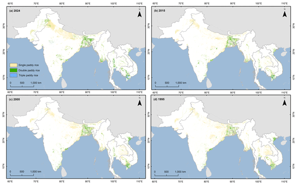
We created long-term, high-resolution maps of rice-growing areas in South and Southeast Asia to show how planting patterns have changed over the past three decades. Using satellite images, we tracked when and how often rice was grown and confirmed the results with more than 23,000 independent samples. The maps closely match national statistics and offer a valuable resource for understanding food production, water use, methane emissions, and climate impacts in this vital region.
Ida Bagus Mandhara Brasika, Pierre Friedlingstein, Stephen Sitch, Michael O'Sullivan, Maria Carolina Duran-Rojas, Emma W. Littleton, Toby R. Marthews, Timothy Hill, Wei Li, Yidi Xu, Jiaxin Zhou, Xiangzhong Luo, Ruiying Zhao, Yuanchao Fan, Dedy Sukmara, Timer Manurung, Masayuki Kondo, Alexander Knohl, Tejaswini Jaajpera, and Lisma Safitri
EGUsphere, https://doi.org/10.5194/egusphere-2026-3689, https://doi.org/10.5194/egusphere-2026-3689, 2026
This preprint is open for discussion and under review for Geoscientific Model Development (GMD).
Short summary
Short summary
Oil palm is a major crop in Indonesia, but climate models often treat it as generic cropland. We developed a new way to represent oil palm in the Joint UK Land Environment Simulator. This improved how the model captures carbon stored and released by oil-palm plantations. The work helps estimate emissions from land-use change more realistically, supporting better understanding of tropical agriculture, deforestation and climate impacts.
Tim Stripp, Zhixuan Guo, Pierre Friedlingstein, Michael O’Sullivan, Stephen Sitch, Ana Bastos, Philippe Ciais, Jefferson Goncalves de Souza, Akihiko Ito, Wei Li, and Lei Ma
EGUsphere, https://doi.org/10.5194/egusphere-2026-3584, https://doi.org/10.5194/egusphere-2026-3584, 2026
Short summary
Short summary
Fire is a key process within the Earth system, yet it is often poorly represented in land carbon cycle models used to estimate how much carbon land ecosystems absorb from the atmosphere. We improved these models by applying long-term burned area data reconstructed from satellite observations. This reduced biases and uncertainty in fire carbon emission estimates and improved estimates of land carbon uptake, implying this method could enhance global and regional carbon budget estimates.
Jincheng Wu, Philippe Ciais, Yuanyuan Huang, Jianing Fang, Pierre Gentine, Yidi Xu, Daniel Goll, Fayong Liu, Xiaomeng Du, Rui Ma, Nan Meng, Mengjie Han, Jinlong Zang, Runda Jiang, and Wei Li
EGUsphere, https://doi.org/10.5194/egusphere-2026-2241, https://doi.org/10.5194/egusphere-2026-2241, 2026
Short summary
Short summary
Predicting land carbon sinks remains a challenge because carbon allocation and turnover are poorly constrained in terrestrial biosphere models. We used a differentiable framework to jointly assimilate daily satellite data and long-term boreal forest growth trajectories. This approach significantly reduced biomass simulation errors. We found that boreal forests sustain biomass through long carbon residence times rather than high allocation rates, making them highly vulnerable to warming.
Lei Zhu, Philippe Ciais, Yitong Yao, Daniel Goll, Sebastiaan Luyssaert, Isabel Martínez Cano, Arthur Fendrich, Laurent Li, Hui Yang, Sassan Saatchi, Ricardo Dalagnol, and Wei Li
Geosci. Model Dev., 18, 4915–4933, https://doi.org/10.5194/gmd-18-4915-2025, https://doi.org/10.5194/gmd-18-4915-2025, 2025
Short summary
Short summary
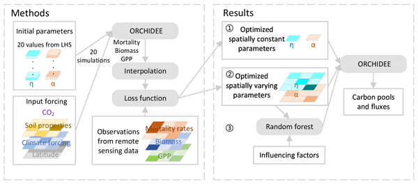
This study enhances the accuracy of modeling the carbon dynamics of the Amazon rainforest by optimizing key model parameters based on satellite data. Using spatially varying parameters for tree mortality and photosynthesis, we improved predictions of biomass, productivity, and tree mortality. Our findings highlight the critical role of wood density and water availability in forest processes, offering insights to use in refining global carbon cycle models.
Zhixuan Guo, Wei Li, Philippe Ciais, Stephen Sitch, Guido R. van der Werf, Simon P. K. Bowring, Ana Bastos, Florent Mouillot, Jiaying He, Minxuan Sun, Lei Zhu, Xiaomeng Du, Nan Wang, and Xiaomeng Huang
Earth Syst. Sci. Data, 17, 3599–3618, https://doi.org/10.5194/essd-17-3599-2025, https://doi.org/10.5194/essd-17-3599-2025, 2025
Short summary
Short summary
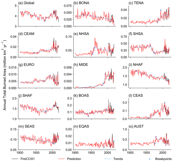
To address the limitations of short time spans in satellite data and spatiotemporal discontinuity in site records, we reconstructed global monthly burned area maps at a 0.5° resolution for 1901–2020 using machine learning models. The global burned area is predicted at 3.46 × 10⁶–4.58 × 10⁶ km² per year, showing a decline from 1901 to 1978, an increase from 1978 to 2008 and a sharper decrease from 2008 to 2020. This dataset provides a benchmark for studies on fire ecology and the carbon cycle.
Binghong Han, Jian Bi, Shengli Tao, Tong Yang, Yongli Tang, Mengshuai Ge, Hao Wang, Zhenong Jin, Jinwei Dong, Zhibiao Nan, and Jin-Sheng He
Earth Syst. Sci. Data, 17, 2933–2952, https://doi.org/10.5194/essd-17-2933-2025, https://doi.org/10.5194/essd-17-2933-2025, 2025
Short summary
Short summary
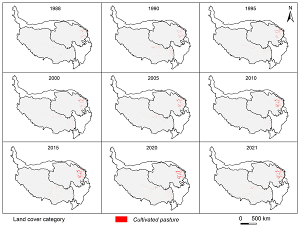
The Tibetan Plateau is an important pastoral area where cultivated pastures play an increasingly important role. However, little is known about the spatial distribution of the cultivated pastures due to the difficulty in distinguishing them from natural grasslands with remote sensing. For the first time, we have mapped the cultivated pastures on the plateau at a resolution of 30 m with decent accuracy. This dataset is valuable to scientists, policymakers, conservationists, and pastoralists.
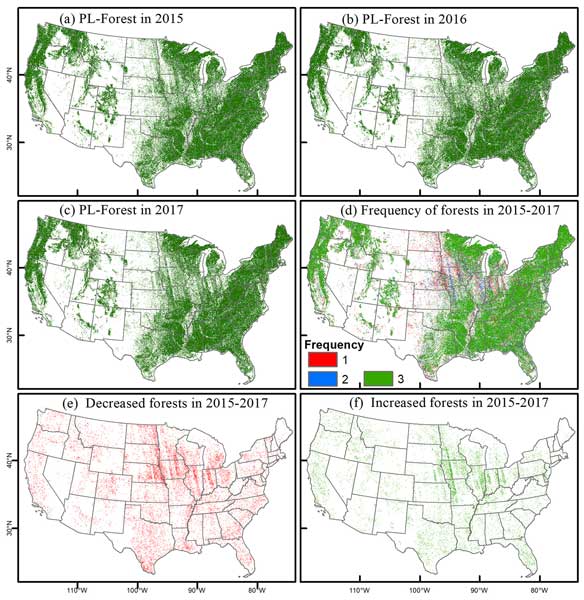
Jie Wang, Xiangming Xiao, Yuanwei Qin, Jinwei Dong, Geli Zhang, Xuebin Yang, Xiaocui Wu, Chandrashekhar Biradar, and Yang Hu
Earth Syst. Sci. Data, 16, 4619–4639, https://doi.org/10.5194/essd-16-4619-2024, https://doi.org/10.5194/essd-16-4619-2024, 2024
Short summary
Short summary
Existing satellite-based forest maps have large uncertainties due to different forest definitions and mapping algorithms. To effectively manage forest resources, timely and accurate annual forest maps at a high spatial resolution are needed. This study improved forest maps by integrating PALSAR-2 and Landsat images. Annual evergreen and non-evergreen forest-type maps were also generated. This critical information supports the Global Forest Resources Assessment.
Qinghang Mei, Zhao Zhang, Jichong Han, Jie Song, Jinwei Dong, Huaqing Wu, Jialu Xu, and Fulu Tao
Earth Syst. Sci. Data, 16, 3213–3231, https://doi.org/10.5194/essd-16-3213-2024, https://doi.org/10.5194/essd-16-3213-2024, 2024
Short summary
Short summary
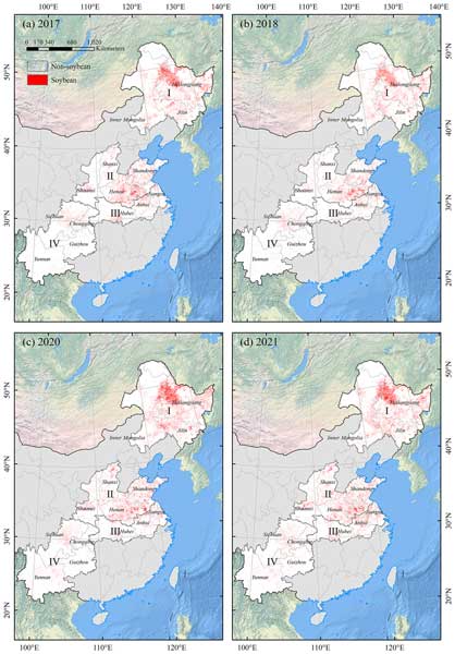
In order to make up for the lack of long-term soybean planting area maps in China, we firstly generated a dataset of soybean planting area with a spatial resolution of 10 m for major producing areas in China from 2017 to 2021 (ChinaSoyArea10m). Compared with existing datasets, ChinaSoyArea10m has higher consistency with census data and further improvement in spatial details. The dataset can provide reliable support for subsequent studies on yield monitoring and food security.
Mengjie Han, Qing Zhao, Xili Wang, Ying-Ping Wang, Philippe Ciais, Haicheng Zhang, Daniel S. Goll, Lei Zhu, Zhe Zhao, Zhixuan Guo, Chen Wang, Wei Zhuang, Fengchang Wu, and Wei Li
Geosci. Model Dev., 17, 4871–4890, https://doi.org/10.5194/gmd-17-4871-2024, https://doi.org/10.5194/gmd-17-4871-2024, 2024
Short summary
Short summary
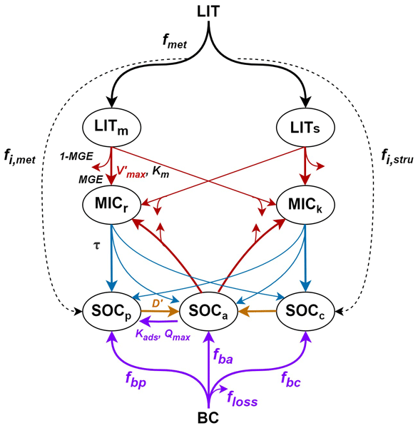
The impact of biochar (BC) on soil organic carbon (SOC) dynamics is not represented in most land carbon models used for assessing land-based climate change mitigation. Our study develops a BC model that incorporates our current understanding of BC effects on SOC based on a soil carbon model (MIMICS). The BC model can reproduce the SOC changes after adding BC, providing a useful tool to couple dynamic land models to evaluate the effectiveness of BC application for CO2 removal from the atmosphere.
Yitong Yao, Philippe Ciais, Emilie Joetzjer, Wei Li, Lei Zhu, Yujie Wang, Christian Frankenberg, and Nicolas Viovy
Earth Syst. Dynam., 15, 763–778, https://doi.org/10.5194/esd-15-763-2024, https://doi.org/10.5194/esd-15-763-2024, 2024
Short summary
Short summary
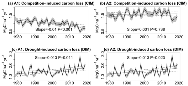
Elevated CO2 concentration (eCO2) is critical for shaping the future path of forest carbon uptake, while uncertainties remain about concurrent carbon loss. Here, we found that eCO2 might amplify competition-induced carbon loss, while the extent of drought-induced carbon loss hinges on the balance between heightened biomass density and water-saving benefits. This is the first time that such carbon loss responses to ongoing climate change have been quantified separately over the Amazon rainforest.
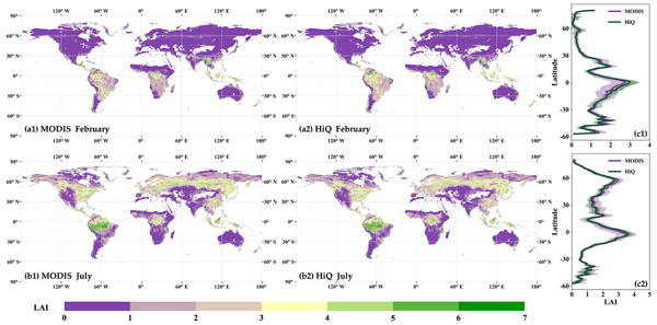
Kai Yan, Jingrui Wang, Rui Peng, Kai Yang, Xiuzhi Chen, Gaofei Yin, Jinwei Dong, Marie Weiss, Jiabin Pu, and Ranga B. Myneni
Earth Syst. Sci. Data, 16, 1601–1622, https://doi.org/10.5194/essd-16-1601-2024, https://doi.org/10.5194/essd-16-1601-2024, 2024
Short summary
Short summary
Variations in observational conditions have led to poor spatiotemporal consistency in leaf area index (LAI) time series. Using prior knowledge, we leveraged high-quality observations and spatiotemporal correlation to reprocess MODIS LAI, thereby generating HiQ-LAI, a product that exhibits fewer abnormal fluctuations in time series. Reprocessing was done on Google Earth Engine, providing users with convenient access to this value-added data and facilitating large-scale research and applications.
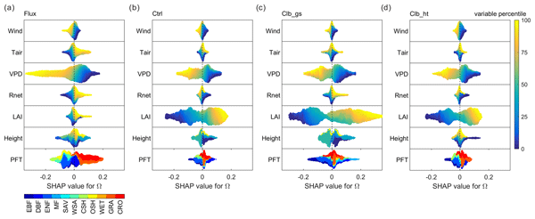
Yuan Zhang, Devaraju Narayanappa, Philippe Ciais, Wei Li, Daniel Goll, Nicolas Vuichard, Martin G. De Kauwe, Laurent Li, and Fabienne Maignan
Geosci. Model Dev., 15, 9111–9125, https://doi.org/10.5194/gmd-15-9111-2022, https://doi.org/10.5194/gmd-15-9111-2022, 2022
Short summary
Short summary
There are a few studies to examine if current models correctly represented the complex processes of transpiration. Here, we use a coefficient Ω, which indicates if transpiration is mainly controlled by vegetation processes or by turbulence, to evaluate the ORCHIDEE model. We found a good performance of ORCHIDEE, but due to compensation of biases in different processes, we also identified how different factors control Ω and where the model is wrong. Our method is generic to evaluate other models.
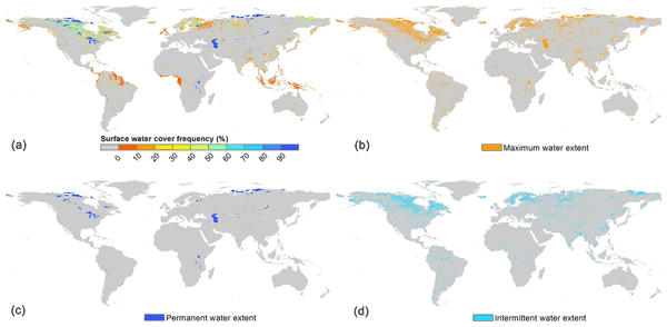
Yang Liu, Ronggao Liu, and Rong Shang
Earth Syst. Sci. Data, 14, 4505–4523, https://doi.org/10.5194/essd-14-4505-2022, https://doi.org/10.5194/essd-14-4505-2022, 2022
Short summary
Short summary
Surface water has been changing significantly with high seasonal variation and abrupt change, making it hard to capture its interannual trend. Here we generated a global annual surface water cover frequency dataset during 2000–2020. The percentage of the time period when a pixel is covered by water in a year was estimated to describe the seasonal dynamics of surface water. This dataset can be used to analyze the interannual variation and change trend of highly dynamic inland water extent.

Xinxin Wang, Xiangming Xiao, Yuanwei Qin, Jinwei Dong, Jihua Wu, and Bo Li
Earth Syst. Sci. Data, 14, 3757–3771, https://doi.org/10.5194/essd-14-3757-2022, https://doi.org/10.5194/essd-14-3757-2022, 2022
Short summary
Short summary
We generated China’s surface water bodies, Large Dams, Reservoirs, and Lakes (China-LDRL) dataset by analyzing all available Landsat imagery in 2019 (19\,338 images) in Google Earth Engine. The dataset provides accurate information on the geographical locations and sizes of surface water bodies, large dams, reservoirs, and lakes in China. The China-LDRL dataset will contribute to the understanding of water security and water resources management in China.
Cited articles
Alencar, A. A. C., Arruda, V. L. S., Silva, W. V. d., Conciani, D. E., Costa, D. P., Crusco, N., Duverger, S. G., Ferreira, N. C., Franca-Rocha, W., Hasenack, H., Martenexen, L. F. M., Piontekowski, V. J., Ribeiro, N. V., Rosa, E. R., Rosa, M. R., dos Santos, S. M. B., Shimbo, J. Z., and Vélez-Martin, E.: Long-Term Landsat-Based Monthly Burned Area Dataset for the Brazilian Biomes Using Deep Learning, Remote Sens.-Basel, 14, 2510, https://doi.org/10.3390/rs14112510 2022.
Andela, N., Morton, D. C., Giglio, L., Paugam, R., Chen, Y., Hantson, S., van der Werf, G. R., and Randerson, J. T.: The Global Fire Atlas of individual fire size, duration, speed and direction, Earth Syst. Sci. Data, 11, 529–552, https://doi.org/10.5194/essd-11-529-2019, 2019.
Archibald, S., Lehmann, C. E. R., Gómez-Dans, J. L., and Bradstock, R. A.: Defining pyromes and global syndromes of fire regimes, P. Natl. Acad. Sci. USA, 110, 6442–6447, 2013.
Artés, T., Oom, D., de Rigo, D., Durrant, T. H., Maianti, P., Libertà, G., and San-Miguel-Ayanz, J.: A global wildfire dataset for the analysis of fire regimes and fire behaviour, Scientific Data, 6, 296, https://doi.org/10.1038/s41597-019-0312-2, 2019.
Balch, J. K., St. Denis, L. A., Mahood, A. L., Mietkiewicz, N. P., Williams, T. M., McGlinchy, J., and Cook, M. C.: FIRED (Fire Events Delineation): An Open, Flexible Algorithm and Database of US Fire Events Derived from the MODIS Burned Area Product (2001–2019), Remote Sens.-Basel, 12, 3498, 2020.
Balch, J. K., Abatzoglou, J. T., Joseph, M. B., Koontz, M. J., Mahood, A. L., McGlinchy, J., Cattau, M. E., and Williams, A. P.: Warming weakens the night-time barrier to global fire, Nature, 602, 442–448, https://doi.org/10.1038/s41586-021-04325-1, 2022.
Barbosa, P. M., Pereira, J. M. C., and Grégoire, J.-M.: Compositing Criteria for Burned Area Assessment Using Multitemporal Low Resolution Satellite Data, Remote Sens. Environ., 65, 38–49, https://doi.org/10.1016/S0034-4257(98)00016-9, 1998.
Beck, P. S. A., Goetz, S. J., Mack, M. C., Alexander, H. D., Jin, Y., Randerson, J. T., and Loranty, M. M.: The impacts and implications of an intensifying fire regime on Alaskan boreal forest composition and albedo, Glob. Change Biol., 17, 2853–2866, https://doi.org/10.1111/j.1365-2486.2011.02412.x, 2011.
Boschetti, L., Roy, D. P., Giglio, L., Huang, H., Zubkova, M., and Humber, M. L.: Global validation of the collection 6 MODIS burned area product, Remote Sens. Environ., 235, 111490, https://doi.org/10.1016/j.rse.2019.111490, 2019.
Brando, P. M., Silvério, D., Maracahipes-Santos, L., Oliveira-Santos, C., Levick, S. R., Coe, M. T., Migliavacca, M., Balch, J. K., Macedo, M. N., Nepstad, D. C., Maracahipes, L., Davidson, E., Asner, G., Kolle, O., and Trumbore, S.: Prolonged tropical forest degradation due to compounding disturbances: Implications for CO2 and H2O fluxes, Glob. Change Biol., 25, 2855–2868, https://doi.org/10.1111/gcb.14659, 2019.
Buonanduci, M. S., Donato, D. C., Halofsky, J. S., Kennedy, M. C., and Harvey, B. J.: Few large or many small fires: Using spatial scaling of severe fire to quantify effects of fire-size distribution shifts, Ecosphere, 15, e4875, https://doi.org/10.1002/ecs2.4875, 2024.
Chuvieco, E., Ventura, G., Martín, M. P., and Gómez, I.: Assessment of multitemporal compositing techniques of MODIS and AVHRR images for burned land mapping, Remote Sens. Environ., 94, 450–462, https://doi.org/10.1016/j.rse.2004.11.006, 2005.
Chuvieco, E., Mouillot, F., van der Werf, G. R., San Miguel, J., Tanasse, M., Koutsias, N., García, M., Yebra, M., Padilla, M., Gitas, I., Heil, A., Hawbaker, T. J., and Giglio, L.: Historical background and current developments for mapping burned area from satellite Earth observation, Remote Sens. Environ., 225, 45–64, https://doi.org/10.1016/j.rse.2019.02.013, 2019.
Cova, G., Kane, V. R., Prichard, S., North, M., and Cansler, C. A.: The outsized role of California's largest wildfires in changing forest burn patterns and coarsening ecosystem scale, Forest Ecol. Manag., 528, 120620, https://doi.org/10.1016/j.foreco.2022.120620, 2023.
Duan, Q., Liu, R., Chen, J., Wei, X., Liu, Y., and Zou, X.: Burned area detection from a single satellite image using an adaptive thresholds algorithm, Int. J. Digit. Earth, 17, 2376275, https://doi.org/10.1080/17538947.2024.2376275, 2024.
Feng, L. and Wang, X.: Quantifying Cloud-Free Observations from Landsat Missions: Implications for Water Environment Analysis, J. Remote Sens., 4, 0110, https://doi.org/10.34133/remotesensing.0110, 2024.
Flores-Anderson, A. I., Cardille, J., Azad, K., Cherrington, E., Zhang, Y., and Wilson, S.: Spatial and Temporal Availability of Cloud-free Optical Observations in the Tropics to Monitor Deforestation, Scientific Data, 10, 550, https://doi.org/10.1038/s41597-023-02439-x, 2023.
Francini, S., Hermosilla, T., Coops, N. C., Wulder, M. A., White, J. C., and Chirici, G.: An assessment approach for pixel-based image composites, ISPRS J. Photogramm., 202, 1–12, https://doi.org/10.1016/j.isprsjprs.2023.06.002, 2023.
Franquesa, M., Vanderhoof, M. K., Stavrakoudis, D., Gitas, I. Z., Roteta, E., Padilla, M., and Chuvieco, E.: Development of a standard database of reference sites for validating global burned area products, Earth Syst. Sci. Data, 12, 3229–3246, https://doi.org/10.5194/essd-12-3229-2020, 2020.
Giglio, L., Boschetti, L., Roy, D. P., Humber, M. L., and Justice, C. O.: The Collection 6 MODIS burned area mapping algorithm and product, Remote Sens. Environ., 217, 72–85, https://doi.org/10.1016/j.rse.2018.08.005, 2018.
Godoy, E., Adorno, B. F. C. B., da Silva, B. D., Corrêa, W., Barbosa, V. M., Piratelli, A. J., Ribeiro, M. C., and Hasui, É.: Fire refugia under threat: How increasing pyrodiversity reduces species richness in unburned forests, Forest Ecol. Manag., 585, 122673, https://doi.org/10.1016/j.foreco.2025.122673, 2025.
Hansen, M. C., Potapov, P. V., Moore, R., Hancher, M., Turubanova, S. A., Tyukavina, A., Thau, D., Stehman, S. V., Goetz, S. J., Loveland, T. R., Kommareddy, A., Egorov, A., Chini, L., Justice, C. O., and Townshend, J. R. G.: High-Resolution Global Maps of 21st-Century Forest Cover Change, Science, 342, 850–854, https://doi.org/10.1126/science.1244693, 2013.
Hantson, S., Pueyo, S., and Chuvieco, E.: Global fire size distribution is driven by human impact and climate, Global Ecol. Biogeogr., 24, 77–86, https://doi.org/10.1111/geb.12246, 2015.
Harris, N. L., Brown, S., Hagen, S. C., Saatchi, S. S., Petrova, S., Salas, W., Hansen, M. C., Potapov, P. V., and Lotsch, A.: Baseline Map of Carbon Emissions from Deforestation in Tropical Regions, Science, 336, 1573–1576, https://doi.org/10.1126/science.1217962, 2012.
Hawbaker, T. J., Vanderhoof, M. K., Schmidt, G. L., Beal, Y. J., Picotte, J. J., Takacs, J. D., Falgout, J. T., and Dwyer, J. L.: The Landsat Burned Area algorithm and products for the conterminous United States, Remote Sens. Environ., 244, 111801, https://doi.org/10.1016/j.rse.2020.111801, 2020a.
Hawbaker, T. J., Vanderhoof, M. K., Schmidt, G. L., Beal, Y., Picotte, J. J., Takacs, J. D., Falgout, J. T., and Dwyer, J. L.: The Landsat Burned Area products for the conterminous United States (ver. 3.0, March 2022), U.S. Geological Survey data release, https://doi.org/10.5066/P9QKHKTQ, 2020b.
Hermosilla, T., Wulder, M. A., White, J. C., and Coops, N. C.: Prevalence of multiple forest disturbances and impact on vegetation regrowth from interannual Landsat time series (1985–2015), Remote Sens. Environ., 233, 111403, https://doi.org/10.1016/j.rse.2019.111403, 2019.
Hislop, S., Jones, S., Soto-Berelov, M., Skidmore, A., Haywood, A., and Nguyen, T. H.: Using Landsat Spectral Indices in Time-Series to Assess Wildfire Disturbance and Recovery, Remote Sens.-Basel, 10, 460, https://doi.org/10.3390/rs10030460, 2018.
Huang, C., Goward, S. N., Masek, J. G., Thomas, N., Zhu, Z., and Vogelmann, J. E.: An automated approach for reconstructing recent forest disturbance history using dense Landsat time series stacks, Remote Sens. Environ., 114, 183–198, https://doi.org/10.1016/j.rse.2009.08.017, 2010.
Iglesias, V., Balch, J. K., and Travis, W. R.: U. S. fires became larger, more frequent, and more widespread in the 2000s, Science Advances, 8, eabc0020, https://doi.org/10.1126/sciadv.abc0020, 2022.
Kennedy, R. E., Yang, Z., and Cohen, W. B.: Detecting trends in forest disturbance and recovery using yearly Landsat time series: 1. LandTrendr – Temporal segmentation algorithms, Remote Sens. Environ., 114, 2897–2910, https://doi.org/10.1016/j.rse.2010.07.008, 2010.
Liu, R.: Compositing the Minimum NDVI for MODIS Data, IEEE T. Geosci. Remote, 55, 1396–1406, https://doi.org/10.1109/TGRS.2016.2623746, 2017.
Liu, R.: A Global 30 m Landsat-based Dataset of Forest Fire Patches (GlobMap FFP v1.0) from 1984–2022, Zenodo [data set], https://doi.org/10.5281/zenodo.17638167, 2025.
Liu, R. and Liu, Y.: GLOBMAP FTC: a global annual fractional tree cover dataset since 2000 (Version Version 1.0), Zenodo [data set], https://doi.org/10.5281/zenodo.10589730, 2024.
Liu, Y., Liu, R., Chen, J., Wei, X., Qi, L., and Zhao, L.: A global annual fractional tree cover dataset during 2000–2021 generated from realigned MODIS seasonal data, Scientific Data, 11, 832, https://doi.org/10.1038/s41597-024-03671-9, 2024.
Long, T., Zhang, Z., He, G., Jiao, W., Tang, C., Wu, B., Zhang, X., Wang, G., and Yin, R.: 30 m Resolution Global Annual Burned Area Mapping Based on Landsat Images and Google Earth Engine, Remote Sens.-Basel, 11, 489, https://doi.org/10.3390/rs11050489, 2019.
Lv, Q., Chen, Z., Wu, C., Peñuelas, J., Fan, L., Su, Y., Yang, Z., Li, M., Gao, B., Hu, J., Zhang, C., Fu, Y., and Wang, Q.: Increasing severity of large-scale fires prolongs recovery time of forests globally since 2001, Nature Ecology and Evolution, 9, 980–992, https://doi.org/10.1038/s41559-025-02683-x, 2025.
McKenna, P., Phinn, S., and Erskine, P. D.: Fire Severity and Vegetation Recovery on Mine Site Rehabilitation Using WorldView-3 Imagery, Fire, 1, 22, https://doi.org/10.3390/fire1020022, 2018.
Meddens, A. J. H., Kolden, C. A., and Lutz, J. A.: Detecting unburned areas within wildfire perimeters using Landsat and ancillary data across the northwestern United States, Remote Sens. Environ., 186, 275–285, https://doi.org/10.1016/j.rse.2016.08.023, 2016.
Miettinen, J. and Liew, S. C.: Comparison of multitemporal compositing methods for burnt area detection in Southeast Asian conditions, Int. J. Remote Sens., 29, 1075–1092, https://doi.org/10.1080/01431160701281031, 2008.
Minor, J., Falk, D. A., and Barron-Gafford, G. A.: Fire Severity and Regeneration Strategy Influence Shrub Patch Size and Structure Following Disturbance, Forests, 8, 221, https://doi.org/10.3390/f8070221, 2017.
Miranda, A., Mentler, R., Moletto-Lobos, Í., Alfaro, G., Aliaga, L., Balbontín, D., Barraza, M., Baumbach, S., Calderón, P., Cárdenas, F., Castillo, I., Contreras, G., de la Barra, F., Galleguillos, M., González, M. E., Hormazábal, C., Lara, A., Mancilla, I., Muñoz, F., Oyarce, C., Pantoja, F., Ramírez, R., and Urrutia, V.: The Landscape Fire Scars Database: mapping historical burned area and fire severity in Chile, Earth Syst. Sci. Data, 14, 3599–3613, https://doi.org/10.5194/essd-14-3599-2022, 2022a.
Miranda, A., Mentler, R., Moletto Lobos, I., Alfaro, G., Aliaga, L., Balbontín, D., Barraza, M., Baumbach, S., Calderón, P., Cardenas, F., Castillo, I., Gonzalo, C., de la Barra, F., Galleguillos, M., Gonzalez, M., Hormazabal, C., Lara, A., Mancilla, I., Muñoz, F., Oyarce, C., Pantoja, F., Ramirez, R., and Urrutia, V.: Fire Scars: remotely sensed historical burned area and fire severity in Chile between 1984–2018, PANGAEA [data set], https://doi.org/10.1594/PANGAEA.941127, 2022b.
Myroniuk, V., Kutia, M., J. Sarkissian, A., Bilous, A., and Liu, S.: Regional-Scale Forest Mapping over Fragmented Landscapes Using Global Forest Products and Landsat Time Series Classification, Remote Sens.-Basel, 12, 187, https://doi.org/10.3390/rs12010187 2020.
Nair, V. and Hinton, G. E.: Rectified linear units improve restricted boltzmann machines, Proceedings of the 27th International Conference on International Conference on Machine Learning, Haifa, Israel, https://dl.acm.org/doi/10.5555/3104322.3104425 (last access: 17 August 2026), 2010.
Otón, G., Ramo, R., Lizundia-Loiola, J., and Chuvieco, E.: Global Detection of Long-Term (1982–2017) Burned Area with AVHRR-LTDR Data, Remote Sens., 11, 2079, https://doi.org/10.3390/rs11182079, 2019.
Padilla, M., Stehman, S. V., Ramo, R., Corti, D., Hantson, S., Oliva, P., Alonso-Canas, I., Bradley, A. V., Tansey, K., Mota, B., Pereira, J. M., and Chuvieco, E.: Comparing the accuracies of remote sensing global burned area products using stratified random sampling and estimation, Remote Sens. Environ., 160, 114–121, https://doi.org/10.1016/j.rse.2015.01.005, 2015.
Pérez-Cabello, F., Montorio, R., and Alves, D. B.: Remote sensing techniques to assess post-fire vegetation recovery, Current Opinion in Environmental Science and Health, 21, 100251, https://doi.org/10.1016/j.coesh.2021.100251, 2021.
Pugh, T. A. M., Arneth, A., Kautz, M., Poulter, B., and Smith, B.: Important role of forest disturbances in the global biomass turnover and carbon sinks, Nat. Geosci., 12, 730–735, https://doi.org/10.1038/s41561-019-0427-2, 2019.
Qiu, S., Zhu, Z., Olofsson, P., Woodcock, C. E., and Jin, S.: Evaluation of Landsat image compositing algorithms, Remote Sens. Environ., 285, 113375, https://doi.org/10.1016/j.rse.2022.113375, 2023.
Ramo, R., Roteta, E., Bistinas, I., van Wees, D., Bastarrika, A., Chuvieco, E., and van der Werf, G. R.: African burned area and fire carbon emissions are strongly impacted by small fires undetected by coarse resolution satellite data, P. Natl. Acad. Sci. USA, 118, 1–7, https://doi.org/10.1073/pnas.2011160118, 2021.
Robinson, J. M.: Fire from space: Global fire evaluation using infrared remote sensing, Int. J. Remote Sens., 12, 3–24, https://doi.org/10.1080/01431169108929628, 1991.
Roteta, E., Bastarrika, A., Padilla, M., Storm, T., and Chuvieco, E.: Development of a Sentinel-2 burned area algorithm: Generation of a small fire database for sub-Saharan Africa, Remote Sens. Environ., 222, 1–17, https://doi.org/10.1016/j.rse.2018.12.011, 2019.
Scholten, R. C., Coumou, D., Luo, F., and Veraverbeke, S.: Early snowmelt and polar jet dynamics co-influence recent extreme Siberian fire seasons, Science, 378, 1005–1009, https://doi.org/10.1126/science.abn4419, 2022.
Senf, C. and Seidl, R.: European forest disturbance maps (Version 1.0.0), Zenodo [data set], https://doi.org/10.5281/zenodo.3924381, 2020.
Senf, C. and Seidl, R.: Storm and fire disturbances in Europe: Distribution and trends, Glob. Change Biol., 27, 3605–3619, https://doi.org/10.1111/gcb.15679, 2021a.
Senf, C. and Seidl, R.: Mapping the forest disturbance regimes of Europe, Nature Sustainability, 4, 63–70, https://doi.org/10.1038/s41893-020-00609-y, 2021b.
Sommers, M. and Flannigan, M. D.: Green islands in a sea of fire: the role of fire refugia in the forests of Alberta, Environ. Rev., 30, 402–417, https://doi.org/10.1139/er-2021-0115, 2022.
Sulla-Menashe, D., Gray, J. M., Abercrombie, S. P., and Friedl, M. A.: Hierarchical mapping of annual global land cover 2001 to present: The MODIS Collection 6 Land Cover product, Remote Sens. Environ., 222, 183–194, https://doi.org/10.1016/j.rse.2018.12.013, 2019.
Turner, M. G.: Disturbance and landscape dynamics in a changing world, Ecology, 91, 2833–2849, https://doi.org/10.1890/10-0097.1, 2010.
Turner, M. G., Romme, W. H., Gardner, R. H., and Hargrove, W. W.: Effects of fire size and pattern on early succession in Yellowstone National Park, Ecol. Monogr., 67, 411–433, https://doi.org/10.1890/0012-9615(1997)067[0411:EOFSAP]2.0.CO;2, 1997.
Tyukavina, A., Potapov, P., Hansen, M. C., Pickens, A. H., Stehman, S. V., Turubanova, S., Parker, D., Zalles, V., Lima, A., Kommareddy, I., Song, X.-P., Wang, L., and Harris, N.: Global Trends of Forest Loss Due to Fire From 2001–2019, Frontiers in Remote Sensing, 3, https://doi.org/10.3389/frsen.2022.825190, 2022.
van Wees, D., van der Werf, G. R., Randerson, J. T., Andela, N., Chen, Y., and Morton, D. C.: The role of fire in global forest loss dynamics, Glob. Change Biol., 27, 2377–2391, https://doi.org/10.1111/gcb.15591, 2021.
Veraverbeke, S., Rogers, B. M., Goulden, M. L., Jandt, R. R., Miller, C. E., Wiggins, E. B., and Randerson, J. T.: Lightning as a major driver of recent large fire years in North American boreal forests, Nat. Clim. Change, 7, 529–534, https://doi.org/10.1038/nclimate3329, 2017.
White, J. C., Wulder, M. A., Hobart, G. W., Luther, J. E., Hermosilla, T., Griffiths, P., Coops, N. C., Hall, R. J., Hostert, P., Dyk, A., and Guindon, L.: Pixel-Based Image Compositing for Large-Area Dense Time Series Applications and Science, Can. J. Remote Sens., 40, 192–212, https://doi.org/10.1080/07038992.2014.945827, 2014.
Zheng, B., Ciais, P., Chevallier, F., Chuvieco, E., Chen, Y., and Yang, H.: Increasing forest fire emissions despite the decline in global burned area, Science Advances, 7, eabh2646, https://doi.org/10.1126/sciadv.abh2646, 2021.
Short summary
Understanding how forest fires reshape landscapes requires information not only on where fires occur, but also on the size, shape, and spatial organization of fire patches. We created a global 30 m dataset of forest fire patches spanning 1984–2022 using the Landsat satellite archive. Including nearly 12 million fire patches, this dataset facilitates ecological research at regional to global scales by characterizing fire patch structure and spatial organization over time.
Understanding how forest fires reshape landscapes requires information not only on where fires...


Altmetrics
Final-revised paper
Preprint