Articles | Volume 14, issue 9
https://doi.org/10.5194/essd-14-4231-2022
© Author(s) 2022. This work is distributed under
the Creative Commons Attribution 4.0 License.
https://doi.org/10.5194/essd-14-4231-2022
© Author(s) 2022. This work is distributed under
the Creative Commons Attribution 4.0 License.
High-resolution streamflow and weather data (2013–2019) for seven small coastal watersheds in the northeast Pacific coastal temperate rainforest, Canada
Maartje C. Korver
CORRESPONDING AUTHOR
Hakai Institute, Tula Foundation, Heriot Bay, BC V0P 1H0, Canada
current address: Department of Geography, McGill University, Montréal, QC H3A 0B9, Canada
Emily Haughton
Hakai Institute, Tula Foundation, Heriot Bay, BC V0P 1H0, Canada
William C. Floyd
CORRESPONDING AUTHOR
Ministry of Forests, Lands, and Natural Resource Operations, Nanaimo, BC V9T 6E9, Canada
Department of Geography, Vancouver Island University, Nanaimo, BC V9R 5S5, Canada
Ian J. W. Giesbrecht
Hakai Institute, Tula Foundation, Heriot Bay, BC V0P 1H0, Canada
School of Resource and Environmental Management, Simon Fraser
University, Burnaby, BC V5A 1S6, Canada
Related authors
Bernhard Lehner, Mira Anand, Etienne Fluet-Chouinard, Florence Tan, Filipe Aires, George H. Allen, Philippe Bousquet, Josep G. Canadell, Nick Davidson, Meng Ding, C. Max Finlayson, Thomas Gumbricht, Lammert Hilarides, Gustaf Hugelius, Robert B. Jackson, Maartje C. Korver, Liangyun Liu, Peter B. McIntyre, Szabolcs Nagy, David Olefeldt, Tamlin M. Pavelsky, Jean-Francois Pekel, Benjamin Poulter, Catherine Prigent, Jida Wang, Thomas A. Worthington, Dai Yamazaki, Xiao Zhang, and Michele Thieme
Earth Syst. Sci. Data, 17, 2277–2329, https://doi.org/10.5194/essd-17-2277-2025, https://doi.org/10.5194/essd-17-2277-2025, 2025
Short summary
Short summary
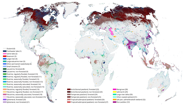
The Global Lakes and Wetlands Database (GLWD) version 2 distinguishes a total of 33 non-overlapping wetland classes, providing a static map of the world’s inland surface waters. It contains cell fractions of wetland extents per class at a grid cell resolution of ~500 m. The total combined extent of all classes including all inland and coastal waterbodies and wetlands of all inundation frequencies – that is, the maximum extent – covers 18.2 × 10⁶ km2, equivalent to 13.4 % of total global land area.
Bernhard Lehner, Mira Anand, Etienne Fluet-Chouinard, Florence Tan, Filipe Aires, George H. Allen, Philippe Bousquet, Josep G. Canadell, Nick Davidson, Meng Ding, C. Max Finlayson, Thomas Gumbricht, Lammert Hilarides, Gustaf Hugelius, Robert B. Jackson, Maartje C. Korver, Liangyun Liu, Peter B. McIntyre, Szabolcs Nagy, David Olefeldt, Tamlin M. Pavelsky, Jean-Francois Pekel, Benjamin Poulter, Catherine Prigent, Jida Wang, Thomas A. Worthington, Dai Yamazaki, Xiao Zhang, and Michele Thieme
Earth Syst. Sci. Data, 17, 2277–2329, https://doi.org/10.5194/essd-17-2277-2025, https://doi.org/10.5194/essd-17-2277-2025, 2025
Short summary
Short summary
The Global Lakes and Wetlands Database (GLWD) version 2 distinguishes a total of 33 non-overlapping wetland classes, providing a static map of the world’s inland surface waters. It contains cell fractions of wetland extents per class at a grid cell resolution of ~500 m. The total combined extent of all classes including all inland and coastal waterbodies and wetlands of all inundation frequencies – that is, the maximum extent – covers 18.2 × 10⁶ km2, equivalent to 13.4 % of total global land area.
Krysten Rutherford, Laura Bianucci, and William Floyd
Geosci. Model Dev., 17, 6083–6104, https://doi.org/10.5194/gmd-17-6083-2024, https://doi.org/10.5194/gmd-17-6083-2024, 2024
Short summary
Short summary
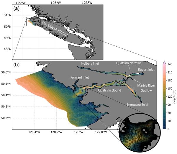
Nearshore ocean models often lack complete information about freshwater fluxes due to numerous ungauged rivers and streams. We tested a simple rain-based hydrological model as inputs into an ocean model of Quatsino Sound, Canada, with the aim of improving the representation of the land–ocean connection in the nearshore model. Through multiple tests, we found that the performance of the ocean model improved when providing 60 % or more of the freshwater inputs from the simple runoff model.
Laura Bianucci, Jennifer M. Jackson, Susan E. Allen, Maxim V. Krassovski, Ian J. W. Giesbrecht, and Wendy C. Callendar
Ocean Sci., 20, 293–306, https://doi.org/10.5194/os-20-293-2024, https://doi.org/10.5194/os-20-293-2024, 2024
Short summary
Short summary
While the deeper waters in the coastal ocean show signs of climate-change-induced warming and deoxygenation, some fjords can keep cool and oxygenated waters in the subsurface. We use a model to investigate how these subsurface waters created during winter can linger all summer in Bute Inlet, Canada. We found two main mechanisms that make this fjord retentive: the typical slow subsurface circulation in such a deep, long fjord and the further speed reduction when the cold waters are present.
Cited articles
Alaback, P. B.: Biodiversity patterns in relation to climate in the temperate
rainforests of North America, in:
High latitude rain forests of the west coast of the Americas: climate,
hydrology, ecology and conservation, edited by: Lawford, R., Alaback, P. B., and Fuentes, E. R., Ecological studies, Springer, Berlin, 113, 105–133,
1996.
Arriola, S. G. and Holmes, K.: Hakai Terrain Relief, Hakai Geospatial data, ArcGIS Online [data set],
http://hakai.maps.arcgis.com/home/item.html?id=711527c3469a4012bd0b25983de4b3d9 (last access: 16 September 2020),
2017.
Banner, A., LePage, P., Moran, J., and de Groot, A. (Eds.): The HyP3 Project:
pattern, process, and productivity in hypermaritime forests of coastal
British Columbia – a synthesis of 7-year results, B.C. Min. For., Res. Br.,
Victoria, B.C. Spec. Rep., 10, https://www.for.gov.bc.ca/hfd/pubs/docs/srs/Srs10.htm (last access: 10 January 2021), 2005.
Bidlack, A. L., Bisbing, S. M., Buma, B. J.,
Diefenderfer, H. L., Fellman, J. B., Floyd, W. C., Giesbrecht, I., Lally, A.,
Lertzman, K. P., Perakis, S. S., Butman, D. E., D'Amore, D. V., Fleming, S. W.,
Hood, E. W., Hunt, B. P. V., Kiffney, P. M., McNicol, G., Menounos, B., and Tank,
S. E.: Climate-Mediated Changes to Linked Terrestrial and Marine Ecosystems
across the Northeast Pacific Coastal Temperate Rainforest Margin,
BioScience, 71, 581–595, https://doi.org/10.1093/biosci/biaa171, 2021.
Cohn, T. A., Kiang J. E., and Mason Jr., R. R.: Estimating Discharge
Measurement Uncertainty Using the Interpolated Variance Estimator, American
Society of Civil Engineers, https://doi.org/10.1061/(ASCE)HY.1943-7900.0000695, 2013.
Coxon, G., Freer, J., Westerberg, I. K., Wagener, T., Woods, R., and Smith,
P. J.: A novel framework for discharge uncertainty quantification applied to
500 UK gauging stations, Water Resour. Res., 51, 5531–5546,
https://doi.org/10.1002/2014WR016532, 2015.
Déry, S. J., Stahl, K., Moore, R. D., Whitfield, P. H., Menounos, B.,
and Burford, J. E.: Detection of runoff timing changes in pluvial, nival,
and glacial rivers of western Canada, Water Resour. Res., 45, W04426,
https://doi.org/10.1029/2008WR006975, 2009.
Domeneghetti, A., Castellarin, A., and Brath, A.: Assessing rating-curve uncertainty and its effects on hydraulic model calibration, Hydrol. Earth Syst. Sci., 16, 1191–1202, https://doi.org/10.5194/hess-16-1191-2012, 2012.
Ecotrust, Pacific GIS, & Conservation International: Original
distribution of the Coastal Temperate Rain Forest, in: The rainforests of
home: An atlas of people and place, Interrain, Portland, Oregon, https://ecotrust.org/wp-content/uploads/Rainforests_of_Home.pdf (last access: 15 February 2021), 1995.
Fang, X., Hou, X., Li, X., Hou W., Nakaoka, M., and Yu X.: Ecological
connectivity between land and sea: a review. Ecol Res 33, 51–61,
https://doi.org/10.1007/s11284-017-1549-x, 2018.
Fiedler, F. R.: Simple, practical method for determining station weights
using Thiessen polygons and isohyetal maps, J. Hydrol.
Eng., 8, 219–221, https://doi.org/10.1061/(ASCE)1084-0699(2003)8:4(219), 2003.
Giesbrecht, I. J. W., Floyd, W. C., Tank, S. E., Lertzman, K. P., Hunt, B.
P. V., Korver, M. C., and Del Bel Belluz, J.: The Kwakshua
Watersheds Observatory, central coast of British Columbia, Canada,
Hydrol. Process., 35, e14198, https://doi.org/10.1002/hyp.14198, 2021.
Giesbrecht, I. J. W., Tank, S. E., Frazer, G. W., Hood, E., Gonzalez
Arriola, S. G., Butman, D. E., D'Amore, D.V., Hutchinson, D., Bidlack, A., and
Lertzman, K. P.: Watershed classification predicts streamflow regime and
organic carbon dynamics in the Northeast Pacific Coastal Temperate
Rainforest, Global Biogeochem. Cy., 36, e2021GB007047,
https://doi.org/10.1029/2021GB007047, 2022.
Gonzalez Arriola, S., Frazer, G. W., and Giesbrecht, I.: LiDAR-derived
watersheds and their metrics for Calvert Island, Hakai Data Catalogue [data set],
https://doi.org/10.21966/1.15311, 2015.
Gonzalez Arriola, S., Giesbrecht, I. J. W., Biles, F. E., and D'Amore, D.
V.: Watersheds of the northern Pacific coastal temperate rainforest margin, Hakai Data Catalogue
[data set], https://doi.org/10.21966/1.715755, 2018.
Green, R. N.: Reconnaissance level terrestrial ecosystem mapping of priority
landscape units of the coast EBM planning area: Phase 3, Prepared for
British Columbia Ministry Forests, Lands and Natural Resource Ops.,
Blackwell and Associates, Vancouver, Canada, 2014.
Haughton E.: wx-tools v1, Zenodo [code], https://doi.org/10.5281/zenodo.7044487, 2022.
Henshaw, D. and Martin, M.: Sensor Data Quality,
https://wiki.esipfed.org/Sensor_Data_Quality (last access: 1 April 2021), 2014.
Hill, D. F., Ciavola, S. J., Etherington, L., and Klaar, M. J.: Estimation of
freshwater runoff into Glacier Bay, Alaska and incorporation into a tidal
circulation model, Estuar. Coast. Shelf Sci., 82, 95–107,
https://doi.org/10.1016/j.ecss.2008.12.019, 2009.
Hoffman, K. M., Gavin, D. G., and Starzomski, B. M.: Seven hundred years of
human-driven and climate-influenced fire activity in a British Columbia
coastal temperate rainforest, R. Soc. Open Scie., 3, 160608160608, https://doi.org/10.1098/rsos.160608,
2016.
Hoffman, K. M., Starzomski, B. M., Lertzman, K. P., Giesbrecht, I. J. W.,
and Trant, A. J.: Old-growth forest structure in a low-productivity
hypermaritime rainforest in coastal British Columbia, Canada, Ecosphere,
12, 1–15, https://doi.org/10.1002/ecs2.3513, 2021.
ISO 748:2007: Hydrometery – Measurement of liquid flow in open channels
using current-meters or floats, International Organization for
Standardization, Geneva Switzerland,
https://www.iso.org/standard/37573.html (last access: 1 June 2018), 2007.
Jakob, M., Holm, K., Lange, O., and Schwab, J. W.: Hydrometeorological
thresholds for landslide initiation and forest operation shutdowns on the
north coast of British Columbia, Landslides, 3, 228–238,
https://doi.org/10.1007/s10346-006-0044-1, 2006.
Korver, M. C.: RatingCurve v1.0, Zenodo [code], https://doi.org/10.5281/zenodo.7043719, 2022.
Korver, M. C., van Meerveld, H.,J., Floyd, W.,C., and Waterloo, M. J.: Uncertainty
analysis of stage-discharge rating curves for seven rivers at Calvert
Island, British Columbia, Canada, VU University Amsterdam and Hakai
Institute, MSc thesis, https://doi.org/10.21966/1.715699, 2018.
Korver, M., Haughton, E., Floyd, B., and Giesbrecht, I.: High-resolution
hydrometeorological data from seven small coastal watersheds, British
Columbia, Canada, 2013–2019, Hakai Data Catalogue [data set], https://doi.org/10.21966/J99C-9C14, 2021.
Kranabetter, J. M., LePage, P., and Banner, A.: Management and productivity of
cedar-hemlock-salal scrub forests on the north coast of British Columbia,
Forest Ecol. Manage., 308, 161–168,
https://doi.org/10.1016/j.foreco.2013.07.058, 2013.
Legates, D. R., Yang, D., Quiring, S. M., Freeman, K., and Bogart, T.: Bias adjustments to Arctic precipitation: A comparison of daily versus monthly adjustments. Extended abstract of paper presented at the 8th Conference on Polar
Meteorology and Oceanography, San Diego, CA,
http://ams.confex.com/ams/pdfpapers/86285.pdf (last access: 21 November 2021), January 2005.
Lotze, H. K., Lenihan, H. S., Bourque, B. J., Bradbury, R. H., Cooke, R. G., Kay,
M. C., Kidwell, S. M., Kirby, M. X., Peterson, C. H., and Jackson, J. B.:
Depletion, degradation, and recovery potential of estuaries and coastal
seas, Science, 312:1806–1809, https://doi.org/10.1126/science.1128035, 2006.
Lu, Y., Yuan, J., Lu, X., Su, C., Zhang, Y., Wang, C., Cao, X., Li, Q., Su,
J., Ittekkot, V., Garbutt, R. A., Bush, S., Fletcher, S., Wagey, T., Kachur,
A., and Sweijd, N.: Major threats of pollution and climate change to global
coastal ecosystems and enhanced management for sustainability, Environ.
Pollut., 239, 670–680, https://doi.org/10.1016/j.envpol.2018.04.016, 2018.
McLaren, D., Rahemtulla, F., Gitla, E. W., and Fedje, D.: Prerogatives, sea level, and the strength of persistent places: archaeological evidence for long-term occupation of the Central Coast of British Columbia, BC Studies, Vancouver Iss., 187, 155–192, 2015.
McLaren, D., Fedje, D., Dyck, A., Mackie, Q., Gauvreau, A., and Cohen, J.:
Terminal Pleistocene epoch human footprints from the Pacific coast of
Canada, PLOS ONE, 13, e0193522, https://doi.org/10.1371/journal.pone.0193522, 2018.
McNicol, G., Bulmer, C., D'Amore, D., Sanborn, P., Saunders, S., Giesbrecht,
I., Gonzales Arriola, S., Bidlack, A., Butman, D., and Buma, B.: Large,
climate-sensitive soil carbon stocks mapped with pedology-informed machine
learning in the North Pacific coastal temperate rainforest, Environ. Res.
Lett., 14, 014004, https://doi.org/10.1088/1748-9326/aaed52, 2019.
Menounos, B., Hugonnet, R., Shean, D., Gardner, A., Howat, I., Berthier, E.,
Pelto, B., Tennant, C., Shea, J., Noh, M. J., Brun, F., and Dehecq, A.:
Heterogeneous changes in western North American glaciers linked to decadal
variability in zonal wind strength, Geophys. Res. Lett., 46, 200–209, https://doi.org/10.1029/2018GL080942, 2019.
Moore, R. D.: Introduction to salt dilution gauging for streamflow
measurement Part I, Streamline Watershed Management Bulletin, 7, 20–23,
2004a.
Moore, R. D.: Introduction to salt dilution gauging for streamflow
measurement Part II: Constant-rate injection, Streamline Watershed
Management Bulletin, 8, 11–15, 2004b.
Moore, R. D.: Introduction to salt dilution gauging for streamflow
measurement part III: Slug injection using salt in solution, Streamline
Watershed Management Bulletin, 8, 1–6, 2005.
Moore, R. D., Trubilowicz, J., and Buttle, J.: Prediction of Streamflow Regime
and Annual Runoff for Ungauged Basins Using a Distributed Monthly Water
Balance Model, J. Ame. Water Resour. As.,
48, 32–42, https://doi.org/10.1111/j.1752-1688.2011.00595.x, 2012.
Morrison, J., Foreman, M. G. G., and Masson, D.: A Method for Estimating
Monthly Freshwater Discharge Affecting British Columbia Coastal Waters,
Atmos.-Ocean, 50, 1–8, https://doi.org/10.1080/07055900.2011.637667, 2012.
Oliver, A. A., Tank, S. E., Giesbrecht, I., Korver, M. C., Floyd, W. C., Sanborn, P., Bulmer, C., and Lertzman, K. P.: A global hotspot for dissolved organic carbon in hypermaritime watersheds of coastal British Columbia, Biogeosciences, 14, 3743–3762, https://doi.org/10.5194/bg-14-3743-2017, 2017.
PRISM Climate Group, Oregon State University, http://prism.oregonstate.edu, last access: 25 November 2021.
Radić, V., Cannon, A. J., Menounos, B., and Gi, N.: Future changes in
autumn atmospheric river events in British Columbia, Canada, as projected by
CMIP5 global climate models, J. Geophys. Res.-Atmos., 120, 9279–9302,
https://doi.org/10.1002/2015JD023279, 2015.
Roddick, J. R.: Geology, Rivers Inlet-Queens Sound, British
Columbia, Open File 3278, Geological Survey of Canada, Ottawa, Canada, 1996.
Shanley, C. S., Pyare, S., Goldstein, M. I., Alaback, P. B., Albert, D. M.,
Beier, C. M., Brinkman, T. J., Edwards, R. T., Hood, E., MacKinnon, A., McPhee,
M. V., Patterson, T. M., Suring, L. H., Tallmon, D. A., and Wipfli, M. S.:
Climate change implications in the northern coastal temperate rainforest of
North America, Climatic Change, 130, 155–170, https://doi.org/10.1007/s10584-015-1355-9,
2015.
Sharma, A. R. and Déry, S. J.: Variability and trends of landfalling
atmospheric rivers along the Pacific Coast of northwestern North America,
Int. J. Climatol., 40, 544–558, https://doi.org/10.1002/joc.6227, 2019.
Sobie, S. R.: Future changes in precipitation-caused landslide frequency in
British Columbia, Climatic Change, 162, 465–484,
https://doi.org/10.1007/s10584-020-02788-1, 2020.
St. Pierre, K. A., Oliver, A. A., Tank, S. E., Hunt, B. P. V., Giesbrecht, I.,
Kellogg, C. T. E., Jackson, J. M., Lertzman, K. P., Floyd, W. C., and Korver,
M. C.: Terrestrial exports of dissolved and particulate organic carbon affect
nearshore ecosystems of the Pacific coastal temperate rainforest, Limnol.
Oceanogr., 65, 2657–2675, https://doi.org/10.1002/lno.11538, 2020.
St. Pierre, K. A., Hunt, B. P. V., Tank, S. E., Giesbrecht, I., Korver, M. C., Floyd, W. C., Oliver, A. A., and Lertzman, K. P.: Rain-fed streams dilute inorganic nutrients but subsidise organic-matter-associated nutrients in coastal waters of the northeast Pacific Ocean, Biogeosciences, 18, 3029–3052, https://doi.org/10.5194/bg-18-3029-2021, 2021.
Thompson, S. D., Nelson, T. A., Giesbrecht, I., Frazer, G., and Saunders, S
C.: Data-driven regionalization of forested and non-forested ecosystems in
coastal British Columbia with LiDAR and RapidEye imagery, Appl. Geogr., 69,
35–50, https://doi.org/10.1016/j.apgeog.2016.02.002, 2016.
Wang, T., Hamann, A., Spittlehouse, D. L., and Carroll, C.: Locally
downscaled and spatially customizable climate data for historical and future
periods for North America, PLoS One, 11, e0156720,
https://doi.org/10.1371/journal.pone.0156720, 2016.
Wannock River annual instantaneous extreme discharge data: 1961–2017,
Wannock River at outlet of Owikeno Lake, Environment and
Climate Change Canada Historical Hydrometric Data web site [data set],
https://wateroffice.ec.gc.ca/report/historical_e.html, last access:
1 November 2021.
Wannock River daily discharge data: October 2015–October 2018, Wannock River at
outlet of Owikeno Lake, Environment and Climate Change
Canada Historical Hydrometric Data web site [data set],
https://wateroffice.ec.gc.ca/mainmenu/historical_data_ index_e.html, last access: 5 February 2021.
Whitfield, P. H., Burn, D. H., Hannaford, J., Higgins, H. Hodgkins, G. A.,
Marsh, T., and Looser, U.: Reference hydrologic networks I. The status and
potential future directions of national reference hydrologic networks for
detecting trends, Hydrolog. Sci. J., 57, 1562–1579, https://doi.org/10.1080/02626667.2012.728706, 2012.
Yang, D., Goodison, B. E., and Metcalfe, J. R.: Accuracy of NWS 8” Standard non
recording precipitation gauge: results and application of WMO
intercomparison, J. Atmos. Ocean. Tech., 15, 54–68,
https://doi.org/10.1175/1520-0426(1998)015<0054:AONSNP>,2.0.CO;2,
1998.
Short summary
The central coastline of the northeast Pacific coastal temperate rainforest contains many small streams that are important for the ecology of the region but are sparsely monitored. Here we present the first 5 years (2013–2019) of streamflow and weather data from seven small streams, using novel automated methods with estimations of measurement uncertainties. These observations support regional climate change monitoring and provide a scientific basis for environmental management decisions.
The central coastline of the northeast Pacific coastal temperate rainforest contains many small...
Altmetrics
Final-revised paper
Preprint