the Creative Commons Attribution 4.0 License.
the Creative Commons Attribution 4.0 License.
 | 22 Jul 2026
Decadal ocean observations in the Northwestern Mediterranean: insights from the MOOSE-GE cruises
Laurent Coppola
Anthony Bosse
Thibaut Wagener
Dominique Lefevre
Magali Lescot
François Carlotti
Fabien Lombard
Lionel Guidi
Fabrice Not
Xavier Durrieu de Madron
Pascal Conan
Mireille Pujo-Pay
Caroline Ulses
Samuel Somot
Claude Estournel
Emilie Diamond Riquier
Céline Laus
Nathalie Leblond
Matthieu Labaste
Patrice Bretel
Melek Golbol
Stephane Kunesch
Jennifer Sola
Laure Chirurgien
Sandra Nunige
Sarah Romac
Pierre Testor
The annual MOOSE-GE cruise series is the backbone of the MOOSE regional ocean observing system providing a unique dataset to observe and understand large-scale physical, biogeochemical and biological processes in the northwestern Mediterranean basin, a key region that is responding to climate change faster than many other parts of the world. These cruises address major scientific challenges, such as monitoring the variability and impact of deep and intermediate convection, which plays a crucial role in deep-water ventilation, coastal–open ocean exchanges, carbon sequestration and the evolution of phytoplankton production in this highly dynamic system. They also allow the assessment of climate change effects on ocean physics, marine biodiversity, biological resources, and seawater chemistry, including oxygen, nutrients, and dissolved carbon. Sustained observations are required to track rapid trends such as increasing temperature and salinity in intermediate and deep waters, declining oxygen concentrations, nutrients and carbonate system inter-annual variabilities, expected increased stratification of the water column and variations in heat and salt contents. These long-term datasets are indispensable both for climate model validation and process studies, as well as for assessing the environmental status of the Mediterranean Sea. The data can be accessed at https://doi.org/10.18142/235 (Coppola et al., 2010), https://doi.org/10.17882/99825 (Bosse et al., 2024a), https://doi.org/10.17882/44411 (Bosse et al., 2025), https://doi.org/10.17882/45980 (Durrieu de Madron et al., 2024), https://doi.org/10.17882/43749 (Coppola et al., 2025), https://doi.org/10.17882/99865 (Dimier et al., 2024).
- Article
(4083 KB) - Full-text XML
- BibTeX
- EndNote


With around 160 million people living along its coasts, the Mediterranean Sea is under intense human pressure, combining extremely high tourism density with very intense maritime activity (30 % of global traffic). At the same time, it is considered a global climate change hotspot (Giorgi, 2006; Cramer et al., 2018; MedECC, 2020; IPCC, 2022), with significant impacts on its mean temperature, likely leading to intensified heatwaves, droughts, and heavy precipitation events The Mediterranean can be regarded as a natural laboratory for studying processes found in the global ocean (deep convection, thermohaline circulation, etc.), but reacting more rapidly to climate shifts due to its smaller volume. With a deep-water renewal time of several decades, compared to several centuries in the global ocean, physical and chemical changes can be observed within a human lifetime (Béthoux and Gentili, 1999; Schroeder et al., 2017). This thermohaline circulation is closely linked to deep convection, whose intensity is projected to decline sharply in the coming decades, or even to disappear (Somot et al., 2006; Parras-Berrocal et al., 2022). In addition, the saline outflow from the Mediterranean through the Strait of Gibraltar is known to influence the North Atlantic Meridional Overturning Circulation (Ivanovic et al., 2014), with direct impacts on water masses properties and associated circulation. Thus, the Mediterranean is a semi-enclosed sea where circulation changes can directly influence the global ocean.
In this context, the Northern Gyre is a key component of the cyclonic circulation system of the Northwestern Mediterranean Sea (encompassing the Ligurian Sea and the Gulf of Lion) and driven by the combined effects of wind forcing, buoyancy fluxes, and basin-scale circulation. It plays a central role in regulating water mass transformation, deep convection and ventilation, controlling the redistribution of heat, salt, oxygen and nutrients, and thereby strongly influencing biogeochemical cycles and ecosystem dynamics in the region (Astraldi et al., 1994; Sparnocchia et al., 1994; Millot, 1999; Send et al., 1999; Houpert et al., 2016). As a result of climate driven changes in hydrological cycles, warming and salinification of deep and intermediate waters have been observed in recent years (Schroeder et al., 2017; Houpert et al., 2016; Margirier et al., 2020), with major impacts on decreasing dissolved oxygen content (Coppola et al., 2018), nutrient concentrations (Belgacem et al., 2021), and carbonate chemistry (Wimart-Rousseau et al., 2023). In terms of primary production, the Mediterranean Sea is an oligotrophic system with regions of intermittent blooms (D'Ortenzio and Ribera d'Alcalà, 2009; Mayot et al., 2017), for which the biological response to climate change and anthropogenic pressures (e.g., variability of the nutrient inputs) remains unclear. Moreover, studies have highlighted the significant role of continental inputs via the atmosphere and rivers, strongly impacted by human activity, on biogeochemical cycles from the coast to offshore regions (Cossarini et al., 2015; Pasqueron de Fommervault et al., 2015; Moon et al., 2016).
All these aspects call for a strong scientific basis to observe, understand, and model the marine environment. The anticipated impacts of climate change and human activity in the Mediterranean fully justify maintaining a holistic, multidisciplinary observation effort by coastal countries, with the aim of establishing a long-term European strategy for Mediterranean observation. In this context, a French observing system, MOOSE (Mediterranean Ocean Observing System for the Environment; https://www.moose-network.fr/en/home/, last access: 17 July 2026), was established in 2010 as a regional integrated observing network covering the Northwestern Mediterranean (Coppola et al., 2019). Supported by CNRS-INSU and the French Research Infrastructure ILICO (CNRS, IFREMER), the network aims to observe and quantify long-term environmental anomalies, to characterize seasonal and interannual variability, as well as the impact of extreme events on physical and biogeochemical processes and marine biodiversity (Cocquempot et al., 2019). MOOSE relies on a combination of sites at sea and on land, monitored by ships, mooring lines and autonomous platforms to cover the wide range of temporal and spatial scales. The network focuses on the continuous collection of Essential Ocean Variables (EOVs), Essential Climate Variables (ECVs) and Essential Biodiversity Variables (EBVs), following community-endorsed protocols to ensure observational homogeneity across sites. The backbone of MOOSE network, contributing to biogeochemical scientific challenges (hydrological, biogeochemical, biodiversity), are the annual “MOOSE Grande-Echelle” (MOOSE-GE) cruises, which provide a yearly basin-scale overview of the Northwestern Mediterranean Sea from surface to bottom. Conducted in summer, when the water column exhibits its strongest seasonal stratification, with a shallow thermocline isolating the surface mixed layer from the deeper Ligurian-Provençal and Gulf of Lion basins, these cruises capture the system at a critical hydrological state, especially in the context of increased intensity and frequency of marine heatwaves (Darmaraki et al., 2019; Guinaldo et al., 2023). This timing allows the characterisation of essential variables spanning physics, biogeochemistry and biodiversity under conditions that contrast markedly with the deep convection regime prevailing in late winter, thereby providing the seasonal benchmark necessary to track interannual variability and long-term trends across the Northwestern Mediterranean
Beyond its intrinsic regional value, MOOSE is fully complementary to other major Mediterranean observing systems such as SOCIB in the Balearic Sea and POSEIDON in the Aegean and Ionian Seas, together forming a coherent basin-scale observational framework (Tintoré et al., 2019; Mourre et al., 2023). While POSEIDON primarily documents the formation and early transformation of intermediate and deep waters in the Eastern Mediterranean (Kassis et al., 2013) and SOCIB focuses on high-resolution monitoring of exchanges and mesoscale and(sub)mesoscale dynamics in key western transition zones such as the Ibiza Channel (Tintoré et al., 2013), MOOSE occupies a distinct and central position in the Mediterranean thermohaline circulation. Its originality lies in its ability to monitor the long-term evolution of intermediate and deep waters after their transit across the basin, and to directly observe deep convection, dense water formation, and ventilation processes in the core of the Northern gyre (including the Gulf of Lion and the Ligurian Sea), the most dynamic region of the Mediterranean Sea (Testor et al., 2018).
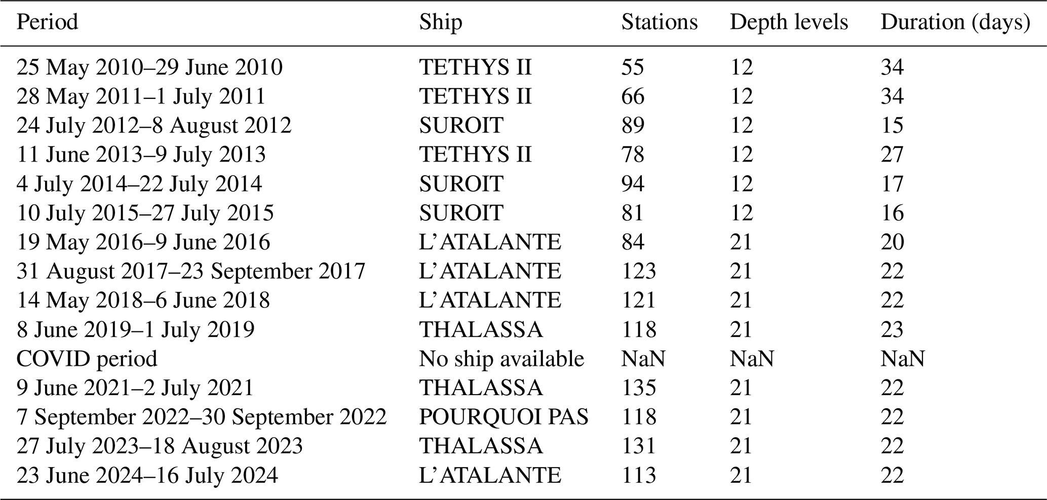
This large-scale network of stations aims to map the Northwestern Mediterranean Sea over an area of 300 000 km2 between the French southern coast, Menorca and Sardinia/Corsica. From 2010 to 2024, 60 to 130 stations were sampled each year for two weeks to one month between May and September, depending on the size of the research vessel allocated by the French Oceanographic Fleet Research Infrastructure (French Ministry of Research and Education, Table 1). This network makes it possible each year to sample the entire Northern Gyre in order to monitor water mass properties (physical and biogeochemical) and their impact on the distribution of plankton species. It also provides an annual reference state for the same EOVs acquired by autonomous platforms (Argo floats, gliders) and the monthly monitoring stations at three sites: DYFAMED, ANTARES, MOLA (Fig. 1).
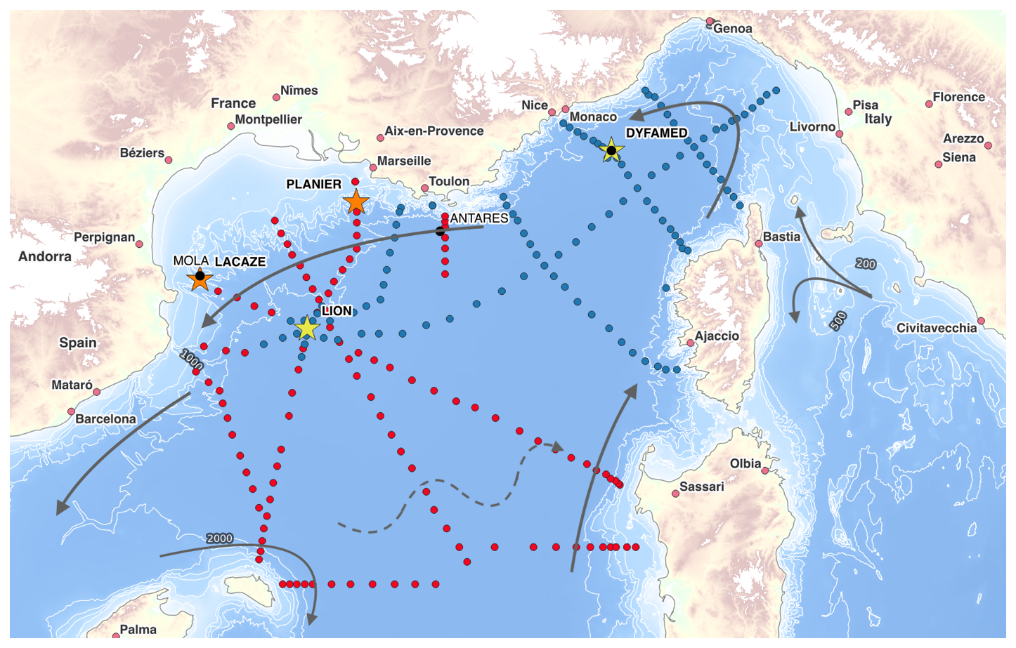
Figure 1Map of the MOOSE-GE cruises showing LEG1 (blue dots) and LEG2 (red dots) stations. EMSO moorings (DYFAMED, LION) are shown as yellow stars, canyon moorings (Lacaze, Planier) as orange stars, and sites with monthly visits as black dots (Mola, Antares, Dyfamed). The LIW circulation is represented by the arrows and the north Balearic Front by the dashed line.
Table 1MOOSE-GE cruise ship, dates, duration and station numbers and depth levels performed each year from 2010 to 2024 (from the first to the last station, excluding the mobilisation/demobilisation days).
The data collected during this cruise directly support the development of Good Environmental Status (GES) indicators, in particular for Descriptor D1 (Biodiversity, Pelagic habitats including marine mammals, turtles and seabirds) and Descriptor D5 (Eutrophication) and Descriptor D10 (Marine litter) of the Marine Strategy Framework Directive (MSFD). The spatial coverage, resources deployed onboard, and hosting capacities of the research vessels used during the MOOSE-GE cruise enabled the implementation of the MEGASCOPE monitoring protocol. Data are also essential for the development and validation of numerical models (e.g., SYMPHONIE; Marsaleix et al., 2008) as well as long-term climate models (Ruti et al., 2016) in the Mediterranean.
These repeated cruises allow the critical yearly maintenance of two moorings from EMSO European Research Infrastructure Consortium (EMSO ERIC) (EMSO-LION and EMSO-DYFAMED), as well as two coastal moorings integrated in MOOSE (PLANIER and LACAZE-DUTHIERS). Maintaining these systems requires substantial operations (1–3 d of ship time per mooring) conducted in close collaboration among the laboratories involved in the MOOSE network and EMSO-France (e.g., inter-calibration of mooring sensors with reference shipborne measurements). Transits between mooring sites are used to perform hydrological sections across the study area (Gulf of Lion, Balearic Islands, Ligurian Sea, Corsica/Sardinia). These hydrographic stations serve two purposes: (1) calibrating moorings and autonomous platforms sensors deployed under MOOSE and EMSO-France, and (2) providing a large-scale “snapshot” of the study region with additional analysis performed from water samples and plankton nets (nutrients, dissolved inorganic carbon, phytoplankton pigments, zooplankton nets). The quasi-synoptic completion of this network (in less than one month) provides an annual large-scale mapping of the distribution of water masses and their hydrological, chemical, and biological properties.
In more detail, the MOOSE-GE cruises consist of four main activities (divided in two legs of 11 and 12 d):
-
Hydrographic stations (Conductivity, Temperature, Depth (CTD) with Niskin bottles): a CTD probe equipped with temperature, salinity, dissolved oxygen, fluorescence, currentmeters (lowered-ADCP), and an Underwater Vision Profiler (UVP) with 21 Niskin bottles are deployed to profile from surface to bottom. Since 2017, 120–130 stations have been sampled each year, according to three categories:
-
Classical stations: water samples for nutrients and chlorophyll-a only.
-
Reference stations: one per day, including “classical” variables plus dissolved oxygen, salinity, pigments, and carbonate chemistry on two meridional reference transects.
-
Biological stations: collection of zooplankton organisms (nets and Niskins). Around 15 stations include zooplankton tows (three hauls each: two from 0–200 m and one from 0–500 m).
-
-
Mooring maintenance of LACAZE-DUTHIERS and PLANIER, as well as EMSO-France moorings DYFAMED and LION.
-
Deployment and recovery of autonomous platforms (Argo profiling floats and underwater gliders). Since 2012, more than 42 Argo floats have been deployed in the western Mediterranean basin, with profiles from 0–2000 m every 5 d and a parking depth of 1000 m. These floats complement the annual MOOSE-GE spatial snapshots by providing continuous basin-scale temporal coverage between cruises.
-
Student training, involving MSc students (Sorbonne University, Ecole Polytechnique, ENSTA) as well as many interns and PhD students from the Oceanography program in Paris (Sorbonne University, École Polytechnique) in hands-on oceanographic fieldwork involving multidisciplinary experts of the region.
With an average of 20–30 km spacing between stations, the MOOSE-GE network (Fig. 1) does not resolve properly mesoscale eddies in the region characterized by a small deformation radius of about 10 km (Beuvier et al., 2012; Escudier et al., 2016), but it has still been able to opportunistically sample properties of small-scale deep water eddies due to an extensive spatial coverage (Bosse et al., 2016, 2017). The distance between stations is however reduced near the continental slope in order to resolve the permanent frontal circulation of the Northern Current and the Western Corsica Current. At the basin scale (∼ 400 km), this resolution provides thorough information on the properties of key water masses (AW, LIW/WIW, WMDW), with about 15 stations per cross-basin transect. The network was designed to capture the large-scale flow centered on the deep convection zone off the Gulf of Lion (Testor et al., 2018), and allows the monitoring of the dense water cascading from the shelf (Durrieu de Madron et al., 2013). Stations located on the continental slope are more closely spaced (depending on bathymetry), allowing fine resolution of steep frontal gradients, which are stronger there than offshore or nearshore. The annual MOOSE-GE monitoring cruise thus provides a unique basin-scale spatial coverage along the main circulation pathways, which can be used to describe interannual variability of water mass properties (T, S, O2) in relation to the dynamics of the Northern Gyre, i.e., the system formed by the Northern Current and its recirculations (Northern Balearic Current and Western Corsica Current).
Because MOOSE-GE cruises follow the requirements of the SNO framework (National Observation Service from CNRS-INSU), they ensure rapid dissemination of station data (from physics to biology) through CORIOLIS Global Data Assembly Center (real-time) and SISMER, the French Research Vessel's database (delayed mode). Over the years, they have become a recognized example of a repeated European-scale cruise, serving as a demonstrator for national and European observing initiatives.
To reduce the environmental footprint of the ship, transit speed has been reduced to 8 kn since 2024, lowering fuel consumption without significantly affecting the station network. The sampling strategy is also being adapted to new techniques in light of results obtained since 2017.
The impacts of climate change and anthropogenic pressures in the Mediterranean are expected to cause major shifts in biodiversity, as well as in the structure and functioning of marine ecosystems, which could ultimately degrade resource quality and disrupt human uses such as fisheries. One objective of the MOOSE-GE cruises is to establish a systematic monitoring of plankton communities from end to end (from viruses to zooplankton), including prokaryotes, phytoplankton, micro- and mesozooplankton, in relation to environmental variables. This approach aims to provide a comprehensive overview of biodiversity trends and, ultimately, their consequences on the biogeochemical and trophic functioning of the pelagic ecosystem. To this end, we rely on imaging methods for zooplankton analyses, complemented by environmental genomics for the microbial and mesozooplankton compartments (during annual cruises only), using simple and standardized sampling procedures. This combination allows monitoring of the evolution of plankton communities as a whole, and the detection of non-indigenous species in relation to climate warming (Lescot et al., 2026).
Since 2014, biodiversity monitoring had been based on 15 biological stations scattered across the basin, covering various marine ecosystems (coastal vs. offshore, oligotrophic vs. mesotrophic). After ten years, this strategy failed to detect interannual trends, mainly due to (i) the varying seasonal timing of MOOSE-GE cruises, and (ii) the dispersed geographical coverage, which prevented linking observations to specific hydrographic structures. The recent analysis of the 2017–2019 cruises (spanning May to September) highlighted the challenge of interpreting biological data collected via imaging and genomics at variable periods (Lescot et al., 2026). From 2024/2025 onwards, biodiversity monitoring therefore focuses on the two major north–south transects: Nice–Calvi (10 stations) and Marseille–Minorca (15 stations). This revised strategy not only doubles the number of biological stations (25 in total), but also enables repeated sampling along well-characterized hydrographic gradients and day–night (nycthemeral) monitoring of planktonic communities across water masses with contrasting properties (e.g., temperature, salinity, nutrients). Data exploitation will thus be possible: (1) at the interannual scale when cruise periods are consistent across years; (2) through process studies along the two transects when periods differ; or (3) following anomalous events such as intense marine heatwaves. The plankton net sampling strategy has also been revised, using bongo nets to 200 m depth with 20 and 200 µm meshes, combining imaging (zooplankton) and genomic analyses (microbial and mesozooplankton diversity).
Until 2024, MOOSE-GE cruises had mainly focused on the offshore domain, and observations at interfaces lacked more spatially resolved and repeated monitoring of the Gulf of Lion's shelf. Extension of the cruise network to the Gulf of Lion shelf with 12 coastal stations following the 50 m isobath has been adopted since 2024 for monitoring the Rhône river inputs and their impacts on the biogeochemical properties of the water column (without increasing ship time, but by optimizing the number of stations). This transect makes it possible to compare offshore signals driven by global changes with coastal signals influenced by direct anthropogenic forcing. It also provides essential biogeochemical measurements on the shelf, particularly to monitor the impact of Rhône inputs on carbonate chemistry (e.g., pH, alkalinity) and to validate specific regional numerical model (e.g., SYMPHONIE ECO3M-S). High-frequency monitoring of riverine inputs remains a central objective of the national coastal network such as COAST-HF and SOMLIT (ILICO-RI), and it is therefore crucial to integrate this land-sea continuum observation within the MOOSE network using the same strategy applied to offshore stations.
The MOOSE program (CNRS-INSU) has initially focused on ensuring the sustained acquisition of EOVs required to meet the objectives of the different scientific challenges, while also providing the basis for marine environmental descriptors, particularly those related to eutrophication and biodiversity. To achieve this, MOOSE has relied on community-endorsed techniques and procedures, with particular attention to: (1) ensuring their homogeneous application across all sites and partners, (2) promoting shared analytical efforts, and (3) preparing common protocols for sampling and analyses. MOOSE also relies on National Analytical Services (CNRS-INSU) that apply strict quality control procedures (e.g., SAPIGH for pigments – Dimier et al., 2024; SNAPCO2 for carbonate system parameters – Metzl et al., 2024). Data validation within MOOSE is carried out first by the scientists responsible for sites and/or platforms, who comply with internationally recognized analytical protocols (standards, intercalibration exercises, comparison with long-term climate series), and subsequently by the national data centers (SISMER, CORIOLIS), which perform systematic checks before archiving (identification of outliers, doubtful values, etc.). This process allows each dataset to be assigned a quality code: SeaDataNet quality flags (QF) for CTD and bottle data archiving (SISMER), OceanSITES QF for mooring time series (CORIOLIS) and Argo/OceanSITES scale for gliders with some specific real-time and delayed mode quality codes (Hebden and Buck, 2019).
3.1 CTD rosette
The number of CTD casts ranged from 57 to 137 (Table 1) from which seawater samples have been collected for different physical, chemical and biological variables analysis (Table 2). All CTD profiles were performed from surface to near bottom using an altimeter (5–10 m above the seafloor) and Niskin bottles collected samples at standard depths from surface (5 m) to the deepest depth (max 2850 m). Once per day, water samples at three levels (surface, salinity maximum of intermediate waters near 350 m, bottom) were taken for salinity analysis. The samples were then analyzed on board using a Guildline Autosal Salinometer. An offset from OSIL standard water varied from −0.005 to 0.005 depending on the laboratory temperature.
Table 2Data acquired during the MOOSE-GE cruises with frequency and methodology, with each variable linked to the corresponding GOOS Essential Ocean Variable (EOV) and, where relevant, GEO BON Essential Biodiversity Variable (EBV) class.
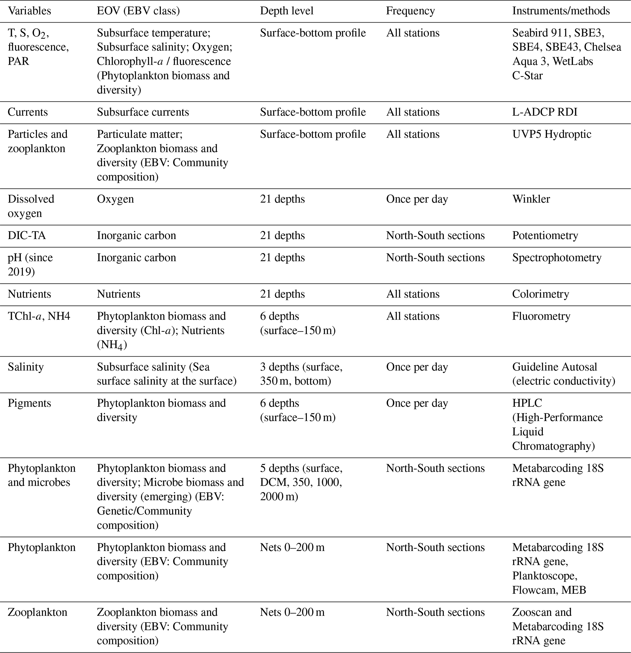
CTD system used for all MOOSE-GE cruises was a Seabird SBE9plus + CTD from Villefranche marine station connected to a SBE11 deck unit, configured with a 12-position SBE32 Carousel Water Sampler (from Villefranche or Marseille laboratory) from 2010 to 2015 and a 24-position SBE32 Carousel Water Sampler (from DT-INSU, Brest) since 2016 with 12 L Niskin bottles (all years). The position of three Niskin bottles was occupied by the L-ADCP system and the UVP5 (sn002) was mounted outside for the 12-bottle rosette and inside for the 24-bottle rosette. The CTD system was equipped with two sensors for temperature and conductivity (SBE3 and SBE4) in order to improve the final data quality, one oxygen sensor (SBE43) with a second since 2016 (JFE RINKO III), a fluorometer (Chelsea), and an altimeter. For each cruise, sensors had been recently calibrated by the manufacturer (Seabird) and rotated every year, while the general system configuration remained exactly the same, except on occasions where sensor damage required temporary substitution
Temperature, salinity, oxygen and pressure data were post-processed using Seabird's processing routines following GO-SHIP's recommendations described in McTaggart et al. (2010) and in Uchida et al. (2010). MATLAB and more recently PYTHON routines were used for the final quality assessment and control of Temperature, Salinity and Oxygen data. Spikes were removed and adjusted 1 dbar bin-average profiles were archived on SISMER data server (Coppola et al., 2010). To adjust the conductivity and oxygen sensors installed on the CTD rosette, salinity and oxygen data were compared with reference bottles samples analyzed with the salinometer and Winkler method, respectively. The different adjustments minimizing residuals (slope coefficient on conductivity for SBE4; an iterative optimization adjusting three coefficients – SOC, VoffSet, E – for SBE43) were carefully performed during the CTD profiles post-processing. This standard procedure ensures an overall accuracy within the expected range for temperature (0.001° C), salinity (0.002 g kg−1) and oxygen (±2 µmol kg−1).
3.2 L-ADCP and S-ADCP measurements
The shipboard Acoustic Doppler Current Profilers (S-ADCP) used during MOOSE-GE cruises depends on the year and the ship (RDI's OS 150 kHz (range 21–300 m, dz =8 m) for 2012, 2014, 2015 on RV Suroit, and 2013 on RV Tethys; OS 150 and OS 38 kHz (range 21–1200 m, dz =24 m) since 2016 on RV Thalassa, L'Atalante or Pourquoi Pas? (Bosse et al., 2024a). The S-ADCP data averaged over a 2 min period were concatenated and processed using Cascade V7.2 processing software (Kermabon et al., 2023) to compute horizontal ocean current velocities with a spatial resolution of 2 km, corrected for navigation and ship attitude parameters, and filtered according to various quality criteria (i.e., thresholds on vertical velocity error, vertical shear, correlation, minimum percentage of valid ensembles, Kermabon et al., 2023). Bathymetry (Etopo 1 with 1 arcmin resolution) was incorporated in the processing to account for bottom detection. The profile data for the meridional and zonal components of the current for the two S-ADCPs were combined to obtain a complete profile between 21 and 1200 m depth with maximum resolution in the surface layer.
In addition to the S-ADCP measurements, current data have also been collected between the surface and the bottom using a dual-head lowered acoustic Doppler current profiler (L-ADCP) system since 2012. Two 300 kHz RDI Workhorse ADCP current meter attached to the CTD-rosette were deployed in master/slave mode, one looking up and one down. Data have been processed using the LDEO software (A.M. Thurnherr, “How to process LADCP data with the LDEO Software (Versions IX.7-IX.10)” , Internal report march 2014). External qualified data (CTD, S-ADCP, GPS) are used to process L-ADCP data. S-ADCP data with a temporal resolution of two minutes for station profiles were used to constraint the L-lowered ADCP data from the upper part of the water column (between the surface and 1200 m deep).
3.3 Underwater Vision Profiler (UVP)
The Underwater Vision Profiler (UVP) was designed to measure the vertical distribution of macroscopic particles larger than 100 µm and zooplankton larger than 1 mm (Picheral et al., 2010). Its lower detection limit is set by optical resolution, while the upper limit depends on the volume of water illuminated in each frame. The fifth-generation UVP (UVP5) is a compact instrument (30 kg in air) that has been deployed as a stand-alone system with an independent power supply on CTD-rosette package during the MOOSE-GE cruises (Kiko et al., 2022). It records images at up to 6 Hz during the downcast of a CTD profile. The UVP5 therefore takes 5–25 pictures of the water column, depending on the depth layers considered (1–5 m). Image acquisition and analysis occur in real time with direct return on-board when interfaced with a CTD. The particles in each image are counted and sized immediately, and the data are stored in the instrument. Data were analyzed with the zooprocess software directly on-board with a first quality control to only select timing corresponding to the profile. Data were afterward transferred to EcoPart (https://ecopart.obs-vlfr.fr/, last access: 17 July 2026) for final calculation of particle abundance and biovolume, while images were uploaded to EcoTaxa (Picheral et al., 2025; Irisson et al., 2022).
3.4 Dissolved oxygen
Dissolved oxygen measurements were obtained with a Seabird SBE43 sensor, calibrated against Winkler titrations carried out on board. Water samples were collected once per day from CTD-rosette casts equipped with Niskin bottles, spanning the water column from the surface to just above the seafloor. Winkler measurements were performed using potentiometric detection of the equivalence point with a Metrohm 888 Titrando titrator between 2010 and 2018. Since 2019, a new system called “EndPoint” based a monochromatic wavelength spectrophotometer to drive the titration dynamics and determine the final endpoint (Williams et al., 1982) was used, thereby increasing the reproducibility of the measurements. The accuracy of the measurement was controlled with a KIO3 standard solution, prepared with dried potassium iodate dissolved in ultrapure water. The exact concentration of the homemade KIO3 standard was determined by titrating it against a potassium iodate standard solution of 0.0100 N (WAKO). SBE43 sensor calibration coefficients were refined for the entire cruise using the least-squares adjustment method described in Coppola et al. (2018) and used in the CTD data post-processing method.
3.5 Nutrients, chlorophyll-a and ammonium
Samples for dissolved inorganic nutrients were collected from Niskin bottles in 20 mL polyethylene (HPDE) bottles and filled with 100 µL of HgCl2 solution (6 g L−1) and stored onboard before being analyzed in the laboratory. They were analyzed by a standard colorimetric method on a segmented flow analyzer (autoanalyzer Seal AA3 HR) following Aminot and Kérouel (2007). The limits of quantification are 0.03 µM for nitrite, 0.05 µM for nitrate, 0.03 µM for phosphate and 0.05 µM for silicate with a precision of 3 %. Nutrient standardisation and data quality were assured through successful and continuous participation in international intercalibration exercises. During the cruise, measurements were further verified with the use of OSIL (OceanScientific International Ltd) marine nutrient standards (ISO9001 accredited).
Chlorophyll-a concentrations were determined from discrete water samples collected in the water column. Pigments were extracted in methanol and quantified onboard by fluorimetry following the protocol described by Raimbault et al. (2004). The limit of quantification for chlorophyll a was 0.05 µg L−1, and the analytical precision was estimated at 15 %.
Ammonium concentrations were measured on board by fluorimetry following the method of Holmes et al. (1999). The limit of quantification (LQ) was 0.02 µM, and the analytical precision was estimated at 3 %.
3.6 Discrete CO2 measurements (DIC, TA, pH)
Samples for DIC and TA were collected into acid-washed 500 cm3 borosilicate glass bottles and poisoned with 200 mm3 of a half saturated HgCl2 solution (final concentration of ca. 20 mg L−1), following the recommendation of Dickson et al. (2007). Samples were stored in the dark at 4° C pending analysis. Measurements of DIC and TA were performed simultaneously on the same sample by potentiometric acid titration using a closed-cell following the methods described by Edmond (1970) and Dickson and Goyet (1994). Analyses were performed at the National facility for the analysis of carbonate system parameters (SNAPO-CO2, Metzl et al., 2024) between 3 months and one year after the end of the cruise. The average accuracy of AT and CT analysis (estimated from repeated measurements of Certified Reference Material provided by Prof. Dickson's laboratory from the Scripps Institution of Oceanography, San Diego) was between 2 and 4 µmol kg−1 for the different MOOSE-GE cruises.
Since 2019, pHT (total pH) measurements were performed directly on board. Samples for pH measurements were collected in cylindrical optical glass vials and analyses were performed manually using purified m-Cresol Purple (mCP – provided by Prof. Byrne, University of Southern Florida) following the spectrophotometric protocol (at 25° C) described by Clayton and Byrne (1993). pH is reported on the total scale at the temperature of measurement in the lab (close to 25° C) using the equation by Liu et al. (2011). The reproducibility of measurements was estimated to be ± 0.001 by measuring replicates from the same Niskin bottle. The accuracy was determined to range within ± 0.005 by analysing replicates of TRIS solution (provided by Prof. Dickson, Scripps Institution of Oceanography, San Diego or by the Laboratoire National de Métrologie – LNE, Paris).
3.7 Dissolved Organic Carbon (DOC)
Since 2016, DOC sampling has been performed during the annual MOOSE-GE cruises along the two north–south transects, Nice–Calvi and Marseille–Minorca (about 350 samples per year and 700 duplicate analyses). Samples are collected into precombusted glass tubes and acidified with orthophosphoric acid (H3PO4) and analyzed in the laboratory by high temperature catalytic oxidation (HTCO) on a Shimadzu TOCV analyzer. Typical analytical precision is ± 0.1–0.5 (SD) or 0.2 %–1 % (CV).
3.8 Phytoplankton pigments
Phytoplankton pigments have been collected once per day since the start of the MOOSE cruises. The seawater was collected by Niskin from surface (5 m) to 150 m and filtered through GF/F filters (Φ25 mm, 0.7 µm poresize, Whatmann, Germany) for HPLC (High Performance Liquid Chromatography) measurements, were preconditioned under constant mild vacuum (not exceeding 0.5 bar), flash freeze in liquid nitrogen and successively stored at −80° C. The filtration volumes varied from 1000 to 3520 mL. The samples have been analysed by a CNRS-INSU national service (SAPIGH) based in Villefranche/Mer laboratory. The service uses HPLC method to measure chlorophylls and carotenoids in the marine environment (Dimier et al., 2024). It enables the separation and quantification of >25 different pigments that provide information on the biomass, composition and photo-physiological status of phytoplankton communities.
3.9 Biodiversity data
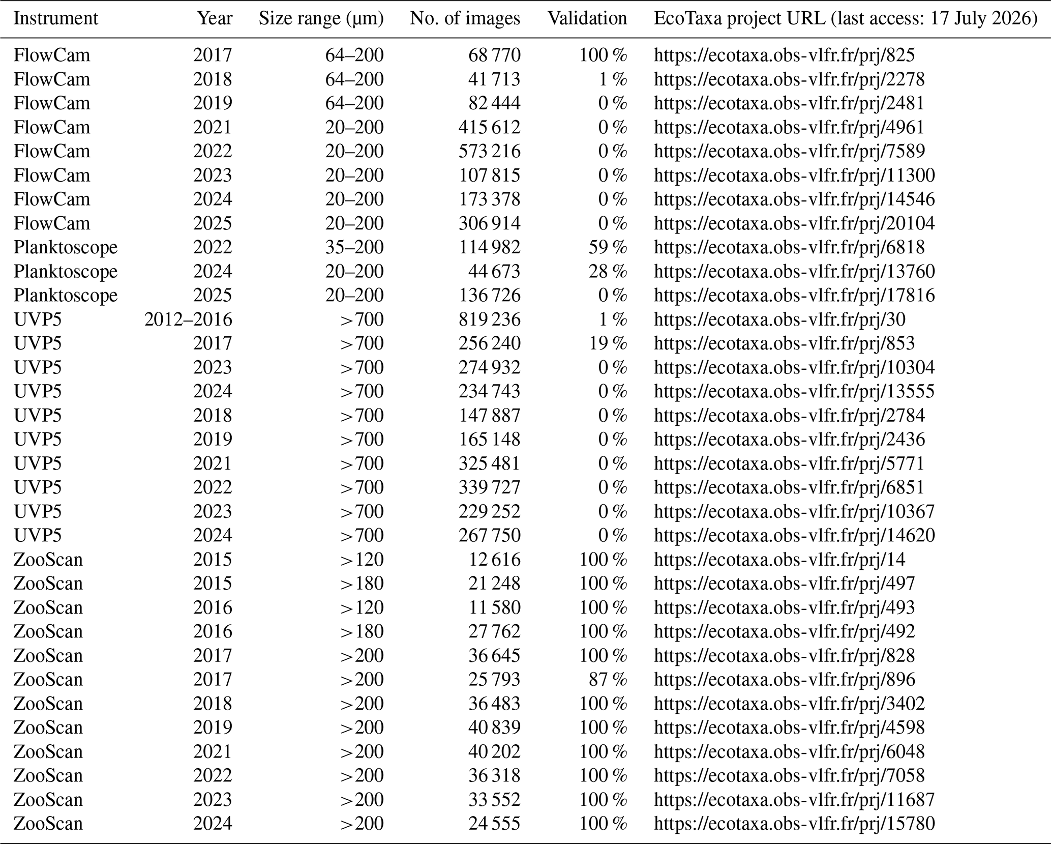
Biological variables are monitored using quantitative imaging instruments on samples collected from multiple net tows (20, 64, 200, and 500 µm mesh), following procedures established by the Quantitative Imaging Platform of Villefranche-sur-Mer (an EMBRC-labeled platform). Zooplankton samples are collected using vertical net hauls (200 µm mesh, 0–200 m) following international standard protocols (Harris et al., 2000). Samples from the nets are preserved with either formalin (4 % final concentration, buffered with borax) or acidic Lugol solution (for the 20 µm net tows) and analyzed on land using multiple imaging devices (UVP, Zooscan, FlowCam, and Planktoscope; see Table 4); only Planktoscope samples (20 µm net) are imaged live on board. Identical protocols are applied across monthly stations and MOOSE-GE cruises (Fig. 8), following Perruchon et al. (2025) for the Planktoscope, Jalabert et al. (2025a) for the Zooscan, and Jalabert et al. (2025b) for the FlowCam; descriptions of final image data and associated metadata for all instruments are provided in Picheral and Mériguet (2025). Since 2014, this imaging approach has been applied consistently across MOOSE, providing both quantitative data (abundance, size, biovolume) and qualitative data (taxonomic groups, dry weight) that can be readily linked with physical, chemical, and biological databases.
The integration of environmental genomics as a complementary activity of the MOOSE network was initiated in 2017 by the Roscoff, Marseille, and Villefranche laboratories (Lescot et al., 2026), building on long-term time series experience in the Mediterranean Sea, genomic observatories at marine stations, and the Tara expeditions, and following international standards in the field (Santi et al., 2021). This approach aims to: (1) describe the biological diversity of plankton assemblages in an oceanographic context; (2) implement a simple, standardized sampling procedure integrated into long-term monitoring; and (3) rapidly disseminate meaningful data to the community. Samples are collected using plankton nets and Niskin bottles. Net samples are used to describe the molecular diversity of phyto- and zooplankton components (>20 µm, >200 µm) and to quantify mesozooplankton through in situ automated imaging (UVP). Niskin bottle samples allow microbial diversity to be studied along the water column through (1) metabarcoding analyses of plankton assemblages in two size fractions (0.2–3 µm for bacteria/picoeukaryotes, and 3–200 µm for phyto/small zooplankton), and (2) metagenomic analyses to assess prokaryotic functions. During each MOOSE-GE cruise, approximately 400 samples are collected for genomic analyses.
For eDNA sampling, plankton net samples are filtered through 10 µm pore-size filters and frozen in liquid nitrogen. Seawater collected with Niskin bottles at three depths (surface, chlorophyll maximum, and deep >2000 m) is pre-filtered at 200 µm and then sequentially filtered onto 3 and 0.2 µm filters to target planktonic size fractions for metabarcoding and metagenomics; filters are stored in liquid nitrogen until analysis. DNA extraction and library preparation follow protocols established in international initiatives (e.g., Tara Oceans, EMO-BON), detailed on protocols.io (https://doi.org/10.17504/protocols.io.kxygxy5xdl8j/v1 for extraction; https://doi.org/10.17504/protocols.io.bzucp6sw for amplification and library construction). Approximately 1 µg of pooled amplicons is sequenced by high-throughput paired-end sequencing (2×250 bp, MiSeq Illumina) at Fasteris-GeneSupport (Plan-les-Ouates, Switzerland).
3.10 Deep moorings and sediment traps
The PLANIER and LACAZE-DUTHIERS moorings, at the eastern and western ends of the Gulf of Lion, are equipped with PPS3 sediment trap (Technicap) and Aquadopp current meters at 500 and 1000 m deep. The LION and DYFAMED moorings are equipped with SBE37 (CT sensors), SBE37-ODO (oxygen sensors), SBE56 (temperature sensors), and Aquadopp current meters, deployed from 100 m below the surface down to 2300 m. In addition, LION includes a PPS3 sediment trap at 2300 m, which is designed to collect particles originating from the settling of surface material, the resuspension of local sediment and lateral inputs from the Gulf of Lion shelf and canyons (Stabholz et al., 2013; Durrieu de Madron et al., 2017). DYFAMED, on the other hand, is equipped with two PPS5 sediment traps at 200 and 1000 m, which collect marine snow as well as biogenic and lithogenic particles derived from biomass blooms and atmospheric inputs (Miquel et al., 2011; Heimbürger et al., 2013). The design of the different moorings is shown in Fig. 2.
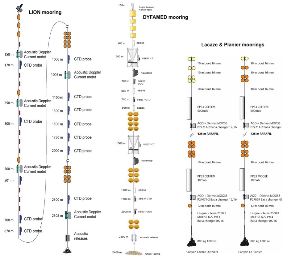
Figure 2Moorings design of LION, DYFAMED, Lacaze and Planier deployed in the northwestern Mediterranean Sea region.
The CTD profiles and discrete bottle samples collected during the cruises provide the primary calibration and quality-control reference for the mooring-based observations. Moorings are serviced annually to recover one-year datasets and sediment-trap samples (preserved in 5 % formaldehyde), to limit biofouling, and to ensure metrological consistency across successive deployments. During each servicing, mooring sensors are cross-calibrated against the shipborne CTD-rosette (with recently calibrated sensors) using dedicated comparison casts performed at 2–3 target depths (typically near-surface, 300–400 m, and ∼ 1000 m). Sensors are held at each level for ∼ 30 min, enabling the detection and correction of deployment-related sensor drift and offsets, as well as inter-sensor consistency checks along the mooring line. After recovery, moored time series undergo delayed-mode processing including pressure-dependent corrections, despiking, temporal coherence checks, and the identification/removal of biofouling-related artefacts, with particular attention to low-frequency drifts affecting conductivity and dissolved oxygen measurements. After adjustment of T, S, and O2 data, these observations allow the detection of basin-scale variability with high accuracy (0.001 ° C, 0.005 g kg−1, Houpert et al., 2016; ±2 µmol kg−1, Coppola et al., 2018). This measurement protocol has been documented in a best practice report for Eulerian measurements described by Coppola et al. (2016) and published by Pearlman et al. (2019).
The processing of Aquadopp current meter records involves several steps to produce clean, validated hourly time series for pressure, temperature, and horizontal current speed and direction. First, the raw data are offloaded from the instrument and converted to scientific units using manufacturer calibration routines. Quality control procedures such as spike removal, gross error filters, and flagging of suspect records are applied to exclude outliers and faulty measurements. For vertical speed, the instrument's movements on the mooring line, identified from pressure records, are subtracted from the measured vertical velocity to correct for mooring motion.
3.11 Sensors calibration and data correction
Sensor calibration and correction procedures are fundamental to the MOOSE observing system, as they underpin climate studies based on long-term monitoring and provide a robust reference for ocean model evaluation. In particular, the ability to detect and quantify subtle changes in water mass properties is essential for documenting climate-driven trends, especially in deep and intermediate waters where long-term variations in temperature, salinity and dissolved oxygen are small but climatically significant (Somot et al., 2018; Coppola et al., 2018). Within MOOSE, rigorous calibration and data correction procedures are therefore implemented to ensure the long-term consistency and traceability of physical and biogeochemical observations acquired by CTD-rosette systems and autonomous mooring sensors. All CTD measurements collected during the monthly cruises and the annual MOOSE-GE campaigns rely on shipborne rosette systems equipped with high-accuracy temperature, conductivity and pressure sensors, operated following international best practices (GOOS/OBPS) and calibrated every year by the manufacturers. Pre- and post-cruise laboratory calibrations are complemented at sea by systematic comparisons with discrete water samples: salinity is calibrated against IAPSO Standard Seawater using Guildline Autosal analyses, while dissolved oxygen sensors are calibrated using Winkler titrations. These reference measurements are used to derive sensor-specific correction coefficients, which are applied uniformly to the full CTD profiles. During the annual MOOSE-GE campaigns, dedicated CTD stations are additionally performed in the immediate vicinity of deep moorings (e.g. DYFAMED, LION, Planier and Lacaze-Duthiers canyons) to cross-calibrate autonomous sensors (see Sect. 3.10). All corrections are documented and applied in delayed-mode processing, ensuring internal consistency between Eulerian (moorings, ship stations) and Lagrangian platforms (gliders, Argo floats), for which the ship-based CTD observations serve as regional calibration references. The resulting quality-controlled datasets constitute the backbone of the MOOSE long-term time series and provide a robust and traceable basis for detecting climate signals, evaluating numerical models and quantifying long-term changes in Mediterranean water mass properties.
Although the concept of the MOOSE program is based on an integrated vision of all available data in the NW Mediterranean basin, the MOOSE- GE cruises have highlighted some major results:
-
Increase in the heat and salt content of the LIW (data obtained from the EMSO-LION and EMSO-DYFAMED moorings, later validated and corrected with cruise data) and propagation of LIW changes throughout the basin (Margirier et al., 2020).
-
Detailed monitoring of the vertical structure of the deep waters (not captured by Argo floats profiling at 2000 dbar maximum) which documented at the scale of the oceanic basin the intense event of dense waters cascading from the Gulf of Lion's shelf in 2012 (Durrieu de Madron et al., 2013), the impact of shelf and open-ocean convection on particles distribution (Durrieu de Madron et al., 2017), the subsurface mesoscale eddy field (Bosse et al., 2016) and its coupling with biogeochemistry (Bosse et al., 2017), as well as the recent warming of deep waters and vertical structure during years of reduced deep convection intensity (Bosse et al., 2024b).
-
Development of a prediction algorithm for carbonate and nutrient variables based on using predictions from a neural network (CANYON-MED), trained with cruise data from 1986 to 2018, including MOOSE-GE (Fourrier et al., 2020, 2022).
-
Detection of trends in nutrients with an increase in deep waters (Belgacem et al., 2021; Fourrier et al., 2022).
-
Detection of an increase in inorganic carbon and a decrease in pH in surface, intermediate and deep waters in the Ligurian sea based on MOOSE-GE data and other MOOSE time series (Coppola et al., 2020; Metzl et al., 2024).
-
Three distinct zooplankton groups were identified in 2017 based on integrated 0–200 m values of environmental variables: the first with stations mainly located in the Ligurian Sea, and the other two in the northern and southern parts of the Provençal basin, highlighting a marked north-south gradient (PhD thesis of Feliu, 2020)
-
The increased frequency of the MOOSE-GE cruises in collaboration with the MISTRALS programme (Mediterranean integrated studies at regional and local scales) during the year 2012-2013 allowed to assess the seasonal cycle of the NW Mediterranean deep water mass characteristics from August 2012 to June 2013 and, for the first time to our knowledge, to estimate with only in-situ observations the WMDW Formation rate of that record-breaking convective year (Waldman et al., 2016; Testor et al., 2018).
4.1 Physical variables
The deep water temperature in the NW Mediterranean Sea has been increasing by about 0.3° C since the 1950s (Béthoux et al., 1990; Krahmann and Schott, 1998), and projections to 2100 predict a strong rise in surface temperatures (Darmaraki et al., 2019; Soto-Navarro et al., 2020), which could notably disrupt the reproductive cycles of many marine species (Lejeusne et al., 2010). This evolution is closely linked to winter convection induced by cold, dry winds (Mistral and Tramontane) channelled by the surrounding mountain ranges over the Gulf of Lion (Estournel et al., 2016), in a zone preconditioned by cyclonic ocean circulation. Convection ventilates intermediate and deep waters and drives the spring bloom, the largest in the Mediterranean, typically observed in April as the water column restratifies (Herrmann et al., 2017).
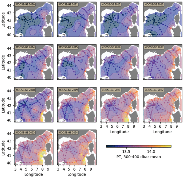
In this context, CTD profiles collected throughout the entire water column during the annual MOOSE-GE cruises provide a valuable long-term record of intermediate waters (Levantine Intermediate Water, LIW) and deep waters (Western Mediterranean Deep Water, WMDW), revealing strong interannual to decadal variability and a rapid increase in temperature and salinity within both water masses (Figs. 2 and 3; Testor et al., 2018; Somot et al., 2018; Margirier et al., 2020). Winters from 2010 to 2013 were distinguished by bottom-reaching convection events (down to 2400–2500 m; Houpert et al., 2016), whereas since 2014 winter mixing has been considerably weaker (300–500 m on average, except in 2015 and 2018 when mixing reached ∼ 1500 m), driven by weaker buoyancy losses and enhanced water-column stratification (Margirier et al., 2020; Josey and Schroeder, 2023). As a consequence of this reduced deep mixing, and of a strong advection of warmer and saltier LIW through the Strait of Sicily (Schroeder et al., 2017), waters between 200 and 600 m have warmed by about 0.5° C within a decade across the whole Northwestern basin. This intermediate-depth warming is progressively transferred to deeper layers: since 2019, waters below 2000 m have warmed continuously at a rate of about 0.002° C yr−1, driven by turbulent mixing conveying heat from the LIW to the deep waters in the absence of deep convection.
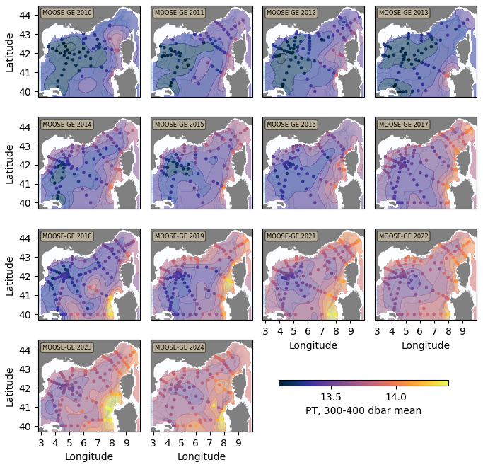
Figure 3Maps of the spatial distribution of potential temperature in the 300–400 dbar layer, representative of the Levantine Intermediate Water (LIW), in the northwestern Mediterranean Sea basin for each MOOSE-GE cruise from 2010 to 2024. The background field corresponds to an optimal interpolation (correlation length scale of 100 km) of the station observations, which are shown as colored dots.
4.2 Biogeochemical variables
The northwestern Mediterranean is a highly dynamic region due to the intense convection and ventilation processes that occur in winter (Conan et al., 2018; Coppola et al., 2017). These processes lead to rapid changes in the content of biogeochemical elements (gases, nutrients), with implications for phytoplankton production. The impact of physical processes on bloom dynamics, through physical–biogeochemical coupling in the mixed layer and the resulting vertical fluxes, remains poorly understood, and integrated observations can provide new insights.
The combined MOOSE-GE cruise data show that dissolved oxygen (DO) in LIW and WMDW is strongly modulated by shifts in convection regimes. During the period of intense deep convection (2010–2013), enhanced ventilation led to higher DO in both water masses, with LIW concentrations reaching about 190 and 210 µmol kg−1 in the WMDW (Fig. 5). In contrast, during the subsequent weak-convection period (2014–2024), reduced vertical mixing limited oxygen renewal in intermediate and deep layers while respiration and organic-matter remineralization continued. The decline is particularly evident in the LIW, where the oxygen minimum layer progressively intensified and expanded vertically in the absence of regular convective events (Coppola et al., 2018), with DO now reaching ∼ 170 µmol kg−1. Deep waters also exhibit a marked decline over this period, with an DO decrease of approximately 1 µmol kg yr−1 and WMDW concentrations now around 190 µmol kg−1 (Fig. 5). Episodic convective winters partially interrupted this decline by temporarily increasing DO, but these effects remained short-lived. Overall, the MOOSE-GE observations indicate that the LIW and WMDW are now significantly less ventilated, with a clear and persistent decline in DO that is particularly pronounced and in particular in the LIW (Fig. 5). This pattern is consistent with a slowdown of deep convection under ongoing Mediterranean warming, which reduces episodic oxygen renewal while oxygen consumption by respiration and remineralization continues. Although oxygen levels remain well above hypoxic thresholds, the emerging LIW deoxygenation signal warrants close monitoring, as it could intensify if regional warming and stratification strengthen further in the coming decades.
The annual and monthly MOOSE cruises have provided valuable insight into the seasonal variability of nutrient concentrations throughout the water column. Winter vertical convection supplies surface layers with nutrients, directly fueling primary production (Mayot et al., 2017). As a result of intense biological uptake, nutrient concentrations in surface waters decrease rapidly during spring and remain low, sometimes close to detection limits, from June to October. Despite strong interannual variability, this seasonal cycle is recurrently observed from year to year. Beyond this seasonal signal, the multi-decadal perspective offered by the MOOSE-GE cruises has enabled recent studies to address the long-term evolution of nutrient concentrations. The nutrient time series indicates a sustained increase in nutrient concentrations in deep waters (below 2000 dbar) since 2010, particularly for nitrate and silicate (from 8.5 to 9.2 µmol L−1 and from 8.5 to 10 µmol L−1, respectively; Fig. 6), with this long-term trend being intermittently weakened during strongly convective years (e.g. 2011 and 2013). These trends are interpreted as the combined result of modified deep-water formation rates, changes in ventilation, and enhanced remineralization processes at depth (Fourrier et al., 2022). Since 2014, and again after 2018, MOOSE-GE observations reveal a rapid increase in nitrate and silicate concentrations in deep waters (Fig. 6). This evolution is likely associated with a slowdown of deep convection events, leading to reduced ventilation and the establishment of more homogeneous deep-water masses. Under these conditions, remineralization products progressively accumulate at depth, resulting in increasing nitrate and silicate inventories. In contrast, phosphate exhibits a weaker and, in some periods, opposite trend, with a slight decrease in deep-water concentrations. This behavior likely reflects a decoupling between nitrogen and phosphorus cycles, driven by differential remineralization rates and changes in water mass composition associated with the formation and spreading of new Western Mediterranean Deep Water, with a possible contribution from preferential phosphorus removal through particle-associated processes (Krom et al., 2004; Pasqueron de Fommervault et al., 2015; Schroeder et al., 2017). The resulting increase in deep-water N : P ratios suggest a progressive strengthening of phosphorus limitation in the north-western Mediterranean Sea and highlights the strong sensitivity of deep biogeochemical reservoirs to changes in ventilation and overturning dynamics.
The MOOSE time-series observatories provide also a unique basis for assessing the evolution of the carbonate system in the north-western Mediterranean Sea across seasonal to decadal time scales. High-quality measurements of total alkalinity (TA) and dissolved inorganic carbon (DIC) collected during monthly cruises and annual MOOSE-GE surveys reveal a pronounced seasonal cycle in surface waters, with winter maxima linked to vertical mixing and summer minima associated with biological carbon uptake (Coppola et al., 2019; Wimart-Rousseau al., 2023). It has to be noticed that, for an unexplained reason, DIC and TA data collected during MOOSE-GE 2017 have an unusually high amount of data that have been considered as doubtful during the quality-control procedures and the carbonate data from this year should be considered with caution. In contrast, TA exhibits comparatively weak seasonal variability, reflecting the dominant control of salinity and the limited influence of biological processes. At longer time scales, MOOSE-GE observations over 2010–2024 indicate that TA increased slowly until 2017 before reaching a relatively constant value in intermediate and deep waters (∼ 2600 and ∼ 2590 µmol kg−1 for LIW and WMDW, respectively; Fig. 7), while salinity increased steadily over the same period (by ∼ 0.35 over 15 years in the LIW; Fig. 4). Although TA often covaries with salinity in open-ocean settings, TA trends in the Mediterranean Sea cannot be inferred from salinity changes alone, as increases are also observed in salinity-normalized alkalinity (Metzl et al., 2024). For DIC, the same trend has been observed: an increase of concentrations from 2010 to 2017 (up to 2355 and 2335 µmol kg−1 for LIW and WMDW, respectively) and an apparent stabilization to constant values from 2018 to 2024 for both water masses (Fig. 7). These trends are consistent with those reported by Wimart-Rousseau et al. (2023) and are further supported by the multi-platform analysis and machine learning predictions of Fourrier et al. (2022), which demonstrates that DIC accumulation and pH decline (observed at DYFAMED from Yao et al., 2016; Merlivat et al., 2018; Coppola et al., 2020; Wimart-Rousseau et al., 2023) are strongly modulated by intermittent deep convection. Periods of intense mixing temporarily slow down acidification by ventilating intermediate and deep layers and by injecting waters with higher pH into depth, whereas prolonged stratified periods favor the accumulation of remineralized carbon and accelerate acidification in the absence of renewal. The observed increase in DIC, combined with largely stable TA, reflects the uptake of anthropogenic CO2 and the redistribution of carbon through both physical and biological pumps, with intermediate waters playing a key role in carbon sequestration.
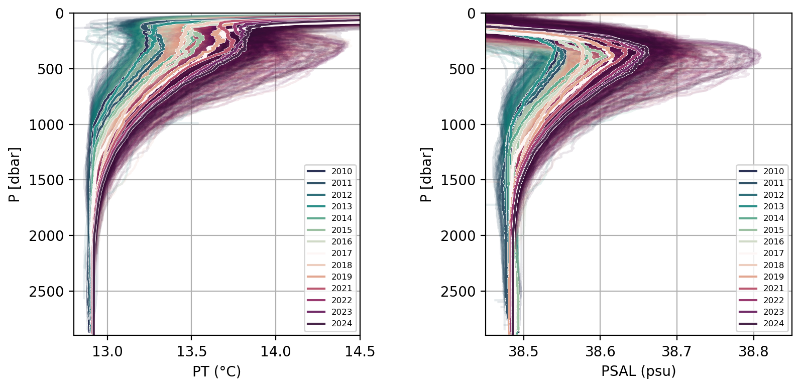
Figure 4Potential temperature and practical salinity vertical profiles during the MOOSE-GE cruises from 2010 to 2024. The color represents the different years.
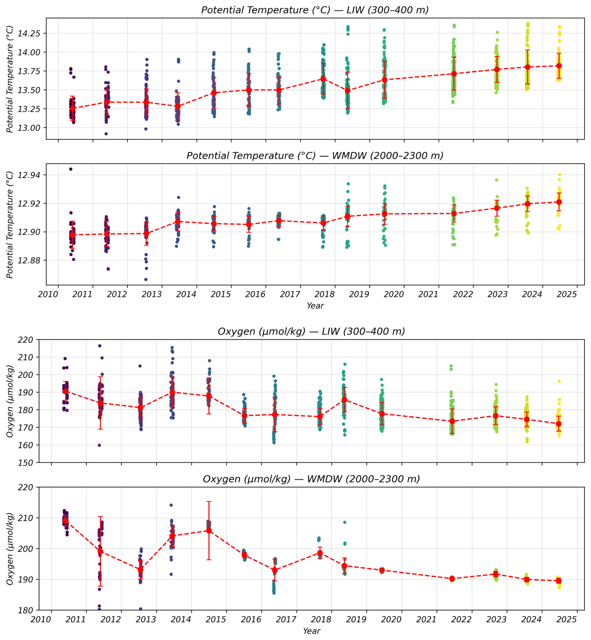
Figure 5Time series of potential temperature (top panel) and dissolved oxygen (bottom panel) at LIW and WMDW core depth levels (300–400 m and >2000 m, respectively). The color represents the year and the red dots the average value for each year with the standard deviation.
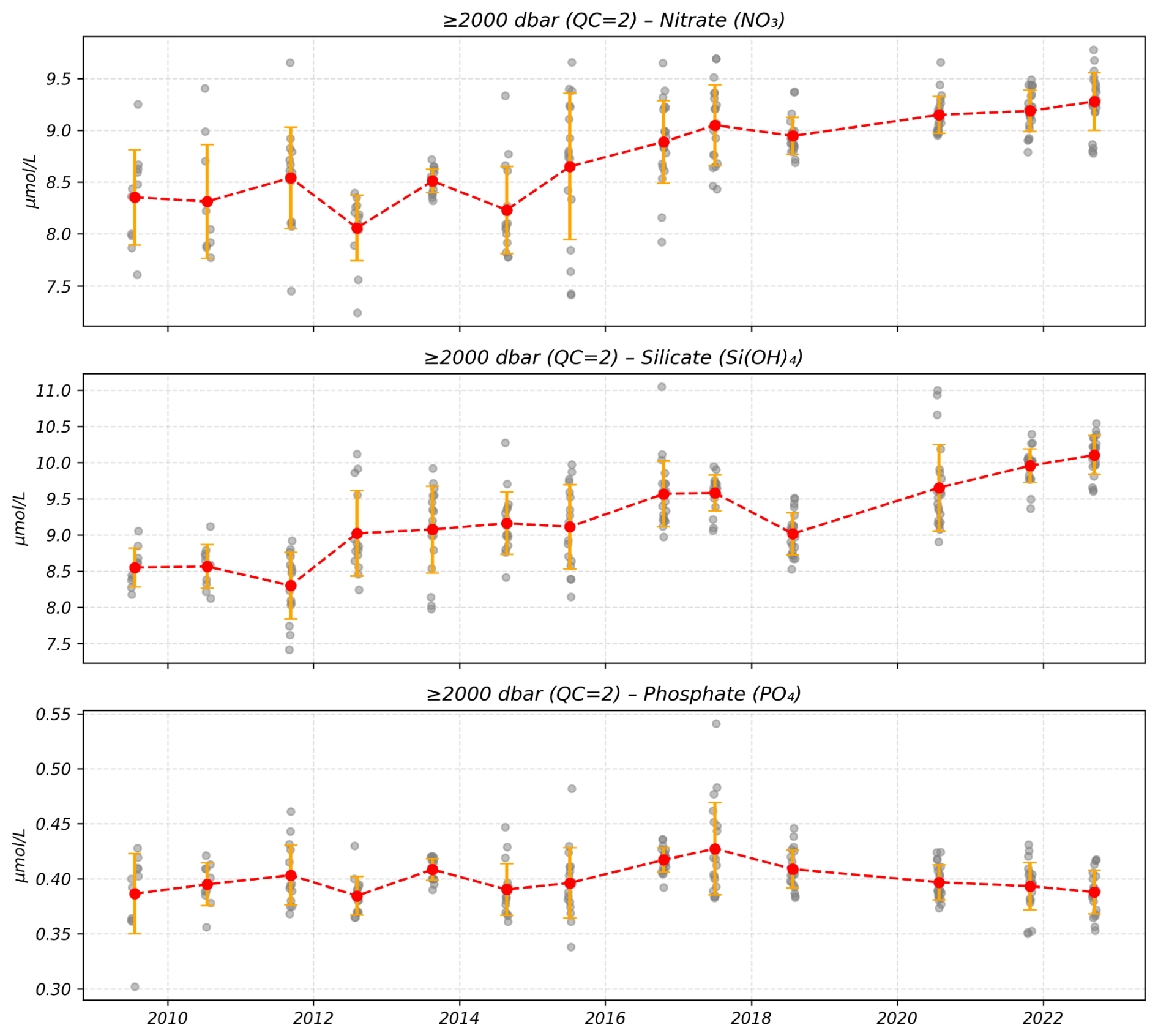
Figure 6Evolution of nutrients concentrations (in µmol L−1) in the deep waters (>2000 m) acquired during the MOOSE-GE cruises. The red dots represent the annual mean with the standard deviation.
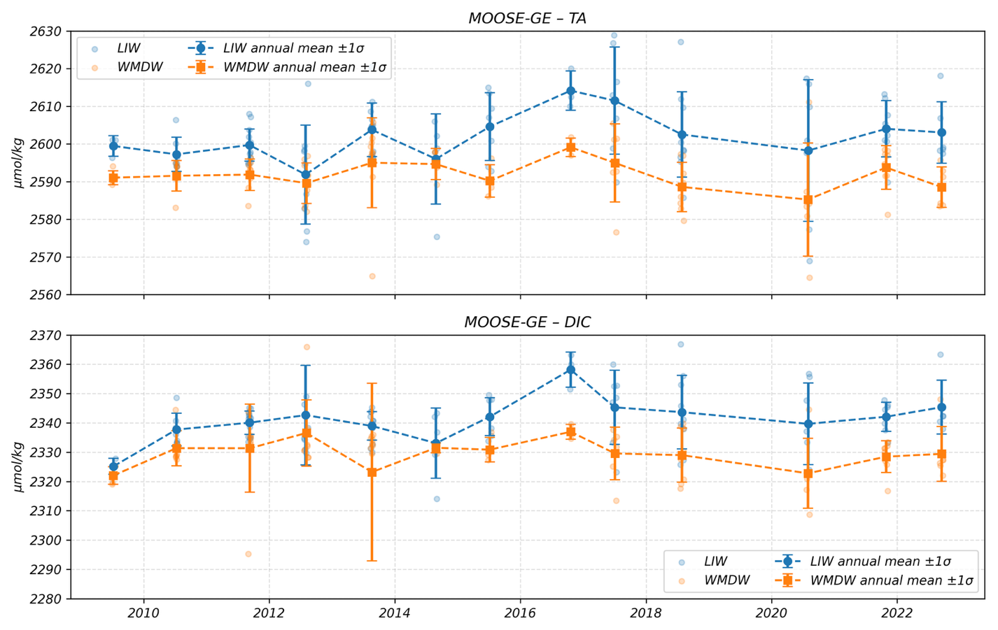
Figure 7Evolution of TA and DIC concentrations (in µmol kg−1) in the intermediate waters (400–600 m) in blue and in the deep waters (>2000 m) in orange acquired during the MOOSE-GE cruises. The dots represent the annual mean with the standard deviation (from MOOSE-GE cruise series report, https://doi.org/10.18142/235).
Table 3List of DOI for archived data in the framework of the MOOSE-GE cruises.
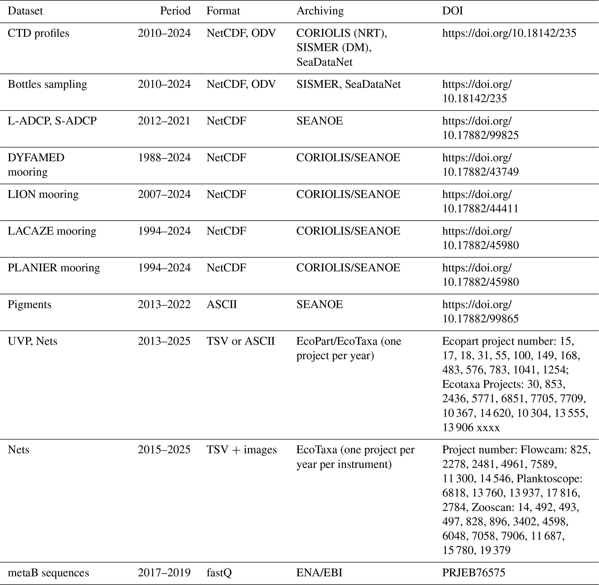
Table 4MOOSE-GE imaging datasets available on EcoTaxa (2012–2024).
4.3 Biodiversity variables
These analyses enable mapping of zooplankton biomass and abundance distributions, as well as taxonomic groups or even key species, and allow the study of spatial variations in relation to environmental parameters (Fig. 8). Imaging and taxonomic data from the DEWEX and MOOSE-GE 2014 and 2017 cruises distinguished three zooplankton groups based on integrated 0–200 m values: one corresponding mainly to Ligurian Sea stations, and two others located in the Northern and Southern parts of the Provençal basin, revealing a marked North-South gradient (Feliu, 2020). Zooplankton abundance and biomass in the Ligurian Sea and southern Provençal basin are relatively homogeneous, while the largest variations are observed on the Gulf of Lion slope and in the central Provençal basin. A holistic analysis of the 2017, 2018, and 2019 MOOSE-GE cruises combining integrated approaches environmental genomics and high-resolution imaging in relation to oceanographic features (Lescot et al., 2026; see Tables 2 and 3) showed that plankton community structure was primarily shaped by organism size and water column depth. Smaller size fractions (0.2–3 and 3–180 µm) collected by Niskin bottles in the surface and deep chlorophyll maximum layers exhibited the highest alpha diversity and were dominated by protists such as Syndiniales and Rhizaria, while larger fractions (>64 µm) from net tows were dominated by metazoans, particularly Arthropoda. Temporal differences between cruises were detected mainly in Niskin bottle samples, especially for diatoms and dinoflagellates, while net tow samples exhibited weaker temporal variability. Physical clustering of stations revealed clear cross-shelf and basin-scale gradients, which aligned more closely with community structure at fine taxonomic resolution (OTU level) for smaller fractions. It should be noted that these published results cover only three cruises (2017–2019) however new metabarcoding datasets from the four following campaigns (2021 to 2024) have just been recently sequenced; a substantially larger volume of UVP and net-based imaging data collected across the full MOOSE-GE time series (2012–present) remains available in EcoTaxa/EcoPart and represents a significant opportunity for future exploitation. Complementary results on siliceous Rhizaria diversity and distribution in the NW Mediterranean from MOOSE-GE cruises are also available in Llopis Monferrer et al. (2022).
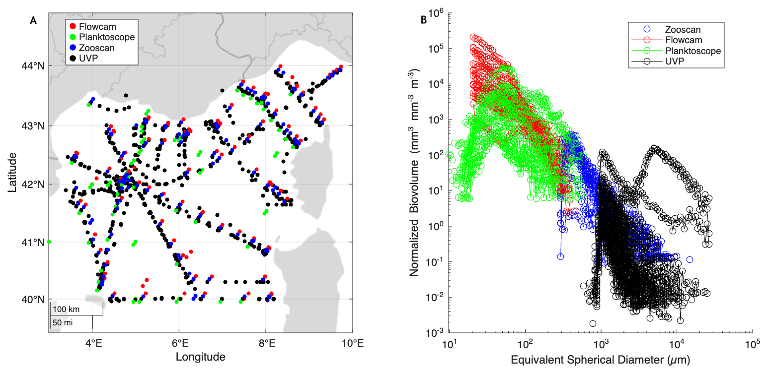
Figure 8(A) Localisation of the different samples obtained and covering the size spectra of living organisms from microplankton (Flowcam, Planktoscope), mesozooplankton (WP2 nets analysed through Zooscan) and macrozooplankton and marine snow particles observed in-situ through profiling camera (UVP). (B) Comparison of the normalized size spectra of living organisms obtained with the different devices during the MOOSE-GE 2024 cruise, demonstrating the complementarity of instruments in capturing the continuum of life forms.
4.4 Links to the modelling community
MOOSE has maintained strong links with the SIROCCO Community Code, particularly for products derived from the coupled SYMPHONIE ECO3M-S model (Marsaleix et al., 2008; Estournel et al., 2016). MOOSE network data are highly valuable as they cover several north–south transects across the basin on an annual basis, and high-frequency fixed-point time series encompassing the full water column. These data have notably enabled the validation and improvement of simulations of submesoscale frontal instabilities (Bosse et al., 2021), carbon production and export (Ulses et al., 2016; Kessouri et al., 2017; Many et al., 2021), nutrient cycles (Kessouri et al., 2018) dissolved O2 content (Ulses et al., 2021), as well as the simulation of the annual and seasonal budgets of dissolved inorganic carbon (DIC), during 2012–2013 (Ulses et al., 2023).
Looking ahead, simulation products developed and validated with MOOSE data, specifically aim to: (1) provide annual and seasonal simulations of the mixed layer depth, SST, nutrient, chlorophyll, O2 and air-sea CO2 fluxes, (2) extract time series at geolocated points for temperature, salinity, O2, nutrients, alkalinity, pH, and DIC in intermediate and deep waters, complementing in situ monthly observations and/or discontinuous datasets, (3) provide closed budget for heat, salt, carbon, nitrogen, phosphorus and oxygen, (4) propose, in collaboration with the SIROCCO Community Code, value-added products such as annual heatwave indicators, including the spatial extent and the depth of the water column affected by marine heatwaves and (5) help optimise ship time allocation by designing future cruise plans for MOOSE-GE cruises
In addition, MOOSE data are used as reference dataset for the development of ocean stand-alone and fully coupled regional climate models in particular within the international Med-CORDEX initiative (Ruti et al., 2016) and the national SiMED modelling group (https://confluence-meteofrance.atlassian.net/wiki/spaces/SiMED/overview, last access: 17 July 2026). More specifically, MOOSE datasets have served for model evaluation, calibration and selection as well as to create model initial conditions or blended climate indices mixing in-situ data, satellite and models for studies dedicated to the northwestern Mediterranean Sea. To cite some examples, MOOSE data (surface buoy, deep mooring, ARGO floats, gliders) have been used to create model initial 3D state for studying the 2012–2013 case study (Estournel et al., 2016; Waldman et al., 2017), to evaluate the model air-sea interface at the LION buoy (Waldman et al., 2017), deep water formation rate for the 2012–2013 year (Waldman et al., 2016), interannual variability of the yearly maximum mixed layer depths and convective surfaces (Somot et al., 2018), water column stratification (Somot et al., 2018), trends in bottom water mass characteristics (Somot et al., 2018), thermohaline cell downward branch along the bathymetry (Waldman et al., 2018).
The flow of data produced in real time or in delayed mode is considerable, and its management represents a true challenge for the observing system in terms of quality control (QC), formatting, archiving, and integration into databases. As the MOOSE program is embedded in a national context (with research infrastructures linked to DATA TERRA and the marine hub ODATIS), a European context (ERICs), and an international framework of observation efforts (EUROGOOS and GOOS), its data component naturally follows the international standards recommended at these levels (e.g., EMODnet). This ensures greater interoperability between databases, broad dissemination, and consequently better scientific exploitation of these observations. Interoperability is crucial both at the organizational level within MOOSE (integration of multi-site data) and at the European and international levels (recognition and increased collaboration potential). Existing protocols (quality control procedures, data formats, interoperability standards), already established through consensus in international and European projects, have therefore been adopted by the MOOSE network.
Data presented in this study (Table 3) are available from SISMER https://doi.org/10.18142/235 (Coppola et al., 2010) and from SEANOE: https://doi.org/10.17882/99825 (Bosse et al., 2024a), https://doi.org/10.17882/44411 (Bosse et al., 2025), https://doi.org/10.17882/45980 (Durrieu de Madron et al., 2024), https://doi.org/10.17882/43749 (Coppola et al., 2025), https://doi.org/10.17882/99865 (Dimier et al., 2024).
For data processing and archiving of the cruises, MOOSE relies on the effort of national data centers and the ODATIS data hub of the DATA TERRA RI. In particular:
-
CTD casts profiles are transmitted in near-real time directly to the CORIOLIS Global Data Assembly Center (GDAC) for operational oceanography. It includes temperature, salinity, and oxygen profiles collected and processed onboard. CTD data is transmitted within a short delay (<24 h, but usually <1 h) after SBE automated processing, then qualified and stored following Coriolis real-time standards. This operational task has been automated by a cruise server developed during the MOOSE-GE cruises and installed on the ship's network allowing for a centralisation, and easy access of all stations data sets. Once the cruise is finished, the server's data are imported online to be archived (https://www.medship.org/doku.php, last access: 17 July 2026).
-
CTD casts profiles, bottles and mooring data are transmitted in delayed-mode (DM) after sample analyses and S and O2 sensors adjustment (with seawater sampling and cross-validation for mooring sensors). Processing can take several months, and in some cases more than a year for Niskin samples. Once QC and validation are complete, data is transferred to the SISMER center for cruise-based data, and to Coriolis for mooring data (OceanSites/EMSO format).
-
Additional datasets, such as L-ADCP, chlorophyll pigments (HPLC) are also available via SEANOE landing pages. This provides several advantages: (1) access to detailed metadata, (2) rapid DOI assignment, (3) fast availability of data in multiple formats, with the possibility of later updates, and (4) automatic generation of a list of publications using or referencing the dataset. This type of repository is also valuable for revised compilations of legacy datasets. SEANOE provides access to data not archived by SISMER despite being collected during cruises (non-standard SISMER data format).
For imagery data (UVP5, Zooscan), processing (taxonomic sorting) and storage are carried out through the web application EcoTaxa (Picheral et al., 2025), which subsequently enables data dissemination to aggregators such as EMODnet and OBIS. Particle counts, concentrations and obtained identifications (if available) from UVP profiles are also directly downloadable from EcoPart. Processing efficiency is partly ensured through machine learning: users can train models based on prior identifications in the database to suggest labels for newly uploaded images. By combining deep-learning feature extractors, a fast-training classifier, and sufficient flexibility to build task-specific models, EcoTaxa achieves classification performances comparable to state-of-the-art deep learning networks, while remaining usable within minutes by taxonomists with no background in computer science. For environmental genomics, raw data are deposited in the European Nucleotide Archive (ENA) and subsequently integrated into the “Ocean Barcode Atlas” server (OBA; Vernette et al., 2021), together with associated environmental (physical and chemical) metadata. In coordination with national initiatives (FUTURE-OBS) and European ones (EMO-BON), a sequencing data processing pipeline (meta-barcoding) has been developed to ensure both the reproducibility of analyses for future sample processing and the interoperability of different biodiversity data types (sequences and images).
The MOOSE-GE cruise series constitutes a cornerstone of sustained, basin-scale observation in the northwestern Mediterranean Sea, providing a unique, internally consistent record (2010–2024) of physical, biogeochemical and biodiversity Essential Ocean Variables from the surface to the seafloor. This observing effort is exceptional in scope and continuity: no equivalent exists in the Mediterranean basin that combines the annual repetition of a large standardized multi-disciplinary cruise, the integration of multiple variables across the full water column, and the systematic inter-calibration with deep moorings and autonomous platforms. Maintaining this capability is critical to resolve long-term trends and interannual variability across key processes from deep convection and water-mass transformation to oxygenation, nutrient and carbon-cycle dynamics, and ecosystem responses, especially as climate-driven impacts intensify. Regular cruises remain essential alongside autonomous platforms (Argo floats, gliders, moorings), as only shipborne operations can ensure sensor cross-calibration, sediment-trap sample recovery, and biological collection that no autonomous system can replace. Such sustained basin-scale surveys should therefore be regarded as a mandatory component of institutional and European observing strategies, requiring strong, long-term support from oceanographic fleets and research infrastructures. Looking ahead, Observing System Simulation Experiment (OSSE) approaches will be explored to optimise ship time allocation, station density, and vertical sampling resolution, while maintaining the key north–south transects that are central to MOOSE-GE scientific objectives. Only with this level of commitment, and careful documentation of trade-offs between observational cost and scientific priorities, can the community deliver robust, timely and quantitative assessments and early-warning signals for the Mediterranean Sea.
LC coordinates the MOOSE program and the annual MOOSE-GE cruises with PT and AB. TW, DL, ML, FC, FL, FC, XDM, MPJ, PC participate actively in the cruise's preparation, analysis on board and data treatment. ER, CL, ML, MG, PB, SK, JS and SN lead the instruments deployment, maintenance, samples collection and data analysis and treatment. CU, CE and SS assist for model simulations and cruise scenarios.
The contact author has declared that none of the authors has any competing interests.
Publisher's note: Copernicus Publications remains neutral with regard to jurisdictional claims made in the text, published maps, institutional affiliations, or any other geographical representation in this paper. The authors bear the ultimate responsibility for providing appropriate place names. Views expressed in the text are those of the authors and do not necessarily reflect the views of the publisher.
The authors wish to pay tribute to the memory of two pillars of MOOSE program. Pascal Conan, who passed away on 5 August 2025. He made insightful contributions and was unwaveringly dedicated to biogeochemical oceanography. We will miss him both professionally and personally. Francois Carlotti, who passed away on 3 January 2026. He was a marine biologist, whose contributions and commitment will be deeply missed. We acknowledge the sustained financial support from CNRS and the national research infrastructures ILICO and EMSO-France, as well as the essential contribution of the French Oceanographic Fleet (FOF) for providing access to research vessels. We also acknowledge the SNAPO-CO2 facility supported by INSU/CNRS and OSU ECCE-Terra for the AT DIC analysis. We warmly thank all staff from the partner laboratories of the SNO MOOSE network for their commitment at every stage of the program, from cruise preparation and field operations to sample processing, analyses, and data quality control. Finally, we acknowledge the SISMER and Coriolis data-management teams, and the support of the ODATIS data hub, whose efforts are critical to ensuring long-term stewardship, interoperability, and open access to the MOOSE-GE datasets.
The MOOSE program is supported by CNRS-INSU and by the French research infrastructures ILICO and EMSO-France (French Ministry of Higher Education and Research). Additional support was provided by the FUTURE-OBS project (Augmented Observatories for Coastal Socio-Ecosystems; ANR-22-POCE-0004), which funded part of the genomic analyses, and by the RIOMAR project (Observing and Anticipating the Evolution of River-Dominated Ocean Margins in the 21st Century; ANR-22-POCE-0006), which supported part of the biogeochemical analyses.
This paper was edited by François G. Schmitt and reviewed by Giuseppe M. R. Manzella, Francesco Paladini de Mendoza, and one anonymous referee.
Aminot, A. and Kérouel, R.: Dosage automatique des nutriments dans les eaux marines: méthodes en flux continu, Éditions Ifremer, Méthodes d'analyse en milieu marin, 188 pp., ISBN 2-7592-0023-X, 2007.
Astraldi, M., Gasparini, G. P., and Sparnocchia, S.: The Seasonal and Interannual Variability in the Ligurian-Provençal Basin, in: Seasonal and Interannual Variability of the Western Mediterranean Sea, Coastal and Estuarine Studies, Vol. 46, edited by: La Violette, P. E., AGU – American Geophysical Union, Washington, D.C., 93–113, ISBN 978-1-118-66503-9, 1994.
Belgacem, M., Schroeder, K., Barth, A., Troupin, C., Pavoni, B., Raimbault, P., Garcia, N., Borghini, M., and Chiggiato, J.: Climatological distribution of dissolved inorganic nutrients in the western Mediterranean Sea (1981–2017), Earth Syst. Sci. Data, 13, 5915–5949, https://doi.org/10.5194/essd-13-5915-2021, 2021.
Béthoux, J. P. and Gentili, B.: Functioning of the Mediterranean Sea: past and present changes related to freshwater input and climate changes, J. Marine Syst., 18, 33–54, https://doi.org/10.1016/S0924-7963(98)00069-4, 1999.
Béthoux, J. P., Gentili, B., Raunet, J., and Tailliez, D.: Warming trend in the western Mediterranean deep water, Nature, 347, 660–662, https://doi.org/10.1038/347660a0, 1990.
Beuvier, J., Béranger, K., Lebeaupin Brossier, C., Somot, S., Sevault, F., Drillet, Y., Bourdallé-Badie, R., Ferry, N., and Lyard, F.: Spreading of the Western Mediterranean Deep Water after winter 2005: time scales and deep cyclone transport, J. Geophys. Res., 117, C07022, https://doi.org/10.1029/2011JC007679, 2012.
Bosse, A., Testor, P., Houpert, L., Damien, P., Prieur, L., Hayes, D., Taillandier, V., Durrieu de Madron, X., D'Ortenzio, F., Coppola, L., Karstensen, J., and Mortier, L.: Scales and dynamics of submesoscale coherent vortices formed by deep convection in the northwestern Mediterranean Sea, J. Geophys. Res.-Oceans, 121, 7716–7742, https://doi.org/10.1002/2016JC012144, 2016.
Bosse, A., Testor, P., Mayot, N., Prieur, L., D'Ortenzio, F., Mortier, L., Le Goff, H., Gourcuff, C., Coppola, L., Lavigne, H., and Raimbault, P.: A submesoscale coherent vortex in the Ligurian Sea: from dynamical barriers to biological implications, J. Geophys. Res.-Oceans, 122, 6196–6217, https://doi.org/10.1002/2016JC012634, 2017.
Bosse, A., Testor, P., Damien, P., Estournel, C., Marsaleix, P., Mortier, L., Prieur, L., and Taillandier, V.: Wind-forced submesoscale symmetric instability around deep convection in the northwestern Mediterranean Sea, Fluids, 6, 123, https://doi.org/10.3390/fluids6030123, 2021.
Bosse, A., Bretel, P., Le Goff, H., and Testor, P.: MOOSE-GE cruises: lowered and ship ADCP data, SEANOE [data set], https://doi.org/10.17882/99825, 2024a.
Bosse, A., Lenne, J., Testor, P., Lefèvre, D., and Durrieu de Madron, X.: Warming of Western Mediterranean Deep Water in the context of halted deep convection, CIESM Congress 2024, Palermo, Italy, October 2024, HAL-04798803, 2024b.
Bosse, A., Testor, P., Coppola, L., Bretel, P., Dausse, D., Durrieu de Madron, X., Houpert, L., Labaste, M., Le Goff, H., Mortier, L., and D'Ortenzio, F.: LION observatory data, SEANOE [data set], https://doi.org/10.17882/44411, 2025.
Clayton, T. D. and Byrne, R. H.: Spectrophotometric seawater pH measurements: total hydrogen ion concentration scale calibration of m-cresol purple and at-sea results, Deep-Sea Res. Pt. I, 40, 2115–2129, https://doi.org/10.1016/0967-0637(93)90048-8, 1993.
Cocquempot, L., Delacourt, C., Paillet, J., Riou, P., Aucan, J., Castelle, B., Charria, G., Claudet, J., Conan, P., Coppola, L., Hocdé, R., Planes, S., Raimbault, P., Savoye, N., Testut, L., and Vuillemin, R.: Coastal ocean and nearshore observation: a French case study, Front. Mar. Sci., 6, 324, https://doi.org/10.3389/fmars.2019.00324, 2019.
Conan, P., Testor, P., Estournel, C., D'Ortenzio, F., and Pujo-Pay, M.: Preface to the special section: dense water formations in the northwestern Mediterranean: from the physical forcings to the biogeochemical consequences, J. Geophys. Res.-Oceans, 123, 6749–6751, https://doi.org/10.1029/2018JC014301, 2018.
Coppola, L., Bosse, A., and Testor, P.: MOOSE-GE, French Oceanographic Cruises [data set], https://doi.org/10.18142/235, 2010.
Coppola, L., Ntoumas, M., Bozzano, R., Bensi, M., Hartman, S. E., Charcos Llorens, M., Craig, J., Rolin, J.-F., Giovanetti, G., Cano, D., Karstensen, J., Cianca, A., Toma, D., Stasch, C., Pensieri, S., Cardin, V., Tengberg, A., Petihakis, G., and Cristini, L.: Handbook of best practices for open ocean fixed observatories, European Commission, FixO3 Project, 127 pp., https://doi.org/10.25607/OBP-1488, 2016.
Coppola, L., Prieur, L., Taupier-Letage, I., Estournel, C., Testor, P., Lefèvre, D., Belamari, S., LeReste, S., and Taillandier, V.: Observation of oxygen ventilation into deep waters through targeted deployment of multiple Argo-O2 floats in the north-western Mediterranean Sea in 2013, J. Geophys. Res.-Oceans, 122, 6325–6341, https://doi.org/10.1002/2016JC012594, 2017.
Coppola, L., Legendre, L., Lefèvre, D., Prieur, L., Taillandier, V., and Diamond Riquier, E.: Seasonal and inter-annual variations of dissolved oxygen in the northwestern Mediterranean Sea (DYFAMED site), Prog. Oceanogr., 162, 187–201, https://doi.org/10.1016/j.pocean.2018.03.001, 2018.
Coppola, L., Raimbault, P., Mortier, L., and Testor, P.: Monitoring the environment in the northwestern Mediterranean Sea, Eos, 100, https://doi.org/10.1029/2019EO125951, 2019.
Coppola, L., Boutin, J., Gattuso, J.-P., Lefèvre, D., and Metzl, N.: The carbonate system in the Ligurian Sea, in: The Mediterranean Sea in the Era of Global Change 1: 30 Years of Multidisciplinary Study of the Ligurian Sea, edited by: Migon, C., Nival, P., and Sciandra, A., ISTE Science Publishing, London, 79–104, https://doi.org/10.1002/9781119706960.ch4, 2020.
Coppola, L., Diamond Riquier, E., Carval, T., Irisson, J.-O., and Desnos, C.: DYFAMED observatory data, SEANOE [data set], https://doi.org/10.17882/43749, 2025.
Cossarini, G., Lazzari, P., and Solidoro, C.: Spatiotemporal variability of alkalinity in the Mediterranean Sea, Biogeosciences, 12, 1647–1658, https://doi.org/10.5194/bg-12-1647-2015, 2015.
Cramer, W., Guiot, J., Fader, M., Garrabou, J., Gattuso, J.-P., Iglesias, A., Lange, M. A., Lionello, P., Llasat, M. C., Paz, S., Peñuelas, J., Snoussi, M., Toreti, A., Tsimplis, M. N., and Xoplaki, E.: Climate change and interconnected risks to sustainable development in the Mediterranean, Nat. Clim. Change, 8, 972–980, https://doi.org/10.1038/s41558-018-0299-2, 2018.
Darmaraki, S., Somot, S., Sevault, F., Nabat, P., Cabos Narvaez, W. D., Cavicchia, L., Djurdjevic, V., Li, L., Sannino, G., and Sein, D. V.: Future evolution of marine heatwaves in the Mediterranean Sea, Clim. Dynam., 53, 1371–1392, https://doi.org/10.1007/s00382-019-04661-z, 2019.
Dickson, A. G. and Goyet, C. (Eds.): Handbook of methods for the analysis of the various parameters of the carbon dioxide system in sea water, Version 2, ORNL/CDIAC-74, Oak Ridge National Laboratory, Oak Ridge, Tennessee, 198 pp., https://doi.org/10.2172/10107773, 1994.
Dickson, A. G., Sabine, C. L., and Christian, J. R. (Eds.): Guide to best practices for ocean CO2 measurements, PICES Special Publication 3, 191 pp., https://doi.org/10.25607/OBP-1342, 2007.
Dimier, C., Ras, J., Claustre, H., and Uitz, J.: MOOSE_GE cruises: phytoplankton pigments, SEANOE [data set], https://doi.org/10.17882/99865, 2024.
D'Ortenzio, F. and Ribera d'Alcalà, M.: On the trophic regimes of the Mediterranean Sea: a satellite analysis, Biogeosciences, 6, 139–148, https://doi.org/10.5194/bg-6-139-2009, 2009.
Durrieu de Madron, X., Ramondenc, S., Berline, L., Houpert, L., Bosse, A., Martini, S., Guidi, L., Conan, P., Curtil, C., Delsaut, N., Kunesch, S., Ghiglione, J. F., Marsaleix, P., Pujo-Pay, M., Severin, T., Testor, P., Tamburini, C., and the ANTARES Collaboration: Deep sediment resuspension and thick nepheloid layer generation by open-ocean convection, J. Geophys. Res.-Oceans, 122, 2291–2318, https://doi.org/10.1002/2016JC012062, 2017.
Durrieu de Madron, X., Heussner, S., Delsaut, N., Kunesch, S., and Menniti, C.: BILLION observatory data, SEANOE [data set], https://doi.org/10.17882/45980, 2024.
Edmond, J. M.: High precision determination of titration alkalinity and total carbon dioxide content of sea water by potentiometric titration, Deep-Sea Res., 17, 737–750, https://doi.org/10.1016/0011-7471(70)90038-0, 1970.
Escudier, R., Renault, L., Pascual, A., Brasseur, P., Chelton, D., and Beuvier, J.: Eddy properties in the Western Mediterranean Sea from satellite altimetry and a numerical simulation, J. Geophys. Res.-Oceans, 121, 3990–4006, https://doi.org/10.1002/2015JC011371, 2016.
Estournel, C., Testor, P., Damien, P., D'Ortenzio, F., Marsaleix, P., Conan, P., Kessouri, F., Durrieu de Madron, X., Coppola, L., Lellouche, J.-M., Belamari, S., Mortier, L., Ulses, C., Bouin, M.-N., and Prieur, L.: High resolution modeling of dense water formation in the north-western Mediterranean during winter 2012–2013: processes and budget, J. Geophys. Res.-Oceans, 121, 5367–5392, https://doi.org/10.1002/2016JC011935, 2016.
Feliu, G.: Étude de la structure communautaire et du rôle trophique du mésozooplancton en Méditerranée lors de deux campagnes océanographiques de grande échelle PEACETIME et MOOSE en 2017, Ph.D. thesis, Aix-Marseille Université, France, https://doi.org/10.70675/8de410fdzfb09z4413zb12fze956654c8ba6, 2020.
Fourrier, M., Coppola, L., Claustre, H., D'Ortenzio, F., Sauzède, R., and Gattuso, J.-P.: A regional neural network approach to estimate water-column nutrient concentrations and carbonate system variables in the Mediterranean Sea: CANYON-MED, Front. Mar. Sci., 7, 620, https://doi.org/10.3389/fmars.2020.00620, 2020.
Fourrier, M., Coppola, L., D'Ortenzio, F., Migon, C., and Gattuso, J.-P.: Impact of intermittent convection in the northwestern Mediterranean Sea on oxygen content, nutrients, and the carbonate system, J. Geophys. Res.-Oceans, 127, e2022JC018615, https://doi.org/10.1029/2022JC018615, 2022.
Giorgi, F.: Climate change hot-spots, Geophys. Res. Lett., 33, L08707, https://doi.org/10.1029/2006GL025734, 2006.
Guinaldo, T., Voldoire, A., Waldman, R., Saux Picart, S., and Roquet, H.: Response of the sea surface temperature to heatwaves during the France 2022 meteorological summer, Ocean Sci., 19, 629–647, https://doi.org/10.5194/os-19-629-2023, 2023.
Harris, R., Wiebe, P., Lenz, J., Skjoldal, H. R., and Huntley, M. (Eds.): ICES Zooplankton Methodology Manual, Academic Press, London, ISBN 9780123276452, 2000.
Hebden, M. and Buck, J.: SeaDataNet data management protocols for glider data, D.9.14, Version 1.2, SeaDataNet, 33 pp., https://doi.org/10.25607/OBP-1870, 2019.
Heimbürger, L.-E., Lavigne, H., Migon, C., D'Ortenzio, F., Estournel, C., Coppola, L., and Miquel, J.-C.: Temporal variability of vertical export flux at the DYFAMED time-series station (northwestern Mediterranean Sea), Prog. Oceanogr., 119, 59–67, https://doi.org/10.1016/j.pocean.2013.08.005, 2013.
Herrmann, M., Auger, P.-A., Ulses, C., and Estournel, C.: Long-term monitoring of ocean deep convection using multisensors altimetry and ocean color satellite data, J. Geophys. Res.-Oceans, 122, 1457–1475, 2017.
Holmes, R. M., Aminot, A., Kérouel, R., Hooker, B. A., and Peterson, B. J.: A simple and precise method for measuring ammonium in marine and freshwater ecosystems, Can. J. Fish. Aquat. Sci., 56, 1801–1808, https://doi.org/10.1139/f99-128, 1999.
Houpert, L., Durrieu de Madron, X., Testor, P., Bosse, A., D'Ortenzio, F., Bouin, M.-N., Dausse, D., Le Goff, H., Kunesch, S., Labaste, M., Coppola, L., Mortier, L., and Raimbault, P.: Observations of open-ocean deep convection in the northwestern Mediterranean Sea: seasonal and interannual variability of mixing and deep water masses for the 2007–2013 period, J. Geophys. Res.-Oceans, 121, 8139–8171, https://doi.org/10.1002/2016JC011857, 2016.
IPCC: Climate Change 2022: Mitigation of Climate Change. Contribution of Working Group III to the Sixth Assessment Report of the Intergovernmental Panel on Climate Change, Cambridge University Press, Cambridge, UK and New York, NY, USA, https://doi.org/10.1017/9781009157926, 2022.
Irisson, J.-O., Salinas, L., Colin, S., Complex Team, and Picheral, M.: EcoTaxa: a tool to support the taxonomic classification of large datasets through supervised machine learning, SFEcologie 2022, Metz, France, Metz, hal-04026447, 2022.
Ivanovic, R. F., Valdes, P. J., Gregoire, L., Flecker, R., and Gutjahr, M.: Sensitivity of modern climate to the presence, strength and salinity of Mediterranean–Atlantic exchange in a global general circulation model, Clim. Dynam., 42, 859–877, https://doi.org/10.1007/s00382-013-1680-5, 2014.
Jalabert, L., Elineau, A., Brandão, M., and Picheral, M.: Zooscan-Zooprocess user manual and procedures at the Quantitative Imaging Platform of Villefranche-sur-Mer (PIQv) (1.3), Zenodo, https://doi.org/10.5281/zenodo.15114134, 2025a.
Jalabert, L., Lombard, F., and Picheral, M.: FlowCam Zooprocess user manual and procedures at the Quantitative Imaging Platform of Villefranche-sur-Mer (PIQv), Zenodo, https://doi.org/10.5281/zenodo.15113735, 2025b.
Josey, S. A. and Schroeder, K.: Declining winter heat loss threatens continuing ocean convection at a Mediterranean dense water formation site, Environ. Res. Lett., 18, 024005, https://doi.org/10.1088/1748-9326/aca9e4, 2023.
Kassis, D., Nittis, K., and Perivoliotis, L.: Hydrodynamic variability based on the multi-parametric POSEIDON Pylos observatory of the south Ionian Sea, Ocean Sci. Discuss., 10, 883–921, https://doi.org/10.5194/osd-10-883-2013, 2013.
Kermabon, C., Lherminier, P., and Le Bot, P.: CASCADE V7.2: Software for processing, qualifying and visualizing SADCP data, User's guide, https://doi.org/10.13155/100082, 2023.
Kessouri, F., Ulses, C., Estournel, C., Marsaleix, P., Severin, T., Pujo-Pay, M., Caparros, J., Raimbault, P., Pasqueron de Fommervault, O., D'Ortenzio, F., Taillandier, V., Testor, P., and Conan, P.: Nitrogen and phosphorus budgets in the Northwestern Mediterranean deep convection region, J. Geophys. Res.-Oceans, 122, https://doi.org/10.1002/2016JC012665, 2017.
Kessouri, F., Ulses, C., Estournel, C., Marsaleix, P., D'Ortenzio, F., Severin, T., Taillandier, V., and Conan, P.: Vertical mixing effects on phytoplankton dynamics and organic carbon export in the western Mediterranean Sea, J. Geophys. Res.-Oceans, 123, 1647–1669, https://doi.org/10.1002/2016JC012669, 2018.
Kiko, R., Picheral, M., Antoine, D., Babin, M., Berline, L., Biard, T., Boss, E., Brandt, P., Carlotti, F., Christiansen, S., Coppola, L., de la Cruz, L., Diamond-Riquier, E., Durrieu de Madron, X., Elineau, A., Gorsky, G., Guidi, L., Hauss, H., Irisson, J.-O., Karp-Boss, L., Karstensen, J., Kim, D., Lekanoff, R. M., Lombard, F., Lopes, R. M., Marec, C., McDonnell, A. M. P., Niemeyer, D., Noyon, M., O'Daly, S. H., Ohman, M. D., Pretty, J. L., Rogge, A., Searson, S., Shibata, M., Tanaka, Y., Tanhua, T., Taucher, J., Trudnowska, E., Turner, J. S., Waite, A., and Stemmann, L.: A global marine particle size distribution dataset obtained with the Underwater Vision Profiler 5, Earth Syst. Sci. Data, 14, 4315–4337, https://doi.org/10.5194/essd-14-4315-2022, 2022.
Krahmann, G. and Schott, F.: Long-term increases in Western Mediterranean salinities and temperatures: anthropogenic and climatic sources, Geophys. Res. Lett., 25, 4209–4212, 1998.
Krom, M. D., Herut, B., and Mantoura, R. F. C.: Nutrient budget for the Eastern Mediterranean: implications for phosphorus limitation, Limnol. Oceanogr., 49, 1582–1592, https://doi.org/10.4319/lo.2004.49.5.1582, 2004.
Lejeusne, C., Chevaldonné, P., Pergent-Martini, C., Boudouresque, C. F., and Pérez, T.: Climate change effects on a miniature ocean: the highly diverse, highly impacted Mediterranean Sea, Trends Ecol. Evol., 25, 250–260, 2010.
Lescot, M., Lezzoche, N., Laux, L., Romac, S., Guilloux, L., Chevillon, E., Bodson, C., Desnos, C., Elineau, A., Jalabert, L., Llopis Monferrer, N., Mendez Sandin, M., Vannier, T., Vernette, C., Villar, E., Lombard, F., Carlotti, F., Irisson, J.-O., Guidi, L., Bosse, A., Testor, P., Coppola, L., and Not, F.: A holistic perspective on planktonic communities across the Northwestern Mediterranean Sea, Front. Mar. Sci., 13, 1755855, https://doi.org/10.3389/fmars.2026.1755855, 2026.
Liu, X., Patsavas, M. C., and Byrne, R. H.: Purification and characterization of meta-cresol purple for spectrophotometric seawater pH measurements, Environ. Sci. Technol., 45, 4862–4868, https://doi.org/10.1021/es200665d, 2011.
Llopis Monferrer, N., Biard, T., Sandin, M. M., Lombard, F., Picheral, M., Elineau, A., Guidi, L., Leynaert, A., Tréguer, P., and Not, F.: Siliceous Rhizaria abundances and diversity in the Mediterranean Sea assessed by combined imaging and metabarcoding approaches, Front. Mar. Sci., 9, 895995, https://doi.org/10.3389/fmars.2022.895995, 2022.
Many, G., Ulses, C., Estournel, C., and Marsaleix, P.: Particulate organic carbon dynamics in the Gulf of Lion shelf (NW Mediterranean) using a coupled hydrodynamic–biogeochemical model, Biogeosciences, 18, 5513–5538, https://doi.org/10.5194/bg-18-5513-2021, 2021.
Margirier, F., Testor, P., Heslop, E., Mallil, K., Bosse, A., Houpert, L., Mortier, L., Bouin, M. N., Coppola, L., D'Ortenzio, F., Durrieu de Madron, X., Mourre, B., Prieur, L., Raimbault, P., and Taillandier, V.: Abrupt warming and salinification of intermediate waters interplays with decline of deep convection in the Northwestern Mediterranean Sea, Sci. Rep., 10, 20923, 2020.
Marsaleix, P., Auclair, F., Floor, J. W., Herrmann, M. J., Estournel, C., Pairaud, I., and Ulses, C.: Energy conservation issues in sigma-coordinate free-surface ocean models, Ocean Model., 20, 61–89, https://doi.org/10.1016/j.ocemod.2007.07.005, 2008.
Mayot, N., D'Ortenzio, F., Taillandier, V., Prieur, L., de Fommervault, O. P., Claustre, H., Bosse, A., Testor, P., and Conan, P.: Physical and biogeochemical controls of the phytoplankton blooms in North Western Mediterranean Sea: a multiplatform approach over a complete annual cycle (2012–2013 DEWEX experiment), J. Geophys. Res.-Oceans, 122, 9999–10019, 2017.
McTaggart, K. E., Johnson, G. C., Delahoyde, M. C., and Swift, J. H.: Notes on CTD/O2 data acquisition and processing using Sea-Bird hardware and software (as available), in: The GO-SHIP Repeat Hydrography Manual: A Collection of Expert Reports and Guidelines, Version 1, edited by: Hood, E. M., Sabine, C. L., and Sloyan, B. M., IOCCP Report Number 14, ICPO Publication Series Number 134, 10 pp., https://doi.org/10.25607/OBP-1348, 2010.
MedECC: Climate and Environmental Change in the Mediterranean Basin – Current Situation and Risks for the Future, First Mediterranean Assessment Report, edited by: Cramer, W., Guiot, J., and Marini, K., Union for the Mediterranean, Plan Bleu, UNEP/MAP, Marseille, France, 632 pp., ISBN 978-2-9577416-0-1, https://doi.org/10.5281/zenodo.4768833, 2020.
Merlivat, L., Boutin, J., Antoine, D., Beaumont, L., Golbol, M., and Vellucci, V.: Increase of dissolved inorganic carbon and decrease in pH in near-surface waters in the Mediterranean Sea during the past two decades, Biogeosciences, 15, 5653–5662, https://doi.org/10.5194/bg-15-5653-2018, 2018.
Metzl, N., Fin, J., Lo Monaco, C., Mignon, C., Alliouane, S., Antoine, D., Bourdin, G., Boutin, J., Bozec, Y., Conan, P., Coppola, L., Diaz, F., Douville, E., Durrieu de Madron, X., Gattuso, J.-P., Gazeau, F., Golbol, M., Lansard, B., Lefèvre, D., Lefèvre, N., Lombard, F., Louanchi, F., Merlivat, L., Olivier, L., Petrenko, A., Petton, S., Pujo-Pay, M., Rabouille, C., Reverdin, G., Ridame, C., Tribollet, A., Vellucci, V., Wagener, T., and Wimart-Rousseau, C.: A synthesis of ocean total alkalinity and dissolved inorganic carbon measurements from 1993 to 2022: the SNAPO-CO2-v1 dataset, Earth Syst. Sci. Data, 16, 89–120, https://doi.org/10.5194/essd-16-89-2024, 2024.
Millot, C.: Circulation in the Western Mediterranean Sea, J. Marine Syst., 20, 423–442, https://doi.org/10.1016/S0924-7963(98)00078-5, 1999.
Miquel, J.-C., Martín, J., Gasser, B., Rodriguez-y-Baena, A., Toubal, T., and Fowler, S. W.: Dynamics of particle flux and carbon export in the northwestern Mediterranean Sea: a two decade time-series study at the DYFAMED site, Prog. Oceanogr., 91, 461–481, https://doi.org/10.1016/j.pocean.2011.07.018, 2011.
Moon, J.-Y., Lee, K., Tanhua, T., Kress, N., and Kim, I.-N.: Temporal nutrient dynamics in the Mediterranean Sea in response to anthropogenic inputs, Geophys. Res. Lett., 43, 5243–5251, https://doi.org/10.1002/2016GL069483, 2016.
Mourre, B., Clementi, E., Coppini, G., Coppola, L., Korres, G., Novellino, A., Álvarez-Fanjul, E., Daniel, P., Zodiatis, G., Schroeder, K., and Tintoré, J.: Mediterranean observing and forecasting systems, in: Oceanography of the Mediterranean Sea, edited by: Schroeder, K. and Chiggiato, J., Elsevier, 335–386, https://doi.org/10.1016/B978-0-12-823692-5.00001-7, 2023.
Parras-Berrocal, I. M., Vázquez, R., Cabos, W., Sein, D. V., Álvarez, O., Bruno, M., and Izquierdo, A.: Surface and intermediate water changes triggering the future collapse of deep water formation in the North Western Mediterranean, Geophys. Res. Lett., 49, e2021GL095404, https://doi.org/10.1029/2021GL095404, 2022.
Pasqueron de Fommervault, O., Migon, C., D'Ortenzio, F., Ribera d'Alcalà, M., and Coppola, L.: Temporal variability of nutrient concentrations in the northwestern Mediterranean sea (DYFAMED time-series station), Deep-Sea Res. Pt. I, 100, 1–12, https://doi.org/10.1016/j.dsr.2015.02.006, 2015.
Pearlman, J., Bushnell, M., Coppola, L., Karstensen, J., Buttigieg, P. L., Pearlman, F., Simpson, P., Barbier, M., Muller-Karger, F. E., Munoz-Mas, C., Pissierssens, P., Chandler, C., Hermes, J., Heslop, E., Jenkyns, R., Achterberg, E. P., Bensi, M., Bittig, H. C., Blandin, J., Bosch, J., Bourles, B., Bozzano, R., Buck, J. J. H., Burger, E. F., Cano, D., Cardin, V., Charcos Llorens, M., Cianca, A., Chen, H., Cusack, C., Delory, E., Garello, R., Giovanetti, G., Harscoat, V., Hartman, S., Heitsenrether, R., Jirka, S., Lara-Lopez, A., Lantéri, N., Leadbetter, A., Manzella, G., Maso, J., McCurdy, A., Moussat, E., Ntoumas, M., Pensieri, S., Petihakis, G., Pinardi, N., Pouliquen, S., Przeslawski, R., Roden, N. P., Silke, J., Tamburri, M. N., Tang, H., Tanhua, T., Telszewski, M., Testor, P., Thomas, J., Waldmann, C., and Whoriskey, F.: Evolving and sustaining ocean best practices and standards for the next decade, Front. Mar. Sci., 6, 277, https://doi.org/10.3389/fmars.2019.00277, 2019.
Perruchon, A., Zaccomer, H., and Lombard, F.: PlanktoScope protocol for plankton imaging, protocols.io, https://doi.org/10.17504/protocols.io.bp2l6bq3zgqe/v5, 2025.
Picheral, M. and Mériguet, Z.: Description of the metadata and data issued from the Zooprocess and UVPapp applications and imported or exported from the EcoTaxa application, Zenodo, https://doi.org/10.5281/zenodo.15827159, 2025.
Picheral, M., Guidi, L., Stemmann, L., Karl, D. M., Iddaoud, G., and Gorsky, G.: The Underwater Vision Profiler 5: an advanced instrument for high spatial resolution studies of particle size spectra and zooplankton, Limnol. Oceanogr.-Meth., 8, 462–473, https://doi.org/10.4319/lom.2010.8.462, 2010.
Picheral, M., Colin, S., and Irisson, J.-O.: EcoTaxa, a tool for the taxonomic classification of images (Version v2.8.1) [Computer software], Zenodo [code], https://doi.org/10.5281/zenodo.15482365, 2025.
Raimbault, P., Neveux, J., and Lantoine, F.: Dosage rapide de la chlorophylle a et des phéopigments a par fluorimétrie après extraction au méthanol. Comparaison avec la méthode classique d'extraction à l'acétone, Oceanis, 30, 189–205, 2004.
Ruti, P. M., Somot, S., Giorgi, F., Dubois, C., Flaounas, E., Obermann, A., Dell'Aquila, A., Pisacane, G., Harzallah, A., Lombardi, E., Ahrens, B., Akhtar, N., Alias, A., Arsouze, T., Aznar, R., Bastin, S., Bartholy, J., Béranger, K., Beuvier, J., Bouffies-Cloché, S., Brauch, J., Cabos, W., Calmanti, S., Calvet, J.-C., Carillo, A., Conte, D., Coppola, E., Djurdjevic, V., Drobinski, P., Elizalde-Arellano, A., Gaertner, M., Galàn, P., Gallardo, C., Gualdi, S., Goncalves, M., Jorba, O., Jordà, G., L'Heveder, B., Lebeaupin-Brossier, C., Li, L., Liguori, G., Lionello, P., Maciàs, D., Nabat, P., Onol, B., Raikovic, B., Ramage, K., Sevault, F., Sannino, G., Struglia, M. V., Sanna, A., Torma, C., and Vervatis, V.: MED-CORDEX initiative for Mediterranean climate studies, B. Am. Meteorol. Soc., 97, 1187–1208, https://doi.org/10.1175/BAMS-D-14-00176.1, 2016.
Santi, I., Casotti, R., Comtet, T., Cunliffe, M., Koulouri, Y., Macheriotou, L., Not, F., Obst, M., Pavloudi, C., Romac, S., Thiebaut, E., Vanaverbeke, J., and Pade, N.: European Marine Omics Biodiversity Observation Network (EMO BON) Handbook, (Version 1.0), EMBRC-ERIC, Paris, France, 63 pp., https://doi.org/10.25607/OBP-1653, 2021.
Schroeder, K., Chiggiato, J., Bryden, H. L., Borghini, M., and Ben Ismail, S.: Abrupt climate shift in the Western Mediterranean Sea, Sci. Rep., 7, 41721, https://doi.org/10.1038/s41598-017-04455-5, 2017.
Send, U., Font, J., Krahmann, G., Millot, C., Rhein, M., and Tintoré, J.: Recent advances in observing the physical oceanography of the western Mediterranean Sea, Prog. Oceanogr., 44, 37–64, https://doi.org/10.1016/S0079-6611(99)00020-8, 1999.
Somot, S., Sevault, F., and Déqué, M.: Transient climate change scenario simulation of the Mediterranean Sea for the twenty-first century using a high-resolution ocean circulation model, Clim. Dynam., 27, 851–879, https://doi.org/10.1007/s00382-006-0167-z, 2006.
Somot, S., Houpert, L., Sevault, F., Testor, P., Bosse, A., Taupier-Letage, I., Bouin, M. N., Waldman, R., Cassou, C., Sanchez-Gomez, E., Durrieu de Madron, X., Adloff, F., Nabat, P., and Herrmann, M.: Characterizing, modelling and understanding the climate variability of the deep water formation in the North-Western Mediterranean Sea, Clim. Dynam., 51, 1179–1210, https://doi.org/10.1007/s00382-016-3295-0, 2018.
Soto-Navarro, J., Jordà, G., Amores, A., Cabos, W., Somot, S., Sevault, F., Macías, D., Djurdjevic, V., Sannino, G., Li, L., and Sein, D.: Evolution of Mediterranean Sea water properties under climate change scenarios in the Med-CORDEX ensemble, Clim. Dynam., 54, 2135–2165, https://doi.org/10.1007/s00382-019-05105-4, 2020.
Sparnocchia, S., Manzella, G. M. R., and La Violette, P. E.: The interannual and seasonal variability of the MAW and LIW core properties in the Western Mediterranean Sea, in: Seasonal and Interannual Variability of the Western Mediterranean Sea, Coastal and Estuarine Studies, edited by: La Violette, P. E., Vol. 46, AGU, Washington, D.C., 117–134, ISBN 978-1-118-66503-9, 1994.
Stabholz, M., Durrieu de Madron, X., Canals, M., Khripounoff, A., Taupier-Letage, I., Testor, P., Heussner, S., Kerhervé, P., Delsaut, N., Houpert, L., Lastras, G., and Dennielou, B.: Impact of open-ocean convection on particle fluxes and sediment dynamics in the deep margin of the Gulf of Lions, Biogeosciences, 10, 1097–1116, https://doi.org/10.5194/bg-10-1097-2013, 2013.
Testor, P., Bosse, A., Houpert, L., Margirier, F., Mortier, L., Le Goff, H., Dausse, D., Labaste, M., Karstensen, J., Hayes, D., Olita, A., Ribotti, A., Schroeder, K., Chiggiato, J., Onken, R., Heslop, E., Mourre, B., D'Ortenzio, F., Mayot, N., Lavigne, H., de Fommervault, O., Coppola, L., Prieur, L., Taillandier, V., Durrieu de Madron, X., Bourrin, F., Many, G., Damien, P., Estournel, C., Marsaleix, P., Taupier-Letage, I., Raimbault, P., Waldman, R., Bouin, M.-N., Giordani, H., Caniaux, G., Somot, S., Ducrocq, V., and Conan, P.: Multiscale observations of deep convection in the northwestern Mediterranean Sea during winter 2012–2013 using multiple platforms, J. Geophys. Res.-Oceans, 123, 1745–1776, https://doi.org/10.1002/2016JC012671, 2018.
Tintoré, J., Vizoso, G., Casas, B., Heslop, E., Pascual, A., Orfila, A., Ruiz, S., Martínez-Ledesma, M., Torner, M., Cusí, S., Diedrich, A., Balaguer, P., Gómez-Pujol, L., Álvarez-Ellacuria, A., Gómara, S., Sebastian, K., Lora, S., Beltrán, J. P., Renault, L., Juzà, M., Álvarez, D., March, D., Garau, B., Castilla, C., Cañellas, T., Roque, D., Lizarán, I., Pitarch, S., Carrasco, M. A., Lana, A., Mason, E., Escudier, R., Conti, D., Sayol, J. M., Barceló, B., Alemany, F., Reglero, P., Massuti, E., Vélez-Belchí, P., Ruiz, J., Oguz, T., Gómez, M., Álvarez, E., Ansorena, L., and Manriquez, M.: SOCIB: the Balearic Islands Coastal Ocean Observing and Forecasting System responding to science, technology and society needs, Mar. Technol. Soc. J., 47, 101–117, https://doi.org/10.4031/MTSJ.47.1.10, 2013.
Tintoré, J., Pinardi, N., Álvarez-Fanjul, E., Aguiar, E., Álvarez-Berastegui, D., Bajo, M., Balbin, R., Bozzano, R., Buongiorno Nardelli, B., Cardin, V., Casas, B., Charcos-Llorens, M., Chiggiato, J., Clementi, E., Coppini, G., Coppola, L., Cossarini, G., Deidun, A., Deudero, S., D'Ortenzio, F., Drago, A., Drudi, M., El Serafy, G., Escudier, R., Farcy, P., Federico, I., Fernández, J. G., Ferrarin, C., Fossi, C., Frangoulis, C., Galgani, F., Gana, S., García Lafuente, J., García Sotillo, M., Garreau, P., Gertman, I., Gómez-Pujol, L., Grandi, A., Hayes, D., Hernández-Lasheras, J., Herut, B., Heslop, E., Hilmi, K., Juza, M., Kallos, G., Korres, G., Lecci, R., Lazzari, P., Lorente, P., Liubartseva, S., Louanchi, F., Malacic, V., Mannarini, G., March, D., Marullo, S., Mauri, E., Meszaros, L., Mourre, B., Mortier, L., Muñoz-Mas, C., Novellino, A., Obaton, D., Orfila, A., Pascual, A., Pensieri, S., Pérez Gómez, B., Pérez Rubio, S., Perivoliotis, L., Petihakis, G., Petit de la Villéon, L., Pistoia, J., Poulain, P.-M., Pouliquen, S., Prieto, L., Raimbault, P., Reglero, P., Reyes, E., Rotllan, P., Ruiz, S., Ruiz, J., Ruiz, I., Ruiz-Orejón, L. F., Salihoglu, B., Salon, S., Sammartino, S., Sánchez Arcilla, A., Sánchez-Román, A., Sannino, G., Santoleri, R., Sardá, R., Schroeder, K., Simoncelli, S., Sofianos, S., Sylaios, G., Tanhua, T., Teruzzi, A., Testor, P., Tezcan, D., Torner, M., Trotta, F., Umgiesser, G., von Schuckmann, K., Verri, G., Vilibic, I., Yucel, M., Zavatarelli, M., and Zodiatis, G.: Challenges for sustained observing and forecasting systems in the Mediterranean Sea, Front. Mar. Sci., 6, 568, https://doi.org/10.3389/fmars.2019.00568, 2019.
Uchida, H., Johnson, G. C., and McTaggart, K. E.: CTD oxygen sensor calibration procedures, in: The GO-SHIP Repeat Hydrography Manual: A Collection of Expert Reports and Guidelines, IOCCP Report No. 14, ICPO Publication Series No. 134, IOCCP, https://doi.org/10.25607/OBP-1344, 2010.
Ulses, C., Auger, P.-A., Soetaert, K., Marsaleix, P., Diaz, F., Coppola, L., Herrmann, M. J., Kessouri, F., and Estournel, C.: Budget of organic carbon in the North-Western Mediterranean open sea over the period 2004–2008 using 3-D coupled physical-biogeochemical modeling, J. Geophys. Res.-Oceans, 121, 7026–7055, https://doi.org/10.1002/2016JC011818., 2016
Ulses, C., Estournel, C., Fourrier, M., Coppola, L., Kessouri, F., Lefèvre, D., and Marsaleix, P.: Oxygen budget of the north-western Mediterranean deep-convection region, Biogeosciences, 18, 937–960, https://doi.org/10.5194/bg-18-937-2021, 2021.
Ulses, C., Estournel, C., Marsaleix, P., Soetaert, K., Fourrier, M., Coppola, L., Lefèvre, D., Touratier, F., Goyet, C., Guglielmi, V., Kessouri, F., Testor, P., and Durrieu de Madron, X.: Seasonal dynamics and annual budget of dissolved inorganic carbon in the northwestern Mediterranean deep-convection region, Biogeosciences, 20, 4683–4710, https://doi.org/10.5194/bg-20-4683-2023, 2023.
Vernette, C., Henry, N., Lecubin, J., de Vargas, C., Hingamp, P., and Lescot, M.: The Ocean Barcode Atlas: a web service to explore the biodiversity and biogeography of marine organisms, Mol. Ecol. Resour., 21, 1347–1358, 2021.
Waldman, R., Somot, S., Herrmann, M., Testor, P., Estournel, C., Sevault, F., Prieur, L., Mortier, L., Coppola, L., Taillandier, V., Conan, P., and Dausse, D.: Estimating dense water volume and its evolution for the year 2012–2013 in the North-western Mediterranean Sea: an Observing System Simulation Experiment approach, J. Geophys. Res.-Oceans, 121, 6696–6716, https://doi.org/10.1002/2016JC011694, 2016.
Waldman, R., Somot, S., Herrmann, M., Bosse, A., Caniaux, G., Estournel, C., Houpert, L., Prieur, L., Sevault, F., and Testor, P.: Modelling of the intense 2012–2013 dense water formation event in the northwestern Mediterranean Sea: evaluation with an ensemble simulation approach, J. Geophys. Res.-Oceans, 122, https://doi.org/10.1002/2016JC012437, 2017.
Waldman, R., Brüggemann, N., Bosse, A., Sevault, F., Somot, S., and Spall, M.: Overturning the Mediterranean thermohaline circulation, Geophys. Res. Lett., 45, 8407–8415, https://doi.org/10.1029/2018GL078502, 2018.
Williams, P. J. leB and Jenkinson, N. W.: A transportable microprocessor-controlled precise Winkler titration suitable for field station and shipboard use, Limnol. Oceanogr., 27, 576–584, https://doi.org/10.4319/lo.1982.27.3.0576, 1982.
Wimart-Rousseau, C., Wagener, T., Bosse, A., Raimbault, P., Coppola, L., Fourrier, M., Ulses, C., and Lefèvre, D.: Assessing seasonal and interannual changes in carbonate chemistry across two time-series sites in the North Western Mediterranean Sea, Front. Mar. Sci., 10, 1281003, https://doi.org/10.3389/fmars.2023.1281003, 2023.
Yao, K. M., Marcou, O., Goyet, C., Guglielmi, V., Touratier, F., and Savy, J.-P.: Time variability of the north-western Mediterranean Sea pH over 1995–2011, Mar. Environ. Res., 116, 51–60, https://doi.org/10.1016/j.marenvres.2016.02.016, 2016.