Articles | Volume 18, issue 10
https://doi.org/10.5194/essd-18-7763-2026
© Author(s) 2026. This work is distributed under
the Creative Commons Attribution 4.0 License.
the Creative Commons Attribution 4.0 License.
https://doi.org/10.5194/essd-18-7763-2026
© Author(s) 2026. This work is distributed under
the Creative Commons Attribution 4.0 License.
the Creative Commons Attribution 4.0 License.
Data description article
| 
28 Oct 2026
Data description article |
| 28 Oct 2026
| 28 Oct 2026
BorFIT: a novel LiDAR-based training dataset for individual tree segmentation and species detection in northern boreal forests
Jacob Schladebach
CORRESPONDING AUTHOR

Alfred Wegener Institute Helmholtz Centre for Polar and Marine Research, Potsdam, Germany
Birgit Heim
Alfred Wegener Institute Helmholtz Centre for Polar and Marine Research, Potsdam, Germany
Léa Enguehard
Alfred Wegener Institute Helmholtz Centre for Polar and Marine Research, Potsdam, Germany
Mareike Wieczorek
Alfred Wegener Institute Helmholtz Centre for Polar and Marine Research, Potsdam, Germany
Jakob Broers
Alfred Wegener Institute Helmholtz Centre for Polar and Marine Research, Potsdam, Germany
Robert Jackisch
Technical University of Berlin, Berlin, Germany
Josias Gloy
Alfred Wegener Institute Helmholtz Centre for Polar and Marine Research, Potsdam, Germany
Kunyan Hao
Alfred Wegener Institute Helmholtz Centre for Polar and Marine Research, Potsdam, Germany
James Tretton
Alfred Wegener Institute Helmholtz Centre for Polar and Marine Research, Potsdam, Germany
Anna Gorshunova
Alfred Wegener Institute Helmholtz Centre for Polar and Marine Research, Potsdam, Germany
Alfred Wegener Institute Helmholtz Centre for Polar and Marine Research, Potsdam, Germany
Related authors
No articles found.
Tazio Strozzi, Barbara Widhalm, Nina Jones, Julia Boike, Sofia Antonova, Birgit Heim, Sebastian Westermann, Andreas Kääb, and Annett Bartsch
EGUsphere, https://doi.org/10.5194/egusphere-2026-5477, https://doi.org/10.5194/egusphere-2026-5477, 2026
This preprint is open for discussion and under review for Earth Observation (EO).
Short summary
Short summary
Monitoring long-term surface subsidence induced by ground ice thaw across the pan-Arctic is crucial to detect permafrost changes and assess impacts caused by recent atmospheric warming. Using Sentinel-1 satellite radar data, we successfully measured subsidence rates in Siberia’s Lena Delta and found that they vary remarkably among the three main geomorphological units. To enable continuous, large-scale monitoring, satellite data records must maintain coherence from one summer season to the next.
Antonia Dorea Ludwig, Birgit Heim, and Hannes Feilhauer
EGUsphere, https://doi.org/10.5194/egusphere-2026-5451, https://doi.org/10.5194/egusphere-2026-5451, 2026
This preprint is open for discussion and under review for Biogeosciences (BG).
Short summary
Short summary
The Arctic is changing rapidly, and its plants are changing with it. Using satellite images and computer analysis, we studied 20 plant features across Arctic North America and Greenland. We found that these features reveal meaningful patterns across the landscape and even to help tell different vegetation types apart. This offers a new way to track how Arctic plant life responds to a warming climate.
Linfeng Wei, Jian Ni, Xianyong Cao, and Stefan Kruse
EGUsphere, https://doi.org/10.5194/egusphere-2026-3246, https://doi.org/10.5194/egusphere-2026-3246, 2026
Short summary
Short summary
Warming can push mountain forests into higher habitats, but these changes may differ between rivers in mountain range area. We studied four river corridors in the Hengduan Mountains to understand how treeline may shift by 2100. The results show that treeline may move both upward and sideways, with different patterns among rivers. This suggests that future risks to high mountain habitats should be assessed locally rather than from elevation change alone.

Sarah Haupt, Josias Gloy, Luca Farkas, Katharina Schildt, Lisa Trimborn, and Stefan Kruse
Biogeosciences, 22, 6811–6839, https://doi.org/10.5194/bg-22-6811-2025, https://doi.org/10.5194/bg-22-6811-2025, 2025
Short summary
Short summary
We studied alpine treeline migration in boreal forests using an enhanced vegetation model that includes snow processes. Our findings revealed site-specific migration drivers, with snow playing a dual role: supporting seedling establishment while increasing mortality risks. Results emphasize the need to include snow processes in vegetation models to better predict boreal forest responses.
Izabella A. Baisheva, Birgit Heim, Jorge García Molinos, Amelie Stieg, Hanno Meyer, Ramesh Glückler, Kathleen R. Stoof-Leichsenring, Antje Eulenburg, Pier Paul Overduin, Evgenii S. Zakharov, Aital V. Egorov, Paraskovya V. Davydova, Lena A. Ushnitskaya, Sardana N. Levina, Ruslan M. Gorodnichev, Robert Jackisch, Antonie Haas, Stefan Kruse, Luidmila A. Pestryakova, and Ulrike Herzschuh
EGUsphere, https://doi.org/10.5194/egusphere-2025-4114, https://doi.org/10.5194/egusphere-2025-4114, 2025
Short summary
Short summary
Our study provides a new comprehensive assessment of the limnological state of 66 lakes in the Central Yakutian alaas landscapes and the Verkhoyansk mountain range. Our analyses suggest that specific lake-type properties within the thermokarst lake sequence seem to drive inorganic, organic, and isotopic lake hydrochemistry. Future warming may lead to less diversification within lake macrophyte assemblages in old alaas lakes.
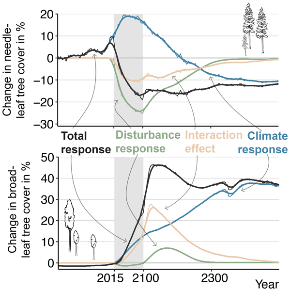
Lucia S. Layritz, Konstantin Gregor, Andreas Krause, Stefan Kruse, Benjamin F. Meyer, Thomas A. M. Pugh, and Anja Rammig
Biogeosciences, 22, 3635–3660, https://doi.org/10.5194/bg-22-3635-2025, https://doi.org/10.5194/bg-22-3635-2025, 2025
Short summary
Short summary
Disturbances, such as fire, can change which vegetation grows in a forest, affecting water and carbon flows and, thus, the climate. Disturbances are expected to increase with climate change, but it is uncertain by how much. Using a simulation model, we studied how future climate, disturbances, and their combined effect impact northern (high-latitude) forest ecosystems. Our findings highlight the importance of considering these factors and the need to better understand how disturbances will change in the future.
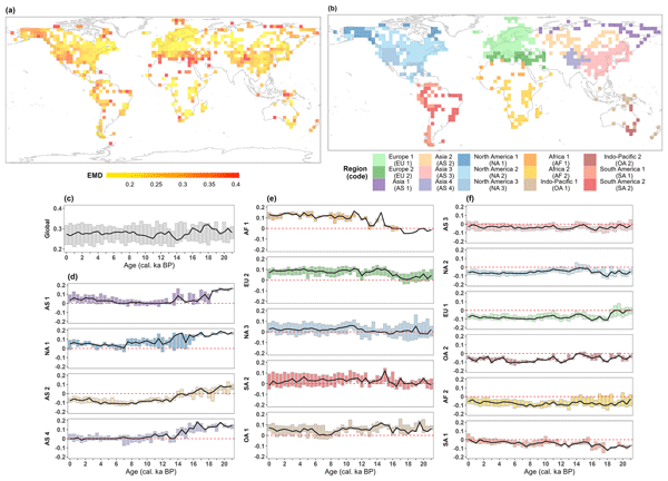
Chenzhi Li, Anne Dallmeyer, Jian Ni, Manuel Chevalier, Matteo Willeit, Andrei A. Andreev, Xianyong Cao, Laura Schild, Birgit Heim, Mareike Wieczorek, and Ulrike Herzschuh
Clim. Past, 21, 1001–1024, https://doi.org/10.5194/cp-21-1001-2025, https://doi.org/10.5194/cp-21-1001-2025, 2025
Short summary
Short summary
We present global megabiome dynamics and distributions derived from pollen-based reconstructions over the last 21 000 years, which are suitable for the evaluation of Earth-system-model-based paleo-megabiome simulations. We identified strong deviations between pollen- and model-derived megabiome distributions in the circum-Arctic and Tibetan Plateau areas during the Last Glacial Maximum and early deglaciation and in northern Africa and the Mediterranean region during the Holocene.
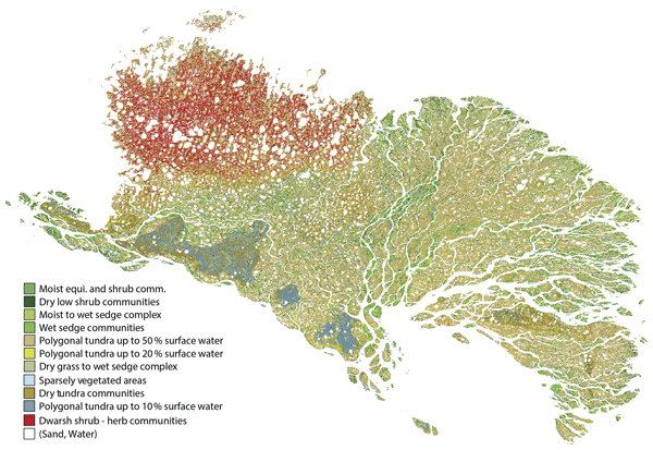
Simeon Lisovski, Alexandra Runge, Iuliia Shevtsova, Nele Landgraf, Anne Morgenstern, Ronald Reagan Okoth, Matthias Fuchs, Nikolay Lashchinskiy, Carl Stadie, Alison Beamish, Ulrike Herzschuh, Guido Grosse, and Birgit Heim
Earth Syst. Sci. Data, 17, 1707–1730, https://doi.org/10.5194/essd-17-1707-2025, https://doi.org/10.5194/essd-17-1707-2025, 2025
Short summary
Short summary
The Lena Delta is the largest river delta in the Arctic and represents a biodiversity hotspot. Here, we describe multiple field datasets and a detailed habitat classification map for the Lena Delta. We present context and methods of these openly available datasets and show how they can improve our understanding of the rapidly changing Arctic tundra system.
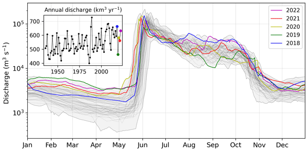
Bennet Juhls, Anne Morgenstern, Jens Hölemann, Antje Eulenburg, Birgit Heim, Frederieke Miesner, Hendrik Grotheer, Gesine Mollenhauer, Hanno Meyer, Ephraim Erkens, Felica Yara Gehde, Sofia Antonova, Sergey Chalov, Maria Tereshina, Oxana Erina, Evgeniya Fingert, Ekaterina Abramova, Tina Sanders, Liudmila Lebedeva, Nikolai Torgovkin, Georgii Maksimov, Vasily Povazhnyi, Rafael Gonçalves-Araujo, Urban Wünsch, Antonina Chetverova, Sophie Opfergelt, and Pier Paul Overduin
Earth Syst. Sci. Data, 17, 1–28, https://doi.org/10.5194/essd-17-1-2025, https://doi.org/10.5194/essd-17-1-2025, 2025
Short summary
Short summary
The Siberian Arctic is warming fast: permafrost is thawing, river chemistry is changing, and coastal ecosystems are affected. We aimed to understand changes in the Lena River, a major Arctic river flowing to the Arctic Ocean, by collecting 4.5 years of detailed water data, including temperature and carbon and nutrient contents. This dataset records current conditions and helps us to detect future changes. Explore it at https://doi.org/10.1594/PANGAEA.913197 and https://lena-monitoring.awi.de/.
Annett Bartsch, Aleksandra Efimova, Barbara Widhalm, Xaver Muri, Clemens von Baeckmann, Helena Bergstedt, Ksenia Ermokhina, Gustaf Hugelius, Birgit Heim, and Marina Leibman
Hydrol. Earth Syst. Sci., 28, 2421–2481, https://doi.org/10.5194/hess-28-2421-2024, https://doi.org/10.5194/hess-28-2421-2024, 2024
Short summary
Short summary
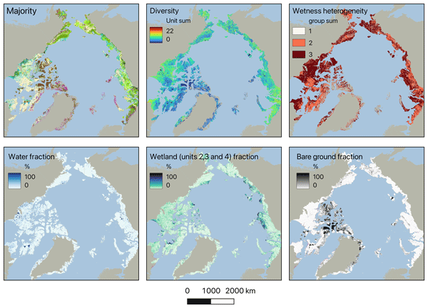
Wetness gradients and landcover diversity for the entire Arctic tundra have been assessed using a novel satellite-data-based map. Patterns of lakes, wetlands, general soil moisture conditions and vegetation physiognomy are represented at 10 m. About 40 % of the area north of the treeline falls into three units of dry types, with limited shrub growth. Wetter regions have higher landcover diversity than drier regions.
Timon Miesner, Ulrike Herzschuh, Luidmila A. Pestryakova, Mareike Wieczorek, Evgenii S. Zakharov, Alexei I. Kolmogorov, Paraskovya V. Davydova, and Stefan Kruse
Earth Syst. Sci. Data, 14, 5695–5716, https://doi.org/10.5194/essd-14-5695-2022, https://doi.org/10.5194/essd-14-5695-2022, 2022
Short summary
Short summary
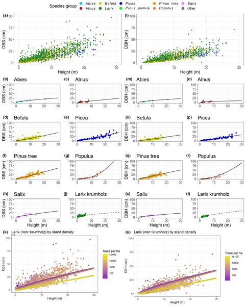
We present data which were collected on expeditions to the northeast of the Russian Federation. One table describes the 226 locations we visited during those expeditions, and the other describes 40 289 trees which we recorded at these locations. We found out that important information on the forest cannot be predicted precisely from satellites. Thus, for anyone interested in distant forests, it is important to go to there and take measurements or use data (as presented here).

Femke van Geffen, Birgit Heim, Frederic Brieger, Rongwei Geng, Iuliia A. Shevtsova, Luise Schulte, Simone M. Stuenzi, Nadine Bernhardt, Elena I. Troeva, Luidmila A. Pestryakova, Evgenii S. Zakharov, Bringfried Pflug, Ulrike Herzschuh, and Stefan Kruse
Earth Syst. Sci. Data, 14, 4967–4994, https://doi.org/10.5194/essd-14-4967-2022, https://doi.org/10.5194/essd-14-4967-2022, 2022
Short summary
Short summary
SiDroForest is an attempt to remedy data scarcity regarding vegetation data in the circumpolar region, whilst providing adjusted and labeled data for machine learning and upscaling practices. SiDroForest contains four datasets that include SfM point clouds, individually labeled trees, synthetic tree crowns and labeled Sentinel-2 patches that provide insights into the vegetation composition and forest structure of two important vegetation transition zones in Siberia, Russia.
Ulrike Herzschuh, Chenzhi Li, Thomas Böhmer, Alexander K. Postl, Birgit Heim, Andrei A. Andreev, Xianyong Cao, Mareike Wieczorek, and Jian Ni
Earth Syst. Sci. Data, 14, 3213–3227, https://doi.org/10.5194/essd-14-3213-2022, https://doi.org/10.5194/essd-14-3213-2022, 2022
Short summary
Short summary
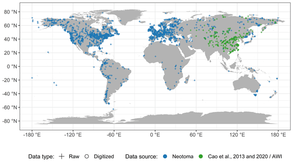
Pollen preserved in environmental archives such as lake sediments and bogs are extensively used for reconstructions of past vegetation and climate. Here we present LegacyPollen 1.0, a dataset of 2831 fossil pollen records from all over the globe that were collected from publicly available databases. We harmonized the names of the pollen taxa so that all datasets can be jointly investigated. LegacyPollen 1.0 is available as an open-access dataset.
Ramesh Glückler, Rongwei Geng, Lennart Grimm, Izabella Baisheva, Ulrike Herzschuh, Kathleen R. Stoof-Leichsenring, Stefan Kruse, Andrei Andreev, Luidmila Pestryakova, and Elisabeth Dietze
EGUsphere, https://doi.org/10.5194/egusphere-2022-395, https://doi.org/10.5194/egusphere-2022-395, 2022
Preprint archived
Short summary
Short summary
Despite rapidly intensifying wildfire seasons in Siberian boreal forests, little is known about long-term relationships between changes in vegetation and shifts in wildfire activity. Using lake sediment proxies, we reconstruct such environmental changes over the past 10,800 years in Central Yakutia. We find that a more open forest may facilitate increased amounts of vegetation burning. The present-day dense larch forest might yet be mediating the current climate-driven wildfire intensification.
Robert Jackisch, Björn H. Heincke, Robert Zimmermann, Erik V. Sørensen, Markku Pirttijärvi, Moritz Kirsch, Heikki Salmirinne, Stefanie Lode, Urpo Kuronen, and Richard Gloaguen
Solid Earth, 13, 793–825, https://doi.org/10.5194/se-13-793-2022, https://doi.org/10.5194/se-13-793-2022, 2022
Short summary
Short summary
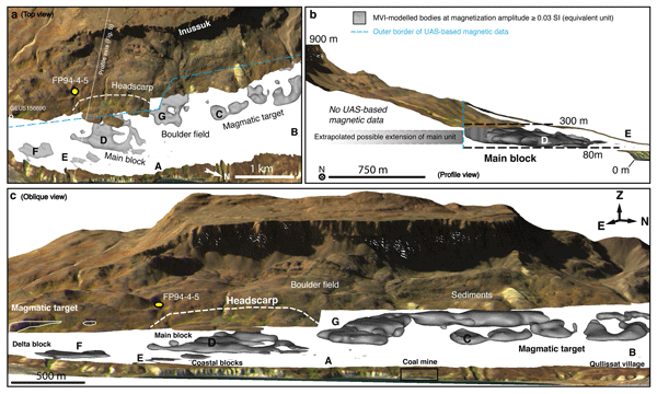
We integrate UAS-based magnetic and multispectral data with legacy exploration data of a Ni–Cu–PGE prospect on Disko Island, West Greenland. The basalt unit has a complex magnetization, and we use a constrained 3D magnetic vector inversion to estimate magnetic properties and spatial dimensions of the target unit. Our 3D modelling reveals a horizontal sheet and a strong remanent magnetization component. We highlight the advantage of UAS use in rugged and remote terrain.
Stefan Kruse, Simone M. Stuenzi, Julia Boike, Moritz Langer, Josias Gloy, and Ulrike Herzschuh
Geosci. Model Dev., 15, 2395–2422, https://doi.org/10.5194/gmd-15-2395-2022, https://doi.org/10.5194/gmd-15-2395-2022, 2022
Short summary
Short summary
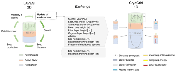
We coupled established models for boreal forest (LAVESI) and permafrost dynamics (CryoGrid) in Siberia to investigate interactions of the diverse vegetation layer with permafrost soils. Our tests showed improved active layer depth estimations and newly included species growth according to their species-specific limits. We conclude that the new model system can be applied to simulate boreal forest dynamics and transitions under global warming and disturbances, expanding our knowledge.
Cited articles
Aldaeri, A. S. T. M., Kit, C. Y., Ting, L. S., and Abdul Rahman, M. R. B.: Deep Learning for Tree Crown Detection and Delineation Using UAV and High-Resolution Imagery for Biometric Parameter Extraction: A Systematic Review, Forests, 17, https://doi.org/10.3390/f17020179, 2026. a
Al Rosyid, A. N. I., Astika, I. W., Setiawan, Y., Muttaqin, K. H., Impron, Imantho, H., Sugiarto, S. W., Endiviana, O. A., and Yuliawan, T.: Visible Band Optimation of Unmanned Aerial Vehicle for Estimating Synthetic NDVI on Rice Vegetation, J. Keteknikan Pertanian, 10, 281–290, https://doi.org/10.19028/jtep.010.3.281-290, 2022. a
Andrade, R. G., Hott, M. C., Coelho Pereira de Magalhães Junior, W., D'Oliveira, P. D., and Silva e Oliveira, J.: Monitoring of corn growth stages by UAV platform sensors, International J. Adv. Eng. Res. Sci., 6, 54–58, https://doi.org/10.22161/ijaers.69.5, 2019. a
Andreas, T., Burmeister, J.-M., Christoph, G., Tim, R., and Arne, N.: LAUTx – Individual Tree Point Clouds From Austrian Forest Inventory Plot, Zenodo [data set], https://doi.org/10.5281/zenodo.16910335, 2025. a
Atkins, J. W., Costanza, J., Dahlin, K. M., Dannenberg, M. P., Elmore, A. J., Fitzpatrick, M. C., Hakkenberg, C. R., Hardiman, B. S., Kamoske, A., LaRue, E. A., Silva, C. A., Stovall, A. E. L., and Tielens, E. K.: Scale dependency of lidar-derived forest structural diversity, Meth. Ecol. Evol., 14, 708–723, https://doi.org/10.1111/2041-210X.14040, 2023. a
Axelsson, A., Lindberg, E., and Olsson, H.: Exploring Multispectral ALS Data for Tree Species Classification, Remote Sens., 10, 183, https://doi.org/10.3390/rs10020183, 2018. a
Brieger, F., Herzschuh, U., Pestryakova, L., Bookhagen, B., Zakharov, E., and Kruse, S.: Advances in the Derivation of Northeast Siberian Forest Metrics Using High-Resolution UAV-Based Photogrammetric Point Clouds, Remote Sens., 11, 1447, https://doi.org/10.3390/rs11121447, 2019. a, b
Brunner, A. and Houtmeyers, S.: Segmentation of conifer tree crowns from terrestrial laser scanning point clouds in mixed stands of Scots pine and Norway spruce, Eur. J. Forest Res., 141, 909–925, https://doi.org/10.1007/s10342-022-01481-5, 2022. a
Burmeister, M., Tockner, A., Reder, S., Engel, M., Richter, R., Mund, J., and Döllner, J.: treeX: Unsupervised Tree Instance Segmentation in Dense Forest Point Clouds, arXiv [preprint], https://doi.org/10.48550/arXiv.2509.03633, 2025. a
Chavana-Bryant, C., Wilkes, P., Yang, W., Burt, A., Vines, P., Bennett, A. C., Pickavance, G. C., Cooper, D. L. M., Lewis, S. L., Phillips, O. L., Brede, B., Lau, A., Herold, M., McNicol, I. M., Mitchard, E. T. A., Coomes, D. A., Jackson, T. D., Makaga, L., Milamizokou Napo, H. O., Ngomanda, A., Ntie, S., Medjibe, V., Dimbonda, P., Soenens, L., Daelemans, V., Proux, L., Nilus, R., Labrière, N., Jeffery, K., Burslem, D. F. R. P., Clewley, D., Moffat, D., Qie, L., Bartholomeus, H., Vincent, G., Barbier, N., Derroire, G., Abernethy, K., Scipal, K., and Disney, M.: ForestScan: a unique multiscale dataset of tropical forest structure across 3 continents including terrestrial, UAV and airborne LiDAR and in-situ forest census data, Earth Syst. Sci. Data, 18, 1243–1274, https://doi.org/10.5194/essd-18-1243-2026, 2026. a
Chehreh, B., Moutinho, A., and Viegas, C.: Latest Trends on Tree Classification and Segmentation Using UAV Data – A Review of Agroforestry Applications, Remote Sens., 15, 2263, https://doi.org/10.3390/rs15092263, 2023. a
Crespo-Peremarch, P., Fournier, R. A., Nguyen, V.-T., van Lier, O. R., and Ángel Ruiz, L.: A comparative assessment of the vertical distribution of forest components using full-waveform airborne, discrete airborne and discrete terrestrial laser scanning data, Forest Ecol. Manag., 473, 118268, https://doi.org/10.1016/j.foreco.2020.118268, 2020. a
Dubrovin, I., Fortin, C., and Kedrov, A.: An open dataset for individual tree detection in UAV LiDAR point clouds and RGB orthophotos in dense mixed forests, Sci. Rep., 14, 21938, https://doi.org/10.1038/s41598-024-72669-5, 2024. a, b
Enguehard, L., Heim, B., Herzschuh, U., Dinkel, V., Juday, G., Panda, S., Falco, N., Schladebach, J., Broers, J., and Kruse, S.: Investigating boreal forest successional stages in Alaska and Northwest Canada using UAV-LiDAR and RGB and a community detection network, Remote Sens. Ecol. Conserv., 12, 129–147, https://doi.org/10.1002/rse2.70029, 2025. a, b, c
ESA: Land Cover CCI Product User Guide Version 2.0, Technical Report CCI-LC-PUGv2, ESA – European Space Agency, http://maps.elie.ucl.ac.be/CCI/viewer/download/ESACCI-LC-Ph2-PUGv2_2.0.pdf (last access: 23 October 2024), 2017. a
European Space Agency: Copernicus Global Digital Elevation Model, https://doi.org/10.5069/G9028PQB, 2024. a
Falkowski, M., Smith, A., Gessler, P., Hudak, A., Vierling, L., and Evans, J.: The influence of conifer forest canopy cover on the accuracy of two individual tree measurement algorithms using lidar data, Can. J. Remote Sens., 34, S338–S350, https://doi.org/10.5589/m08-055, 2008. a
Felden, J., Möller, L., Schindler, U., Huber, R., Schumacher, S., Koppe, R., Diepenbroek, M., and Glöckner, F. O.: PANGAEA – Data Publisher for Earth & Environmental Science, Sci. Data, 10, 347, https://doi.org/10.1038/s41597-023-02269-x, 2023. a
Fick, S. and Hijmans, R.: WorldClim 2: new 1 km spatial resolution climate surfaces for global land areas, Int. J. Climatol., 37, 4302–4315, 2017. a
Gitelson, A., Kaufman, Y., Stark, R., and Rundquist, D.: Novel Algorithms for Remote Estimation of Vegetation Fraction, Remote Sens. Environ. 80, 76–87, https://doi.org/10.1016/S0034-4257(01)00289-9, 2002. a, b
Hall, F. G., Bergen, K., Blair, J. B., Dubayah, R., Houghton, R., Hurtt, G., Kellndorfer, J., Lefsky, M., Ranson, J., Saatchi, S., Shugart, H., and Wickland, D.: Characterizing 3D vegetation structure from space: Mission requirements, Remote Sens. Environ., 115, 2753–2775, https://doi.org/10.1016/j.rse.2011.01.024, 2011. a
Hansen, M. C., Potapov, P. V., Moore, R., Hancher, M., Turubanova, S. A., Tyukavina, A., Thau, D., Stehman, S. V., Goetz, S. J., Loveland, T. R., Kommareddy, A., Egorov, A., Chini, L., Justice, C. O., and Townshend, J. R. G.: High-Resolution Global Maps of 21st-Century Forest Cover Change, Science, 342, 850–853, https://doi.org/10.1126/science.1244693, 2013. a
Hastings, J., Ollinger, S., Ouimette, A., Sanders-DeMott, R., Palace, M., Ducey, M., Sullivan, F., Basler, D., and Orwig, D.: Tree Species Traits Determine the Success of LiDAR-Based Crown Mapping in a Mixed Temperate Forest, Remote Sens., 12, 309, https://doi.org/10.3390/rs12020309, 2020. a
Heinzel, B.: Investigating multiple data sources for tree species classification in temperate forest and use for single tree delineation, Int. J. Appl. Earth Obs. Geoinf., 18, 101–110, https://doi.org/10.1016/j.jag.2012.01.025, 2012. a
Henrich, J., van Delden, J., Seidel, D., Kneib, T., and Ecker, A. S.: TreeLearn: A deep learning method for segmenting individual trees from ground-based LiDAR forest point clouds, Ecol. Inform., 84, 102888, https://doi.org/10.1016/j.ecoinf.2024.102888, 2024. a, b
Ho, Y.-F., Hengl, T., and Parente, L.: Ensemble Digital Terrain Model (EDTM) of the world (1.1), Zenodo [data set], https://doi.org/10.5281/zenodo.7676373, 2023. a
Irwin, L., Coops, N., Riofrío, J., Grubinger, S., Barbeito, I., Achim, A., and Roeser, D.: Prioritizing commercial thinning: quantification of growth and competition with high-density drone laser scanning, Forestry, 98, 293–307, https://doi.org/10.1093/forestry/cpae030, 2024. a, b
Isenburg, M.: LAStools – efficient tools for LiDAR processing, version 230914, http://lastools.org (last access: 10 June 2023), 2023. a
Iusem, A. N. and Seeger, A.: Axiomatization of the Index of Pointedness for Closed Convex Cones, Comput. Appl. Math., 24, 245–283, https://doi.org/10.1590/S0101-82052005000200006, 2005. a
Ivanov, A., Darman, G., and Solovyov, I.: Species Diversity in Larch Forests of Amur Oblast and the Republic of Sakha (Yakutia), Contemp. Problems Ecol., 16, 964–971, https://doi.org/10.1134/S1995425523070041, 2023. a
Jaafar, W., Nelson, R. F., Zolkos, S., Russell, M., Lindsell, J., Abu Salim, K., and Dubayah, R.: Improving individual tree crown delineation and attributes estimation of tropical forests using airborne LiDAR data, Remote Sens., 10, 854, https://doi.org/10.3390/rs10060854, 2018. a, b
Jafarigol, E. and Trafalis, T.: A Review of Machine Learning Techniques in Imbalanced Data and Future Trends, arXiv [preprint], https://doi.org/10.48550/arXiv.2310.07917, 2023. a
Kauppi, P.: Large Impacts of Climatic Warming on Growth of Boreal Forests since 1960, PLOS ONE, 9, 1–6, https://doi.org/10.1371/journal.pone.0111340, 2014. a
Kohavi, R.: A study of cross-validation and bootstrap for accuracy estimation and model selection, in: Proceedings of the 14th International Joint Conference on Artificial Intelligence – Volume 2, IJCAI'95, Morgan Kaufmann Publishers Inc., San Francisco, CA, USA, 1137–1143, ISBN 1558603638, 1995. a
Korpela, I., Polvivaara, A., Papunen, S., Jaakkola, L., Tienaho, N., Uotila, J., Puputti, T., and Flyktman, A.: Airborne dual-wavelength waveform LiDAR improves species classification accuracy of boreal broadleaved and coniferous trees, Silva Fennica, 56, 22007, https://doi.org/10.14214/sf.22007, 2023. a
Kruse, S., Haupt, S., and Farkas, L.: Full panorama images of 33 field plot centres during the expedition to Northwest Canada, summer 2022, PANGAEA [data set], https://doi.org/10.1594/PANGAEA.974472, 2025a. a
Kruse, S., Jackisch, R., Gloy, J., Farkas, L., Schladebach, J., Hao, K., Heim, B., Kolmogorov, A., Zakharov, E. S., Pestryakova, L. A., Förster, M., Kleinschmit, B., and Herzschuh, U.: Point clouds with ground point classification and individual tree segmentation of 89 northern boreal forest and tundra sites from UAV-based lidar surveys in Yakutia, Russia in 2021, PANGAEA [data set], https://doi.org/10.1594/PANGAEA.980735, 2025b. a, b, c, d, e
Kruse, S., Gloy, J., Farkas, L., Schladebach, J., Hao, K., Döpper, V., and Heim, B.: Point clouds with ground point classification and individual tree segmentation of 25 northern boreal forest and tundra sites from UAV-based lidar surveys in northwestern Canada in 2022, PANGAEA [data set], https://doi.org/10.1594/PANGAEA.977771, 2025c. a, b, c, d, e
Kruse, S., Enguehard, L., Juday, G., Santosh, P., Badola, A., Broers, J., Farkas, L., Schladebach, J., Hao, K., Jackisch, R., Döpper, V., and Heim, B.: Point clouds with ground point classification and individual tree segmentation of 47 northern boreal forest and tundra sites from UAV-based lidar surveys in the eastern part of Alaska in 2023, PANGAEA [data set], https://doi.org/10.1594/PANGAEA.980485, 2025d. a, b, c, d, e
Kruse, S., Enguehard, L., Juday, G., Santosh, P., Badola, A., Broers, J., Farkas, L., Schladebach, J., Hao, K., Jackisch, R., Döpper, V., and Heim, B.: Point clouds with ground point classification and individual tree segmentation of 28 northern boreal forest and tundra sites from UAV-based lidar surveys in western and central parts of Alaska in 2024, PANGAEA [data set], https://doi.org/10.1594/PANGAEA.980757, 2025e. a, b, c, d, e
Kruse, S., Schladebach, J., Broers, J., Hao, K., Tretton, J., and Gorshunova, A.: Reference dataset of individual trees from the Tundra-Taiga-Ecotone and Northern boreal forests BorFIT, PANGAEA [data set], https://doi.org/10.1594/PANGAEA.980505, 2026. a, b, c, d
Kuhn, M.: Building Predictive Models in R Using the caret Package, J. Stat. Softw., 28, 1–26, https://doi.org/10.18637/jss.v028.i05, 2008. a, b
Liu, Y., You, H., Tang, X., You, Q., Huang, Y., and Chen, J.: Study on Individual Tree Segmentation of Different Tree Species Using Different Segmentation Algorithms Based on 3D UAV Data, Forests, 14, https://doi.org/10.3390/f14071327, 2023. a
Ma, K., Chen, Z., Fu, L., Tian, W., Jiang, F., Yi, J., Du, Z., and Sun, H.: Performance and Sensitivity of Individual Tree Segmentation Methods for UAV-LiDAR in Multiple Forest Types, Remote Sens., 14, 298, https://doi.org/10.3390/rs14020298, 2022. a
Michałowska, M. and Rapiński, J.: A Review of Tree Species Classification Based on Airborne LiDAR Data and Applied Classifiers, Remote Sens., 13, 353, https://doi.org/10.3390/rs13030353, 2021. a, b, c, d
Morgenstern, A., Heim, B., Pestryakova, L. A., Bolshiyanov, D. Y., Grigoriev, M. N., Ayunov, D., Dill, A., and Jünger, I.: Russian-German Cooperation: Expeditions to Siberia in 2021, in: vol. 772 of Berichte zur Polar- und Meeresforschung = Reports on polar and marine research, Alfred-Wegener-Institut Helmholtz-Zentrum für Polar- und Meeresforschung, https://doi.org/10.57738/BzPM_0772_2023, 2023. a
Myneni, R., Keeling, C., Tucker, C., Asrar, G., and Nemani, R.: Increased plant growth in the northern high latitudes from 1981 to 1991, Nature, 386, 698–702, https://doi.org/10.1038/386698a0, 1997. a
Pan, Y., Birdsey, R., Phillips, O., and Jackson, R.: The Structure Distribution and Biomass of the World's Forests, Annu. Rev. Ecol. Evol. System., 44, 593–622, https://doi.org/10.1146/annurev-ecolsys-110512-135914, 2013. a
Persson A., H. J.: Identifying species of individual trees using airborne laser scanner, Remote Sens. Environ., 90, 415–423, https://doi.org/10.1016/S0034-4257(03)00140-8, 2004. a
Puliti, S., Pearse, G., Surový, P., Wallace, L., Hollaus, M., Wielgosz, M., and Astrup, R.: FOR-instance: a UAV laser scanning benchmark dataset for semantic and instance segmentation of individual trees, arXiv [preprint], https://doi.org/10.48550/arXiv.2309.01279, 2023. a, b, c
Puliti, S., Lines, E. R., Múllerová, J., Frey, J., Schindler, Z., Straker, A., Allen, M. J., Winiwarter, L., Rehush, N., Hristova, H., Murray, B., Calders, K., Coops, N., Höfle, B., Irwin, L., Junttila, S., Krůček, M., Krok, G., Král, K., Levick, S. R., Luck, L., Missarov, A., Mokroš, M., Owen, H. J. F., Stereńczak, K., Pitkänen, T. P., Puletti, N., Saarinen, N., Hopkinson, C., Terryn, L., Torresan, C., Tomelleri, E., Weiser, H., and Astrup, R.: Benchmarking tree species classification from proximally sensed laser scanning data: Introducing the FOR-species20K dataset, Meth. Ecol. Evol., 16, 801–818, https://doi.org/10.1111/2041-210X.14503, 2025. a, b, c
Qian, C., Yao, C., Ma, H., Xu, J., and Wang, J.: Tree Species Classification Using Airborne LiDAR Data Based on Individual Tree Segmentation and Shape Fitting, Remote Sens., 15, 406, https://doi.org/10.3390/rs15020406, 2023. a, b, c, d
Ranson, K., Montesano, P., and Nelson, R.: Tree Canopy Cover for the Circumpolar Taiga-Tundra Ecotone: 2000–2005, ORNL DAAC [data set], https://doi.org/10.3334/ORNLDAAC/1218, 2014. a
Roland, C., Schmidt, J., and Nicklen, E.: Landscape-scale patterns in tree occupancy and abundance in subarctic Alaska, Ecol. Monogr., 83, 19–48, https://doi.org/10.1890/11-2136.1, 2013. a
Scheffer, M., Hirota, M., Holmgren, M., Nes, E. H. V., and Chapin, F. S.: Thresholds for boreal biome transitions, P. Natl. Acda. Sci. USA, 109, 21384–21389, https://doi.org/10.1073/pnas.1219844110, 2012. a
Schladebach, J.: BorFIT, GitHub [code], https://github.com/StefanKruse/BorFIT/tree/main (last access: 27 October 2026), 2026. a
Schulte, L., Meucci, S., Stoof-Leichsenring, K., Heitkam, T., Schmidt, N., von Hippel, B., Andreev, A., Diekmann, B., Melles, M., Pestryakova, L., Alsos, I., Clarke, C., Krutovsky, K., and Herzschuh, U.: Larix species range dynamics in Siberia since the Last Glacial captured from sedimentary ancient DNA, Commun. Biol., 5, 570, https://doi.org/10.1038/s42003-022-03455-0, 2022. a
Shcherbacheva, A., Campos, M. B., Wang, Y., Liang, X., Kukko, A., Hyyppä, J., Junttila, S., Lintunen, A., Korpela, I., and Puttonen, E.: A study of annual tree-wise LiDAR intensity patterns of boreal species observed using a hyper-temporal laser scanning time series, Remote Sens. Environ., 305, 114083, https://doi.org/10.1016/j.rse.2024.114083, 2024. a
Shi, Y., Skidmore, A., Wang, T., Holzwarth, S., Heiden, U., Pinnel, N., Zhu, X., and Heurich, M.: Tree species classification using plant functional traits from LiDAR and hyperspectral data, Int. J. Appl. Earth Obs. Geoinf., 73, 207–219, https://doi.org/10.1016/j.jag.2018.06.018, 2018. a, b
Thiffault, E.: Boreal forests and soils, in: vol. 36 of Developments in Soil Science, Elsevier, https://doi.org/10.1016/B978-0-444-63998-1.00005-7, 2019. a
Tong, F. and Zhang, Y.: Individual tree crown delineation in high resolution aerial RGB imagery using StarDist-based model, Remote Sens. Environ., 319, 114618, https://doi.org/10.1016/j.rse.2025.114618, 2025. a
Tucker, C. J.: Red and Photographic Infrared Linear Combinations for Monitoring Vegetation, Remote Sens. Environ., 8, 127–150, https://doi.org/10.1016/0034-4257(79)90013-0, 1979. a, b
van Geffen, F., Heim, B., Brieger, F., Geng, R., Shevtsova, I. A., Schulte, L., Stuenzi, S. M., Bernhardt, N., Troeva, E. I., Pestryakova, L. A., Zakharov, E. S., Pflug, B., Herzschuh, U., and Kruse, S.: SiDroForest: a comprehensive forest inventory of Siberian boreal forest investigations including drone-based point clouds individually labeled trees synthetically generated tree crowns and Sentinel-2 labeled image patches, Earth Syst. Sci. Data, 14, 4967–4994, https://doi.org/10.5194/essd-14-4967-2022, 2022. a, b
Vauhkonen, J., Tokola, T., Packalén, P., and Maltamo, M.: Identification of Scandinavian Commercial Species of Individual Trees from Airborne Laser Scanning Data Using Alpha Shape Metrics, Forest Sci., 55, 37–47, https://doi.org/10.1093/forestscience/55.1.37, 2009. a
Walker, D. A., Raynolds, M. K., Daniëls, F. J., Einarsson, E., Elvebakk, A., Gould, W. A., Katenin, A. E., Kholod, S. S., Markon, C. J., Melnikov, E. S., Moskalenko, N. G., Talbot, S. S., and Yurtsev, B. A.: The Circumpolar Arctic vegetation map, J. Veg. Sci., 16, 267–282, https://doi.org/10.1111/j.1654-1103.2005.tb02365.x, 2005. a
Weiser, H., Schäfer, J., Winiwarter, L., Krašovec, N., Fassnacht, F. E., and Höfle, B.: Individual tree point clouds and tree measurements from multi-platform laser scanning in German forests, Earth Syst. Sci. Data, 14, 2989–3012, https://doi.org/10.5194/essd-14-2989-2022, 2022. a, b
Wittke, S., Campos, M., Ruoppa, L., Echriti, R., Wang, Y., Golos, A., Kukko, A., Hyyppä, J., and Puttonen, E.: LiPheStream – A18-month high spatiotemporal resolution point cloud time series of Boreal trees from Finland, Sci. Data, 11, 1281, https://doi.org/10.1038/s41597-024-04143-w, 2024. a, b
Xi, Y., Zhang, W., Wei, F., Fang, Z., and Fensholt, R.: Boreal tree species diversity increases with global warming but is reversed by extremes, Nat. Plants, 10, 1473–1483, 2024. a
Xiang, B., Wielgosz, M., Kontogianni, T., Peters, T., Puliti, S., Astrup, R., and Schindler, K.: Automated forest inventory: Analysis of high-density airborne LiDAR point clouds with 3D deep learning, Remote Sens. Environ., 305, 114078, https://doi.org/10.1016/j.rse.2024.114078, 2024. a
You, H., Lei, P., Li, M., and Ruan, F.: Forest species classification based on three-dimensional coordinate and intensity information of airborne LiDAR data with random forest method, Int. Arch. Photogram. Remote Sens. Spat. Inf. Sci., XLII-3/W10, 117–123, https://doi.org/10.5194/isprs-archives-XLII-3-W10-117-2020, 2020. a
Zhao, F., Popescu, S., and Meng, X.: Characterizing forest canopy structure with lidar data: Applications to forest management and ecosystem studies, Remote Sens. Environ., 115, 1237–1252, https://doi.org/10.1016/j.rse.2011.04.001, 2011. a
Short summary
BorFIT is a novel training dataset for light detection and ranging (LiDAR) point cloud segmentation and tree species detection in boreal forests. Comprising 384 plots across Siberia, Canada, and Alaska, it features 16 530 manually segmented trees of 12 species. BorFIT supports artificial intelligence (AI) applications for analyzing species distribution, stand structure, and boreal forest response to climate change.
BorFIT is a novel training dataset for light detection and ranging (LiDAR) point cloud...


Altmetrics
Final-revised paper
Preprint