Articles | Volume 18, issue 10
https://doi.org/10.5194/essd-18-7391-2026
© Author(s) 2026. This work is distributed under
the Creative Commons Attribution 4.0 License.
https://doi.org/10.5194/essd-18-7391-2026
© Author(s) 2026. This work is distributed under
the Creative Commons Attribution 4.0 License.
WAPOSAL: a multi-regional wave dataset from satellite altimetry for significant wave height, period estimation, and wave power density

Sonia Ponce de León
Centre for Marine Technology and Ocean Engineering (CENTEC), Instituto Superior Técnico, Universidade de Lisboa, Lisbon, Portugal
Institute of Marine Science (ICM), Spanish Research Council (CSIC), Institut Català de Recerca per a la Governança del Mar (ICATMAR), Barcelona, Spain
Maria Panfilova
CORRESPONDING AUTHOR
Centre for Marine Technology and Ocean Engineering (CENTEC), Instituto Superior Técnico, Universidade de Lisboa, Lisbon, Portugal
Andrés F. Orejarena-Rondón
Centre for Marine Technology and Ocean Engineering (CENTEC), Instituto Superior Técnico, Universidade de Lisboa, Lisbon, Portugal
LOGER, Escuela Naval de Cadetes “Almirante Padilla”, Cartagena de Indias, Colombia
Marco Restano
ATG-Europe c/o ESA-ESRIN, Frascati, Italy
Roberto Sabia
ESA-ESRIN, Frascati, Italy
Jérôme Benveniste
COSPAR, Paris, France
Related authors
No articles found.
Verónica González-Gambau, Estrella Olmedo, Aina García-Espriu, Cristina González-Haro, Antonio Turiel, Carolina Gabarró, Alessandro Silvano, Aditya Narayanan, Alberto Naveira-Garabato, Rafael Catany, Nina Hoareau, Marta Umbert, Giuseppe Aulicino, Yuri Cotroneo, Roberto Sabia, and Diego Fernández-Prieto
Earth Syst. Sci. Data, 17, 5089–5111, https://doi.org/10.5194/essd-17-5089-2025, https://doi.org/10.5194/essd-17-5089-2025, 2025
Short summary
Short summary
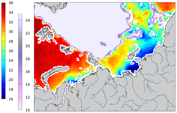
This paper introduces a new Sea Surface Salinity product for the Southern Ocean, based on SMOS data and developed by the Barcelona Expert Center. It offers 9 d maps on a 25 km EASE-SL grid, from 2011 to 2023, covering areas south of 30° S. The product is accurate beyond 150 km from sea ice, with nearly zero bias and a ~0.22 STD. It tracks well seasonal and interannual changes and will contribute to the understanding of processes influenced by upper-ocean salinity, including ice formation/melt.
Jérôme Benveniste, Salvatore Dinardo, Luciana Fenoglio-Marc, Christopher Buchhaupt, Michele Scagliola, Marcello Passaro, Karina Nielsen, Marco Restano, Américo Ambrózio, Giovanni Sabatino, Carla Orrù, and Beniamino Abis
Proc. IAHS, 385, 457–463, https://doi.org/10.5194/piahs-385-457-2024, https://doi.org/10.5194/piahs-385-457-2024, 2024
Short summary
Short summary
This paper presents the RDSAR, SAR/SARin & FF-SAR altimetry processors available in the ESA Altimetry Virtual Lab (AVL) hosted on the EarthConsole® platform. An overview on processors and features as well as preliminary analyses using AVL output data are reported to demonstrate the quality of the ESA Altimetry Virtual Lab altimetry services in providing innovative solutions to the radar altimetry community. https://earthconsole.eu//
Victor Rousseau, Robin Fraudeau, Matthew Hammond, Odilon Joël Houndegnonto, Michaël Ablain, Alejandro Blazquez, Fransisco Mir Calafat, Damien Desbruyères, Giuseppe Foti, William Llovel, Florence Marti, Benoît Meyssignac, Marco Restano, and Jérôme Benveniste
Earth Syst. Sci. Data Discuss., https://doi.org/10.5194/essd-2023-236, https://doi.org/10.5194/essd-2023-236, 2023
Preprint withdrawn
Short summary
Short summary
The estimation of regional Ocean Heat Content (OHC) is crucial for climate analysis and future climate predictions. In our study, we accurately estimate regional OHC changes in the Atlantic Ocean using satellite and in situ data. Findings reveal significant warming in the Atlantic basin from 2002 to 2020 with a mean trend of 0.17W/m², representing 230 times the power of global nuclear plants. The product has also been successfully validated in the North Atlantic basin using in situ data.
Stefania Camici, Gabriele Giuliani, Luca Brocca, Christian Massari, Angelica Tarpanelli, Hassan Hashemi Farahani, Nico Sneeuw, Marco Restano, and Jérôme Benveniste
Geosci. Model Dev., 15, 6935–6956, https://doi.org/10.5194/gmd-15-6935-2022, https://doi.org/10.5194/gmd-15-6935-2022, 2022
Short summary
Short summary
This paper presents an innovative approach, STREAM (SaTellite-based Runoff Evaluation And Mapping), to derive daily river discharge and runoff estimates from satellite observations of soil moisture, precipitation, and terrestrial total water storage anomalies. Potentially useful for multiple operational and scientific applications, the added value of the STREAM approach is the ability to increase knowledge on the natural processes, human activities, and their interactions on the land.
Verónica González-Gambau, Estrella Olmedo, Antonio Turiel, Cristina González-Haro, Aina García-Espriu, Justino Martínez, Pekka Alenius, Laura Tuomi, Rafael Catany, Manuel Arias, Carolina Gabarró, Nina Hoareau, Marta Umbert, Roberto Sabia, and Diego Fernández
Earth Syst. Sci. Data, 14, 2343–2368, https://doi.org/10.5194/essd-14-2343-2022, https://doi.org/10.5194/essd-14-2343-2022, 2022
Short summary
Short summary
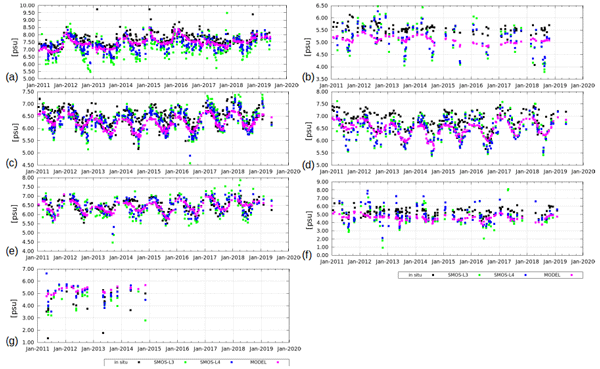
We present the first Soil Moisture and Ocean Salinity Sea Surface Salinity (SSS) dedicated products over the Baltic Sea (ESA Baltic+ Salinity Dynamics). The Baltic+ L3 product covers 9 days in a 0.25° grid. The Baltic+ L4 is derived by merging L3 SSS with sea surface temperature information, giving a daily product in a 0.05° grid. The accuracy of L3 is 0.7–0.8 and 0.4 psu for the L4. Baltic+ products have shown to be useful, covering spatiotemporal data gaps and for validating numerical models.
Martin Horwath, Benjamin D. Gutknecht, Anny Cazenave, Hindumathi Kulaiappan Palanisamy, Florence Marti, Ben Marzeion, Frank Paul, Raymond Le Bris, Anna E. Hogg, Inès Otosaka, Andrew Shepherd, Petra Döll, Denise Cáceres, Hannes Müller Schmied, Johnny A. Johannessen, Jan Even Øie Nilsen, Roshin P. Raj, René Forsberg, Louise Sandberg Sørensen, Valentina R. Barletta, Sebastian B. Simonsen, Per Knudsen, Ole Baltazar Andersen, Heidi Ranndal, Stine K. Rose, Christopher J. Merchant, Claire R. Macintosh, Karina von Schuckmann, Kristin Novotny, Andreas Groh, Marco Restano, and Jérôme Benveniste
Earth Syst. Sci. Data, 14, 411–447, https://doi.org/10.5194/essd-14-411-2022, https://doi.org/10.5194/essd-14-411-2022, 2022
Short summary
Short summary
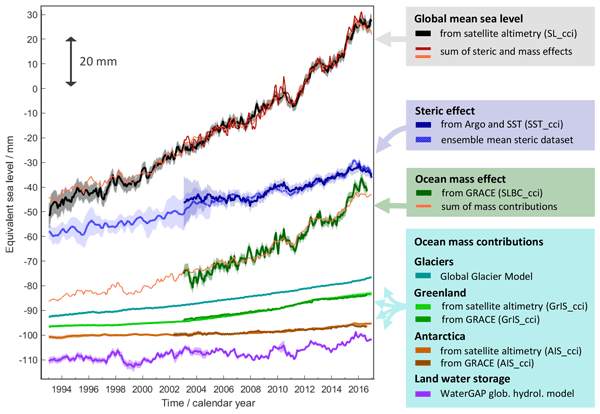
Global mean sea-level change observed from 1993 to 2016 (mean rate of 3.05 mm yr−1) matches the combined effect of changes in water density (thermal expansion) and ocean mass. Ocean-mass change has been assessed through the contributions from glaciers, ice sheets, and land water storage or directly from satellite data since 2003. Our budget assessments of linear trends and monthly anomalies utilise new datasets and uncertainty characterisations developed within ESA's Climate Change Initiative.
Justino Martínez, Carolina Gabarró, Antonio Turiel, Verónica González-Gambau, Marta Umbert, Nina Hoareau, Cristina González-Haro, Estrella Olmedo, Manuel Arias, Rafael Catany, Laurent Bertino, Roshin P. Raj, Jiping Xie, Roberto Sabia, and Diego Fernández
Earth Syst. Sci. Data, 14, 307–323, https://doi.org/10.5194/essd-14-307-2022, https://doi.org/10.5194/essd-14-307-2022, 2022
Short summary
Short summary
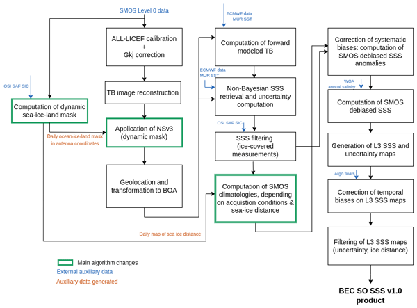
Measuring salinity from space is challenging since the sensitivity of the brightness temperature to sea surface salinity is low, but the retrieval of SSS in cold waters is even more challenging. In 2019, the ESA launched a specific initiative called Arctic+Salinity to produce an enhanced Arctic SSS product with better quality and resolution than the available products. This paper presents the methodologies used to produce the new enhanced Arctic SMOS SSS product.
Florence Marti, Alejandro Blazquez, Benoit Meyssignac, Michaël Ablain, Anne Barnoud, Robin Fraudeau, Rémi Jugier, Jonathan Chenal, Gilles Larnicol, Julia Pfeffer, Marco Restano, and Jérôme Benveniste
Earth Syst. Sci. Data, 14, 229–249, https://doi.org/10.5194/essd-14-229-2022, https://doi.org/10.5194/essd-14-229-2022, 2022
Short summary
Short summary
The Earth energy imbalance at the top of the atmosphere due to the increase in greenhouse gases and aerosol concentrations is responsible for the accumulation of energy in the climate system. With its high thermal inertia, the ocean accumulates most of this energy excess in the form of heat. The estimation of the global ocean heat content through space geodetic observations allows monitoring of the energy imbalance with realistic uncertainties to better understand the Earth’s warming climate.
Wouter Dorigo, Irene Himmelbauer, Daniel Aberer, Lukas Schremmer, Ivana Petrakovic, Luca Zappa, Wolfgang Preimesberger, Angelika Xaver, Frank Annor, Jonas Ardö, Dennis Baldocchi, Marco Bitelli, Günter Blöschl, Heye Bogena, Luca Brocca, Jean-Christophe Calvet, J. Julio Camarero, Giorgio Capello, Minha Choi, Michael C. Cosh, Nick van de Giesen, Istvan Hajdu, Jaakko Ikonen, Karsten H. Jensen, Kasturi Devi Kanniah, Ileen de Kat, Gottfried Kirchengast, Pankaj Kumar Rai, Jenni Kyrouac, Kristine Larson, Suxia Liu, Alexander Loew, Mahta Moghaddam, José Martínez Fernández, Cristian Mattar Bader, Renato Morbidelli, Jan P. Musial, Elise Osenga, Michael A. Palecki, Thierry Pellarin, George P. Petropoulos, Isabella Pfeil, Jarrett Powers, Alan Robock, Christoph Rüdiger, Udo Rummel, Michael Strobel, Zhongbo Su, Ryan Sullivan, Torbern Tagesson, Andrej Varlagin, Mariette Vreugdenhil, Jeffrey Walker, Jun Wen, Fred Wenger, Jean Pierre Wigneron, Mel Woods, Kun Yang, Yijian Zeng, Xiang Zhang, Marek Zreda, Stephan Dietrich, Alexander Gruber, Peter van Oevelen, Wolfgang Wagner, Klaus Scipal, Matthias Drusch, and Roberto Sabia
Hydrol. Earth Syst. Sci., 25, 5749–5804, https://doi.org/10.5194/hess-25-5749-2021, https://doi.org/10.5194/hess-25-5749-2021, 2021
Short summary
Short summary
The International Soil Moisture Network (ISMN) is a community-based open-access data portal for soil water measurements taken at the ground and is accessible at https://ismn.earth. Over 1000 scientific publications and thousands of users have made use of the ISMN. The scope of this paper is to inform readers about the data and functionality of the ISMN and to provide a review of the scientific progress facilitated through the ISMN with the scope to shape future research and operations.
Cited articles
Anusree, A. and Kumar, V. S.: Mean wave direction and wave height in the ERA5 reanalysis dataset: Comparison with measured data in the coastal waters of India, Dynam. Atmos. Oceans, 107, 101478, https://doi.org/10.1016/j.dynatmoce.2024.101478, 2024. a
Besio, G., Mentaschi, L., and Mazzino, A.: Wave energy resource assessment in the Mediterranean Sea on the basis of a 35-year hindcast, Energy, 94, 50–63, https://doi.org/10.1016/j.energy.2015.10.044, 2016. a
Bessonova, V., Tapoglou, E., Dorrell, R., Dethlefs, N., and York, K.: Global evaluation of wave data reanalysis: Comparison of the ERA5 dataset to buoy observations, Appl. Ocean Res., 157, 104490, https://doi.org/10.1016/j.apor.2025.104490, 2025. a
Booij, N., Ris, R. C., and Holthuijsen, L. H.: A third-generation wave model for coastal regions: SWAN, J. Geophys. Res.-Oceans, 104, 7649–7666, https://doi.org/10.1029/98JC02622, 1999. a
Cahill, B. and Lewis, T.: Wave period ratios and the calculation of wave power, in: Proceedings of the 2nd Marine Energy Technology Symposium (METS2014), Seattle, WA, USA, 15–18 April 2014, Ocean Renewable Energy Coalition, Gaithersburg, MD, USA, 10 pp., http://hdl.handle.net/10919/49206 (last access: 19 September 2026), 2014. a, b
Dinardo, S., Fenoglio-Marc, L., Buchhaupt, C., Becker, M., Scharroo, R., Fernandes, M. J., and Benveniste, J.: Coastal SAR and PLRM altimetry in German Bight and West Baltic Sea, Adv. Space Res., 62, 1371–1404, https://doi.org/10.1016/j.asr.2017.12.018, 2018. a, b
Dong, C., Huang, G., Cheng, G., Cai, Y., and Chen, C.: Macroscale altimetry-based estimation and analyses of wave power: A foundation of wave energy development over Canada, Renew. Sust. Energ. Rev., 183, 113469, https://doi.org/10.1016/j.rser.2023.113469, 2023. a
Dunnett, D. and Wallace, J. S.: Electricity generation from wave power in Canada, Renew. Energ., 34, 179–195, https://doi.org/10.1016/j.renene.2008.04.034, 2009. a
Fanti, V., Ferreira, Ó., Kümmerer, V., and Loureiro, C.: Improved estimates of extreme wave conditions in coastal areas from calibrated global reanalyses, Communications Earth & Environment, 4, 151, https://doi.org/10.1038/s43247-023-00819-0, 2023. a, b
Görmüş, T., Aydoğan, B., and Ayat, B.: Analysis of hybrid exploitation of wind and wave power in the Mediterranean and the Black Sea, Energ. Convers. Manage., 299, 117820, https://doi.org/10.1016/j.enconman.2023.117820, 2024. a
Gu, H., Chen, Y., and Yang, B.: A spherical triboelectric nanogenerator for omnidirectional wave energy harvesting utilizing gravity, J. Phys. Conf. Ser., 2932, 012038, https://doi.org/10.1088/1742-6596/2932/1/012038, 2025. a
Kasiulis, E., Punys, P., and Kofoed, J. P.: Assessment of theoretical near-shore wave power potential along the Lithuanian coast of the Baltic Sea, Renew. Sust. Energ. Rev., 41, 134–142, https://doi.org/10.1016/j.rser.2014.08.044, 2015. a
O’Connell, R., Kamidelivand, M., Furlong, R., Guerrini, M., Cullinane, M., and Murphy, J.: An advanced geospatial assessment of the levelised cost of energy (LCOE) for wave farms in Irish and western UK waters, Renew. Energ., 221, 119864, https://doi.org/10.1016/j.renene.2023.119864, 2024. a
Orejarena-Rondón, A. F., Panfilova, M., Ponce de León, S., Restano, M., Sabia, R., and Benveniste, J.: High-resolution mapping of wave energy resources in the Mediterranean Sea using satellite altimetry, Energy Reports, 15, 109133, https://doi.org/10.1016/j.egyr.2026.109133, 2026. a, b, c
Orlov, A. V.: Transition to a green economy through the development of renewable energy in the European Union, WSEAS Trans. Environ. Dev., 20, 1072–1084, https://doi.org/10.37394/232015.2024.20.98, 2024. a
Ponce de León, S., Restano, M., and Benveniste, J.: Assessment of wave power density using Sea State Climate Change Initiative database in the French façade, Journal of Marine Science and Engineering, 11, 1970, https://doi.org/10.3390/jmse11101970, 2023. a
Ponce de León, S., Restano, M., and Benveniste, J.: Assessing the wave power density in the Atlantic French façade from high-resolution CryoSat-2 SAR altimetry data, Energy, 302, 131712, https://doi.org/10.1016/j.energy.2024.131712, 2024a. a
Ponce de León, S., Bettencourt, J. H., Ringwood, J. V., and Benveniste, J.: Assessment of combined wind and wave energy in European coastal waters using satellite altimetry, Appl. Ocean Res., 2024, https://doi.org/10.1016/j.apor.2024.104184, 2024b. a
Ponce de León, S., Panfilova, M., and Orejarena-Rondón, A.: High-resolution WAPOSAL wave period and wave power density from Sentinel-3A/B, CryoSat-2, and SAMOSA+ retracker, European Space Agency [data set], https://doi.org/10.57780/ESA-1AB8CF3, 2026. a, b, c
Tolman, H. L.: User manual and system documentation of WAVEWATCH III version 3.14, NOAA/NWS/NCEP/MMAB Technical Note 276, 194 pp., https://polar.ncep.noaa.gov/mmab/papers/tn276/MMAB_276.pdf (last access: 19 September 2026), 2009. a
Vázquez, R., Gutiérrez, C., Ponce de León, S., Nieto-Borge, J. C., Sein, D. V., and Cabos, W.: Climate change impact in offshore energy resources along the Spanish coasts based on a high-resolution regionally coupled model, Renew. Energ., 249, 123202, https://doi.org/10.1016/j.renene.2025.123202, 2025. a
Vicinanza, D., Contestabile, P., and Ferrante, V.: Wave energy potential in the north-west of Sardinia (Italy), Renew. Energ., 50, 506–521, https://doi.org/10.1016/j.renene.2012.07.015, 2013.
Vignudelli, S., Scozzari, A., Abileah, R., Gómez-Enri, J., Benveniste, J., and Cipollini, P.: Water surface elevation in coastal and inland waters using satellite radar altimetry, in: Extreme Hydroclimatic Events and Multivariate Hazards in a Changing Climate, Elsevier, 83–126, https://doi.org/10.1016/B978-0-12-814899-0.00004-3, 2019. a
WAMDI Group: The WAM model – A third-generation ocean wave prediction model, J. Phys. Oceanogr., 18, 1775–1810, https://doi.org/10.1175/1520-0485(1988)018<1775:TWMTGO>2.0.CO;2, 1988. a
Short summary
This study presents a high-resolution wave energy resource database across 11 maritime regions for the period 2011–2023. Using satellite altimetry, sea wave parameters were obtained and validated against wave buoy and ERA5 data. The results provide a geospatial database for the development of marine renewable energy technologies and sustainable coastal planning, supporting the transition toward specialized offshore engineering solutions.
This study presents a high-resolution wave energy resource database across 11 maritime regions...
Altmetrics
Final-revised paper
Preprint