the Creative Commons Attribution 4.0 License.
the Creative Commons Attribution 4.0 License.
 | 28 Oct 2026
DETECT: seismological data from multiple dense arrays deployed across the Irpinia fault system in southern Italy
Francesco Scotto di Uccio

Angelo Strollo
Matteo Picozzi
Dino Bindi
Antonio Scala
Gaetano Festa
Tony Alfredo Stabile
Erwan Gueguen
Guido Maria Adinolfi
Claudio Martino
Ortensia Amoroso
Raffaella De Matteis
Vincenzo Convertito
Daniele Spallarossa
Alessandro Caruso
Francesco Carotenuto
Simona Colombelli
Grazia De Landro
Gregory De Martino
Luca Elia
Benjamin Heit
Laura Hillmann
Antonio Giovanni Iaccarino
Mauro Palo
Karina Loviknes
Stefan Mroczek
Sahar Nazeri
Titouan Muzellec
Ferdinando Napolitano
Serena Panebianco
Raffaele Rea
Rosario Riccio
Guido Russo
Vincenzo Serlenga
Stefania Tarantino
Nicola Tragni
Thomas Zieke
Jannes Münchmeyer
Peter Makus
Alister Trabattoni
Aldo Zollo
Fabrice Cotton
We present a large seismological dataset (https://geofon.gfz.de/doi/network/ZK/2021, last access: 14 October 2026) composed of continuous recordings from 200 temporary stations (seismic network ZK, https://doi.org/10.14470/MX7576871994, Bindi et al., 2021), which operated continuously for approximately one year in the Southern Apennines (Southern Italy) as part of the DETECT experiment. The dataset is compliant with the seismological standards for the archiving of data and metadata, and with standardized tools for disseminating them, e.g., the International Federation of Digital Seismograph Networks (FDSN) web services. The data set was collected during the DETECT experiment in the Irpinia area (southern Italy), which is one of the regions with the highest seismic hazard in Italy. From August 2021 to August 2022, a constellation of 20 seismic arrays, with a total of 200 seismic stations, was installed above the fault segments responsible for the Mw 6.8, 1980 Irpinia earthquake, the strongest and most destructive seismic event in Italy in the last century. Each seismic array had a maximum aperture of ∼2 km and was composed of one broad-band sensor, one short- period sensor with 1 Hz and eight 4.5 Hz natural frequency geophones. Data and metadata were managed in accordance with the GIPP/GEOFON policy using SeisComP (Helmholtz Centre Potsdam – GFZ German Research Centre for Geosciences and GEMPA GmbH, 2008), and the final archive size is approximately 5.2 TB. In this contribution, we provide details on how to download waveform data and station metadata, as well as information on data availability and quality.
- Article
(6787 KB) - Full-text XML
-
Supplement
(368 KB) - BibTeX
- EndNote


Italy is one of the most seismically hazardous countries in Europe, with the strongest historical earthquakes all characterized by magnitudes between 6 and 7 (i.e., the 1857 Mw 7.1 Basilicata earthquake, the 1908 Mw 7.1 Messina earthquake, the 1915 Mw 7.1 Fucino earthquake, the 1930 Mw 6.7 Irpinia earthquake, the 1976 Mw 6.5 Friuli earthquake, the 1980 Mw 6.8 Irpinia earthquake, the 2009 Mw 6.3 L'Aquila earthquake, and the 2016 Mw 6.6 Norcia earthquake; CPTI15, Rovida et al., 2020, 2022). Despite their moderate magnitudes, the combination of elevated seismic hazard and high structural vulnerability places communities and infrastructure in significant danger from earthquakes.
In the context of seismic risk mitigation actions, scientists are deeply involved in improving the understanding of how seismic sequences evolve and the preparatory phase preceding major earthquakes. To this end, the characterization of the spatio-temporal distribution and source properties of microearthquakes is a means of shedding light on stress accumulation and fault weakening processes that may anticipate a large rupture (Picozzi et al., 2022a). Furthermore, microearthquakes also help to monitor changes in the medium's elastic properties (Di Luccio et al., 2010; Adil et al., 2025) and can support the management of industrial activities in the context of anthropogenic seismicity (Stabile et al., 2021). For these reasons, in recent years, temporary dense arrays have been installed to enable high-resolution seismic imaging and monitoring, and to advance understanding of the dynamics of fault zones (Ben-Zion et al., 2015; Gradon et al., 2020).
This work presents and opens to the community the dataset acquired during an innovative monitoring experiment carried out in the Irpinia fault system in the southern Apennines, Italy, named “DEnse mulTi-paramEtriC observations and 4D high resoluTion imaging”, or DETECT (Bindi et al., 2021). The DETECT target area was struck by the 23 November 1980, Mw 6.8 Irpinia earthquake (Ms 6.9, as reported by Bernard and Zollo, 1989), which occurred along NW–SE striking faults. It was characterized by three main episodes that occurred within seconds of each other, resulting in approximately 3000 fatalities and widespread damage (Bernard and Zollo, 1989). The network code assigned by the International Federation of Digital Seismograph Networks (FDSN) is ZK (https://doi.org/10.14470/MX7576871994, Bindi et al., 2021). The continuous waveform archive is stored entirely in the European Integrated Data Archive (Strollo et al., 2021) and is made available via standard FDSN-compliant web services (Bindi et al., 2021). For more information, please refer to the Data availability section.
The DETECT experiment had two main objectives: (1) investigating technological solutions to enhance seismic monitoring capabilities and (2) improving our understanding of the temporal and spatial evolution of seismicity and its relationship with crustal fluids. The experiment involved the deployment of a dense network of around 200 seismic stations along the Irpinia fault system over a period of one year. These stations were organized into seismic arrays that demonstrated a high potential for detecting and locating natural and anthropogenic seismic sources (Rost and Thomas, 2009; Picozzi et al., 2011). Consequently, the DETECT dataset presented in this study can provide unique imaging and tracking of crustal fluids by lowering the detection threshold of the Irpinia Near Fault Observatory (INFO, https://www.epos-eu.org/tcs/near-fault-observatories, last access: 14 October 2026; Chiaraluce et al., 2022), which has been monitoring seismic activity in the area since 2005.
This manuscript details the technical aspects of the DETECT experiment, including network design, station deployment, and operational procedures, together with the data processing steps for format conversion and quality control. Besides sharing the waveforms collected during the one-year experiment, we also introduce and share with the community the enhanced catalog of microseismic events obtained by applying advanced detection strategies to the presented DETECT dataset (Scotto di Uccio et al., 2026). The resulting dataset holds promise for developing and testing monitoring methodologies aimed at: (1) recognizing evolving spatiotemporal trends in source parameters that may imply large-earthquake nucleation; (2) examining the frictional and stress states of fault segments in order to forecast future seismic energy release; and (3) evaluating the interactions among fault segments to better understand and potentially anticipate cascade failure mechanisms.
The tectonics of the Irpinia region is now dominated by active, extensional faults arranged in subparallel structures, mainly disseminated over the Apennines axial sector, with trends mainly ranging from WNW–ESE to NW–SE (Adinolfi et al., 2019; Bello et al., 2021). Since 2005, the Irpinia Near Fault Observatory (INFO) has been monitoring seismic activity in the area. INFO includes the Irpinia Seismic Network (ISNet; https://isnet.unina.it, last access: 14 October 2026; Iannaccone et al., 2010), which comprises 31 seismic stations (black triangles in Fig. 1).
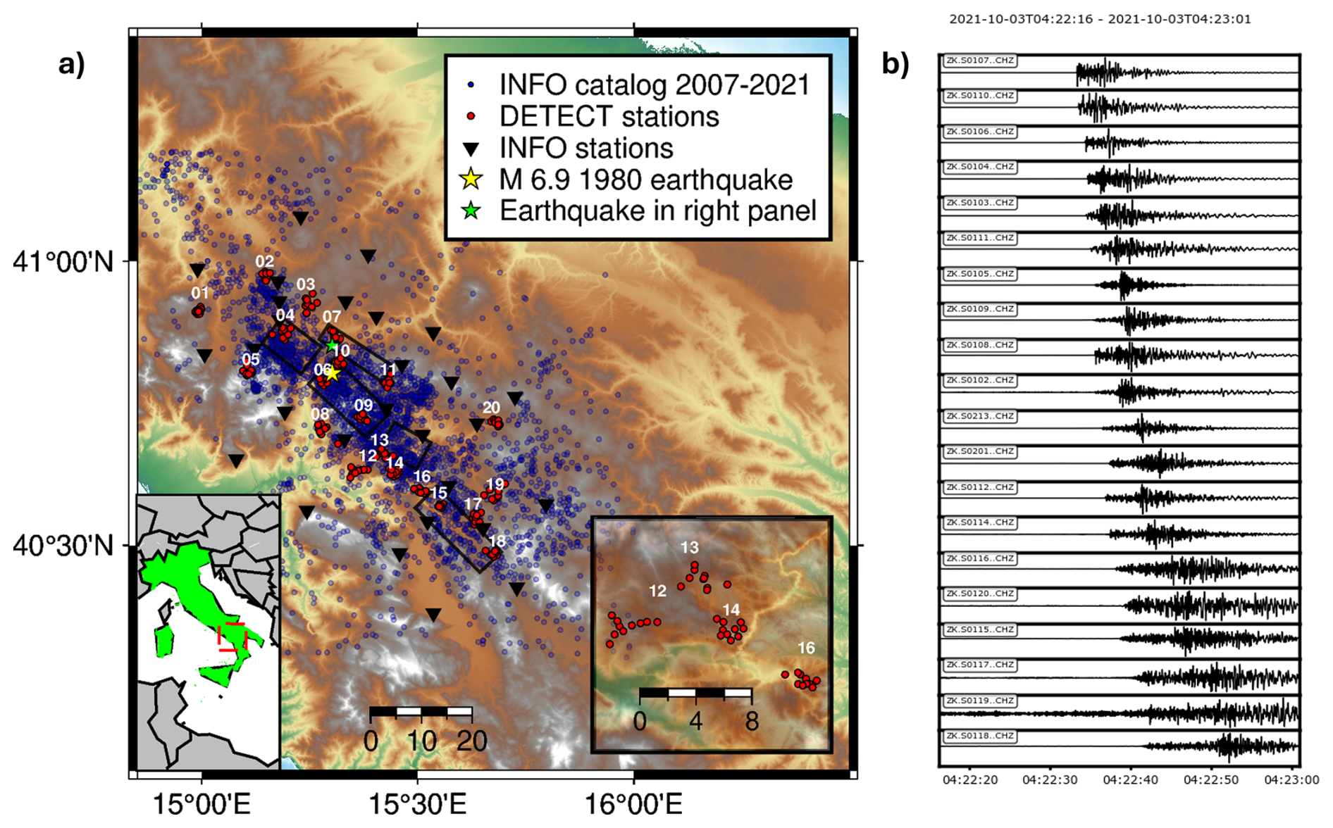
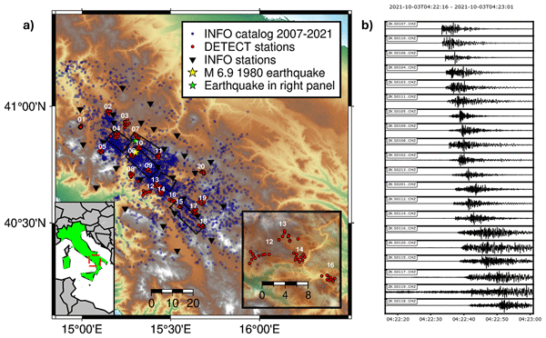
Figure 1(a) Map with all DETECT stations (red circles) with Array ID (name of hosting municipality is given in Table S1), blue circles indicate all events recorded by the INFO network (stations indicated with black triangles) from 2007 to 2021, black rectangles indicate the different fault segments (DISS Working Group, 2025) of the Mw 6.8 1980 Irpinia Earthquake (yellow star). The green star indicates the actual location of the M 2.3 of event occurred on 3 October 2021, recorded at all DETECT stations. The right-side inset highlights some examples of different array geometries for arrays 12, 13, 14 and 16. (b) Vertical component of velocimetric records at the broadband stations for the M 2.3 earthquake in panel (a).
As recorded by ISNet, the seismicity appears distributed in an area of approximately 3700 km2 (ca. 80 km × 46 km). The largest recent events ranged from Mw 3.4 in 2009 to Mw 4.1 in 2025. The hypocenters of the present-day earthquakes appear to be spread over a large crustal volume around the fault segments that generated the Mw 6.8 Irpinia earthquake (yellow star in Fig. 1). These earthquakes span depths from 2 to 20 km, with a higher density of events between 7 and 12 km in carbonate lithology. Therefore, the seismically active rock volume consists of the Apulian Platform carbonates and their basement. Occasionally, the seismicity in the area occurs as seismic sequences originating on structures oriented as the larger faults that generated the 1980 Irpinia earthquake (Stabile et al., 2012; Festa et al., 2021; Scotto di Uccio et al., 2024). These sequences in Irpinia appear either to occur on subparallel, smaller-scale faults or to rupture patch-wise on the main faults in segments that were locked during previous events (Palo et al., 2023; Scotto di Uccio et al., 2024).
Notably, this sector of the southern Apennines, which is far from active volcanism (>70 km), is characterized by the remarkable outgassing of deep-origin volatiles, with carbon dioxide (CO2) being the dominant gaseous species (Improta et al., 2014; Caracausi et al., 2022). Crustal fluids have been shown to play an active role in regional seismicity (Chiodini et al., 2004). In Irpinia, the background microseismicity and seismic sequences appear to be partially controlled by fluids of different origins (Amoroso et al., 2014, 2017; D'Agostino et al., 2018; Tarantino et al., 2024).
Recent studies that exploited the long-term monitoring of the microseismicity provided evidence of structural segmentation and insight into the evolution of both crustal and source properties, inferred from the medium properties (e.g., De Landro et al., 2022), the apparent stress (Picozzi et al., 2019), the stress drop (Picozzi et al., 2022b) and the ground motion intensity (Picozzi et al., 2022c).
Table 1Instruments used for the DETECT experiment as provided by GIPP (Grant Number 202119). Instrument (sensor) type information is also embedded in the second and third characters of the station codes: 01 for Trillium Compact 120, 02 for Mark L-4C-3D 1 Hz Geophone 3-C and 03–10 for 4.5 Hz Geophone 3-C (only 2 stations are not following this convention: S0203 and S1003 at Array #03, where the two sensors were swapped). The last access date for all URLs mentioned in this table is 14 October 2026.

DETECT was conceived using limited household funding from the University of Napoli Federico II (UniNA) and the Helmholtz Centre for Geosciences (GFZ), without additional third-party funding. The project leveraged the personnel and logistical resources available at all partner institutions. Despite the limited budget, the survey was designed to capture small events while integrating the coverage of the standard network. Building on the success of previous experiments in monitoring microseismicity and seismic tremor with small-scale arrays (Scala et al., 2022; Panebianco et al., 2024), we deployed 200 seismic stations in 20 arrays, each consisting of ten stations (Tables 1 and S1 in the Supplement, red dots in Fig. 1). The Geophysical Instrument Pool Potsdam (GIPP, https://www.gfz.de/gipp, last access: 14 October 2026) provided the seismic equipment for DETECT, and GFZ and UniNA provided all other necessary accessories to operate the stations. The first pilot array (ID 08, Table S1) was deployed in the epicentral area of the 1980 Mw 6.8 Irpinia earthquake in June 2021, with an initial sampling rate of 400 Hz. After preliminary analyses evaluating costs and benefits, the sampling rate was reduced to 200 Hz for the entire experiment.
During the preparation phase of the deployment, the municipality of Colliano (SA) organized and hosted an outreach event, in which researchers participating in the campaign presented the aims of the experiment to the mayors of other municipalities later involved in DETECT. This raised awareness among the local administrations, all of which supported the deployment of all the other arrays (Table S1). The arrays were installed between late August and late September 2021 by small crews (four crews of two to three people). The arrays were located in small municipalities in Irpinia for two reasons: (i) the local authorities and citizens were available to host the seismic stations, helping with scouting and guaranteeing the security of the sites while allowing the dissemination of knowledge about hazard and seismicity of the area; (ii) the arrays were installed as close as possible to the fault segments involved in the 1980 Mw 6.8 Irpinia earthquake (Fig. 1).
Consequently, the arrays had variable geometry optimized for the local conditions (dynamic map at https://geofon.gfz.de/waveform/archive/network.php?ncode=ZK&year=2021, last access: 14 October 2026, and inset in Fig. 1), and an approximate aperture size of 2 km. This size was envisaged based on the findings of De Landro et al. (2020), who assessed the potential of including similar arrays in monitoring systems for induced seismicity. They found that, for low noise levels, integrating seismic networks with small-scale arrays can achieve a magnitude detection threshold close to Mw 0 and small location errors (i.e., a few hundred meters for depths down to 8 km).
All the stations were equipped with CUBE 3 Digital recorders, and each array consisted of nine short-period sensors (eight 4.5 Hz Geophone 3-C and one Mark L-4C 3D 1 Hz Geophone 3-C) and one broadband seismometer (Trillium Compact 120). The right panel of Fig. 1 shows the vertical component of the ground motion records of the broadband sensors for a M 2.3 earthquake (green star). When possible, broadband stations were installed at sites with power supply or powered by solar panels. All the other stations were powered by 9 V/200 Ah or 9 V/175 Ah dry, super alkaline batteries. The expected battery life depends on many factors, such as the condition of the battery at the time of purchase and environmental conditions such as humidity and temperature (https://www.gfz.de/en/section/geophysical-imaging/infrastructure/geophysical-instrument-pool-potsdam-gipp/pool-components/powercalculation/cube-power, last access: 14 October 2026). As the average expected lifespan was around six months, the batteries were replaced halfway through the experiment. When possible, the sensors were installed in small holes and covered with a plastic crate, also containing the data logger and the battery (Fig. 2).
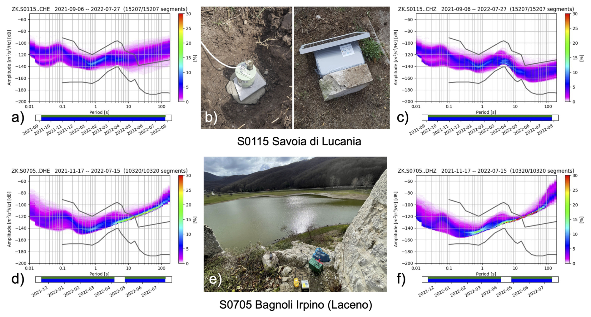
Figure 2Probability Density Functions (PDFs) computed for two example stations: upper panels for Savoia di Lucania, Array ID 15, station S01 equipped with Broad-Band sensor Trillium Compact 120, (a) East component, (b) picture of the installation, (c) vertical component, lower panels for Bagnoli Irpino (Laceno) Array ID 05, station S07 4.5 Hz Geophone 3-C (Table S1), (d) East component, (e) picture of the installation, (f) vertical component.
To limit power consumption, the experiment was realized without real-time data transmission. This required periodic visits to each station to download the acquired data.
The complete list of installed instruments (DETECT metadata) is available in both text and station_xml formats in various levels of resolution (station, channel, response) from the GEOFON data center (see the Data Availability section). The installation and data curation followed the guidelines by Heit et al. (2021) for a large number of stations, as in the Alps.
The crews visited the seismic stations three times (November–December 2021, March–April 2022, and July–August 2022) to retrieve data and replace batteries. During each visit, data were transferred from the dataloggers onto external storage devices and subsequently transferred to GEOFON for further processing. We collected 4.5 TB of data during the first recovery campaign, 4.3 TB during the second one, and 4.0 TB during the final campaign. The overall data availability for the period from 21 October 2021 to 11 July 2022 was 88 %. Data availability remained generally stable over time, except for short intervals preceding maintenance visits, when it temporarily decreased to 75 %–80 % due to internal storage saturation or battery depletion (Fig. 3a). Since individual arrays were installed within a few days, storage saturation issues occurred almost simultaneously at all stations of a single array (Fig. 3b and c).
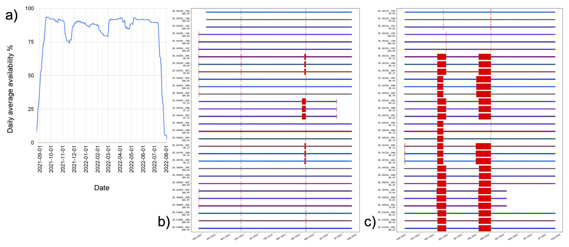
Figure 3(a) Overall daily average data availability for the entire network. (b, c) Station availability over the entire time span for two arrays, respectively 09 and 10 (Table S1).
To optimize the maintenance schedule, a traffic-light system was implemented within a webGIS platform, available throughout the experiment, indicating the time elapsed since the last data download for each station. This system enables efficient prioritization of field activities and route planning, resulting in significant savings in time and resources. In addition, a Telegram bot was developed to streamline communication and updates, while QR codes installed at each station facilitate rapid identification and interaction in the field.
GIPP tools were used for data conversion from Data-Cube to standard miniseed format (https://www.gfz.de/en/section/geophysical-imaging/infrastructure/geophysical-instrument-pool-potsdam-gipp/software/gipptoolsi, last access: 14 October 2026), using the default setup for timing. Due to steim2 compression, the volume of miniseed data was drastically reduced to 5.2 TB in the EIDA data archive, under the network code ZK (Bindi et al., 2021).
Data and metadata were managed in accordance with the GIPP/GEOFON policy using SeisComP (Helmholtz Centre Potsdam – GFZ German Research Centre for Geosciences and GEMPA GmbH, 2008) and other data management tools. The dataset was initially embargoed, with access restricted to partners directly involved in the seismic deployment. After a three-year embargo period, the data have been publicly released through the GFZ EIDA node.
To assess the noise level at all array stations, we computed median power spectral density (PSD) curves from the probability density functions (PDFs) for each channel (Fig. 2). The resulting curves are shown in Fig. 4. The first row collects PSD curves organized per sensor, including broadband sensors (Fig. 4a), 1 Hz velocimeters (Fig. 4b), and 4.5 Hz geophones (Fig. 4c).
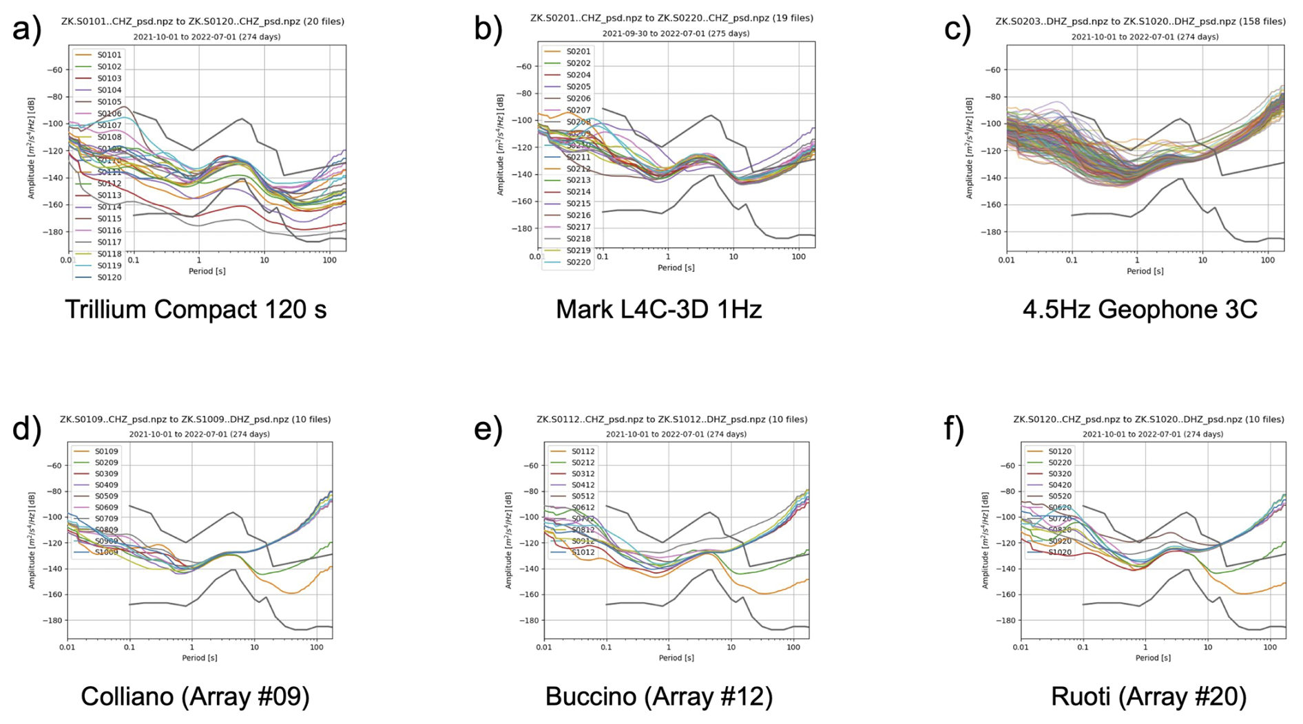
Below 10 Hz, the PSD curves of both the broadband and 1 Hz sensors lie well below the New High Noise Model (NHNM; Peterson, 1993). In contrast, the geophones exhibit higher noise levels, approaching the NHNM in the 0.1–1 s period domain. Noise variability persists at low frequencies. Several broadband sensor curves also fall below the New Low Noise Model (NLNM) and show stable performance at periods as long as 100 s. The 1 Hz sensors clearly resolve the secondary microseismic peak (McNamara and Buland, 2004), which is located around 5 s. Above 10 s, the sensors exhibit increased noise due to instrumental limitations. The 4.5 Hz geophones also capture the secondary microseismic peak, though their noise increase occurs at shorter periods. Examples of median PSD curves represented per single array are shown in the second row of Fig. 4 for arrays 09 (Fig. 4d), 12 (Fig. 4e) and 20 (Fig. 4f). In these cases, the variability of the median curves is much smaller, down to 4–5 s. Above this limit, the PSD curves diverge due to different instrumental noise at large periods (low frequencies), with curves from the geophones overcoming the reference noise curves.
The collected dataset of continuous waveforms offers a novel observation scale to investigate the characteristics of the seismicity in the area, shedding light on the decametric-size seismic sources for low-magnitude earthquakes.
A compelling example of this is provided by the enhanced catalog we compiled by applying advanced strategies. For earthquake characterization, we integrated machine learning and similarity-based approaches (Scotto di Uccio et al., 2023), together with the identification and relocation of earthquakes recorded during DETECT. This highlights the importance of deploying dense seismic arrays for earthquake monitoring.
The seismic catalog was initially obtained by scanning the waveforms with the machine learning technique EQTransformer (Mousavi et al., 2020), trained on the worldwide earthquake database STEAD (Mousavi et al., 2019), and then refined by the template matching approach EQCorrScan (Chamberlain et al., 2018), using the former catalog as the template set for the latter (Scotto di Uccio et al., 2023). Following the parameterization described in Scotto di Uccio et al. (2026), the DETECT catalog contains 3.6k events, a number comparable to decades of conventional monitoring, ranging from local magnitude Ml −1.2 to Ml 3.1, enhancing the standard catalog during the dense experiment by one order of magnitude (earthquake epicenters in Fig. 5).
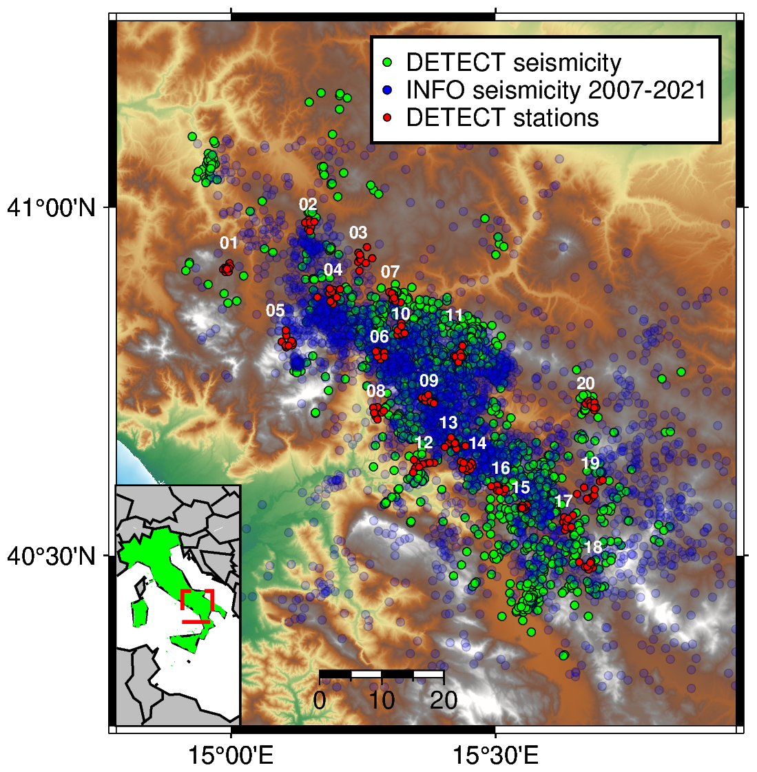
Figure 5Epicenters of earthquakes that occurred during the DETECT experiment (green dots), as from the seismic catalog of Scotto di Uccio et al. (2026). Blue shaded dots mark the epicenters of the earthquake in the long-term INFO catalog from 2007 to the start of the array deployment.
We associated ∼100k phase arrival times across the arrays within the catalog. Earthquake relocation revealed the occurrence of microseismicity in regions with high event densities identified by the standard INFO catalog. Analysis of the seismic catalog revealed a lower completeness threshold, down to −0.3, which lowered the corresponding value from the long-term catalog by more than one magnitude point, as expected by the initial feasibility analysis. Moreover, the b values of the two catalogs show similar slopes in the Gutenberg–Richter distribution. This indicates that the temporary deployment of dense arrays not only improves detection capability but also maintains statistical consistency with long-term earthquake catalogs, effectively extending the statistical characterization of seismicity to shorter time windows and lower magnitude events (Scotto di Uccio et al., 2026).
In this application, the seismic stations within each array were used independently, without exploiting array techniques such as beamforming and back-projection. These techniques can help increase the signal-to-noise ratio of the resulting waveforms and enhance the detectability of lower magnitude events. Additionally, phase arrival times associated with events that occurred during the DETECT experiment can be used to train or update, using transfer learning strategies, deep learning phase pickers on earthquakes with a lower magnitude range than the typical population of standard and/or global datasets.
The collected dataset is available at https://doi.org/10.14470/MX7576871994 (Bindi et al., 2021), Waveform data are available through the European Integrated Data Archive (EIDA) infrastructure (Strollo et al., 2021), under the International Federation of Digital Seismograph Networks (FDSN) network code ZK (Bindi et al., 2021). Data are curated and distributed by the GEOFON Data Center and are available under CC BY 4.0 license.
Waveform data from the ZK network (Bindi et al., 2021) can be accessed through the FDSN dataselect Web Service (https://www.fdsn.org/services, last access: 14 October 2026). To request specific time windows of data, a query can be constructed with parameters such as network code (net), station code (sta), channel (cha), start time (starttime), and end time (endtime).
For example, to retrieve a 3 min time window around the event in Fig. 1, including only the vertical channels of the Trillium Compact 120 and the Mark L-4C-3D 1 Hz Geophone:
-
https://geofon.gfz.de/fdsnws/dataselect/1/query?net=ZK&sta=*&cha=CHZ&starttime=2021-10-03T04:22:00&endtime=2021-10-03T04:25:00 (last access: 14 October 2026).
Waveform metadata are available via standard FDSN web services and formats (https://www.fdsn.org/services, last access: 14 October 2026) alongside other custom services and products. Station metadata for the ZK network can be accessed through the FDSN station Web Service in text format for station and channel levels, respectively:
-
http://geofon.gfz.de/fdsnws/station/1/query?starttime=2021-08-15T00:00:00&endtime=2022-08-15T00:00:00&network=ZK&station=*&level=station&format=text&nodata=404 (last access: 14 October 2026)
-
http://geofon.gfz.de/fdsnws/station/1/query?starttime=2021-08-15T00:00:00&endtime=2022-08-15T00:00:00&network=ZK&station=*&level=channel&format=text&nodata=404 (last access: 14 October 2026).
Metadata in stationXML format can be obtained using the following queries, respectively, for station, channel, and response levels:
-
http://geofon.gfz.de/fdsnws/station/1/query?starttime=2021-08-15T00:00:00&endtime=2022-08-15T00:00:00&network=ZK&station=*&level=station&format=xml&nodata=404 (last access: 14 October 2026)
-
http://geofon.gfz.de/fdsnws/station/1/query?starttime=2021-08-15T00:00:00&endtime=2022-08-15T00:00:00&network=ZK&station=*&level=channel&format=xml&nodata=404 (last access: 14 October 2026)
-
http://geofon.gfz.de/fdsnws/station/1/query?starttime=2021-08-15T00:00:00&endtime=2022-08-15T00:00:00&network=ZK&station=*&level=response&format=xml&nodata=404 (last access: 14 October 2026).
Additional data access tools include:
the interactive availability calendar view (2021–2022).
-
https://geofon.gfz.de/waveform/archive/data.php?ncode=ZK&year=2021 (last access: 14 October 2026)
the FDSN Availability web service:
-
https://geofon.gfz.de/fdsnws/availability/1/query?network=ZK&station=*&start=2021-08-15T00:00:00&end=2022-08-15T00:00:00 (last access: 14 October 2026)
the WFcatalog quality metrics (https://www.orfeus-eu.org/data/eida/webservices/wfcatalog/, last access: 14 October 2026): availability, RMS, gaps, overlaps, records, timing quality (Trani et al., 2016). For example, for station S0101, channel CHZ:
-
https://geofon.gfz.de/eidaws/wfcatalog/1/query?net=ZK&station=S0101&channel=CHZ&start=2021-08-15T00:00:00.000Z&end=2022-08-15T23:59:59.999Z&include=all (last access: 14 October 2026)
the Power Spectral Density (PSD) (example for station S0101, channel CHZ) as for the figures included in the annexes
-
https://geofon.gfz.de/eidaws/psd/1/histogram?&cmap=viridis&fontsize=12&grid=true&mean=true&noise=true&percentiles=false&&dpi=600&network=ZK&station=S0101&location=*&channel=CHZ&nodata=404&start=2021-08-15&end=2022-08-15 (last access: 14 October 2026).
Finally, the seismic catalog derived from the DETECT dataset by Scotto di Uccio et al. (2026) can be accessed via Zenodo at https://doi.org/10.5281/zenodo.15372023 (Scotto di Uccio et al., 2025) and is distributed under a Creative Commons Attribution 4.0 International license.
The DETECT experiment was a multi-institutional collaboration that promoted the concept of using microarrays in high seismic hazard regions to monitor seismicity over a short time scale. The pivotal idea behind the short-term dense array deployment was to offer a novel, lower spatial scale to potentially image and track the presence of crustal fluids by lowering the minimum magnitude of detectable earthquakes. Indeed, integrating small-scale seismic arrays within classic seismic networks and with novel approaches for data mining allows us to significantly improve the detection of microseismicity, identifying in just one year the number of detected events as from decades of conventional monitoring. The availability of enhanced seismic catalogs is indeed a fundamental prerequisite for improving our understanding of fault mechanics. From a logistical perspective, the main challenge revealed to be the scheduling and the rolling out of a well-coordinated maintenance plan over short time windows. Furthermore, involving citizens in seismic experiments and monitoring activities allowed us, on the one hand, to speed up the siting operations and increase the security of the instrumentation while, on the other hand, helped us to share knowledge on seismic risk, which can contribute to raising awareness, well-being and resilience. Temporary experiments, such as DETECT, can significantly help improve the knowledge about the propagation medium. Data collected during the DETECT survey has the potential to provide an enriched catalog that can be exploited to derive 4D (space and time) high-resolution tomographic images in velocity and attenuation to characterize variations of rock properties in the fluid-filled porous medium, where micro-seismicity is diffuse and large earthquakes can nucleate. This dataset could even be suitable for developing and testing ambient noise tomography repeated over time. Furthermore, as the evaluation of source parameters from standard monitoring networks is hindered by the effect of the anelastic attenuation, which filters out the high-frequency source radiation, we believe that the dense, near-fault networks recording at high sampling rates, as tested in DETECT, can help to disentangle source and propagation contributions. They also allow better estimation of local site attenuation factors, which in turn enables a more accurate assessment of the resolution limits of source parameters (Moratto et al., 2025), providing a better estimate of the epistemic uncertainties affecting the source scaling relationships. Beyond the waveform dataset, the availability of the enhanced catalog of Scotto di Uccio et al. (2026) substantially increases the scientific value of the dataset, providing a ready-to-use resource that enables a broad range of state-of-the-art analyses without requiring users to perform complex preprocessing and event characterization from scratch.
Regarding the monitoring infrastructure, the experimental setup of DETECT provides a useful strategy for a long-term monitoring approach, where dense measurements lasting for one year are repeated every 3 to 5 years. Repeating the experiment at regular time intervals allows tracking the evolution of the fault system over different time scales. Thus, DETECT can be used to establish a framework for discussing the potential development of a long-term project with other partners, aimed at covering the entire Italian territory with mobile seismic arrays.
We provide as Supplement:
-
Availability figures for each array (01–20, Table S1) generated with obspy-scan (Beyreuther et al., 2010). See Data Availability section.
-
Probability Density Functions (PDF) for all stations/components generated using obspy.signal.spectral_estimation.PPSD (Beyreuther et al., 2010). All images are also available from GEOFON data centre (see Data Availability section).
-
Power Spectral Densities computed to generate the PDF have been averaged over the entire time span and grouped in plots by array (01–20, Table S1) and by sensor type (Table 1). See Data Availability section.
-
Metadata for all ZK stations as provided by the standard fdsnws-station web service (text and xml formats) are also included (See Data Availability section).
-
List of municipalities hosting the seismic arrays (Table S1).
The supplement related to this article is available online at https://doi.org/10.5194/essd-18-7751-2026-supplement.
FSdU, AS, MP, GF, TAS, GMA, DB provided contributions to the conceptualization and finalization of the article. All Authors contributed to the collection of the actual data set presented. Regarding the figures: FSdU prepared Figs. 1 and 5. AS prepared Figs. 2–4.
The contact author has declared that none of the authors has any competing interests.
Publisher's note: Copernicus Publications remains neutral with regard to jurisdictional claims made in the text, published maps, institutional affiliations, or any other geographical representation in this paper. The authors bear the ultimate responsibility for providing appropriate place names. Views expressed in the text are those of the authors and do not necessarily reflect the views of the publisher.
We thank the two anonymous reviewers and the editor for their constructive comments and suggestions, which helped to improve the clarity and quality of the manuscript. We thank Karl-Heinz Jaeckel for all useful technical discussions and support during the preparation phase of the experiment. Data were processed using Obspy (Beyreuther et al., 2010) and figures were prepared using Python, Matplotlib and Matlab. This research has been supported by Geo-INQUIRE (Project Number 101058518). FSdU activity has been supported by the EU project TRANSFORM2 funded by the European Commission under project number 101188365 within the HORIZON-INFRA-2024-DEV-01 call. GF activity has been supported by “Advanced SeisMic InterferOmetry MethoDs and TechnologiEs for EngineeRiNg Seismology (MODERN)” project, granted by the Italian Ministry of University and Research (MUR) under the Italian Fund for Applied Sciences (FISA), Code: FISA-2022-00764. LE and MP activities have been supported by the “Monitoring Earth's Evolution and Tectonics (MEET)” project, funded by the Italian Ministry of University and Research (MUR) under the National Recovery and Resilience Plan (PNRR), Mission 4 “Education and Research”, Component 2 “From Research to Enterprise”, Investment 3.1 “Fund for the realization of an integrated system of research and innovation infrastructures” (Next Generation EU). TM activity has been supported by the “Geoscience Research Infrastructure of Italy (GRINT)” project funded by the Italian Ministry of University and Research (MUR) within the framework of the National Operational Programme (PON) Research and Innovation 2014–2020, code PIR01_00013.
We are grateful for the support of all the municipalities involved and other local authorities, local police, civil protection, etc. A special mention goes to the Municipality of Colliano (SA) for hosting and organising the first introductory event to involve all the other Municipalities. In particular, we thank the mayor in charge during the experiment, who made this possible, Adriano Goffredo, and the Councilor Giuseppe Scaglione for their extraordinary commitment to support the experiment and also for liaising with other Municipalities when needed. Finally, we owe a huge debt of gratitude to all the families who offered their private rooms and gardens to host and look after one of our stations, and to all the helping hands during the experiment.
The Geophysical Instrument Pool Potsdam (GIPP, https://www.gfz.de/gipp, last access: 14 October 2026) provided the instruments free of charge under grant no. 202119 (https://gipp.gfz.de/projects/view/754, last access: 14 October 2026). The GEOFON data centre provided the long-term data archiving, and the GFZ Helmholtz Centre for Geosciences (https://ror.org/04z8jg394, last access: 14 October 2026) financially supported the experiment with internal expedition funding. Data collection, organization and distribution and related research have been supported by the Italian Ministry of University and Research (MUR) under the EPOS-ITALIA JRU agreement and the Helmholtz-Zentrum Potsdam – Deutsches GeoForschungsZentrum GFZ (grant no. 202119).
This paper was edited by Andrea Rovida and reviewed by two anonymous referees.
Adil, M., Palo, M., Zollo, A., Orefice, A., and Dell'Elce, G.: Using Repeating Microearthquakes to Infer Medium Velocity Variations at Val d'Agri Area (Southern Italy), IEEE J. Select. Top. Appl. Earth Obs. Remote Sens., 19, 2189–2199, https://doi.org/10.1109/JSTARS.2025.3643734, 2025.
Adinolfi, G. M., Cesca, S., Picozzi, M., Heimann, S., and Zollo, A.: Detection of weak seismic sequences based on arrival time coherence and empiric network detectability: an application at a near fault observatory, Geophys. J. Int., 218, 2054–2065, https://doi.org/10.1093/gji/ggz248, 2019.
Amoroso, O., Ascione, A., Mazzoli, S., Virieux, J., and Zollo, A.: Seismic imaging of a fluid storage in the actively extending Apennine mountain belt, southern Italy, Geophys. Res. Lett., 41, 3802–3809, https://doi.org/10.1002/2014GL060070, 2014.
Amoroso, O., Russo, G., De Landro, G., Zollo, A., Garambois, S., Mazzoli, S., Parente, M., and Virieux, J.: From velocity and attenuation tomography to rock physical modeling: Inferences on fluid-driven earthquake processes at the Irpinia fault system in southern Italy, Geophys. Res. Lett., 44, 6752–6760, https://doi.org/10.1002/2016GL072346, 2017.
Bello, S., de Nardis, R., Scarpa, R., Brozzetti, F., Cirillo, D., Ferrarini, F., di Lieto, B., Arrowsmith, R. J., and Lavecchia, G.: Fault Pattern and Seismotectonic Style of the Campania – Lucania 1980 Earthquake (Mw 6.9, Southern Italy): New Multidisciplinary Constraints, Front. Earth Sci., 8, https://doi.org/10.3389/feart.2020.608063, 2021.
Ben-Zion, Y., Vernon, F. L., Ozakin, Y., Zigone, D., Ross, Z. E., Meng, H., White, M., Reyes, J., Hollis, D., and Barklage, M.: Basic data features and results from a spatially dense seismic array on the San Jacinto fault zone, Geophys. J. Int., 202, 370–380, https://doi.org/10.1093/gji/ggv142, 2015.
Bernard, P. and Zollo, A.: The Irpinia (Italy) 1980 earthquake: Detailed analysis of a complex normal faulting, J. Geophys. Res.-Solid, 94, 1631–1647, https://doi.org/10.1029/JB094iB02p01631, 1989.
Beyreuther, M., Barsch, R., Krischer, L., Megies, T., Behr, Y., and Wassermann, J.: ObsPy: A Python Toolbox for Seismology, Seismol. Res. Lett., 81, 530–533, https://doi.org/10.1785/gssrl.81.3.530, 2010.
Bindi, D., Cotton, F., Picozzi, M., and Zollo, A.: The Irpinia seismic Array, GFZ Data Services, Dataset/Seismic Network [data set], https://doi.org/10.14470/MX7576871994, 2021.
Caracausi, A., Buttitta, D., Picozzi, M., Paternoster, M., and Stabile, T. A.: Earthquakes control the impulsive nature of crustal helium degassing to the atmosphere, Commun. Earth Environ., 3, 224, https://doi.org/10.1038/s43247-022-00549-9, 2022.
Chamberlain, C. J., Hopp, C. J., Boese, C. M., Warren-Smith, E., Chambers, D., Chu, S. X., Michailos, K., and Townend, J.: EQcorrscan: Repeating and Near-Repeating Earthquake Detection and Analysis in Python, Seismol. Res. Lett., 89, 173–181, https://doi.org/10.1785/0220170151, 2018.
Chiaraluce, L., Festa, G., Bernard, P., Caracausi, A., Carluccio, I., Clinton, J., Di Stefano, R., Elia, L., Evangelidis, C., Ergintav, S., Jianu, O., Kaviri, G., Marmureanu, A., Sebela, S., and Sokos, E.: The Near Fault Observatory community in Europe: a new resource for faulting and hazard studies, Array, 65, DM316, https://doi.org/10.4401/ag-8778, 2022.
Chiodini, G., Cardellini, C., Amato, A., Boschi, E., Caliro, S., Frondini, F., and Ventura, G.: Carbon dioxide Earth degassing and seismogenesis in central and southern Italy, Geophys. Res. Lett., 31, https://doi.org/10.1029/2004GL019480, 2004.
D'Agostino, N., Silverii, F., Amoroso, O., Convertito, V., Fiorillo, F., Ventafridda, G., and Zollo, A.: Crustal Deformation and Seismicity Modulated by Groundwater Recharge of Karst Aquifers, Geophys. Res. Lett., 45, 12253—12262, https://doi.org/10.1029/2018GL079794, 2018.
De Landro, G., Picozzi, M., Russo, G., Adinolfi, G. M., and Zollo, A.: Seismic networks layout optimization for a high-resolution monitoring of induced micro-seismicity, J. Seismol., 24, 953–966, https://doi.org/10.1007/s10950-019-09880-9, 2020.
De Landro, G., Amoroso, O., Russo, G., D'Agostino, N., Esposito, R., Emolo, A., and Zollo, A.: Decade-long monitoring of seismic velocity changes at the Irpinia fault system (southern Italy) reveals pore pressure pulsations, Sci. Rep., 12, 1247, https://doi.org/10.1038/s41598-022-05365-x, 2022.
DISS Working Group: Database of Individual Seismogenic Sources (DISS), Version 3.3.1: A compilation of potential sources for earthquakes larger than M 5.5 in Italy and surrounding areas, INGV – Istituto Nazionale di Geofisica e Vulcanologia, https://doi.org/10.13127/diss3.3.1, 2025.
Di Luccio, F., Ventura, G., Di Giovambattista, R., Piscini, A., and Cinti, F. R.: Normal faults and thrusts reactivated by deep fluids: The 6 April 2009 M 6.3 L'Aquila earthquake, central Italy, J. Geophys. Res.-Solid, 115, https://doi.org/10.1029/2009JB007190, 2010.
Festa, G., Adinolfi, G. M., Caruso, A., Colombelli, S., De Landro, G., Elia, L., Emolo, A., Picozzi, M., Scala, A., Carotenuto, F., Gammaldi, S., Iaccarino, A. G., Nazeri, S., Riccio, R., Russo, G., Tarantino, S., and Zollo, A.: Insights into Mechanical Properties of the 1980 Irpinia Fault System from the Analysis of a Seismic Sequence, Geosciences, 11, 28, https://doi.org/10.3390/geosciences11010028, 2021.
Gradon, C., Roux, P., Moreau, L., Lecointre, A., and Ben Zion, Y.: Characterization with dense array data of seismic sources in the shallow part of the San Jacinto fault zone, Geophys. J. Int., 224, 1133–1140, https://doi.org/10.1093/gji/ggaa411, 2020.
Heit, B., Cristiano, L., Haberland, C., Tilmann, F., Pesaresi, D., Jia, Y., Hausmann, H., Hemmleb, S., Haxter, M., Zieke, T., Jaeckl, K.-H., Schloemer, A., and Weber, M.: The SWATH-D seismological network in the Eastern Alps, Seismol. Soc. Am., 92, 1592–1609, https://doi.org/10.1785/0220200377, 2021.
Helmholtz Centre Potsdam – GFZ German Research Centre for Geosciences and GEMPA GmbH: The SeisComP seismological software package, GFZ [code], https://doi.org/10.5880/GFZ.2.4.2020.003, 2008.
Iannaccone, G., Zollo, A., Elia, L., Convertito, V., Satriano, C., Martino, C., Festa, G., Lancieri, M., Bobbio, A., Stabile, T. A., Vassallo, M., and Emolo, A: A prototype system for earthquake early-warning and alert management in southern Italy, Bull. Earthq. Eng., 8, 1105–1129, https://doi.org/10.1007/s10518-009-9131-8, 2010.
Improta, L., De Gori, P., and Chiarabba, C.: New insights into crustal structure, Cenozoic magmatism, CO2 degassing, and seismogenesis in the southern Apennines and Irpinia region from local earthquake tomography, J. Geophys. Res.-Solid, 119, 8283–8311, https://doi.org/10.1002/2013JB010890, 2014.
McNamara, D. E. and Buland, R. P.: Ambient Noise Levels in the Continental United States, Bull. Seismol. Soc. Am., 94, 1517–1527, https://doi.org/10.1785/012003001, 2004.
Moratto, L., Panebianco, S., Satriano, C., Stabile, T. A., and Priolo, E.: Using ambient noise k0 estimation to improve microearthquake source parameters assessment in the High Agri Valley, Geophys. J. Int., 242, ggaf191, https://doi.org/10.1093/gji/ggaf191, 2025.
Mousavi, S. M., Sheng, Y., Zhu, W., and Beroza, G. C.: STanford EArthquake Dataset (STEAD): A Global Data Set of Seismic Signals for AI, IEEE Access, 7, 179464–179476, https://doi.org/10.1109/ACCESS.2019.2947848, 2019.
Mousavi, S. M., Ellsworth, W. L., Zhu, W., Chuang, L. Y., and Beroza, G. C.: Earthquake transformer – an attentive deep-learning model for simultaneous earthquake detection and phase picking, Nat. Commun., 11, 3952, https://doi.org/10.1038/s41467-020-17591-w, 2020.
Palo, M., Picozzi, M., De Landro, G., and Zollo, A.: Microseismicity clustering and mechanic properties reveal fault segmentation in southern Italy, Tectonophysics, 856, 229849, https://doi.org/10.1016/j.tecto.2023.229849, 2023.
Panebianco, S., Satriano, C., Vivone, G., Picozzi, M., Strollo, A., and Stabile, T. A.: Automated Detection and Machine Learning-Based Classification of Seismic Tremors Associated With a Non-Volcanic Gas Emission (Mefite d'Ansanto, Southern Italy), Geochem. Geophy. Geosy., 25, e2023GC011286, https://doi.org/10.1029/2023GC011286, 2024.
Peterson, J.: Observations and modeling of seismic background noise, US Geol. Surv. Open-File Rept. 93, 322, 95, US Geological Survey, https://doi.org/10.3133/ofr93322, 1993.
Picozzi, M., Milkereit, C., Fleming, K., Çakti, E., and Zschau, J.: A generalized zero-lag cross-correlation approach for Rapid Earthquake Localization (REL): the example of the Istanbul Megacity Rapid Response System, J. Seismol., 15, 557–578, https://doi.org/10.1007/s10950-011-9232-0, 2011.
Picozzi, M., Bindi, D., Zollo, A., Festa, G., and Spallarossa, D.: Detecting long-lasting transients of earthquake activity on a fault system by monitoring apparent stress, ground motion and clustering, Sci. Rep., 9, 16268, https://doi.org/10.1038/s41598-019-52756-8, 2019.
Picozzi, M., Spallarossa, D., Iaccarino, A. G., and Bindi, D.: Temporal Evolution of Radiated Energy to Seismic Moment Scaling During the Preparatory Phase of the Mw 6.1, 2009 L'Aquila Earthquake (Italy), Geophys. Res. Lett., 49, e2021GL097382, https://doi.org/10.1029/2021GL097382, 2022a.
Picozzi, M., Bindi, D., Festa, G., Cotton, F., Scala, A., and D'Agostino, N.: Spatiotemporal Evolution of Microseismicity Seismic Source Properties at the Irpinia Near-Fault Observatory, Southern Italy, Bull. Seismol. Soc. Am., 112, 226–242, https://doi.org/10.1785/0120210064, 2022b.
Picozzi, M., Cotton, F., Bindi, D., Emolo, A., Maria Adinolfi, G., Spallarossa, D., and Zollo, A.: Spatiotemporal Evolution of Ground-Motion Intensity at the Irpinia Near-Fault Observatory, Southern Italy, Bull. Seismol. Soc. Am., 112, 243–261, https://doi.org/10.1785/0120210153, 2022c.
Rost, S. and Thomas, C.: Improving Seismic Resolution Through Array Processing Techniques, Surv. Geophys., 30, 271–299, https://doi.org/10.1007/s10712-009-9070-6, 2009.
Rovida, A., Locati, M., Camassi, R., Lolli, B., and Gasperini, P.: The Italian earthquake catalogue CPTI15, Bull. Earthq. Eng., 18, 2953–2984, https://doi.org/10.1007/s10518-020-00818-y, 2020.
Rovida, A., Locati, M., Camassi, R., Lolli, B., Gasperini, P., and Antonucci, A.: Catalogo Parametrico dei Terremoti Italiani (CPTI15), versione 4.0, INGV – Istituto Nazionale di Geofisica e Vulcanologia [data set], https://doi.org/10.13127/cpti/cpti15.4, 2022.
Scala, A., Adinolfi, G. M., Picozzi, M., Scotto Di Uccio, F., Festa, G., De Landro, G., Priolo, E., Parolai, S., Riccio, R., and Romanelli, M.: Monitoring the Microseismicity through a Dense Seismic Array and a Similarity Search Detection Technique: Application to the Seismic Monitoring of Collalto Gas-Storage, North Italy, Energies, 15, 3504, https://doi.org/10.3390/en15103504, 2022.
Scotto di Uccio, F., Scala, A., Festa, G., Picozzi, M., and Beroza, G. C.: Comparing and integrating artificial intelligence and similarity search detection techniques: application to seismic sequences in Southern Italy, Geophys. J. Int., 233, 861–874, https://doi.org/10.1093/gji/ggac487, 2023.
Scotto di Uccio, F., Michele, M., Strumia, C., Supino, M., Beroza, G. C., Chiaraluce, L., D'Agostino, N., and Festa, G.: Characterization and Evolution of Seismic Sequences in the Normal Fault Environment of the Southern Apennines, J. Geophys. Res.-Solid, 129, e2023JB028644, https://doi.org/10.1029/2023JB028644, 2024.
Scotto di Uccio, F., Muzellec, T., Scala, A., De Landro, G., Camanni, G., Carotenuto, F., Elia, L., Picozzi, M., Zollo, A., Strumia, C., Beroza, G., and Festa, G.: Enhanced seismic catalog for the seismicity observed during the DETECT experiment, Southern Italy, Zenodo [data set], https://doi.org/10.5281/zenodo.15372023, 2025.
Scotto di Uccio, F., Muzellec, T., Scala, A., De Landro, G., Camanni, G., Carotenuto, F., Elia, L., Picozzi, M., Zollo, A., Strumia, C., Beroza, G. C., and Festa, G.: Enhancing the resolution of microseismicity through dense array monitoring in complex extensional settings, Sci. Rep., 16, 5639, https://doi.org/10.1038/s41598-026-35586-3, 2026.
Stabile, T. A., Satriano, C., Orefice, A., Festa, G., and Zollo, A.: Anatomy of a microearthquake sequence on an active normal fault, Sci. Rep., 2, 410, https://doi.org/10.1038/srep00410, 2012.
Stabile, T. A., Vlček, J., Wcisło, M., and Serlenga, V.: Analysis of the 2016–2018 fluid-injection induced seismicity in the High Agri Valley (southern Italy) from improved detections using template matching, Sci. Rep., 11, 20630, https://doi.org/10.1038/s41598-021-00047-6, 2021.
Strollo, A., Cambaz, D., Clinton, J., Danecek, P., Evangelidis, C. P., Marmureanu, A., Ottemöller, L., Pedersen, H., Sleeman, R., Stammler, K., Armbruster, D., Bienkowski, J., Boukouras, K., Evans, P. L., Fares, M., Neagoe, C., Heimers, S., Heinloo, A., Hoffmann, M., Kaestli, P., Lauciani, V., Michalek, J., Muhire, E. O., Ozer, M., Palangeanu, L., Pardo, C., Quinteros, J., Quintiliani, M., Jara-Salvador, J. A., Schaeffer, J., Schloemer, A., and Triantafyllis, N.: EIDA: The European integrated data archive and service infrastructure within ORFEUS, Seismol. Soc. Am., 92, 1788–1795, https://doi.org/10.1785/0220200413, 2021.
Tarantino, S., Poli, P., D'Agostino, N., Vassallo, M., Festa, G., Ventafridda, G., and Zollo, A.: Non-linear elasticity, earthquake triggering and seasonal hydrological forcing along the Irpinia fault, Southern Italy, Nat. Commun., 15, 9821, https://doi.org/10.1038/s41467-024-54094-4, 2024.
Trani, L., Sleeman, R., Koymans, M., and EIDA team: WFCatalog Web Service Specification, version 0.22, https://www.orfeus-eu.org/documents/WFCatalog_Specification-v0.22.pdf (last access: 14 October 2026), 2016.
- Abstract
- Introduction
- The DETECT target region
- Network design, deployment, and operation
- Data collection and curation
- Preliminary data analysis and products
- Data availability
- Conclusions
- Author contributions
- Competing interests
- Disclaimer
- Acknowledgements
- Financial support
- Review statement
- References
- Supplement