Articles | Volume 18, issue 10
https://doi.org/10.5194/essd-18-7719-2026
© Author(s) 2026. This work is distributed under
the Creative Commons Attribution 4.0 License.
the Creative Commons Attribution 4.0 License.
https://doi.org/10.5194/essd-18-7719-2026
© Author(s) 2026. This work is distributed under
the Creative Commons Attribution 4.0 License.
the Creative Commons Attribution 4.0 License.
Data description article
| 
26 Oct 2026
Data description article |
| 26 Oct 2026
| 26 Oct 2026
FineKarstAGB: a 30 m resolution aboveground biomass dataset for Southwest China derived by upscaling plot-level inventory using sub-meter GaoFen satellite data
Yixiang Li
State Key Laboratory of Remote Sensing and Digital Earth, Aerospace Information Research Institute, Chinese Academy of Sciences, Beijing 100101, China
College of Resources and Environment, University of Chinese Academy of Sciences, Beijing 100049, China

State Key Laboratory of Remote Sensing and Digital Earth, Aerospace Information Research Institute, Chinese Academy of Sciences, Beijing 100101, China
Zhengchao Chen
State Key Laboratory of Remote Sensing and Digital Earth, Aerospace Information Research Institute, Chinese Academy of Sciences, Beijing 100101, China
Caixia Liu
State Key Laboratory of Remote Sensing and Digital Earth, Aerospace Information Research Institute, Chinese Academy of Sciences, Beijing 100101, China
Xuan Yang
State Key Laboratory of Remote Sensing and Digital Earth, Aerospace Information Research Institute, Chinese Academy of Sciences, Beijing 100101, China
Xiaowei Tong
Institute of Subtropical Agriculture, Chinese Academy of Sciences, Changsha 410125, China
Guangxi Key Laboratory of Karst Ecological Processes and Services, Huanjiang Observation and Research Station for Karst Ecosystems, Chinese Academy of Sciences, Huanjiang 547100, Guangxi, China
Martin Brandt
Department of Geosciences and Natural Resource Management, University of Copenhagen, Copenhagen, Denmark
Zhaoming Wu
State Key Laboratory of Remote Sensing and Digital Earth, Aerospace Information Research Institute, Chinese Academy of Sciences, Beijing 100101, China
College of Resources and Environment, University of Chinese Academy of Sciences, Beijing 100049, China
Zeqing Wang
State Key Laboratory of Remote Sensing and Digital Earth, Aerospace Information Research Institute, Chinese Academy of Sciences, Beijing 100101, China
College of Resources and Environment, University of Chinese Academy of Sciences, Beijing 100049, China
Huaming Gao
State Key Laboratory of Remote Sensing and Digital Earth, Aerospace Information Research Institute, Chinese Academy of Sciences, Beijing 100101, China
College of Resources and Environment, University of Chinese Academy of Sciences, Beijing 100049, China
Xiaoyi Wang
State Key Laboratory of Tibetan Plateau Earth System, Resources and Environment, Institute of Tibetan Plateau Research, Chinese Academy of Sciences, Beijing 100085, China
Sizhuo Li
Department of Geosciences and Natural Resource Management, University of Copenhagen, Copenhagen, Denmark
Xin Xu
Institute of Subtropical Agriculture, Chinese Academy of Sciences, Changsha 410125, China
Department of Geosciences and Natural Resource Management, University of Copenhagen, Copenhagen, Denmark
Siyu Liu
Department of Geosciences and Natural Resource Management, University of Copenhagen, Copenhagen, Denmark
Related authors
No articles found.
Nora Linscheid, Laura Mayer, Chiara Aquino, Manuela Balzarolo, Maria Vincenza Chiriacò, Mélanie Juillard, Martin Brandt, Emilio Chuvieco, Philippe Ciais, Maoyuan Feng, Rasmus Fensholt, Teja Kattenborn, Amin Khairoun, Katja Kowalski, Siyu Liu, Joachim Maack, Clemens Mosig, Pierre Regnier, Cornelius Senf, Alba Viana-Soto, Yidi Xu, Yanzi Yan, and Ana Bastos
EGUsphere, https://doi.org/10.5194/egusphere-2026-6189, https://doi.org/10.5194/egusphere-2026-6189, 2026
This preprint is open for discussion and under review for Earth Observation (EO).
Short summary
Short summary
Despite the recent strong reduction in European forest carbon uptake, a comparison of EU forest carbon losses from different datasets is still lacking. We quantify these carbon sink losses combining new high-resolution Earth Observation estimates of forest disturbance, EO-based bookkeeping models, atmospheric CO2 inversions, and National Greenhouse Gas Inventories (NGHGI). We highlight how EO and NGHGIs can benefit each other in better quantifying C losses in a comprehensive and timely manner.
Carl Stadie, Ingmar Nitze, Begüm Demir, Martin Stefan Brandt, and Guido Grosse
EGUsphere, https://doi.org/10.5194/egusphere-2026-4074, https://doi.org/10.5194/egusphere-2026-4074, 2026
Short summary
Short summary
Driftwood piles up along Arctic coasts, storing carbon and shaping habitats, but mapping it automatically is difficult. We compared three artificial intelligence models on aerial photos and satellite images, repeating each test many times to capture natural training variation. Image resolution mattered far more than which model was used, and testing only once, as is common, gave misleading results. Our approach offers a more reliable way to choose mapping tools for similar Arctic features.
Rachel Nubwimana, Martin Brandt, Philippe Ciais, Maurice Mugabowindekwe, Sizhuo Li, Andrew Davies, Dimitri Gominski, Rasmus Fensholt, Sassan Saatchi, and Fabian Gieseke
EGUsphere, https://doi.org/10.5194/egusphere-2026-2924, https://doi.org/10.5194/egusphere-2026-2924, 2026
Short summary
Short summary
Trees outside forests; in savannas, farmlands, and drylands are largely invisible in global carbon maps. We developed a model that learns to spot trees in satellite photos and estimate how much carbon they store, trained only on rough existing maps without any manual labeling. Our maps turned out far more accurate than the maps it learned from, showing that smarter analysis of satellite imagery can reveal the hidden carbon stored in the world's overlooked trees.
Jinan Shi, Jiaxin Li, Lianru Gao, Siyu Liu, Rasmus Fensholt, Philippe Ciais, Xiaojun Li, Qiangqiang Yuan, Jean-Pierre Wigneron, and Lei Fan
Earth Syst. Sci. Data Discuss., https://doi.org/10.5194/essd-2026-193, https://doi.org/10.5194/essd-2026-193, 2026
Revised manuscript under review for ESSD
Short summary
Short summary
Satellite microwaves help monitor global vegetation, but existing data is too coarse.We enhanced it using higher-resolution information from a biomass map. This produced monthly 5-kilometer resolution data of tropical vegetation optical depth from 2015 to 2021. Our results show the enhanced data accurately captures vegetation dynamics and detects forest disturbances like clearing. By providing this finer-scale dataset, our work supports better local monitoring and protection of ecosystems.
Pengchao Zhang, Yi Luo, Dan Liu, Xiaoyi Wang, and Tao Wang
Earth Syst. Sci. Data, 17, 5557–5570, https://doi.org/10.5194/essd-17-5557-2025, https://doi.org/10.5194/essd-17-5557-2025, 2025
Short summary
Short summary
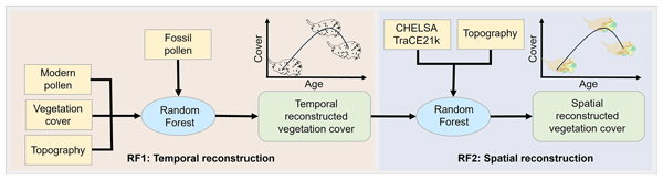
We present the first continuous reconstruction of vegetation on the Tibetan Plateau, spanning from the last deglaciation to the preindustrial era. Using fossil pollen records and statistical models, we mapped changes across space and time. The dataset shows how forests, grasslands, and alpine ecosystems shifted over millennia, offering insights into past climate–vegetation interactions and improving future climate and land-use research.
Dan Gao, Xiaofang Wu, Zhijin Wen, Yue Xu, and Zhengchao Chen
ISPRS Ann. Photogramm. Remote Sens. Spatial Inf. Sci., X-1-2024, 83–90, https://doi.org/10.5194/isprs-annals-X-1-2024-83-2024, https://doi.org/10.5194/isprs-annals-X-1-2024-83-2024, 2024
Chong Liu, Xiaoqing Xu, Xuejie Feng, Xiao Cheng, Caixia Liu, and Huabing Huang
Earth Syst. Sci. Data, 15, 133–153, https://doi.org/10.5194/essd-15-133-2023, https://doi.org/10.5194/essd-15-133-2023, 2023
Short summary
Short summary
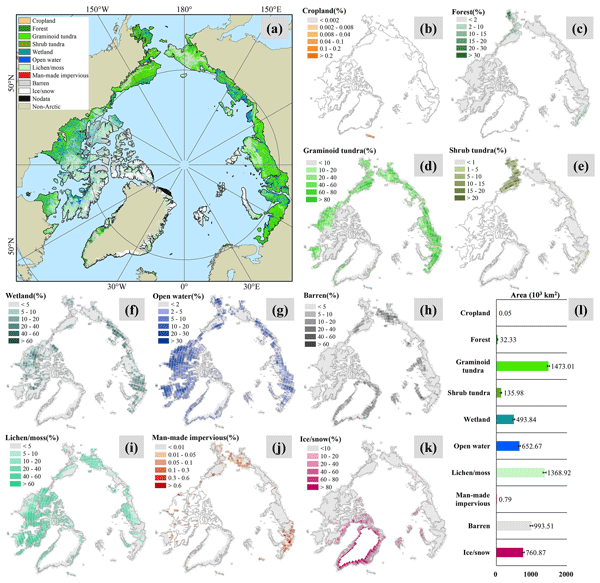
Rapid Arctic changes are increasingly influencing human society, both locally and globally. Land cover offers a basis for characterizing the terrestrial world, yet spatially detailed information on Arctic land cover is lacking. We employ multi-source data to develop a new land cover map for the circumpolar Arctic. Our product reveals regionally contrasting biome distributions not fully documented in existing studies and thus enhances our understanding of the Arctic’s terrestrial system.
M. C. A. Picoli, J. Radoux, X. Tong, A. Bey, P. Rufin, M. Brandt, R. Fensholt, and P. Meyfroidt
Int. Arch. Photogramm. Remote Sens. Spatial Inf. Sci., XLIII-B3-2022, 975–981, https://doi.org/10.5194/isprs-archives-XLIII-B3-2022-975-2022, https://doi.org/10.5194/isprs-archives-XLIII-B3-2022-975-2022, 2022
Cited articles
Araza, A., De Bruin, S., Herold, M., Quegan, S., Labriere, N., Rodriguez-Veiga, P., Avitabile, V., Santoro, M., Mitchard, E. T., Ryan, C. M., Phillips, O. L., Willcock, S., Verbeeck, H., Carreiras, J., Hein, L., Schelhaas, M.-J., Pacheco-Pascagaza, A. M., Da Conceição Bispo, P., Laurin, G. V., Vieilledent, G., Slik, F., Wijaya, A., Lewis, S. L., Morel, A., Liang, J., Sukhdeo, H., Schepaschenko, D., Cavlovic, J., Gilani, H., and Lucas, R.: A Comprehensive Framework for Assessing the Accuracy and Uncertainty of Global Above-Ground Biomass Maps, Remote Sens. Environ., 272, 112917, https://doi.org/10.1016/j.rse.2022.112917, 2022. a
Brandt, M., Yue, Y., Wigneron, J. P., Tong, X., Tian, F., Jepsen, M. R., Xiao, X., Verger, A., Mialon, A., Al-Yaari, A., Wang, K., and Fensholt, R.: Satellite-Observed Major Greening and Biomass Increase in South China Karst during Recent Decade, Earth's Future, 6, 1017–1028, https://doi.org/10.1029/2018EF000890, 2018. a
Brovkina, O., Novotny, J., Cienciala, E., Zemek, F., and Russ, R.: Mapping Forest Aboveground Biomass Using Airborne Hyperspectral and LiDAR Data in the Mountainous Conditions of Central Europe, Ecol. Eng., 100, 219–230, https://doi.org/10.1016/j.ecoleng.2016.12.004, 2017. a
Cai, Y., Xu, X., Zhu, P., Nie, S., Wang, C., Xiong, Y., and Liu, X.: Unveiling Spatiotemporal Tree Cover Patterns in China: The First 30 m Annual Tree Cover Mapping from 1985 to 2023, ISPRS J. Photogramm., 216, 240–258, https://doi.org/10.1016/j.isprsjprs.2024.08.001, 2024a. a
Cai, Y., Zhu, P., Xu, X., Li, X., Zhang, H., Nie, S., Wang, C., Wang, J., Shen, Q., Li, B., Wu, C., Liu, X., and Chen, Y.: CFATD: The First High-Spatiotemporal-Resolution Mapping of Forest Aboveground Biomass in China from 1985 to 2023 (Part VI: 2022–2023), Zenodo [data set], https://doi.org/10.5281/zenodo.12747329, 2024b. a, b, c, d, e, f, g, h, i, j, k, l, m, n
Cai, Y., Zhu, P., Li, X., Liu, X., Chen, Y., Shen, Q., Xu, X., Zhang, H., Nie, S., Wang, C., Wang, J., Li, B., Wu, C., and Zhuang, H.: Dynamics of China's forest carbon storage: the first 30 m annual aboveground biomass mapping from 1985 to 2023, Earth Syst. Sci. Data, 17, 6993–7018, https://doi.org/10.5194/essd-17-6993-2025, 2025. a, b, c
Campbell, M. J., Eastburn, J. F., Brewer, S. C., and Dennison, P. E.: Deep Learning and Machine Learning Enable Broad-Scale Woodland Height, Cover, and Biomass Mapping, ISPRS J. Photogramm., 226, 187–203, https://doi.org/10.1016/j.isprsjprs.2025.05.016, 2025. a
Chang, Z., Hobeichi, S., Wang, Y.-P., Tang, X., Abramowitz, G., Chen, Y., Cao, N., Yu, M., Huang, H., Zhou, G., Wang, G., Ma, K., Du, S., Li, S., Han, S., Ma, Y., Wigneron, J.-P., Fan, L., Saatchi, S. S., and Yan, J.: New Forest Aboveground Biomass Maps of China Integrating Multiple Datasets, Remote Sens., 13, https://doi.org/10.3390/rs13152892, 2021. a
Chave, J., Réjou-Méchain, M., Búrquez, A., Chidumayo, E., Colgan, M. S., Delitti, W. B. C., Duque, A., Eid, T., Fearnside, P. M., Goodman, R. C., Henry, M., Martínez-Yrízar, A., Mugasha, W. A., Muller-Landau, H. C., Mencuccini, M., Nelson, B. W., Ngomanda, A., Nogueira, E. M., Ortiz-Malavassi, E., Pélissier, R., Ploton, P., Ryan, C. M., Saldarriaga, J. G., and Vieilledent, G.: Improved Allometric Models to Estimate the Aboveground Biomass of Tropical Trees, Glob. Change Biol., 20, 3177–3190, https://doi.org/10.1111/gcb.12629, 2014. a
Chen, C., Park, T., Wang, X., Piao, S., Xu, B., Chaturvedi, R. K., Fuchs, R., Brovkin, V., Ciais, P., Fensholt, R., Tømmervik, H., Bala, G., Zhu, Z., Nemani, R. R., and Myneni, R. B.: China and India Lead in Greening of the World through Land-Use Management, Nat. Sustain., 2, 122–129, https://doi.org/10.1038/s41893-019-0220-7, 2019. a
Cheng, K., Yang, H., Tao, S., Su, Y., Guan, H., Ren, Y., Hu, T., Li, W., Xu, G., Chen, M., Lu, X., Yang, Z., Tang, Y., Ma, K., Fang, J., and Guo, Q.: Carbon Storage through China's Planted Forest Expansion, Nat. Commun., 15, 4106, https://doi.org/10.1038/s41467-024-48546-0, 2024. a
Cohen, W. B., Healey, S. P., Yang, Z., Stehman, S. V., Brewer, C. K., Brooks, E. B., Gorelick, N., Huang, C., Hughes, M. J., Kennedy, R. E., Loveland, T. R., Moisen, G. G., Schroeder, T. A., Vogelmann, J. E., Woodcock, C. E., Yang, L., and Zhu, Z.: A LandTrendr Multispectral Ensemble for Forest Disturbance Detection, Remote Sens. Environ., 205, 131–140, https://doi.org/10.1016/j.rse.2017.11.015, 2018. a
Duncanson, L., Kellner, J. R., Armston, J., Dubayah, R., Minor, D. M., Hancock, S., Healey, S. P., Patterson, P. L., Saarela, S., Marselis, S., Silva, C. E., Bruening, J., Goetz, S. J., Tang, H., Hofton, M., Blair, B., Luthcke, S., Fatoyinbo, L., Abernethy, K., Alonso, A., Andersen, H.-E., Aplin, P., Baker, T. R., Barbier, N., Bastin, J. F., Biber, P., Boeckx, P., Bogaert, J., Boschetti, L., Boucher, P. B., Boyd, D. S., Burslem, D. F., Calvo-Rodriguez, S., Chave, J., Chazdon, R. L., Clark, D. B., Clark, D. A., Cohen, W. B., Coomes, D. A., Corona, P., Cushman, K., Cutler, M. E., Dalling, J. W., Dalponte, M., Dash, J., de-Miguel, S., Deng, S., Ellis, P. W., Erasmus, B., Fekety, P. A., Fernandez-Landa, A., Ferraz, A., Fischer, R., Fisher, A. G., García-Abril, A., Gobakken, T., Hacker, J. M., Heurich, M., Hill, R. A., Hopkinson, C., Huang, H., Hubbell, S. P., Hudak, A. T., Huth, A., Imbach, B., Jeffery, K. J., Katoh, M., Kearsley, E., Kenfack, D., Kljun, N., Knapp, N., Král, K., Krůček, M., Labrière, N., Lewis, S. L., Longo, M., Lucas, R. M., Main, R., Manzanera, J. A., Martínez, R. V., Mathieu, R., Memiaghe, H., Meyer, V., Mendoza, A. M., Monerris, A., Montesano, P., Morsdorf, F., Næsset, E., Naidoo, L., Nilus, R., O'Brien, M., Orwig, D. A., Papathanassiou, K., Parker, G., Philipson, C., Phillips, O. L., Pisek, J., Poulsen, J. R., Pretzsch, H., Rüdiger, C., Saatchi, S., Sanchez-Azofeifa, A., Sanchez-Lopez, N., Scholes, R., Silva, C. A., Simard, M., Skidmore, A., Stereńczak, K., Tanase, M., Torresan, C., Valbuena, R., Verbeeck, H., Vrska, T., Wessels, K., White, J. C., White, L. J., Zahabu, E., and Zgraggen, C.: Aboveground Biomass Density Models for NASA's Global Ecosystem Dynamics Investigation (GEDI) Lidar Mission, Remote Sens. Environ., 270, 112845, https://doi.org/10.1016/j.rse.2021.112845, 2022. a
Fu, L., Shu, Q., Yang, Z., Xia, C., Zhang, X., Zhang, Y., Li, Z., and Li, S.: Accuracy assessment of topography and forest canopy height in complex terrain conditions of Southern China using ICESat-2 and GEDI data, Front. Plant Sci., 16, 1547688, https://doi.org/10.3389/fpls.2025.1547688, 2025. a
Fu, Y., Li, R., Zhu, Z., Xue, Y., Ding, H., Wang, X., Na, J., and Xia, W.: SCARF: A New Algorithm for Continuous Prediction of Biomass Dynamics Using Machine Learning and Landsat Time Series, Remote Sens. Environ., 314, 114348, https://doi.org/10.1016/j.rse.2024.114348, 2024. a
Guo, Z., Hu, H., Li, P., Li, N., and Fang, J.: Spatio-Temporal Changes in Biomass Carbon Sinks in China's Forests from 1977 to 2008, Sci. China Life Sci., 56, 661–671, https://doi.org/10.1007/s11427-013-4492-2, 2013. a
Hansen, M. C., Potapov, P. V., Moore, R., Hancher, M., Turubanova, S. A., Tyukavina, A., Thau, D., Stehman, S. V., Goetz, S. J., Loveland, T. R., Kommareddy, A., Egorov, A., Chini, L., Justice, C. O., and Townshend, J. R. G.: High-Resolution Global Maps of 21st-Century Forest Cover Change, Science, 342, 850–853, https://doi.org/10.1126/science.1244693, 2013. a
Hu, Y., Xu, X., Wu, F., Sun, Z., Xia, H., Meng, Q., Huang, W., Zhou, H., Gao, J., Li, W., Peng, D., and Xiao, X.: Estimating Forest Stock Volume in Hunan Province, China, by Integrating in Situ Plot Data, Sentinel-2 Images, and Linear and Machine Learning Regression Models, Remote Sens., 12, https://doi.org/10.3390/rs12010186, 2020. a
Huang, H., Liu, C., Wang, X., Zhou, X., and Gong, P.: Integration of Multi-Resource Remotely Sensed Data and Allometric Models for Forest Aboveground Biomass Estimation in China, Remote Sens. Environ., 221, 225–234, https://doi.org/10.1016/j.rse.2018.11.017, 2019. a
Huang, W., Sun, G., Dubayah, R., Cook, B., Montesano, P., Ni, W., and Zhang, Z.: Mapping Biomass Change after Forest Disturbance: Applying LiDAR Footprint-Derived Models at Key Map Scales, Remote Sens. Environ., 134, 319–332, https://doi.org/10.1016/j.rse.2013.03.017, 2013. a
Jian, N., Zhao, H., and Liu, M.: Driving Force and Potential of Forest Resource Change: Based on the Results of the Ninth National Forest Resources Inventory, Journal of Forestry and Grassland Policy, 2, 64–71, https://doi.org/10.12344/lczcyj.2022.09.22.0001, 2022. a
Kashongwe, H., Roy, D., and Skole, D.: Examination of the Amount of GEDI Data Required to Characterize Central Africa Tropical Forest Aboveground Biomass at REDD+ Project Scale in Mai Ndombe Province, Science of Remote Sensing, 7, 100091, https://doi.org/10.1016/j.srs.2023.100091, 2023. a
Lang, N., Jetz, W., Schindler, K., and Wegner, J. D.: A High-Resolution Canopy Height Model of the Earth, Nature Ecology & Evolution, 7, 1778–1789, https://doi.org/10.1038/s41559-023-02206-6, 2023. a
Li, H., Hiroshima, T., Li, X., Hayashi, M., and Kato, T.: High-Resolution Mapping of Forest Structure and Carbon Stock Using Multi-Source Remote Sensing Data in Japan, Remote Sens. Environ., 312, 114322, https://doi.org/10.1016/j.rse.2024.114322, 2024a. a
Li, J., Bao, W., Wang, X., Song, Y., Liao, T., Xu, X., and Guo, M.: Estimating Aboveground Biomass of Boreal Forests in Northern China Using Multiple Datasets, IEEE T. Geosci. Remote, 62, 1–10, https://doi.org/10.1109/TGRS.2024.3408316, 2024b. a
Li, Q., Yin, J., Zhang, X., Hao, D., Ferreira, M. P., Yan, W., Tian, Y., Zhang, D., Tan, S., Nie, S., An, T., Li, X., Huang, J., Su, W., and Zeng, Y.: Tree-Level Carbon Stock Estimations across Diverse Species Using Multi-Source Remote Sensing Integration, Comput. Electron. Agr., 231, 109 904, https://doi.org/10.1016/j.compag.2025.109904, 2025. a
Li, S., Brandt, M., Fensholt, R., Kariryaa, A., Igel, C., Gieseke, F., Nord-Larsen, T., Oehmcke, S., Carlsen, A. H., Junttila, S., Tong, X., d'Aspremont, A., and Ciais, P.: Deep Learning Enables Image-Based Tree Counting, Crown Segmentation, and Height Prediction at National Scale, PNAS Nexus, 2, pgad076, https://doi.org/10.1093/pnasnexus/pgad076, 2023a. a
Li, S., Brandt, M., Tong, X., Oehmcke, S., Igel, C., Gieseke, F., Nord-Larsen, T., Fensholt, R., Chave, J., and Ciais, P.: Deep Learning Tree and Forest Biomass from Sub-Meter Resolution Images, Research Square [preprint], https://doi.org/10.21203/rs.3.rs-3335298/v1, 2023b. a
Li, Y., Bai, Y., and Chen, Z.: FineKarstAGB: A Fine-Grained, High-Resolution Dataset of Aboveground Biomass in Southwest China, Science Data Bank [data set], https://doi.org/10.57760/sciencedb.33452, 2026. a, b
Liu, S., Brandt, M., Nord-Larsen, T., Chave, J., Reiner, F., Lang, N., Tong, X., Ciais, P., Igel, C., Pascual, A., Guerra-Hernandez, J., Li, S., Mugabowindekwe, M., Saatchi, S., Yue, Y., Chen, Z., and Fensholt, R.: The Overlooked Contribution of Trees Outside Forests to Tree Cover and Woody Biomass across Europe, Science Advances, 9, eadh4097, https://doi.org/10.1126/sciadv.adh4097, 2023. a, b, c
Liu, X., Liu, S., Bao, W., Li, X., Li, G., Zhu, W., Yu, L., Cai, L., Pan, H., Feng, Q., Li, H., Xu, Z., Hu, Z., Zhang, L., and Liu, Q.: Constructing Approaches and Ecological Countermeasures for Ecological Security Barrier in Southwest China, Terrestrial Ecosystem and Conservation, 2, 84–94, https://doi.org/10.12356/j.2096-8884.2022-0043, 2022a. a
Liu, X., Su, Y., Hu, T., Yang, Q., Liu, B., Deng, Y., Tang, H., Tang, Z., Fang, J., and Guo, Q.: Neural Network Guided Interpolation for Mapping Canopy Height of China's Forests by Integrating GEDI and ICESat-2 Data, Remote Sens. Environ., 269, 112844, https://doi.org/10.1016/j.rse.2021.112844, 2022b. a, b, c
Loshchilov, I. and Hutter, F.: Decoupled Weight Decay Regularization, OpenReview.net, https://openreview.net/forum?id=Bkg6RiCqY7 (last access: 15 October 2026), 2019. a
Lu, D., Chen, Q., Wang, G., Liu, L., Li, G., and Moran, E.: A Survey of Remote Sensing-Based Aboveground Biomass Estimation Methods in Forest Ecosystems, Int. J. Digit. Earth, 9, 63–105, https://doi.org/10.1080/17538947.2014.990526, 2016. a
Lu, H., Zhang, H., Fan, H., Liu, D., Wang, J., Wan, X., Zhao, L., Deng, Y., Zhao, F., and Wang, R.: Forest Height Retrieval Using P-band Airborne Multi-Baseline SAR Data: A Novel Phase Compensation Method, ISPRS J. Photogramm., 175, 99–118, https://doi.org/10.1016/j.isprsjprs.2021.02.022, 2021. a
Ma, T., Hu, Y., Wang, J., Beckline, M., Pang, D., Chen, L., Ni, X., and Li, X.: A Novel Vegetation Index Approach Using Sentinel-2 Data and Random Forest Algorithm for Estimating Forest Stock Volume in the Helan Mountains, Ningxia, China, Remote Sens., 15, https://doi.org/10.3390/rs15071853, 2023. a
Ma, T., Zhang, C., Ji, L., Zuo, Z., Beckline, M., Hu, Y., Li, X., and Xiao, X.: Development of Forest Aboveground Biomass Estimation, Its Problems and Future Solutions: A Review, Ecological Indic., 159, 111653, https://doi.org/10.1016/j.ecolind.2024.111653, 2024. a, b
Markus, T., Neumann, T., Martino, A., Abdalati, W., Brunt, K., Csatho, B., Farrell, S., Fricker, H., Gardner, A., Harding, D., Jasinski, M., Kwok, R., Magruder, L., Lubin, D., Luthcke, S., Morison, J., Nelson, R., Neuenschwander, A., Palm, S., Popescu, S., Shum, C. K., Schutz, B. E., Smith, B., Yang, Y., and Zwally, J.: The Ice, Cloud, and Land Elevation Satellite-2 (Icesat-2): Science Requirements, Concept, and Implementation, Remote Sens. Environ., 190, 260–273, https://doi.org/10.1016/j.rse.2016.12.029, 2017. a
Mitchard, E. T. A., Saatchi, S. S., White, L. J. T., Abernethy, K. A., Jeffery, K. J., Lewis, S. L., Collins, M., Lefsky, M. A., Leal, M. E., Woodhouse, I. H., and Meir, P.: Mapping tropical forest biomass with radar and spaceborne LiDAR in Lopé National Park, Gabon: overcoming problems of high biomass and persistent cloud, Biogeosciences, 9, 179–191, https://doi.org/10.5194/bg-9-179-2012, 2012. a
Mugabowindekwe, M., Brandt, M., Chave, J., Reiner, F., Skole, D. L., Kariryaa, A., Igel, C., Hiernaux, P., Ciais, P., Mertz, O., Tong, X., Li, S., Rwanyiziri, G., Dushimiyimana, T., Ndoli, A., Uwizeyimana, V., Lillesø, J.-P. B., Gieseke, F., Tucker, C. J., Saatchi, S., and Fensholt, R.: Nation-Wide Mapping of Tree-Level Aboveground Carbon Stocks in Rwanda, Nat. Clim. Change, 13, 91–97, https://doi.org/10.1038/s41558-022-01544-w, 2023. a
Pan, Y., Birdsey, R. A., Fang, J., Houghton, R., Kauppi, P. E., Kurz, W. A., Phillips, O. L., Shvidenko, A., Lewis, S. L., Canadell, J. G., Ciais, P., Jackson, R. B., Pacala, S. W., McGuire, A. D., Piao, S., Rautiainen, A., Sitch, S., and Hayes, D.: A Large and Persistent Carbon Sink in the World's Forests, Science, 333, 988–993, https://doi.org/10.1126/science.1201609, 2011. a
Pan, T., Guan, H., and He, W.: GF-2 Satellite Remote Sensing Technology, Spacecraft Recovery & Remote Sensing, 36, 16–24, https://doi.org/10.3969/j.issn.1009-8518.2015.04.003, 2015. a
Pei, J., Wang, L., Huang, H., Wang, L., Li, W., Wang, X., Yang, H., Cao, J., Fang, H., and Niu, Z.: Characterization and Attribution of Vegetation Dynamics in the Ecologically Fragile South China Karst: Evidence from Three Decadal Landsat Observations, Front. Plant Sci., 13, 1043389, https://doi.org/10.3389/fpls.2022.1043389, 2022. a
Poorter, L., Bongers, F., Aide, T. M., Almeyda Zambrano, A. M., Balvanera, P., Becknell, J. M., Boukili, V., Brancalion, P. H. S., Broadbent, E. N., Chazdon, R. L., Craven, D., de Almeida-Cortez, J. S., Cabral, G. A. L., de Jong, B. H. J., Denslow, J. S., Dent, D. H., DeWalt, S. J., Dupuy, J. M., Durán, S. M., Espírito-Santo, M. M., Fandino, M. C., César, R. G., Hall, J. S., Hernandez-Stefanoni, J. L., Jakovac, C. C., Junqueira, A. B., Kennard, D., Letcher, S. G., Licona, J.-C., Lohbeck, M., Marín-Spiotta, E., Martínez-Ramos, M., Massoca, P., Meave, J. A., Mesquita, R., Mora, F., Muñoz, R., Muscarella, R., Nunes, Y. R. F., Ochoa-Gaona, S., de Oliveira, A. A., Orihuela-Belmonte, E., Peña-Claros, M., Pérez-García, E. A., Piotto, D., Powers, J. S., Rodríguez-Velázquez, J., Romero-Pérez, I. E., Ruíz, J., Saldarriaga, J. G., Sanchez-Azofeifa, A., Schwartz, N. B., Steininger, M. K., Swenson, N. G., Toledo, M., Uriarte, M., van Breugel, M., van der Wal, H., Veloso, M. D. M., Vester, H. F. M., Vicentini, A., Vieira, I. C. G., Vizcarra Bentos, T., Williamson, G. B., and Rozendaal, D. M. A.: Biomass Resilience of Neotropical Secondary Forests, Nature, 530, 211–214, https://doi.org/10.1038/nature16512, 2016. a
Potapov, P., Li, X., Hernandez-Serna, A., Tyukavina, A., Hansen, M. C., Kommareddy, A., Pickens, A., Turubanova, S., Tang, H., Silva, C. E., Armston, J., Dubayah, R., Blair, J. B., and Hofton, M.: Mapping Global Forest Canopy Height through Integration of GEDI and Landsat Data, Remote Sens. Environ., 253, 112165, https://doi.org/10.1016/j.rse.2020.112165, 2021. a
Qian, C., Qiang, H., and Li, M.: A Novel Multiscale Geographically and Temporally Gravity-Weighted Regression Model: Algorithm Principle and an Application in Assessment of Forest Biomass in Karst Region, IEEE T. Geosci. Remote, 63, 1–14, https://doi.org/10.1109/TGRS.2025.3537324, 2025. a
Qin, S., Wang, H., Rogers, C., Bermúdez, J., Lourenço, R. B., Zhang, J., Li, X., Chau, J., Tompalski, P., and Gonsamo, A.: Aboveground Biomass Mapping of Canada with SAR and Optical Satellite Observations Aided by Active Learning, ISPRS J. Photogramm., 226, 204–220, https://doi.org/10.1016/j.isprsjprs.2025.05.022, 2025. a
Ronneberger, O., Fischer, P., and Brox, T.: U-Net: Convolutional Networks for Biomedical Image Segmentation, in: International Conference on Medical Image Computing and Computer-Assisted Intervention, Springer, 234–241, https://doi.org/10.1007/978-3-319-24574-4_28, 2015. a
Santoro, M. and Cartus, O.: ESA Biomass Climate Change Initiative (Biomass_cci): Global Datasets of Forest above-Ground Biomass for the Years 2007, 2010, 2015, 2016, 2017, 2018, 2019, 2020, 2021 and 2022, v6.0, CEDA Archive [data set], https://doi.org/10.5285/95913FFB6467447CA72C4E9 D8CF30501, 2025. a, b
Schwartz, M., Ciais, P., De Truchis, A., Chave, J., Ottlé, C., Vega, C., Wigneron, J.-P., Nicolas, M., Jouaber, S., Liu, S., Brandt, M., and Fayad, I.: FORMS: Forest Multiple Source height, wood volume, and biomass maps in France at 10 to 30 m resolution based on Sentinel-1, Sentinel-2, and Global Ecosystem Dynamics Investigation (GEDI) data with a deep learning approach, Earth Syst. Sci. Data, 15, 4927–4945, https://doi.org/10.5194/essd-15-4927-2023, 2023. a
Su, Y., Guo, Q., Xue, B., Hu, T., Alvarez, O., Tao, S., and Fang, J.: Spatial Distribution of Forest Aboveground Biomass in China: Estimation through Combination of Spaceborne Lidar, Optical Imagery, and Forest Inventory Data, Remote Sens. Environ., 173, 187–199, https://doi.org/10.1016/j.rse.2015.12.002, 2016. a
Tang, H., Stoker, J., Luthcke, S., Armston, J., Lee, K., Blair, B., and Hofton, M.: Evaluating and Mitigating the Impact of Systematic Geolocation Error on Canopy Height Measurement Performance of GEDI, Remote Sens. Environ., 291, 113571, https://doi.org/10.1016/j.rse.2023.113571, 2023. a
Tong, F. and Zhang, Y.: Individual Tree Crown Delineation in High Resolution Aerial RGB Imagery Using StarDist-based Model, Remote Sens. Environ., 319, 114618, https://doi.org/10.1016/j.rse.2025.114618, 2025. a
Tong, X., Wang, K., Yue, Y., Brandt, M., Liu, B., Zhang, C., Liao, C., and Fensholt, R.: Quantifying the Effectiveness of Ecological Restoration Projects on Long-Term Vegetation Dynamics in the Karst Regions of Southwest China, Int. J. Appl. Earth Obs., 54, 105–113, https://doi.org/10.1016/j.jag.2016.09.013, 2017. a, b
Tong, X., Brandt, M., Yue, Y., Horion, S., Wang, K., Keersmaecker, W. D., Tian, F., Schurgers, G., Xiao, X., Luo, Y., Chen, C., Myneni, R., Shi, Z., Chen, H., and Fensholt, R.: Increased Vegetation Growth and Carbon Stock in China Karst via Ecological Engineering, Nat. Sustain., 1, 44–50, https://doi.org/10.1038/s41893-017-0004-x, 2018. a
Tong, X., Brandt, M., Yue, Y., Ciais, P., Rudbeck Jepsen, M., Penuelas, J., Wigneron, J.-P., Xiao, X., Song, X.-P., Horion, S., Rasmussen, K., Saatchi, S., Fan, L., Wang, K., Zhang, B., Chen, Z., Wang, Y., Li, X., and Fensholt, R.: Forest Management in Southern China Generates Short Term Extensive Carbon Sequestration, Nat. Commun., 11, 129, https://doi.org/10.1038/s41467-019-13798-8, 2020. a, b, c
Tong, X., Xu, Q., Yue, Y., Wang, K., Du, H., Fensholt, R., Li, S., Xu, X., Bai, Y., Yang, X., Gominski, D., Ciais, P., Chave, J., Chen, Z., Jepsen, M., Igel, C., Liu, S., Qi, X., and Brandt, M.: Old-Growth Forest Patches Are Widespread Outside Nature Reserves in Southern China, Research Square [preprint], https://doi.org/10.21203/rs.3.rs-7643250/v1, 2025. a, b, c
Trac, C. J., Harrell, S., Hinckley, T. M., and Henck, A. C.: Reforestation Programs in Southwest China: Reported Success, Observed Failure, and the Reasons Why, J. Mt. Sci., 4, 275–292, https://doi.org/10.1007/s11629-007-0275-1, 2007. a
UNFCCC: Warsaw Framework for REDD-plus, https://redd.unfccc.int/fact-sheets/warsaw-framework-for-redd.html (last access: 15 October 2026), 2013. a
Wagner, F. H., Roberts, S., Ritz, A. L., Carter, G., Dalagnol, R., Favrichon, S., Hirye, M. C., Brandt, M., Ciais, P., and Saatchi, S.: Sub-Meter Tree Height Mapping of California Using Aerial Images and LiDAR-informed U-Net Model, Remote Sens. Environ., 305, 114099, https://doi.org/10.1016/j.rse.2024.114099, 2024. a
Wang, Y., Peng, Y., Hu, X., and Zhang, P.: Fine-Resolution Forest Height Estimation by Integrating Icesat-2 and Landsat 8 OLI Data with a Spatial Downscaling Method for Aboveground Biomass Quantification, Forests, 14, https://doi.org/10.3390/f14071414, 2023. a
Xu, X., Brandt, M., Tong, X., Mugabowindekwe, M., Yue, Y., Li, S., Xu, Q., Liu, S., Reiner, F., Wang, K., Chen, Z., Bai, Y., and Fensholt, R.: Large-Scale Characterization of Horizontal Forest Structure from Remote Sensing Optical Images, Remote Sensing in Ecology and Conservation, 12, 611–628, https://doi.org/10.1002/rse2.70058, 2026. a, b, c
Yan, X., Li, J., Smith, A. R., Yang, D., Ma, T., Su, Y., and Shao, J.: Evaluation of Machine Learning Methods and Multi-Source Remote Sensing Data Combinations to Construct Forest above-Ground Biomass Models, Int. J. Digit. Earth, 16, 4471–4491, https://doi.org/10.1080/17538947.2023.2270459, 2023b. a
Yang, Q., Niu, C., Liu, X., Feng, Y., Ma, Q., Wang, X., Tang, H., and Guo, Q.: Mapping High-Resolution Forest Aboveground Biomass of China Using Multisource Remote Sensing Data, GISci. Remote Sens., 60, 2203303, https://doi.org/10.1080/15481603.2023.2203303, 2023. a, b, c, d, e, f, g, h, i, j, k, l, m, n, o, p
Zhang, X., He, G., Yan, S., Long, T., Peng, X., Zhang, Z., and Wang, G.: Forest Status Assessment in China with SDG Indicators Based on High-Resolution Satellite Data, Int. J. Digit. Earth, 16, 1008–1021, https://doi.org/10.1080/17538947.2023.2190625, 2023a. a, b
Zhang, Z., Lu, L., Zhao, Y., Wang, Y., Wei, D., Wu, X., and Ma, X.: Recent Advances in Using Chinese Earth Observation Satellites for Remote Sensing of Vegetation, ISPRS J. Photogramm., 195, 393–407, https://doi.org/10.1016/j.isprsjprs.2022.12.006, 2023b. a, b, c
Zhu, N., Yang, B., Gong, W., Ying, S., Dai, W., and Dong, Z.: An Explicit Forest Carbon Stock Model and Applications, Geo-spatial Information Science, 1–12, https://doi.org/10.1080/10095020.2025.2469889, 2025. a, b
Short summary
Southwest China has become an important carbon stock due to extensive forest restoration, yet existing biomass datasets are limited in highly heterogeneous landscapes. We developed a fine-grained 30 m aboveground biomass dataset in Southwest China using sub-meter GaoFen imagery and forest structural information. The dataset captures fine-scale spatial heterogeneity, includes trees outside forests, and provides support for regional carbon accounting and restoration efficacy assessment.
Southwest China has become an important carbon stock due to extensive forest restoration, yet...


Altmetrics
Final-revised paper
Preprint