the Creative Commons Attribution 4.0 License.
the Creative Commons Attribution 4.0 License.
 | 21 Oct 2026
A spatially resolved dataset of stable water isotopes in monthly precipitation over Jeju Island, Korea (2000–2003)
Kwang-Sik Lee
Dong-Chan Koh
Young-Hee Kim
Won-Bae Park
Songyi Kim
Hyejung Jung
Yeon-Sik Bong
Woo-Jin Shin
Chaeyoung Kim

Spatially resolved, multi-year observations of stable water isotopes in precipitation remain scarce for high-relief maritime islands. We present a historical dataset of monthly precipitation isotopes collected between September 2000 and December 2003 at 15 stations on Jeju Island, South Korea, spanning elevations of 5–1230 The dataset contains 462 paired δ18O and δ2H measurements, deuterium excess (d-excess = δ2H − 8 × δ18O), station and sampling metadata, and 488 station-month records of precipitation and air-temperature estimates, including 26 records without corresponding isotope measurements. Missing isotope observations were not imputed. Individual δ18O and δ2H values range from −13.2 ‰ to −2.0 ‰ and from −93.3 ‰ to −5.8 ‰, respectively, and generally exhibit lower values in summer than during the cool season. Unweighted station means for the common 2002–2003 period yield elevation gradients of −0.146 ± 0.013 ‰ per 100 m for δ18O and −1.043 ± 0.128 ‰ per 100 m for δ2H, with uncertainties expressed as standard errors. An island–nearshore comparison with isotope-enabled model output provides context for broad seasonal variability. By recovering and openly publishing observations collected more than two decades ago, this dataset preserves a historical baseline for subsequent precipitation-isotope monitoring and hydrological studies on Jeju Island. The data are available at https://doi.org/10.22747/paper_data.20260219.42 (Lee et al., 2026).
- Article
(7003 KB) - Full-text XML
-
Supplement
(637 KB) - BibTeX
- EndNote


Stable isotope compositions of precipitation (δ18O and δ2H), together with deuterium excess (d = δ2H − 8 × δ18O), are widely used to investigate hydrological processes, groundwater recharge, and atmospheric water transport (Dansgaard, 1964; Lee et al., 2010; Dee et al., 2023; Jung et al., 2025; Kim et al., 2026b). Combined with meteorological observations, such records provide an empirical basis for examining temporal variability, developing regional isoscapes, and interpreting isotope signals transferred through hydrological systems (Feng et al., 2009; Uemura et al., 2012; Konecky et al., 2020). Global monitoring networks have improved understanding of precipitation-isotope variability, but their station density is often insufficient to resolve local gradients across steep terrain. Spatially distributed observations are therefore needed to complement single-site records and characterize seasonal variability and isotope vs. elevation relationships at regional and local scales (Posmentier et al., 2004; Peng et al., 2010).
In high-relief maritime settings, precipitation isotope patterns may reflect elevation, orographic uplift and progressive condensation, seasonal atmospheric circulation, and post-condensation processes (Guan et al., 2009; Lee et al., 2013; Xie et al., 2022). These processes are not unique to volcanic islands, and volcanic geology is not considered a direct control on precipitation isotope composition in this study. Jeju's volcanic setting is nevertheless hydrologically relevant because its permeable rocks promote infiltration, restrict surface runoff, and sustain groundwater-dependent water resources. Spatially resolved precipitation-isotope observations can therefore contribute to recharge studies in steep island aquifers when combined with independent hydrological evidence (Koh et al., 2012; Prada et al., 2016; Koh et al., 2022; Wang et al., 2024a).
Previous studies on Jeju Island documented seasonal and elevation-related differences in precipitation isotopes but generally covered relatively short periods or limited numbers of sampling sites (Lee et al., 1999, 2003). Groundwater and cave studies further showed the importance of characterizing precipitation inputs, while demonstrating that interpretations of recharge and proxy records also require information on subsurface mixing, infiltration, and cave processes (Koh et al., 2012; Woo et al., 2008; Johnson and Ingram, 2004; Jung et al., 2021). More recently, Kim et al. (2026a) combined precipitation and groundwater isotope observations with mixing analysis to investigate seasonal and elevational contributions to groundwater recharge. The present data paper complements these application-focused studies by documenting the underlying station-resolved precipitation-isotope observations and associated metadata as a reusable data product.
Here, we present δ18O and δ2H measurements and calculated deuterium excess values (d-excess) for 462 precipitation samples collected from September 2000 to December 2003 at 15 stations spanning 5–1230 The dataset includes associated monthly precipitation and air-temperature estimates together with station, sampling, and analytical metadata. Its multi-site design permits evaluation of seasonal variability and isotope–elevation relationships during the 39-month observation period. Because the record is time bounded, it cannot characterize interannual-to-decadal variability or independently calibrate long-term paleoclimate reconstructions. It can, however, provide an instrumental-period reference for comparison with subsequent observations and for future recharge or cave-monitoring studies when accompanied by independent process information. It also permits a broad seasonal consistency check against isotope-enabled model output, rather than direct model validation (Yoshimura et al., 2011; Konecky et al., 2020; Hassanzadeh et al., 2023). By recovering, documenting, and openly publishing observations collected more than two decades ago, this work preserves a historical record that might otherwise remain inaccessible and extends the value of the original monitoring effort.
2.1 Geographical and climatic features of Jeju Island
Jeju Island is located approximately 100 km south of the Korean Peninsula. It covers 1845 km2 and is dominated by Mt. Halla (1950 ), with terrain rising from coastal plains to the central summit (Fig. 1). The island consists predominantly of fractured basalt, with localized trachyte and pyroclastic deposits. The high permeability of the basalt promotes rapid infiltration and limited surface runoff, contributing to groundwater-dominated hydrology (Hahn et al., 1997; Koh et al., 2012; Kim et al., 2026a). Jeju Island has a monsoon-influenced climate situated between temperate continental and subtropical maritime regimes. Regional studies describe marked seasonal contrasts in atmospheric circulation and moisture transport (Lee et al., 2013; Kim et al., 2019). These climatic conditions provide context for the observation period, although individual precipitation samples are not assigned to specific moisture sources or atmospheric mechanisms in the present study.
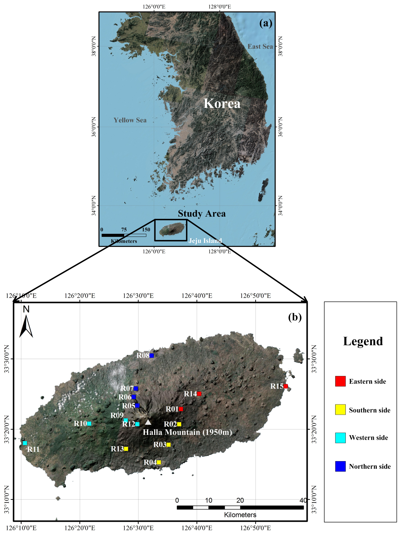
Figure 1Locations of the 15 precipitation sampling stations on Jeju Island, South Korea. (a) Regional setting of Jeju Island relative to the Korean Peninsula. (b) Distribution of the monitoring stations, grouped into northern, southern, eastern, and western sectors and spanning elevations of 5–1230 The location of Mt. Halla is also indicated.
Climatically, Jeju Island lies in a transitional zone between temperate continental and subtropical maritime regimes. Its climate is strongly shaped by monsoon circulation, seasonal shifts in moisture sources, and interactions between the Siberian High and the North Pacific High. Winters (November to April) are influenced by cold, dry continental air masses, while summers (June–September) are dominated by humid maritime tropical air advected from the Pacific Ocean. During the sampling period from September 2000 to December 2003, the site-specific mean monthly air temperatures associated with the isotope-monitoring network ranged from −3.4 to 27.9 °C, with an overall mean of 12.7 °C. Annual precipitation exceeds 1600 mm in most regions, with over half occurring during the summer monsoon period. These synoptic-scale seasonal contrasts contribute to seasonal changes in precipitation δ18O and δ2H values and d-excess, contributing to well-defined seasonal patterns in δ18O, δ2H, and d-excess values (Lee et al., 2013; KMA, 2021). The combined influence of steep altitudinal gradients, varied moisture source trajectories, and distinct monsoon circulation patterns produces spatial and temporal variations in precipitation δ18O, δ2H, and d-excess that cannot be captured using single-station monitoring approaches. Coastal regions are predominantly influenced by marine vapor and convective rainfall, while precipitation at higher elevations is generally depleted in 18O and 2H relative to precipitation at lower elevations. These conditions make Jeju Island an ideal setting for investigating altitude effects, moisture-source variability, and monsoon-driven isotopic seasonality through multi-site, long-term monitoring. Consequently, the 15 monitoring stations were distributed across elevations ranging from 5 to 1230 m a.s.l. to capture these spatial gradients.
2.2 Previous stable isotopic studies on Jeju Island
Previous studies on Jeju Island examined stable isotopes in precipitation, groundwater, and cave water, but the early precipitation records were generally limited in duration or spatial coverage (Lee et al., 1999, 2003; Woo et al., 2013). Recent work analyzed stable isotopes in monthly precipitation and groundwater together with isotope mixing to examine the seasonal and elevational origins of groundwater recharge, identifying high-elevation summer precipitation as the dominant recharge source (Kim et al., 2026a). The present data paper complements that application-focused study by documenting and openly publishing a station-resolved precipitation-isotope record and associated metadata from September 2000 to December 2003, facilitating transparent reuse and evaluation of seasonal and elevation-related patterns.
Subsequent research expanded to include the isotopic characterization of groundwater, cave dripwater, and speleothems, demonstrating that modern precipitation isotope data are essential for calibrating paleoclimate proxies in Jeju's volcanic landscapes (Woo et al., 2008; Jo et al., 2014). These studies identified that groundwater recharge is predominantly derived from high-elevation winter precipitation, while speleothem isotopic signals preserve a mixture of seasonal infiltration and moisture source variability (Lee et al., 2007; Kim et al., 2003). However, these investigations largely relied on extrapolated isotope lapse rates or interpolated GNIP data due to the absence of a spatially resolved precipitation isotope dataset collected simultaneously across multiple elevations and climatic regimes. This limitation has hindered the ability to accurately quantify spatial heterogeneity in isotopic elevation relationships, moisture source transitions, and monsoon driven fractionation processes, thereby constraining the development of reliable isoscapes and robust paleoclimate interpretations for Jeju Island (Peng et al., 2010; Ha et al., 2013).
More recent studies employed isotope-enabled models and atmospheric satellite observations to analyze moisture source trajectories and synoptic-scale vapor dynamics affecting Jeju Island (Yoshimura et al., 2011; Lee et al., 2013). These works highlighted the importance of a seasonal pattern characterized by lower precipitation δ18O and δ2H values in summer and higher values in winter, but validation of these model outputs was limited due to sparse in situ observations and the lack of a high-density monitoring network. The previous studies could therefore characterize either temporal changes or spatial differences, but not both concurrently. No prior study has produced a multi-year, multi-site dataset capturing both spatial and temporal variability of precipitation isotopes across volcanic terrain, which is essential for quantifying altitude effects, seasonal moisture source changes, monsoon circulation patterns, and Rayleigh distillation across elevation gradients.
Recent work on Jeju Island combined precipitation and groundwater isotope observations with mixing analysis to identify seasonal and high-elevation contributions to groundwater recharge (Kim et al., 2026a). The present data paper complements that application-focused study by openly providing the complete station-resolved precipitation isotope record and associated metadata, enabling independent reuse, consistent evaluation of isotope–elevation relationships, and comparison with subsequent monitoring. The present dataset fills this critical gap by providing simultaneous spatial and temporal precipitation isotope observations from 15 stations over a continuous 39-month period. It enables, for the first time on Jeju Island, quantitative assessment of both seasonal isotope cycles and decreases in precipitation δ18O and δ2H values with increasing elevation, facilitating more accurate characterization of recharge dynamics, topographic gradients, and paleoenvironmental interpretations. The dataset also offers a robust observational basis for calibrating isotope-enabled climate models and for developing regional isoscape frameworks.
2.3 Sampling and analytical methods
Precipitation samples were collected continuously from September 2000 to December 2003 at 15 strategically selected stations distributed across Jeju Island (5–1230 m a.s.l.), covering distinct topographic, climatic, and geographic features (Fig. 1). The sampling network was designed to represent windward and leeward slopes, coastal-to-inland transitions, and altitudinal gradients, allowing simultaneous characterization of spatial and temporal variations in precipitation δ18O, δ2H, and d-excess. Stations were classified into four elevation zones (coastal < 100 m, lowland 100–300 m, mid-elevation 300–800 m, and high-elevation > 800 m) to quantify altitude effects and orographic precipitation processes.
In total, δ18O and δ2H were measured in 462 precipitation samples, and d-excess was calculated as d = δ2H − 8 × δ18O. Analyses were conducted using an Isoprime isotope ratio mass spectrometer (IRMS) at the Korea Basic Science Institute (KBSI), following IAEA protocols. δ18O measurements were performed using CO2–H2O equilibration and cryogenic condensation, whereas δ2H was analyzed by chromium reduction (Cr-Pyrolysis) to generate H2 gas. Analytical precision was ± 1.0 ‰ for δ2H and ± 0.1 ‰ for δ18O, based on repeated internal standards calibrated against VSMOW2, SLAP2, and GISP reference waters. All reported values follow the conventional δ-notation relative to VSMOW:
where Rx is the ratio of heavy to light isotopes ( or ) in the sample.
During compilation of the released dataset, we did not apply a statistical outlier threshold to δ18O, δ2H, or d-excess. We retained the single exclusion reported by Lee et al. (2002). A May 2001 sample identified as ST-3 in that study had δ18O = −1.9 ‰ and δ2H = −33 ‰, with a d-excess value of −17.8 ‰. Lee et al. (2002) reported that the sample departed strongly from the meteoric-water-line relationship, interpreted this as evidence of substantial evaporation before analysis, and excluded it from their calculations. We therefore also excluded this sample from the released observations and from all analyses reported here. Its identifier, values, cross-reference, and exclusion rationale are retained in the Excluded_Samples worksheet for traceability. No additional archived measurement was removed during the present compilation solely because its δ18O, δ2H, or d-excess value was relatively high or low. The released dataset contains the remaining 462 paired δ18O and δ2H measurements. Site–month combinations without a valid archived isotope measurement remain missing and were neither reconstructed nor imputed. Precipitation and air-temperature records were not used as numerical isotope-screening criteria.
3.1 Temporal variations of precipitation isotopes
Precipitation δ18O and δ2H values and d-excess (d = δ2H − 8 × δ18O) varied seasonally during the 39-month observation period from September 2000 to December 2003 (Fig. 2). Monthly mean δ18O and δ2H values were generally lower during summer, particularly from June to September, and relatively higher during winter from November to February although the timing and magnitude varied among years. The seasonal minima in δ18O and δ2H broadly coincided with the main summer-monsoon precipitation period, whereas the seasonal maxima occurred during the relatively dry winter period. Across the 462 individual samples, δ18O ranged from −13.2 ‰ to −2.0 ‰, δ2H from −93.3 ‰ to −5.8 ‰, and d-excess from 3.3 ‰ to 29.1 ‰. The individual station-level δ18O observations are shown in Fig. S1 in the Supplement, and island-wide monthly means are shown with the corresponding meteorological series in Fig. 2. This pattern indicates that precipitation during the peak summer monsoon carries the most isotopically depleted signatures, reflecting intensified convective activity, long-distance moisture transport, and enhanced Rayleigh distillation associated with summer precipitation. In contrast, isotopic enrichment during winter precipitation is likely related to lower atmospheric humidity, stronger sub-cloud evaporation, and increased contributions from drier continental air masses during the cold season (Tao et al., 2025).
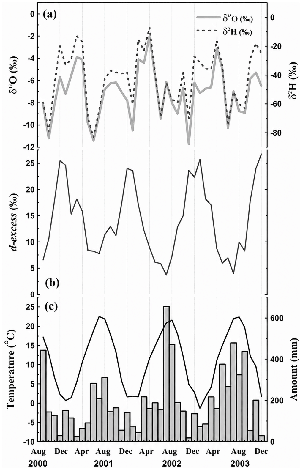
Figure 2Monthly variations in precipitation isotopes and associated meteorological conditions on Jeju Island, South Korea, from September 2000 to December 2003. (a) Precipitation δ18O and δ2H, (b) d-excess, and (c) mean air temperature (line) and precipitation amount (bars). Monthly values represent unweighted averages across stations with available data for each variable and observation month. Meteorological values are archived site-specific estimates derived from nearby Korea Meteorological Administration stations. The number of contributing stations varies among months and variables; missing observations were not imputed.
Unlike δ18O and δ2H, the secondary isotope parameter d-excess shows a more complex seasonal evolution, characterized by a quadratic rather than sinusoidal pattern, indicating a stronger sensitivity to kinetic fractionation processes (Dansgaard, 1964). Monthly d-excess values are lowest during summer months, consistent with highly humid maritime moisture sources, whereas significantly higher winter d-excess values are consistent with seasonal changes in source-region humidity and evaporation conditions; however, no unique moisture-source attribution is made from d-excess alone. These seasonal behaviors were further supported by correlation analysis, which showed that d-excess exhibited the strongest inverse relationship with air temperature (R2 = 0.77, p < 0.0001) compared to δ18O (R2 = 0.07) and δ2H (R2 = 0.29), confirming its higher sensitivity to moisture source humidity and evaporation conditions (Table 1). The broad seasonal cycle is consistent with changes in East Asian monsoon circulation, precipitation amount, transport history, and condensation along air-mass pathways (Lee et al., 2003, 2013). The present monthly dataset does not provide event-scale trajectories or process diagnostics, however, so individual samples are not assigned to specific moisture sources and the observed variations are not attributed to a single mechanism (Guo et al., 2021).
Table 1Correlations between isotopic compositions of precipitation and meteorological parameters.
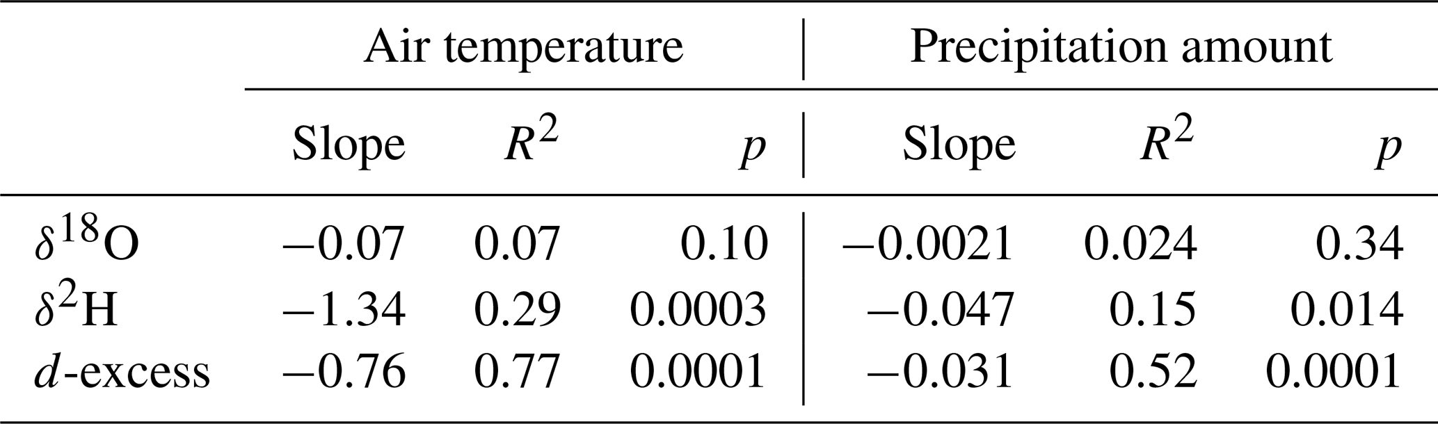
R2 and p denote the coefficient of determination and p-value, respectively.
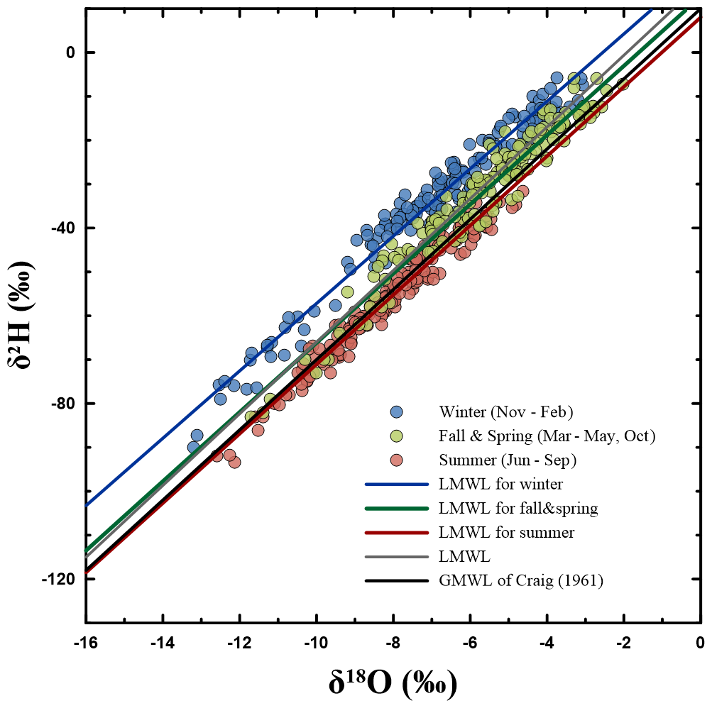
Figure 3Local meteoric water lines (LMWLs) for precipitation on Jeju Island, South Korea. Individual samples are grouped by observation month into summer (June–September; JJAS), winter (November–February; NDJF), and transitional months (March–May and October). Seasonal regression lines summarize the observed δ18O–δ2H relationships, with the global meteoric water line (GMWL; Craig, 1961) shown for reference.
Seasonal analysis of the local meteoric water lines (LMWLs) further reveals systematic variations in δ18O vs δ2H relationships associated with changes in atmospheric circulation and moisture source conditions over Jeju Island (Fig. 3; Table 2). The annual LMWL derived from the full dataset (δ2H = 8.17 × δ18O + 15.72, R2 = 0.89) reflects the integrated influence of both summer monsoon and winter precipitation regimes, but seasonal regressions demonstrate clear contrasts between warm and cold seasons (Fritz et al., 2022). During the summer monsoon period (JJAS), the LMWL exhibits a relatively higher slope and a markedly lower intercept, consistent with precipitation dominated by humid maritime moisture sources and extensive rainout under convective conditions, which suppresses kinetic fractionation during evaporation. In contrast, the winter LMWL (NDJF) is characterized by a reduced slope and an elevated intercept, indicating enhanced kinetic effects associated with lower humidity, stronger evaporation at the moisture source, and increased contributions from continental air masses transported over the Yellow Sea. Transitional seasons display intermediate LMWL characteristics, reflecting the gradual shift between these two dominant circulation regimes. These seasonal differences in LMWL geometry are consistent with the observed seasonal behavior of d-excess and corroborate the interpretation that moisture source humidity and atmospheric transport pathways exert a first-order control on isotope relationships in precipitation. The well-resolved seasonal LMWLs presented here provide a robust reference framework for interpreting groundwater recharge processes, cave dripwater isotopes, and paleoclimate archives in monsoon-influenced volcanic island environments, where mixing of seasonal signals can otherwise obscure the climatic interpretation of isotope records.
Table 2Summary of previous studies defining the local meteoric water line (LMWL).
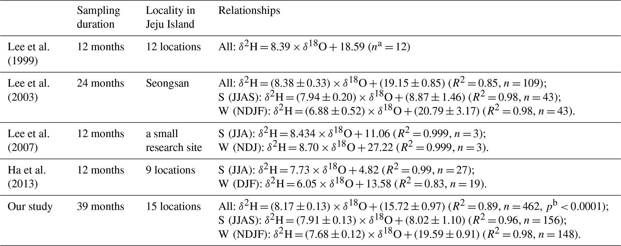
a: number of samples, b: probability
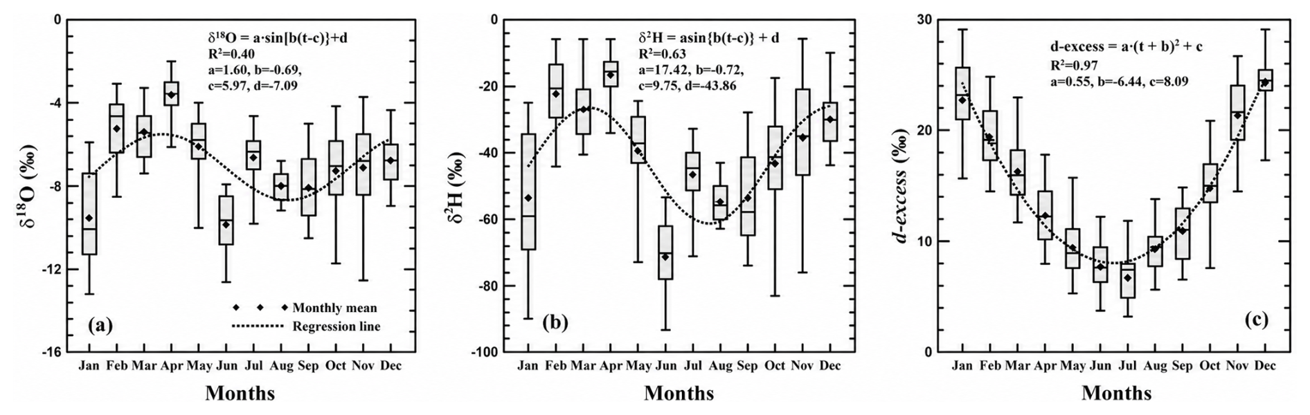
Figure 4Calendar-month variations in precipitation isotopes on Jeju Island, South Korea. Seasonal patterns in (a) δ18O and (b) δ2H are summarized using sinusoidal functions with a fixed 12-month period, while (c) d-excess is summarized using a quadratic function. The fitted curves provide empirical descriptions of seasonal variability during the observation period. Boxes span the 25th–75th percentiles, and whiskers indicate the minimum and maximum values.
Recurring annual variability in monthly δ18O and δ2H was summarized empirically as , where t is calendar month, C is the fitted baseline, A is amplitude, and φ is phase (Fig. 4). Unlike conventional raw isotopic time-series, the seasonal cycle parameters (baseline, amplitude, and phase) extracted from the periodic fitting approach allow direct input into hydrological and land-surface models that require temporally smoothed isotope forcing data (Nelson et al., 2021). This is particularly valuable in monsoon climates, where conventional amount-weighted averages do not capture seasonal variability in moisture source or atmospheric circulation. The documented seasonal cycle also defines a reference framework for distinguishing between temperature-based fractionation (winter isotopic enrichment) and moisture-source depletion (summer monsoon rainout), facilitating attribution of isotope variation to underlying atmospheric processes rather than simple temperature effects. The secondary isotopic parameter, d-excess, however, exhibited a more complex seasonal pattern, deviating from pure sinusoidal behavior. Its strong inverse relationship with temperature and relative humidity confirms that d-excess can serve as an effective indicator of moisture source humidity, ocean–atmosphere evaporation conditions, and sub-cloud kinetic fractionation during transport (Schoenemann and Steig, 2016). This sensitivity makes d-excess particularly valuable for identifying shifts between continental (high d-excess) and maritime (low d-excess) moisture sources, especially during winter and summer seasons, respectively. When integrated with satellite water vapor isotope datasets (e.g., TES, TROPOMI) or isotope-enabled reanalysis, the dataset can help improve representations of monsoon moisture recycling, boundary layer humidity, and airmass trajectory modeling (Worden et al., 2007; Lee et al., 2011; Lee et al., 2015). The fitted δ18O and δ2H baselines are −7.09 ‰ and −43.86 ‰, with amplitudes of 1.60 ‰ and 17.42 ‰, respectively. The corresponding R2 values are 0.40 and 0.63, respectively (Fig. 4). They are therefore descriptive summaries, not mechanistic representations of isotope processes or monthly climatological normals. d-excess was summarized with a quadratic calendar-month curve because its observed seasonal distribution was not symmetric. d-excess may be influenced by source-region humidity and evaporation, cloud processes, and sub-cloud exchange, among other factors. Low or high d-excess values are consequently not assigned here to a binary maritime-versus-continental source interpretation.
3.2 Spatial variations and isotope–elevation relationships
The spatial distribution of precipitation isotopes across Jeju Island demonstrates strong topographic control, primarily driven by orographic uplift, Rayleigh distillation, and varying exposure to maritime air masses. As shown in Fig. 5, δ18O and δ2H values exhibit progressive depletion with increasing elevation, forming a distinct altitudinal gradient characteristic of mountainous volcanic terrains. Based on 462 precipitation samples across 15 stations, δ18O decreased at an average rate of −1.5 ‰ per 1000 m, with a strong linear fit (R2 = 0.88, p < 0.005), while δ2H showed a corresponding trend of −11 ‰ per 1000 m (R2 = 0.77). These lapse rates are broadly consistent with those reported for other high-relief island environments in East Asia and the western Pacific, consistent with progressive rainout during orographic uplift.
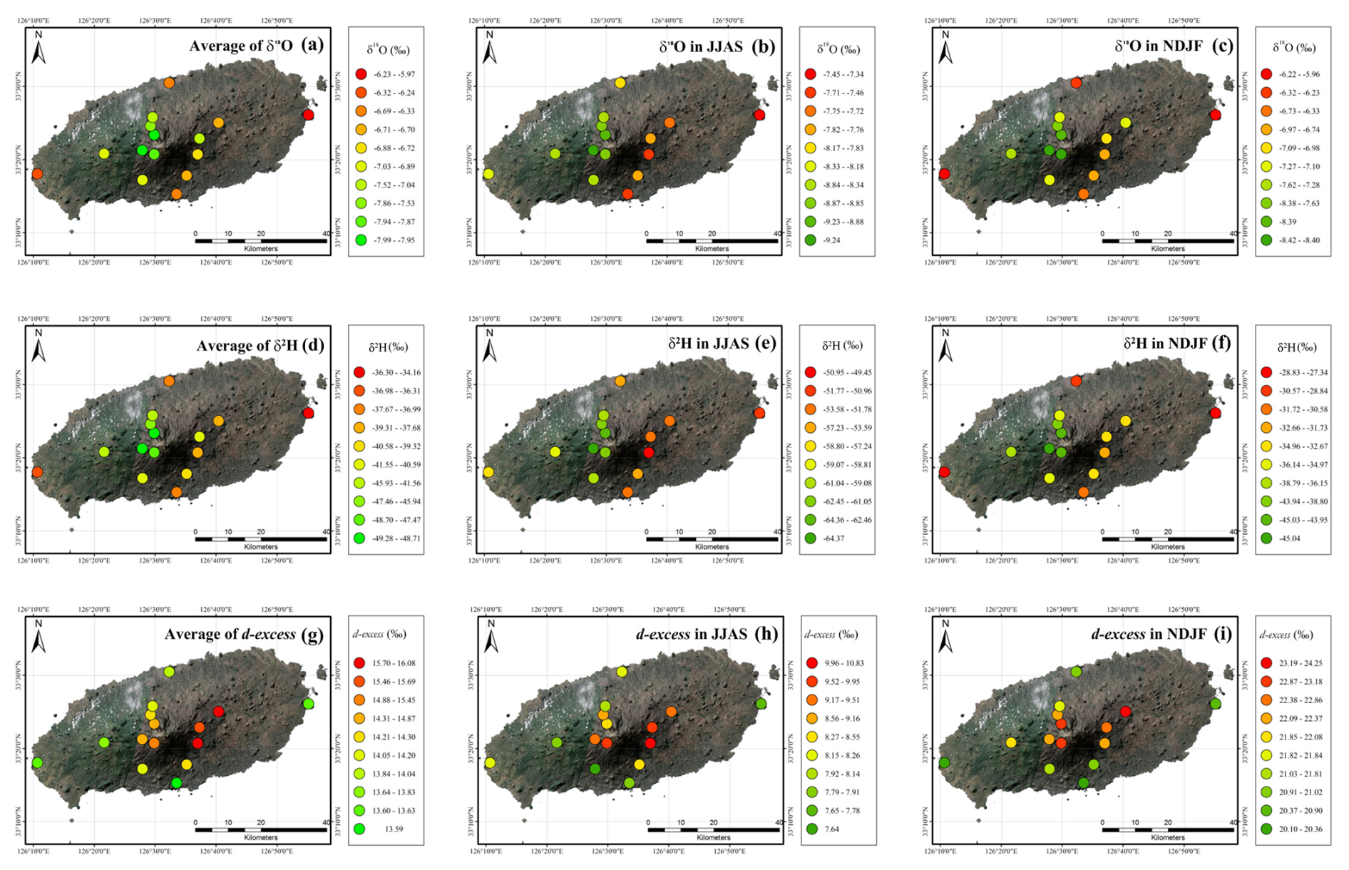
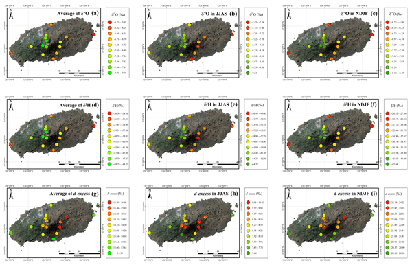
Figure 5Spatial distributions of station-mean precipitation δ18O (a–c), δ2H (d–f), and d-excess (g–i) on Jeju Island, South Korea. Columns show overall means (a, d, g), summer means (June–September; JJAS; b, e, h), and winter means (November–February; NDJF; c, f, i), calculated from available observations at each station. Symbols indicate monitoring locations, and colors represent the corresponding station-mean isotope values.
While δ18O and δ2H showed clear elevation-driven depletion trends, d-excess displayed weaker spatial dependence, with only modest changes across elevation groups (R2 = 0.39). Higher d-excess values at mid- and high-altitude locations indicate potential influence of drier continental air masses and moisture recycling during winter months, while lower values in coastal stations reflect more humid maritime moisture and stronger kinetic fractionation at the ocean–atmosphere interface. The combined analysis of δ18O, δ2H, and d-excess suggests that spatial variability in precipitation isotopes on Jeju Island is shaped not only by orographic lifting but also by seasonal shifts in moisture sources and varying humidity conditions during condensation and transport. The spatially resolved dataset presented here is the first to quantify the simultaneous effects of altitude, topographic orientation, and monsoon circulation on precipitation isotopes across Jeju Island. These results provide a robust observational basis for estimating groundwater recharge elevations, refining local isoscape models, and improving isotope-enabled hydrological simulations in volcanic island settings. Furthermore, the observed spatial gradients serve as critical calibration inputs for interpreting isotopic signals preserved in speleothems, cave dripwater, and other paleoclimate archives, contributing to improved proxy-based climate reconstructions in East Asia.
Table 3Linear regression equations of precipitation isotopes and altitude for each cardinal direction.

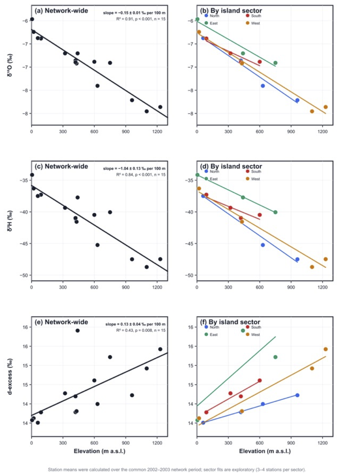
Figure 6Relationships between station elevation and precipitation δ18O (a, b), δ2H (c, d), and d-excess (e, f) on Jeju Island, South Korea. Values represent unweighted station means calculated from available observations over the common 2002–2003 period. Panels (a), (c), and (e) show all 15 station means and the network-wide linear regressions. Panels (b), (d), and (f) show separate regressions for the northern, southern, eastern, and western sectors. Reported gradient uncertainties are standard errors. Sector-specific regressions are exploratory because each sector contains only three or four stations; separate fits do not establish statistically significant differences among sector slopes.
To examine spatial heterogeneity, the monitoring stations were grouped into northern, southern, eastern, and western sectors (Fig. 6). To avoid confounding the comparisons with unequal station record lengths, station means were calculated over the common 2002–2003 network period. Across all 15 stations spanning 5–1230 , precipitation δ18O and δ2H values decreased significantly with elevation at rates of −0.146 ± 0.013 ‰ and −1.043 ± 0.128 ‰ per 100 m, respectively (δ18O: R2 = 0.913, p < 0.001; δ2H: R2 = 0.837, p < 0.001; Table 3). The sector-specific δ18O gradients ranged from −0.105 ‰ to −0.155 ‰ per 100 m, while the corresponding δ2H gradients ranged from −0.682 ‰ to −1.158 ‰ per 100 m. However, each sector comprised only three or four stations and covered a different elevation range. These sector-specific regressions should therefore be regarded as exploratory, and the separate fits do not demonstrate that the slopes differ significantly among sectors. Moreover, because sample-resolved wind and atmospheric-trajectory information is unavailable, the observed sector patterns cannot be attributed uniquely to marine influence, prevailing wind direction, topographic shielding, or windward–leeward position. The network-wide regressions provide the most robust first-order description of elevation-related variation in precipitation δ18O and δ2H during the common observation period (Wang et al., 2024b).
Examining altitudinal gradients along multiple cardinal directions provides further clarity on the spatial complexity of isotope fractionation across Jeju. This multidirectional perspective disentangles purely altitude-driven depletions from other spatial influences, such as the proximity to marine air masses or the prevailing wind trajectories. By constructing isotopic transects from north, south, east, and west, it becomes possible to pinpoint anisotropic depletion patterns and better discern localized controls on isotopic variability. These data, in turn, enhance the spatial resolution of isotope-based models and strengthen our capacity to predict recharge elevations and groundwater flow paths. The ability to distinguish between low-elevation recharge derived from coastal precipitation and high-elevation recharge sourced from more depleted rainfall is especially valuable for managing volcanic island aquifers, which often exhibit complex stratigraphy and vulnerability to contamination. Ultimately, integrating cardinal-direction transects with altitude effect analyses offers a comprehensive approach to understanding both the spatial and altitudinal dimensions of precipitation isotope variability, supporting improved water resource management and more nuanced paleoclimate reconstructions.
Previous satellite, IsoGSM, and 120 h HYSPLIT backward-trajectory analyses demonstrated seasonally contrasting atmospheric transport pathways over Jeju Island (Lee et al., 2013). These results provide regional atmospheric context for the possible influence of circulation on the directional lapse rates. However, because event-specific wind and trajectory information is not available for each monthly precipitation sample, the differences among the directional lapse rates cannot be attributed uniquely to particular airflow regimes. They are therefore interpreted as being consistent with combined differences in slope exposure, orographic ascent, and seasonal circulation rather than as direct evidence of a specific circulation mechanism.
Although precipitation isotope composition is affected by multiple atmospheric and meteorological processes, the observed isotope–elevation relationships provide a first-order empirical basis for developing a regional precipitation isoscape. The network-wide lapse rates can be used to estimate expected modern precipitation δ18O and δ2H values at elevations where direct observations are unavailable. The directional analyses additionally indicate whether separate relationships may be required for different slope sectors, although such subdivision should be applied only where supported by the regression results and station coverage. A regional precipitation isoscape would be particularly useful for cave and speleothem studies on Jeju Island because precipitation isotope composition is rarely measured directly at individual cave sites. Applying the observed isotope–elevation relationships to the elevation and geographical setting of a cave can provide an initial estimate of the modern precipitation isotope input to its recharge system. This estimate can help define the plausible precipitation end-member from which soil water, epikarst water, and cave dripwater are derived.
The estimated precipitation input does not directly calibrate a speleothem record because the transfer of an isotope signal from precipitation to speleothem calcite is additionally influenced by seasonal recharge weighting, evaporation, soil and epikarst storage, cave hydrology, water–rock interaction, and calcite precipitation processes. Nevertheless, the isoscape provides an important initial constraint for evaluating this transfer when direct precipitation isotope measurements at the cave elevation are unavailable.
3.3 Comparison with IsoGSM4 output and potential relevance to paleoclimate interpretation
The 39-month dataset across Jeju Island provides one of the few datasets in East Asia that captures both the amplitude and phase of seasonal isotopic cycles, allowing for robust quantification of seasonal offsets in δ18O, δ2H, and d-excess. Unlike short-duration event-based sampling campaigns or single-site monitoring records, this dataset enables assessment of multi-year seasonal stability, which is essential for calibrating isotope-enabled climate models, such as IsoGSM and iCESM, and for validating isotopic proxies preserved in groundwater and speleothem archives (Yoshimura et al., 2011; Brady et al., 2019). The consistent occurrence of isotopic minima during summer (June to September) and maxima during winter (November to February) supports its application in seasonal weighting of recharge, particularly in volcanic aquifers where infiltration timing determines groundwater residence and isotope signatures.
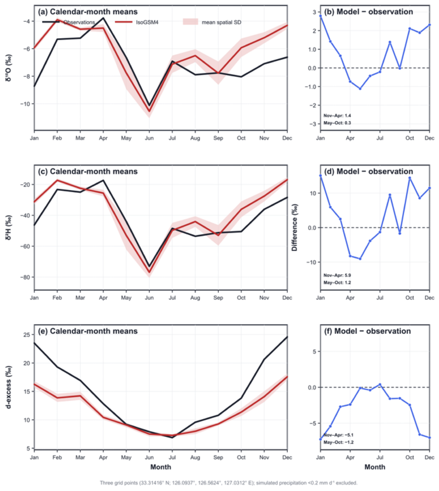
Figure 7Calendar-month comparison of precipitation-isotope observations and IsoGSM4 output for δ18O (a, b), δ2H (c, d), and d-excess (e, f). Left panels show calendar-month means derived from unweighted monthly averages of available station observations (black) and retained values from three neighboring IsoGSM4 grid points (red). Red shading denotes ± 1 standard deviation across the retained model grid points, representing spatial variability rather than model uncertainty. Right panels show IsoGSM4-minus-observation differences for each calendar month. Comparisons use matched observation months between September 2000 and December 2003. Model grid-point values with monthly mean precipitation below 0.2 mm d−1 were excluded before spatial averaging. The central grid point is located on Jeju Island, while the western and eastern points are offshore; their mean therefore represents an island–nearshore regional approximation.
To evaluate how well an isotope-enabled general circulation model reproduces the observed seasonal isotope variability over Jeju Island, we compared the observations with output from IsoGSM4 (IsoGSM-HR), the latest version of the isotope-incorporated Global Spectral Model, which simulates the fractionation and transport of stable water isotopes within a global atmospheric general circulation model (Yoshimura et al., 2008; Bong and Yoshimura, 2025a, b). The simulation was run at T248 spectral resolution, corresponding to a horizontal grid spacing of approximately 50 km, and was nudged to the ERA5 reanalysis so that the simulated synoptic-scale circulation follows the observed atmospheric evolution; this allows a direct, month-by-month comparison between the simulated and observed precipitation isotope compositions over the observation period (September 2000 to December 2003). Monthly mean precipitation δ18O and δ2H values were obtained from the published model output (Bong and Yoshimura, 2025a, b; https://doi.org/10.5281/zenodo.14681370 and https://doi.org/10.5281/zenodo.15073235). At this resolution, Jeju Island is covered by three model grid cells, centered at 33.31° N and 126.09° E, 126.56° E, and 127.03° E, corresponding to the western, central, and eastern parts of the island, respectively. Monthly values with simulated precipitation below 0.2 mm d−1 were excluded, because the isotopic composition of near-zero precipitation amounts is numerically unstable and not physically meaningful. For each month, the mean and standard deviation of δ18O, δ2H, and d-excess across the three grid cells were computed, and the ± 1 standard deviation range was used to construct the shaded band shown in Fig. 7, which is compared with the monthly mean observations averaged over all fifteen stations.
The mean model-minus-observation differences during May–October were +0.3 ‰ for δ18O, +1.2 ‰ for δ2H, and −1.2 ‰ for d-excess, whereas the corresponding differences during November–April were +1.4 ‰, +5.9 ‰, and −5.1 ‰, respectively (Fig. 7). The differences were therefore smaller during May–October than during November–April. However, the approximately 50 km grid cannot resolve Jeju Island's detailed topography, station-scale isotope–elevation relationships, or local-to-mesoscale precipitation processes. The comparison does not determine whether the seasonal differences arise from unresolved topography, land–sea contrasts, spatial representativeness, or parameterized cloud and precipitation processes. Resolving these contributions would require additional process diagnostics and an isotope-enabled convection-permitting regional model or an appropriately configured non-hydrostatic framework such as NICAM-WISO (Tanoue et al., 2023). The IsoGSM4 comparison is therefore used only to assess broad seasonal consistency and is not considered a validation of the observations or a process-attribution analysis.
During summer, particularly during the early-summer Changma season, precipitation over Jeju Island is strongly influenced by the Changma front, the Korean sector of the Meiyu–Baiu frontal system, and its associated large-scale moisture transport. Southwesterly flow along the western to northwestern flank of the western North Pacific subtropical high transports warm, moist air toward the Korean Peninsula, promoting moisture convergence and precipitation over Jeju Island and adjacent regions (Ninomiya and Akiyama, 1992; Lee et al., 2003; Kim et al., 2010).
When combined with independent cave-hydrological information, the dataset may also help assess how precipitation-isotope variability is transferred into cave dripwater. For example, comparisons between the precipitation record and contemporaneous or subsequent dripwater measurements may assist in evaluating whether a cave system integrates precipitation approximately across the year or preferentially reflects recharge during particular seasons. The observed range of precipitation δ18O values can provide an initial reference against which the magnitude and variability of dripwater δ18O are evaluated. Similarly, the elevation dependence of precipitation δ18O may help constrain the range of possible recharge elevations. These comparisons could support the development and testing of conceptual or numerical models describing the transfer of precipitation through soil, epikarst, and cave systems. They cannot, however, determine recharge seasonality or elevation without independent hydrological evidence.
The temporal coverage of the dataset imposes an additional limitation. The record extends for 39 months from September 2000 to December 2003 and can characterize spatial patterns and recurring seasonal variability during that interval. It is too short to quantify interannual-to-decadal variability, establish a long-term precipitation-isotope climatology, or determine whether the observed seasonal and elevation-related relationships remained stationary outside the monitoring period. The monthly samples may also integrate multiple precipitation events and atmospheric pathways, preventing event-specific moisture sources or transport histories from being identified. Moreover, the dataset does not include contemporaneous observations of cave dripwater, cave temperature, infiltration, or speleothem calcite. It therefore cannot provide a stand-alone calibration or validation of paleoclimate reconstructions.
The station-resolved precipitation isotope observations, calculated d-excess, meteorological records, metadata, and screening documentation are available in the released workbook through the Geo Big Data Open Platform at https://doi.org/10.22747/paper_data.20260219.42 (Lee et al., 2026). The IsoGSM4 (IsoGSM-HR) model output used for the model–observation comparison is openly available at https://doi.org/10.5281/zenodo.14681370 and https://doi.org/10.5281/zenodo.15073235 (Bong and Yoshimura, 2025a, b).
This study presents a spatially resolved dataset of stable water isotopes in precipitation collected across Jeju Island, South Korea. The dataset comprises 462 paired δ18O and δ2H measurements from 15 stations spanning elevations from 5 to 1230 during a 39-month monitoring period between September 2000 and December 2003. It also includes calculated d-excess values, meteorological observations, and station, sampling, analytical, and screening metadata. No statistical isotope-outlier threshold was applied; one previously documented sample affected by post-collection evaporation was excluded, and missing isotope observations were not imputed. The observations document both temporal and spatial variability in precipitation isotopes within a coordinated island-wide network. Monthly δ18O and δ2H values were generally lower during summer and higher during parts of the cool season. For station means over the common 2002–2003 network period, δ18O and δ2H decreased with elevation by −0.146 ± 0.013 ‰ and −1.043 ± 0.128 ‰ per 100 m, respectively, whereas d-excess increased by 0.126 ± 0.040 ‰ per 100 m. Sector-specific regressions are considered exploratory because each sector contains only three or four stations with different elevation ranges. The principal value of this dataset lies in its simultaneous coverage of seasonal variability and isotope–elevation relationships across Jeju Island's steep topographic gradient. Its recovery and open publication preserve historical observations that might otherwise remain inaccessible and provide a documented baseline for comparison with subsequent precipitation-isotope monitoring on Jeju Island. The IsoGSM4 comparison is retained only as a limited island-scale check on broad seasonal consistency. Although the 39-month record cannot characterize long-term climate variability or independently calibrate paleoclimate reconstructions, its spatial coverage, supporting metadata, and transparent documentation make it a useful resource for independent hydrological and isotope studies.
The supplement related to this article is available online at https://doi.org/10.5194/essd-18-7645-2026-supplement.
This study was conceptualized by KL and DK. Data were collected and analyzed by WP, YB, SK, HJ, CK and WS. The paper was written by YK and JL, with contributions from all authors.
The contact author has declared that none of the authors has any competing interests.
Publisher's note: Copernicus Publications remains neutral with regard to jurisdictional claims made in the text, published maps, institutional affiliations, or any other geographical representation in this paper. The authors bear the ultimate responsibility for providing appropriate place names. Views expressed in the text are those of the authors and do not necessarily reflect the views of the publisher.
The authors thank Kei Yoshimura and Hayoung Bong for sharing their model data.
This work was financially supported by a National Research Foundation of Korea (NRF2022R1A2C3007047) and partially supported by a grant (C638100) from the Korea Basic Science Institute. Additional support was partially provided by the Korea Environment Industry & Technology Institute through Aquatic Ecosystem Conservation Research Program, funded by the Korean Ministry of Environment (RS-2024-00332851) and the Basic Research Project (25-3411) of the Korea Institute of Geoscience and Mineral Resources (KIGAM), funded by the Ministry of Science and ICT.
This paper was edited by Attila Demény and reviewed by Alexandre Cauquoin and one anonymous referee.
Bong, H. and Yoshimura, K.: Enhancing the Representation of Atmospheric Water Isotopes with Higher-Resolution Global Modeling (IsoGSM4), Zenodo [data set], https://doi.org/10.5281/zenodo.14681370, 2025a.
Bong, H. and Yoshimura, K.: [IsoGSM-HR, monthly, 1970–2024, surface temperature, (water isotope) precipitation, and 2 m specific humidity] [CSV format]: Enhancing the Representation of Atmospheric Water Isotopes with Higher-Resolution Global Modeling, Zenodo [data set], https://doi.org/10.5281/zenodo.15073235, 2025b.
Brady, E., Stevenson, S., Bailey, D., Liu, Z., Noone, D., Nusbaumer, J., Otto-Bliesner, B. L., Tabor, C., Tomas, R., Wong, T., Zhang, J., and Zhu, J.: The Connected Isotopic Water Cycle in the Community Earth System Model Version 1, J. Adv. Model. Earth Sy., 11, 2547–2566, https://doi.org/10.1029/2019MS001663, 2019.
Craig, H.: Isotopic variations in meteoric waters, Science, 133, 1702–1703, https://doi.org/10.1126/science.133.3465.1702, 1961.
Dansgaard, W.: Stable isotopes in precipitation, Tellus, 16, 436–468, https://doi.org/10.1111/j.2153-3490.1964.tb00181.x, 1964.
Dee, S., Bailey, A., Conroy, J. L., Atwood, A., Stevenson, S., Nusbaumer, J., and Noone, D.: Water isotopes, climate variability, and the hydrological cycle: recent advances and new frontiers, Env. Res. Climate, 2, 022002, https://doi.org/10.1088/2752-5295/accbe1, 2023.
Feng, X., Faiia, A. M., and Posmentier, E. S.: Seasonality of isotopes in precipitation: A global perspective, J. Geophys. Res.-Atmos., 114, D08116, https://doi.org/10.1029/2008JD011279, 2009.
Fritz, M., Wetterich, S., McAlister, J., and Meyer, H.: A new local meteoric water line for Inuvik (NT, Canada), Earth Syst. Sci. Data, 14, 57–63, https://doi.org/10.5194/essd-14-57-2022, 2022.
Guan, H., Simmons, C. T., and Love, A. J.: Orographic controls on rain water isotope distribution in the Mount Lofty Ranges of South Australia, J. Hydrol., 374, 255–264, https://doi.org/10.1016/j.jhydrol.2009.06.018, 2009.
Guo, X., Gong, X., Shi, J., Guo, J., Domínguez-Villar, D., Lin, Y., Wang, H., and Yuan, D.: Temporal variations and evaporation control effect of the stable isotope composition of precipitation in the subtropical monsoon climate region, Southwest China, J. Hydrol., 599, 126278, https://doi.org/10.1016/j.jhydrol.2021.126278, 2021.
Ha, K., Yoon, Y. Y., Lee, K. Y., Cho, S. Y., and Ko, K. S.: Seasonal variation in the isotopic contents of precipitation in Korea, J. Radioanal. Nucl. Ch., 296, 389–395, https://doi.org/10.1007/s10967-012-2077-3, 2013.
Hahn, J., Lee, Y., Kim, N., Hahn, C., and Lee, S.: The groundwater resources and sustainable yield of Cheju volcanic island, Korea, Environ. Geol., 33, 43–53, https://doi.org/10.1007/s002540050223, 1997.
Hassanzadeh, A., Valdivielso, S., Vázquez-Suñé, E., Criollo, R., and Corbella, M.: An open source Python library for environmental isotopic modelling, Sci. Rep., 13, 1895, https://doi.org/10.1038/s41598-023-29073-2, 2023.
Jo, K.-N., Woo, K. S., Yi, S., Yang, D. Y., Lim, H. S., Wang, Y., Cheng, H., and Edwards, R. L.: Mid-latitude interhemispheric hydrologic seesaw over the past 550,000 years, Nature, 508, 378–382, https://doi.org/10.1038/nature13076, 2014.
Johnson, K. R. and Ingram, B. L.: Spatial and temporal variability in the stable isotope systematics of modern precipitation in China: implications for paleoclimate reconstructions, Earth Planet. Sc. Lett., 220, 365–377, https://doi.org/10.1016/S0012-821X(04)00036-6, 2004.
Jung, H., Ha, K., Koh, D.-C., Kim, Y., and Lee, J.: Statistical analysis relating variations in groundwater level to droughts on Jeju Island, Korea, Journal of Hydrology: Regional Studies, 36, 100879, https://doi.org/10.1016/j.ejrh.2021.100879, 2021.
Jung, H., Ahn, J., Iwahana, G., and Lee, J.: Understanding water flowpaths and origins in an Arctic Alaskan basin: Implications for permafrost hydrology under global warming, Advances in Climate Change Research, 16, 361–372, https://doi.org/10.1016/j.accre.2025.03.001, 2025.
Kim, K.-Y., Roh, J.-W., Lee, D.-K., and Jhun, J.-G.: Physical mechanisms of the seasonal, subseasonal, and high-frequency variability in the seasonal cycle of summer precipitation in Korea, J. Geophys. Res.-Atmos., 115, D14110, https://doi.org/10.1029/2009JD013561, 2010.
Kim, M.-C., Shin, W.-J., Koh, E.-H., Koh, C.-S., Kim, G.-E., and Lee, K.-S.: Stable isotope signatures of precipitation and implications for groundwater recharge on Jeju volcanic island, South Korea, Journal of Hydrology: Regional Studies, 64, 103141, https://doi.org/10.1016/j.ejrh.2026.103141, 2026a.
Kim, S., Han, Y., Hur, S. D., Yoshimura, K., and Lee, J.: Relating moisture transport to stable water vapor isotopic variations of ambient wintertime along the western coast of Korea, Atmosphere, 10, 806, https://doi.org/10.3390/atmos10120806, 2019.
Kim, S., Han, Y., Jung, H., and Lee, J.: Seasonal patterns and diagnostic values of δ2H, δ18O, d-excess, and δ17O in precipitation over Seoul, South Korea (2016–2020), Earth Syst. Sci. Data, 18, 1489–1501, https://doi.org/10.5194/essd-18-1489-2026, 2026b.
Kim, Y., Lee, K.-S., Koh, D.-C., Lee, D.-H., Lee, S.-G., Park, W.-B., Koh, G.-W., and Woo, N.-C.: Hydrogeochemical and isotopic evidence of groundwater salinization in a coastal aquifer: a case study in Jeju volcanic island, Korea, J. Hydrol., 270, 282–294, https://doi.org/10.1016/S0022-1694(02)00307-4, 2003.
Koh, D.-C., Ha, K., Lee, K.-S., Yoon, Y.-Y., and Ko, K.-S.: Flow paths and mixing properties of groundwater using hydrogeochemistry and environmental tracers in the southwestern area of Jeju volcanic island, J. Hydrol., 432–433, 61–74, https://doi.org/10.1016/j.jhydrol.2012.02.030, 2012.
Koh, E.-H., Lee, E., Lee, K.-K., and Moon, D.-C.: Integrated application of a Bayesian mixing model, numerical model, and environmental tracers to characterize groundwater recharge sources in a mountainous area, Sci. Total Environ., 853, 158619, https://doi.org/10.1016/j.scitotenv.2022.158619, 2022.
Konecky, B. L., McKay, N. P., Churakova (Sidorova), O. V., Comas-Bru, L., Dassié, E. P., DeLong, K. L., Falster, G. M., Fischer, M. J., Jones, M. D., Jonkers, L., Kaufman, D. S., Leduc, G., Managave, S. R., Martrat, B., Opel, T., Orsi, A. J., Partin, J. W., Sayani, H. R., Thomas, E. K., Thompson, D. M., Tyler, J. J., Abram, N. J., Atwood, A. R., Cartapanis, O., Conroy, J. L., Curran, M. A., Dee, S. G., Deininger, M., Divine, D. V., Kern, Z., Porter, T. J., Stevenson, S. L., von Gunten, L., and Iso2k Project Members: The Iso2k database: a global compilation of paleo-δ18O and δ2H records to aid understanding of Common Era climate, Earth Syst. Sci. Data, 12, 2261–2288, https://doi.org/10.5194/essd-12-2261-2020, 2020.
Korea Meteorological Administration (KMA): Meteorological observation data for Jeju station (hourly), Korea Meteorological Administration, https://data.kma.go.kr, last access: 29 September 2021.
Lee, J., Feng, X., Faiia, A. M., Posmentier, E. S., Kirchner, J. W., Osterhuber, R., and Taylor, S.: Isotopic evolution of a seasonal snowcover and its melt by isotopic exchange between liquid water and ice, Chem. Geol., 270, 126–134, https://doi.org/10.1016/j.chemgeo.2009.11.011, 2010.
Lee, J., Worden, J., Noone, D., Bowman, K., Eldering, A., LeGrande, A., Li, J.-L. F., Schmidt, G., and Sodemann, H.: Relating tropical ocean clouds to moist processes using water vapor isotope measurements, Atmos. Chem. Phys., 11, 741–752, https://doi.org/10.5194/acp-11-741-2011, 2011.
Lee, J., Worden, J., Koh, D.-C., Yoshimura, K., and Lee, J.-E.: A seasonality of δD of water vapor (850–500 hPa) observed from space over Jeju Island, Korea, Geosci. J., 17, 87–95, https://doi.org/10.1007/s12303-013-0003-5, 2013.
Lee, J., Worden, J., Noone, D., Chae, J. H., and Frankenberg, C.: Isotopic changes due to convective moistening of the lower troposphere associated with variations in the ENSO and IOD from 2005 to 2006, Tellus B, 67, 26177, https://doi.org/10.3402/tellusb.v67.26177, 2015.
Lee, K.-S., Koh, D.-C., Lee, D. H., and Park, W.-B.: The temporal and spacial distribution of stable isotope compositions of precipitation in Jeju Island: application to groundwater recharge study, Journal of the Geological Society of Korea, 38, 151–161, https://doi.org/10.14770/jgsk.2002.38.2.151, 2002.
Lee, K.-S., Grundstein, A. J., Wenner, D. B., Choi, M.-S., Woo, N.-C., and Lee, D.-H.: Climatic controls on the stable isotopic composition of precipitation in Northeast Asia, Clim. Res., 23, 137–148, https://doi.org/10.3354/cr023137, 2003.
Lee, K.-S., Kim, J.-M., Lee, D.-R., Kim, Y., and Lee, D.: Analysis of water movement through an unsaturated soil zone in Jeju Island, Korea using stable oxygen and hydrogen isotopes, J. Hydrol., 345, 199–211, https://doi.org/10.1016/j.jhydrol.2007.08.006, 2007.
Lee, K.-S., Koh, D.-C., Kim, Y.-H., Park, W.-B., Kim, S., Jung, H., Bong, Y.-S., Shin, W.-J., Kim, C., and Lee, J.: Water stable isotope data of precipitation in Jeju Island, Geo Big Data Open Platform [data set], https://doi.org/10.22747/paper_data.20260219.42, 2026.
Lee, S., Shimada, J., and Kayane, I.: Stable isotopes in precipitation in the volcanic island of Cheju, Korea, Hydrol. Process., 13, 113–121, https://doi.org/10.1002/(SICI)1099-1085(199901)13:1<113::AID-HYP698>3.0.CO;2-P, 1999.
Nelson, D. B., Basler, D., and Kahmen, A.: Precipitation isotope time series predictions from machine learning applied in Europe, P. Natl. Acad. Sci. USA, 118, e2024107118, https://doi.org/10.1073/pnas.2024107118, 2021.
Ninomiya, K. and Akiyama, T.: Multi-scale features of Baiu, the summer monsoon over Japan and the East Asia, J. Meteorol. Soc. Jpn., 70, 467–495, https://doi.org/10.2151/jmsj1965.70.1B_467, 1992.
Peng, T.-R., Wang, C.-H., Huang, C.-C., Fei, L.-Y., Chen, C.-T. A., and Hwong, J.-L.: Stable isotopic characteristic of Taiwan's precipitation: A case study of western Pacific monsoon region, Earth Planet. Sc. Lett., 289, 357–366, https://doi.org/10.1016/j.epsl.2009.11.024, 2010.
Posmentier, E. S., Feng, X., and Zhao, M.: Seasonal variations of precipitation δ18O in eastern Asia, J. Geophys. Res.-Atmos., 109, D23106, https://doi.org/10.1029/2004JD004510, 2004.
Prada, S., Cruz, J. V., and Figueira, C.: Using stable isotopes to characterize groundwater recharge sources in the volcanic island of Madeira, Portugal, J. Hydrol., 536, 409–425, https://doi.org/10.1016/j.jhydrol.2016.03.009, 2016.
Schoenemann, S. W. and Steig, E. J.: Seasonal and spatial variations of 17Oexcess and dexcess in Antarctic precipitation: Insights from an intermediate complexity isotope model, J. Geophys. Res.-Atmos., 121, 11215–11247, https://doi.org/10.1002/2016JD025117, 2016.
Tanoue, M., Yashiro, H., Takano, Y., Yoshimura, K., Kodama, C., and Satoh, M.: Modeling Water Isotopes Using a Global Non-Hydrostatic Model With an Explicit Convection: Comparison With Gridded Data Sets and Site Observations, J. Geophys. Res.-Atmos., 128, e2021JD036419, https://doi.org/10.1029/2021JD036419, 2023.
Tao, S., Xu, J., Xia, J., and Xiao, Y.: Influence of Sub-Cloud Evaporation on Precipitation Isotopes: Insights From Hourly-Scale Meteorological Assessment in a Large Lake in the East Asian Monsoon Region, Hydrol. Process., 39, e70152, https://doi.org/10.1002/hyp.70152, 2025.
Uemura, R., Masson-Delmotte, V., Jouzel, J., Landais, A., Motoyama, H., and Stenni, B.: Ranges of moisture-source temperature estimated from Antarctic ice cores stable isotope records over glacial–interglacial cycles, Clim. Past, 8, 1109–1125, https://doi.org/10.5194/cp-8-1109-2012, 2012.
Wang, S., Wang, L., Yang, G., Xiao, Y., Argiriou, A. A., Shi, Y., Lei, S., and Zhang, M.: Altitude effect of precipitation isotopes in an arid mountain-basin system: Observation and modelling around the world's second-largest shifting desert, J. Hydrol., 636, 131351, https://doi.org/10.1016/j.jhydrol.2024.131351, 2024a.
Wang, S., Wang, S., Huang, X., Wang, H., Han, Y., Wang, S., and Qi, S.: Groundwater composition and stable isotopes as proxies to investigate paleoclimate change in permafrost thawing regions, Appl. Geochem., 169, 106036, https://doi.org/10.1016/j.apgeochem.2024.106036, 2024b.
Woo, K. S., Kim, J. C., Choi, D. W., Kim, J. K., Kim, R., and Nehza, O.: The origin of erratic calcite speleothems in the Dangcheomul Cave (lava tube cave), Jeju Island, Korea, Quaternary Int., 176–177, 70–81, https://doi.org/10.1016/j.quaint.2007.05.009, 2008.
Woo, K. S., Jo, K.-N., Yi, S., Yang, D. Y., Li, H.-C., and Ji, H.: Paleoclimatic investigation using oxygen isotope compositions of the YC-1 stalagmite, Yeongcheon Cave, Jeju Island, Korea for the past 600 years, Journal of the Geological Society of Korea, 49, 339–350, https://doi.org/10.14770/jgsk.2013.49.3.339, 2013.
Worden, J., Noone, D., Bowman, K., and the Tropospheric Emission Spectrometer science team and data contributors: Importance of rain evaporation and continental convection in the tropical water cycle, Nature, 445, 528–532, https://doi.org/10.1038/nature05508, 2007.
Xie, C., Zhao, L., Eastoe, C. J., Liu, X., Wang, N., Zhang, Z., Dong, X., and Liu, H.: Precipitation stable isotope composition, moisture sources, and controlling factors in Xi'an, Northwest China, Atmos. Res., 280, 106428, https://doi.org/10.1016/j.atmosres.2022.106428, 2022.
Yoshimura, K., Kanamitsu, M., Noone, D., and Oki, T.: Historical isotope simulation using Reanalysis atmospheric data, J. Geophys. Res.-Atmos., 113, D19108, https://doi.org/10.1029/2008JD010074, 2008.
Yoshimura, K., Frankenberg, C., Lee, J., Kanamitsu, M., Worden, J., and Röckmann, T.: Comparison of an isotopic atmospheric general circulation model with new quasi-global satellite measurements of water vapor isotopologues, J. Geophys. Res.-Atmos., 116, D19118, https://doi.org/10.1029/2011JD016035, 2011.