Articles | Volume 18, issue 9
https://doi.org/10.5194/essd-18-6815-2026
© Author(s) 2026. This work is distributed under
the Creative Commons Attribution 4.0 License.
the Creative Commons Attribution 4.0 License.
https://doi.org/10.5194/essd-18-6815-2026
© Author(s) 2026. This work is distributed under
the Creative Commons Attribution 4.0 License.
the Creative Commons Attribution 4.0 License.
Data description article
| 
15 Sep 2026
Data description article |
| 15 Sep 2026
| 15 Sep 2026
OceanTACO: a multi-sensor global ocean sea surface state dataset

Data Science in Earth Observation, Technical University of Munich (TUM), 80333 Munich, Germany
Munich Center for Machine Learning (MCML), 80333 Munich, Germany
Cesar Aybar
Image Processing Lab (IPL), University of Valencia, 46980 Valencia, Spain
Ando Shah
School of Information, University of California, Berkeley, Berkeley, CA 94720, USA
Marcello Passaro
Deutsches Geodätisches Forschungsinstitut (DGFI-TUM), Technical University of Munich (TUM), 80333 Munich, Germany
Jonathan L. Bamber
CORRESPONDING AUTHOR
School of Geographical Sciences, University of Bristol, Bristol BS8 1SS, UK
Institute for Advanced Study, Technical University of Munich (TUM), 80333 Munich, Germany
Data Science in Earth Observation, Technical University of Munich (TUM), 80333 Munich, Germany
Munich Center for Machine Learning (MCML), 80333 Munich, Germany
Related authors
No articles found.
Bjorn Backeberg, Jemma Johnson, Natalia Aleksandrova, Cornelis Slobbe, Fabio Mangini, Marcello Passaro, Sanne Muis, Pavel Ditmar, Antonio Bonaduce, Gundula Winter, and Michael Hart-Davis
EGUsphere, https://doi.org/10.5194/egusphere-2026-3916, https://doi.org/10.5194/egusphere-2026-3916, 2026
This preprint is open for discussion and under review for Natural Hazards and Earth System Sciences (NHESS).
Short summary
Short summary
Coastal cities face growing flood risk from rising seas and storms. Scientists estimate dangerous water levels using satellite measurements of sea level and computer models of ocean behaviour, but the two are often combined inconsistently. We reviewed this research and found the real challenge is not merging the data, but making sure both methods measure the same thing, the same way. Solving this could lead to more reliable, consistent flood-risk estimates for coastal communities worldwide.
David Montero, César Aybar, Miguel D. Mahecha, and Luis Gómez-Chova
Int. Arch. Photogramm. Remote Sens. Spatial Inf. Sci., L-4-W1-2026, 167–174, https://doi.org/10.5194/isprs-archives-L-4-W1-2026-167-2026, https://doi.org/10.5194/isprs-archives-L-4-W1-2026-167-2026, 2026
Alejandro Blazquez, Benoit Meyssignac, Robin Fraudeau, Michael Ablain, Jonathan Bamber, Antonio Bonaduce, Marie Bouih, Anny Cazenave, Thorben Döhne, Ines Dussaillant, Ramiro Ferrari, Martin Horwath, Nicolas Kolodziejczyk, Hugo Lecomte, Stephanie Leroux, William Llovel, Daniele Melini, Erwan Oulhen, Thierry Penduff, Roshin P. Raj, Giorgio Spada, Marius Schlaak, Papasarafianou Stamatia, Andrea Storto, Chunxue Yang, and Sarah Connors
Earth Syst. Sci. Data Discuss., https://doi.org/10.5194/essd-2026-627, https://doi.org/10.5194/essd-2026-627, 2026
Preprint under review for ESSD
Short summary
Short summary
Closing the sea‑level budget on annual and longer time scales is a cornerstone of physical oceanography because sea‑level rise is one of the best indicators of climate change, and a closed budget shows we have identified and quantified all major drivers. We examined it from 1993 to 2022, finding an accelerated rise that matched ice melt and warm water until 2015. Afterwards an unexplained gap appears. Better deep‑ocean observations and refined gravity processing are needed to close the budget.
Marie-Christin Juhl, Marcello Passaro, Denise Dettmering, Michael G. Hart-Davis, and Martin Saraceno
EGUsphere, https://doi.org/10.5194/egusphere-2026-4751, https://doi.org/10.5194/egusphere-2026-4751, 2026
This preprint is open for discussion and under review for Ocean Science (OS).
Short summary
Short summary
Ocean fronts are boundaries where water masses meet, influencing how heat, nutrients, and marine life move across continental shelves. Satellites have long tracked these fronts using sea temperature and sea level, but in coastal waters, they remain difficult to resolve. We combine both signals to map fronts along the Patagonian continental shelf, showing that a new high-resolution satellite mission improves detection of coastal and seasonal fronts compared with conventional satellite data.
Xiaojun Ma, Matt King, Jonathan Bamber, Bin Liu, Wenke Sun, and Qiuyu Wang
EGUsphere, https://doi.org/10.5194/egusphere-2026-3461, https://doi.org/10.5194/egusphere-2026-3461, 2026
Short summary
Short summary
Satellite records of glacier change are only about two decades long, so short-term climate swings can strongly affect estimated trends. Using satellite gravity data, we show that the largest year-to-year changes in global glacier mass come from the Arctic and are linked to the North Atlantic Oscillation and Pacific Decadal Oscillation. Accounting for these effects makes Alaska’s estimated ice loss about one-third larger, improving interpretation of glacier change and future sea-level rise.
Leyue Tang, Jonathan L. Bamber, Tian Li, and Gang Qiao
Earth Syst. Sci. Data Discuss., https://doi.org/10.5194/essd-2026-414, https://doi.org/10.5194/essd-2026-414, 2026
Revised manuscript under review for ESSD
Short summary
Short summary
Many Antarctic ice shelves are thinning and retreating, threatening future sea-level rise. Surface damage indicates structural weakening, but long-term records are scarce. We created a multi-decadal surface damage record for nine representative Antarctic ice shelves using satellite imagery and deep learning. The dataset shows that Pine Island, Thwaites and Larsen B have experienced the most significant damage changes since 1999, providing valuable insights into ice shelf stability.
Viola Steidl, Jürgen Kusche, Fupeng Li, and Xiao Xiang Zhu
EGUsphere, https://doi.org/10.5194/egusphere-2026-2312, https://doi.org/10.5194/egusphere-2026-2312, 2026
Short summary
Short summary
Terrestrial water storage is an indicator of water availability, but forecasting its changes is difficult as it depends on processes acting at varying spatial and temporal scales. We introduce a hierarchical machine learning model that represents the Earth at two scales, the grid scale and the hydrological basin scale, to forecast global water storage changes up to six months ahead. We identify where model skill fades and which challenges to address to improve its forecasts.
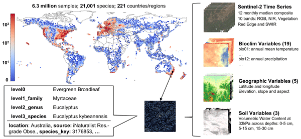
Yang Mu, Zhitong Xiong, Yi Wang, Muhammad Shahzad, Franz Essl, Holger Kreft, Mark van Kleunen, and Xiao Xiang Zhu
Earth Syst. Sci. Data, 18, 1379–1403, https://doi.org/10.5194/essd-18-1379-2026, https://doi.org/10.5194/essd-18-1379-2026, 2026
Short summary
Short summary
To better protect our planet's forests, we need to know what trees are where. We created GlobalGeoTree, a massive public dataset linking 6.3 million tree locations worldwide with satellite data. This dataset helps computers learn to identify tree species from space, supporting biodiversity monitoring and climate action. Our baseline model shows this is a promising path to understanding global forests.
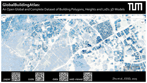
Xiao Xiang Zhu, Sining Chen, Fahong Zhang, Yilei Shi, and Yuanyuan Wang
Earth Syst. Sci. Data, 17, 6647–6668, https://doi.org/10.5194/essd-17-6647-2025, https://doi.org/10.5194/essd-17-6647-2025, 2025
Short summary
Short summary
We introduce GlobalBuildingAtlas, a publicly available dataset offering global and complete coverage of building polygons (GBA.Polygon), heights (GBA.Height) and Level of Detail 1 3D models (GBA.LoD1). This is the first open dataset to offer high quality, consistent, and complete building data in 2D and 3D at the individual building level on a global scale. With more than 2.75 billion buildings worldwide, it surpasses the most comprehensive database to date by more than 1 billion buildings.
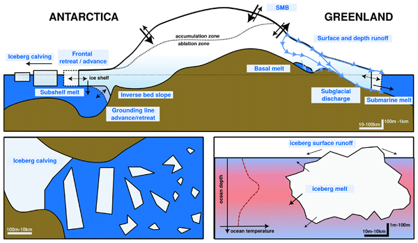
Gavin A. Schmidt, Kenneth D. Mankoff, Jonathan L. Bamber, Clara Burgard, Dustin Carroll, David M. Chandler, Violaine Coulon, Benjamin J. Davison, Matthew H. England, Paul R. Holland, Nicolas C. Jourdain, Qian Li, Juliana M. Marson, Pierre Mathiot, Clive R. McMahon, Twila A. Moon, Ruth Mottram, Sophie Nowicki, Anna Olivé Abelló, Andrew G. Pauling, Thomas Rackow, and Damien Ringeisen
Geosci. Model Dev., 18, 8333–8361, https://doi.org/10.5194/gmd-18-8333-2025, https://doi.org/10.5194/gmd-18-8333-2025, 2025
Short summary
Short summary
The impact of increasing mass loss from the Greenland and Antarctic ice sheets has not so far been included in historical climate model simulations. This paper describes the protocols and data available for modeling groups to add this anomalous freshwater to their ocean modules to better represent the impacts of these fluxes on ocean circulation, sea ice, salinity and sea level.
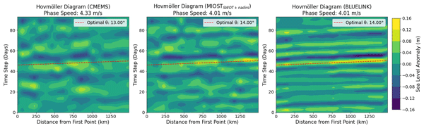
Marcello Passaro
Ocean Sci., 21, 2663–2679, https://doi.org/10.5194/os-21-2663-2025, https://doi.org/10.5194/os-21-2663-2025, 2025
Short summary
Short summary
This paper evaluates the capability of satellite altimetry to monitor coastally trapped waves in light of the latest advancements in daily gridded sea level data, including new interpolation schemes, an increased number of missions in orbit, and the incorporation of wide-swath altimetry measurements. The eastern Australian coast serves as a testbed, with validation provided by tide gauges and model data.
Adam Igneczi and Jonathan Louis Bamber
Earth Syst. Sci. Data, 17, 3203–3218, https://doi.org/10.5194/essd-17-3203-2025, https://doi.org/10.5194/essd-17-3203-2025, 2025
Short summary
Short summary
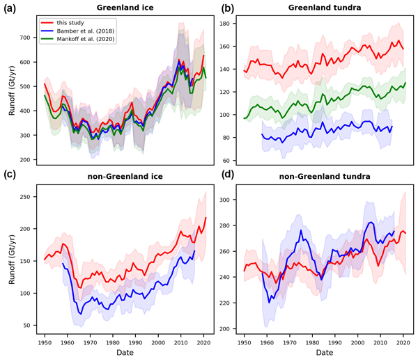
Freshwater from Arctic land ice loss strongly affects the Arctic and North Atlantic oceans. Datasets describing this freshwater discharge have low resolution and do not cover the entire Arctic. We statistically enhanced coarse-resolution climate model data – from approximately 6 km to 250 m – and routed meltwater towards the coastlines to provide high-resolution data covering all Arctic regions. This approach has far fewer computational requirements than running climate models at high resolution.
Zhenghang Yuan, Zhitong Xiong, Lichao Mou, and Xiao Xiang Zhu
Earth Syst. Sci. Data, 17, 1245–1263, https://doi.org/10.5194/essd-17-1245-2025, https://doi.org/10.5194/essd-17-1245-2025, 2025
Short summary
Short summary
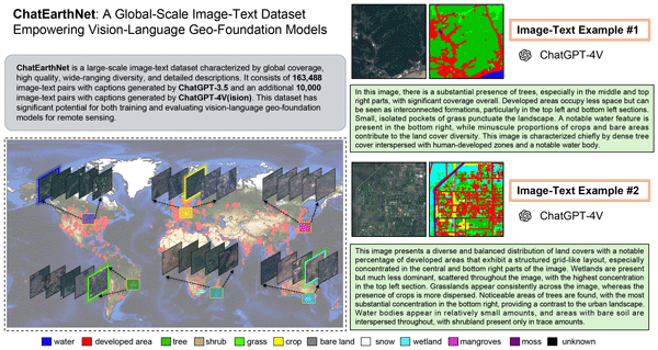
ChatEarthNet is an image–text dataset that provides high-quality, detailed natural language descriptions for global-scale satellite data. It consists of 163 488 image-text pairs with captions generated by ChatGPT-3.5 and an additional 10 000 image-text pairs with captions generated by ChatGPT-4V(ision). This dataset has significant potential for training and evaluating vision–language geo-foundation models in remote sensing.
Viola Steidl, Jonathan Louis Bamber, and Xiao Xiang Zhu
The Cryosphere, 19, 645–661, https://doi.org/10.5194/tc-19-645-2025, https://doi.org/10.5194/tc-19-645-2025, 2025
Short summary
Short summary
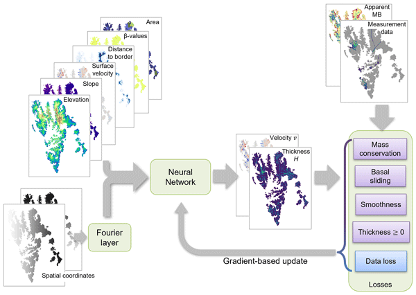
Glacier ice thickness is difficult to measure directly but is essential for glacier evolution modelling. In this work, we employ a novel approach combining physical knowledge and data-driven machine learning to estimate the ice thickness of multiple glaciers in Spitsbergen, Barentsøya, and Edgeøya in Svalbard. We identify challenges for the physics-aware machine learning model and opportunities for improving the accuracy and physical consistency that would also apply to other geophysical tasks.
Yifan Tian, Yao Sun, and Xiao Xiang Zhu
Abstr. Int. Cartogr. Assoc., 7, 171, https://doi.org/10.5194/ica-abs-7-171-2024, https://doi.org/10.5194/ica-abs-7-171-2024, 2024
Erik Loebel, Mirko Scheinert, Martin Horwath, Angelika Humbert, Julia Sohn, Konrad Heidler, Charlotte Liebezeit, and Xiao Xiang Zhu
The Cryosphere, 18, 3315–3332, https://doi.org/10.5194/tc-18-3315-2024, https://doi.org/10.5194/tc-18-3315-2024, 2024
Short summary
Short summary
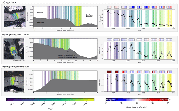
Comprehensive datasets of calving-front changes are essential for studying and modeling outlet glaciers. Current records are limited in temporal resolution due to manual delineation. We use deep learning to automatically delineate calving fronts for 23 glaciers in Greenland. Resulting time series resolve long-term, seasonal, and subseasonal patterns. We discuss the implications of our results and provide the cryosphere community with a data product and an implementation of our processing system.
David Montero, Miguel D. Mahecha, César Aybar, Clemens Mosig, and Sebastian Wieneke
Int. Arch. Photogramm. Remote Sens. Spatial Inf. Sci., XLVIII-4-W12-2024, 105–112, https://doi.org/10.5194/isprs-archives-XLVIII-4-W12-2024-105-2024, https://doi.org/10.5194/isprs-archives-XLVIII-4-W12-2024-105-2024, 2024
Weiyan Lin, Jiasong Zhu, Yuansheng Hua, Qingyu Li, Lichao Mou, and Xiao Xiang Zhu
Int. Arch. Photogramm. Remote Sens. Spatial Inf. Sci., XLVIII-1-2024, 371–378, https://doi.org/10.5194/isprs-archives-XLVIII-1-2024-371-2024, https://doi.org/10.5194/isprs-archives-XLVIII-1-2024-371-2024, 2024
Jérôme Benveniste, Salvatore Dinardo, Luciana Fenoglio-Marc, Christopher Buchhaupt, Michele Scagliola, Marcello Passaro, Karina Nielsen, Marco Restano, Américo Ambrózio, Giovanni Sabatino, Carla Orrù, and Beniamino Abis
Proc. IAHS, 385, 457–463, https://doi.org/10.5194/piahs-385-457-2024, https://doi.org/10.5194/piahs-385-457-2024, 2024
Short summary
Short summary
This paper presents the RDSAR, SAR/SARin & FF-SAR altimetry processors available in the ESA Altimetry Virtual Lab (AVL) hosted on the EarthConsole® platform. An overview on processors and features as well as preliminary analyses using AVL output data are reported to demonstrate the quality of the ESA Altimetry Virtual Lab altimetry services in providing innovative solutions to the radar altimetry community. https://earthconsole.eu//
Tian Li, Konrad Heidler, Lichao Mou, Ádám Ignéczi, Xiao Xiang Zhu, and Jonathan L. Bamber
Earth Syst. Sci. Data, 16, 919–939, https://doi.org/10.5194/essd-16-919-2024, https://doi.org/10.5194/essd-16-919-2024, 2024
Short summary
Short summary
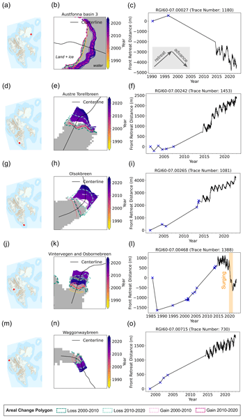
Our study uses deep learning to produce a new high-resolution calving front dataset for 149 marine-terminating glaciers in Svalbard from 1985 to 2023, containing 124 919 terminus traces. This dataset offers insights into understanding calving mechanisms and can help improve glacier frontal ablation estimates as a component of the integrated mass balance assessment.
Y. Sun, A. Kruspe, L. Meng, Y. Tian, E. J. Hoffmann, S. Auer, and X. X. Zhu
Int. Arch. Photogramm. Remote Sens. Spatial Inf. Sci., XLVIII-1-W2-2023, 225–232, https://doi.org/10.5194/isprs-archives-XLVIII-1-W2-2023-225-2023, https://doi.org/10.5194/isprs-archives-XLVIII-1-W2-2023-225-2023, 2023
J. Zhao, F. Roth, B. Bauer-Marschallinger, W. Wagner, M. Chini, and X. X. Zhu
ISPRS Ann. Photogramm. Remote Sens. Spatial Inf. Sci., X-1-W1-2023, 911–918, https://doi.org/10.5194/isprs-annals-X-1-W1-2023-911-2023, https://doi.org/10.5194/isprs-annals-X-1-W1-2023-911-2023, 2023
Yao Sun, Stefan Auer, Liqiu Meng, and Xiao Xiang Zhu
Abstr. Int. Cartogr. Assoc., 6, 250, https://doi.org/10.5194/ica-abs-6-250-2023, https://doi.org/10.5194/ica-abs-6-250-2023, 2023
Benoit S. Lecavalier, Lev Tarasov, Greg Balco, Perry Spector, Claus-Dieter Hillenbrand, Christo Buizert, Catherine Ritz, Marion Leduc-Leballeur, Robert Mulvaney, Pippa L. Whitehouse, Michael J. Bentley, and Jonathan Bamber
Earth Syst. Sci. Data, 15, 3573–3596, https://doi.org/10.5194/essd-15-3573-2023, https://doi.org/10.5194/essd-15-3573-2023, 2023
Short summary
Short summary
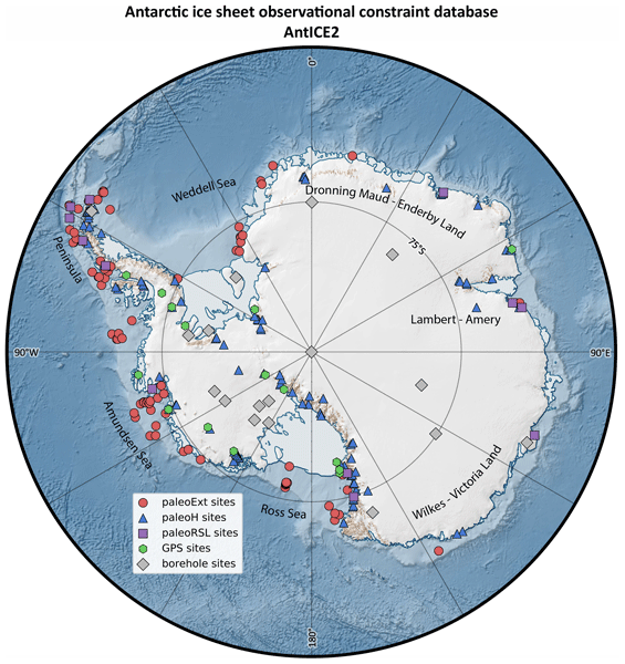
The Antarctic Ice Sheet Evolution constraint database version 2 (AntICE2) consists of a large variety of observations that constrain the evolution of the Antarctic Ice Sheet over the last glacial cycle. This includes observations of past ice sheet extent, past ice thickness, past relative sea level, borehole temperature profiles, and present-day bedrock displacement rates. The database is intended to improve our understanding of past Antarctic changes and for ice sheet model calibrations.
Alice C. Frémand, Peter Fretwell, Julien A. Bodart, Hamish D. Pritchard, Alan Aitken, Jonathan L. Bamber, Robin Bell, Cesidio Bianchi, Robert G. Bingham, Donald D. Blankenship, Gino Casassa, Ginny Catania, Knut Christianson, Howard Conway, Hugh F. J. Corr, Xiangbin Cui, Detlef Damaske, Volkmar Damm, Reinhard Drews, Graeme Eagles, Olaf Eisen, Hannes Eisermann, Fausto Ferraccioli, Elena Field, René Forsberg, Steven Franke, Shuji Fujita, Yonggyu Gim, Vikram Goel, Siva Prasad Gogineni, Jamin Greenbaum, Benjamin Hills, Richard C. A. Hindmarsh, Andrew O. Hoffman, Per Holmlund, Nicholas Holschuh, John W. Holt, Annika N. Horlings, Angelika Humbert, Robert W. Jacobel, Daniela Jansen, Adrian Jenkins, Wilfried Jokat, Tom Jordan, Edward King, Jack Kohler, William Krabill, Mette Kusk Gillespie, Kirsty Langley, Joohan Lee, German Leitchenkov, Carlton Leuschen, Bruce Luyendyk, Joseph MacGregor, Emma MacKie, Kenichi Matsuoka, Mathieu Morlighem, Jérémie Mouginot, Frank O. Nitsche, Yoshifumi Nogi, Ole A. Nost, John Paden, Frank Pattyn, Sergey V. Popov, Eric Rignot, David M. Rippin, Andrés Rivera, Jason Roberts, Neil Ross, Anotonia Ruppel, Dustin M. Schroeder, Martin J. Siegert, Andrew M. Smith, Daniel Steinhage, Michael Studinger, Bo Sun, Ignazio Tabacco, Kirsty Tinto, Stefano Urbini, David Vaughan, Brian C. Welch, Douglas S. Wilson, Duncan A. Young, and Achille Zirizzotti
Earth Syst. Sci. Data, 15, 2695–2710, https://doi.org/10.5194/essd-15-2695-2023, https://doi.org/10.5194/essd-15-2695-2023, 2023
Short summary
Short summary
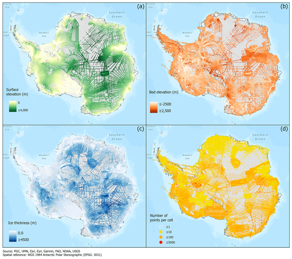
This paper presents the release of over 60 years of ice thickness, bed elevation, and surface elevation data acquired over Antarctica by the international community. These data are a crucial component of the Antarctic Bedmap initiative which aims to produce a new map and datasets of Antarctic ice thickness and bed topography for the international glaciology and geophysical community.
Tian Li, Geoffrey J. Dawson, Stephen J. Chuter, and Jonathan L. Bamber
The Cryosphere, 17, 1003–1022, https://doi.org/10.5194/tc-17-1003-2023, https://doi.org/10.5194/tc-17-1003-2023, 2023
Short summary
Short summary
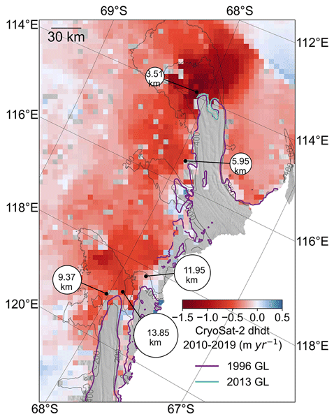
The Totten and Moscow University glaciers in East Antarctica have the potential to make a significant contribution to future sea-level rise. We used a combination of different satellite measurements to show that the grounding lines have been retreating along the fast-flowing ice streams across these two glaciers. We also found two tide-modulated ocean channels that might open new pathways for the warm ocean water to enter the ice shelf cavity.

Jingliang Hu, Rong Liu, Danfeng Hong, Andrés Camero, Jing Yao, Mathias Schneider, Franz Kurz, Karl Segl, and Xiao Xiang Zhu
Earth Syst. Sci. Data, 15, 113–131, https://doi.org/10.5194/essd-15-113-2023, https://doi.org/10.5194/essd-15-113-2023, 2023
Short summary
Short summary
Multimodal data fusion is an intuitive strategy to break the limitation of individual data in Earth observation. Here, we present a multimodal data set, named MDAS, consisting of synthetic aperture radar (SAR), multispectral, hyperspectral, digital surface model (DSM), and geographic information system (GIS) data for the city of Augsburg, Germany, along with baseline models for resolution enhancement, spectral unmixing, and land cover classification, three typical remote sensing applications.
Sam Royston, Rory J. Bingham, and Jonathan L. Bamber
Ocean Sci., 18, 1093–1107, https://doi.org/10.5194/os-18-1093-2022, https://doi.org/10.5194/os-18-1093-2022, 2022
Short summary
Short summary
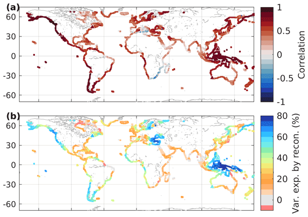
Decadal sea-level variability masks longer-term changes and increases uncertainty in observed trend and acceleration estimates. We use numerical ocean models to determine the magnitude of decadal variability we might expect in sea-level trends at coastal locations around the world, resulting from natural, internal variability. A proportion of that variability can be replicated from known climate modes, giving a range to add to short- to mid-term projections of regional sea-level trends.
S. Zhao, S. Saha, and X. X. Zhu
Int. Arch. Photogramm. Remote Sens. Spatial Inf. Sci., XLIII-B3-2022, 1407–1413, https://doi.org/10.5194/isprs-archives-XLIII-B3-2022-1407-2022, https://doi.org/10.5194/isprs-archives-XLIII-B3-2022-1407-2022, 2022
S. Saha, J. Gawlikowski, and X. X. Zhu
Int. Arch. Photogramm. Remote Sens. Spatial Inf. Sci., XLIII-B3-2022, 423–428, https://doi.org/10.5194/isprs-archives-XLIII-B3-2022-423-2022, https://doi.org/10.5194/isprs-archives-XLIII-B3-2022-423-2022, 2022
K. R. Traoré, A. Camero, and X. X. Zhu
ISPRS Ann. Photogramm. Remote Sens. Spatial Inf. Sci., V-3-2022, 217–224, https://doi.org/10.5194/isprs-annals-V-3-2022-217-2022, https://doi.org/10.5194/isprs-annals-V-3-2022-217-2022, 2022
T. Beker, H. Ansari, S. Montazeri, Q. Song, and X. X. Zhu
ISPRS Ann. Photogramm. Remote Sens. Spatial Inf. Sci., V-3-2022, 85–92, https://doi.org/10.5194/isprs-annals-V-3-2022-85-2022, https://doi.org/10.5194/isprs-annals-V-3-2022-85-2022, 2022
Stephen J. Chuter, Andrew Zammit-Mangion, Jonathan Rougier, Geoffrey Dawson, and Jonathan L. Bamber
The Cryosphere, 16, 1349–1367, https://doi.org/10.5194/tc-16-1349-2022, https://doi.org/10.5194/tc-16-1349-2022, 2022
Short summary
Short summary
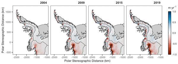
We find the Antarctic Peninsula to have a mean mass loss of 19 ± 1.1 Gt yr−1 over the 2003–2019 period, driven predominantly by changes in ice dynamic flow like due to changes in ocean forcing. This long-term record is crucial to ascertaining the region’s present-day contribution to sea level rise, with the understanding of driving processes enabling better future predictions. Our statistical approach enables us to estimate this previously poorly surveyed regions mass balance more accurately.
Tom Mitcham, G. Hilmar Gudmundsson, and Jonathan L. Bamber
The Cryosphere, 16, 883–901, https://doi.org/10.5194/tc-16-883-2022, https://doi.org/10.5194/tc-16-883-2022, 2022
Short summary
Short summary
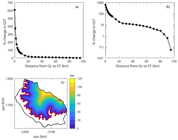
We modelled the response of the Larsen C Ice Shelf (LCIS) and its tributary glaciers to the calving of the A68 iceberg and validated our results with observations. We found that the impact was limited, confirming that mostly passive ice was calved. Through further calving experiments we quantified the total buttressing provided by the LCIS and found that over 80 % of the buttressing capacity is generated in the first 5 km of the ice shelf downstream of the grounding line.
Tian Li, Geoffrey J. Dawson, Stephen J. Chuter, and Jonathan L. Bamber
Earth Syst. Sci. Data, 14, 535–557, https://doi.org/10.5194/essd-14-535-2022, https://doi.org/10.5194/essd-14-535-2022, 2022
Short summary
Short summary
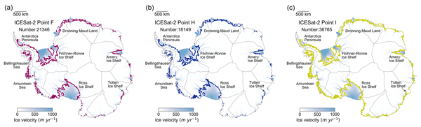
Accurate knowledge of the Antarctic grounding zone is important for mass balance calculation, ice sheet stability assessment, and ice sheet model projections. Here we present the first ICESat-2-derived high-resolution grounding zone product of the Antarctic Ice Sheet, including three important boundaries. This new data product will provide more comprehensive insights into ice sheet instability, which is valuable for both the cryosphere and sea level science communities.
Fanny Lehmann, Bramha Dutt Vishwakarma, and Jonathan Bamber
Hydrol. Earth Syst. Sci., 26, 35–54, https://doi.org/10.5194/hess-26-35-2022, https://doi.org/10.5194/hess-26-35-2022, 2022
Short summary
Short summary
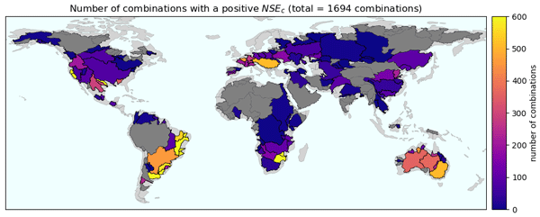
Many data sources are available to evaluate components of the water cycle (precipitation, evapotranspiration, runoff, and terrestrial water storage). Despite this variety, it remains unclear how different combinations of datasets satisfy the conservation of mass. We conducted the most comprehensive analysis of water budget closure on a global scale to date. Our results can serve as a basis to select appropriate datasets for regional hydrological studies.
Cited articles
Abdalla, S., Kolahchi, A. A., Ablain, M., Adusumilli, S., Bhowmick, S. A., Alou-Font, E., Amarouche, L., Andersen, O. B., Antich, H., Aouf, L., et al.: Altimetry for the future: Building on 25 years of progress, Adv. Space Res., 68, 319–363, https://doi.org/10.1016/j.asr.2021.01.022, 2021. a
Algarabel, G., Steventon, M., Munafò, M., and Ireland, M.: How reproducible and reliable is geophysical research? A review of the availability and accessibility of data and software for research published in journals, Seismica, 2, https://doi.org/10.26443/seismica.v2i1.278, 2023. a
Aouni, A. E., Gaudel, Q., Johnson, J. E., Charly, R., Sommer, J. L., van Gennip, S., Fablet, R., Drevillon, M., Drillet, Y., and Traon, P. Y. L.: OceanBench: A Benchmark for Data-Driven Global Ocean Forecasting systems, in: The Thirty-ninth Annual Conference on Neural Information Processing Systems Datasets and Benchmarks Track, https://openreview.net/forum?id=wZGe1Kqs8G (last access: 24 August 2026), 2025. a, b, c, d
Archambault, T., Filoche, A., Charantonis, A. A., and Béréziat, D.: Multimodal Unsupervised Spatio-Temporal Interpolation of satellite ocean altimetry maps, in: VISAPP, 159–167, https://doi.org/10.5220/0011620100003417, 2023. a, b
Archambault, T., Filoche, A., Charantonis, A., Béréziat, D., and Thiria, S.: Learning sea surface height interpolation from multi-variate simulated satellite observations, J. Adv. Model. Earth Sy., 16, e2023MS004047, https://doi.org/10.1029/2023ms004047, 2024. a
Archer, M., Wang, J., Klein, P., Dibarboure, G., and Fu, L.-L.: Wide-swath satellite altimetry unveils global submesoscale ocean dynamics, Nature, 640, 691–696, 2025. a
AVISO/DUACS: The SWOT L3 LR SSH product, derived from the L2 SWOT KaRIn low rate ocean data products (NASA/JPL and CNES), is produced and made freely available by AVISO and DUACS teams as part of the DESMOS Science Team project, AVISO/DUACS [data set], https://doi.org/10.24400/527896/A01-2023.017, 2024. a, b
Aybar, C., Contreras, J., Ma, C., Pellicer-Valero, O. J., Mateo-García, G., Gómez-Chova, L., Camps-Valls, G., Lehmann, N., Czerkawski, M., Montero, D., and Mahecha, M. D.: The Missing Piece: Standardising for AI-ready Earth Observation Datasets, in: TerraBytes-ICML 2025 workshop, https://openreview.net/forum?id=HV6F0dsGLK (last access: 24 August 2026), 2025. a, b, c
Ballarotta, M., Ubelmann, C., Pujol, M.-I., Taburet, G., Fournier, F., Legeais, J.-F., Faugère, Y., Delepoulle, A., Chelton, D., Dibarboure, G., and Picot, N.: On the resolutions of ocean altimetry maps, Ocean Sci., 15, 1091–1109, https://doi.org/10.5194/os-15-1091-2019, 2019. a, b, c
Ballarotta, M., Ubelmann, C., Bellemin-Laponnaz, V., Le Guillou, F., Meda, G., Anadon, C., Laloue, A., Delepoulle, A., Faugère, Y., Pujol, M.-I., Fablet, R., and Dibarboure, G.: Integrating wide-swath altimetry data into Level-4 multi-mission maps, Ocean Sci., 21, 63–80, https://doi.org/10.5194/os-21-63-2025, 2025. a
Beauchamp, M., Febvre, Q., Georgenthum, H., and Fablet, R.: 4DVarNet-SSH: end-to-end learning of variational interpolation schemes for nadir and wide-swath satellite altimetry, Geosci. Model Dev., 16, 2119–2147, https://doi.org/10.5194/gmd-16-2119-2023, 2023. a
Boutin, J., Vergely, J.-L., Marchand, S., d'Amico, F., Hasson, A., Kolodziejczyk, N., Reul, N., Reverdin, G., and Vialard, J.: New SMOS Sea Surface Salinity with reduced systematic errors and improved variability, Remote Sens. Environ., 214, 115–134, 2018. a
Buongiorno Nardelli, B., Droghei, R., and Santoleri, R.: Multi-dimensional interpolation of SMOS sea surface salinity with surface temperature and in situ salinity data, Remote Sens. Environ., 180, 392–402, https://doi.org/10.1016/j.rse.2015.12.052, 2016. a
Coca-Castro, A., Fouilloux, A., Barros Lourenço, R., McDonald, A., Rao, Y., and Hosking, J. S.: Improving the reproducibility in geoscientific papers: lessons learned from a Hackathon in climate science, Environ. Data Sci., 4, e6, https://doi.org/10.1017/eds.2024.35, 2025. a
Copernicus Marine Service: Global Ocean Along Track L3 Sea Surface Heights Reprocessed 1993 Ongoing Tailored For Data Assimilation, Marine Data Store (MDS) [data set], https://doi.org/10.48670/moi-00146, 2025a. a, b, c
Copernicus Marine Service: SMOS CATDS Qualified (L2Q) Sea Surface Salinity, https://doi.org/10.48670/mds-00368, 2025b. a, b
Copernicus Marine Service: Global Ocean Gridded L4 Sea Surface Heights and Derived Variables Reprocessed 1993 Ongoing, Copernicus Marine Service, Marine Data Store (MDS) [data set], https://doi.org/10.48670/moi-00148, 2025c. a
Copernicus Marine Service: Global Ocean Along Track L3 Sea Surface Heights NRT, Marine Data Store (MDS) [data set], https://doi.org/10.48670/moi-00153, 2025d. a, b
Copernicus Marine Service: Multi Observation Global Ocean Sea Surface Salinity and Sea Surface Density, Marine Data Store (MDS) [data set], https://doi.org/10.48670/moi-00150, 2025e. a, b
Copernicus Marine Service: Sea Surface Temperature Multi-sensor L3 Observations, Marine Data Store (MDS) [data set], https://doi.org/10.48670/moi-00151, 2025f. a, b
Copernicus Marine Service: Global Ocean Hourly Reprocessed Sea Surface Wind and Stress, Marine Data Store (MDS) [data set], https://doi.org/10.48670/moi-00152, 2025g. a, b
Droghei, R., Buongiorno Nardelli, B., and Santoleri, R.: Combining in-situ and satellite observations to retrieve salinity and density at the ocean surface, J. Atmos. Ocean. Tech., 33, 1211–1223, https://doi.org/10.1175/JTECH-D-15-0194.1, 2016. a
Droghei, R., Buongiorno Nardelli, B., and Santoleri, R.: A New Global Sea Surface Salinity and Density Dataset From Multivariate Observations (1993–2016), Front. Mar. Sci., 5, 84, https://doi.org/10.3389/fmars.2018.00084, 2018. a
Embury, O., Merchant, C. J., Good, S. A., Rayner, N. A., Høyer, J. L., Atkinson, C., Block, T., Alerskans, E., Pearson, K. J., Worsfold, M., McCarroll, N., and Donlon, C.: Satellite-based time-series of sea-surface temperature since 1980 for climate applications, Sci. Data, 11, 326, https://doi.org/10.1038/s41597-024-03147-w, 2024. a
Fanelli, C., Ciani, D., Pisano, A., and Buongiorno Nardelli, B.: Deep learning for the super resolution of Mediterranean sea surface temperature fields, Ocean Sci., 20, 1035–1050, https://doi.org/10.5194/os-20-1035-2024, 2024. a
Fouchet, E., Benkiran, M., Le Traon, P.-Y., and Remy, E.: Comparison of a global high-resolution ocean data assimilation system with SWOT observations, Front. Mar. Sci., 12, 1563934, https://doi.org/10.3389/fmars.2025.1563934, 2025. a
Fu, L.-L., Pavelsky, T., Cretaux, J.-F., Morrow, R., Farrar, J. T., Vaze, P., Sengenes, P., Vinogradova-Shiffer, N., Sylvestre-Baron, A., Picot, N., and Dibarboure, G.: The surface water and ocean topography mission: A breakthrough in radar remote sensing of the ocean and land surface water, Geophys. Res. Lett., 51, e2023GL107652, https://doi.org/10.1029/2023gl107652, 2024. a
Ji, T., Li, G., and Zhang, Y.: Observing storm surges in China's coastal areas by integrating multi-source satellite altimeters, Estuarine, Coast. Shelf S., 225, 106224, https://doi.org/10.1016/j.ecss.2019.05.006, 2019. a
Johnson, J. E., Febvre, Q., Gorbunova, A., Metref, S., Ballarotta, M., Le Sommer, J., and Fablet, R.: OceanBench: the sea surface height edition, Adv. Neural Inf., 36, 78275–78295, https://doi.org/10.52202/075280-3422, 2023. a, b, c
Klein, P., Lapeyre, G., Siegelman, L., Qiu, B., Fu, L.-L., Torres, H., Su, Z., Menemenlis, D., and Le Gentil, S.: Ocean-scale interactions from space, Earth Space Sci., 6, 795–817, 2019. a
Knapp, K. R., Kruk, M. C., Levinson, D. H., Diamond, H. J., and Neumann, C. J.: The international best track archive for climate stewardship (IBTrACS) unifying tropical cyclone data, B. Am. Meteorol. Soc., 91, 363–376, 2010. a
Krishna, D. and Sreejith, K.: Resolution of SWOT altimetry: Improvements along continental margins, Earth Space Sci., 12, e2025EA004312, https://doi.org/10.1029/2025ea004312, 2025. a
Le Guillou, F., Chapron, B., and Rio, M.-H.: VarDyn: Dynamical joint-reconstructions of sea surface height and temperature from multi-sensor satellite observations, J. Adv. Model. Earth Sy., 17, e2024MS004689, https://doi.org/10.1029/2024ms004689, 2025. a, b, c
Lehmann, N. and Aybar, C.: OceanTACO Extended, Hugging Face [code], https://doi.org/10.57967/hf/8172, 2026b. a, b, c
Lehmann, N. and Aybar, C.: OceanTACO, Hugging Face [code], https://doi.org/10.57967/hf/8171, 2026a. a, b, c
Lellouche, J.-M., Greiner, E., Bourdallé-Badie, R., Garric, G., Melet, A., Drévillon, M., Bricaud, C., Hamon, M., Le Galloudec, O., Regnier, C., Candela, T., Testut, C.-E., Gasparin, F., Ruggiero, G., Benkiran, M., Drillet, Y., and Le Traon, P.-Y.: The Copernicus global 1/12 oceanic and sea ice GLORYS12 reanalysis, Front. Earth Sci., 9, 698876, https://doi.org/10.3389/feart.2021.698876, 2021. a, b, c
Le Traon, P.-Y., Dibarboure, G., Lellouche, J.-M., Pujol, M.-I., Benkiran, M., Drevillon, M., Drillet, Y., Faugère, Y., and Remy, E.: Satellite altimetry and operational oceanography: from Jason-1 to SWOT, Ocean Sci., 21, 1329–1347, https://doi.org/10.5194/os-21-1329-2025, 2025. a
Li, J.-L. F., Tsai, Y.-C., Xu, K.-M., Lee, W.-L., Jiang, J. H., Yu, J.-Y., Fetzer, E. J., and Stephens, G.: Inferring the linkage of sea surface height anomalies, surface wind stress and sea surface temperature with the falling ice radiative effects using satellite data and global climate models, Environ. Res. Commun., 4, 125004, https://doi.org/10.1088/2515-7620/aca3fe, 2022. a
Li, X., Han, G., Yang, J., Chen, D., Zheng, G., and Chen, N.: Using satellite altimetry to calibrate the simulation of typhoon Seth storm surge off Southeast China, Remote Sens., 10, 657, https://doi.org/10.3390/rs10040657, 2018. a
Liang, Z., Bao, S., Zhang, W., Yan, H., Duan, B., and Wang, H.: Super-resolution reconstruction of SMOS sea surface salinity from multivariate satellite observations based on deep learning, IEEE J. Select. Top. Appl. Earth, 18, 24251–24266, https://doi.org/10.1109/jstars.2025.3602684, 2025. a
Llovel, W. and Lee, T.: Importance and origin of halosteric contribution to sea level change in the southeast Indian Ocean during 2005–2013, Geophys. Res. Lett., 42, 1148–1157, 2015. a
Martin, S. A., Manucharyan, G. E., and Klein, P.: Synthesizing sea surface temperature and satellite altimetry observations using deep learning improves the accuracy and resolution of gridded sea surface height anomalies, J. Adv. Model. Earth Sy., 15, e2022MS003589, https://doi.org/10.1029/2022ms003589, 2023. a, b, c
Martin, S. A., Manucharyan, G. E., and Klein, P.: Generative data assimilation for surface ocean state estimation from multi-modal satellite observations, J. Adv. Model. Earth Sy., 17, e2025MS005063, https://doi.org/10.1029/2025ms005063, 2025. a, b, c, d
Maze, G. and Balem, K.: argopy: A Python library for Argo ocean data analysis, J. Open Source Softw., 5, https://doi.org/10.21105/joss.02425, 2020. a
Mercator Ocean/Copernicus Marine Service: Copernicus Marine Toolbox (CLI & Python) [software], version 2.2.3; licensed under EUPL-1.2., https://github.com/mercator-ocean/copernicus-marine-toolbox (last access: 24 August 2026), 2025. a
Met Office: Global Ocean OSTIA Sea Surface Temperature and Sea Ice Reprocessed, Marine Data Store (MDS) [data set], https://doi.org/10.48670/moi-00168, 2025. a, b
Morrow, R., Fu, L.-L., Ardhuin, F., Benkiran, M., Chapron, B., Cosme, E., d'Ovidio, F., Farrar, J. T., Gille, S. T., Lapeyre, G., Le Traon, P.-Y., Pascual, A., Ponte, A., Qiu, B., Rascle, N., Ubelmann, C., Wang, J., and Zaron, E. D.: Global observations of fine-scale ocean surface topography with the surface water and ocean topography (SWOT) mission, Front. Mar. Sci., 6, 232, https://doi.org/10.3389/fmars.2019.00232, 2019. a, b
Paszke, A., Gross, S., Massa, F., Lerer, A., Bradbury, J., Chanan, G., Killeen, T., Lin, Z., Gimelshein, N., Antiga, L., Desmaison, A., Köpf, A., Yang, E., DeVito, Z., Raison, M., Tejani, A., Chilamkurthy, S., Steiner, B., Fang, L., Bai, J., and Chintala, S.: Pytorch: An imperative style, high-performance deep learning library, Adv. Neur. Inf., 32, https://doi.org/10.48550/arXiv.1912.01703, 2019. a
Perez, F. and Granger, B. E.: Project Jupyter: Computational narratives as the engine of collaborative data science, UC Berkeley and Cal Poly, http://archive.ipython.org/JupyterGrantNarrative-2015.pdf (last access: 24 August 2026), 2015. a
Smith, A. B.: US Billion-dollar weather and climate disasters, 1980–present, https://www.ncei.noaa.gov/access/billions/ (last access: 24 August 2026), 2025. a
Srinivasan, M. and Tsontos, V.: Satellite altimetry for ocean and coastal applications: A review, Remote Sens., 15, 3939, https://doi.org/10.3390/rs15163939, 2023. a
Taburet, G., Sanchez-Roman, A., Ballarotta, M., Pujol, M.-I., Legeais, J.-F., Fournier, F., Faugere, Y., and Dibarboure, G.: DUACS DT2018: 25 years of reprocessed sea level altimetry products, Ocean Sci., 15, 1207–1224, https://doi.org/10.5194/os-15-1207-2019, 2019. a, b, c, d
Vega-Gimenez, D., Amores, A., Paris, A., and Pascual, A.: Expanding the coastal observation frontier: SWOT reveals the spatial footprint of storm surges, Geophys. Res. Lett., 52, e2025GL117299, https://doi.org/10.1029/2025gl117299, 2025. a, b
Wang, Y., Zhang, S., and Jia, Y.: Enhanced resolution capability of SWOT sea surface height measurements and their application in monitoring ocean dynamics variability, Ocean Sci., 21, 931–944, https://doi.org/10.5194/os-21-931-2025, 2025. a
Wilkinson, M. D., Dumontier, M., Aalbersberg, I. J., Appleton, G., Axton, M., Baak, A., Blomberg, N., Boiten, J.-W., da Silva Santos, L. B., Bourne, P. E., et al.: The FAIR Guiding Principles for scientific data management and stewardship, Sci. Data, 3, 1–9, https://doi.org/10.1038/sdata.2016.18, 2016. a
Wong, A. P. S., Wijffels, S. E., Riser, S. C., et al.: Argo Data 1999–2019: Two Million Temperature-Salinity Profiles and Subsurface Velocity Observations From a Global Array of Profiling Floats, Front. Mar. Sci., 7, 700, https://doi.org/10.3389/fmars.2020.00700, 2020. a, b, c
Zhao, E., Goh, E., Yepremyan, A., Wang, J., and Wilson, B.: Multi-satellite U-Net for high-resolution sea surface temperature reconstruction, EGUsphere [preprint], https://doi.org/10.5194/egusphere-2025-4847, 2025. a
Zou, R., Wei, L., and Guan, L.: Super resolution of satellite-derived sea surface temperature using a transformer-based model, Remote Sens., 15, 5376, https://doi.org/10.3390/rs15225376, 2023. a
Short summary
Different satellites, ocean floats and model reanalysis products record sea surface height, temperature, salt content and winds, but each archive stores its data differently, so combining them is tedious and time consuming. We therefore combine these data sources into a consistent collection, so that data retrieval across sources becomes easier. Ocean studies are consequently easier to reproduce and compare, and hopefully support research and better understanding of ocean and climate processes.
Different satellites, ocean floats and model reanalysis products record sea surface height,...


Altmetrics
Final-revised paper
Preprint