Articles | Volume 18, issue 7
https://doi.org/10.5194/essd-18-5027-2026
© Author(s) 2026. This work is distributed under
the Creative Commons Attribution 4.0 License.
https://doi.org/10.5194/essd-18-5027-2026
© Author(s) 2026. This work is distributed under
the Creative Commons Attribution 4.0 License.
The DTU25 mean sea surface: from and for SWOT

DTU Space, Technical University of Denmark, Kongens Lyngby, Denmark
Ole Baltazar Andersen
DTU Space, Technical University of Denmark, Kongens Lyngby, Denmark
Per Knudsen
DTU Space, Technical University of Denmark, Kongens Lyngby, Denmark
Related authors
No articles found.
Christian Solgaard, Finn Bo Madsen, Malte Winther-Dahl, Thomas Henry Nylen, Danjal Longfors Berg, Ole Bjerregaard, Javed Hassan, Per Knudsen, Michael Bevis, and Shfaqat Abbas Khan
Earth Syst. Sci. Data, 18, 5117–5142, https://doi.org/10.5194/essd-18-5117-2026, https://doi.org/10.5194/essd-18-5117-2026, 2026
Short summary
Short summary
The Greenland GNSS (Global Navigation Satellite Systems) Network consists of more than 70 high-grade GNSS stations placed along the perimeter of Greenland. With this work, we present the processed position solutions for the 20+ year record in a daily resolution. Along with the processed time series, we also publish the extensive metadata record for the network and raw data. A comparison with other subsets of the data showed an increased stability in the full processed dataset we publish here.
Michael G. Hart-Davis, Roman Sulzbach, Stefan A. Talke, Ivan D. Haigh, Marta Marcos, Philip Woodworth, Richard Ray, Ole B. Andersen, Florent Lyard, Ergane Fouchet, Denise Dettmering, Maik Thomas, and Florian Seitz
Ocean Sci., 22, 1681–1709, https://doi.org/10.5194/os-22-1681-2026, https://doi.org/10.5194/os-22-1681-2026, 2026
Short summary
Short summary
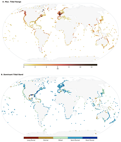
Ocean tides are a critical component of the global climate system, influencing a wide range of geophysical processes. Tide gauges have been a valuable source for developing the theory of ocean tides and for understanding their variability. We provide updated and new insights on tidal properties using the Global Extreme Sea Level Analysis tide gauge dataset, intended to be useful to a range of applications, from navigation and fishing communities to ocean scientists and tidal experts.
Yihao Wu, Hongkai Shi, Dongzhen Jia, Ole Baltazar Andersen, Xiufeng He, Zhicai Luo, Yu Li, Shiyuan Chen, Xiaohuan Si, Sisu Diao, Yihuang Shi, and Yanglin Chen
Earth Syst. Sci. Data, 17, 2463–2488, https://doi.org/10.5194/essd-17-2463-2025, https://doi.org/10.5194/essd-17-2463-2025, 2025
Short summary
Short summary
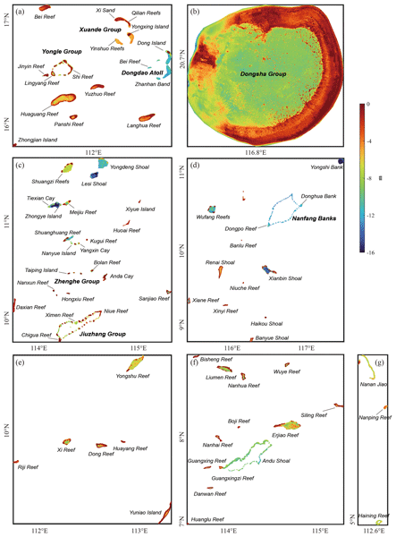
We developed a high-quality and cost-effective shallow-water depth model for >120 islands in the South China Sea, using ICESat-2 and Sentinel-2 satellite data. This model maps water depths with an accuracy of ~1 m. Our findings highlight the limitations of existing global bathymetry models in shallow regions. Our model exhibited superior performance in capturing fine-scale bathymetric features with unprecedented spatial resolution, providing essential data for marine applications.
Ole Baltazar Andersen, Stine Kildegaard Rose, Adili Abulaitijiang, Shengjun Zhang, and Sara Fleury
Earth Syst. Sci. Data, 15, 4065–4075, https://doi.org/10.5194/essd-15-4065-2023, https://doi.org/10.5194/essd-15-4065-2023, 2023
Short summary
Short summary
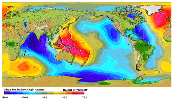
The mean sea surface (MSS) is an important reference for mapping sea-level changes across the global oceans. It is widely used by space agencies in the definition of sea-level anomalies as mapped by satellite altimetry from space. Here a new fully global high-resolution mean sea surface called DTU21MSS is presented, and a suite of evaluations are performed to demonstrate its performance.
Martin Horwath, Benjamin D. Gutknecht, Anny Cazenave, Hindumathi Kulaiappan Palanisamy, Florence Marti, Ben Marzeion, Frank Paul, Raymond Le Bris, Anna E. Hogg, Inès Otosaka, Andrew Shepherd, Petra Döll, Denise Cáceres, Hannes Müller Schmied, Johnny A. Johannessen, Jan Even Øie Nilsen, Roshin P. Raj, René Forsberg, Louise Sandberg Sørensen, Valentina R. Barletta, Sebastian B. Simonsen, Per Knudsen, Ole Baltazar Andersen, Heidi Ranndal, Stine K. Rose, Christopher J. Merchant, Claire R. Macintosh, Karina von Schuckmann, Kristin Novotny, Andreas Groh, Marco Restano, and Jérôme Benveniste
Earth Syst. Sci. Data, 14, 411–447, https://doi.org/10.5194/essd-14-411-2022, https://doi.org/10.5194/essd-14-411-2022, 2022
Short summary
Short summary
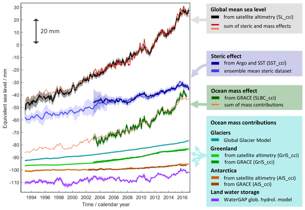
Global mean sea-level change observed from 1993 to 2016 (mean rate of 3.05 mm yr−1) matches the combined effect of changes in water density (thermal expansion) and ocean mass. Ocean-mass change has been assessed through the contributions from glaciers, ice sheets, and land water storage or directly from satellite data since 2003. Our budget assessments of linear trends and monthly anomalies utilise new datasets and uncertainty characterisations developed within ESA's Climate Change Initiative.
Carsten Bjerre Ludwigsen, Ole Baltazar Andersen, and Stine Kildegaard Rose
Ocean Sci., 18, 109–127, https://doi.org/10.5194/os-18-109-2022, https://doi.org/10.5194/os-18-109-2022, 2022
Short summary
Short summary
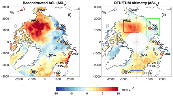
This study uses a novel satellite-independent approach to quantify the components of Arctic sea level change. The 21-year time series allows studying climate-related changes in Arctic sea level. The decomposition shows that fresh water is governing sea level change, while Arctic land ice loss contributes to a small Arctic sea level rise. The reconstruction yields good agreement with sea level observations from altimetry, despite both datasets being challenged by the harsh environment.
Cited articles
Abdalla, S., Abdeh Kolahchi, A., Ablain, M., et al.: Altimetry for the future: building on 25 years of progress, Adv. Space Res., 68, 319–363, https://doi.org/10.1016/j.asr.2021.01.022, 2021. a, b
Andersen, O. B. and Knudsen, P.: DNSC08 mean sea surface and mean dynamic topography models, J. Geophys. Res.-Oceans, 114, 2008JC005179, https://doi.org/10.1029/2008JC005179, 2009. a, b
Andersen, O. B. and Nilsson, B.: DTU25MSS Mean Sea Surface, Technical University of Denmark (DTU) [data set], https://doi.org/10.11583/DTU.29412275.v1, 2025. a, b, c
Archer, M., Wang, J., Klein, P., Dibarboure, G., and Fu, L.-L.: Wide-swath satellite altimetry unveils global submesoscale ocean dynamics, Nature, 640, 691–696, https://doi.org/10.1038/s41586-025-08722-8, 2025. a, b
Ardhuin, F., Molero, B., Bohé, A., Nouguier, F., Collard, F., Houghton, I., Hay, A., and Legresy, B.: Phase-resolved swells across ocean basins in SWOT altimetry data: revealing centimeter-scale wave heights including coastal reflection, Geophys. Res. Lett., 51, e2024GL109658, https://doi.org/10.1029/2024GL109658, 2024. a
Arildsen, R. L., Andersen, O. B., Nilsson, B., and Ludwigsen, C. B.: Tidal bore revealed by SWOT: a case study from the Severn river, Sci. Rep.-UK, 15, 22776, https://doi.org/10.1038/s41598-025-99597-2, 2025. a
AVISO/DUACS: SWOT Level-3 KaRIn Low Rate SSH Expert (v2.0.1), https://doi.org/10.24400/527896/A01-2023.018, 2025a. a, b, c
AVISO/DUACS: DUACS Level-3 SWOT KaRIn User Handbook, Issue 2.1, https://doi.org/10.24400/527896/A01-2023.017, 2025b. a, b, c
AVISO/DUACS: SWOT Level-3 KaRIn Low Rate SSH Unsmoothed (v2.0.1), https://doi.org/10.24400/527896/A01-2024.003, 2025c. a, b
Bohe, A., Chen, A., Chen, C., Dibarboure, G., Dubois, P., Fore, A., Hajj, G., Legresy, B., Lenain, L., Molero, B., Peral, E., Raynal, M., and Stiles, B.: Measuring Significant Wave Height fields in two dimensions at kilometric scales with SWOT, EGU General Assembly 2024, Vienna, Austria, 14–19 Apr 2024, EGU24-10457, https://doi.org/10.5194/egusphere-egu24-10457, 2024. a
Callaghan, D. P., Nielsen, P., Cartwright, N., Gourlay, M. R., and Baldock, T. E.: Atoll lagoon flushing forced by waves, Coast. Eng., 53, 691–704, https://doi.org/10.1016/j.coastaleng.2006.02.006, 2006. a
Carli, E., Siegelman, L., Morrow, R., and Vergara, O.: Surface quasi geostrophic reconstruction of vertical velocities and vertical heat fluxes in the Southern Ocean: perspectives for SWOT, J. Geophys. Res.-Oceans, 129, e2024JC021216, https://doi.org/10.1029/2024JC021216, 2024. a
Chen, X., Zhang, S., Andersen, O. B., and Jia, Y.: Along-track marine geoid resolution enhancement with SWOT, Earth and Space Science, 12, e2024EA003893, https://doi.org/10.1029/2024EA003893, 2025. a
Dibarboure, G. and Pujol, M.-I.: Improving the quality of Sentinel-3A data with a hybrid mean sea surface model, and implications for Sentinel-3B and SWOT, Adv. Space Res., 68, 1116–1139, https://doi.org/10.1016/j.asr.2019.06.018, 2021. a, b
Douze, M., Guzhva, A., Deng, C., Johnson, J., Szilvasy, G., Mazaré, P.-E., Lomeli, M., Hosseini, L., and Jégou, H.: The Faiss Library, arXiv [preprint], https://doi.org/10.48550/arXiv.2401.08281, 2024. a, b
DTU Computing Center: DTU Computing Center Resources, https://doi.org/10.48714/DTU.HPC.0001, 2025. a
Fu, L.-L. and Cazenave, A.: Satellite Altimetry and Earth Sciences, Vol. 69 of International Geophysics, Elsevier, https://doi.org/10.1016/S0074-6142(01)80145-5, xi–xii, 2001. a
Fu, L.-L., Pavelsky, T., Cretaux, J.-F., Morrow, R., Farrar, J. T., Vaze, P., Sengenes, P., Vinogradova-Shiffer, N., Sylvestre-Baron, A., Picot, N., and Dibarboure, G.: The surface water and ocean topography mission: a breakthrough in radar remote sensing of the ocean and land surface water, Geophys. Res. Lett., 51, e2023GL107652, https://doi.org/10.1029/2023GL107652, 2024. a, b
Gardner, J. R., Pleiss, G., Bindel, D., Weinberger, K. Q., and Wilson, A. G.: GPyTorch: Blackbox Matrix-Matrix Gaussian Process Inference with GPU Acceleration, [cs, stat], arXiv [preprint], https://doi.org/10.48550/arXiv.1809.11165, 2021. a, b
Hart-Davis, M. G., Andersen, O. B., Ray, R. D., Zaron, E. D., Schwatke, C., Arildsen, R. L., Dettmering, D., and Nielsen, K.: Tides in complex coastal regions: early case studies from wide-swath SWOT measurements, Geophys. Res. Lett., 51, e2024GL109983, https://doi.org/10.1029/2024GL109983, 2024. a, b
JPL: SWOT Algorithm Theoretical Basis Document: Level 2 KaRIn Low Rate Sea Surface Height (L2_LR_SSH) Science Algorithm Software, https://podaac.jpl.nasa.gov/dataset/SWOT_L2_LR_SSH_BASIC_2.0 (last access: 5 July 2026), 2023. a
Laloue, A., Schaeffer, P., Pujol, M.-I., Veillard, P., Andersen, O., Sandwell, D., Delepoulle, A., Dibarboure, G., and Faugère, Y.: Merging recent mean sea surface into a 2023 hybrid model (From Scripps, DTU, CLS, and CNES), Earth and Space Science, 12, e2024EA003836, https://doi.org/10.1029/2024EA003836, 2025. a, b, c, d, e, f
Monahan, T., Tang, T., Roberts, S., and Adcock, T. A. A.: Tidal corrections from and for SWOT using a spatially coherent variational Bayesian harmonic analysis, J. Geophys. Res.-Oceans, 130, e2024JC021533, https://doi.org/10.1029/2024JC021533, 2025. a
Mulet, S., Rio, M.-H., Etienne, H., Artana, C., Cancet, M., Dibarboure, G., Feng, H., Husson, R., Picot, N., Provost, C., and Strub, P. T.: The new CNES-CLS18 global mean dynamic topography, Ocean Sci., 17, 789–808, https://doi.org/10.5194/os-17-789-2021, 2021. a
Nencioli, F., Raynal, M., Ubelmann, C., Cadier, E., Prandi, P., and Dibarboure, G.: An altimeter-based assessment of SWOT KaRIn spectral error requirements, Adv. Space Res., S027311772500554X, https://doi.org/10.1016/j.asr.2025.05.073, 2025. a
Nerem, R. S., Beckley, B. D., Fasullo, J. T., Hamlington, B. D., Masters, D., and Mitchum, G. T.: Climate-change–driven accelerated sea-level rise detected in the altimeter era, P. Natl. Acad. Sci. USA, 115, 2022–2025, https://doi.org/10.1073/pnas.1717312115, 2018. a
Nilsson, B., Andersen, O. B., and Knudsen, P.: Assessment of the performance of SWOT for observing the static ocean topography, Geophys. Res. Lett., 52, e2024GL112290, https://doi.org/10.1029/2024GL112290, 2025. a, b, c, d
Peral, E., Esteban-Fernández, D., Rodríguez, E., McWatters, D., De Bleser, J.-W., Ahmed, R., Chen, A. C., Slimko, E., Somawardhana, R., Knarr, K., Johnson, M., Jaruwatanadilok, S., Chan, S., Wu, X., Clark, D., Peters, K., Chen, C. W., Mao, P., Khayatian, B., Chen, J., Hodges, R. E., Boussalis, D., Stiles, B., and Srinivasan, K.: KaRIn, the Ka-Band Radar Interferometer of the SWOT mission: design and in-flight performance, IEEE T. Geosci. Remote, 62, 1–27, https://doi.org/10.1109/TGRS.2024.3405343, 2024. a
Pujol, M.-I., Schaeffer, P., Faugère, Y., Raynal, M., Dibarboure, G., and Picot, N.: Gauging the improvement of recent mean sea surface models: a new approach for identifying and quantifying their errors, J. Geophys. Res.-Oceans, 123, 5889–5911, https://doi.org/10.1029/2017JC013503, 2018. a
Qiu, B., Chen, S., Wang, J., and Fu, L.-L.: Seasonal and fortnight variations in internal solitary waves in the Indonesian seas from the SWOT measurements, J. Geophys. Res.-Oceans, 129, e2024JC021086, https://doi.org/10.1029/2024JC021086, 2024. a
Rasmussen, C. E. and Williams, C. K. I.: Gaussian processes for machine learning, Adaptive computation and machine learning, MIT Press, Cambridge, Mass, 2006. a
Rodriguez, E., Esteban Fernandez, D., Peral, E., Chen, C. W., De Bleser, J.-W., and Williams, B.: Wide-Swath Altimetry, 1st edn., CRC Press, https://doi.org/10.1201/9781315151779-2, 71–112, 2017. a, b
Salameh, E., Desroches, D., Deloffre, J., Fjørtoft, R., Mendoza, E. T., Turki, I., Froideval, L., Levaillant, R., Déchamps, S., Picot, N., Laignel, B., and Frappart, F.: Evaluating SWOT's interferometric capabilities for mapping intertidal topography, Remote Sens. Environ., 314, 114401, https://doi.org/10.1016/j.rse.2024.114401, 2024. a
Sandwell, D. T.: Adding Mean Sea Surface (MSS) as an Altimetry Product, SIO Technical Report, https://topex.ucsd.edu/pub/MSS_replace/MSS_construction_10.pdf (last access: 5 July 2026), 2022. a
Sandwell, D. T. and Smith, W. H. F.: Slope correction for ocean radar altimetry, J. Geodesy, 88, 765–771, https://doi.org/10.1007/s00190-014-0720-1, 2014. a, b
Savitzky, A. and Golay, M. J. E.: Smoothing and differentiation of data by simplified least squares procedures, Anal. Chem., 36, 1627–1639, https://doi.org/10.1021/ac60214a047, 1964. a
Schaeffer, P., Pujol, M.-I., Veillard, P., Faugere, Y., Dagneaux, Q., Dibarboure, G., and Picot, N.: The CNES CLS 2022 mean sea surface: short wavelength improvements from CryoSat-2 and SARAL/AltiKa high-sampled altimeter data, Remote Sens.-Basel, 15, 2910, https://doi.org/10.3390/rs15112910, 2023. a, b
Scharroo, R., Leuliette, E., Lillibridge, J., Byrne, D., Naeije, M., and Mitchum, G.: RADS: Consistent multi-mission products, in: Proc. of the Symposium on 20 Years of Progress in Radar Altimetry, European Space Agency Special Publication, Venice, Italy, https://doi.org/10.5270/esa.sp-710.altimetry2012, 2012. a, b
Shi, H., Jia, D., He, X., Andersen, O. B., and Zheng, X.: SWOT-based intertidal digital elevation model extraction and spatiotemporal variation assessment, Remote Sens.-Basel, 17, 1516, https://doi.org/10.3390/rs17091516, 2025. a, b
Stammer, D. and Cazenave, A.: Satellite Altimetry over Oceans and Land Surfaces, Earth Observation of Global Changes, CRC Press, Boca Raton London New York, https://doi.org/10.1201/9781315151779, 2018. a
Stiles, B. and Dubois, P.: Level 2 KaRIn Low Rate Sea Surface Height Science Algorithm, Initial Release, https://podaac.jpl.nasa.gov/swot?tab=datasets (last access: 5 July 2026), 2023. a
Tomić, M. and Andersen, O. B.: ICESat-2 for coastal MSS determination – evaluation in the Norwegian coastal zone, Remote Sens.-Basel, 15, 3974, https://doi.org/10.3390/rs15163974, 2023. a, b
Tomić, M., Breili, K., Gerlach, C., and Ophaug, V.: Validation of retracked Sentinel-3 altimetry observations along the Norwegian coast, Adv. Space Res., 73, 4067–4090, https://doi.org/10.1016/j.asr.2024.01.055, 2024. a
Tu, Z., Jiang, T., and Zhao, F.: Marine gravity field modeling using SWOT altimetry data in South China Sea, Journal of Marine Science and Engineering, 13, 827, https://doi.org/10.3390/jmse13050827, 2025. a
Veng, T. and Andersen, O. B.: Consolidating sea level acceleration estimates from satellite altimetry, Adv. Space Res., 68, 496–503, https://doi.org/10.1016/j.asr.2020.01.016, 2021. a
Welch, P.: The use of fast Fourier transform for the estimation of power spectra: A method based on time averaging over short, modified periodograms, IEEE T. Acoust. Speech., 15, 70–73, https://doi.org/10.1109/TAU.1967.1161901, 1967. a
Yu, Y., Sandwell, D. T., and Dibarboure, G.: Abyssal marine tectonics from the SWOT mission, Science, 386, 1251–1256, https://doi.org/10.1126/science.ads4472, 2024a. a, b
Yu, Y., Sandwell, D. T., Dibarboure, G., Chen, C., and Wang, J.: Accuracy and resolution of SWOT altimetry: foundation seamounts, Earth and Space Science, 11, e2024EA003581, https://doi.org/10.1029/2024EA003581, 2024b. a, b
Yuan, J., Guo, J., Zhu, C., Li, Z., Liu, X., and Gao, J.: SDUST2020 MSS: a global mean sea surface model determined from multi-satellite altimetry data, Earth Syst. Sci. Data, 15, 155–169, https://doi.org/10.5194/essd-15-155-2023, 2023. a
Zhang, L., Hwang, C., Liu, H.-Y., Chang, E. T. Y., and Yu, D.: Automated eddy identification and tracking in the northwest Pacific based on conventional altimeter and SWOT data, Remote Sens.-Basel, 17, 1665, https://doi.org/10.3390/rs17101665, 2025. a
Zhu, C., Guo, J., Ya, S., Li, W., Gao, J., and Qiu, L.: Moving geoid gradient method for high-precision and high-resolution gravity recovery from SWOT wide-swath data, IEEE T. Geosci. Remote, 1, https://doi.org/10.1109/TGRS.2025.3563949, 2025. a
Short summary
The average height of the sea surface is important to understand if we are to accurately understand either the dynamic ocean or improve our understanding of the shape of the earth's surface. Currently we have been able to understand this to a certain degree, but with data from the new Surface Water and Ocean Topography (SWOT) satellite, we are now able to map the sea surface at a very small scale. We utilize this new data to better understand and map the shape of the global oceans.
The average height of the sea surface is important to understand if we are to accurately...
Altmetrics
Final-revised paper
Preprint