the Creative Commons Attribution 4.0 License.
the Creative Commons Attribution 4.0 License.
 | 16 Jul 2026
Mercury dataset over the Third Pole
Shichang Kang
Jie Huang
Qianggong Zhang
Junming Guo
Xiufeng Yin
Shiwei Sun
Xuejun Sun
Lekhendra Tripathee
Sabur Abdullaev
Wenjun Tang
Yi Zhang
Xiwen Miao
Liujian Liao
Lusheng Che
The Tibetan Plateau and its surrounding regions, collectively known as the Third Pole, constitute one of Earth's largest topographic and cryospheric features, playing a pivotal role in the cycling of trace elements at both regional and global scales. Mercury (Hg), a toxic heavy metal of global concern, has garnered increasing attention due to its detrimental effects on environmental and human health. Large-scale atmospheric circulation facilitates the long-range transport of atmospheric Hg pollutants, which can subsequently be deposited across the Third Pole. Over recent decades, the Atmospheric Pollution and Cryospheric Change (APCC) program has established and sustained an integrated monitoring network throughout this region to systematically examine the interactions between Hg biogeochemical cycling and cryospheric changes. This paper presents a comprehensive Hg dataset encompassing air (2 stations), aerosols (9 stations), precipitation (16 stations), glaciers (12 glaciers; including snowpit, surface snow, and cryoconite samples), soils (50 sites), surface waters (53 locations; including river, lake, and glacial meltwater), glacier ice cores (1 core), and lake sediment cores (8 cores) collected across the Third Pole. The data were acquired through both in situ (online) monitoring and laboratory analyses. High-resolution atmospheric Hg concentrations were measured using a Tekran 2537B analyzer at the Nam Co and Tanglha stations. Spatial and temporal distributions of Hg in aerosols, precipitation, glaciers, soils, and sediment cores revealed distinct patterns and trends across different sectors of the Third Pole, influenced significantly by emission sources, transport pathways, and environmental processes. Depositional chronologies derived from glacier ice and lake sediment cores reflect anthropogenic perturbations in the historical Hg record since the Industrial Revolution. Stable Hg isotope compositions from aerosols, soils, and lake sediments provide evidence for transboundary transport of Hg pollution and its northward incursion into the interior Tibetan Plateau from South Asia. This updated dataset is made publicly available to support interdisciplinary research linking the cryosphere, atmosphere, soils, and hydrology. The APCC dataset (v1.0) is archived at the Cold and Arid Regions Science Data Center at Lanzhou, released on 3 December 2024 with the persistent DOI https://doi.org/10.12072/ncdc.qzkk.db6654.2024 (Kang et al., 2024).
- Article
(8763 KB) - Full-text XML
- BibTeX
- EndNote


The Tibetan Plateau and its surrounding regions, referred to as the Third Pole, form the highest and most extensive plateau on Earth, with an average elevation exceeding 4000 m a.s.l. and an area of approximately 2.5 million km2. Known as the “Asian Water Tower” (Immerzeel et al., 2010; Yao et al., 2022), this hydrologically critical region acts as the headwater source for many major Asian rivers, supplying freshwater to billions of people downstream. Owing to its vast and complex topography, the Third Pole significantly influences climate systems, cryospheric changes, environmental processes, and biogeochemical cycles at both regional and global scales. It has experienced accelerated warming at a rate of 0.34 °C decade−1 (You et al., 2021), surpassing the Northern Hemisphere average (0.29 °C decade−1) and global trends (Kang et al., 2010; Chen et al., 2015). This pronounced warming drives rapid cryospheric loss, including glacier retreat, permafrost degradation, and decline in snow cover (Yao et al., 2019), profoundly impacting Earth system dynamics across the Third Pole.
Mercury (Hg) is a globally prioritized pollutant owing to its high toxicity, bioavailability, and capacity for trophic magnification in aquatic ecosystems (Kim et al., 2016). Methyl Hg (MeHg), one of the most concerning organic Hg species (Mergler et al., 2007), bioaccumulates in aquatic food webs and biomagnifies across trophic levels, posing substantial neurotoxic threats to human health (Grandjean et al., 2010; Beckers and Rinklebe, 2017). Recognized as a critically problematic contaminant (Driscoll et al., 2013), Hg became regulated under international policy through the adoption of the Minamata Convention in 2013 (Kessler, 2013; Selin et al., 2018).
Under rapid warming conditions, environmental transformations across the Third Pole may exhibit distinctive features in Hg biogeochemical cycling (Kang et al., 2019; Sun et al., 2020a). However, the remote and expansive nature of the region-coupled with complex topography, limited accessibility, extreme climate, and harsh environmental conditions-poses considerable challenges for Hg investigation across various compartments. Although regional and global chemical transport models (e.g., GEOS-Chem, CMAQ-Hg) have provided valuable insights into Hg dynamics (Lin et al., 2010; Wang et al., 2014), observational data remain essential for validating and refining atmospheric transport models in this data-scarce region. Furthermore, while models excel at simulating spatial patterns of Hg over broad scales, they often lack the temporal resolution needed to capture rapid changes and underlying transformation mechanisms-gaps that high-resolution Hg measurements can help address. The current scarcity of Hg data underscores the urgent need for enhanced observational efforts across the Third Pole. In recent decades, our research team has established the Atmospheric Pollution and Cryospheric Change (APCC) program-an integrated monitoring network and research initiative focused on interactions between atmospheric pollution and cryospheric environments across the Third Pole (Kang et al., 2019). Building on the APCC framework, recent advances in observational instrumentation and techniques have been employed to characterize environmental Hg processes, including its spatial and temporal distributions, transport pathways, and deposition mechanisms in this region. A series of observational findings linked to the APCC program have been consistently published. Consequently, research on Hg across various environmental compartments of the Third Pole has achieved substantial scientific progress over the past decades. In this paper, we provide a concise overview of our previous studies and present an organized compilation of systematic Hg datasets derived from air, aerosols, precipitation, glaciers, soils, surface water (river, lake, and glacial meltwater), glacier ice and lake sediment core across the Third Pole.
The paper is structured as follows: Sects. 2 and 3 outline the descriptions of observation sites, field sampling procedures, and measurement methodologies; Sect. 4 provides a comprehensive presentation of Hg datasets from air, aerosols, precipitation, glaciers, soils, surface water, glacier ice, and lake sediment cores, along with a detailed description of Hg stable isotope compositions in aerosols, soils, and lake sediments; Sect. 5 provides the data description; Sect. 6 addresses data accessibility; and Sect. 7 presents the concluding remarks.
2.1 Overview of site distributions
The Third Pole comprises the Himalayas and Tibetan Plateau (hereafter Himalaya-Tibet), along with surrounding areas including China's Xinjiang Uyghur Autonomous Region and parts of South Asia (e.g., Nepal, India) and Central Asia (e.g., Kazakhstan, Tajikistan) (Fig. 1). Topographically, it is characterized by the high-altitude Himalaya-Tibet region (mean elevation > 4000 m a.s.l.) in the south and extensive arid basins (e.g., Tarim, Qaidam) in the northwest. The region is divided into two atmospheric regimes: a northern domain dominated by westerlies (winter) and a southern domain influenced by monsoons (summer), driven by seasonal circulation shifts (Fig. 1).
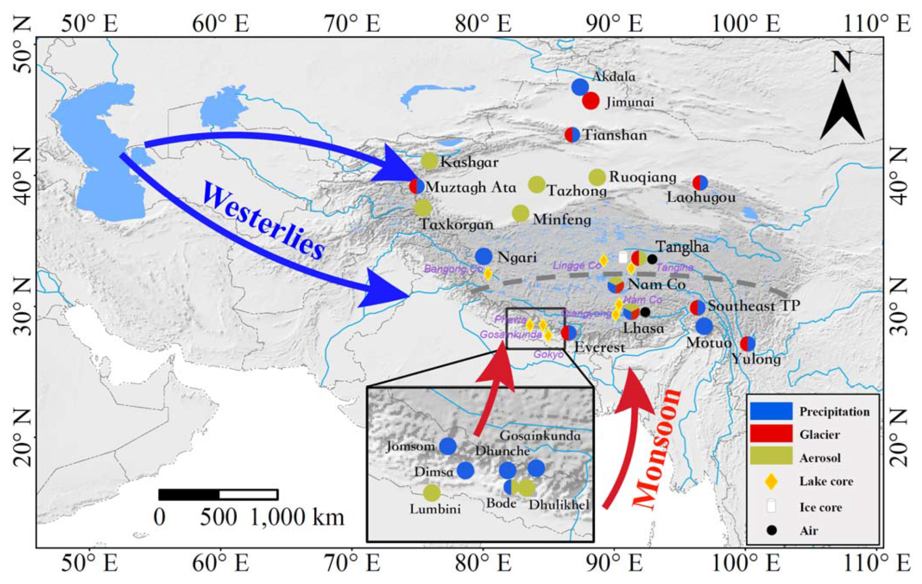
Figure 1A map of the Third Pole, showing the geographical locations of the observation sites (see Table 1 for the detailed information of each station) from the Atmospheric Pollution and Cryospheric Change (APCC) program. Also shown are the general patterns of atmospheric circulation systems. The gray dashed line shows the northern boundary of the Indian monsoon based on seasonal δ18O changes in precipitation (Tian et al., 2007), which divides the Tibetan Plateau into the monsoon domain in the south and the westerlies domain in the north.
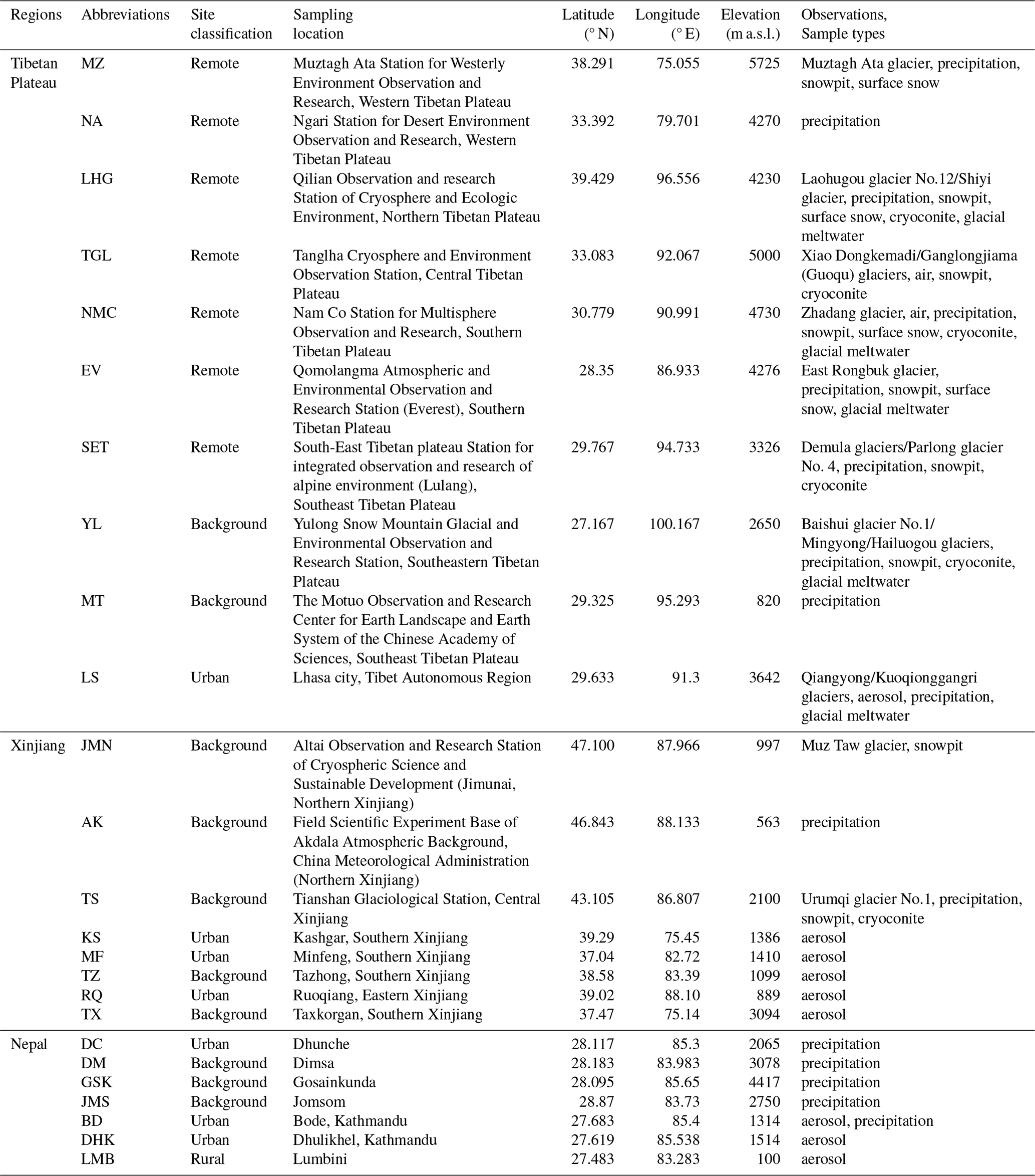
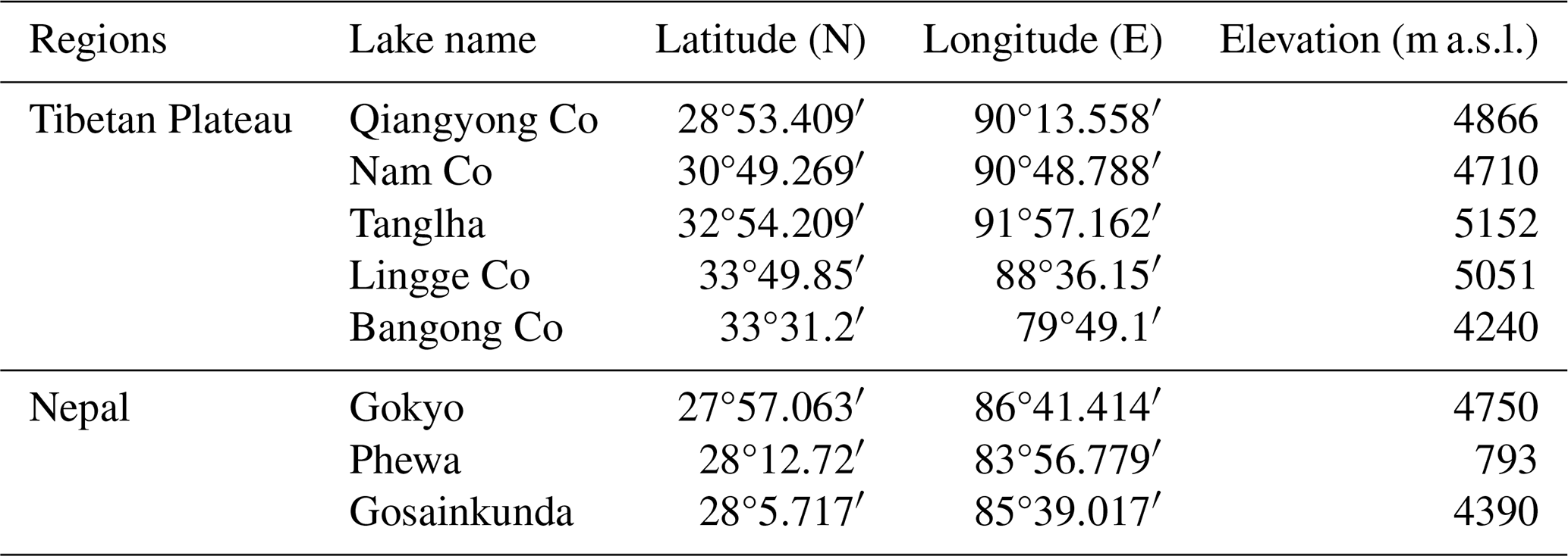
Under the APCC program, multi-compartment Hg observations were conducted across dozens of stations (Fig. 1; Table 1), including: 2 stations for online air monitoring, 9 stations for aerosol sampling, 16 stations for precipitation collection, 12 glaciers for snowpit, surface snow, and cryoconite sampling, 50 sites for soil sampling, and 53 locations for surface water sampling. Sampling elevations ranged from 13 to 6000 m a.s.l., covering diverse landscapes (e.g., forest, grassland, glacier, river, lake, frozen ground, and desert). Additionally, one alpine ice core and eight lake sediment cores were obtained to reconstruct historical Hg deposition (Fig. 1; Tables 2, 3). This study releases a comprehensive Hg dataset from these environmental matrices (APCC datasets I-1 to I-8). All sampling details-location, elevation, and sample type-are provided in Table 1 and illustrated in Fig. 1. Sites are described in the following sections by environmental category.
Table 1Detailed geographic characteristics of observation stations from the Atmospheric Pollution and Cryospheric Change (APCC) program in this paper.
2.2 Air sites
Total gaseous Hg (TGM) concentrations were monitored at two inland Tibetan Plateau stations: Nam Co Station (30°46.44′ N, 90°59.31′ E; 4730 m a.s.l.) and Tanglha Station ( N, E; 5050 m a.s.l.) (APCC dataset I-1; Yin et al., 2018; Sun et al., 2020b). Both sites experience minimal local anthropogenic influence. Land-air Hg exchange fluxes were additionally quantified at Tanglha Station (Sun et al., 2020b).
The Nam Co Station, located between Nam Co Lake and the Nyainqêntanglha mountain range, is characterized by minimal local anthropogenic Hg emission sources (Fig. 1). Situated in continuous permafrost with alpine grassland landscapes, Tanglha Station lies near the northern limit of Indian summer monsoon (ISM) intrusion (Fig. 1). Atmospheric circulation shifts seasonally between ISM (warm months) and mid-latitude westerlies (cold seasons) (Tian et al., 2007; Yao et al., 2013). The nearest settlements-Yanshiping (65 km north) and Anduo (110 km south)-are distant, with nomadic grazing as the primary human activity. This station provides an ideal setting for studying atmospheric Hg dynamics, including long-range transport and land-air exchange processes, in the remote central Tibetan Plateau (Sun et al., 2020b).
2.3 Aerosol sites
Aerosol Hg sampling was conducted at 9 sites across the Third Pole (Fig. 1; APCC dataset I-2). Three stations-Bode (BD), Dhulikhel (DHK), and Lumbini (LMB)-are located on the southern Himalayan slope in Nepal, capturing Hg emissions from urban, agricultural, and industrial sources to trace transboundary pollution transport (Guo et al., 2017, 2021, 2022). Kathmandu (BD and DHK sites) represents a rapidly urbanizing area with severe air pollution; LMB, a UNESCO World Heritage site situated in the Indo-Gangetic Plains, reflects mixed agricultural and industrial influences. On the Tibetan Plateau, aerosol Hg was measured at Lhasa Station (LS) (Fig. 1), the region's largest city, where economic growth has intensified local Hg pollution through urbanization and industrial expansion (Huang et al., 2016). Five additional stations were established in the Taklimakan Desert (Fig. 1)-Kashgar (KS), Taxkorgan (TX), Minfeng (MF), Ruoqiang (RQ), and Tazhong (TZ)-to monitor dust-associated Hg in this major Northern Hemisphere dust source (APCC dataset I-2; Huang et al., 2020a).
2.4 Precipitation sites
Precipitation Hg was measured at 16 stations across the Third Pole (APCC dataset I-3; Huang et al., 2022, 2024), including 11 stations in western China and 5 stations in Nepal. In western China, 6 stations are located in the monsoon domain: Nam Co (NMC), Lhasa (LS), Southeast Tibet (SET), Mt. Everest (EV), Yulong (YL) and Motuo (MT). The remaining 5 stations fall within the westerlies domain: Akedala (AK), Tianshan (TS), Muztagh Ata (MZ), Laohugou (LHG), and Ngari (NA) (Fig. 1; Table 1). Both regions show strong seasonal precipitation concentration, with ∼ 80 % (monsoon) and ∼ 86 % (westerlies) occurring in summer due to moisture transport from the Indian Ocean and North Atlantic, respectively, and minimal rainfall from October to April (Huang et al., 2022).
On the southern Himalayan slopes, 5 precipitation Hg sampling stations were established in Nepal (APCC dataset I-3; Table 1), spanning urban to remote alpine environments: Kathmandu (1314 m a.s.l.), Dhunche (DC) (2065 m a.s.l.), Jomsom (JMS) (2750 m a.s.l.), Dimsa (DM) (3078 m a.s.l.), and Gosainkunda (GSK) (4417 m a.s.l.) (Tripathee et al., 2019, 2020). These sites represent varied settings-urban, rural, forested, and high-altitude remote areas-along key geographic and trekking corridors in the central Himalayas.
2.5 Glacier sites
Hg distribution across glaciers in the Third Pole was systematically documented using a dataset from 12 glaciers (Zhang et al., 2012; APCC dataset I-4), selected to represent diverse climatic and geographic settings. Sampling elevations ranged from ∼ 3600 m a.s.l. (Muz Taw Glacier, northern Xinjiang) to ∼ 6500 m a.s.l. (East Rongbuk Glacier, Mt. Everest) (Tables 1 and 2), providing a pronounced spatial and temporal gradients for examining Hg variability.
Table 2Detailed information for the observed glaciers based on the APCC program in this paper.
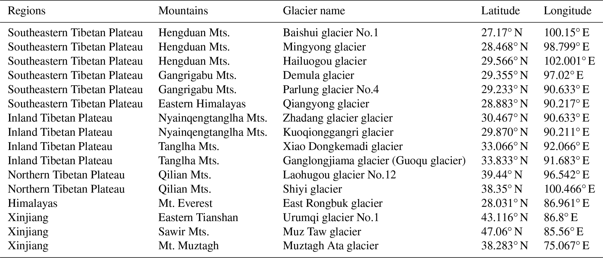
Note: An ice core with depth of 147 m was collected in 2005 from the upper basin of the Ganglongjiama glacier (Guoqu glacier, 33.58° N, 91.18° E; 5750 m a.s.l.) on the northern slope of the Mt. Geladaindong. Mts.: Mountains
Five glaciers are located within the monsoon domain (Fig. 1 and Table 2): Baishui No.1 (Mt. Yulong), Demula and Yarlong No.4 (southeastern Tibetan Plateau), East Rongbuk (central Himalayas), and Zhadang (western Nyainqentanglha Mts.). Seven glaciers fall within the westerlies domain (Fig. 1 and Table 2): Xiao Dongkemadi (headwaters of the Yangtze River, Tanglha Mts.), Ganglongjiama (Mt. Geladaindong, Tanglha Mts.), Laohugou No.12 (Qilian Mts.), Shiyi (Yeniugou basin, Qilian Mts.), Muztag Ata (Pamir Plateau), Urumqi No.1 (headwaters of Urumqi River, eastern Tianshan), and Muz Taw (Sawir Mts., northern Xinjiang).
2.6 Soil sites
The Third Pole contains the most extensive low- and mid-latitude permafrost on Earth, accounting for 74.5 % of Northern Hemisphere high-mountain permafrost (Yang et al., 2010). A total of 31 surface frozen soil samples (5 ± 0.5 cm depth) were collected from permafrost sites > 3000 m a.s.l. along this transect, including 21 sites on the southern Himalayan slope and 10 on the northern slope (Huang et al., 2020b; APCC dataset I-5).
Climatic, topographic, and biological gradients support diverse vegetation types including forests, steppes, meadows, grasslands, and shrublands (Yin et al., 2024). A total of 336 soil samples were collected from 28 sites (meadow: n=5; grassland: n=7; desert: n=10; forest: n=6) across the Tibetan Plateau (2917–4762 m a.s.l.). An additional 36 soil samples were obtained from Langtang National Park (28.15–28.21° N, 85.39–85.56° E) in the Nepal Himalayas.
Topsoil samples (0–5 cm) were also collected from arid regions of Central Asia (Tajikistan, Uzbekistan, Kyrgyzstan; Figs. 1 and 6), covering 2.45 × 10⁶ km2. These 182 samples (Yang et al., 2023; APCC dataset I-5) enable comparative analysis of soil Hg across different arid landscapes and assessment of anthropogenic impacts in Central Asia.
2.7 Surface water sites
Surface water Hg datasets (APCC dataset I-6) across the Third Pole include 2 rivers (Zheng et al., 2010; Sun et al., 2020c), 42 lakes (Li et al., 2015), and 9 glacier-fed streams (Sun et al., 2016, 2017, 2022; Paudyal et al., 2017, 2019; Pu et al., 2024; Wang et al., 2024). The rivers comprise the Yarlung Zangbo (Brahmaputra upstream), a high-altitude (> 4000 m a.s.l.) system originating from the Jiemayangzong Glacier (30°48′ N, 82°42′ E) and draining 239 228 km2 across southern Tibet, and the transboundary Koshi River, which flows through China (33 % of its 87 311 km2 basin), Nepal (45 %), and India (22 %).
Lake waters were sampled from 42 endorheic lakes (APCC dataset I-6) spanning altitudes of 3469–5145 m a.s.l. and surface areas from < 1 to > 1000 km2, providing broad geographic and limnological coverage of Hg distribution patterns (Li et al., 2015).
Glacial meltwater sampling covered 9 glacier runoffs (APCC dataset I-6) representing key regions: Laohugou No.12 (Qilian Mts.), Xiao Dongkemadi (Tanglha Mts.), Zhadang and Kuoqionggangri (Nyainqentanglha Mts.), Qiangyong and Rongbuk (Himalayas), and Hailuogou (Mt. Gongga), Baishuihe No.1 (Mt. Yulong), and Mingyong (Mt. Meili) on the southeastern Tibetan Plateau.
2.8 Glacier ice and sediment cores sites
A 147 m ice core was retrieved in 2005 from Ganglongjiama Glacier (same as Guoqu Glacier, 33.58° N, 91.18° E; 5750 m a.s.l.) on Mt. Geladaindong (6621 m a.s.l.), which is the headwaters of the Yangtze River and the highest peak in the Tanglha Range, central Tibetan Plateau (Kang et al., 2016; APCC dataset I-7; Fig. 1).
Eight profundal sediment cores were collected between 2008 and 2011 using a 6 cm diameter gravity corer from Himalayan (Phewa, Gokyo, Gosainkunda) and Tibetan (Qiangyong Co, Nam Co, Bangong Co, Lingge Co, Tanglha) Lakes (APCC dataset I-7; Fig. 1; Table 3). These lakes represent key environmental gradients: Phewa Lake (28.21° N, 83.95° E; 782 m a.s.l.; 4.35 km2; 22.5 m depth) receives urban/agricultural runoff in the Pokhara Valley; Gosainkunda Lake (28.08° N, 85.42° E; 4300 m a.s.l.; 0.14 km2; 24.1 m depth) is an oligotrophic system in Langtang National Park; Gokyo Lake (27°58′ N, 86°40′ E; 4700–5000 m a.s.l.) is an ultra-oligotrophic system near Mt. Everest. The five Tibetan lakes span southern (Qiangyong Co), southwestern (Bangong Co), and inland (Nam Co, Lingge Co, Tanglha) regions (Fig. 1).
Table 3Detailed information for the lake sediments cores in this paper.
Building on the site descriptions in Sect. 2, this section details the field sampling procedures and laboratory analytical methods. Specific site information (e.g., elevation, latitude, longitude) linked to the sample collection protocols is presented in Tables 1–4, and laboratory protocols supporting QA/QC procedures are provided in Table 5, respectively.
Table 4APCC subset repository overview for the Third Pole Hg dataset.
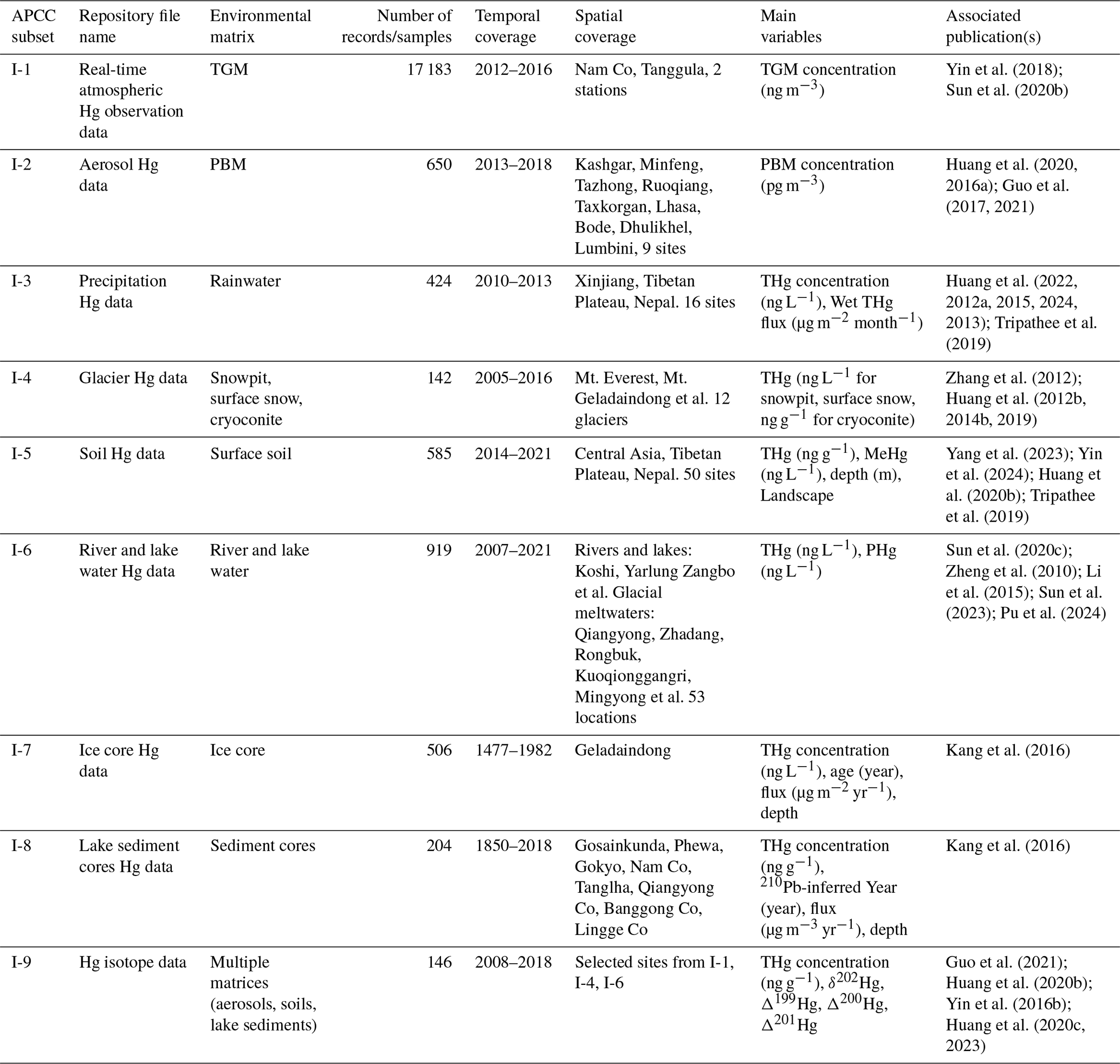
Table 5Comprehensive QA/QC details for Hg analysis across all sample matrices.
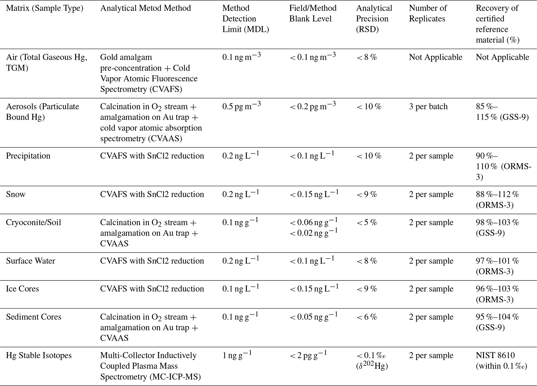
Notes: MDL = method detection limit; RSD = relative standard deviation. Certified reference materials (CRMs) are indicated in parentheses. Continuous online TGM monitoring recorded measurements at 5 min intervals without replicates. The certified reference material for measuring air samples (Total Gaseous Mercury, TGM) was generated using a Tekran Model 2505 Mercury Vapor Calibration Unit, which is an ultra-precise and accurate closed-vessel saturated gaseous mercury source.
3.1 Air
Atmospheric TGM was monitored at Nam Co Station (2012–2014) using a Tekran 2537B analyzer (Tekran Instruments Corp., Canada). Air was sampled through a rooftop inlet equipped with a 0.2 µm Teflon filter, replaced biweekly. The instrument employed dual gold cartridges for continuous Hg collection, thermal desorption, and detection by CVAFS at 253.7 nm. Sampling interval was 5 min at 0.8 L min−1. Calibration was performed automatically every 25 h and manually annually using a Tekran 2505 unit. TGM at this site consisted predominantly (> 98 %) of gaseous elemental Hg (GEM) (Yin et al., 2018; de Foy et al., 2016).
At Tanglha Station, TGM was measured similarly with a ground-level inlet ∼ 1 m above the surface, but only for a short period of one month (January 2016) (Sun et al., 2020b). The relative standard deviation (RSD) values for TGM determinations were lower than 8 % (Table 5). Land-air Hg fluxes were quantified using a dynamic flux chamber (DFC) coupled to a Tekran 2537B, alternating between ambient and chamber air every 5 min at 1.5 L min−1. Hg fluxes were calculated from the TGM difference, normalized to flow rate and chamber area. A 0.2 µm Teflon filter was used to remove particulate-bound Hg (HgP) from sampled air. Quality assurance showed system blanks of 0.00 ± 0.01 ng m−3 in 95 % of measurements. Flux blanks averaged 0.002±0.010 ng m−2 h−1, demonstrating negligible systematic bias (Sun et al., 2020b).
3.2 Aerosol
Total Suspended Particles (TSP) were collected on pre-combusted quartz fiber filters (Whatman® GF/F; 90 mm, 2.2 µm pore size) using high-volume samplers (KC-120H or RP 1400a) operated at 100 L min−1. Sampling durations were 24 h at urban/rural sites and 48 h at remote sites. Samplers were mounted on building rooftops to minimize ground interference. Filters were equilibrated (> 24 h, 25 °C, 30 % RH) before and after sampling for gravimetric analysis. Collected samples were sealed and stored at 4 °C until analysis.
Aerosol Hg concentrations were measured in duplicate using a Leeman Hydra IIC Direct Hg Analyzer (Teledyne Leeman Labs, Hudson, New Hampshire, USA). A 0.5 cm2 filter aliquot was thermally decomposed, amalgamated, and quantified by cold vapor atomic absorption spectroscopy (CVAAS) following US EPA Method 7473. Quartz filters were selected for their low Hg blanks, thermal stability, and suitable airflow properties (Huang et al., 2016; Guo et al., 2017, 2021).
3.3 Precipitation
Precipitation samples were collected using an automated wet deposition sampler (SYC-2, Laoshan Electronic Instrument Complex Co., Ltd.). After 24 h collection in HDPE bags, samples were partitioned for analysis of total Hg (HgT), dissolved Hg (HgD), and MeHg. Aliquots for HgT were transferred to 50 mL polypropylene BD Falcon® centrifuge tubes, and for MeHg to acid-cleaned 50 mL borosilicate glass bottles; both were preserved with HCl to 0.5 % (v:v). Samples exceeding 50 mL were filtered within 24 h using a borosilicate filtration system with 0.45 µm pore size and 47 mm diameter Durapore membranes (Millipore). Filtered samples were collected in polypropylene tubes and acidified for HgD analysis. HgP was calculated as HgT–HgD. Field blanks were prepared using ultra-pure water exposed during sampling. All samples were stored at 4 °C under strict contamination control protocols (Huang et al., 2013, 2022).
HgT and HgD were analyzed following US EPA Method 1631 (rev. E) via BrCl oxidation, NH2OH•HCl quenching, SnCl2 reduction, and detection by CVAFS in an ultra-clean laboratory (Class 100-1000). MeHg was determined by aqueous distillation, ethylation with NaBEt4, purge and trap on Tenax, and analysis by gas chromatography (GC)-CVAFS. The method detection limit for MeHg was 0.01 ng L−1 (Huang et al., 2012a). All procedures were conducted in a metal-free environment to prevent contamination.
3.4 Glacier
Snowpit sampling was conducted to determine the vertical variations of Hg in glaciers (Zhang et al., 2012; Huang et al., 2014b). Pits were excavated to 1–2 m depth, and duplicate or quadruplicate samples were collected from each layer to ensure representativeness. Samples were placed in pre-cleaned Whirl-Pak bags, sealed immediately, and stored in insulated coolers to maintain frozen conditions during transport. Field blanks and duplicates were used for quality control. Samples were stored at −20 °C until analysis. Hg concentrations were measured following US EPA Method 1631, as applied to precipitation samples (Sect. 3.3), after melting at room temperature in a clean lab (Huang et al., 2012b; Zhang et al., 2012).
Surface snow and cryoconite samples were collected to assess the spatial and altitudinal distribution of Hg across the Tibetan Plateau (Huang et al., 2012b, 2019). Surface snow was sampled in triplicate at 5 cm intervals using acid-washed polystyrene scoops under a “clean hands-dirty hands” protocol with non-powder gloves and protective clothing. Cryoconite granules (solid-phase, < 5 % ice) were collected with pre-cleaned stainless steel tools, stored in amber glass bottles, and kept frozen throughout. Tools were rinsed with 0.1 % HCl and ultrapure water between samples to avoid cross-contamination.
Hg concentrations in surface snow were determined using US EPA Method 1631, consistent with the methodology applied to snowpit samples. Cryoconite samples were freeze-dried, and HgT was analyzed using a Leeman Hydra-IIC Hg analyzer (Huang et al., 2019). Approximately 0.2 g of sample was used per measurement. The method detection limit (MDL) was 0.06 ng g−1, RSD was < 5 %, and recoveries for certified reference material GSS-9 ranged from 98 % to 103 %.
3.5 Soil
During topsoil sampling, Global Positioning System (GPS) coordinates and land cover type were documented at each site. Surface debris was cleared prior to collecting the 0–5 cm layer with a stainless-steel shovel. Samples were sealed in labeled polyethylene bags and stored in insulated containers (Yang et al., 2023). For soil pit sampling, three replicate pits were excavated within a 1 m × 1 m area (Yin et al., 2024). Samples were taken at 0–10, 10–20, 20–30, and 30–40 cm depths from a 20 cm × 20 cm face, placed in pre-labeled ziplock bags, and transported to the laboratory for frozen storage.
Freeze-dried soil samples were ground with a quartz mortar and sieved to < 150 µm. HgT was analyzed in duplicate using a Leeman Hydra IIC Hg analyzer via thermal decomposition, amalgamation, and CVAAS detection, following US EPA Method 7473. Approximately 0.2 g of sample was used per measurement. Calibration was performed with HgCl2 standard solutions, yielding linear response (r2 > 0.999). Quality assurance included analysis of certified reference materials GSS-9 and Tort-2 every 10 samples, with recoveries ranging from 95 % to 105 %. The method detection limit (MDL) was < 0.1 ng g−1, and RSD was < 5 % (Yang et al., 2023).
3.6 Surface water
Surface water samples were collected in duplicate using pre-cleaned 50 mL centrifuge tubes or 250 mL FPE (fluorinated high-density polyethylene) bottles (Nalgene®). All containers were pre-tested for blanks and adsorption, meeting field sampling requirements. Samples were obtained using a “Clean Hands-Dirty Hands” protocol with polyethylene gloves to prevent contamination. Prior to sampling, each bottle was rinsed 3 times with ambient water. Samples were taken with the bottle opening facing upstream to collect surface water without disturbing bottom sediments. Field blanks, prepared using ultrapure water in pre-cleaned polypropylene tubes, were included at a rate of 10 %.
Within 24 h of collection, water samples were filtered through Millipore membranes (0.45 µm and 47 mm). The filtration apparatus was rinsed 3 times with ultrapure water before and after each sample to avoid cross-contamination. Both HgT and HgD were preserved on-site by acidification to 0.5 % () with MOS-grade (metal-oxide-semiconductor grade, ultrapure) HCl to minimize adsorption and transformation. Samples were transported refrigerated and stored at 4 °C until analysis.
HgT and HgD were analyzed following US EPA Method 1631, as applied to precipitation and snow samples (Sect. 3.3, 3.4). Samples were oxidized with 50 µL BrCl, followed by quenching with NH2OH•HCl and reduction with SnCl2; Hg0 was quantified by CVAFS. HgP was calculated as the difference between HgT and HgD.
3.7 Glacier ice core and lake sediment cores
The ice core was maintained at < −15 °C during transport and storage. In a cold laboratory, it was sectioned into 5–10 cm segments using a bandsaw. Each segment was decontaminated with a ceramic knife to remove outer layers and subsequently melted at room temperature in a Class-100 metal-free clean lab (Kang et al., 2016), yielding > 30 mL of meltwater for Hg analysis. Hg concentrations are reported in ng L−1 and were determined following the same analytical protocols applied to precipitation, snow, and water samples (Sect. 3.3, 3.4, 3.6).
Sediment cores were sub-sectioned at 0.5–1 cm intervals with a stainless steel slicer, stored in pre-cleaned polyethylene bags, and kept frozen until analysis. Freeze-dried and homogenized sediment aliquots (∼ 0.2 g dry weight) were used for both Hg analysis and complementary radiometric dating (Kang et al., 2016). Hg concentrations in sediments were analyzed using the same Hg analyzer as for aerosol, cryoconite, and soil samples (Sect. 3.2, 3.4, 3.5), in accordance with US EPA Method 7473.
3.8 Stable Hg isotopic composition analysis
Solid samples (e.g., aerosols, soils and sediments) and MESS-1 reference materials (National Research Council Canada) were processed using a dual-stage combustion-trapping protocol (Sun et al., 2013; Huang et al., 2015). Hg isotope measurements for air, precipitation, snow, and ice are planned for future studies as analytical sensitivity improves. Approximately 0.1–10 g of sample was combusted in a pure O2 stream at programmed temperatures (ambient to 950 °C), and the released Hg was trapped in 5 mL of 40 % (, 1:3) solution. The trapping solution was then diluted to 0.5–2 ng mL−1 Hg in a 20 % acid matrix for isotopic analysis on a Neptune MC-ICP-MS coupled with a cold vapor generator. Both Hg concentration and acid matrix were matched between samples and the NIST SRM 3133 standard. Hg isotopic ratios (δ202 Hg, Δ199Hg, Δ200Hg) were reported relative to NIST SRM 3133 using standard delta notation (Bergquist and Blum, 2007).
Quality control included repeated analyses of UM-Almadén secondary standard and MESS-1. Measured values for UM-Almadén (δ202Hg = −0.52 ± 0.08 ‰; Δ199Hg = −0.01 ± 0.03 ‰; Δ200Hg = 0.00 ± 0.02 ‰; Δ201 Hg = −0.02 ± 0.03 ‰) and MESS-1 (δ202Hg = −1.86 ± 0.08 ‰; Δ199Hg = 0.01 ± 0.04 ‰; Δ200Hg = 0.01 ± 0.02 ‰; Δ201Hg = −0.02 ± 0.04 ‰) agree well with published values (Yin et al., 2016a, b).
4.1 Real-time atmospheric Hg observation
In situ Hg monitoring activities are summarised in Fig. 2 and APCC dataset I-1. The average TGM concentration at Nam Co Station (2012–2014) was 1.33 ± 0.24 ng m−3 (Fig. 3), among the lowest values reported for remote areas in China (APCC dataset I-1; Yin et al., 2018). It was slightly lower than the Northern Hemisphere background but higher than Southern Hemisphere averages (Sprovieri et al., 2016). A slight decreasing trend in yearly TGM was consistent with hemispheric-scale declines in atmospheric Hg (Tong et al., 2016; Zhang et al., 2016). Seasonal variation showed a summer peak (1.50 ± 0.20 ng m−3), likely due to soil re-emission and transport from South Asia (Yin et al., 2018), and a winter minimum (1.14 ± 0.18 ng m−3), potentially resulting from halogen-driven removal processes (de Foy et al., 2016). Diurnal variations exhibited morning and evening peaks, accurately captured by model simulations (r2=0.91–0.99; Yin et al., 2018).
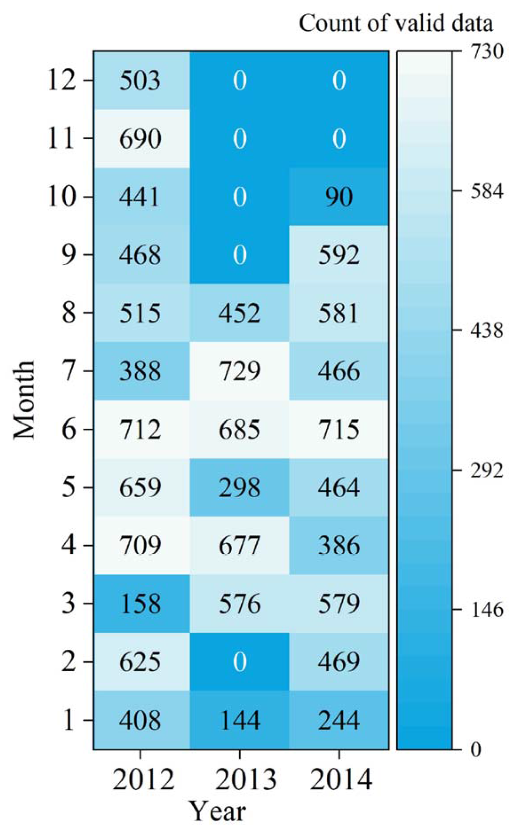
Figure 2Count of valid hourly measurements of TGM per month at Nam Co Station. Source: Yin et al. (2018).
At Tanglha Station, TGM exhibited a clear decreasing trend during the growing season: emergence period (2.32 ± 0.51 ng m−3) > active growth (2.01 ± 0.25 ng m−3) > peak vegetation (1.80 ± 0.26 ng m−3) (Sun et al., 2020b; APCC dataset I-1). Higher TGM during emergence was associated with enhanced land-air Hg emissions. A subsequent increase during the ISM period coincided with strengthened westerlies (Sun et al., 2020b). Autumn TGM (2.11 ± 0.25 ng m−3) reached levels similar to the emergence phase, despite lower terrestrial fluxes, suggesting limited ISM-transported Hg influence inland (Sun et al., 2020b). This pattern contrasts with summer maxima observed at southern Tibetan sites (Yin et al., 2018).
Land-air Hg fluxes decreased logarithmically during the growing season-from 3.47 ± 4.39 ng m−2 h−1 (emergence) to near zero (peak vegetation; APCC dataset I-1), primarily due to vegetation shading suppressing soil emissions. Plant uptake played a minor role given the sparse biomass (Sun et al., 2020b). Surface emissions represent a major TGM source across the remote Tibetan Plateau, where anthropogenic impacts are negligible (Sun et al., 2020b).
4.2 Hg from aerosol
Measurements of HgP on TSP were conducted at multiple stations across the Third Pole as part of the Atmospheric Pollution and Cryospheric Change (APCC dataset I-2). In the Taklimakan Desert, HgP concentrations ranged from 224.4 to 257.1 pg m−3, markedly higher than those observed at typical Chinese background sites. A distinct seasonal peak occurred during frequent dust storm episodes from March to August (Huang et al., 2020b). Preliminary emission estimates indicate that atmospheric dust originating from this region could export Hg at a rate of 59.7 ± 60.3 Mg yr−1 (Huang et al., 2020b).
At the high-altitude Lhasa Station, HgP concentrations varied widely from 61.2 to 831 pg m−3, with a mean value of 224 pg m−3, comparable to levels recorded in heavily polluted Chinese megacities (Huang et al., 2016). Dry deposition was identified as the dominant process in the local Hg cycle, with an estimated flux of 35.3 µg m−2 yr−1, significantly exceeding the wet deposition flux of 8.2 µg m−2 yr−1.
In the Kathmandu Valley, HgP levels were exceptionally high, averaging 850.5 ± 962.8 pg m−3, which was among the highest reported for urban areas globally (Guo et al., 2017). Concentrations exhibited strong seasonality, with elevated values during winter and pre-monsoon periods. The corresponding dry deposition flux reached 135 µg m−2 yr−1. Similarly, at LMB on the Indo-Gangetic Plains, HgP concentrations (range: 6.8–351.7 pg m−3; mean: 99.7 ± 92.6 pg m−3) exceeded those at most remote global sites. Consistently higher values were observed during the dry season compared to the wet season (Guo et al., 2022), with an estimated dry deposition flux of 15.7 µg m−2 yr−1.
4.3 Hg from precipitation
Precipitation Hg measurements from multiple stations across the Third Pole reveal distinct spatial and temporal patterns (APCC dataset I-3). At Nam Co station, mean HgT concentrations measured 4.8 ng L−1 with a clear seasonal pattern showing two-fold higher levels during non-monsoon periods compared to monsoon seasons (Huang et al., 2012a). Despite lower concentrations, monsoon rainfall accounted for 83 ± 5 % of annual wet deposition fluxes, demonstrating precipitation-driven scavenging efficiency. Speciation analysis showed HgP dominated precipitation HgT (71.2 %), with MeHg constituting 1.82 % of HgT.
The Lhasa station exhibited significantly higher HgT concentrations (24.8 ng L−1) with different deposition dynamics (Huang et al., 2013). Here, HgT wet deposition flux was primarily concentration-driven rather than precipitation-dependent as observed at Nam Co. Seasonal variations showed higher HgT and HgP concentrations during non-monsoon periods, while reactive Hg (HgR) in precipitation peaked during monsoon seasons. Speciation indicated HgP accounted for 77 % of HgT, with HgR representing only 5 %.
In Southeast Tibet station, while mean HgT concentration (4.0 ng L−1) was relatively low, MeHg levels (0.112 ng L−1) and deposition flux (0.11 µg m−2 yr−1) were among the highest reported globally (Huang et al., 2015). HgD emerged as the dominant species, suggesting significant contributions from gaseous oxidized Hg scavenging.
Expanded monitoring precipitation stations in both monsoon and westerlies domains across the Third Pole revealed contrasting regional patterns (Huang et al., 2022). The westerlies domain showed higher HgT concentrations and HgP percentages (Fig. 4a), while the monsoon domain exhibited greater wet Hg deposition fluxes (Fig. 4b). Extreme values were recorded at Motuo station in the Yarlung Tsangpo Grand Canyon (56.3 ng L−1 HgT concentration, 84.7 µg m−2 yr−1 flux) (Huang et al., 2024).
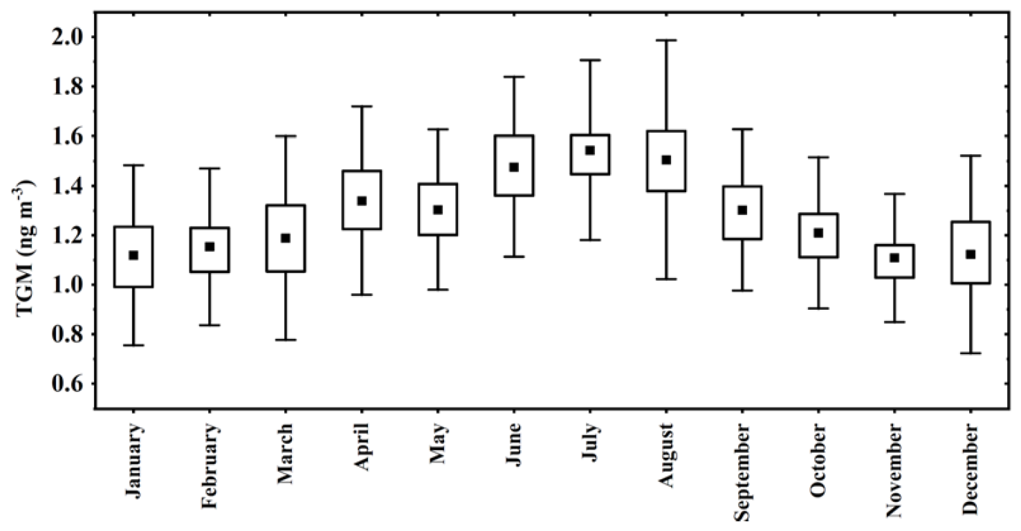
Figure 3Monthly average of TGM at Nam Co Station during the whole measurement period. Source: Yin et al. (2018).
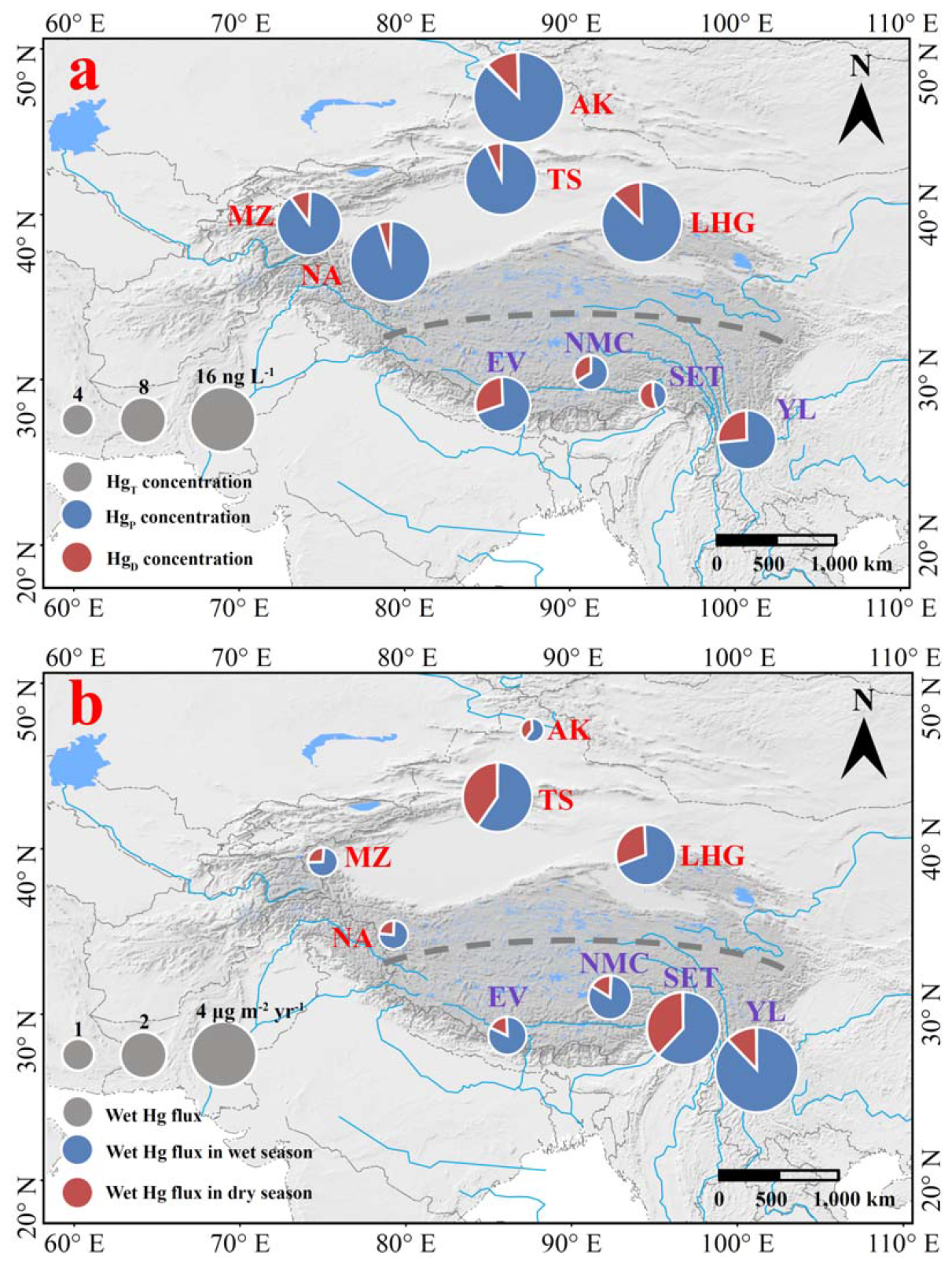
Figure 4Spatial distribution of precipitation Hg concentration (a) and wet Hg deposition flux (b) between the monsoon and westerlies domains over the Third Pole (Acronyms are as same as Table 1). Source: Huang et al. (2022).
Nepal Himalayan measurements demonstrated strong spatial gradients, with Kathmandu showing urban-level Hg concentrations (34.91 µg m−2 yr−1 flux) compared to background sites like Dhunche (15.89 µg m−2 yr−1) (Tripathee et al., 2019). All sites exhibited pronounced seasonal variability, with higher concentrations during non-monsoon periods (Tripathee et al., 2019, 2020).
4.4 Hg from glacier
Systematic snowpit surveys conducted at 9 of the 12 glaciers (Fig. 1 and Table 2) between 2005–2010 revealed total Hg concentrations ranging from below detection limit (< 1 ng L−1) to 43.6 ng L−1 across all sampling sites (APCC dataset I-4; Fig. 5; Zhang et al., 2012). The seasonal amplitude of Hg concentrations showed winter maxima averaging 28.3 ± 8.7 ng L−1 compared to summer minima of 5.2 ± 3.1 ng L−1 (n=9). Spatial distribution patterns indicated 35 %–42 % higher concentrations in northern glaciers (Xiao Dongkemadi, Laohugou No.12) relative to southern sites (East Rongbuk, Zhadang) (Figs. 1 and 4). Corresponding annual deposition fluxes varied from 0.74 ± 0.21 to 7.89 ± 2.34 µg m−2 yr−1 across different glaciers (Zhang et al., 2012).
Detailed analysis of July 2013 samples from Laohugou Glacier No. 12 (northeastern Tibetan Plateau) demonstrated HgP accounted for 82 ± 11 % of total Hg in snow/ice matrices (APCC dataset I-4; Huang et al., 2014b). Vertical snowpit profiles (n=5) exhibited consistent Hg enrichment patterns, with concentration increasing from 3.2 ± 1.1 ng L−1 in surface layers to 18.6 ± 5.3 ng L−1 at 1.8 m depth (Huang et al., 2014b).
Surface snow sampling campaigns during 2008–2010 covered 4 high-altitude glaciers (East Rongbuk: 6350 m; Zhadang: 5800 m; Ganglongjiama: 5600 m; Muztagata: 4900 m), with mean elevation of 5200 ± 620 m (APCC dataset I-4; Huang et al., 2012b). Measured Hg concentrations showed site-specific variations: Mt. Muztagata (range: 2.1–15.0 ng L−1; mean: 8.56 ± 3.72 ng L−1) consistently displayed higher values than Mt. Nyainqêntanglha (0.9–3.2 ng L−1; mean: 1.8 ± 0.7 ng L−1). Mass balance calculations indicated 31 ± 9 % of initially deposited Hg was lost during snow metamorphosis processes (Huang et al., 2012b).
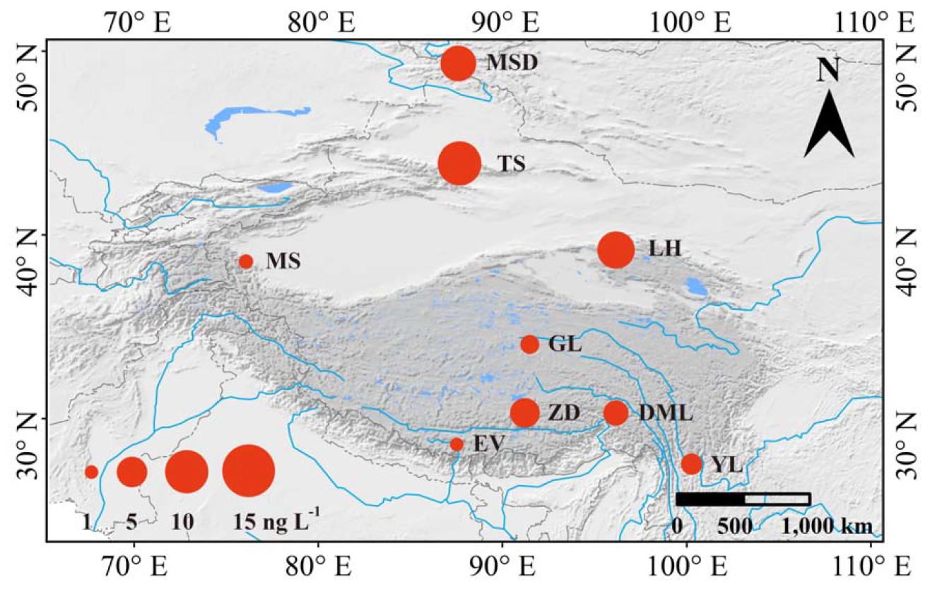
Figure 5The red circle shows the location of the glacier sampling sites over the Third Pole, while its area represents the average HgT concentrations from the glacier snowpits (Acronyms are as same as Table 1). Source: Zhang et al. (2012).
Cryoconite samples collected from 7 glaciers (n=112) revealed distinct spatial patterns in Hg accumulation (APCC dataset I-4; Huang et al., 2019). Southern glaciers influenced by monsoon circulation (East Rongbuk, Ganglongjiama) showed higher mean Hg concentrations (66.0 ± 29.3 ng g−1; range: 22–143 ng g−1) compared to westerlies-dominated northern glaciers (Laohugou No.12, Muztagata: 42.5 ± 20.7 ng g−1; range: 15–89 ng g−1) (t-test, p < 0.05). MeHg was detected in all cryoconite samples (n=112), with concentrations ranging from 0.3 to 2.1 ng g−1 (overall mean: 1.0 ± 0.4 ng g−1) (Huang et al., 2019). Elevation-dependent trends exhibited contrasting correlations between northern and southern glacier sites, with northern regions showing a decreasing trend and southern regions displaying an increasing trend with elevation.
4.5 Hg from soil
Comprehensive soil sampling (n=336) was conducted across 28 locations representing meadow (n = 84), grassland (n = 112), desert (n = 92), and forest (n = 48) ecosystems, covering an elevation range of 2917–4762 m across the Tibetan Plateau (Fig. 6). Hg concentrations showed considerable variability, ranging from 2.1 to 200.3 ng g−1 with an overall arithmetic mean of 31.8 ng g−1 (geometric mean: 22.4 ng g−1) (APCC dataset I-5; Yin et al., 2024). Among ecosystem types, forest soils consistently exhibited the highest concentrations (range: 18.6–200.3 ng g−1; mean: 74.4 ng g−1), followed by meadow (mean: 29.2 ng g−1), grassland (mean: 25.7 ng g−1), and desert ecosystems (mean: 12.8 ng g−1). Spatial interpolation analysis revealed a clear southeast-to-northwest decreasing gradient, with maximum values clustered in southeastern forested regions (Fig. 6; Yin et al., 2024).
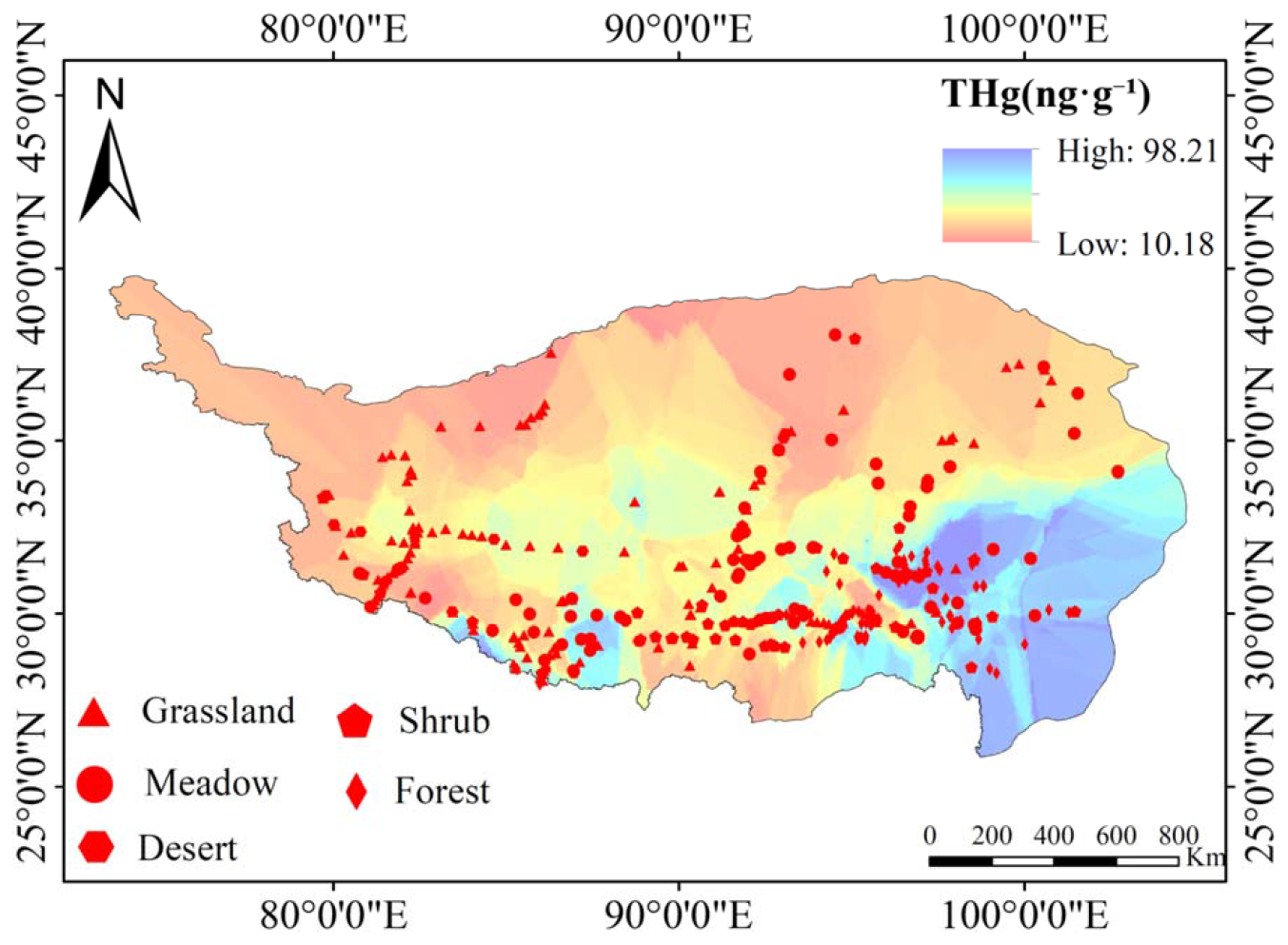
Figure 6Spatial distribution of topsoil HgT concentrations across the Tibetan Plateau. The map, based on 336 topsoil samples from meadow, grassland, desert, and forest ecosystems, reveals a distinct southeast-to-northwest decreasing gradient, with the highest concentrations in the southeastern forested regions. Source: Yin et al. (2024).
Along a 1200 km southwest-northeast transect across the Himalaya-Tibet region, soil Hg analysis of 31 samples showed distinct spatial variation (Huang et al., 2020b). Southern slope soils (n = 21) displayed higher and more variable concentrations (range: 15–189 ng g−1; mean ± SD: 72 ± 54 ng g−1) compared to northern slopes (n = 10; range: 12–89 ng g−1; mean ± SD: 43 ± 26 ng g−1) (t-test, p < 0.05) (Huang et al., 2020b). In the central Himalayas (Langtang region), soil Hg measurements (n = 45) averaged 35.75 ± 24.41 ng g−1 (range: 8.2–112.3 ng g−1), with a consistent negative correlation between concentration and elevation (, p < 0.01) across the 3800–5200 m altitude range (Tripathee et al., 2018).
The Central Asia topsoil survey (0–10 cm depth) encompassed 182 sampling sites across three countries (Tajikistan: n = 67; Uzbekistan: n = 72; Kyrgyzstan: n = 43), representing five land use types (Fig. 7a). Hg concentrations showed extreme variability (1.6–908 ng g−1), with urban areas exhibiting both the highest maximum values and greatest variability (range: 8.6–908 ng g−1; mean ± SD: 79.8 ± 112.3 ng g−1). Other land types showed progressively lower mean concentrations: woodland (n = 38; 27.3 ± 18.4 ng g−1), grassland (n = 52; 20.6 ± 12.7 ng g−1), farmland (n = 29; 18.3 ± 9.8 ng g−1), and desert (n = 23; 12.3 ± 6.5 ng g−1) (APCC dataset I-5; Yang et al., 2023). The spatial distribution showed clear hotspots in capital city regions, with 12 urban samples exceeding 200 ng g−1 (Fig. 7b).
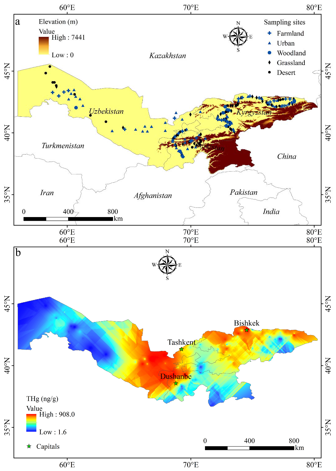
Figure 7(a) Topsoil sampling sites and (b) spatial distribution of HgT concentrations in topsoils (0–10 cm) across Central Asia. Results from 182 sites show extreme variability (1.6–908 ng g−1), with pronounced urban hotspots-particularly in capital cities-driving the spatial distribution pattern. Source: Z. Yang et al. (2023).
4.6 Hg from surface water
Available surface water Hg measurements from various aquatic systems across the Third Pole, including lakes, rivers, and glacial meltwater, are summarized in Fig. 8. In the Yarlung Zangbo River basin, surface water samples collected from 17 sites along the upper/middle reaches and tributaries (Lhasa and Niyang rivers) showed HgT concentrations ranging from 1.46 to 4.99 ng L−1 (Zheng et al., 2010). Seasonal sampling in the Koshi River basin, significantly influenced by the South Asian monsoon, revealed HgT concentrations varying between 0.64 and 32.96 ng L−1 (mean: 5.83 ± 6.19 ng L−1), with the highest values consistently observed during post-monsoon periods (Sun et al., 2020c). HgP accounted for more than 50 % of HgT, particularly during and after monsoon seasons, indicating its dominant role in seasonal and spatial Hg variations.
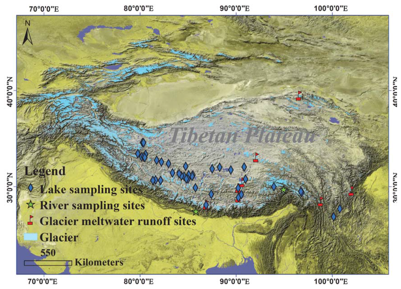
Figure 8Sampling sites and compiled measurements of HgT in surface waters (rivers, lakes, glacier runoffs) across the Third Pole. Data in Sect. 4.6 reveal a northwest-southeast increasing gradient in lakes, seasonal peaks in post-monsoon rivers with HgP as the dominant form, and generally low but temporally variable HgT in glacial meltwater, influenced by ablation intensity and downstream processes.
Surface water samples from 42 Tibetan Plateau lakes exhibited HgT concentrations ranging from < 1 to 40.3 ng L−1 (APCC dataset I-6; Li et al., 2015; Paudyal et al., 2019; Sun et al., 2023). The spatial distribution revealed a distinct northwest-southeast gradient, with higher concentrations generally observed in northwestern regions (t-test, p < 0.05) (Li et al., 2015). This comprehensive dataset provides valuable baseline information on Hg distribution patterns across different aquatic ecosystems in the Third Pole, documenting both spatial gradients and seasonal variations while maintaining focus on observational evidence.
Glacial meltwater measurements from 9 glacier runoffs (Laohugou No.12, Zhadang, Xiao Dongkemadi, Kuqionggangri, Qiangyong, Hailuogou, East Rongbu, Mingyong and Baishuihe No.1) during ablation periods showed HgT concentrations generally below background levels, with peaks occurring during maximum melt periods (APCC dataset I-6). Some sites, such as Laohugou No.12, occasionally exceeded 100 ng L−1 (Wang et al., 2024). Downstream sampling at Zhadang glacier demonstrated increasing Hg transport with meltwater flow (Sun et al., 2017, 2018), while monthly observations at Rongbuk, Laohugou No.12, and Mingyong glaciers revealed temporal variations correlated with ablation intensity (Sun et al., 2022; Wang et al., 2022; Pu et al., 2024). The Qiangyong glacier basin showed a 20 % decrease in HgT concentrations between proglacial lake inflow and outflow (APCC dataset I-6; Sun et al., 2016), suggesting lake systems may act as effective sinks for Hg transported by glacial meltwater.
4.7 Hg from glacier ice core and lake sediment cores
The Ganglongjiama (Guoqu) glacier ice core from Mt. Geladaindong provides a 500-year record of atmospheric Hg deposition, with concentrations ranging from < 0.1 to 9.8 ng L−1 (mean: 0.84 ng L−1) (APCC dataset I-7; Kang et al., 2016). Calculated deposition fluxes reveal distinct temporal patterns, with an overall mean of 0.36 µg m−2 yr−1, increasing from 0.28 µg m−2 yr−1 in the pre-industrial period to 0.91 µg m−2 yr−1 in the post-WWII era (Fig. 9). These values are consistent with measurements from other Tibetan Plateau glaciers (Loewen et al., 2007; Zhang et al., 2012).
Lake sediment records demonstrate significant spatial variability across the Himalayas. Northern slope lakes (Fig. 10; Qiangyong Co, Nam Co, Bangong Co, Lingge Co, Tanglha Lake) exhibit mean Hg concentrations of 36 ng g−1 (range: 7.6–119.8 ng g−1), while southern slope lakes (Fig. 11; Phewa, Gokyo, Gosainkunda) show higher values (mean: 103 ng g−1; range: 6–647.7 ng g−1) (t-test, p < 0.05) (Table 3). Post-WWII accumulation rates follow a similar pattern, with northern lakes averaging 14.6 µg m−2 yr−1 compared to 112.1 µg m−2 yr−1 in southern lakes (APCC dataset I-7; Kang et al., 2016).
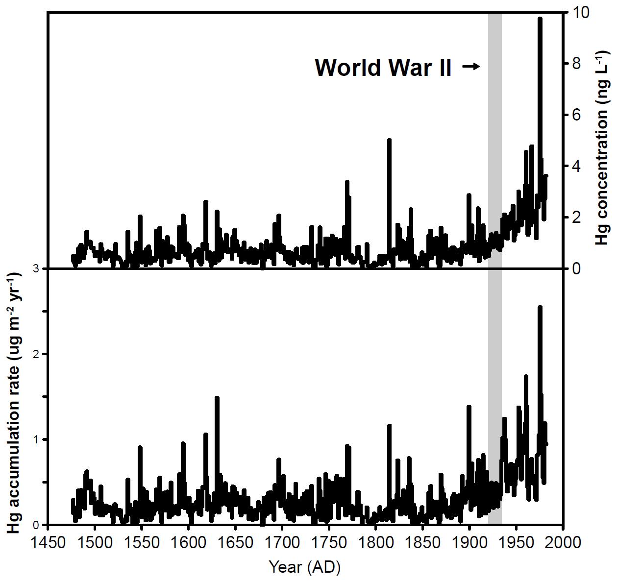
Figure 9Historical trends of concentration and accumulation rate of Hg reconstructed from the Geladaindong ice core (contours indicate the year-by-year variability; gray bar represents the World War II period). Source: Kang et al. (2016).
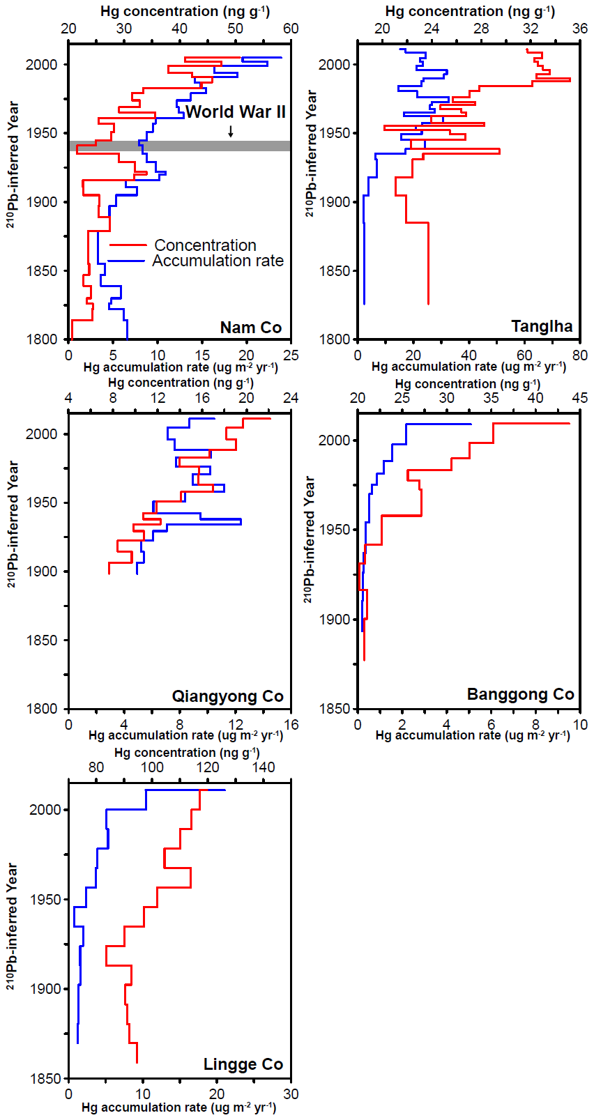
Figure 10Hg concentration and accumulation rate profiles of the sediment cores taken from five lakes (Qiangyong Co, Nam Co, Bangong Co, Lingge Co, and Tanglha Lake) in the northern slopes of the Himalayas. Gray bar represents the World War II period. Source: Kang et al. (2016).
The combined records document three temporal phases: (1) stable background levels (1500s–early 1800s), (2) initial increases (late 1800s), and (3) accelerated accumulation post-WWII (Figs. 8–10). Southern slope sediments consistently show 4-fold higher Hg concentrations and 8-fold greater deposition fluxes than northern counterparts (t-test, p < 0.05) (APCC dataset I-7; Kang et al., 2016). These patterns are preserved across different environmental archives, providing robust evidence of spatial and temporal variations in Hg deposition across the Himalayan region.
The ice core was dated using annual layer counting (δ18O, dust, ions), a 3H peak (1963 AD), 210Pb, volcanic markers, and a flow model, with uncertainties of ±1 years (since 1963 AD), ±5 years (since 1872 AD), ±10 years (since 1600 AD), and ±20 years (back to 1477 AD). Hg fluxes are derived from measured Hg concentrations and accumulation rates (from the age depth model and ice density); sediment cores were dated by 210Pb (CRS model), and all age depth models, uncertainties, accumulation rates, and flux calculations are documented in Kang et al. (2016).
4.8 Hg stable isotopes from aerosol, soil and lake sediment
Hg isotope measurements (δ202Hg, Δ199Hg, Δ200Hg) from various environmental media in the Third Pole provide insights into Hg sources and transport processes (Blum et al., 2014). Atmospheric aerosols in the Kathmandu Valley show δ202Hg values ranging from −1.42 ‰ to 0.28 ‰ (mean: −0.82 ‰) and Δ202Hg from −0.30 ‰ to −0.12 ‰ (mean: −0.16 ‰) (APCC dataset I-8; Guo et al., 2021). Seasonal variations were observed at LMB, with distinct isotopic signatures between pre-monsoon and monsoon periods (Guo et al., 2022). This dataset reveals that local dust resuspension and combustion sources, rather than long-range transport alone, dominate PBM in Nepal, providing a critical baseline for regional Hg cycling.
Soil samples reveal a marked north-south contrast, with southern Himalayan slopes exhibiting lower mean δ202Hg values (−0.53 ‰) compared to northern slopes (−0.12 ‰) (APCC dataset I-8; Huang et al., 2020b, 2020c). Negative Δ199Hg values in most soils indicate widespread gaseous Hg° deposition, while sporadic positive odd-MIF suggests local precipitation-sourced Hg (Huang et al., 2020b, c). Lake sediment cores from 4 lakes along a southwest-northeast transect show positive Δ199Hg (0.07 ‰–0.44 ‰) and Δ200Hg (0.03 ‰–0.08 ‰) values (APCC dataset I-8; Huang et al., 2023). The Δ199Hg values peak at Tanglha Lake (0.44 ‰) before decreasing further northeast, suggesting a southwest-northeast gradient in isotopic composition. This dataset provides evidence that transboundary atmospheric transport delivers Hg from South Asia northward to at least the Tanglha Mountains in the northern Himalaya-Tibet.
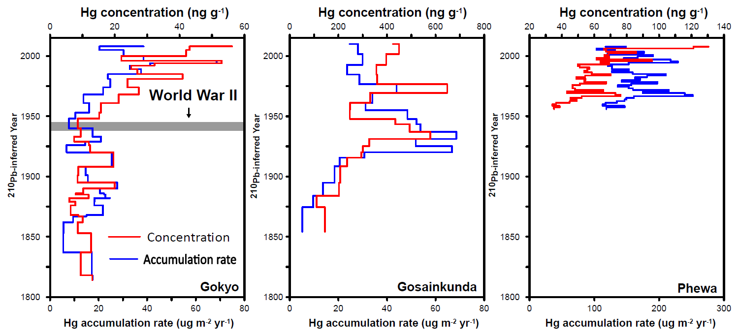
Figure 11Hg concentration and accumulation rate profiles of the sediment cores taken from three lakes (Phewa, Gokyo, and Gosainkunda Lake) in the southern slopes of the Himalayas. Gray bar represents the World War II period. Source: Kang et al. (2016).
The Third Pole Hg dataset has inherent spatial and temporal limitations. Specifically, atmospheric Hg monitoring is restricted to two inland stations (Nam Co and Tanggula); historical reconstruction relies on a single ice core from the central Tibetan Plateau; and several media (e.g., aerosols, precipitation) are sampled at discrete locations that cannot fully capture the region's strong environmental heterogeneity. Due to extreme climatic conditions, unreliable power supply, and logistical constraints, measurements are short-term, sporadic, and temporally inconsistent across sites and seasons, which precludes long-term or synchronous multi-site monitoring. Nevertheless, the data robustly support site-specific and comparative analyses across distinct climatic regimes (monsoon vs. westerlies, northern vs. southern slopes) and along altitudinal/transboundary gradients. For example, the north-south contrast can provide key evidence for assessing transboundary pollutant transport. Regional extrapolation requires caution, but future expansion of the monitoring network and improvement of spatial coverage will gradually reduce current uncertainties.
Recommended uses include seasonal and inter-annual variability analysis and model evaluation for atmospheric Hg (Nam Co, Tanggula), which are particularly useful for testing Hg concentration trends in atmospheric chemical transport models; wet deposition-flux estimation from precipitation data, which is a fundamental basis for assessing atmospheric Hg input; regional spatial comparisons using glacier snowpits (12 glaciers) and lake sediment cores (8 lakes) to reveal Hg distribution patterns along environmental gradients; historical trend reconstruction and source attribution using Hg isotopes (δ202Hg, Δ199Hg etc.) from ice cores and sediment cores, helping to distinguish natural background from anthropogenic contributions; spatial contrast and mixing assessment (natural vs. anthropogenic) for soils; and seasonal baseline establishment for river and lake water to provide background reference for aquatic Hg dynamics. In contrast, the following uses are not recommended regional extrapolation of absolute fluxes (due to sparse site coverage and strong environmental heterogeneity); long-term trend detection for short-term media such as aerosols, precipitation, and snow (limited and discontinuous time series); synoptic multi-site comparison across the entire plateau (non-synchronous sampling at different sites); quantitative source apportionment using only Hg isotopes without local contextual knowledge (insufficient spatial isotope coverage); and direct cross-matrix comparison (e.g., cryoconite in ng g−1 vs. snow in ng L−1-different matrices and units, not directly comparable). Users are strongly advised to consult the metadata files and README documentation for each subset to ensure proper application of the data.
The APCC dataset (v1.0) is archived at the Cold and Arid Regions Science Data Center at Lanzhou, released on 3 December 2024 with the persistent DOI https://doi.org/10.12072/ncdc.qzkk.db6654.2024 (Kang et al., 2024). This dataset is available under the CC BY 4.0 International License and will be updated annually with newly acquired Hg concentration and deposition observations over the Third Pole. All raw field measurements, quality-controlled intermediate data, and summary statistics necessary to reproduce all manuscript figures and tables are fully deposited in the repository. No proprietary or restricted datasets were employed in this work, ensuring full reproducibility of all results.
A specific directory was designated with data classified into different categories:
- a.
Real-time atmospheric Hg observation data (APCC dataset I-1),
- b.
Aerosol Hg data (APCC dataset I-2),
- c.
Precipitation Hg data (APCC dataset I-3),
- d.
Glacier (snowpit, surface snow, cryoconite) Hg data (APCC dataset I-4),
- e.
Soil Hg data (APCC dataset I-5),
- f.
River and lake water Hg data (APCC dataset I-6),
- g.
Ice core Hg data (APCC dataset I-7),
- h.
Lake sediment core Hg data (APCC dataset I-8),
- i.
Hg isotope data from aerosols, soils and lake sediments (APCC dataset I-9).
Based on the APCC program, a comprehensive Hg dataset has been assembled across the Third Pole. This study compiles measurements from diverse environmental matrices-including air, aerosols, precipitation, glaciers, soils, surface water, glacier ice and lake sediment cores-encompassing Hg speciation, concentrations, fluxes, and isotopic compositions. The dataset represents a coordinated effort to address key scientific objectives, which include: (1) characterizing spatial, seasonal, and long-term variations of Hg across different environmental compartments in the Third Pole; (2) elucidating the processes and mechanisms governing transboundary transport and long-range deposition of atmospheric Hg into the region; (3) apportioning sources of atmospheric Hg using chemical tracers and modeling approaches, and identifying the fate of Hg within environmental media; and (4) improving predictions of Hg cycling in cryospheric environments and evaluating its impacts under rapid climate warming and cryospheric shrinking. This information is essential for risk assessment and mitigation of Hg pollution at both global and regional scales, and provides scientific support for policy formulation.
| TSP | Total Suspended Particulates |
| TGM | Total Gaseous Mercury |
| ISM | Indian Summer Monsoon |
| HgT or THg | Total Hg |
| HgP or PHg | Particulate-bound Hg |
| HgD or DHg | Dissolved Hg |
| HgR or RHg | Reactive Hg |
| MeHg | Methyl Hg |
SK, JH, QZ, JG, XY, SS, XS, LT, AS, WT, YZ, XM, LL and LC led the writing of the manuscript and endorsed the responsibility of experimental sites and instruments. SK and JH originally drafted the manuscript, and all of the authors contributed to the paper writing and data preparation. SK and JH led the consolidation of the dataset and prepared the data in the standardized format described in this paper together with all co-authors.
The contact author has declared that none of the authors has any competing interests.
Publisher's note: Copernicus Publications remains neutral with regard to jurisdictional claims made in the text, published maps, institutional affiliations, or any other geographical representation in this paper. The authors bear the ultimate responsibility for providing appropriate place names. Views expressed in the text are those of the authors and do not necessarily reflect the views of the publisher.
Hg research team members in our research group (led by Shichang Kang) are greatly appreciated for their efforts in participating field observations, maintaining the instruments, and analysing the samples in the laboratory.
This work was supported by the National Natural Science Foundation of China (grant nos. 42277397, 42571171), the Key Science and Technology Plan Project of Lhasa (Grant no. LSKJ202410), and Science and Technology projects of Xizang Autonomous Region, China (grant nos. XZ202401ZY0068, XZ202501ZY0078).
This paper was edited by Dalei Hao and reviewed by four anonymous referees.
Beckers, F. and Rinklebe, J.: Cycling of mercury in the environment: Sources, fate, and human health implications: A review, Crit. Rev. Env. Sci. Tec., 47, 693–794, https://doi.org/10.1080/10643389.2017.1326277, 2017.
Bergquist, B. A. and Blum, J. D.: Mass-dependent and-independent fractionation of Hg isotopes by photoreduction in aquatic systems, Science, 318, 417–420, https://doi.org/10.1126/science.1148050, 2007.
Blum, J. D., Sherman, L. S., and Johnson, M. W.: Mercury isotopes in earth and environmental sciences, Annu. Rev. Earth Planet. Sci. 42, 249–269, https://doi.org/10.1146/annurev-earth-050212-124107, 2014.
Chen, D., Xu, B., Yao, T., Guo, Z., Cui, P., Chen, F., Zhang, R., Zhang, X., Zhang, Y., Fan, J., Hou, Z., and Zhang, T.: Assessment of past, present and future environmental changes on the Tibetan Plateau, Chin. Sci. Bull., 60, 3025–3035, https://doi.org/10.1360/N972014-01370, 2015.
de Foy, B., Tong, Y., Yin, X., Zhang, W., Kang, S., Zhang, Q., Zhang, G., Wang, X., and Schauer, J. J.: First field-based atmospheric observation of the reduction of reactive mercury driven by sunlight, Atmos. Environ., 134, 27–39, https://doi.org/10.1016/j.atmosenv.2016.03.028, 2016.
Driscoll, C. T., Mason, R. P., Chan, H. M., Jacob, D. J., and Pirrone, N.: Mercury as a global pollutant: sources, pathways, and effects, Environ. Sci. Technol., 47, 4967–4983, https://doi.org/10.1021/es305071v, 2013.
Grandjean, P., Satoh, H., Murata, K., and Eto, K.: Adverse effects of methylmercury: Environmental health research implications, Environ. Health Persp., 118, 1137–1145, https://doi.org/10.1289/ehp.0901757, 2010.
Guo, J., Kang, S., Huang, J., Zhang, Q., Rupakheti, M., Sun, S., Tripathee, L., Rupakheti, D., Panday, A. K., and Sillanpää, M.: Characterizations of atmospheric particulate-bound mercury in the Kathmandu Valley of Nepal, South Asia, Sci. Total Environ., 579, 1240–1248, https://doi.org/10.1016/j.scitotenv.2016.11.110, 2017.
Guo, J., Sharma, C. M., Tripathee, L., Kang, S., Fu, X., Huang, J., Shrestha, K. L., and Chen, P.: Source identification of atmospheric particle-bound mercury in the Himalayan foothills through non-isotopic and isotope analyses, Environ. Pollut., 286, 117317, https://doi.org/10.1016/j.envpol.2021.117317, 2021.
Guo, J., Tripathee, L., Kang, S., Zhang, Q., Huang, J., Mani Sharma, C., Chen, P., Paudyal, R., and Rupakheti, D.: Atmospheric particle-bound mercury in the northern Indo-Gangetic Plain region: Insights into sources from mercury isotope analysis and influencing factors, Geosci. Front., 13, 101274, https://doi.org/10.1016/j.gsf.2021.101274, 2022.
Huang, J., Kang, S., Zhang, Q., Yan, H., Guo, J., Jenkins, M. G., Zhang, G., and Wang, K.: Wet deposition of mercury at a remote site in the Tibetan Plateau: Concentrations, speciation, and fluxes, Atmos. Environ., 62, 540–550, https://doi.org/10.1016/j.atmosenv.2012.09.003, 2012a.
Huang, J., Kang, S., Zhang, Q., Jenkins, M., Guo, J., Zhang, G., and Wang, K.: Spatial distribution and magnification processes of mercury in snow from high-elevation glaciers in the Tibetan Plateau, Atmos. Environ., 46, 140–146, https://doi.org/10.1016/j.atmosenv.2011.10.008, 2012b.
Huang, J., Kang, S., Wang, S., Wang, L., Zhang, Q., Guo, J., Wang, K., Zhang, G., and Tripathee, L.: Wet deposition of mercury at Lhasa, the capital city of Tibet, Sci. Total Environ. 447, 123–132, https://doi.org/10.1016/j.scitotenv.2013.01.003, 2013.
Huang, J., Kang, S., Guo, J., Sillanpää, M., Zhang, Q., Qin, X., Du, W., and Tripathee, L.: Mercury distribution and variation on a high-elevation mountain glacier on the northern boundary of the Tibetan Plateau, Atmos. Environ., 96, 27–36, https://doi.org/10.1016/j.atmosenv.2014.07.023, 2014b.
Huang, J., Kang, S., Zhang, Q., Guo, J., Sillanpää, M., Wang, Y., Sun, S., Sun, X., and Tripathee, L.: Characterizations of wet mercury deposition on a remote high-elevation site in the southeastern Tibetan Plateau, Environ. Pollut., 206, 518–526, https://doi.org/10.1016/j.envpol.2015.07.024, 2015.
Huang, J., Kang, S., Guo, J., Zhang, Q., Cong, Z., Sillanpää, M., Zhang, G., Sun, S., and Tripathee, L.: Atmospheric particulate mercury in Lhasa city, Tibetan Plateau, Atmos. Environ., 142, 433–441, https://doi.org/10.1016/j.atmosenv.2016.08.021, 2016.
Huang, J., Kang, S., Ma, M., Guo, J., Cong, Z., Dong, Z., Yin, R., Xu, J., Tripathee, L., Ram, K., and Wang, F.: Accumulation of atmospheric mercury in glacier cryoconite over western China, Environ. Sci. Technol., 53, 6632–6639, https://doi.org/10.1021/acs.est.8b06575, 2019.
Huang, J., Kang, S., Yin, R., Ram, K., Liu, X., Lu, H., Guo, J., Chen, S., and Tripathee, L.: Desert dust as a significant carrier of atmospheric mercury, Environ. Pollut., 267, 115442, https://doi.org/10.1016/j.envpol.2020.115442, 2020a.
Huang, J., Kang, S., Yin, R., Guo, J., Lepak, R., Mika, S., Tripathee, L., and Sun, S.: Mercury isotopes in frozen soils reveal transboundary atmospheric mercury deposition over the Himalayas and Tibetan Plateau, Environ. Pollut., 256, 113432, https://doi.org/10.1016/j.envpol.2019.113432, 2020b.
Huang, J., Kang, S., Yin, R., Lin, M., Guo, J., Ram, K., Li, C., Sharma, C., Tripathee, L., Sun, S., and Wang, F.: Decoupling natural and anthropogenic mercury and lead transport from South Asia to the Himalayas. Environ. Sci. Technol., 54, 5429–5436, 2020c.
Huang, J., Kang, S., Wang, L., Liu, K., Ram, K., Sillanpää, M., Tang, W., Guo, J., Zhang, Q., Ma, M., Tripathee, L., and Wang, F.: Anthropogenic and natural drivers of seesaw-like spatial patterns in precipitation mercury over western China, Environ. Pollut., 307, 119525, https://doi.org/10.1016/j.envpol.2022.119525, 2022.
Huang, J., Kang, S., Feng, X., Tang, W., Ram, K., Guo, J., Zhang, Q., Sharma, C. M., Li, C., Tripathee, L., and Wang, F.: Northward extent of atmospheric mercury transboundary transport to the Himalayas and Tibetan Plateau Region, Geophys. Res. Lett., 50, e2022GL100948, https://doi.org/10.1029/2022GL100948, 2023.
Huang, J., Zhang, Y., Kang, S., Tang, W., Liu, J., Liu, K., Wang, L., Guo, J., Tripathee, L., and Zhao, W.: Unexpectedly high wet mercury deposition observed in the Yarlung Tsangpo Grand canyon, Appl. Geochem., 175, 106175, https://doi.org/10.1016/j.apgeochem.2024.106175, 2024.
Huang, Q., Liu, Y., Chen, J., Feng, X., Huang, W., Yuan, S., Cai, H., and Fu, X.: An improved dual-stage protocol to pre-concentrate mercury from airborne particles for precise isotopic measurement, J. Anal. At. Spectrom., 30, 957–966, https://doi.org/10.1039/C4JA00438H, 2015.
Immerzeel, W. W., Van Beek, L. P., and Bierkens, M. F.: Climate change will affect the Asian water towers, Science, 328, 1382–1385, https://doi.org/10.1126/science.1183188, 2010.
Kang, S., Xu, Y., You, Q., Flügel, W. A., Pepin, N., and Yao, T.: Review of climate and cryospheric change in the Tibetan Plateau, Environ. Res. Lett., 5, 015101, https://doi.org/10.1088/1748-9326/5/1/015101, 2010.
Kang, S., Huang, J., Wang, F., Zhang, Q., Zhang, Y., Li, C., Wang, L., Chen, P., Sharma, C. M., and Li, Q.: Atmospheric mercury depositional chronology reconstructed from lake sediments and ice core in the Himalayas and Tibetan Plateau, Environ. Sci. Technol., 50, 2859–2869, https://doi.org/10.1021/acs.est.5b04172, 2016.
Kang, S., Zhang, Q., Qian, Y., Ji, Z., Li, C., Cong, Z., Zhang, Y., Guo, J., Du, W., Huang, J., You, Q., Panday, A. K., Rupakheti, M., Chen, D., Gustafsson, Ö., Thiemens, M. H., and Qin, D.: Linking atmospheric pollution to cryospheric change in the Third Pole region: current progress and future prospects, Natl. Sci. Rev., 6, 796–809, https://doi.org/10.1093/nsr/nwz031, 2019.
Kang, S., Huang, J., Zhang, Q., Guo, J., Yin, X., Sun, S., and Sun, X.: Mercury Dataset of the Third Pole (2010–2023), National Cryosphere Desert Data Center [data set], https://doi.org/10.12072/ncdc.qzkk.db6654.2024, 2024.
Kessler, R.: The Minamata Convention on Mercury: a first step toward protecting future generations. Environ. Health Persp., 121, A304–A309, https://doi.org/10.1289/ehp.121-A304, 2013.
Kim, K. H., Kabir, E., and Jahan, S. A.: A review on the distribution of Hg in the environment and its human health impacts, J. Hazard. Mater., 306, 376–385, https://doi.org/10.1016/j.jhazmat.2015.11.031, 2016.
Li, C., Zhang, Q., Kang, S., Liu, Y., Huang, J., Liu, X., Guo, J., Wang, K., and Cong, Z.: Distribution and enrichment of mercury in Tibetan lake waters and their relations with the natural environment, Environ. Sci. Pollut. Res., 22, 12490–12500, https://doi.org/10.1007/s11356-015-4498-3, 2015.
Lin, C.-J., Pan, L., Streets, D. G., Shetty, S. K., Jang, C., Feng, X., Chu, H.-W., and Ho, T. C.: Estimating mercury emission outflow from East Asia using CMAQ-Hg, Atmos. Chem. Phys., 10, 1853–1864, https://doi.org/10.5194/acp-10-1853-2010, 2010.
Loewen, M., Kang, S., Armstrong, D., Zhang, Q., Tomy, G., and Wang, F.: Atmospheric transport of mercury to the Tibetan Plateau, Environ. Sci. Technol., 41, 7632–7638, https://doi.org/10.1021/es0710398, 2007.
Mergler, D., Anderson, H. A., Chan, L. H. M., Mahaffey, K. R., Murray, M., Sakamoto, M., and Stern, A. H.: Methylmercury exposure and health effects in humans: a worldwide concern, Ambio, 36, 3–11, https://doi.org/10.1579/0044-7447(2007)36[3:meahei]2.0.co;2, 2007.
Paudyal, R., Kang, S., Huang, J., Tripathee, L., Zhang, Q., Li, X., Guo, J., Sun, S., He, X., and Sillanpää, M.: Insights into mercury deposition and spatiotemporal variation in the glacier and melt water from the central Tibetan Plateau, Sci. Total Environ., 599–600, 2046–2053, https://doi.org/10.1016/j.scitotenv.2017.05.145, 2017.
Paudyal, R., Kang, S., Tripathee, L., Guo, J., Sharma, C. M., Huang, J., Niu, H., Sun, S., and Pu, T.: Concentration, spatiotemporal distribution, and sources of mercury in Mt. Yulong, a remote site in southeastern Tibetan Plateau, Environ. Sci. Pollut. Res., 26, 16457–16469, https://doi.org/10.1007/s11356-019-05005-4, 2019.
Pu, T., Kong, Y., Kang, S., Wang, S., Guo, J., Jia, J., Wu, K., Shi, X., Wang, K., Sun, S., and Li, W.: Mercury export from a glacier-fed river of Mt. Meili, southeastern Tibetan Plateau, J. Hazard. Mater., 477, 135306, https://doi.org/10.1016/j.jhazmat.2024.135306, 2024.
Selin, H., Keane, S. E., Wang, S., Selin, N. E., Davis, K., and Bally, D.: Linking science and policy to support the implementation of the Minamata Convention on Mercury, Ambio, 47, 198–215, https://doi.org/10.1007/s13280-017-1003-x, 2018.
Sprovieri, F., Pirrone, N., Bencardino, M., D'Amore, F., Carbone, F., Cinnirella, S., Mannarino, V., Landis, M., Ebinghaus, R., Weigelt, A., Brunke, E.-G., Labuschagne, C., Martin, L., Munthe, J., Wängberg, I., Artaxo, P., Morais, F., Barbosa, H. D. M. J., Brito, J., Cairns, W., Barbante, C., Diéguez, M. D. C., Garcia, P. E., Dommergue, A., Angot, H., Magand, O., Skov, H., Horvat, M., Kotnik, J., Read, K. A., Neves, L. M., Gawlik, B. M., Sena, F., Mashyanov, N., Obolkin, V., Wip, D., Feng, X. B., Zhang, H., Fu, X., Ramachandran, R., Cossa, D., Knoery, J., Marusczak, N., Nerentorp, M., and Norstrom, C.: Atmospheric mercury concentrations observed at ground-based monitoring sites globally distributed in the framework of the GMOS network, Atmos. Chem. Phys., 16, 11915–11935, https://doi.org/10.5194/acp-16-11915-2016, 2016.
Sun, R., Enrico, M., Heimbürger, L. E., Scott, C., and Sonke, J. E.: A double-stage tube furnace-acid-trapping protocol for the pre-concentration of mercury from solid samples for isotopic analysis, Anal. Bioanal. Chem., 405, 6771–6781, https://doi.org/10.1007/s00216-013-7152-2, 2013.
Sun, R., Sun, G., Kwon, S. Y., Feng, X., Kang, S., Zhang, Q., Huang, J., and Yin, R.: Mercury biogeochemistry over the Tibetan Plateau: An overview, Crit. Rev. Environ. Sci. Technol., 1–26, https://doi.org/10.1080/10643389.2020.1733894, 2020a.
Sun, S., Kang, S., Huang, J., Li, C., Guo, J., Zhang, Q., Sun, X., and Tripathee, L.: Distribution and transportation of mercury from glacier to lake in the Qiangyong Glacier Basin, southern Tibetan Plateau, China, J. Environ. Sci., 44, 213–223, https://doi.org/10.1016/j.jes.2015.09.017, 2016.
Sun, S., Ma, M., He, X., Obrist, D., Zhang, Q., Yin, X., Sun, T., Huang, J., Guo, J., Kang, S., and Qin, D.: Vegetation mediated mercury flux and atmospheric mercury in the alpine permafrost region of the central Tibetan Plateau, Environ. Sci. Technol., 54, 6043–6052, https://doi.org/10.1021/acs.est.9b06636, 2020b.
Sun, X., Wang, K., Kang, S., Guo, J., Zhang, G., Huang, J., Cong, Z., Sun, S., and Zhang, Q.: The role of melting alpine glaciers in mercury export and transport: An intensive sampling campaign in the Qugaqie Basin, inland Tibetan Plateau, Environ. Pollut., 220, 936–945, https://doi.org/10.1016/j.envpol.2016.10.079, 2017.
Sun, X., Zhang, Q., Kang, S., Guo, J., Li, X., Yu, Z., Zhang, G., Qu, D., Huang, J., Cong, Z., and Wu, G.: Mercury speciation and distribution in a glacierized mountain environment and their relevance to environmental risks in the inland Tibetan Plateau, Sci. Total Environ., 631–632, 270–278, https://doi.org/10.1016/j.scitotenv.2018.03.012, 2018.
Sun, X., Zhang, Q., Li, M., Kandel, K., Rawat, B., Pandey, A., Guo, J., Kang, S., Pant, R. R., Cong, Z., and Zhang, F.: Mercury variation and export in trans-Himalayan rivers: Insights from field observations in the Koshi River, Sci. Total Environ., 738, 139836, https://doi.org/10.1016/j.scitotenv.2020.139836, 2020c.
Sun, X., Zhang, Q., Zhang, G., Li, M., Li, S., Guo, J., Dong, H., Zhou, Y., Kang, S., Wang, X., and Shi, J.: Melting Himalayas and mercury export: Results of continuous observations from the Rongbuk Glacier on Mt. Everest and future insights, Water Res., 218, 118474, https://doi.org/10.1016/j.watres.2022.118474, 2022.
Sun, X., Zhang, Q., Li, M., Wang, J., Lu, Z., Guo, J., Kang, S., and Shi, J.: Insight into the relationships between total suspended particles and mercury in meltwater in a typical glacierized basin in the inland Tibetan Plateau, J. Hazard. Mater., 452, 131250, https://doi.org/10.1016/j.jhazmat.2023.131250, 2023.
Tian, L., Yao, T., MacClune, K., White, J. W. C., Schilla, A., Vaughn, B., Vachon, R., and Ichiyanagi, K.: Stable isotopic variations in west China: A consideration of moisture sources, J. Geophys. Res., 112, D10112, https://doi.org/10.1029/2006JD007718, 2007.
Tong, Y., Yin, X., Lin, H., Buduo, Danzeng, Wang, H., Deng, C., Chen, L., Li, J., Zhang, W., Schauer, J. J., Kang, S., Zhang, G., Bu, X., Wang, X., and Zhang, Q.: Recent decline of atmospheric mercury recorded by androsace tapete on the Tibetan Plateau, Environ. Sci. Technol., 50, 13224–13231, https://doi.org/10.1021/acs.est.6b04632, 2016.
Tripathee, L., Guo, J., Kang, S., Paudyal, R., Huang, J., Sharma, C. M., Zhang, Q., Rupakheti, D., Chen, P., Sharma Ghimire, P., and Gyawali, A.: Concentration and risk assessments of mercury along the elevation gradient in soils of Langtang Himalayas, Nepal, Hum. Ecol. Risk Assess., 1–12, https://doi.org/10.1080/10807039.2018.1459180, 2018.
Tripathee, L., Guo, J., Kang, S., Paudyal, R., Huang, J., Sharma, C. M., Zhang, Q., Chen, P., Ghimire, P. S., and Sigdel, M.: Spatial and temporal distribution of total mercury in atmospheric wet precipitation at four sites from the Nepal-Himalayas, Sci. Total Environ., 655, 1207–1217, https://doi.org/10.1016/j.scitotenv.2018.11.338, 2019.
Tripathee, L., Guo, J., Kang, S., Paudyal, R., Sharma, C. M., Huang, J., Chen, P., Sharma Ghimire, P., Sigdel, M., and Sillanpää, M.: Measurement of mercury, other trace elements and major ions in wet deposition at Jomsom: The semi-arid mountain valley of the Central Himalaya, Atmos. Res., 234, 104691, https://doi.org/10.1016/j.atmosres.2019.104691, 2020.
Wang, J., Sun, X., Li, M., Li, S., Guo, J., and Zhang, Q.: Seasonal Variation and relationship between mercury and suspended particulate matter in Hailuogou glacier meltwater runoff, Earth Environ., 50, 320–327, 2022 (in Chinese with English abstract).
Wang, J., Guo, J., Sun, X., Li, M., Liu, Y., Lu, Z., Kang, S., and Zhang, Q.: Co-analysis of total suspended particles and discharge reveals the dynamic of mercury input into glacier meltwater runoff in the northern Tibetan Plateau. Sci. Total Environ., 954, 176458, https://doi.org/10.1016/j.scitotenv.2024.176458, 2024.
Wang, L., Wang, S., Zhang, L., Wang, Y., Zhang, Y., Nielsen, C., McElroy, M. B., and Hao, J.: Source apportionment of atmospheric mercury pollution in China using the GEOS-Chem model, Environ. Pollut., 190, 166–175, https://doi.org/10.1016/j.envpol.2014.03.011, 2014.
Yang, M., Nelson, F. E., Shiklomanov, N. I., Guo, D., and Wan, G.: Permafrost degradation and its environmental effects on the Tibetan Plateau: A review of recent research, Earth-Sci. Rev., 103, 31–44, https://doi.org/10.1016/j.earscirev.2010.07.002, 2010.
Yang, Z., Guo, J., Sun, S., Ni, D., Chen, P., Rupakheti, D., Kang, H., Abdullaev, S. F., Abdyzhapar uulu, S., and Kang, S.: Spatial distribution and risk assessments of mercury in topsoils of Central Asia, Geosci. Front., 14, 101585, https://doi.org/10.1016/j.gsf.2023.101585, 2023.
Yao, T., Masson-Delmotte, V., Gao, J., Yu, W., Yang, X., Risi, C., Sturm, C., Werner, M., Zhao, H., He, Y., Ren, W., Tian, L., Shi, C., and Hou, S.: A review of climatic controls on δ18O in precipitation over the Tibetan Plateau: Observations and simulations, Rev. Geophys., 51, 525–548, https://doi.org/10.1002/rog.20023, 2013.
Yao, T., Xue, Y., Chen, D., Chen, F., Thompson, L., Cui, P., Koike, T., Lau, W. K.-M., Lettenmaier, D., Mosbrugger, V., Zhang, R., Xu, B., Dozier, J., Gillespie, T., Gu, Y., Kang, S., Piao, S., Sugimoto, S., Ueno, K., Wang, L., Wang, W., Zhang, F., Sheng, Y., Guo, W., Ailikun, Yang, X., Ma, Y., Shen, S. S. P., Su, Z., Chen, F., Liang, S., Liu, Y., Singh, V. P., Yang, K., Yang, D., Zhao, X., Qian, Y., Zhang, Y., and Li, Q.: Recent Third Pole's rapid warming accompanies cryospheric melt and water cycle intensification and interactions between monsoon and environment: Multidisciplinary approach with observations, modeling, and analysis, B. Am. Meteorol. Soc., 100, 423–444, https://doi.org/10.1175/BAMS-D-17-0057.1, 2019.
Yao, T., Bolch, T., Chen, D., Gao, J., Immerzeel, W., Piao, S., Su, F., Thompson, L., Wada, Y., Wang, L., Wang, T., Wu, G., Xu, B., Yang, W., Zhang, G., and Zhao, P.: The imbalance of the Asian water tower, Nat. Rev. Earth Environ., 3, 618–632, https://doi.org/10.1038/s43017-022-00299-4, 2022.
Yin, R., Krabbenhoft, D. P., Bergquist, B. A., Zheng, W., Lepak, R. F., and Hurley, J. P.: Effects of mercury and thallium concentrations on high precision determination of mercury isotopic composition by Neptune Plus multiple collector inductively coupled plasma mass spectrometry, J. Anal. Atom. Spectrom., 31, 2060–2068, https://doi.org/10.1039/C6JA00107F, 2016a.
Yin, R., Feng, X., Hurley, J. P., Krabbenhoft, D. P., Lepak, R. F., Kang, S., Yang, H., and Li, X.: Historical records of mercury stable isotopes in sediments of Tibetan lakes, Sci. Rep., 6, 23332, https://doi.org/10.1038/srep23332, 2016b.
Yin, X., Kang, S., de Foy, B., Ma, Y., Tong, Y., Zhang, W., Wang, X., Zhang, G., and Zhang, Q.: Multi-year monitoring of atmospheric total gaseous mercury at a remote high-altitude site (Nam Co, 4730 m a.s.l.) in the inland Tibetan Plateau region, Atmos. Chem. Phys., 18, 10557–10574, https://doi.org/10.5194/acp-18-10557-2018, 2018.
Yin, X., Zhou, W., Su, Y., Tang, C., Guo, J., Liu, Z., Wang, Y., Zhang, X., Rupakheti, D., and Kang, S.: Spatial distribution and risk assessment of mercury in soils over the Tibetan Plateau, Sci. Total Environ., 954, 176652, https://doi.org/10.1016/j.scitotenv.2024.176652, 2024.
You, Q., Cai, Z., Pepin, N., Chen, D., Ahrens, B., Jiang, Z., Wu, F., Kang, S., Zhang, R., Wu, T., Wang, P., Li, M., Zuo, Z., Gao, Y., Zhai, P., and Zhang, Y.: Warming amplification over the Arctic Pole and Third Pole: Trends, mechanisms and consequences, Earth Sci. Rev., 217, 103625, https://doi.org/10.1016/j.earscirev.2021.103625, 2021.
Zhang, Q., Huang, J., Wang, F., Loewen, M., Xu, J., Armstrong, D., Li, C., Zhang, Y., and Kang, S.: Mercury distribution and deposition in glacier snow over western China, Environ. Sci. Technol., 46, 5404–5413, https://doi.org/10.1021/es300166x, 2012.
Zhang, Y., Jacob, D. J., Horowitz, H. M., Chen, L., Amos, H. M., Krabbenhoft, D. P., Slemr, F., St. Louis, V. L., and Sunderland, E. M.: Observed decrease in atmospheric mercury explained by global decline in anthropogenic emissions, P. Natl. Acad. Sci. USA, 113, 526, https://doi.org/10.1073/pnas.1516312113, 2016.
Zheng, W., Kang, S. C., Feng, X. B., Zhang, Q. G., and Li, C. L.: Mercury speciation and spatial distribution in surface waters of the Yarlung Zangbo River, Tibet, Chin. Sci. Bull., 55, 2697–2703, https://doi.org/10.1007/s11434-010-4001-y, 2010.
- Abstract
- Introduction
- Observation site descriptions
- Field sampling and measurement methods
- Data descriptions
- Dataset limitations and applications
- Data availability
- Conclusions
- Appendix A: Abbreviations
- Author contributions
- Competing interests
- Disclaimer
- Acknowledgements
- Financial support
- Review statement
- References
- Abstract
- Introduction
- Observation site descriptions
- Field sampling and measurement methods
- Data descriptions
- Dataset limitations and applications
- Data availability
- Conclusions
- Appendix A: Abbreviations
- Author contributions
- Competing interests
- Disclaimer
- Acknowledgements
- Financial support
- Review statement
- References