the Creative Commons Attribution 4.0 License.
the Creative Commons Attribution 4.0 License.
 | 05 Jun 2026
Peat core research in the Western Siberian Lowland: applications of palaeoecological proxies, regions studied, and future prospects
Michał Słowiński
Peatlands are natural archives that preserve information not only about their own development but also about past environmental conditions in surrounding landscapes. This study presents a comprehensive review of palaeoecological research based on peat cores from the Western Siberian Lowland (WSL). We compiled and georeferenced 654 peat cores and documented the application of 26 palaeoecological proxies, including chronological, physical, chemical, and biological indicators, resulting in the creation of the Western Siberian Peat Core Database (WSPC). The database synthesizes information from 156 publications spanning 1953–2025 and captures both the temporal and methodological evolution of peatland studies in the region, highlighting a clear shift from early single-proxy, low resolution investigations to modern multi-proxy high-resolution studies. Spatial analysis reveals high density of peat-core studies along major rivers and in the Great Vasyugan Mire, while remote northern continuous permafrost regions remain underrepresented. Temporal coverage indicates that most cores capture Holocene peatland dynamics, with the longest records in non-permafrost and isolated permafrost zones, extending into the Late Glacial (∼ 15 600 cal. yr BP). The database underscores the dominant role of fundamental physical and chemical proxies, while highlighting the selective application of biological proxies and the limited use of specialized chemical analyses. In addition, the study identifies key research challenges in WSL, including narrow seasonal windows for fieldwork, presence of permafrost, limited transport infrastructure, permit requirements, and geopolitical barriers, which collectively constrain peatland sampling. The WSPC database represents the most extensive compilation of metadata on peat cores in the region, integrating georeferenced core locations, original core identifiers, applied palaeoecological proxies, and associated literature, offering critical guidance for targeted sampling and future research to address spatial, temporal, and proxy-specific gaps in the study of WSL peatlands. The database is available at https://doi.org/10.5281/zenodo.20323517 (Halaś and Słowiński, 2026).
- Article
(21435 KB) - Full-text XML
- BibTeX
- EndNote


Peatlands are one of the most important terrestrial ecosystems in the world, acting as significant carbon sinks, regulating hydrology, and providing unique habitats for diverse species. Covering only about 3 % of the land surface, they store roughly one-third of the world's soil carbon, highlighting their critical role in the global carbon cycle (Greifswald Mire Centre, 2022; Scharlemann et al., 2014; Xu et al., 2018). In addition to their ecological importance, peat deposits constitute valuable natural archives due to the preservation of biological remains and physicochemical characteristics formed during peat accumulation under specific environmental conditions (Barber, 1993). Due to their stratified structure and often continuous accumulation, peat sequences provide long-term records of environmental and climatic changes.
The palaeoecological reconstructions from peat deposits are based on the analysis of palaeoecological proxies, which are indirect indicators of past environmental conditions preserved within peat sequences. Depending on their origin and the type of information they provide, these proxies can be broadly classified into biological, chemical, physical, and chronological proxies. The application of these proxies enables the reconstruction of past hydrological conditions, vegetation dynamics, fire activity, carbon accumulation patterns, and other aspects of ecosystem functioning, thereby providing detailed insights into Holocene environmental history (Chambers and Charman, 2004).
One of the largest peatland complexes in the world is found in Western Siberian Lowland (WSL), with almost 600 000 km2 of peatlands and 70.2 Pg of carbon stored (Sheng et al., 2004). Peatlands across the WSL began accumulating almost simultaneously around 11 000–10 000 yr BP, as postglacial environmental conditions became favourable for peat formation, with only a few sites showing evidence of earlier initiation (Alexandrov et al., 2016; Kremenetski et al., 2003). Spanning the entire Holocene and extending over an exceptionally large geographical area, these peatlands preserve detailed records of environmental and climatic changes, documenting not only their own developmental history but also broader landscape-scale ecosystem dynamics. The scale and ecological significance of the WSL make it a key region for understanding long-term peatland dynamics and predicting peatland responses to ongoing climate change.
Comprehensive syntheses by Kremenetski et al. (2003) and Solomeshch (2005), who consolidated the extensive Russian-language literature and documented the legacy of scientific work in the WSL, provide the historical context for early exploration and peatland research. As summarized by them, the scientific study of WSL peatlands began in the early 20th century, initially through government botanical and pedological surveys in the southern WSL (Dranitsyn, 1914; Gordiagin, 1901; Zhilinsky, 1907), with more detailed investigations followed in the 1920s (Baryshnikov, 1929; Bronzov, 1930). During the 1930s, botanical expeditions to the Yamal and Gydan peninsulas generated the first scientific descriptions of arctic peatlands in the northern WSL (Gorodkov, 1932; Govorukhin, 1933). These early investigations, largely carried out along river valleys and exposed natural outcrops, formed the foundation for later palaeoecological research and represent a major legacy of early Soviet and Russian studies.
The discovery of significant oil reserves in the WSL in the 1950s triggered a wave of intensive peatland exploration aimed at assessing peat thickness, distribution, and suitability for infrastructure development. Exploration of the WSL have historically been difficult due to harsh climatic conditions, vast distances, and complex topography. Despite these challenges, the West Siberian Peat Exploratory Expedition (Glavtorffond RSFSR, 1956) produced the first large-scale estimates of peat stocks for the region, with similar work carried out in the Middle Taiga zone of the WSL in a following decade (Lapshina and Zarov, 2023). During the 1960s and 1970s, systematic surveys mapped the spatial distribution of peatlands and documented peat thickness, hydrology and vegetation cover (Ivanov and Novikov, 1976; Liss and Berezina, 1981; Neustadt, 1971). Important cartographic products, including Geoltorfrazvedka's peatland maps (Map of West Siberian wetlands, 1970, 1996) and Romanova's latitudinal zonation of Eurasian peatlands (Ivanov and Novikov, 1976), remain central references. This period also marked the beginning of modern paleoecology in the WSL, with the first radiocarbon dates (Liss and Kulikova, 1967; Neustadt, 1967) and the earliest pollen-dated peat stratigraphies (Glebov et al., 1974; Levkovskaya et al., 1970; Volkov et al., 1973). Evolution of paleoreconstruction methods started in the 1970s when more precise approach, including the method of retrospective ecological peat analysis with higher sampling resolution started to be implemented (Lapshina and Zarov, 2023; L'vov, 1974).
From the 1980s onward, research expanded into peatland ecology, carbon storage, and long-term accumulation dynamics (Botch et al., 1995; Botch and Masing, 1983; Neustadt, 1984). The first integrative, internationally accessible synthesis appeared in Kremenetski et al. (2003), who reviewed WSL peatland zonation, carbon stocks, and late-Quaternary development, highlighting major gaps in knowledge and the need to integrate the extensive Russian-language legacy. Solomeshch (2005) further refined understanding of WSL peatland ecology and provided an updated overview of their structure, distribution, and environmental significance. Together, these works emphasize the long-standing contributions of Russian scientists and underscore the global importance of the WSL for paleoclimate reconstruction and carbon-cycle research.
Despite the wealth of studies, much of the palaeoecological research in the WSL remains dispersed across numerous publications, often in older Russian-language journals or books. The variety of proxies, peatland types, and sampling locations complicates efforts to form a complete picture of the region's long-term ecological changes. Additionally, access to detailed site-level information, including peat core locations, stratigraphic data, and the specific proxies analysed, is limited, hindering cross-site comparisons and meta-analyses. These challenges underscore the need for a structured and accessible resource that consolidates existing information, providing a clear overview of what has been studied and where gaps in knowledge remain.
The goal of this review is to synthesize and organize existing palaeoecological research across the WSL by developing the Western Siberian Peat Core Database (WSPC). This database compiles information on peat core locations, the palaeoecological proxies analysed, and the original source references, providing a harmonized inventory of research in this globally significant peatland region. Beyond cataloguing peat cores and proxies, this synthesis addresses key questions about the development of peatland research in the WSL. How has the application of palaeoecological proxies evolved over time, from early single-proxy studies to modern multi-proxy approaches? Where are the main spatial gaps in the coverage of peat-core studies across vegetation and permafrost zones, and how have logistical constraints shaped sampling locations? Which proxies remain rarely used, where are these methods under-represented, and what are the implications for reconstructing peatland hydrology, fire regimes, and geochemical conditions at a regional scale? By framing the database around these questions, our review not only documents past research but also highlights priorities and strategies for future studies. Rather than serving as a tool for quantitative analysis, the WSPC database provides a comprehensive overview of what has been studied to date. By consolidating dispersed and often difficult-to-access data, the database facilitates identification of sites with comparable proxy records, helps researchers locate relevant datasets, and supports strategic planning of future fieldwork. Ultimately, the WSPC database aims to enhance accessibility, transparency, and coordination in WSL peatland research.
The geographical extent of the study region considered in this review follows the boundary of the Western Siberian Lowland (WSL) defined by Sheng et al. (2004). The natural boundaries of the region are marked by the Ural Mountains in the west, the Yenisey River in the east, the Altai Mountains and Kazakh steppes in the south, and the Kara Sea in the north (Fig. 1). The study region stretches from 60–93° E to 52–73° N and covers the area of approximately 2 600 000 km2. The WSL is the flattest and lowest major physiographic region of Russia, characterized by an extensive plain that gently slopes northward and lies between 0 and 300 m a.s.l (Solomeshch, 2005). Geologically, the lowland is underlain by a young tectonic plate covered by thick sedimentary sequence that increases from around 3 km in the south to 11 km in the north (Kurakova, 2024). This succession consists of alternating continental and marine deposits and is capped by 200–250 m of Quaternary sediments, primarily clays, sands, and loams (Kremenetski et al., 2003; Kurakova, 2024). The topography of the WSL contributes to the occurrence of a clear latitudinal distribution of climatic zones and vegetation. According to the Köppen-Geiger climate classification, most of the WSL has a subarctic climate (Dfc), with mean annual air temperatures ranging from −11.5 °C in the Gyda Peninsula to 1 to −1 °C in the south, and annual precipitation between 390 and 600 mm (Beck et al., 2018; Solomeshch, 2005; Trofimova and Balybina, 2014). Vegetation mirrors this latitudinal pattern, transitioning from arctic tundra in the north through the extensive zone of boreal forest (taiga), to a narrow belt of temperate broadleaf and mixed forests, and ultimately temperate grasslands and shrublands in the far south (Olson et al., 2001). The characteristic feature of this region is presence of permafrost, which developed mostly in Late Pleistocene (Duchkov, 2006). Currently, permafrost extends southward to about 60° N, with continuous permafrost on the Yamal and Gyda Peninsulas reaching up to ∼ 67° N and ranging in thickness from 100 to over 500 m, whereas further south the permafrost becomes discontinuous, sporadic, isolated, and finally absent in the southernmost WSL (Solomeshch, 2005). The combination of flat terrain and fine-grained, poorly drained sediments promotes extensive waterlogging and widespread peatland development (Kirpotin et al., 2009). As a consequence, nearly 50 % of the WSL is covered by wetland ecosystems. Peatlands occupy 592 440 km2 (20 %) of this area, with the largest peatland complex in the world, the Great Vasyugan Mire, covering 67 800 km2 (Sheng et al., 2004; Vaganov et al., 2005). Most of the region lies within the Ob' River watershed, with smaller northern sectors draining to the Nadym, Pur, and Taz rivers, and limited areas contributing to the left-bank tributaries of the Yenisey. The region is also rich in thermokarst lakes, mostly shallow systems less than 1 km2 in area and 2–5 m deep, mainly formed due to the thawing of permafrost (Kirpotin et al., 2009; Polishchuk et al., 2017). In the forest-swamp zone, basins can contain up to 40 %–50 % lake coverage, whereas lake density declines toward the southeast, though extensive marsh systems continue to regulate water tables and surface hydrology (Kurakova, 2024). Despite its vast area, population density in the WSL is low, especially in the northern sector where extensive peatland landscapes remain sparsely populated. However, since the mid-1960s, the region has undergone intensive oil and gas development, particularly in the mid- and lower Ob River basin. Consequently, although large areas in the north remain relatively undisturbed, industrial activity and land-use change across WSL have imposed substantial pressures on peatlands, altering their structure, hydrology, and ecological dynamics (Solomeshch, 2005).
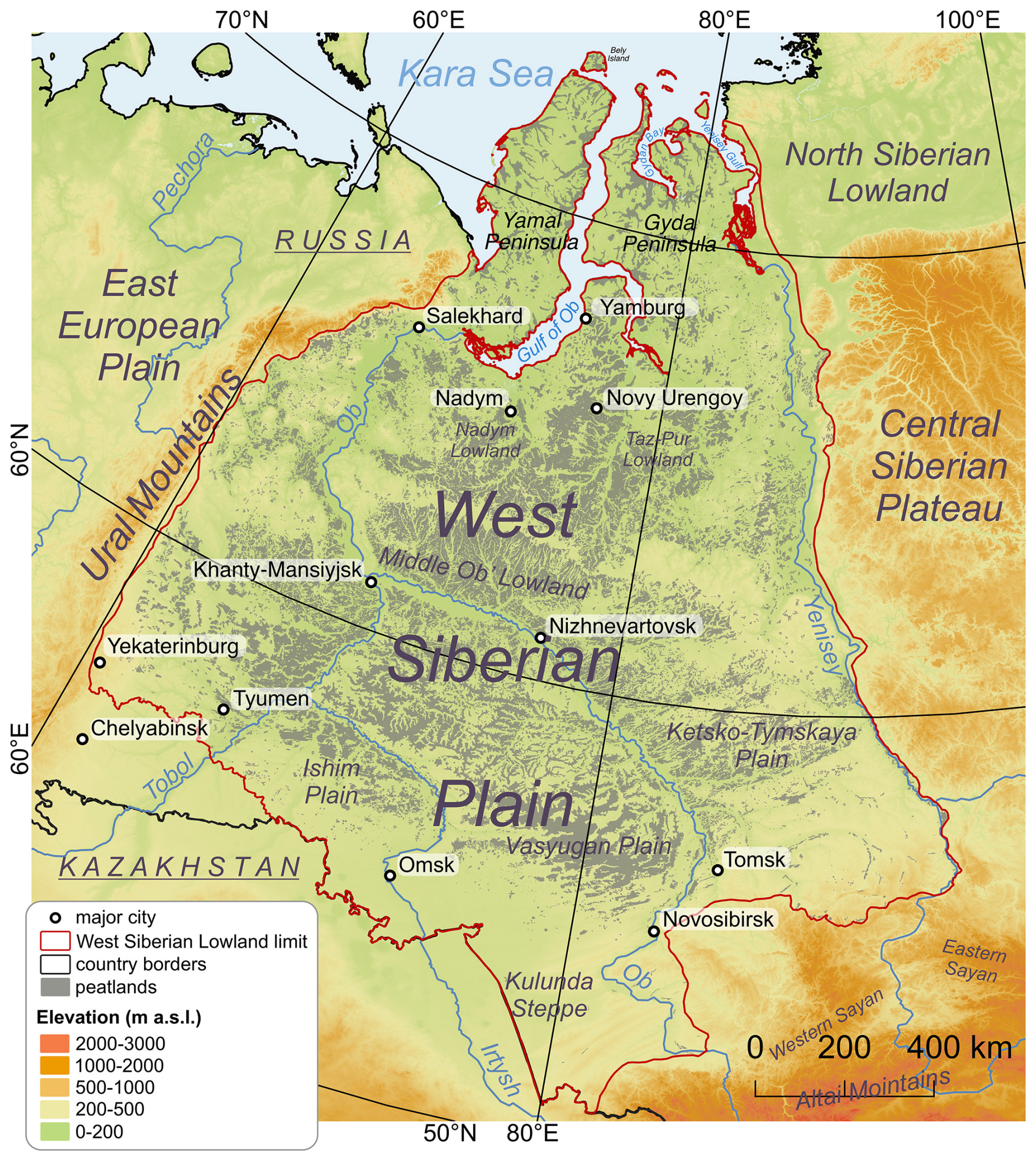
Figure 1Topographic map of Western Siberian Lowland with the extent of peatlands based on Sheng et al. (2004), main rivers, selected cities, main geographic units and geographical extent of study area considered in this literature review. Elevation source: © DLR e.V. 2010–2014 and © Airbus Defence and Space GmbH 2014–2018 provided under COPERNICUS by the European Union and ESA; all rights reserved.
2.1 Peatland extent mapping
Estimates of peatland extent in WSL have varied considerably over time due to differences in mapping methods, definitions, and data availability. Early studies reported smaller areas; for example, Neustadt (1971) as a first estimated peatland extent to 325 380 km2, later Tiuremnov (1976) 341 000 km2, and Efremov and Efremova (2001) 464 000 km2, illustrating the progressive refinement of peatland inventories. Sheng et al. (2004) provided a more detailed assessment, estimating 592 440 km2 of peatlands with a total carbon pool of 70.2 Pg C, based on a comprehensive GIS-based inventory combining decades of Geoltorfrazvedka field surveys, Russian wetland maps, satellite imagery, and extensive digitized peat depth and carbon data (Fig. 2a). However, the authors noted that this estimate should still be considered a minimum value because the Russian survey data used in the compilation did not include thin peat deposits (< 50 cm). Modern global products, such as the Global Peatland Map 2.0 (GPM2.0), classify regions as peat-dominated or peat-in-soil-mosaic at a 1×1 km resolution by integrating multiple regional and national datasets using proxy mapping, satellite classification, and expert judgement (Greifswald Mire Centre, 2022). The available version of GPM uses a peat depth threshold of ≥ 10 cm to account for climate-relevant peat carbon, rather than the conventional agricultural threshold of ≥ 30 cm, which increases Russia's estimated peatland area 2.6 times (UNEP, 2022). While GPM provides consistent and updated coverage, its ≥ 10 cm threshold overestimates the area of peatlands that are relevant for palaeoecological reconstruction. This overestimation is particularly visible in the continuous permafrost zone, where it shows nearly continuous peatland coverage; as well as along the western border and in the eastern parts of the region, including the Yenisey valley and the Ketsko-Tymskaya Plain (Fig. 2b). Therefore, for this review, the regional map created by Sheng et al. (2004) remains the most reliable source for WSL peatlands. Although this inventory likely underestimates the total peatland extent because peat deposits thinner than 50 cm were excluded, its methodological framework and closer correspondence to the ≥ 30 cm threshold commonly applied in palaeoecology make it more suitable for this review than GPM. Nevertheless, the selection of peatland datasets and peat depth thresholds should be considered in relation to the specific research objective. Inventories based on lower thresholds (e.g. ≥ 10 cm) may be more appropriate for large-scale carbon balance and climate-related studies, whereas thresholds closer to ≥ 30 cm are generally more applicable in palaeoecological investigations focused on sufficiently developed peat sequences suitable for long-term environmental reconstruction. Therefore, future field campaigns and research expeditions in WSL should evaluate peatland products and thresholds according to the aims of the study.
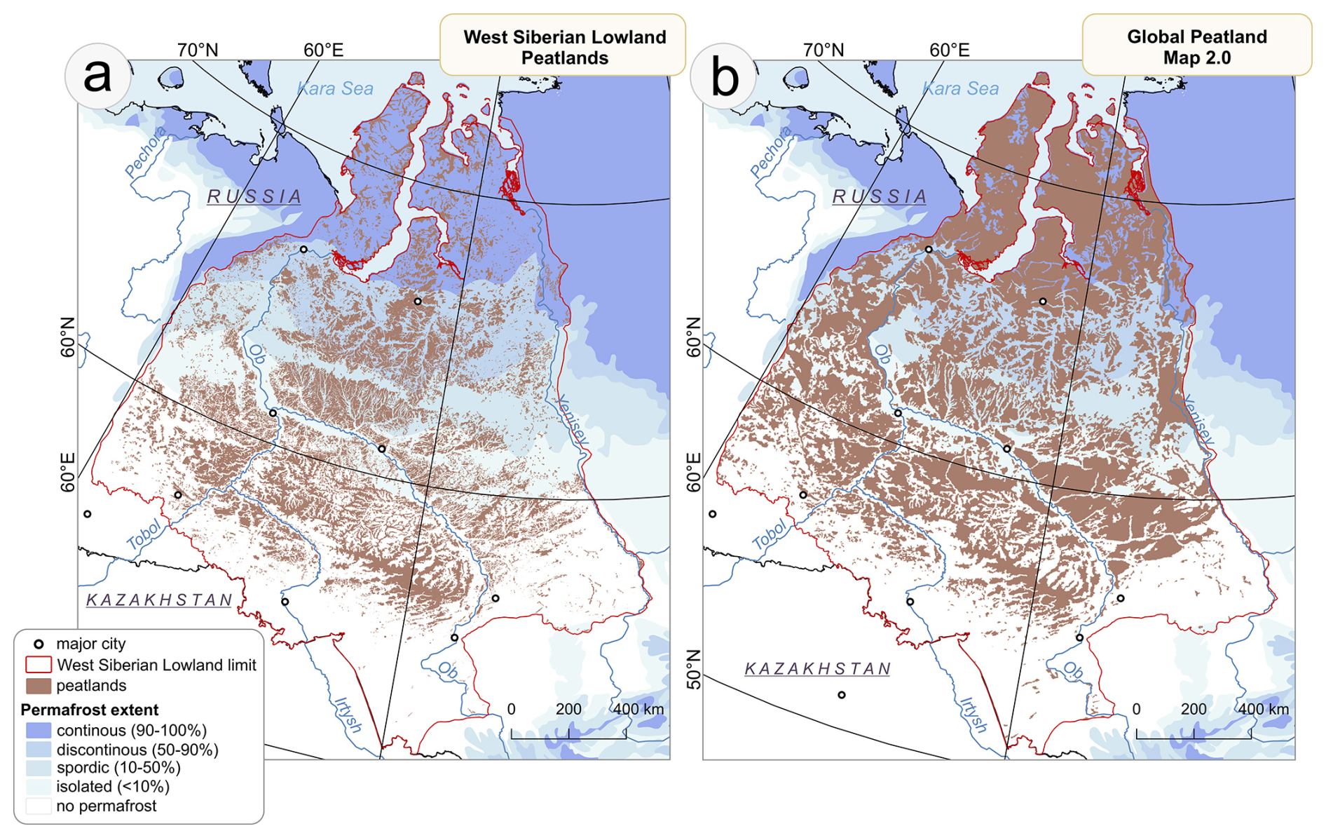
Figure 2Spatial distribution of peatlands in the Western Siberian Lowland: (a) regional map by Sheng et al. (2004) with peat depth threshold > 50 cm; (b) Global Peatland Map 2.0 (Greifswald Mire Centre, 2022) with peat depth threshold ≥ 10 cm.
3.1 Literature selection
The literature selection was based on two online databases of scientific papers: Google Scholar and Scopus, using the keywords “Western Siberia” AND “reconstruction” AND “peatland”. The initial results were screened manually to identify relevant studies. We applied specific inclusion and exclusion criteria to select studies further used in this review:
-
Publication type: only published articles and books were considered.
-
Time span: studies published up to May 2025 were included.
-
Language: only publications in English or Russian were considered.
-
Temporal coverage: only stratigraphic peat cores or peat cross-sections were included, with a focus on Holocene records.
-
Geographical extent: only studies in which at least one peat core was located within the borders of the Western Siberian Lowland (Fig. 1), as defined by Sheng et al. (2004) were included (Sheng, 2016).
-
Core location: studies were included if they reported precise or approximate coring coordinates, or if approximate locations could be estimated from maps provided in the original publication. Studies lacking sufficient locational information were excluded.
-
Coring material: only peat sediments (peat cores or peat cross-sections) were included. If the type of sediment could not be clearly determined, the core was excluded.
-
Study type: eligible studies presented original palaeoecological data derived from peat cores, or meta-analyses synthesizing data from a defined set of peat core studies. Review articles and books that only summarized previously published data without referencing specific peat cores were excluded. We also excluded studies based solely on modelling or simulations not directly grounded in empirical peat core data.
-
Minimum information required: to be eligible, peat cores had to provide at least one source of palaeoecological information (proxy), regardless of whether chronology was available (e.g., palynology, charcoal analysis, loss-on-ignition or bulk density). In addition, cores were also considered if they contained only chronological information or only basal depth data.
3.2 Data extraction and database creation
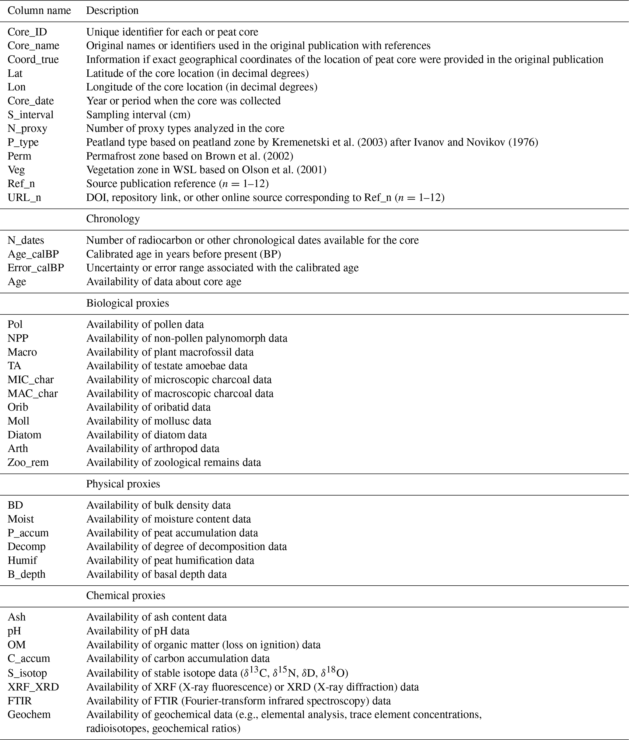
After compiling a database of relevant studies, we developed the Western Siberian Peat Core Database (WSPC) by extracting information on individual cores from each publication. For every peat core, we recorded the following required information: location, core name and applied proxies. Whenever available, we also collected supplementary details, including coring date, dating method, number of dated levels, temporal span of the record and sampling resolution. In total, 26 different proxies were identified (Table A1). To avoid duplication, we cross-checked all entries to identify peat cores reported in multiple publications. We first compared core names and reported coordinates (or approximate locations when exact coordinates were unavailable). When cores shared identical or nearly identical locations and had the same ages, lab numbers, basal depths, reference or any unique metadata that could be compared, we treated them as the same record. In cases where the same core was described across multiple publications, we merged the information into a single record. The ages of the records were obtained from the original publications, expressed in calibrated radiocarbon years (cal. yr BP) where available. For 27 sites with only uncalibrated ages, calibration was conducted in R Statistical Software (R Core Team, 2022) using the bchron package (Haslett and Parnell, 2008) and the IntCal20 calibration curve (Reimer et al., 2020) (Table A2). Peat cores were identified as basal (representing the complete peat sequence down to the mineral substrate) when such information was provided in the source publication, or when it could be inferred from the stratigraphic diagrams. In the WSPC database, each peat core was assigned a unique Core ID in the format WS_X (e.g., WS_001, WS_002, WS_003). Cores were numbered sequentially according to their geographic position, starting from the southernmost site and progressing northwards. In addition to the assigned Core IDs, we retained the original core names as reported in the source publications and databases to facilitate easier identification and cross-referencing. Each core includes also references to the original source from which the authors of this database obtained it, as well as information about the publication of the initial core source, if such details were provided in the reviewed publication.
3.3 Spatial analysis and data visualization
3.3.1 GIS data preparation and spatial datasets
To visualize and analyse the spatial distribution of peat cores, a shapefile (SHP) layer was created for WSPC database. All sites were georeferenced and compiled into a unified GIS layer using QGIS 3.16.2 software (QGIS Development Team, 2025), with the database attribute structure described in Table 1. The extent of the study region, as well as all subsequent spatial analyses, followed the WSL boundary as described by Sheng et al. (2004). Given the vast extent of the study region and clustering of coring sites, peat core density was assessed by dividing the area into 50×50 km grid cells. The number of cores within each cell was calculated using the join attributes by location (summary) tool (geometric predicate: contains) in QGIS. Besides the attributes obtained from the original publications, each peat core record was supplemented with information on its location within specific vegetation, permafrost, and peatland zones using the same tool in QGIS. Spatial data about vegetation zones were obtained from the map of terrestrial ecoregions by Olson et al. (2001), while permafrost extent was derived from the circum-Arctic map of permafrost and ground-ice conditions by Brown et al. (2002). The spatial extent of peatland zones was based on the map of major peatland zones originally published by Ivanov and Novikov (1976) and reproduced in Kremenetski et al. (2003). This map was georeferenced and digitized for use in this study.
Table 1The column headers within Western Siberian Peat Core database and their meaning.
3.3.2 Temporal coverage analysis and permafrost-related grouping
To analyse the percentage of peat cores covering each time interval, we assumed that the age of the record represents the period from the time of sampling back to the oldest dated level, although in some cases (particularly in the northern part of the study area) this may not have been the case. The same assumption was used to analyse the temporal coverage of individual proxies across WSL. Given the substantial influence of permafrost on sampling and data availability, peat cores were classified into three groups corresponding to different permafrost zones: (1) non-permafrost and isolated permafrost, (2) sporadic and discontinuous permafrost, and (3) continuous permafrost.
3.3.3 Scoring system and spatial visualization of proxy representation
To evaluate peat core datasets, we developed a quantitative scoring system to assess the quality and informational value of each peat core record. Proxies were grouped into three categories (biological, physical, and chemical) and each proxy was assigned an individual weight reflecting its relative contribution to environmental reconstructions (Table A3). In addition to proxy-specific weights, we also applied an additional weighting step when integrating proxy information into the final scores. For each proxy group (biological, physical, and chemical), the total sum of all proxy weights from a given group was multiplied by a factor of 4 to emphasize the contribution of group-level proxy richness. When calculating the overall proxy score, the total sum of all proxies across groups was instead multiplied by 5, giving greater influence to records that include a broad suite of proxy types. Each record was also evaluated based on (1) the presence of a chronology, (2) total record length, and (3) the number of proxy types available. These components were scaled to 0–1 and combined with the weighted proxy information to generate four aggregated scores (combined_bio, combined_phys, combined_chem, and combined_all) (Table A4). Higher scores indicate records with greater chronological control, longer temporal coverage, and richer multiproxy data. All calculations were performed in R Statistical Software (R Core Team, 2022) using the dplyr package (Wickham et al., 2023) for data manipulation. Spatial patterns of combined scores were visualized using QGIS. We applied the Heatmap (Kernel Density Estimation, KDE) tool to each dataset, using a 30 km radius and a pixel size of 100×100 m. The KDE was weighted by the combined scores of all proxies as well as separately for the biological, chemical, and physical proxy groups. The resulting density maps provide a spatially smoothed representation of proxy distribution and highlight both well-sampled regions and areas with insufficient proxy coverage.
3.3.4 Literature-based data extraction and figure assembly
For the literature analysis, if the full text of publication was unavailable, information on the language and proxies used was inferred from the available title, abstract, or bibliographic data accessible to the authors. All plots and diagrams were prepared in R Statistical Software (R Core Team, 2022) using ggplot2 (Wickham, 2016) package, and final figures were assembled in CorelDRAW Graphic Suite 2021.
4.1 Peat core studies in the Western Siberian Lowland – literature analysis
4.1.1 Source publications overview
The database was compiled from a total of 156 publications published between 1953 and 2025, which were classified into two categories. The first group primary sources included 99 publications identified through an extensive literature review, from which data were directly obtained and used to build the database. The second group secondary sources included 57 original publications that were not directly accessible, but were cited within the primary publications used for data extraction. For each core, references are provided both to the publication from which the data were obtained (primary source) and, where available, to the original source publication cited therein (secondary source). The WSPC database is based on 82 English-language, 73 Russian-language, and one German-language publications. The authors had direct access to 79 of the English-language and 20 of the Russian-language sources.
The publications used in the compilation of the database contained information on varying numbers of peat cores. The majority of studies (82 %) presented data from one to five cores, typically providing reconstructions at the local or regional scale. Another 13 % of the publications included results from six to fifty cores. These studies analysed various regions within the Western Siberian Lowland (WSL), often along transects across peatlands, or incorporated WSL data as part of larger datasets. Only eight publications contained datasets with more than fifty peat cores. These studies generally focused on large-scale syntheses addressing specific research questions at the global scale (such as carbon accumulation) or provided a more detailed analysis of the WSL, and include Kremenetski et al. (2003), Sheng et al. (2004), Smith et al. (2004, 2012), MacDonald et al. (2006), Loisel et al. (2014), Hugelius et al. (2020), and Lapshina and Zarov (2023).
Based on conducted literature review, it was observed that between 1950 and 1990, the number of peat core studies in WSL increased notably, with most results published in Russian-language journals or books and only a limited number appearing in English (Fig. 3a). This pattern reflects the early growth of peat research during the Soviet period and the dominance of domestic Soviet research activity, as the region remained largely inaccessible to the international scientific community. After 1990, this trend shifted, as the number of English-language publications increased rapidly, reflecting the onset of international collaboration after the collapse of the USSR. The decade 2010–2020 saw the highest number of publications, reflecting not only regional research dynamics but also the broader global growth in scientific output. Although the decade 2020–2030 is only halfway through, 28 papers on this topic have already been published. While this trend may suggest that the current decade will produce the highest number of publications, ongoing geopolitical tensions, limited accessibility of some areas, and difficulties in collaborating with Russian scientists may slow down further research activity.
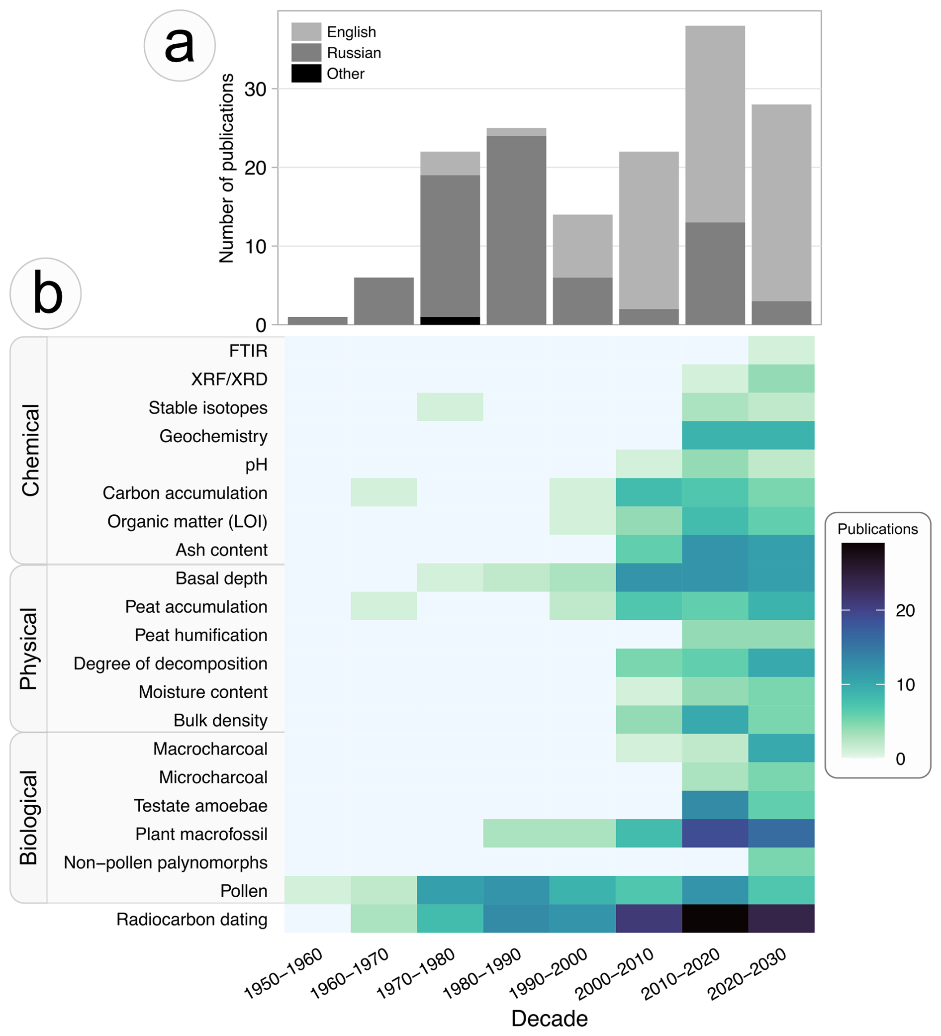
Figure 3Temporal patterns in research output and methodological approaches: (a) trends in the number of publications in Russian and English per decade; (b) frequency of selected proxies used in studies across decades. Abbreviations: XRF – X-ray fluorescence; XRD – X-ray diffraction; FTIR – Fourier-transform infrared spectroscopy.
4.1.2 Trends in palaeoecological proxy use in the Western Siberian Lowland
Based on the use of proxies, two distinct periods can be identified in WSL studies: an early stage (1950–2000), characterized by single-proxy studies, and the modern period (after 2000), marked by increasing integration of biological, physical, and chemical indicators (Fig. 3b). A major step forward in peatland research was the implementation of radiocarbon dating, developed in the 1940s (Olsson, 2009). Since the 1960s, it has become increasingly important in paleoenvironmental studies and remains the most widely applied chronological tool in peatland research in WSL (Kremenetski et al., 2003). Whereas earlier studies often reported results solely based on depth, radiocarbon dating is now used almost universally. Basal depth was an important physical parameter not only from a scientific perspective but also from an economic one. The discovery of oil in the 1950s initiated intensive studies of WSL peatlands, as information on peat thickness was essential for constructing roads and infrastructure required for oil exploration (Kremenetski et al., 2003). Early decades were dominated by classic palynological studies. Pollen was the first biological proxy applied in this region and has maintained its importance to the present day. However, although pollen analysis is widely used, it primarily provides information about the vegetation and environment surrounding the peatland rather than the peatland itself. Growing interest in peatland development led to the increasing use of plant macrofossil analysis, which began to be applied from the 1980s onward. After 2000, more proxies started to be implemented in research on WSL. New biological proxies, such as testate amoebae and micro- and macrocharcoal, were introduced, providing valuable tools for reconstructing changes in peatland hydrology and fire activity at different spatial scales. More laboratory analyses aimed at obtaining more precise data on the physical and chemical properties of peat began to be applied (e.g., bulk density, pH, ash content), along with newly developed technologies introduced over the past decade (e.g., XRF (X-ray fluorescence), FTIR (Fourier-transform infrared spectroscopy)). Peat and carbon accumulation were already studied in research conducted before 2000; however, their frequency had increased noticeably since then. The increased variety of applied proxies over the past 25 years, on one hand reflects the development of new research methods, and on the other, a growing awareness of the importance of peatland ecosystems and the desire to better understand their history.
4.2 Western Siberian Peat Core Database
4.2.1 General information and spatial distribution
The Western Siberian Peat Core Database (WSPC) includes information on the locations and applied palaeoecological proxies of 654 peat cores or peat cross-sections collected from the WSL (Fig. 4a). The spatial distribution of cores highlights the considerable challenges associated with conducting research in the WSL peatlands. Their vast extent, the widespread presence of permafrost, and limited transport accessibility largely determine the areas where sediment sampling is logistically feasible. Notably, 47 % of all peat cores (306 out of 654) included in the WSPC database were collected within a 100 km buffer zone of the major rivers: Ob, Yenisey, Irtysh, and Tobol, with high density of cores in the Middle Ob' Lowland (Fig. 4b). A distinct concentration of collected cores is observed in the Great Vasyugan Mire (west of Tomsk), which represents the largest contiguous peatland in the world (Fig. 4c) (Kirpotin et al., 2009). Various parts of this extensive complex have been the focus of numerous previous studies (e.g. Blyakharchuk et al., 2019; Lapshina and Zarov, 2023; Rudmin et al., 2018; Syso and Peregon, 2009) due to the absence of permafrost and the proximity to major cities facilitating field work organisation. Another distinct concentration of peat cores is observed in the central part of the study region, between the Ob and Yenisey rivers, where numerous cores were collected during extensive Russian-American field campaigns conducted between 1999 and 2001 (Sheng et al., 2004; Smith et al., 2000). Although the railway network in WSL is relatively sparse, a major line crosses this area, connecting Tyumen with Novy Urengoy, Nadym, and Yamburg, thereby facilitating logistical access to this part of the region. Peatlands in the northern part of the WSL have been studied mostly on the Yamal Peninsula, with a few coring sites on the Gyda Peninsula, mainly along the shore of the Gydan Bay. The northernmost core in the database was located on Bely Island (73.34190° N, 70.12760° E) and southernmost on Dolgon'koye swamp (53.21250° N, 84.40720° E).
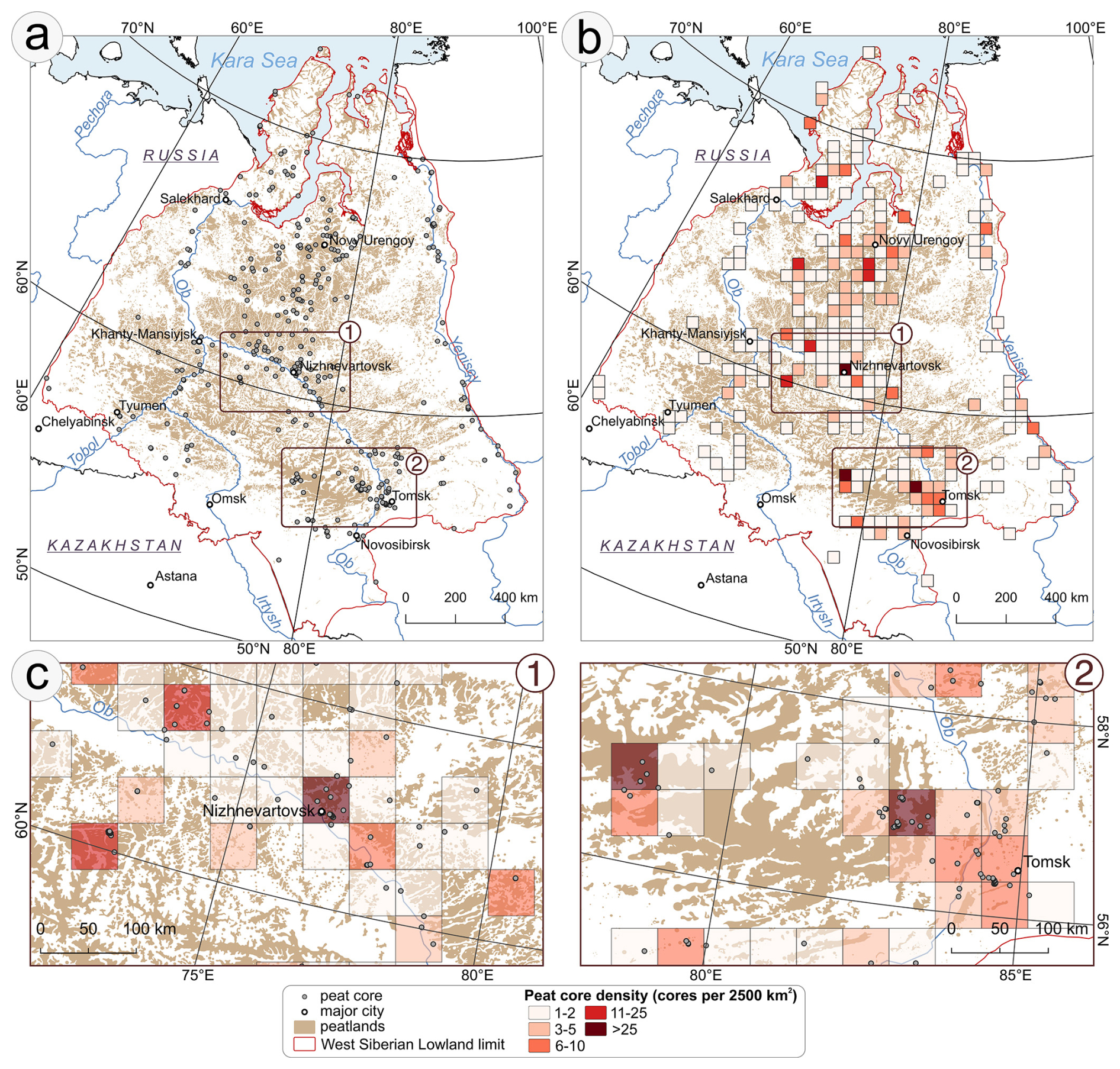
Figure 4Distribution of peat cores in Western Siberian Peat Core Database: (a) spatial distribution of peat cores in Western Siberia Lowland (WSL), (b) peat core density (number of cores per 2500 km2), (c) the zoomed maps of two regions within the WSL: (1) peatland complexes in the Middle Ob' Lowland near Nizhnevartovsk, and (2) the eastern part of the Great Vasyugan Mire. Maps include peatlands extent based on Sheng et al. (2004).
The WSPC database includes peat cores, representing a broad range of environmental settings across the region. Peatlands in WSL occupy all major permafrost zones and vegetation types, although their spatial extent and sampling intensity vary (Fig. 5a, c). Peatlands are most extensive in the non-permafrost zone, which covers 41.5 % of the total peatland area, followed by the discontinuous (18.6 %), sporadic (14.1 %), isolated (13.9 %), and continuous (11.9 %) permafrost zones. In general, the number of peat cores reflects the relative area of peatlands in each zone. The two permafrost zones with the largest peatland areas also have the highest numbers of peat cores: the non-permafrost zone (278 cores, 42.5 % of the total) and the discontinuous permafrost zone (132 cores, 20.2 %). The number of peat cores in the isolated (94 cores, 14.4 %) and continuous (101 cores, 15.4 %) permafrost zones also corresponds closely to the proportion of peatland area in these zones. The main exception is the sporadic permafrost zone, which contains the third-largest share of peatland area (14.1 %) but is relatively underrepresented, accounting for only 7.5 % of all peat cores in the database.
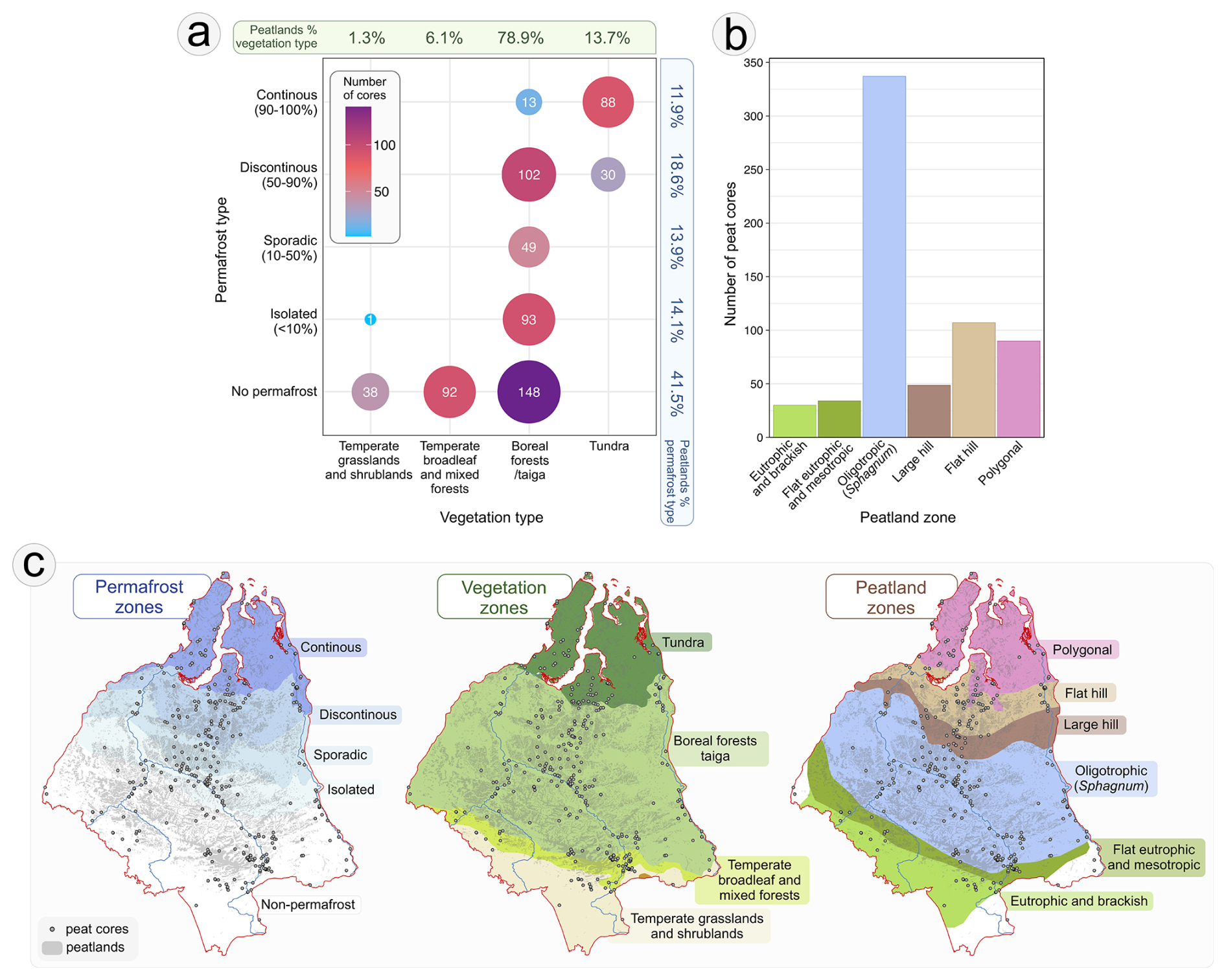
Figure 5Distribution of peat cores in the Western Siberian Peat Cores Database by permafrost, vegetation, and peatland type; (a) number of peat cores within each permafrost zone and vegetation type, with percentages of peatlands occurring in each category; (b) number of peat cores by major peatland zones; (c) spatial distribution of peat cores in relation to permafrost zone, vegetation type and peatland type. Vegetation zones are based on Olson et al. (2001), permafrost extent on Brown et al. (2002), major peatland zones on Kremenetski et al. (2003) (after Ivanov and Novikov, 1976), and peatland extent on Sheng et al. (2004).
Across vegetation types, the majority of WSL peatlands are associated with boreal forests/taiga (78.9 %), followed by tundra (13.7 %), temperate broadleaf and mixed forests (6.1 %), and temperate grasslands and shrublands (1.3 %). The distribution of peat cores reflects this pattern: cores from peatlands in boreal forests dominate the dataset (405 cores, 61.9 %), followed by tundra sites (118 cores, 18.0 %), while mixed forests (92 cores, 14.1 %) and shrubland peatlands (39 cores, 6.0 %) are considerably less represented by peat cores in the database.
Based on major peatland zones, polygonal peatlands, which dominate north of 67° N and are associated with continuous permafrost and tundra vegetation, are represented by 90 cores (13.8 %) in the database (Fig. 5b, c). Flat hill and large hill peatlands, which occur predominantly within the discontinuous permafrost zone and are associated with taiga vegetation between 61–67° N, account for 107 (16.4 %) and 49 (7.5 %) cores, respectively. Oligotrophic (Sphagnum-dominated) peatlands, concentrated between 56–61° N and typically associated with boreal forest/taiga areas exhibiting either non-permafrost, isolated or sporadic permafrost, represent the most frequent peatland type in WSL and are represented by the largest group of 337 cores (51.5 %). The two southernmost peatland zones, where permafrost is absent and temperate vegetation types predominate, are the least represented in the dataset. Flat eutrophic and mesotrophic peatlands, occurring in a narrow belt from 55–58° N in the east and up to 60° N in the west, include 34 cores (5.2 %), while eutrophic and brackish peatlands, located south of 55° N, form the smallest group, with 30 cores (4.6 %). Additionally, 7 cores (1.0 %) are outside the extent of the defined peatland zones.
4.2.2 Variation in the number of proxies per core
The WSPC database documents the application of 26 palaeoecological proxies in peat cores in the WSL, grouped into four categories: biological, physical, chemical and chronological (Fig. 6b, Table A1). Peat cores in the database differ substantially in the number of applied proxies, ranging from only one to a maximum of 12 per core (Figs. 6a, 8a). The most common in the database were cores containing one or two palaeoecological proxies, representing 26.3 % and 28.4 % of all records, respectively. Peat cores that include only a single proxy most commonly contain information on basal depth or sediment age; and in some cases, pollen or plant macrofossil data. For cores containing only biological proxies, this may be explained by the extraction of data from more recent, method-focused publications (e.g. palynology), whereas broader and potentially more comprehensive information may have been reported in earlier sources that were inaccessible for the authors of this database. In cores containing two proxies, the most frequent combinations include basal depth or age paired with either pollen or carbon accumulation data. Peat cores containing data from three to six proxies typically include several biological proxies combined with age or basal depth information, and in some cases supplemented with peat property measurements (e.g. peat or carbon accumulation, or organic matter content). The second most common proxy count is seven (13.0 %). Within this group, two distinct core types can be distinguished: (1) cores that resemble the “3–6 proxy” category but incorporate more biological proxies, and (2) cores that lack biological proxies but provide more extensive data on the physical and chemical properties of peat. Cores containing eight or more proxies represent multi-proxy analyses, integrating biological, physical, and chemical data along with sediment dating, and thus provide the most comprehensive information on the history of the studied peatlands. Only 9.8 % of all cores include this number of proxies, while just 1.2 % contain ten or more. The spatial distribution of peat cores with a given number of proxies is also evident (Fig. 8a). High concentrations of well-studied peatlands occur along major rivers, particularly the Ob (Mukhrino, Sredne Vasyuganskoe, Samara, and Bakchar) and the Yenisey (Igarka). Given its large size and ecological significance, the Great Vasyugan Mire also contains numerous peat cores with a high number of proxies, reflecting its long-term use as a key site for multi-proxy palaeoecological research. Another cluster of cores analysed with multiple proxies is observed in the central part of the study region, between the Ob and Yenisey rivers. These cores were mostly collected during Russian-American field campaigns and include detailed physical and chemical analyses of peat, as well as cores described in single-core studies, such as the Khanymei peatland (Halaś et al., 2025).
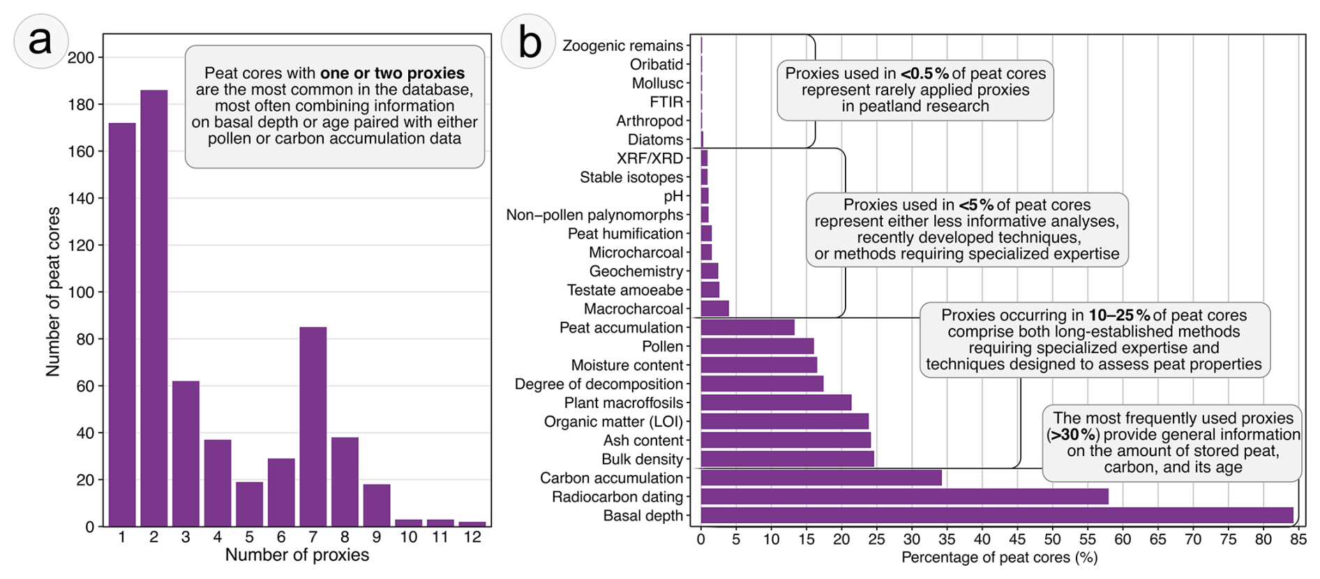
Figure 6Summary of palaeoecological proxies applied in peat cores in the Western Siberian Peat Core Database; (a) number of proxies used and corresponding number of peat cores, (b) frequency (%) of use of individual proxies across the peat cores. Abbreviations: XRF – X-ray fluorescence; XRD – X-ray diffraction; FTIR – Fourier-transform infrared spectroscopy.
4.2.3 Relative use of different proxy and their regional patterns
In the WSPC database, a total of 26 palaeoecological proxies has been applied to peat cores from WSL; however, their use varies significantly, both in quantitative frequency and in spatial distribution across the study area (Figs. 6b, 7, B1).
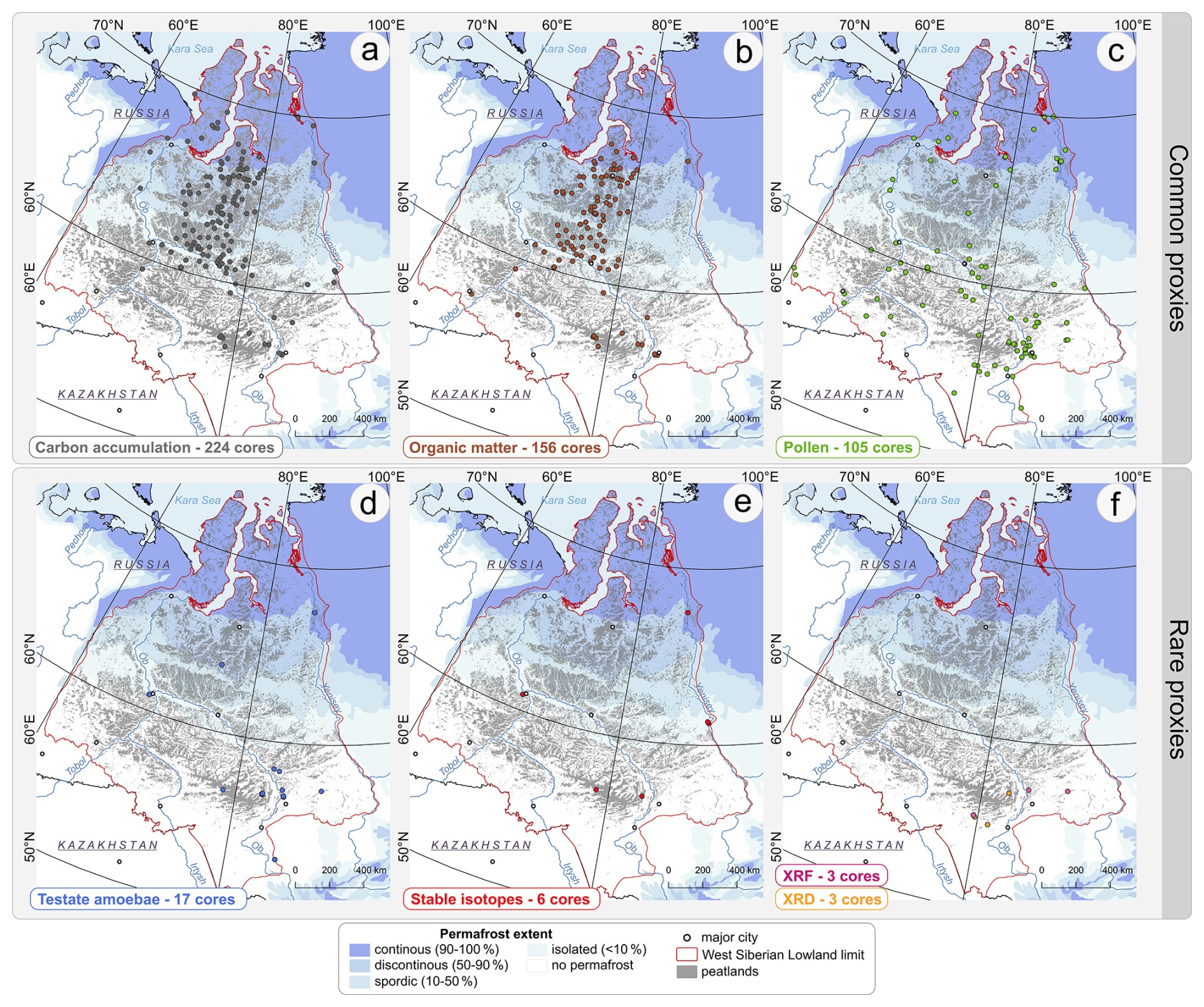
Figure 7Spatial distribution of peat cores included in the Western Siberian Peat Core Database with records of selected proxies. Commonly used palaeoecological proxies are shown in panels (a)–(c) ((a) – carbon accumulation; (b) – organic matter; (c) – pollen), while rarely applied proxies are presented in panels (d)–(f) ((d) – testate amoebae; (e) – stable isotopes; (f) – XRF/XRD). Numbers indicate the total count of cores containing each proxy. Maps include peatlands extent based on Sheng et al. (2004) and permafrost extent based on Brown et al. (2002). Abbreviations: XRF – X-ray fluorescence; XRD – X-ray diffraction.
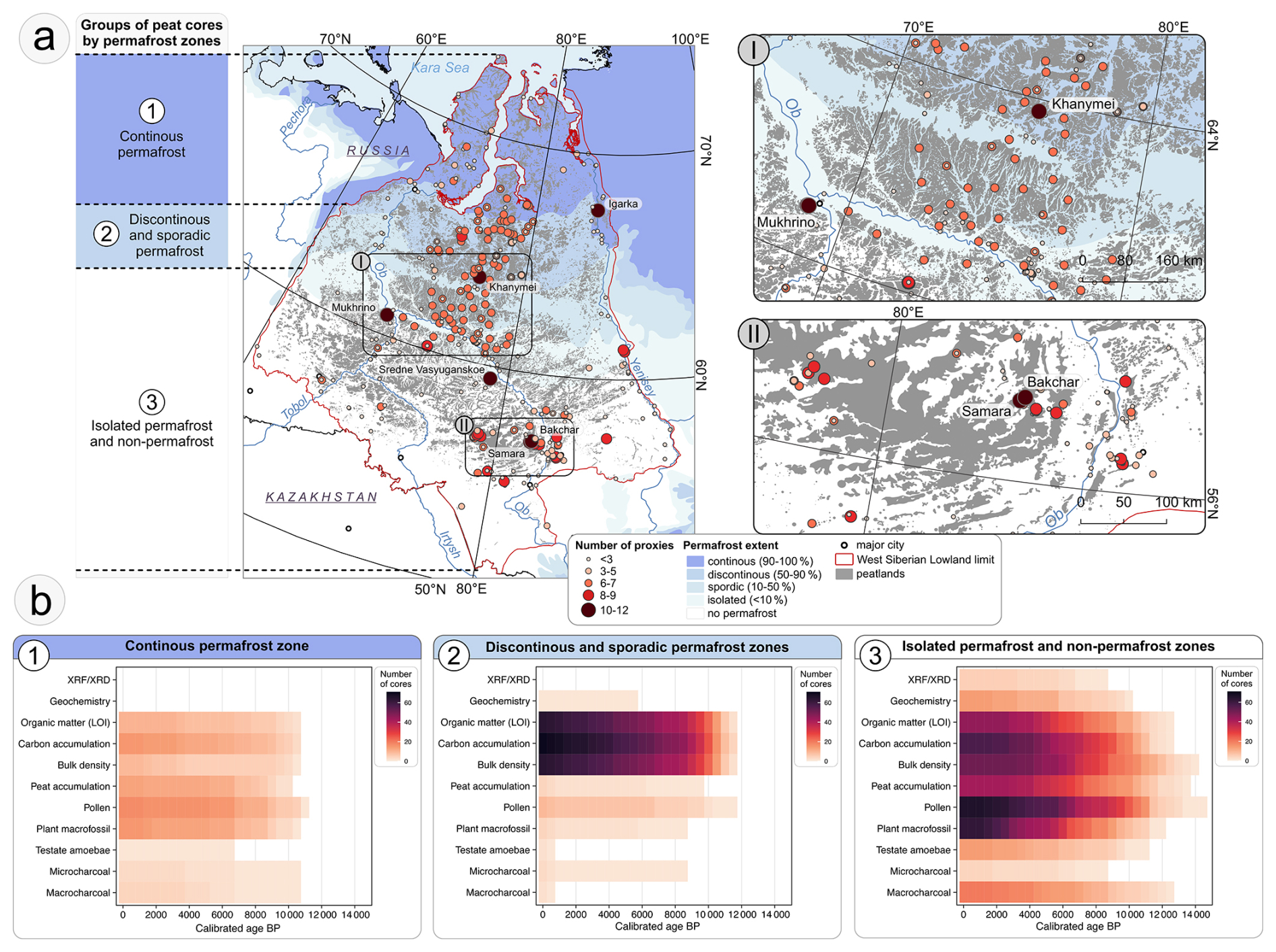
Figure 8Palaeoecological proxies used in peat cores in the Western Siberian Peat Core Database: (a) spatial distribution of peat cores categorized by the number of proxies analysed, with names of peatlands (cores) with the greatest number of proxies, permafrost zones based on Brown et al. (2002), and peatland extent based on Sheng et al. (2004); (b) heatmaps of the temporal coverage of individual proxies within three groups of cores distinguished by permafrost zone: (1) the continuous permafrost zone, (2) the discontinuous and sporadic permafrost zones, and (3) the isolated permafrost and non-permafrost zones. Colour intensity reflects the number of cores contributing data within 500-year intervals. Abbreviations: XRF – X-ray fluorescence; XRD – X-ray diffraction. Heatmaps were prepared only based on cores with established chronologies.
Chronological proxies
Chronological proxies are essential for reconstructing peatland development over time and were applied in 58.0 % of all peat cores. Radiocarbon dating is by far the most frequently used method in the region, enabling age-depth modelling and temporal correlation of palaeoecological data (Chambers and Charman, 2004). The resolution of dating varies considerably between cores: some cores were dated only at the basal level, whereas others include several dated horizons. This variability often reflects financial constraints, as multipoint dating remains relatively expensive. Nevertheless, in recent decades researchers have increasingly adopted multi-level dating within individual cores to achieve more robust reconstructions and to facilitate comparison with paleoclimate data (e.g. Feurdean et al., 2019; Lamentowicz et al., 2015; Leonova et al., 2022; Novenko et al., 2023). Due to its widespread application, the spatial distribution of this proxy is relatively uniform, and it is represented in peat cores across most of WSL (Fig. B1a).
Physical proxies
Physical proxies, which provide information on peat properties and stratigraphy, are frequently applied in the peat cores included in the database in the database. Basal depth is by far the most common proxy, present in 84.3 % of cores (Fig. 6b). Such a large number of basal depth measurements is primarily due to the fact that this parameter is relatively easy to obtain in the field and usually does not require specialist expertise (Parry et al., 2014). Many basal depth data were collected during geological prospecting campaigns or as part of detailed investigations of the development of individual peatland complexes (Kremenetski et al., 2003; Lapshina and Zarov, 2023). This widespread use reflects both its fundamental importance for peatland development studies and its relevance as an economically significant parameter (Fig. B1b). Another important physical proxy useful e.g. for carbon content calculations is bulk density, reported in 24.6 % of cores, mostly from the central part between the Ob and Yenisey rivers and from the Vasyugan Plain (Fig. B1c). Degree of decomposition and peat humification are both analyses that indicate the intensity of decay processes; however, the methods differ (Biester et al., 2014). Peat humification is an older technique and is rarely used (1.5 % of cores), whereas the degree of decomposition, usually assessed via the von Post scale – a traditional Russian field method – is much more common in WSL cores (17.4 %). Their occurrence within the study area is characterized by a clear concentration in the south, on the Vasyugan Plain, while in the remaining regions the proxy is represented only in a small number of sites (Fig. B1d, g). Moisture or water content, a proxy useful for interpreting decomposition processes or nutrient mobility (Rydin et al., 2006), was applied in 16.5 % of all cores, and its spatial distribution is similar to that of bulk density (Fig. B1e). Peat accumulation is an important proxy that not only provides information about peatland development but can also indirectly inform about past climate variability (Swindles et al., 2025). It was used in 13.3 % of the cores, which are distributed across the study region, with more sites located on the Vasyugan Plain (Fig. B1f). The form in which this information is reported varies depending on analytical resolution, sometimes it is a single value for the entire core, and its accuracy increases with increasing resolution. Nevertheless, accumulation rates in permafrost-affected peatlands should be interpreted with caution, as cryogenic structures and variable ice content may substantially influence peat accumulation and preservation processes (Treat et al., 2016). However, such information was not consistently reported in the analysed studies and therefore could not be systematically included in the database.
Chemical proxies
Chemical properties of accumulated peat in WSL have also been frequently analysed in peat cores. The most commonly used chemical proxy is carbon accumulation, applied in 34.3 % of all studied cores (Fig. 6b). This proxy provides valuable information about the total amount of stored carbon in the peat and about long-term changes in peatland carbon sink strength (Charman et al., 2015). WSL is recognized as a global carbon hotspot; therefore, many studies focus on carbon budgets and accumulation patterns, which explains the widespread use of this proxy. This proxy is predominantly reported in sites from the central part of the study region and the peatlands of the Vasyugan Plain; however, cores containing this information are also frequently found in river valleys and on the Yamal Peninsula (Fig. 7a). Ash content and organic matter, typically measured via loss-on-ignition (LOI) analysis, are also commonly analysed in WSL peat cores, appearing in 24.2 % and 23.9 % of peat cores, respectively. These simple and low-cost methods are widely used in paleoecology and provide information about peat composition and the input of inorganic material (Chambers and Charman, 2004; Tolonen, 1984). Their spatial distribution is very similar and resembles the distribution pattern of bulk density (Figs. 7b, B1t). Other chemical proxies included in this database: geochemistry, pH, stable isotopes, XRF or XRD and FTIR have been rarely applied in WSL peat cores. Data on pH, which reflects peat acidity, are more characteristic of modern ecological surveys than of palaeoecological studies. Consequently, this proxy was used in only 1.1 % of all cores, exclusively in non-permafrost peatlands in the southern part of the region (Fig. B1w). Traditional geochemical analyses (2.4 %), stable isotopes (0.9 %), XRF/XRD (0.9 %), and FTIR (0.2 %) all require specialised expertise and laboratory infrastructure, which until recently were not widely accessible. Geochemical analyses and XRF/XRD are different methods for determining the elemental composition of peat. Geochemistry has become increasingly popular in recent years, whereas XRF and XRD, traditionally used in lake sediment studies, have only recently begun to be applied to peat (Longman et al., 2019; Shotyk, 1988). Geochemical analyses have been conducted in several peatlands south of 64° N, while XRF/XRD has been used primarily in peatlands near Tomsk in the south-eastern part of the study area (Figs. 7f, B1v). Stable isotopes in peat provide valuable insights into past environmental and climatic conditions; however, they are costly and require specialized isotope facilities (McClymont et al., 2010). Such data are scattered across WSL and are typically collected from cores analysed in extensive studies that integrate multiple other proxies (Fig. 7e) (Feurdean et al., 2019; Startsev et al., 2022).
Biological proxies
The group of palaeoecological proxies that has been the least frequently applied in WSL peat cores are biological proxies (Fig. 6b). They rely on the identification of remains of organisms preserved in peat and are therefore highly dependent on preservation conditions. Additionally, they are usually time-consuming and require specialist expertise. The most frequently used biological proxy, applied in 21.4 % of all cores, is plant macrofossils (referred to as “botanical composition” in older publications), which reflect local peatland vegetation and are essential for reconstructing peatland development and hydrology (Birks and Birks, 2000). However, the level of analytical detail varies between studies. In some cores, particularly in older works, the data are limited to reporting dominant Sphagnum species or other major plant groups, often at a low sampling resolution of 10 or 25 cm. In contrast, more recent studies tend to use higher-resolution sampling and more detailed identifications, frequently including subfossil vegetative fragments and carpological remains (e.g. Halaś et al., 2025; Novenko et al., 2022). Peat cores with plant macrofossil data are spread across WSL, with a higher concentration on Vasyugan Plain and in the area near Tomsk (Fig. B1h). Pollen is an excellent proxy for reconstructing past regional vegetation and landscape-scale ecological changes (Mander and Punyasena, 2018). Owing to its long-established use in palaeoecological studies, it was introduced very early in WSL research. To date, 16.1 % of all cores in the database contain pollen data. These cores cover the majority of WSL, with their highest frequency occurring in areas where core density is greatest (Fig. 7c). Non-pollen palynomorphs (NPPs) are additional microfossils that can be identified during standard palynological analysis (Shumilovskikh et al., 2021). Because Quaternary palynologists historically did not focus on these other palynomorphs, their identification is challenging, and their systematic documentation only began in the late 1970s, their use in WSL cores has remained limited. Although the scientific community has increasingly recognized the potential of this proxy to reflect local ecological conditions and it is now being applied at more sites (e.g. Feurdean et al., 2022; Halaś et al., 2025), only 1.1 % of all cores currently include NPP data, and these come from only a few locations in the WSL (Fig. B1m). Peatlands are also valuable archives of past fire activity, with charcoal commonly used as a proxy for this purpose. Depending on the intended spatial scale of fire reconstruction, different charcoal size fractions are analysed: macrocharcoal for local fires and microcharcoal for regional fire activity (Conedera et al., 2009). Both types are present in the WSL, although at low frequency. Macrocharcoal has been used more often, occurring in 4.0 % of all cores, whereas microcharcoal appears in only 1.5 %. There is no clear spatial pattern in their use; instead, they are found sporadically in isolated cores across the study area (Fig. B1j, l). A lack of fire-history research in WSL (and in Russia more broadly) was also noted by Pupysheva and Blyakharchuk (2023). They emphasized that fire proxies are relatively new to this region and highlighted the importance of expanding fire-history studies across this territory. Hydrology is one of the most important environmental variables controlling the condition of peatland (Rydin et al., 2013), and testate amoebae are a well-established proxy for reconstructing past hydrology of these ecosystems (Charman, 2001). Although their widespread use in palaeoecological research began roughly 40 years ago (Mitchell, 2025), their application in WSL peat cores remains very limited, appearing in only about 2.6 % of all studied cores. Testate amoebae have been used primarily in non-permafrost peatlands in the southern part of the WSL, while in other permafrost zones they have been applied only sporadically (Fig. 7d). Less frequently used biological proxies include arthropods, molluscs, oribatid mites, diatoms, and zoogenic remains, each recorded in less than 0.3 % of cores. Although these proxies can offer valuable insights into local environmental conditions, their preservation in peat is generally poor, and they are more characteristic of lake sediment studies. As a result, they are rarely applied in peatland research. This pattern is also evident in WSL, where their use in peat cores is limited to only a few isolated cases (Fig. B1n–r).
Overall, the WSPC database demonstrates a strong focus on fundamental physical and chemical proxies, particularly basal depth, carbon accumulation, and organic matter content, reflecting the importance of these variables in peatland palaeoecology. Biological proxies are applied more selectively, often depending on the research question, while more specialized proxies such as geochemistry, stable isotopes, or FTIR are rarely used. This distribution highlights both the breadth of multi-proxy approaches in WSL peatlands and the gaps in underrepresented proxy types, particularly in biological and specialized chemical analyses.
4.2.4 Age structure of peat cores and temporal coverage of proxies
The WSPC database includes three types of peat cores: (1) full-length sequences that extend from the basal mineral substrate to the sampling date and thus capture the complete peat accumulation history; (2) upper-only sequences that begin at the modern peat surface but do not reach the basal layer, typically resulting from targeted sampling strategies such as upper-core ecological reconstructions or from logistical constraints, particularly in permafrost regions; and (3) cores that may or may not reach the basal mineral substrate but are distinguished by the absence of the youngest peat layer due to climate-driven cessation of peat accumulation or degradation of previously accumulated peat, a pattern most commonly observed in polygonal peatlands in the northern part of the region. The temporal distribution of peat core ages, summarised in 300-year intervals, shows a highly uneven pattern, revealing several distinct phases across the time span up to ∼ 16 000 cal. yr BP (Fig. 9b). Since the majority of cores in the WSCP database were published after 1950 and type-3 cores are relatively rare, we assumed for this analysis that each peat core represents continuous data from 1950 to the deepest dated layer.
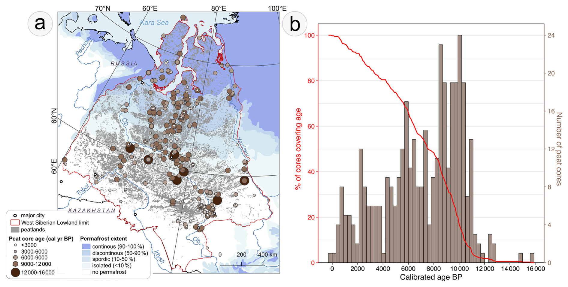
Figure 9Age distribution of peat cores in the Western Siberian Peat Core Database (WSPC): (a) spatial distribution of peat cores with calibrated ages (cal. yr BP) of basal or dated bottom levels across Western Siberian Lowland; (b) histogram of the number of peat cores within 300-year age intervals, representing the temporal coverage and length of palaeoecological records in the database, and percentage of peat cores in the WSPC database covering age. Map and plot created only based on cores with established chronologies.
Peat cores covering only the near-modern period (0–2000 cal. yr BP) are quite rare in the database, usually less than 5 cores per 300-year interval (Fig. 9b). There is an increase in the number of cores that cover longer periods of the Late Holocene up to 4000 cal. yr BP, with 6–12 cores per interval. Cores covering the Middle Holocene (∼ 4000–8000 cal. yr BP) form the second most frequent group, averaging 10 cores per interval. The highest representation is observed for cores spanning ∼ 8000–11 000 cal. yr BP, with nearly half of all chronologically established cores reaching this period. Beyond ∼ 11 500 cal. yr BP, the number of cores declines sharply, with only individual cores reaching into the Late Glacial. The oldest peat core in the WSPC database dates to 15 623 cal. yr BP (core WSL_246) and is located near the Yenisey River within a present-day non-permafrost region (Fig. 9a). Peat cores older than 11 500 cal. yr BP are exclusively situated south of 62° N, where current ground conditions correspond to non-permafrost or isolated permafrost zones, and all of these oldest records are located within 100 km of major river channels. The lack of records from this period is consistent with limited peatland development in WSL during the Late Glacial, when conditions were generally unfavourable for peat accumulation (Alexandrov et al., 2016; Velichko et al., 2011). In terms of coverage, ∼ 80 % of cores extend over the last 4000 cal. yr BP, ∼ 50 % reach 8000 cal. yr BP, and only ∼ 5 % cover 11 000 cal. yr BP.
Because the database includes both basal-depth and upper-only cores, these data cannot be interpreted as direct records of peatland initiation and serve as a basis for analysis spatial peatland development in WSL. Instead, it reflects the age extent of available peat profiles. Despite this limitation, the broad temporal pattern – many cores spanning the early Holocene and very few extending into the Late Glacial – broadly aligns with regional peatland development phases described for this region (Kremenetski et al., 2003).
Temporal coverage of selected proxies varies across permafrost zones, reflecting differences in peat core density, maximum peat age in each zone, and the overall frequency of proxy application (Fig. 8b). The longest peat records occur in isolated and non-permafrost zones, where the majority of studied proxies have been applied, and where most of them provide the greatest temporal coverage, with some extending to almost 15 000 cal. yr BP. In other permafrost zones less proxies have been used, in sporadic and discontinuous permafrost zones proxies' coverage span up to 11 500 cal. yr BP, whereas in continuous permafrost zone, maximum temporal coverage reaches ∼ 11 000 cal. yr BP. Temporal coverage of proxies also depends on the number of cores available for each time interval, which directly affects the completeness and spatial representativeness of the data. When only a few cores provide information for a given variable, such as peat accumulation, the insights are limited and largely local, whereas larger numbers of cores allow for more comprehensive and regionally representative interpretations.
Isolated and non-permafrost zones
The peat cores from isolated and non-permafrost zone provide the earliest and most continuous proxy coverage of all three regions, with several proxies extend into the Late Glacial, providing broader and more detailed insights into the regional peatland history (Fig. 8b). Pollen data for this region are present from ∼ 15 000 cal. yr BP, making it the oldest palaeoecological proxy across all regions and providing a continuous record of vegetation composition and broader regional ecological transitions from the Late Glacial through the Holocene. Although the earliest period is represented by only a few sites, the number of cores grows rapidly after 11 000 cal. yr BP, reaching more than 60 cores in the recent period. Thus, this region offers the highest resolution, most spatially extensive vegetation reconstructions from peatlands in WSL. Peat-property proxies, including organic matter and bulk density, as well as peat and carbon accumulation extend to ∼ 14 000 and 12 000 cal. yr BP, earlier than in any other region. Their steady increase to dozens of cores through the Holocene offers robust reconstruction of substrate evolution, decomposition dynamics, carbon accumulation rates, and peat accumulation phases. Plant macrofossils data are available until ∼ 12 000 cal. yr BP and reach over 60 cores in the Late Holocene, enabling high-resolution reconstructions of local plant assemblages, peatland microtopography, and fen-bog transitions. Hydrological reconstructions through testate amoebae extend to ∼ 11 000 cal. yr BP and increase to 14 cores, supporting long-term and spatially extensive water-table reconstructions. Geochemical and XRF/XRD records are present from ∼ 10 000–8500 cal. yr BP, capturing changes in mineral influx, ash content, and geochemical environment. These datasets are largely only available in this part of WSL; although representation increases through time, they still allow only spatially restricted interpretations. Fire proxies vary in temporal coverage. Macrocharcoal is recorded from ∼ 12 500 cal. yr BP, with moderate representation after 8500 cal. yr BP, providing the deepest temporal perspective on local fire history across WSL. Microcharcoal, which can inform on regional fire dynamics, is traceable to ∼ 8500 cal. yr BP but remains very sparse.
Sporadic and discontinuous permafrost zones
The temporal coverage in the discontinuous and sporadic permafrost zones differs markedly from the previous region. Here, a few proxies dominate, providing long-term data across the Holocene, while others are absent or offer temporally and spatially restricted information (Fig. 8b). Organic matter, carbon accumulation, and bulk density data are available until ∼ 11 500 cal. yr BP, and their representation increases sharply through the Early Holocene, remaining exceptionally high (> 60 cores) throughout the Mid- and Late Holocene. This suggests that this zone provides the strongest quantitative foundation for Holocene carbon-accumulation reconstructions among all permafrost regions. In contrast, peat accumulation data extend only to ∼ 9500 cal. yr BP and are available from a very limited number of cores. While these data add a quantitative dimension to vegetation productivity, low representation restricts their use to localized reconstructions rather than regional-scale trends. Pollen data, similar to bulk density, are present from ∼ 11 500 cal. yr BP but remain sparse until the Mid-Holocene. Only from ∼ 7000 cal. yr BP onward does pollen coverage expand to 7–9 cores per interval, allowing spatially broader vegetation reconstructions. Plant macrofossils and microcharcoal data extend to ∼ 8500 cal. yr BP but remain rare, providing long-term yet localized records of plant communities, peatland-surface conditions, and regional fire history. Geochemical information obtained from traditional geochemical analyses is limited to a single site but extends back to ∼ 6000 cal. yr BP, whereas XRF/XRD data are unavailable for peatlands located in these permafrost zones. Hydrological records through testate amoebae are largely absent, appearing only within the last 500 years, which restricts water-table reconstructions to the very recent past. A similar pattern is observed in macrocharcoal data; information on local fire activity, in contrast to the southern region of WSL, is almost entirely absent for peatlands in this region.
Continuous permafrost zone
Proxy data in the continuous permafrost zone are available up to ∼ 11 000 cal. yr BP, with pollen providing the longest and most continuous environmental record (Fig. 8b). Most other proxies are present until ∼ 10 500–10 000 cal. yr BP, and in all cases, representation peaks around 6500 cal. yr BP, though it remains relatively low compared to the other regions. These datasets allow reconstruction of peatland vegetation changes, substrate development, and peat and carbon accumulation dynamics across almost the entire Holocene; however, spatial coverage is limited due to the low number of cores. Hydrological information from testate-amoebae extends to ∼ 7000 cal. yr BP but is available from only a single site, making water table reconstructions largely site-specific. Fire proxies (micro- and macrocharcoal) are present through the Holocene but remain sparse, restricting fire history interpretations to localized events and preventing robust regional-scale reconstructions. Geochemical information, derived from traditional analyses or XRF/XRD, is absent for peatlands in the continuous permafrost zone.
In summary, there is a clear regional variation in the temporal coverage of selected proxies across different permafrost zones. The longest and most continuous records are found in isolated and non-permafrost zones, reflecting both the early initiation of peatlands in this region and the relatively easy accessibility for research due to the absence or spare presence of permafrost. In discontinuous and sporadic permafrost zones, only a few proxies provide long-term, spatially extensive coverage, primarily for basic peat and carbon properties, while other biological and geochemical proxies remain sparse. In continuous permafrost zones, many proxies extend into the early Holocene, but the low number of cores limits spatial representativeness, meaning that long-term reconstructions of ecological dynamics are largely site-specific.
Fieldwork in WSL peatlands is associated with persistent and interrelated logistical, environmental, and political constraints, which together contribute to the underrepresentation of some areas in paleoenvironmental research. First, environmental conditions complicate fieldwork. In northern areas, permafrost dictates when and how sampling can occur. Winter freeze improves travel across bog surfaces but makes coring extremely difficult due to frozen sediments. In summer, the thawed active layer allows proper coring, yet saturated, unstable ground often makes sites inaccessible. This narrow and seasonally contradictory operational window limits the number of reachable localities. This also contributes to limited accessibility, many parts of WSL lacks roads or rail connections, and many sites can only be reached by navigable waterways, helicopter or specialized off-road vehicles. This greatly increases costs and restricts the spatial extent of sampling, leaving remote peatlands poorly studied. Additional logistical and political constraints, including permit requirements, transport coordination, and recent geopolitical restrictions further reduce access to certain regions (Schuur et al., 2024; Witze, 2022; López-Blanco et al., 2024). As a result, some parts of WSL, particularly remote and permafrost-affected zones, remain underrepresented in palaeoecological research simply because they are exceptionally difficult to reach and sample (Fig. 10a). Moreover, even regions that appear relatively well studied, such as the Great Vasyugan Mire, are often sampled unevenly, with research concentrated mainly along accessible margins and transport corridors, while large central areas remain poorly investigated. This issue is particularly important in the WSL, where peatlands form extensive and internally heterogeneous landscape-scale complexes rather than isolated systems. Consequently, individual peat cores cannot always be considered representative of entire peatland regions, especially for locally sensitive proxies such as testate amoebae, whereas broader-scale proxies such as pollen may reflect more regional environmental patterns.
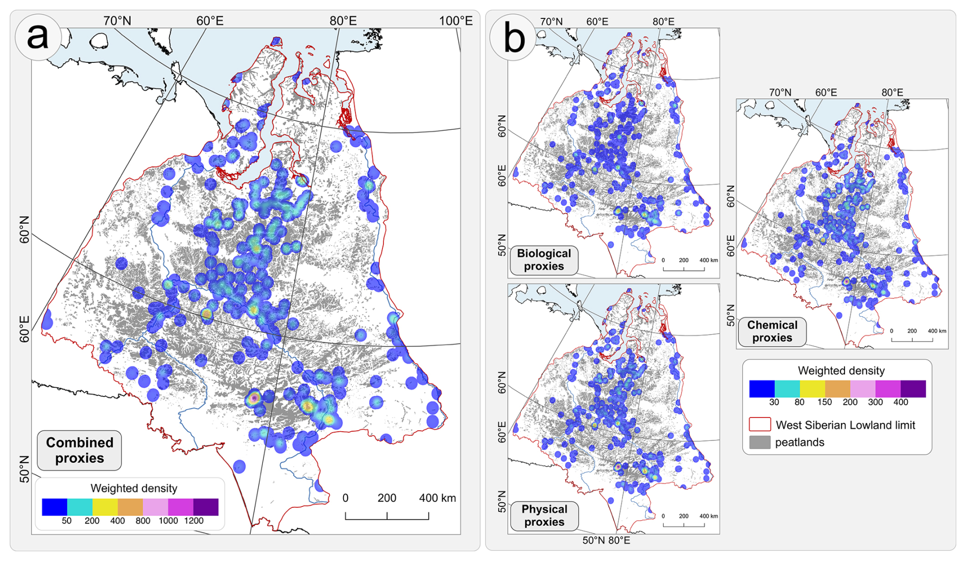
Figure 10Spatial representation of peatland areas in Western Siberian Lowland sampled by peat cores and their relative contribution of information: (a) heatmap of combined scores of all proxy types, and (b) heatmaps of proxy group scores (biological, chemical, and physical). Heatmaps were generated using Kernel Density Estimation, with a 30 km radius, assuming each core represents the surrounding of 30 km, and weighted by the combined or group-specific scores to depict relative data density. Peat core scoring was based on both chronology and proxies.
These limitations are especially critical given the global climatic importance of WSL peatlands. The WSL stores one of the largest peat carbon pools on Earth (Hugelius et al., 2020; Kremenetski et al., 2003; Sheng et al., 2004) and acts both as a long-term carbon sink and a major methane source (Kirpotin et al., 2009; MacDonald et al., 2006; Smith et al., 2004), while ongoing climate change drives complex, regionally variable shifts in ecosystem functioning (Halaś et al., 2025; Zhang et al., 2022). In the context of global soil carbon and peatland assessments (Scharlemann et al., 2014), reducing spatial and methodological gaps in this region is therefore essential for both understanding local processes and improving global C–CH4 budgets.
Looking ahead, the patterns revealed by the WSPC database suggest clear priorities. Continuous and sporadic permafrost zones, especially beyond major river corridors and well-studied complexes such as the Great Vasyugan Mire, should be key targets for new coring campaigns (Fig. 10a). In addition, some areas that appear well covered in terms of core numbers are represented mainly by low-resolution, single-proxy records based on older methods; where detailed reconstructions of hydrology, fire regimes or carbon dynamics are needed, such sites should be revisited or re-analysed using modern, high-resolution multi-proxy approaches. Future work would benefit from wider use of underrepresented biological proxies (e.g. testate amoebae, macro- and microcharcoal, non-pollen palynomorphs) and advanced geochemical and isotopic analyses, particularly in permafrost-affected peatlands (Fig. 10b).
At the same time, overcoming logistical and political barriers will require new collaboration and field strategies, including closer partnerships with regional institutions and local communities, greater use of remote sensing and existing infrastructure to pre-select coring sites, and flexible multi-site expeditions using lighter, easily deployable equipment. Aligning such practical solutions with the spatial and methodological gaps highlighted by the WSPC database will allow future research in WSL to move beyond opportunistic sampling towards systematically planned, hypothesis-driven studies that better capture the diversity and dynamics of WSL peatlands.
-
Incomplete coverage of literature sources – the database is based on a literature review of available repositories, which may be missing some publications. The authors acknowledge that not all studies presenting peat core data from the region were identified or accessible.
-
Limited access to Russian-language literature published before 1990 – most pre-1990 Russian-language publications were not available in open-access repositories. As a result, some original sources could not be obtained, limiting the ability to gather comprehensive information on peat cores and proxy usage. Consequently, certain proxies may have been applied earlier or more frequently than indicated by this database.
-
Uncertainty related to incomplete reporting in key studies – some works provided aggregated descriptions of coring efforts without reporting exact locations of individual cores. For example, Lapshina and Zarov (2023) described 355 sampling cores along hypsometric profiles, yet precise coordinates were not provided, allowing only 76 cores to be included in this database. It remains possible that many of these cores overlap with records included in other compilations (e.g., Hugelius et al., 2020), but this could not be verified.
-
Ambiguity in reporting complete basal peat sequences – in most cases the oldest core from a study site represents a basal core; however, some publications did not clearly specify whether a core reached the mineral substrate. This ambiguity may introduce minor uncertainty into the interpretation of basal depths included in the database.
-
Existence of unpublished data – some peat cores are known to exist (e.g., from reports, institutional archives, or personal communications), but lack published stratigraphic or proxy data. These could not be incorporated into the database.
-
Variable spatial precision of reported core locations – many older or regionally published studies provide only approximate locations (e.g., mire name or nearest settlement) rather than precise coordinates. As a result, included cores differ in coring location accuracy.
-
Dependence on secondary sources for inaccessible studies – when original publications, particularly older Russian-language works, were unavailable, information was obtained from secondary citations in later papers. This reliance on indirect sources may introduce errors. For example, Liss and Berezina (1981) published stratigraphic diagrams with several dated levels within single core, but in later studies these levels were misinterpreted as separate basal cores. Such discrepancies highlight the risk of propagating mistakes when direct access to original materials is not possible.
-
Potential duplication or omission of cores – some cores appear repeatedly across multiple publications, yet lack of precise metadata sometimes prevented determining whether two references referred to the same core. This introduces a small risk of either under- or over-counting cores.
The data are available on the Zenodo platform at the following link: https://doi.org/10.5281/zenodo.20323517 (Halaś and Słowiński, 2026). We plan to expand this database in the future by providing a submission form that will allow researchers to contribute additional peat cores, either from new studies or from existing collections not yet included in the database.
The Western Siberian Peat Core Database (WSPC) provides a harmonized and georeferenced dataset of peat cores that greatly advances the capacity for regional analyses of Holocene environmental change in the Western Siberian Lowland (WSL). The literature review demonstrates a clear progression in WSL peatland research, from early single-proxy and low-resolution studies to modern multi-proxy approaches with higher chronological and analytical precision. Increasing attention to peatland hydrology, fire history, and carbon accumulation reflects both methodological developments and a growing recognition of the crucial ecological and climatic importance of WSL peatlands. The WSPC database integrates metadata from 654 georeferenced peat cores or cross-sections reported in 156 publications (1953–2025), documenting application of 26 palaeoecological proxies across biological, physical, chemical, and chronological categories. Spatial analyses reveal a concentration of sampling along major rivers (Ob, Yenisey, Irtysh, Tobol) and in the Great Vasyugan Mire, reflecting both the extent of peatlands and relative accessibility. Most cores originate from non-permafrost and discontinuous permafrost zones, whereas continuous permafrost regions remain poorly sampled. Temporal coverage varies substantially: ∼ 80 % of cores span the last 4000 years, ∼ 50 % extend to 8000 years, and only a limited number reach the Late Glacial (∼ 15 600 cal. yr BP), with the longest and most continuous records found in non-permafrost and isolated permafrost zones. Overall, the dataset shows a strong dominance of fundamental physical and chemical proxies, particularly basal depth, carbon accumulation, and organic matter content, which underscores their central role in peatland palaeoecology. Biological proxies such as plant macrofossils, pollen, and testate amoebae are applied more selectively and largely depend on specific research goals, while specialized chemical proxies (e.g., traditional geochemical analysis, FTIR, XRF, stable isotopes) remain infrequently used. This distribution highlights both the breadth of existing multi-proxy approaches and the clear gaps in the application of biological and advanced geochemical methods. Collectively, this database provides an essential foundation for large-scale reconstructions of Holocene peatland development, hydrology, fire regimes, and carbon dynamics, while clearly identifying spatial and proxy-specific gaps. Several limitations must be acknowledged, including incomplete access to older Russian-language literature, inconsistent reporting of complete basal peat sequences, variable spatial precision of core locations, reliance on secondary sources, and the existence of unpublished or inaccessible core data. These factors introduce minor uncertainties and may lead to under- or overrepresentation of some cores or proxies. Despite these constraints, the WSPC database constitutes a valuable and robust resource for regional and pan-WSL palaeoenvironmental research. At the same time, it highlights key spatial, temporal, and methodological gaps and provides clear guidance for future research priorities, particularly regarding the limited coverage of northern regions, the uneven application of different proxies, and the logistical challenges associated with fieldwork in the WSL peatlands.
Table A1Proxies used in palaeoecological peatland studies in Western Siberia Lowland (WSL) included in the Western Siberian Peat Cores Database (WSPC).
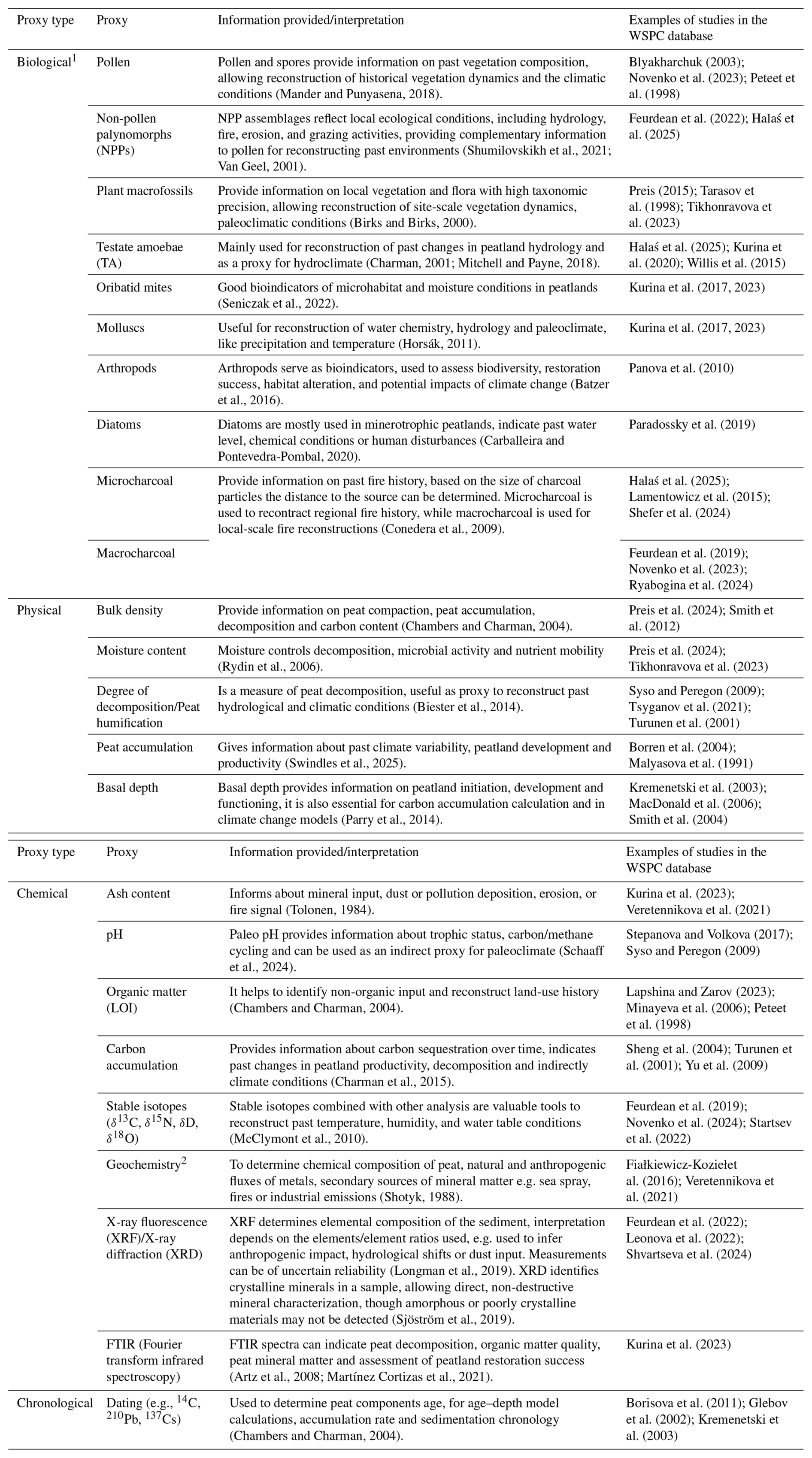
1 Among the biological proxies, a category termed “zoogenic remains” was also distinguished, which was used in the context of the study by Paradossky et al. (2019). In that study, the authors identified general groups of zoogenic remains rather than specific taxa. 2 General group of analysis applied on peat core excluding stable isotopes, XRF and FTIR.
Table A2Results of calibration of uncalibrated radiocarbon ages (yr BP) for peat cores in Western Siberian Peat Cores Database (WSPC) with reference to the source of original (uncalibrated) ages.
Table A3Proxy groups and individual proxy weights used in the scoring framework.
Table A4Components of scoring framework for peat cores in WSPC database.
, where: S – score, W – weight
Figure B1Spatial distribution of peat cores included in the Western Siberian Peat Core Database with records of proxies: (a) radiocarbon dating, (b) basal depth, (c) bulk density, (d) degree of decomposition, (e) moisture content, (f) peat accumulation, (g) peat humification, (h) plant macrofossils, (i) pollen, (j) macrocharcoal, (k) testate amoebae, (l) microcharcoal, (m) non-pollen palynomorphs, (n) diatoms, (o) oribatid, (p) arthropod peat humification, (q) mollusc, (r) zoogenic remains, (s) carbon accumulation, (t) ash content, (u) organic matter, (v) geochemistry, (w) pH, (x) stable isotopes, (y) XRF (X-ray fluorescence)/XRD (X-ray diffraction), (z) FTIR (Fourier transform infrared spectroscopy). * In one core (located in the north), diatoms were applied only on the lake section of the core below the peat.
AH designed the research, conducted the literature review, compiled the database, wrote the original draft of the manuscript and led the revision process, including preparing the responses to the reviewers' comments and implementing the manuscript and database corrections. MS contributed to the research design, supervised the project, revised the manuscript, contributed to the writing, and participated in responding to the reviewers' comments and manuscript corrections.
The contact author has declared that neither of the authors has any competing interests.
Publisher's note: Copernicus Publications remains neutral with regard to jurisdictional claims made in the text, published maps, institutional affiliations, or any other geographical representation in this paper. The authors bear the ultimate responsibility for providing appropriate place names. Views expressed in the text are those of the authors and do not necessarily reflect the views of the publisher.
We would like to sincerely thank the reviewers of this manuscript, Sebastian Wetterich and the anonymous Reviewer #1, for their valuable comments and constructive suggestions. The manuscript and database were substantially improved as a result of their feedback.
The research has been supported by the National Science Centre in Poland (grant no. 2019/35/O/ST10/02903).
This paper was edited by Birgit Heim and reviewed by Sebastian Wetterich and one anonymous referee.
Alexandrov, G. A., Brovkin, V. A., and Kleinen, T.: The influence of climate on peatland extent in Western Siberia since the Last Glacial Maximum, Sci. Rep., 6, 24784, https://doi.org/10.1038/srep24784, 2016.
Artz, R. R. E., Chapman, S. J., Jean Robertson, A. H., Potts, J. M., Laggoun-Défarge, F., Gogo, S., Comont, L., Disnar, J.-R., and Francez, A.-J.: FTIR spectroscopy can be used as a screening tool for organic matter quality in regenerating cutover peatlands, Soil Biol. Biochem., 40, 515–527, https://doi.org/10.1016/j.soilbio.2007.09.019, 2008.
Barber, K. E.: Peatlands as scientific archives of past biodiversity, Biodivers. Conserv., 2, 474–489, https://doi.org/10.1007/BF00056743, 1993.
Baryshnikov, M. K.: Carex-Hypnum Bogs of the West Vasuganye, Moscow, 37 pp., 1929.
Batzer, D., Wu, H., Wheeler, T., and Eggert, S.: Peatland Invertebrates, in: Invertebrates in Freshwater Wetlands: An International Perspective on their Ecology, edited by: Batzer, D. and Boix, D., Springer International Publishing, Cham, 219–250, https://doi.org/10.1007/978-3-319-24978-0_7, 2016.
Beck, H. E., Zimmermann, N. E., McVicar, T. R., Vergopolan, N., Berg, A., and Wood, E. F.: Present and future Köppen-Geiger climate classification maps at 1-km resolution, Sci. Data, 5, 180214, https://doi.org/10.1038/sdata.2018.214, 2018.
Biester, H., Knorr, K.-H., Schellekens, J., Basler, A., and Hermanns, Y.-M.: Comparison of different methods to determine the degree of peat decomposition in peat bogs, Biogeosciences, 11, 2691–2707, https://doi.org/10.5194/bg-11-2691-2014, 2014.
Birks, H. H. and Birks, H. J. B.: Future Uses of Pollen Analysis Must Include Plant Macrofossils, J. Biogeogr., 27, 31–35, 2000.
Blyakharchuk, T.: Four new pollen sections tracing the Holocene vegetational development of the southern part of the West Siberan Lowland, Holocene, 13, 715–731, https://doi.org/10.1191/0959683603hl658rp, 2003.
Blyakharchuk, T. A., Kurina, I. V., and Pologova, N. N.: Pozdnegolotsenovaya dinamika rastitel'nogo pokrova i uvlazhnennosti klimata yugo-vostochnogo sektora Zapadno-Sibirskoy ravniny po dannym palinologicheskogo i rizopodnogo issledovaniy torfyanykh otlozheniy [Late Holocene dynamics of vegetation cover and climate humidity in the southeastern sector of the West Siberian Plain based on palynological and rhizopod studies of peat deposits], Bull. Tomsk State Univ. Biol., 164–189, https://doi.org/10.17223/19988591/45/9, 2019.
Borisova, O. K., Novenko, E. Y., Zelikson, E. M., and Kremenetski, K. V.: Lateglacial and Holocene vegetational and climatic changes in the southern taiga zone of West Siberia according to pollen records from Zhukovskoye peat mire, Quat. Int., 237, 65–73, https://doi.org/10.1016/j.quaint.2011.01.015, 2011.
Borren, W., Bleuten, W., and Lapshina, E. D.: Holocene peat and carbon accumulation rates in the southern taiga of western Siberia, Quat. Res., 61, 42–51, https://doi.org/10.1016/j.yqres.2003.09.002, 2004.
Botch, M. S. and Masing, V. V.: Mire ecosystems in the USSR, in: Ecosystems of the World, vol. 4A, Mires: Swamp, Bog, Fen and Moor, edited by: Gore, A. J. P., Elsevier Science, New York, 95–152, ISBN 0444420037, 1983.
Botch, M. S., Kobak, K. I., Vinson, T. S., and Kolchugina, T. P.: Carbon pools and accumulation in peatlands of the former Soviet Union, Glob. Biogeochem. Cycles, 9, 37–46, https://doi.org/10.1029/94GB03156, 1995.
Bronzov, A. Y.: Verkhovye bolota Narymskogo kraya (bassein reki Vasiugan) [Bogs of the Narymski region (watershed of the Vasiugan River)], Proc. Peat Inst., 3, 1–100, 1930.
Brown, J., Ferrians, O., Heginbottom, J. A., and Melnikov, E.: Circum-Arctic Map of Permafrost and Ground-Ice Conditions (2), National Snow and Ice Data Center [data set], https://doi.org/10.7265/SKBG-KF16, 2002.
Carballeira, R. and Pontevedra-Pombal, X.: Diatoms in Paleoenvironmental Studies of Peatlands, Quaternary, 3, 10, https://doi.org/10.3390/quat3020010, 2020.
Chambers, F. M. and Charman, D. J.: Holocene environmental change: contributions from the peatland archive, The Holocene, 14, 1–6, https://doi.org/10.1191/0959683604hl684ed, 2004.
Charman, D.: Biostratigraphic and palaeoenvironmental applications of testate amoebae, Quaternary Sci. Rev., 20, 1753–1764, https://doi.org/10.1016/S0277-3791(01)00036-1, 2001.
Charman, D. J., Amesbury, M. J., Hinchliffe, W., Hughes, P. D. M., Mallon, G., Blake, W. H., Daley, T. J., Gallego-Sala, A. V., and Mauquoy, D.: Drivers of Holocene peatland carbon accumulation across a climate gradient in northeastern North America, Quaternary Sci. Rev., 121, 110–119, https://doi.org/10.1016/j.quascirev.2015.05.012, 2015.
Conedera, M., Tinner, W., Neff, C., Meurer, M., Dickens, A. F., and Krebs, P.: Reconstructing past fire regimes: methods, applications, and relevance to fire management and conservation, Quaternary Sci. Rev., 28, 555–576, https://doi.org/10.1016/j.quascirev.2008.11.005, 2009.
Dranitsyn, D. A.: Secondary podzols and the shift in the podzol zone in the northern part of the Ob'-Irtysh watershed, Proc. Dokuchaev Soil Comm., 2, 33–93, 1914.
Duchkov, A. D.: Characteristics of permafrost in Siberia, in: Advances in the Geological Storage of Carbon Dioxide, 81–91, https://doi.org/10.1007/1-4020-4471-2_08, 2006.
Efremov, S. P. and Efremova, T. T.: Present stocks of peat and organic carbon in bog ecosystems of west Siberia, in: Carbon Storage and Atmospheric Exchange by West Siberian Peatlands, Utrecht Univ., Utrecht, Netherlands, 73–78, 2001.
Feurdean, A., Gałka, M., Florescu, G., Diaconu, A.-C., Tanţău, I., Kirpotin, S., and Hutchinson, S. M.: 2000 years of variability in hydroclimate and carbon accumulation in western Siberia and the relationship with large-scale atmospheric circulation: A multi-proxy peat record, Quaternary Sci. Rev., 226, 105948, https://doi.org/10.1016/j.quascirev.2019.105948, 2019.
Feurdean, A., Diaconu, A.-C., Pfeiffer, M., Gałka, M., Hutchinson, S. M., Butiseaca, G., Gorina, N., Tonkov, S., Niamir, A., Tantau, I., Zhang, H., and Kirpotin, S.: Holocene wildfire regimes in western Siberia: interaction between peatland moisture conditions and the composition of plant functional types, Clim. Past, 18, 1255–1274, https://doi.org/10.5194/cp-18-1255-2022, 2022.
Fiałkiewicz-Kozieł, B., Smieja-Król, B., Frontasyeva, M., Słowiński, M., Marcisz, K., Lapshina, E., Gilbert, D., Buttler, A., Jassey, V. E. J., Kaliszan, K., Laggoun-Défarge, F., Kołaczek, P., and Lamentowicz, M.: Anthropogenic- and natural sources of dust in peatland during the Anthropocene, Sci. Rep., 6, 38731, https://doi.org/10.1038/srep38731, 2016.
Glavtorffond RSFSR: Torfianye mestorozhdenia Zapadnoi Sibiri [Peat Deposits in Western Siberia], Glavtorffond RSFSR, Moscow, 1956.
Glebov, F. Z., Toleyko, L. S., Starikov, E. V., and Zhidovlenko, V. A.: Palinologicheskaya kharakteristika i datirovanie po 14C torfyanika v Aleksandrovskom rayone Tomskoy oblasti (srednetaezhnaya podzona) [Palynology and 14C dating of a peat bog from the Aleksandrovsk district of Tomskregion (middle taiga sub-belt)], in: Tipy bolot SSSR i printsipy ikh klassifikatsii [Types of the USSR Bogs and Principles of their Classification], Nauka, Leningrad, 194–199, 1974.
Glebov, F. Z., Karpenko, L. V., and Dashkovskaya, I. S.: Climatic Changes, Successions of Peatlands and Zonal Vegetation, and Peat Accumulation Dynamics in the Holocene (the West-Siberia Peat Profile “Vodorasdel”), Clim. Change, 55, 175–181, https://doi.org/10.1023/A:1020216922975, 2002.
Gordiagin, A. Y.: Data to know about soils and vegetation of West Siberia, Proc. Nat. Soc. Kazan Univ., 34, 222, 1901.
Gorodkov, B. N.: Permafrost in the Northern Area, Leningrad, 109 pp., 1932.
Govorukhin, V. S.: Vegetation of the summer pasture area of reindeer, Zemlevedenie, 35, 68–92, 1933.
Greifswald Mire Centre: Global Peatland Map 2.0. Underlying dataset of the UNEP Global Peatland Assessment – The State of the World's Peatlands: Evidence for action toward the conservation, restoration, and sustainable management of peatlands, Global Peatlands Initiative, https://nextcloud.uni-greifswald.de/public.php/dav/files/s7Ln5QKxdQG5aaA/?accept=zip (last access: 3 June 2026), 2022.
Halaś, A. and Słowiński, M.: Western Siberian Peat Core Database (WSPC), Zenodo [data set], https://doi.org/10.5281/zenodo.20323517, 2026.
Halaś, A., Lamentowicz, M., Obremska, M., Łuców, D., and Słowiński, M.: Peatland development reconstruction and complex biological responses to permafrost thawing in Western Siberia, Biogeosciences, 22, 4797–4822, https://doi.org/10.5194/bg-22-4797-2025, 2025.
Haslett, J. and Parnell, A. C.: A simple monotone process with application to radiocarbon-dated depth chronologies, J. R. Stat. Soc. Ser. C Appl. Stat., 57, 399–418, 2008.
Horsák, M.: Mollusc assemblages in palaeoecological reconstructions: an investigation of their predictive power using transfer function models, Boreas, 40, 459–467, https://doi.org/10.1111/j.1502-3885.2010.00195.x, 2011.
Hugelius, G., Loisel, J., Chadburn, S., Jackson, R. B., Jones, M., MacDonald, G., Marushchak, M., Olefeldt, D., Packalen, M., Siewert, M. B., Treat, C., Turetsky, M., Voigt, C., and Yu, Z.: Large stocks of peatland carbon and nitrogen are vulnerable to permafrost thaw, P. Natl. Acad. Sci. USA, 117, 20438–20446, https://doi.org/10.1073/pnas.1916387117, 2020.
Ivanov, K. E. and Novikov, S. M.: Bolota Zapadnoi Sibiri, ikh stroenie i gidrologicheskiy rezhim [Bogs of West Siberia, their structure and hydrology], Gidrometeoizdat, Leningrad, 447 pp., 1976.
Khotinsky, N. A.: Holocene vegetation history, in: Late Quaternary Environments of the Soviet Union, ISBN 978-0-8166-1250-5, 1984.
Kirpotin, S. N., Berezin, A., Bazanov, V., Polishchuk, Y., Vorobiov, S., Mironycheva-Tokoreva, N., Kosykh, N., Volkova, I., Dupre, B., Pokrovsky, O., Kouraev, A., Zakharova, E., Shirokova, L., Mognard, N., Biancamaria, S., Viers, J., and Kolmakova, M.: Western Siberia wetlands as indicator and regulator of climate change on the global scale, Int. J. Environ. Stud., 66, 409–421, https://doi.org/10.1080/00207230902753056, 2009.
Kremenetski, K. V., Velichko, A. A., Borisova, O. K., MacDonald, G. M., Smith, L. C., Frey, K. E., and Orlova, L. A.: Peatlands of the Western Siberian lowlands: current knowledge on zonation, carbon content and Late Quaternary history, Quaternary Sci. Rev., 22, 703–723, https://doi.org/10.1016/S0277-3791(02)00196-8, 2003.
Kurakova, A. A.: Landscape-Hydrological Zoning of the Flat Areas of Western Siberia and Its Application in the Analysis of River Bank Erosion, Geogr. Nat. Resour., 45, 397–409, https://doi.org/10.1134/S1875372824700720, 2024.
Kurina, I. V., Veretennikova, E. E., Salisch, L. V., Egorova, M. L., Dolgin, V. N., Udaloi, A. V., and Golovatskaya, E. A.: Primenenie zooindikatorov dlya rekonstruktsii usloviy prirodnoy sredy golotsena v torfyanoy zalezhi nizinnogo bolota [The use of zoo-indicators for the reconstruction of paleoenvironments in the Holocene in the peat deposits of an eutrophic peatland], Zool. Zhurnal, 96, 973–986, https://doi.org/10.7868/S0044513417080086, 2017.
Kurina, I. V., Li, H., and Barashkov, D. R.: Use of testate amoebae to infer paleohydrology during fen and fen-bog transition stages of ombrotrophic mire development, J. Paleolimnol., 63, 147–158, https://doi.org/10.1007/s10933-019-00107-y, 2020.
Kurina, I. V., Veretennikova, E. E., Il'ina, A. A., Egorova, M. L., Salisch, L. V., Dolgin, V. N., Udaloi, A. V., Golovatskaya, E. A., Dyukarev, E. A., and Smirnov, S. V.: Multi-proxy climate and environmental records from a Holocene eutrophic mire, southern taiga subzone, West Siberia, Boreas, 52, 223–239, https://doi.org/10.1111/bor.12604, 2023.
Lamentowicz, M., Słowiński, M., Marcisz, K., Zielińska, M., Kaliszan, K., Lapshina, E., Gilbert, D., Buttler, A., Fiałkiewicz-Kozieł, B., Jassey, V. E. J., Laggoun-Defarge, F., and Kołaczek, P.: Hydrological dynamics and fire history of the last 1300 years in western Siberia reconstructed from a high-resolution, ombrotrophic peat archive, Quat. Res., 84, 312–325, https://doi.org/10.1016/j.yqres.2015.09.002, 2015.
Lapshina, E. D. and Zarov, E. A.: Stratigraphy of peat deposits and mire development in the southernpart of the forest zone of Western Siberia in Holocene., Environ. Dyn. Glob. Clim. Change, 14, 70–101, https://doi.org/10.18822/edgcc568688, 2023.
Leonova, G. À., Maltsev, À. Å., Preis, Y. I., and Miroshnichenko, L. V.: Biogeochemistry of holocene peatlands in the baraba forest-steppe (southern West Siberia), Appl. Geochem., 124, 104811, https://doi.org/10.1016/j.apgeochem.2020.104811, 2021.
Leonova, G. A., Maltsev, A. E., Preis, Y. I., Miroshnichenko, L. V., Shavekin, A. S., and Rubanov, M. V.: Biogeochemical Features of Holocene Sediments in Oligotrophic Bogs of the Baraba Forest Steppe, Geochem. Int., 60, 183–202, https://doi.org/10.1134/S0016702922020069, 2022.
Levkovskaya, G. M., Kind, N. V., Zavelsky, F. C., and Forova, V. S.: Absolute age of peat bogs of the Igarka City region and the division of the West Siberia Holocene, Bull. Comm. Quat. Stud., 37, 94–101, 1970.
Liss, O. L. and Berezina, N.: Bolotnye sistemy Zapadnoy Sibiri [Bogs of the West Siberian Lowland], Moscow University publishing, Moscow, 206 pp., ISBN 5-8125-0150-5, 1981.
Liss, O. L. and Kulikova, G. G.: About the regional classification of bogs in Tomsk region, Vestn. Mosk. Univ., 4, 87–91, 1967.
Loisel, J., Yu, Z., Beilman, D. W., Camill, P., Alm, J., Amesbury, M. J., Anderson, D., Andersson, S., Bochicchio, C., Barber, K., Belyea, L. R., Bunbury, J., Chambers, F. M., Charman, D. J., De Vleeschouwer, F., Fiałkiewicz-Kozieł, B., Finkelstein, S. A., Gałka, M., Garneau, M., Hammarlund, D., Hinchcliffe, W., Holmquist, J., Hughes, P., Jones, M. C., Klein, E. S., Kokfelt, U., Korhola, A., Kuhry, P., Lamarre, A., Lamentowicz, M., Large, D., Lavoie, M., MacDonald, G., Magnan, G., Mäkilä, M., Mallon, G., Mathijssen, P., Mauquoy, D., McCarroll, J., Moore, T. R., Nichols, J., O'Reilly, B., Oksanen, P., Packalen, M., Peteet, D., Richard, P. J., Robinson, S., Ronkainen, T., Rundgren, M., Sannel, A. B. K., Tarnocai, C., Thom, T., Tuittila, E.-S., Turetsky, M., Väliranta, M., van der Linden, M., van Geel, B., van Bellen, S., Vitt, D., Zhao, Y., and Zhou, W.: A database and synthesis of northern peatland soil properties and Holocene carbon and nitrogen accumulation, The Holocene, 24, 1028–1042, https://doi.org/10.1177/0959683614538073, 2014.
Longman, J., Veres, D., and Wennrich, V.: Utilisation of XRF core scanning on peat and other highly organic sediments, Quatern. Int., 514, 85–96, https://doi.org/10.1016/j.quaint.2018.10.015, 2019.
López-Blanco, E., Topp-Jørgensen, E., Christensen, T. R., Rasch, M., Skov, H., Arndal, M. F., Bret-Harte, M. S., Callaghan, T. V., and Schmidt, N. M.: Towards an increasingly biased view on Arctic change, Nat. Clim. Change, 14, 152–155, https://doi.org/10.1038/s41558-023-01903-1, 2024.
L'vov, Y. A.: Metodicheskie materialy k tipologii i klassifikatsii bolot Tomskoy oblasti [Methodical materials for the typology and classification of the Tomsk Province mires], in: Tipy bolot SSSR i printsipy ikh klassifikatsii [Types of the USSR Bogs and Principles of their Classification], Nauka, Leningrad, 188–194, 1974.
MacDonald, G. M., Beilman, D. W., Kremenetski, K. V., Sheng, Y., Smith, L. C., and Velichko, A. A.: Rapid Early Development of Circumarctic Peatlands and Atmospheric CH4 and CO2 Variations, Science, 314, 285–288, https://doi.org/10.1126/science.1131722, 2006.
Malyasova, E. S., Novikov, S. M., and Usova, L. I.: Dynamics of peat accumulation and the formation of palsa mires in the Western Siberia, Bot. Zhurnal, 9, 1227–1238, 1991.
Mander, L. and Punyasena, S. W.: Fossil Pollen and Spores in Paleoecology, in: Methods in Paleoecology: Reconstructing Cenozoic Terrestrial Environments and Ecological Communities, edited by: Croft, D. A., Su, D. F., and Simpson, S. W., Springer International Publishing, Cham, 215–234, https://doi.org/10.1007/978-3-319-94265-0_11, 2018.
Map of West Siberian wetlands: Karta bolot Zapadnoi Sibiri, Moscow: Main Administration of Geodesy and Cartography, 1970.
Map of West Siberian wetlands: Karta bolot Zapadnoi Sibiri, Omsk, 1996.
Martínez Cortizas, A., López-Merino, L., Silva-Sánchez, N., Sjöström, J. K., and Kylander, M. E.: Investigating the Mineral Composition of Peat by Combining FTIR-ATR and Multivariate Analysis, Minerals, 11, 1084, https://doi.org/10.3390/min11101084, 2021.
McClymont, E. L., Pendall, E., and Nichols, J.: Stable isotopes and organic geochemistry in peat: Tools to investigate past hydrology, temperature and biogeochemistry, PAGES News, 18, 15–18, https://doi.org/10.22498/pages.18.1.15, 2010.
Minayeva, T., Bleuten, W., Sirin, A., and Lapshina, E. D.: Eurasian Mires of the Southern Taiga Belt: Modern Features and Response to Holocene Palaeoclimate, in: Wetlands and Natural Resource Management, edited by: Verhoeven, J. T. A., Beltman, B., Bobbink, R., and Whigham, D. F., Springer, Berlin, Heidelberg, 315–341, https://doi.org/10.1007/978-3-540-33187-2_14, 2006.
Mitchell, E. A. D.: A brief history of testate amoebae research and introducing the International Society for Testate Amoeba Research (ISTAR), Acta Protozool., 2024, 1–14, 2025.
Mitchell, E. A. D. and Payne, R.: Testate Amoeba Analysis, in: The Encyclopedia of Archaeological Sciences, 1–4, https://doi.org/10.1002/9781119188230.saseas0576, 2018.
Neustadt, M. I.: On absolute age of peat bogs of Western Siberia., Rev. Roum. Biol. Ser. Bot., 12, 181–186, 1967.
Neustadt, M. I.: The world natural phenomenon – Bogs of the West Siberian Lowland, Izv. Akad. Nauk SSSR, 21–34, 1971.
Neustadt, M. I.: Holocene peatland development, in: Late Quaternary Environments of the Soviet Union, University of Minnesota Press, Minneapolis, 201–206, ISBN 0-8166-1250-1, 1984.
Novenko, E., Rudenko, O., Mazei, N., Kupriyanov, D., Andreev, R., Shatunov, A., Kusilman, M., Prokushkin, A., and Olchev, A.: Effects of Climate Change and Fire on the Middle and Late Holocene Forest History in Yenisei Siberia, Forests, 14, 2321, https://doi.org/10.3390/f14122321, 2023.
Novenko, E. Y., Mazei, N. G., Kupriyanov, D., Shatunov, A. E., Andreev, R. A., Makarova, E. A., Borodina, K. A., Rudenko, O., Prokushkin, A. S., and Volkova, E. M.: Izmeneniya rastitel'nosti Prieniseyskoy Sibiri v poslednie 4700 let: novye paleoekologicheskie dannye iz rayona Igarki (Krasnoyarskiy kray) [Vegetation changes in Yenisei Siberia over the last 4700 years: new palaeoecological data from Igarka area; Krasnoyarsk Region], Geomorfologiya, 53, 5–6, https://doi.org/10.31857/S0435428122030129, 2022.
Novenko, E. Y., Prokushkin, A. S., Mazei, N. G., Zazovskaya, E. P., Kupriyanov, D. A., Shatunov, A. E., Andreev, R. A., Makarova, E. A., Kusilman, M. V., Serikov, S. I., Xiuyuan, G., Babeshko, K. V., Tsyganov, A. N., and Mazei, Y. A.: The mid- and late Holocene palsa palaeoecology and hydroclimatic changes in Yenisei Siberia revealed by a high-resolution peat archive, Quat. Int., 682, 8–21, https://doi.org/10.1016/j.quaint.2024.01.013, 2024.
Olson, D. M., Dinerstein, E., Wikramanayake, E. D., Burgess, N. D., Powell, G. V. N., Underwood, E. C., D'amico, J. A., Itoua, I., Strand, H. E., Morrison, J. C., Loucks, C. J., Allnutt, T. F., Ricketts, T. H., Kura, Y., Lamoreux, J. F., Wettengel, W. W., Hedao, P., and Kassem, K. R.: Terrestrial Ecoregions of the World: A New Map of Life on Earth: A new global map of terrestrial ecoregions provides an innovative tool for conserving biodiversity, Bioscience, 51, 933–938, https://doi.org/10.1017/S0033822200033695, 2001.
Olsson, I. U.: Radiocarbon Dating History: Early Days, Questions, and Problems Met, Radiocarbon, 51, 1–43, https://doi.org/10.1017/S0033822200033695, 2009.
Panova, N. K., Trofimova, S. S., Antipina, T. G., Zinoviev, E. V., Gilev, A. V., and Erokhin, N. G.: Holocene dynamics of vegetation and ecological conditions in the southern Yamal Peninsula according to the results of comprehensive analysis of a relict peat bog deposit, Russ. J. Ecol., 41, 20–27, https://doi.org/10.1134/S1067413610010042, 2010.
Paradossky, V. L., Pechatnova, Y. V., and Solomonova, M. Y.: The natural transformations of the Northern Kulunda in the second half of the Holocene based on studying the microbiomorphic profile of swampy phytocenosis, Ukr. J. Ecol., 9, 406–411, 2019.
Parry, L. E., West, L. J., Holden, J., and Chapman, P. J.: Evaluating approaches for estimating peat depth, J. Geophys. Res.-Biogeo., 119, 567–576, https://doi.org/10.1002/2013JG002411, 2014.
Peteet, D., Andreev, A., Bardeen, W., and Mistretta, F.: Long-term Arctic peatland dynamics, vegetation and climate history of the Pur-Taz region, Western Siberia, Boreas, 27, 115–126, https://doi.org/10.1111/j.1502-3885.1998.tb00872.x, 1998.
Polishchuk, Y. M., Bogdanov, A. N., Polishchuk, V. Y., Manasypov, R. M., Shirokova, L. S., Kirpotin, S. N., and Pokrovsky, O. S.: Size Distribution, Surface Coverage, Water, Carbon, and Metal Storage of Thermokarst Lakes in the Permafrost Zone of the Western Siberia Lowland, Water, 9, 228, https://doi.org/10.3390/w9030228, 2017.
Preis, Y.: Indicators of paleocryogenic processes that disrupt the patterns of peatland autogenic development in the zone of seasonal freezing of rocks of Western Siberia, Limnol. Freshw. Biol., 562–567, https://doi.org/10.31951/2658-3518-2024-A-4-562, 2024.
Preis, Y., Maltsev, A., and Leonova, G.: Assessment of Holocene climate influence on hydrothermal regime of paleoecotopes within Ryams of the Baraba forest-steppe (southern Western Siberia), Limnol. Freshw. Biol., 580–587, https://doi.org/10.31951/2658-3518-2024-A-4-580, 2024.
Preis, Y. I.: Detal'naya rekonstruktsiya funktsional'nogo sostoyaniya bolota kak otklik na izmeneniya kontinental'nogo klimata golotsena (srednyaya tayga Zapadnoy Sibiri) [Detailed reconstruction of bog functional state as a response to continental climate changes in Holocene (the middle taiga of Western Siberia)], News Tomsk Polytech. Univ. Eng. Georesources, 326, 90–102, 2015.
Punning, J. M., Kakum, T., and Rajamäe, R.: Tallinn Radiocarbon Dates II, Radiocarbon, 16, 388–394, https://doi.org/10.1017/S0033822200059683, 1974.
Pupysheva, M. A. and Blyakharchuk, T. A.: Fires and their Significance in the Earth's Post-Glacial Period: a Review of Methods, Achievements, Groundwork, Contemp. Probl. Ecol., 16, 303–315, https://doi.org/10.1134/S1995425523030095, 2023.
QGIS Development Team: QGIS Geographic Information System, Zenodo, https://doi.org/10.5281/zenodo.6139224, 2025.
R Core Team: R: A Language and Environment for Statistical Computing, R Foundation for Statistical Computing, Vienna, Austria, https://www.R-project.org/ (last access: 3 June 2026), 2022.
Reimer, P. J., Austin, W. E. N., Bard, E., Bayliss, A., Blackwell, P. G., Ramsey, C. B., Butzin, M., Cheng, H., Edwards, R. L., Friedrich, M., Grootes, P. M., Guilderson, T. P., Hajdas, I., Heaton, T. J., Hogg, A. G., Hughen, K. A., Kromer, B., Manning, S. W., Muscheler, R., Palmer, J. G., Pearson, C., Plicht, J. V. D., Reimer, R. W., Richards, D. A., Scott, E. M., Southon, J. R., Turney, C. S. M., Wacker, L., Adolphi, F., Büntgen, U., Capano, M., Fahrni, S. M., Fogtmann-Schulz, A., Friedrich, R., Köhler, P., Kudsk, S., Miyake, F., Olsen, J., Reinig, F., Sakamoto, M., Sookdeo, A., and Talamo, S.: The IntCal20 Northern Hemisphere Radiocarbon Age Calibration Curve (0–55 cal kBP), Radiocarbon, 62, 725–757, https://doi.org/10.1017/RDC.2020.41, 2020.
Rudmin, M., Ruban, A., Savichev, O., Mazurov, A., Dauletova, A., and Savinova, O.: Authigenic and Detrital Minerals in Peat Environment of Vasyugan Swamp, Western Siberia, Minerals, 8, 500, https://doi.org/10.3390/min8110500, 2018.
Ryabogina, N. E., Nesterova, M. I., Utaygulova, R. R., and Trubitsyna, E. D.: Forest fires in southwest Western Siberia: the impact of climate and economic transitions over 9000 years, J. Quaternary Sci., 39, 432–442, https://doi.org/10.1002/jqs.3593, 2024.
Rydin, H., Gunnarsson, U., and Sundberg, S.: The Role of Sphagnum in Peatland Development and Persistence, in: Boreal Peatland Ecosystems, edited by: Wieder, R. K. and Vitt, D. H., Springer, Berlin, Heidelberg, 47–65, https://doi.org/10.1007/978-3-540-31913-9_4, 2006.
Rydin, H., Jeglum, J. K., and Bennett, K. D.: The Biology of Peatlands, OUP Oxford, 397 pp., ISBN 978-0-19-960299-5, 2013.
Schaaff, V., Grossi, V., Makou, M., Garcin, Y., Deschamps, P., Sebag, D., Ngounou Ngatcha, B., and Ménot, G.: Constraints on hopanes and brGDGTs as pH proxies in peat, Geochim. Cosmochim. Acta, 373, 342–354, https://doi.org/10.1016/j.gca.2024.03.034, 2024.
Scharlemann, J. P., Tanner, E. V., Hiederer, R., and Kapos, V.: Global soil carbon: understanding and managing the largest terrestrial carbon pool, Carbon Manag., 5, 81–91, https://doi.org/10.4155/cmt.13.77, 2014.
Schuur, E. A. G., Pallandt, M., and Göckede, M.: Russian collaboration loss risks permafrost carbon emissions network, Nat. Clim. Change, 14, 410–411, https://doi.org/10.1038/s41558-024-02001-6, 2024.
Seniczak, A., Seniczak, S., Iturrondobeitia, J. C., Gwiazdowicz, D. J., Waldon-Rudzionek, B., Flatberg, K. I., and Bolger, T.: Mites (Oribatida and Mesostigmata) and vegetation as complementary bioindicators in peatlands, Sci. Total Environ., 851, 158335, https://doi.org/10.1016/j.scitotenv.2022.158335, 2022.
Shefer, N. V., Loiko, S. V., Kriñkov, I. V., and Lim, A. G.: The most comprehensive history of fire activity in the Pur-Taz interfluve over the last 11,000 years (Western Siberia, Russia), Acta Biol. Sib., 10, 1755–1777, https://doi.org/10.5281/zenodo.14525710, 2024.
Sheng, Y.: West Siberian Lowland Peatland GIS Data Collection, Arctic Data Center [data set], https://doi.org/10.5065/D65T3HM5, 2016.
Sheng, Y., Smith, L. C., MacDonald, G. M., Kremenetski, K. V., Frey, K. E., Velichko, A. A., Lee, M., Beilman, D. W., and Dubinin, P.: A high-resolution GIS-based inventory of the west Siberian peat carbon pool, Global Biogeochem. Cy., 18, https://doi.org/10.1029/2003GB002190, 2004.
Shotyk, W.: Review of the inorganic geochemistry of peats and peatland waters, Earth-Sci. Rev., 25, 95–176, https://doi.org/10.1016/0012-8252(88)90067-0, 1988.
Shumilovskikh, L., O'Keefe, J. M. K., and Marret, F.: An overview of the taxonomic groups of non-pollen palynomorphs, Geol. Soc. Lond. Spec. Publ., 511, 13–61, https://doi.org/10.1144/SP511-2020-65, 2021.
Shvartseva, O., Gaskova, O., Yurtaev, A., Boguslavsky, A., Kolpakova, M., and Mashkova, D.: Water–Rock–Organic Matter Interactions in Wetland Ecosystem: Hydrogeochemical Investigation and Computer Modeling, Water, 16, 428, https://doi.org/10.3390/w16030428, 2024.
Sjöström, J. K., Bindler, R., Granberg, T., and Kylander, M. E.: Procedure for Organic Matter Removal from Peat Samples for XRD Mineral Analysis, Wetlands, 39, 473–481, https://doi.org/10.1007/s13157-018-1093-7, 2019.
Smith, L. C., MacDonald, G., Frey, K. E., Velichko, A. A., Kremenetski, K., Borisova, O. K., Dubinin, P., and Forster, R. R.: U.S.-Russia venture probes Siberian peatlands' sensitivity to climate, Eos Trans. Am. Geophys. Union, https://doi.org/10.1029/00EO00357, 2000.
Smith, L. C., MacDonald, G. M., Velichko, A. A., Beilman, D. W., Borisova, O. K., Frey, K. E., Kremenetski, K. V., and Sheng, Y.: Siberian Peatlands a Net Carbon Sink and Global Methane Source Since the Early Holocene, Science, 303, 353–356, https://doi.org/10.1126/science.1090553, 2004.
Smith, L. C., Beilman, David. W., Kremenetski, K. V., Sheng, Y., MacDonald, G. M., Lammers, R. B., Shiklomanov, A. I., and Lapshina, E. D.: Influence of permafrost on water storage in West Siberian peatlands revealed from a new database of soil properties, Permafrost Periglac., 23, 69–79, https://doi.org/10.1002/ppp.735, 2012.
Solomeshch, A. I.: The West Siberian Lowland, in: The World's Largest Wetlands: Ecology and Conservation, edited by: Fraser, L. H. and Keddy, P. A., Cambridge University Press, Cambridge, 11–62, https://doi.org/10.1017/CBO9780511542091.003, 2005.
Startsev, V., Gorbach, N., Mazur, A., Prokushkin, A., Karpenko, L., and Dymov, A.: Macrocharcoal Signals in Histosols Reveal Wildfire History of Vast Western Siberian Forest-Peatland Complexes, Plants, 11, 3478, https://doi.org/10.3390/plants11243478, 2022.
Stepanova, V. A. and Volkova, I. I.: Osobennosti genezisa Nikolaevskogo ryama v lesostepi Zapadnoy Sibiri [Genesis features of the Nikolaevka ryam in the forest-steppe of Western Siberia], Tomsk State Univ. J. Biol., 202–223, https://doi.org/10.17223/19988591/40/12, 2017.
Swindles, G. T., Mullan, D. J., Brannigan, N. T., Fewster, R. E., Sim, T. G., Gallego-Sala, A., Blaauw, M., Lamentowicz, M., Jassey, V. E. J., Marcisz, K., Green, S. M., Roland, T. P., Loisel, J., Amesbury, M. J., Blundell, A., Chambers, F. M., Charman, D. J., Evans, C. R. C., Feurdean, A., Galloway, J. M., Gałka, M., Karofeld, E., Keaveney, E. M., Korhola, A., Lamentowicz, Ł., Langdon, P., Mauquoy, D., McKeown, M. M., Mitchell, E. A. D., Plunkett, G., Roe, H. M., Turner, T. E., Sillasoo, Ü., Väliranta, M., van der Linden, M., and Warner, B.: Climate and water-table levels regulate peat accumulation rates across Europe, PLOS One, 20, e0327422, https://doi.org/10.1371/journal.pone.0327422, 2025.
Syso, A. I. and Peregon, A. M.: The features of peat-accumulation process at the southern slope of the Great Vasyugan Bog, Contemp. Probl. Ecol., 2, 124–127, https://doi.org/10.1134/S1995425509020064, 2009.
Tarasov, P. E., Webb III, T., Andreev, A. A., Afanas'eva, N. B., Berezina, N. A., Bezusko, L. G., Blyakharchuk, T. A., Bolikhovskaya, N. S., Cheddadi, R., Chernavskaya, M. M., Chernova, G. M., Dorofeyuk, N. I., Dirksen, V. G., Elina, G. A., Filimonova, L. V., Glebov, F. Z., Guiot, J., Gunova, V. S., Harrison, S. P., Jolly, D., Khomutova, V. I., Kvavadze, E. V., Osipova, I. M., Panova, N. K., Prentice, I. C., Saarse, L., Sevastyanov, D. V., Volkova, V. S., and Zernitskaya, V. P.: Present-day and mid-Holocene biomes reconstructed from pollen and plant macrofossil data from the former Soviet Union and Mongolia, J. Biogeogr., 25, 1029–1053, https://doi.org/10.1046/j.1365-2699.1998.00236.x, 1998.
Tikhonravova, Y., Kuznetsova, A., Slagoda, E., and Koroleva, E.: Holocene permafrost peatland evolution in drained lake basins on the Pur-Taz Interfluve, North-Western Siberia, Quatern. Int., 669, 32–42, https://doi.org/10.1016/j.quaint.2023.07.005, 2023.
Tiuremnov, S. N.: Torfyanye mestorozhdeniya [Peat Deposits], Nedra, Moscow, 487 pp., 1976.
Tolonen, K.: Interpretation of changes in the ash content of ombrotrophic peat layers, Bull. Geol. Soc. Finl., 56, 207–219, https://doi.org/10.17741/bgsf/56.1-2.013, 1984.
Treat, C. C., Jones, M. C., Camill, P., Gallego-Sala, A., Garneau, M., Harden, J. W., Hugelius, G., Klein, E. S., Kokfelt, U., Kuhry, P., Loisel, J., Mathijssen, P. J. H., O'Donnell, J. A., Oksanen, P. O., Ronkainen, T. M., Sannel, A. B. K., Talbot, J., Tarnocai, C., and Väliranta, M.: Effects of permafrost aggradation on peat properties as determined from a pan-Arctic synthesis of plant macrofossils, J. Geophys. Res.-Biogeo., 121, 78–94, https://doi.org/10.1002/2015JG003061, 2016.
Trofimova, I. E. and Balybina, A. S.: Classification of climates and climatic regionalization of the West-Siberian plain, Geogr. Nat. Resour., 35, 114–122, https://doi.org/10.1134/S1875372814020024, 2014.
Tsyganov, A. N., Zarov, E. A., Mazei, Y. A., Kulkov, M. G., Babeshko, K. V., Yushkovets, S. Y., Payne, R. J., Ratcliffe, J. L., Fatyunina, Y. A., Zazovskaya, E. P., and Lapshina, E. D.: Key periods of peatland development and environmental changes in the middle taiga zone of Western Siberia during the Holocene, Ambio, 50, 1896–1909, https://doi.org/10.1007/s13280-021-01545-7, 2021.
Turunen, J., Tahvanainen, T., Tolonen, K., and Pitkänen, A.: Carbon accumulation in West Siberian Mires, Russia Sphagnum peatland distribution in North America and Eurasia during the past 21,000 years, Global Biogeochem. Cy., 15, 285–296, https://doi.org/10.1029/2000GB001312, 2001.
UNEP: The State of the World's Peatlands: Evidence for action toward the conservation, restoration, and sustainable management of peatlands, Global Peatlands Initiative, United Nations Environment Programme, Nairobi, ISBN 978-92-807-3991-6, 2022.
Vaganov, E. A., Vedrova, E. F., Verkhovets, S. V., Efremov, S. P., Efremova, T. T., Kruglov, V. B., Onuchin, A. A., Sukhinin, A. I., and Shibistova, O. B.: Forests and swamps of Siberia in the global carbon cycle, Sib. Ecol. J., 4, 631–649, 2005.
Van Geel, B.: Non-Pollen Palynomorphs, in: Tracking Environmental Change Using Lake Sediments: Terrestrial, Algal, and Siliceous Indicators, edited by: Smol, J. P., Birks, H. J. B., Last, W. M., Bradley, R. S., and Alverson, K., Springer Netherlands, Dordrecht, 99–119, https://doi.org/10.1007/0-306-47668-1_6, 2001.
Vasil'chuk, Y. K., Jungner, H., and Vasil'chuk, A. C.: 14C Dating of Peat and δ18O-δd in Ground Ice From Northwest Siberia, Radiocarbon, 43, 527–540, https://doi.org/10.1017/S0033822200041187, 2001.
Velichko, A. A., Timireva, S. N., Kremenetski, K. V., MacDonald, G. M., and Smith, L. C.: West Siberian Plain as a late glacial desert, Quatern. Int., 237, 45–53, https://doi.org/10.1016/j.quaint.2011.01.013, 2011.
Veretennikova, E. E., Kuryina, I. V., Dyukarev, E. A., Golovatskaya, E. A., and Smirnov, S. V.: Geochemical Features of Peat Deposits at Oligotrophic Bogs in the Southern Taiga Subzone of West Siberia, Geochem. Int., 59, 618–631, https://doi.org/10.1134/S0016702921050098, 2021.
Volkov, V. S., Gurtovaya, Y., Firsov, L. V., Panychev, V. A., and Orlova, L. A.: Stroenie, vozrast i istoriya formirovaniya golotsenovogo torfyanika u s. Gorno-Slinkina na Irtyshe [Structure, age and history of development of the Holocene peat-bog near Gorno-Slinkino village on the Irtysh River], in: Pleistotsen Sibiri i smezhnykh oblastei, Nauka, Moscow, 34–39, 1973.
Wickham, H.: ggplot2: Elegant Graphics for Data Analysis, Springer-Verlag New York, ISBN 978-3-319-24277-4, 2016.
Wickham, H., François, R., Henry, L., Müller, K., Vaughan, D., Software, P., and PBC: dplyr: A Grammar of Data Manipulation, https://doi.org/10.32614/CRAN.package.dplyr, 2023.
Willis, K. S., Beilman, D., Booth, R. K., Amesbury, M., Holmquist, J., and MacDonald, G.: Peatland paleohydrology in the southern West Siberian Lowlands: Comparison of multiple testate amoeba transfer functions, sites, and Sphagnum δ13C values, The Holocene, 25, 1425–1436, https://doi.org/10.1177/0959683615585833, 2015.
Witze, A.: Russia's war in Ukraine forces Arctic climate projects to pivot, Nature, 607, 432–432, https://doi.org/10.1038/d41586-022-01868-9, 2022.
Xu, J., Morris, P. J., Liu, J., and Holden, J.: PEATMAP: Refining estimates of global peatland distribution based on a meta-analysis, CATENA, 160, 134–140, https://doi.org/10.1016/j.catena.2017.09.010, 2018.
Yu, Z., Beilman, D. W., and Jones, M. C.: Sensitivity of Northern Peatland Carbon Dynamics to Holocene Climate Change, in: Carbon Cycling in Northern Peatlands, American Geophysical Union (AGU), 55–69, https://doi.org/10.1029/2008GM000822, 2009.
Zhang, H., Väliranta, M., Swindles, G. T., Aquino-López, M. A., Mullan, D., Tan, N., Amesbury, M., Babeshko, K. V., Bao, K., Bobrov, A., Chernyshov, V., Davies, M. A., Diaconu, A.-C., Feurdean, A., Finkelstein, S. A., Garneau, M., Guo, Z., Jones, M. C., Kay, M., Klein, E. S., Lamentowicz, M., Magnan, G., Marcisz, K., Mazei, N., Mazei, Y., Payne, R., Pelletier, N., Piilo, S. R., Pratte, S., Roland, T., Saldaev, D., Shotyk, W., Sim, T. G., Sloan, T. J., Słowiński, M., Talbot, J., Taylor, L., Tsyganov, A. N., Wetterich, S., Xing, W., and Zhao, Y.: Recent climate change has driven divergent hydrological shifts in high-latitude peatlands, Nat. Commun., 13, 4959, https://doi.org/10.1038/s41467-022-32711-4, 2022.
Zhilinsky, I. I.: Ocherk gidrotekhnicheskikh rabot v rayone Sibirskoi zheleznoi dorogi po obvodneniyu pereselencheskikh uchastkov v Ishimskoi stepi i osusheniyu bolot v Barabe. 1895–1904 gg [Description of hydrotechnical works in the area of the Siberian railroad to insure water supply for settlements in the Ishim steppe and to drain bogs in the Baraba forest-steppe (1895–1904)], Saint-Petersburg, 829 pp., 1907.
- Abstract
- Introduction
- Study region
- Methods and materials
- Results and Discussion
- Challenges and future directions in paleoenvironmental research in the Western Siberian Lowland
- Database limitations
- Data availability
- Conclusions
- Appendix A: Additional methodological information
- Appendix B: Spatial distribution of palaeoecological proxies in the WSPC database
- Author contributions
- Competing interests
- Disclaimer
- Acknowledgements
- Financial support
- Review statement
- References