Articles | Volume 18, issue 4
https://doi.org/10.5194/essd-18-2703-2026
© Author(s) 2026. This work is distributed under
the Creative Commons Attribution 4.0 License.
the Creative Commons Attribution 4.0 License.
https://doi.org/10.5194/essd-18-2703-2026
© Author(s) 2026. This work is distributed under
the Creative Commons Attribution 4.0 License.
the Creative Commons Attribution 4.0 License.
Data description article
| 
20 Apr 2026
Data description article |
| 20 Apr 2026
| 20 Apr 2026
A harmonized 2000–2024 dataset of daily river ice concentration and annual phenology for major Arctic rivers
Jiahui Qiu
CORRESPONDING AUTHOR

Water, Energy and Environmental Engineering Research Unit, University of Oulu, Oulu 90014, Finland
Kari Luojus
Space and Earth Observation Centre, Finnish Meteorological Institute, Helsinki 00101, Finland
Harri Kaartinen
Department of Remote Sensing and Photogrammetry, Finnish Geospatial Research Institute, National Land Survey of Finland, Espoo 02150, Finland
Yubao Qiu
Aerospace Information Research Institute, Chinese Academy of Sciences, Beijing 100094, China
Jari Silander
Quality of Information, Finnish Environment Institute, Helsinki 00790, Finland
Epari Ritesh Patro
Water, Energy and Environmental Engineering Research Unit, University of Oulu, Oulu 90014, Finland
Björn Klöve
Water, Energy and Environmental Engineering Research Unit, University of Oulu, Oulu 90014, Finland
Ali Torabi Haghighi
Water, Energy and Environmental Engineering Research Unit, University of Oulu, Oulu 90014, Finland
Related authors
No articles found.
Miika Läpikivi, Maarit Liimatainen, Milla Niiranen, Valtteri Hyöky, Hermanni Aaltonen, Bjørn Kløve, and Hannu Marttila
EGUsphere, https://doi.org/10.5194/egusphere-2026-5602, https://doi.org/10.5194/egusphere-2026-5602, 2026
This preprint is open for discussion and under review for Hydrology and Earth System Sciences (HESS).
Short summary
Short summary
This paper utilized field-scale measurements of greenhouse gases and nutrients in drainage water. Nitrogen losses through the drainage were highly seasonal, are affected by the drainage management and the peat depth within the field. Increased greenhouse gas concentrations were observed with increased concentration in drainage water was observed only during the grassland renewal. The results show that management actions can have meaningful impact to mitigate impacts of managed peatlands.
Abolfazl Jalali Shahrood, Amirhossein Ahrari, and Ali Torabi Haghighi
The Cryosphere, 20, 4701–4720, https://doi.org/10.5194/tc-20-4701-2026, https://doi.org/10.5194/tc-20-4701-2026, 2026
Short summary
Short summary
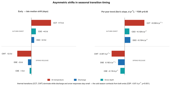
We studied 59 years of daily river flow, snow depth, and air temperature for a sub-Arctic river in Finland to see how the timing of seasonal change has shifted. Spring events now arrive earlier and together, while autumn events stay irregular and lag behind. The cold season is shrinking from both ends, and the atmosphere is increasingly running ahead of the snow and water response. The amounts of water and snow, however, have not changed, only their timing.
Aimad El Issaoui, Veikka Taka, Harri Kaartinen, Antero Kukko, and Juha Hyyppä
Int. Arch. Photogramm. Remote Sens. Spatial Inf. Sci., XLIX-B2-2026, 169–174, https://doi.org/10.5194/isprs-archives-XLIX-B2-2026-169-2026, https://doi.org/10.5194/isprs-archives-XLIX-B2-2026-169-2026, 2026
Susanna Hyyppä, Josef Taher, Matti Hyyppä, Leena Matikainen, Xiaowei Yu, Harri Kaartinen, Oskari Saarinen, Kirsi Karila, Ville Luoma, Marjut Turtiainen, Birgitta Partanen, Roope Näsi, Jyri Maanpää, Eetu Puttonen, Arttu Kivimäki, Mikko Vastaranta, Antero Kukko, Hannu Hyyppä, Matti Vaaja, Fabio Remondino, Narges Takhtkeshha, and Juha Hyyppä
Int. Arch. Photogramm. Remote Sens. Spatial Inf. Sci., XLIX-B1-2026, 443–448, https://doi.org/10.5194/isprs-archives-XLIX-B1-2026-443-2026, https://doi.org/10.5194/isprs-archives-XLIX-B1-2026-443-2026, 2026
Heikki Hyyti, Matias Mäki-Leppilampi, and Harri Kaartinen
Int. Arch. Photogramm. Remote Sens. Spatial Inf. Sci., XLIX-B1-2026, 255–261, https://doi.org/10.5194/isprs-archives-XLIX-B1-2026-255-2026, https://doi.org/10.5194/isprs-archives-XLIX-B1-2026-255-2026, 2026
Zuoya Liu, Harri Kaartinen, Antero Kukko, Juha Hyyppa, and Ruizhi Chen
ISPRS Ann. Photogramm. Remote Sens. Spatial Inf. Sci., XI-1-2026, 297–302, https://doi.org/10.5194/isprs-annals-XI-1-2026-297-2026, https://doi.org/10.5194/isprs-annals-XI-1-2026-297-2026, 2026
Marie Korppoo, Inese Huttunen, Markus Huttunen, Maiju Narikka, Jari Silander, Tom Jilbert, Martin Forsius, Pirkko Kortelainen, Niina Kotamäki, Cintia Uvo, and Anna-Kaisa Ronkanen
Hydrol. Earth Syst. Sci., 30, 3095–3119, https://doi.org/10.5194/hess-30-3095-2026, https://doi.org/10.5194/hess-30-3095-2026, 2026
Short summary
Short summary
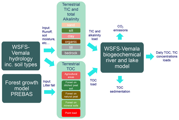
The development of carbon processes in the water quality model WSFS (Watershed Simulation and Forecasting System)-Vemala presents a significant advancement in simulating both total organic and inorganic carbon dynamics, burial and emissions through a river/lake network. The addition of organic acids to the total alkalinity definition improved pH simulations and thus the simulation of CO2 emissions in the acidic and organic rich waters of Finland. The new Vemala model provides a robust foundation to support water management in the future.
Petra Korhonen, Pertti Ala-Aho, Bjørn Kløve, and Hannu Marttila
Hydrol. Earth Syst. Sci., 30, 3019–3040, https://doi.org/10.5194/hess-30-3019-2026, https://doi.org/10.5194/hess-30-3019-2026, 2026
Short summary
Short summary
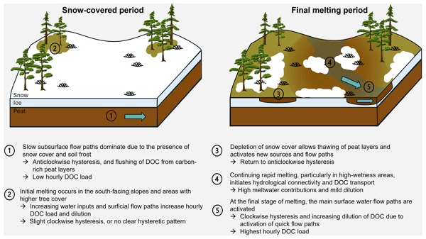
We studied how the melting of snow affects the release of dissolved organic carbon (DOC) in a northern peatland. Using detailed aerial surveys of snow cover, landscape moisture, and continuous water quality measurements revealed that DOC is released as snow cover melts, especially in wetter areas. Our results show how the snowmelt patterns control DOC transport, highlighting the sensitivity of northern peatland ecosystems to climate-driven changes in snow cover.
Guangxin He, Wang Zhang, Xiaoran Zhuang, Yuxuan Feng, Juanzhen Sun, Yubao Qiu, Lei Lei, and Jingjia Luo
EGUsphere, https://doi.org/10.5194/egusphere-2025-6488, https://doi.org/10.5194/egusphere-2025-6488, 2026
This preprint is open for discussion and under review for Atmospheric Measurement Techniques (AMT).
Short summary
Short summary
Accurate weather forecasting is vital for safety but faces challenges with calculation errors. We developed a new predictive model that enhances accuracy by reducing data redundancy and optimizing information flow. Experiments with real radar data show our approach significantly outperforms existing methods, particularly for heavy rainfall. This model maintains clear details over time, offering a robust tool for timely severe weather warnings and effective disaster prevention.
Zhengxin Jiang, Yubao Qiu, Matti Leppäranta, Xiaoting Li, Peng Yao, Guoqiang Jia, and Jiancheng Shi
Earth Syst. Sci. Data Discuss., https://doi.org/10.5194/essd-2025-721, https://doi.org/10.5194/essd-2025-721, 2026
Preprint under review for ESSD
Short summary
Short summary
Lake ice profoundly impacts regional climate and ecosystems in cold climate regions. The long-term daily lake ice coverage, annual ice phenology, and the probability of complete ice-cover occurrence were produced for 32800 global lakes using gap-filled MODIS data from 2002 to 2024. Patterns and trends of ice phenology and ice-cover status quantitatively revealed that how lakes respond to the climate change. The dataset provides a valuable resource for hydrology, ecology and climate research.
Andreas Güntner, Ehsan Sharifi, Julian Haas, Eva Boergens, Feifei Cao, Christoph Dahle, Neda Darbeheshti, Henryk Dobslaw, Inés Dussaillant, Wouter Dorigo, Frank Flechtner, Adrian Jäggi, Miriam Kosmale, Martin Lasser, Kari Luojus, Ulrich Meyer, Adam Pasik, Wolfgang Preimersberger, Claudia Ruz Vargas, and Michael Zemp
Earth Syst. Sci. Data Discuss., https://doi.org/10.5194/essd-2025-797, https://doi.org/10.5194/essd-2025-797, 2026
Revised manuscript accepted for ESSD
Short summary
Short summary
We provide a data set that illustrates how the amount of water that is stored in the subsurface as groundwater varies in time over the continents of the Earth. A main source of the data are observations with satellites that weigh the changing amount of water by its mass attraction effect. The data allow for assessing how groundwater as the most important freshwater resource for mankind and ecosystems is affected by climate variability, climate change and withdrawal by human activities.
Pinja Venäläinen, Colleen Mortimer, Kari Luojus, Lawrence Mudryk, Matias Takala, and Jouni Pulliainen
The Cryosphere, 19, 6301–6318, https://doi.org/10.5194/tc-19-6301-2025, https://doi.org/10.5194/tc-19-6301-2025, 2025
Short summary
Short summary
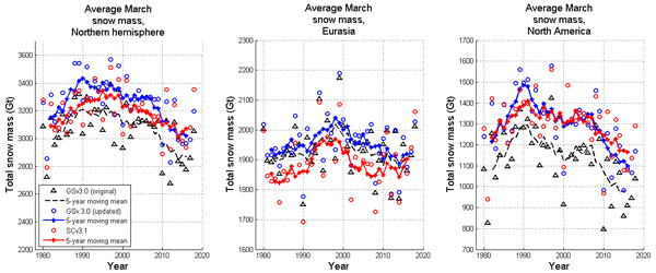
Satellite data-based estimation of large snow water equivalent (SWE) values can be improved with bias correction. This study updates the bias correction method by using updated snow course data, extending correction to two new months. Additionally, bias correction is expanded from a monthly to a daily time scale. The daily bias correction offers more accurate hemispheric snow mass estimation, aligning well with reanalysis data.
Joonas Kousa, Teemu Hakala, Antero Kukko, and Harri Kaartinen
ISPRS Ann. Photogramm. Remote Sens. Spatial Inf. Sci., X-2-W2-2025, 101–108, https://doi.org/10.5194/isprs-annals-X-2-W2-2025-101-2025, https://doi.org/10.5194/isprs-annals-X-2-W2-2025-101-2025, 2025
Evgeny Lopatin, Kari Väätäinen, Harri Kaartinen, Heikki Hyyti, Lauri Sikanen, Yrjö Nuutinen, and Mauricio Acuna
ISPRS Ann. Photogramm. Remote Sens. Spatial Inf. Sci., X-2-W2-2025, 117–123, https://doi.org/10.5194/isprs-annals-X-2-W2-2025-117-2025, https://doi.org/10.5194/isprs-annals-X-2-W2-2025-117-2025, 2025
Matias Mäki-Leppilampi, Heikki Hyyti, and Harri Kaartinen
ISPRS Ann. Photogramm. Remote Sens. Spatial Inf. Sci., X-2-W2-2025, 125–132, https://doi.org/10.5194/isprs-annals-X-2-W2-2025-125-2025, https://doi.org/10.5194/isprs-annals-X-2-W2-2025-125-2025, 2025
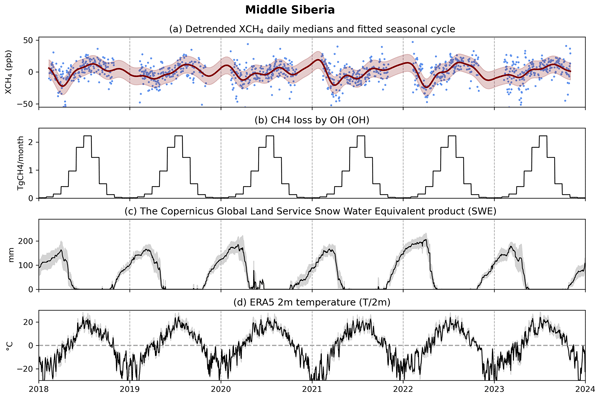
Ella Kivimäki, Maria Tenkanen, Tuula Aalto, Michael Buchwitz, Kari Luojus, Jouni Pulliainen, Kimmo Rautiainen, Oliver Schneising, Anu-Maija Sundström, Johanna Tamminen, Aki Tsuruta, and Hannakaisa Lindqvist
Biogeosciences, 22, 5193–5230, https://doi.org/10.5194/bg-22-5193-2025, https://doi.org/10.5194/bg-22-5193-2025, 2025
Short summary
Short summary
We study how environmental variables influencing natural methane fluxes explain the seasonal variability in satellite-observed methane in Northern Hemisphere high-latitude wetland areas. Using two atmospheric model set-ups, we assess consistency with satellite data. Methane loss through reaction with hydroxyl radicals and links with snow cover, temperature, and snowmelt had the strongest influence. Our study highlights the value of satellite observations for understanding large-scale wetland emissions.
Zuoya Liu, Harri Kaartinen, Teemu Hakala, Heikki Hyyti, Antero Kukko, Juha Hyyppa, and Ruizhi Chen
ISPRS Ann. Photogramm. Remote Sens. Spatial Inf. Sci., X-G-2025, 551–557, https://doi.org/10.5194/isprs-annals-X-G-2025-551-2025, https://doi.org/10.5194/isprs-annals-X-G-2025-551-2025, 2025
Tamás Faitli, Heikki Hyyti, Juha Hyyppä, Antero Kukko, and Harri Kaartinen
Int. Arch. Photogramm. Remote Sens. Spatial Inf. Sci., XLVIII-1-W4-2025, 37–42, https://doi.org/10.5194/isprs-archives-XLVIII-1-W4-2025-37-2025, https://doi.org/10.5194/isprs-archives-XLVIII-1-W4-2025-37-2025, 2025
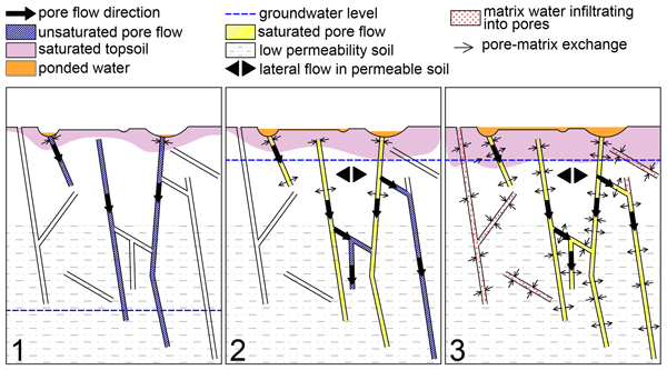
Filip Muhic, Pertti Ala-Aho, Matthias Sprenger, Björn Klöve, and Hannu Marttila
Hydrol. Earth Syst. Sci., 28, 4861–4881, https://doi.org/10.5194/hess-28-4861-2024, https://doi.org/10.5194/hess-28-4861-2024, 2024
Short summary
Short summary
The snowmelt event governs the hydrological cycle of sub-arctic areas. In this study, we conducted a tracer experiment on a forested hilltop in Lapland to identify how high-volume infiltration events modify the soil water storage. We found that a strong tracer signal remained in deeper soil layers after the experiment and over the winter, but it got fully displaced during the snowmelt. We propose a conceptual infiltration model that explains how the snowmelt homogenizes the soil water storage.
Umer Saleem, Ali Torabi Haghighi, Björn Klöve, and Mourad Oussalah
EGUsphere, https://doi.org/10.5194/egusphere-2024-1170, https://doi.org/10.5194/egusphere-2024-1170, 2024
This preprint is open for discussion and under review for Atmospheric Measurement Techniques (AMT).
Short summary
Short summary
This paper discusses the impact of citizen science and remote sensing on water quality monitoring. It explores applications combining citizen science with tools like microwave and optical systems, assessing parameters and techniques via apps such as EyeOnWater and HydroColor. It highlights the transformative potential in addressing water quality research gaps.
Getnet Demil, Ali Torabi Haghighi, Björn Klöve, and Mourad Oussalah
EGUsphere, https://doi.org/10.5194/egusphere-2024-1158, https://doi.org/10.5194/egusphere-2024-1158, 2024
This preprint is open for discussion and under review for Atmospheric Measurement Techniques (AMT).
Short summary
Short summary
This review explores using advanced image-based methods to estimate snow parameters for water resource management. Deep learning and satellite imagery improve accuracy in predicting snowmelt and depth. Challenges like data availability persist; addressing them requires novel deep learning architectures and better data synchronization. Integration of image-based approaches can revolutionize snow hydrology modeling and environmental management.
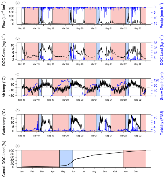
Danny Croghan, Pertti Ala-Aho, Jeffrey Welker, Kaisa-Riikka Mustonen, Kieran Khamis, David M. Hannah, Jussi Vuorenmaa, Bjørn Kløve, and Hannu Marttila
Hydrol. Earth Syst. Sci., 28, 1055–1070, https://doi.org/10.5194/hess-28-1055-2024, https://doi.org/10.5194/hess-28-1055-2024, 2024
Short summary
Short summary
The transport of dissolved organic carbon (DOC) from land into streams is changing due to climate change. We used a multi-year dataset of DOC and predictors of DOC in a subarctic stream to find out how transport of DOC varied between seasons and between years. We found that the way DOC is transported varied strongly seasonally, but year-to-year differences were less apparent. We conclude that the mechanisms of transport show a higher degree of interannual consistency than previously thought.
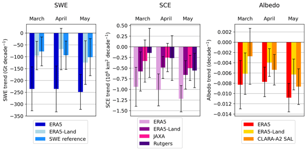
Kerttu Kouki, Kari Luojus, and Aku Riihelä
The Cryosphere, 17, 5007–5026, https://doi.org/10.5194/tc-17-5007-2023, https://doi.org/10.5194/tc-17-5007-2023, 2023
Short summary
Short summary
We evaluated snow cover properties in state-of-the-art reanalyses (ERA5 and ERA5-Land) with satellite-based datasets. Both ERA5 and ERA5-Land overestimate snow mass, whereas albedo estimates are more consistent between the datasets. Snow cover extent (SCE) is accurately described in ERA5-Land, while ERA5 shows larger SCE than the satellite-based datasets. The trends in snow mass, SCE, and albedo are mostly negative in 1982–2018, and the negative trends become more apparent when spring advances.
Anssi Rauhala, Leo-Juhani Meriö, Anton Kuzmin, Pasi Korpelainen, Pertti Ala-aho, Timo Kumpula, Bjørn Kløve, and Hannu Marttila
The Cryosphere, 17, 4343–4362, https://doi.org/10.5194/tc-17-4343-2023, https://doi.org/10.5194/tc-17-4343-2023, 2023
Short summary
Short summary
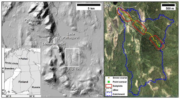
Snow conditions in the Northern Hemisphere are rapidly changing, and information on snow depth is important for decision-making. We present snow depth measurements using different drones throughout the winter at a subarctic site. Generally, all drones produced good estimates of snow depth in open areas. However, differences were observed in the accuracies produced by the different drones, and a reduction in accuracy was observed when moving from an open mire area to forest-covered areas.
Leo-Juhani Meriö, Anssi Rauhala, Pertti Ala-aho, Anton Kuzmin, Pasi Korpelainen, Timo Kumpula, Bjørn Kløve, and Hannu Marttila
The Cryosphere, 17, 4363–4380, https://doi.org/10.5194/tc-17-4363-2023, https://doi.org/10.5194/tc-17-4363-2023, 2023
Short summary
Short summary
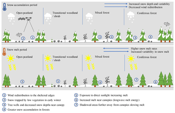
Information on seasonal snow cover is essential in understanding snow processes and operational forecasting. We study the spatiotemporal variability in snow depth and snow processes in a subarctic, boreal landscape using drones. We identified multiple theoretically known snow processes and interactions between snow and vegetation. The results highlight the applicability of the drones to be used for a detailed study of snow depth in multiple land cover types and snow–vegetation interactions.
T. Faitli, T. Hakala, H. Kaartinen, J. Hyyppä, and A. Kukko
Int. Arch. Photogramm. Remote Sens. Spatial Inf. Sci., XLVIII-1-W1-2023, 145–150, https://doi.org/10.5194/isprs-archives-XLVIII-1-W1-2023-145-2023, https://doi.org/10.5194/isprs-archives-XLVIII-1-W1-2023-145-2023, 2023
Pinja Venäläinen, Kari Luojus, Colleen Mortimer, Juha Lemmetyinen, Jouni Pulliainen, Matias Takala, Mikko Moisander, and Lina Zschenderlein
The Cryosphere, 17, 719–736, https://doi.org/10.5194/tc-17-719-2023, https://doi.org/10.5194/tc-17-719-2023, 2023
Short summary
Short summary
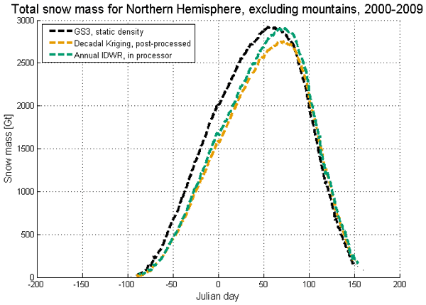
Snow water equivalent (SWE) is a valuable characteristic of snow cover. In this research, we improve the radiometer-based GlobSnow SWE retrieval methodology by implementing spatially and temporally varying snow densities into the retrieval procedure. In addition to improving the accuracy of SWE retrieval, varying snow densities were found to improve the magnitude and seasonal evolution of the Northern Hemisphere snow mass estimate compared to the baseline product.
P. Rönnholm, S. Wittke, M. Ingman, P. Putkiranta, H. Kauhanen, H. Kaartinen, and M. T. Vaaja
Int. Arch. Photogramm. Remote Sens. Spatial Inf. Sci., XLIII-B2-2022, 633–639, https://doi.org/10.5194/isprs-archives-XLIII-B2-2022-633-2022, https://doi.org/10.5194/isprs-archives-XLIII-B2-2022-633-2022, 2022
Kerttu Kouki, Petri Räisänen, Kari Luojus, Anna Luomaranta, and Aku Riihelä
The Cryosphere, 16, 1007–1030, https://doi.org/10.5194/tc-16-1007-2022, https://doi.org/10.5194/tc-16-1007-2022, 2022
Short summary
Short summary
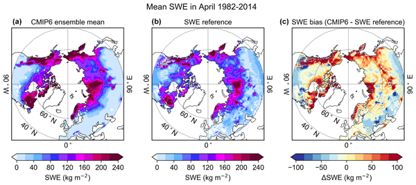
We analyze state-of-the-art climate models’ ability to describe snow mass and whether biases in modeled temperature or precipitation can explain the discrepancies in snow mass. In winter, biases in precipitation are the main factor affecting snow mass, while in spring, biases in temperature becomes more important, which is an expected result. However, temperature or precipitation cannot explain all snow mass discrepancies. Other factors, such as models’ structural errors, are also significant.
Cited articles
Allen, G. H. and Pavelsky, T. M.: Global extent of rivers and streams, Science, 361, 585–588, https://doi.org/10.1126/science.aat0636, 2018.
Beltaos, S.: Progress in the study and management of river ice jams, Cold Reg. Sci. Technol., 51, 2–19, https://doi.org/10.1016/j.coldregions.2007.09.001, 2008.
Beltaos, S. (Ed.).: River ice formation, Committee on River Ice Processes and the Environment, Canadian Geophysical Union Hydrology Section, Edmonton, ISBN 978-0-9920022-0-6, 2013.
Beltaos, S. and Prowse, T.: River-ice hydrology in a shrinking cryosphere, Hydrol. Process., 23, 122–144, https://doi.org/10.1002/hyp.7165, 2009.
Bennett, K. E. and Prowse, T. D.: Northern Hemisphere geography of ice-covered rivers, Hydrol. Process., 24, 235–240, https://doi.org/10.1002/hyp.7561, 2010.
Benson, B., Magnuson, J., and Sharma, S.: Global Lake and River Ice Phenology Database, Version 1, National Snow and Ice Data Center, Boulder, Colorado USA [data set], https://doi.org/10.7265/N5W66HP8, 2000.
Blackadar, R. J., Baxter, C. V., Davis, J. M., and Harris, H. E.: Effects of river ice break-up on organic-matter dynamics and feeding ecology of aquatic insects, River Res. Appl., 36, 480–491, https://doi.org/10.1002/rra.3585, 2020.
Blåfield, L., Marttila, H., Kasvi, E., and Alho, P.: Temporal shift of hydroclimatic regime and its influence on migration of a high latitude meandering river, J. Hydrol., 633, 130935, https://doi.org/10.1016/j.jhydrol.2024.130935, 2024.
Burrell, B. C., Comfort, G., and Beltaos, S.: Considerations in the planning and design of bridges in ice-affected rivers: a review, Can. J. Civil. Eng., 51, 109–124, https://doi.org/10.1139/cjce-2023-0039, 2023.
Chang, K. L., Schultz, M. G., Lan, X., McClure-Begley, A., Petropavlovskikh, I., Xu, X., and Ziemke, J. R.: Trend detection of atmospheric time series: Incorporating appropriate uncertainty estimates and handling extreme events, Elem. Sci. Anth., 9, 00035, https://doi.org/10.1525/elementa.2021.00035, 2021.
Chaouch, N., Temimi, M., Romanov, P., Cabrera, R., McKillop, G., and Khanbilvardi, R.: An automated algorithm for river ice monitoring over the Susquehanna River using the MODIS data, Hydrol. Process., 28, 62–73, https://doi.org/10.1002/hyp.9548, 2014.
Chen, Y. and She, Y.: Long-term variations of river ice breakup timing across Canada and its response to climate change, Cold Reg. Sci. Technol., 176, 103091, https://doi.org/10.1016/j.coldregions.2020.103091, 2020.
Chu, T. and Lindenschmidt, K. E.: Effects of river geomorphology on river ice freeze-up and break-up rates using MODIS imagery, Can. J. Remote Sens., 45, 176–191, https://doi.org/10.1080/07038992.2019.1635004, 2019.
Cooley, S. W. and Pavelsky, T. M.: Spatial and temporal patterns in Arctic river ice breakup revealed by automated ice detection from MODIS imagery, Remote Sens. Environ., 175, 310–322, https://doi.org/10.1016/j.rse.2016.01.004, 2016.
Crameri, F.: Scientific colour maps, Zenodo [code], https://doi.org/10.5281/zenodo.1243862, 2023.
de Rham, L., Dibike, Y., Beltaos, S., Peters, D., Bonsal, B., and Prowse, T.: A Canadian River Ice Database from the National Hydrometric Program Archives, Earth Syst. Sci. Data, 12, 1835–1860, https://doi.org/10.5194/essd-12-1835-2020, 2020.
de Rham, L. P., Prowse, T. D., and Bonsal, B. R.: Temporal variations in river-ice break-up over the Mackenzie River Basin, Canada, J. Hydrol., 349, 441–454, https://doi.org/10.1016/j.jhydrol.2007.11.018, 2008.
Dietz, A. J., Wohner, C., and Kuenzer, C.: European snow cover characteristics between 2000 and 2011 derived from improved MODIS daily snow cover products, Remote Sens.-Basel, 4, 2432–2454, https://doi.org/10.3390/rs4082432, 2012.
Feng, D., Gleason, C. J., Lin, P., Yang, X., Pan, M., and Ishitsuka, Y.: Recent changes to Arctic river discharge, Nat. Commun., 12, 6917, https://doi.org/10.1038/s41467-021-27228-1, 2021.
Frey, K. E. and McClelland, J. W.: Impacts of permafrost degradation on arctic river biogeochemistry, Hydrol. Process., 23, 169–182, https://doi.org/10.1002/hyp.7196, 2009.
Fukś, M.: Changes in river ice cover in the context of climate change and dam impacts: a review, Aquat. Sci., 85, 113, https://doi.org/10.1007/s00027-023-01011-4, 2023.
Gebre, S., Alfredsen, K., Lia, L., Stickler, M., and Tesaker, E.: Review of ice effects on hydropower systems, J. Cold Reg. Eng., 27, 196–222, https://doi.org/10.1061/(ASCE)CR.1943-5495.0000059, 2013.
Hall, D. K., Riggs, G. A., Salomonson, V. V., DiGirolamo, N. E., and Bayr, K. J.: MODIS snow-cover products, Remote Sens. Environ., 83, 181–194, https://doi.org/10.1016/S0034-4257(02)00095-0, 2002.
Holmes, R. M., Coe, M. T., Fiske, G. J., Gurtovaya, T., McClelland, J. W., Shiklomanov, A. I., Spencer, R. G., Tank, S. E., and Zhulidov, A. V.: Climate change impacts on the hydrology and biogeochemistry of Arctic rivers, Clim. Change Glob. Warm. Inland Wat., 1–26, https://doi.org/10.1002/9781118470596.ch1, 2013.
Holmes, R. M., Shiklomanov, A. I., Suslova, A., Tretiakov, M., McClelland, J. W., Scott, L., Spencer, R. G. M., and Tank, S. E.: River Discharge, Arctic Report Card 2021, 78, https://doi.org/10.25923/zevf-ar65, 2021.
Huang, F. and Shen, H. T.: Dam removal effect on the lower St. Regis River ice-jam floods, Can. J. Civil. Eng., 51, 215–227, https://doi.org/10.1139/cjce-2023-0040, 2023.
Jeffries, M. O., Morris, K., and Kozlenko, N.: Ice characteristics and processes, and remote sensing of frozen rivers and lakes, in: Remote Sensing in Northern Hydrology: Measuring Environmental Change, 63–90, https://doi.org/10.1029/163GM05, 2005.
Jeffries, M. O., Morris, K., and Duguay, C. R.: State of the earth's cryosphere at the beginning of the 21st century: glaciers, global snow cover, floating ice, and permafrost and periglacial environments – floating ice: lake ice and river ice, in: Satellite Image Atlas of Glaciers of the World, edited by: Williams, R. S. and Ferrigno, J. G., USGS, Reston, VA, A381–A424, https://doi.org/10.3133/pp1386A, 2012.
Kim, Y., Kimball, J. S., Glassy, J., and Du, J.: An extended global Earth system data record on daily landscape freeze–thaw status determined from satellite passive microwave remote sensing, Earth Syst. Sci. Data, 9, 133–147, https://doi.org/10.5194/essd-9-133-2017, 2017.
Lehner, B. and Grill, G.: Global river hydrography and network routing: baseline data and new approaches to study the world's large river systems, Hydrol. Process., 27, 2171–2186, https://doi.org/10.1002/hyp.9740, 2013.
Li, H., Li, H., Wang, J., and Hao, X.: Revealing the river ice phenology on the Tibetan Plateau using Sentinel-2 and Landsat 8 overlapping orbit imagery, J. Hydrol., 619, 129285, https://doi.org/10.1016/j.jhydrol.2023.129285, 2023.
Li, X., Jing, Y., Shen, H., and Zhang, L.: The recent developments in cloud removal approaches of MODIS snow cover product, Hydrol. Earth Syst. Sci., 23, 2401–2416, https://doi.org/10.5194/hess-23-2401-2019, 2019.
Lisina, A. A., Krylenko, I. N., Kalugin, A. S., Motovilov, Y. G., Sazonov, A. A., and Frolova, N. L.: Assessment of the Kolyma Runoff under current climate changes, Water Resour., 50, S318-S322, https://doi.org/10.1134/S0097807823700513, 2023.
Liston, G. E. and Hiemstra, C. A.: The changing cryosphere: Pan-Arctic snow trends (1979–2009), J. Climate, 24, 5691–5712, https://doi.org/10.1175/JCLI-D-11-00081.1, 2011.
Liu, S., Wang, P., Huang, Q., Yu, J., Pozdniakov, S. P., and Kazak, E. S.: Seasonal and spatial variations in riverine DOC exports in permafrost-dominated Arctic river basins, J. Hydrol., 612, 128060, https://doi.org/10.1016/j.jhydrol.2022.128060, 2022.
Magnuson, J. J., Robertson, D. M., Benson, B. J., Wynne, R. H., Livingstone, D. M., Arai, T., Assel, R. A., Barry, R. G., Card, V., Kuusisto, E., and Granin, N. G.: Historical trends in lake and river ice cover in the Northern Hemisphere, Science, 289, 1743–1746, https://doi.org/10.1126/science.289.5485.1743, 2000.
Muñoz-Sabater, J., Dutra, E., Agustí-Panareda, A., Albergel, C., Arduini, G., Balsamo, G., Boussetta, S., Choulga, M., Harrigan, S., Hersbach, H., Martens, B., Miralles, D. G., Piles, M., Rodríguez-Fernández, N. J., Zsoter, E., Buontempo, C., and Thépaut, J.-N.: ERA5-Land: a state-of-the-art global reanalysis dataset for land applications, Earth Syst. Sci. Data, 13, 4349–4383, https://doi.org/10.5194/essd-13-4349-2021, 2021.
Newton, A. M. W. and Mullan, D. J.: Climate change and Northern Hemisphere lake and river ice phenology from 1931–2005, The Cryosphere, 15, 2211–2234, https://doi.org/10.5194/tc-15-2211-2021, 2021.
Osadchiev, A., Sedakov, R., Frey, D., Gordey, A., Rogozhin, V., Zabudkina, Z., Spivak, E., Kuskova, E., Sazhin, A., and Semiletov, I.: Intense zonal freshwater transport in the Eurasian Arctic during ice-covered season revealed by in situ measurements, Sci. Rep.-UK, 13, 16508, https://doi.org/10.1038/s41598-023-43524-w, 2023.
Patro, E. R., Ghadimi, S., Shahrood, A. J., Fazel, N., Makarieva, O., and Haghighi, A. T.: Flow regime alteration in Arctic rivers due to dam operations and climate change, Global Planet. Change, 237, 104442, https://doi.org/10.1016/j.gloplacha.2024.104442, 2024.
Pavelsky, T. M. and Smith, L. C.: Spatial and temporal patterns in Arctic river ice breakup observed with MODIS and AVHRR time series, Remote Sens. Environ., 93, 328–338, https://doi.org/10.1016/j.rse.2004.07.018, 2004.
Pithan, F. and Mauritsen, T.: Arctic amplification dominated by temperature feedbacks in contemporary climate models, Nat. Geosci., 7, 181–184, https://doi.org/10.1038/ngeo2071, 2014.
Podkowa, A., Kugler, Z., Nghiem, S. V., and Brakenridge, G. R.: Ice Freeze-Up and Break-Up in Arctic Rivers Observed With Satellite L-Band Passive Microwave Data From 2010 to 2020, Water Resour. Res., 59, e2022WR031939, https://doi.org/10.1029/2022WR031939, 2023.
Prowse, T., Alfredsen, K., Beltaos, S., Bonsal, B., Duguay, C., Korhola, A., McNamara, J., Pienitz, R., Vincent, W. F., Vuglinsky, V., and Weyhenmeyer, G. A.: Past and future changes in Arctic lake and river ice, Ambio, 40, 53–62, https://doi.org/10.1007/s13280-011-0216-7, 2011.
Prowse, T. D.: River-ice ecology. I: Hydrologic, geomorphic, and water-quality aspects, J. Cold Reg. Eng., 15, 1–16, https://doi.org/10.1061/(ASCE)0887-381X(2001)15:1(1), 2001.
Prowse, T. D., Bonsal, B. R., Duguay, C. R., and Lacroix, M. P.: River-ice break-up/freeze-up: a review of climatic drivers, historical trends and future predictions, Ann. Glaciol., 46, 443–451, https://doi.org/10.3189/172756407782871431, 2007.
Qiu, J.: CrisQiu/ESSD_2025: Code for “A Harmonized 2000–2024 Dataset of Daily River Ice Concentration and Annual Phenology for Major Arctic Rivers”, v1.0.0, Zenodo [code], https://doi.org/10.5281/zenodo.19627384, 2026.
Qiu, J., Luojus, K., Kaartinen, H., Qiu, Y., Silander, J., Patro, E. R., Klöve, B., and Haghighi, A. T.: A Harmonized 2000–2024 Dataset of Daily River Ice Concentration and Annual Phenology for Major Arctic Rivers, Zenodo [data set], https://doi.org/10.5281/zenodo.17054619, 2025a.
Qiu, J., Ran, J., Tangdamrongsub, N., Fettweis, X., Ali, S., Feng, W., and Wan, X.: Recent significant subseasonal fluctuations of supraglacial lakes on Greenland monitored by passive optical satellites, Remote Sens. Environ., 328, 114896, https://doi.org/10.1016/j.rse.2025.114896, 2025b.
Qiu, Y., Xie, P., Leppäranta, M., Wang, X., Lemmetyinen, J., Lin, H., and Shi, L.: MODIS-based daily lake ice extent and coverage dataset for Tibetan Plateau, Big Earth Data, 3, 170–185, https://doi.org/10.1080/20964471.2019.1631729, 2019.
Richards, E., Stuefer, S., Rangel, R. C., Maio, C., Belz, N., and Daanen, R.: An evaluation of GPR monitoring methods on varying river ice conditions: A case study in Alaska, Cold Reg. Sci. Technol., 210, 103819, https://doi.org/10.1016/j.coldregions.2023.103819, 2023.
Riggs, G. A., Hall, D. K., and Román, M. O.: MODIS snow products collection 6 user guide, https://modis-snow-ice.gsfc.nasa.gov/uploads/C6_MODIS_Snow_User_Guide.pdf (last access: 15 April 2026), 2016.
Scaife, A. A. and Smith, D.: A signal-to-noise paradox in climate science, npj Clim. Atmos. Sci., 1, 28, https://doi.org/10.1038/s41612-018-0038-4, 2018.
Serreze, M. C. and Barry, R. G.: The Arctic climate system, Cambridge University Press, https://doi.org/10.1017/CBO9781139583817, 2014.
Shiklomanov, A. I.: Data of river ice timing and thickness for selected river gauges in Russian pan-Arctic over 1970–2012, Arctic Data Center, https://doi.org/10.18739/A22Z12Q02, 2016.
Shiklomanov, A. I. and Lammers, R. B.: River ice responses to a warming Arctic – recent evidence from Russian rivers, Environ. Res. Lett., 9, 035008, https://doi.org/10.1088/1748-9326/9/3/035008, 2014.
Shiklomanov, A. I., Lammers, R. B., and Vörösmarty, C. J.: Widespread decline in hydrological monitoring threatens pan-Arctic research, EOS T. Am. Geophys. Un., 83, 13–17, https://doi.org/10.1029/2002EO000007, 2002.
Sojka, M., Ptak, M., and Zhu, S.: Use of Landsat Satellite images in the Assessment of the variability in Ice Cover on Polish Lakes, Remote Sens.-Basel, 15, 3030, https://doi.org/10.3390/rs15123030, 2023.
Van der Sanden, J. J., Drouin, H., and Geldsetzer, T.: An automated procedure to map breaking river ice with C-band HH SAR data, Remote Sens. Environ., 252, 112119, https://doi.org/10.1016/j.rse.2020.112119, 2021.
Vermote, E. and Wolfe, R.: MODIS/Terra Surface Reflectance Daily L2G Global 1 km and 500 m SIN Grid V061; NASA EOSDIS Land Process, https://doi.org/10.5067/MODIS/MOD09GA.061, 2021.
Wang, X. and Feng, L.: Patterns and Trends in Northern Hemisphere River Ice Phenology from 2000 to 2021, Remote Sens. Environ., 313, 114346, https://doi.org/10.1016/j.rse.2024.114346, 2024.
Yang, X., Pavelsky, T. M., and Allen, G. H.: The past and future of global river ice, Nature, 577, 69–73, https://doi.org/10.1038/s41586-019-1848-1, 2020.
Yao, R., Wang, L., Huang, X., Sun, L., Chen, R., Wu, X., Zhang, W., and Niu, Z.: A robust method for filling the gaps in MODIS and VIIRS land surface temperature data, IEEE T. Geosci. Remote, 59, 10738–10752, https://doi.org/10.1109/TGRS.2021.3053284, 2021.
Zakharov, I., Puestow, T., Khan, A. A., Briggs, R., and Barrette, P.: Review of river ice observation and data analysis technologies, Hydrology, 11, 126, https://doi.org/10.3390/hydrology11080126, 2024.
Zhang, Y., Qiu, Y., Li, Y., Leppäranta, M., Jia, G., Jiang, Z., and Liang, W.: Spatial-temporal variation of river ice coverage in the Yenisei river from 2002 to 2021, J. Hydrol., 637, 131440, https://doi.org/10.1016/j.jhydrol.2024.131440, 2024.
Short summary
We developed a 24-year record revealing how river ice on the six largest Arctic rivers has changed under a warming climate. Using satellite images from the MODIS Terra and Aqua sensors, we monitored daily ice cover and seasonal freeze-up and breakup timing. On average, over 65 % of river segments show later freeze-up (~ 9 d), earlier breakup (~ 8 d), and shorter ice seasons (~ 14 d), revealing a clear signal of rapid warming across Arctic river systems.
We developed a 24-year record revealing how river ice on the six largest Arctic rivers has...


Altmetrics
Final-revised paper
Preprint