the Creative Commons Attribution 4.0 License.
the Creative Commons Attribution 4.0 License.
 | 19 Dec 2025
Peat-DBase v.1: a compiled database of global peat depth measurements
Jade Skye
Colin Goldblatt
Louis Saumier
Angela Gallego-Sala
Michelle Garneau
R. Scott Winton
Erick B. Bahati
Juan C. Benavides
Lee Fedorchuk
Gérard Imani
Carol Kagaba Kairumba
Frank Kansiime
Mariusz Lamentowicz
Michel Mbasi
Daria Wochal
Sambor Czerwiński
Jacek Landowski
Joanna Landowska
Vincent Maire
Minna M. Väliranta
Matthew Warren
Lydia E. S. Cole
Marissa A. Davies
Erik A. Lilleskov
Jingjing Sun
Yuwan Wang
Peatlands are globally important carbon stores that face increasing threats from human activities and climate change impacts. Comprehensive peatland data are essential for understanding ecosystem responses to these stressors and mapping their past and current characteristics. Current peatland datasets remain limited due to poor representation in global soil mapping initiatives and the absence of a recognized, coordinated central repository for peat depth data. Existing compilations often contain errors, duplicates, and outdated observations, requiring researchers to repeatedly gather and harmonize data on a study-by-study basis. To address these challenges, we present Peat-DBase version 1.0 – a harmonized, quality-controlled global compilation of basal peat depth measurements.
Version 1.0 of Peat-DBase comprises 204 902 peat depth measurements from 29 sources spanning 54.933° S to 82.217° N, with a significant proportion of measurements in Atlantic Canada and Scotland due to the inclusion of two particularly large datasets focused on those regions. We supplement the peat study measurements with 94 615 non-peat soil measurements to ensure comprehensive coverage consistent with the relatively low spatial coverage of peatlands globally. Despite the uneven distribution of peat depth measurements, Peat-DBase contains reasonable coverage of the major global peatland complexes in temperate and boreal North America and Europe, portions of Russia, the Amazon and Congo basins, and the Malay Archipelago, though gaps remain in the lower Amazon Basin, Eastern Indonesia, and Eastern Russia. From the current data, peat depths have a median value of 130 cm (IQR: 60–240), although this is influenced by a predominance of measurements in the North Atlantic regions. Peat-DBase's deepest measurement is 2223 cm.
While sampling biases and measurement uncertainties exist, Peat-DBase provides an essential foundation for global peatland research. Peat-DBase is under active development and future versions will incorporate additional datasets, information on current peatland status, and improved positional uncertainty quantification. Peat-DBase eliminates the need for overlapping data compilation efforts while identifying critical observational gaps for future research. Peat-DBase is available at https://doi.org/10.5281/zenodo.15530644 (Skye et al., 2025).
- Article
(4483 KB) - Full-text XML
- BibTeX
- EndNote


The works published in this journal are distributed under the Creative Commons Attribution 4.0 License. This license does not affect the Crown copyright work, which is re-usable under the Open Government Licence (OGL). The Creative Commons Attribution 4.0 License and the OGL are interoperable and do not conflict with, reduce or limit each other.
© Crown Copyright 2025
Peatlands are important carbon (C) stores, comprising roughly one-third of global soil C despite only covering about 3 % of Earth’s land surface (Joosten and Clarke, 2002; Jackson et al., 2017; Xu et al., 2018; Melton et al., 2022). They also contain about 10 % of the world’s fresh surface water and support unique biodiversity (Joosten and Clarke, 2002; Page and Baird, 2016). Their persistently saturated conditions inhibit decomposition, enabling peat accumulation over centuries to millennia (Koster and Favier, 2005; Page and Baird, 2016; Joosten and Clarke, 2002). However, these ecosystems are sensitive to anthropogenic activity and climate change impacts (Loisel et al., 2021). Drainage for agriculture, forestry, and other land uses can alter peatland soil structure and function, lower water tables, promote aerobic decomposition, and dramatically increase carbon emissions (Fluet-Chouinard et al., 2023; Page and Baird, 2016; Warren et al., 2017; Koster and Favier, 2005; Li et al., 2018). Climate change intensifies these threats through rising temperatures and altered hydrologic regimes, with extreme weather events often leading to increased wildfire risk (Canadell et al., 2021; Helbig et al., 2020).
Comprehensive peatland data – including extent (Xu et al., 2018; Melton et al., 2022; Gumbricht et al., 2017), carbon content (Gorham, 1991; Page et al., 2011), protection status (Austin et al., 2025), land-use, land cover, and degree of degradation (Fluet-Chouinard et al., 2023) – are urgently needed to understand ecosystem responses to current environmental and anthropogenic stressors and project future ecosystem dynamics. As peatlands are increasingly incorporated into land surface models (Chadburn et al., 2022; Bechtold et al., 2019b; Wu et al., 2016) for eventual integration into Earth system models, as well as data-driven mapping applications (e.g., Minasny et al., 2019; Melton et al., 2022), robust peatland datasets are essential for model initialization and evaluation. However, peatland data remain scarce due to under-representation in global soil mapping initiatives (Krankina et al., 2008; Minasny et al., 2019) and the characteristically wet, and often remote, locations of peatlands, which create challenging conditions for field data collection (Minasny et al., 2019; Rudiyanto et al., 2016). Peat depth mapping is particularly difficult as it requires labour-intensive field surveys or proximal remote sensing techniques (Minasny et al., 2019; Jowsey, 1966).
To address these needs, we present Peat-DBase version 1.0 – a harmonized, quality-controlled global compilation of basal peat depth measurements. The database also includes mineral soil core data (Batjes et al., 2020b) to provide comprehensive coverage of peat-free areas. The rest of our paper is structured as follows. First, in Sect. 2, we explain the intentions of Peat-DBase and why it is needed now to advance global peatland science. Next, in Sect. 3, we describe the present state of Peat-DBase, the protocols for the acquisition, formatting, and processing for the peat study data; mineral soil data is covered in Appendix A. Then, in Sect. 4, we provide an analysis and discussion of the resulting database, including its limitations and our future plans for Peat-DBase. Finally, in Sects. 5 and 6, we discuss the data availability and conclusions, respectively.
While Peat-DBase v1.0 focuses on peat depth, our vision is to establish it as a comprehensive global repository for peatland carbon information. Our intention is to complement similar community-led initiatives like the Soil Respiration Database (SRDB; Jian et al., 2021), World Soil Information Service (WoSIS; Batjes et al., 2020a), and the International Soil Radiocarbon Database (ISRaD Lawrence et al., 2020), but with a focus on peatlands and their carbon stocks. Current peatland compilations assembled for individual studies (e.g. Gorham et al., 2012; Treat et al., 2019; Hugelius et al., 2020) can contain errors, duplicates, outdated observations (whereby a peatland has experienced natural or anthropogenic disturbance since measurement), among other issues. By creating a curated, open-source database, we eliminate the need for researchers to repeatedly gather, clean and harmonize data independently. Peat-DBase also does not duplicate the work of other peatland databases, such as “The Global Peatland Database” (https://greifswaldmoor.de/global-peatland-database-en.html, last access: 25 June 2025), which focuses on peatland extent and drainage status rather than depth measurements and does not permit access to the datasets behind the released map products; or “PeatData Hub” (https://peatdatahub.net/data-packages/, last access: 25 June 2025; Xu et al., 2018), which is also focused on peatland extent and water table depths.
Peat-DBase is particularly timely for several reasons. First, advancing peatland representation in land surface models (Wu et al., 2016; Bechtold et al., 2019a; Apers et al., 2022) requires accurate, extensive data for initialization and evaluation, especially as these models are integrated into Earth system models. Second, the proliferation of artificial intelligence (AI) techniques in geosciences (Wadoux et al., 2020) has enabled data-driven mapping of peatland extent (e.g., Minasny et al., 2019; Melton et al., 2022), carbon stocks (Hugelius et al., 2020; Widyastuti et al., 2025), and depth (Skye, 2025; Widyastuti et al., 2025). However, AI model outputs depend critically on training data quality and quantity (Aroyo et al., 2022; Roscher et al., 2024). Since these approaches cannot reliably extrapolate beyond their training domains (Xu et al., 2020; Hateffard et al., 2024), providing spatially extensive, high-quality datasets is essential. Third, despite facing intense pressures from human activities and climate change, peatlands remain poorly mapped, hindering conservation and restoration efforts (Austin et al., 2025). Fourth, as part of the Paris Agreement, 20 countries have already listed peatland or wetland soil organic carbon mitigation targets in their Nationally Determined Contributions (NDCs) (Wiese et al., 2021). However, many other countries did not include peatland or wetland soils in their NDCs, citing, among other reasons, the difficulty in accurately quantifying and monitoring change in these stocks (Wiese et al., 2021). Finally, global databases like Peat-DBase can identify critical observational gaps, motivating targeted research and data collection efforts.
The workflow to compile and process new peat depth datasets is shown in Fig. 1. The individual steps will be described in the following sections.
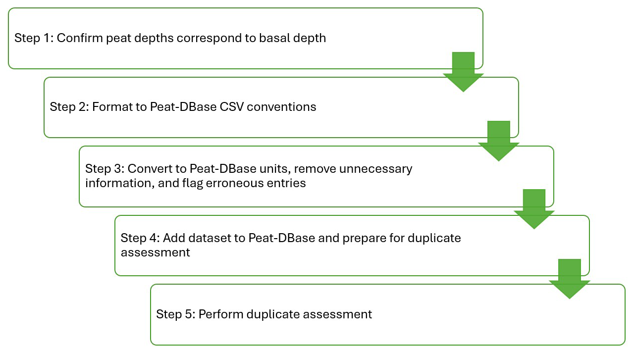
Figure 1Workflow to ingest peat-focused datasets into Peat-DBase. Future versions of Peat-DBase will allow peat data that does not reach the basal depth through the use of appropriate flags indicating that fact.
3.1 Data Acquisition
Peat study data were accepted into Peat-DBase provided the measurements were taken down to the basal depth indicated by mineral soil, lake sediments (gyttja), or bedrock1. Any coring or sampling method was allowed that could accurately determine this basal depth. To select studies we relied on the authors' identification of what constitutes peatlands or peat soils and their determination of the basal peat depth. In permafrost regions In permafrost regions, Cold Regions Research and Engineering Laboratory corers (Brockett and Lawson, 1985) were often used. In non-permafrost sites, Russian-type corers (Jowsey, 1966), Box corers (Shotyk and Noernberg, 2020; Fenton, 1980), and Jeglum corers (Jeglum et al., 1991) were the primary tools. In cases where pole probing was conducted as part of a coring transect, the probing measurements were also included. Probing, involves the use of metal poles which are inserted into the peat until they meet a non-peat layer and cannot go any further (e.g. Oakfield probes; Magnan et al., 2024; Householder et al., 2012; Crezee et al., 2022). We note probing has higher uncertainty for estimating peat depths as there is no visual confirmation of the interface between the peat and the underlying substrate.
The sampling protocol varied depending on the goals of the researchers. In some cases, transects of varying lengths were chosen with measurements taken at consistent intervals across the transect (e.g. Crezee et al., 2022; Kelly et al., 2020; Winton et al., 2025). In other instances, unique core sites were chosen across single or multiple peatlands (e.g. Cole et al., 2015; Davies et al., 2023b, a; Silvestri et al., 2019a). Some peat study datasets also included some cores taken in peat-free soils as a result of their sampling procedures (e.g. Crezee et al., 2022; Keys and Henderson, 1987; Thibault, 1992). Other data sources were extensive compilations of numerous field campaigns with different goals and objectives yielding comparably dense measurement coverage (e.g. Keys and Henderson, 1987; Thibault, 1992; Scottish Government, 2025).
Peat depth data available from government or non-governmental agencies were the largest sources of data in terms of number of measurements. The two principal datasets were made available for download online (e.g. NatureScot, n=174 159; https://soils.environment.gov.scot/maps/point-data/peatland-action-peat-depth/, last access: 26 May 2025) or associated with publications where the data was available upon request (e.g. the Government of New Brunswick, n=20 505; Keys and Henderson, 1987; Thibault, 1992).
Generally, the largest peat depth datasets derived from the scientific literature were compilations of other datasets. Such compiled datasets were typically developed for modelling purposes (e.g. Hugelius et al., 2020; Treat et al., 2017, 2019). As these compiled datasets can often have convoluted histories – frequently incorporating other compilations – they were added to Peat-DBase under the single citation of the compiling authors. Additional fields were used to track any information the compiling authors provided regarding their data sources (see Sect. 3.2 and Table 2).
A total of 204 902 peat depth measurements came from 29 sources (all totals are after error/duplicate assessment and listed in Table 1). Of these, four sources are previously unpublished representing 2352 measurements. Some publications were excluded from Peat-DBase because their underlying data were not readily accessible, lacked usable data files, or we could not confirm from the publication that the measurements represented basal peat depth. All sources of peat depth measurements used in Peat-DBase are listed in Table 1.
Bauer et al. (2024)Beilman et al. (2009)Benfield et al. (2021)Cole et al. (2015)Comas et al. (2015)Crezee et al. (2022)Davies et al. (2021)Davies et al. (2023a)Davies et al. (2023b)Gorham et al. (2012)Hribljan et al. (2023)Hugelius et al. (2020)Kelly et al. (2020)Keys and Henderson (1987); Thibault (1992)Lawson et al. (2023)Lamentowicz (2005)Scottish Government (2025)Silvestri et al. (2019a, b)Treat et al. (2017, 2019)Sun et al. (2023)Warren et al. (2012)Winton et al. (2025)Table 1The sources of peat study measurements in Peat-DBase v.1. The final number indicates the number of measurements (n) retained after error/duplicate assessment (sample_duplication_flag values of 1–5; see Sect. 3.3 and Table 2). The percent column indicates what percent of the original number of cores was retained after error/duplicate assessment.
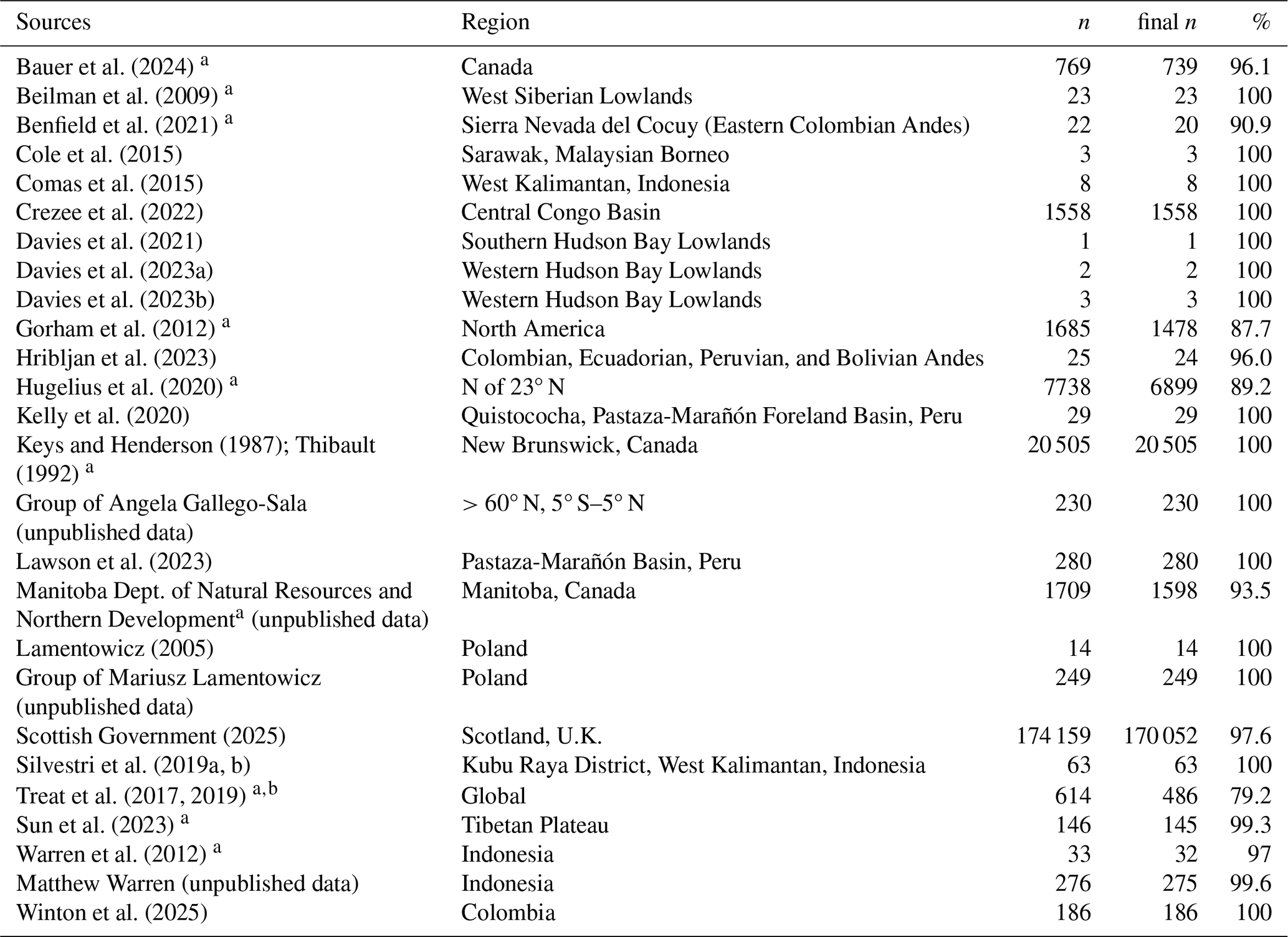
a indicates sources that are confirmed to be a compilation of other datasets.b Five of the cores in Treat et al. (2019) were excluded due to being located in the present-day ocean. These sites were not in error, but were collected to characterize peatlands across the last glacial cycle when the sites were subaerial.
3.2 Data Formatting
All collected data were processed into a consistent format. Source datasets were first converted to a CSV file format, if not already. Any measurements that were missing a latitude, longitude, or depth value were removed. All peat depth values were converted to centimetres and the coordinates of each measurement location were converted to the World Geodetic System 1984 (WGS84 or EPSG:4326) coordinate system, where required. When the depth measurement was presented as a range (this occurred in less than five measurements), the median of the values was determined and used within Peat-DBase. All datasets were then added to the Peat-DBase, which is structured as a single CSV file. The columns of this synthesized database are explained in Table 2.
Table 2The column headers within Peat-DBase and their meaning.
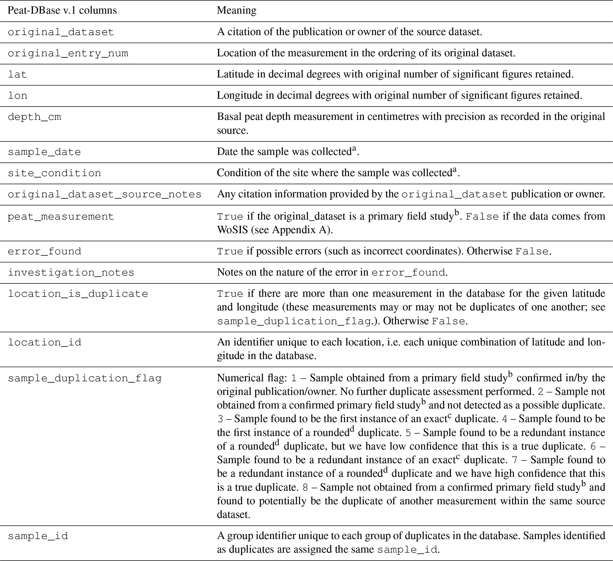
a Presently only available for the Scottish Government (2025) data. b Primary field study means the authors of the publication or dataset owners collected the data themselves. c Exact duplicate means that the lat, lon, and depth_cm values are identical. d Rounded duplicate means the lat and lon values are identical when rounded to 2 decimal places and the depth_cm values are within 0.5 cm.
3.3 Data Processing
Data entry errors require careful handling. As described in Sect. 3.2, incomplete measurements (e.g., missing latitude or longitude values) were excluded during initial data processing. However, some complete records contained obvious errors, such as peat measurements with coordinates placing them in the ocean. These clearly erroneous entries were flagged by setting the error_found column to True and documenting relevant details in the investigation_notes field (see Table 2).
Since Peat-DBase incorporates compiled datasets that are themselves compilations (see Table 1, e.g. Treat et al., 2017; Hugelius et al., 2020), additional quality control steps are necessary to handle duplicate entries. As Sarracino and Mikucka (2017) demonstrated, duplicates in modelling datasets can bias regression estimates, particularly when their distribution is non-random – a common occurrence when the same peat depth measurements appear across multiple compilations. To address this issue, we reassessed the database for duplicates each time a new source dataset was added. Rather than removing duplicates automatically, we flagged them to allow users to retain one measurement while filtering out redundant entries as needed (see Table 2 for columns used in duplicate assessment). This approach – retaining one instance while flagging others – was among the most effective strategies for reducing bias tested by Sarracino and Mikucka (2017), outperforming alternatives such as ignoring duplicates, removing all instances, or applying weighting schemes.
Duplicate flagging occurred in two phases. First, we identified exact duplicates – measurements with identical depth values and coordinates – and flagged all but the first instance with sample_duplication_flag values of 6 or 8 (depending on whether the duplication is occurring within the same source dataset or not, see Table 2) with the first instance given a value of 3. In the second phase, we deliberately reduced measurement precision to detect potential rounding by previous data sources. This process identified measurements with matching depth values when rounded to 0.5 cm and coordinates rounded to 0.01° , then flagged them for manual assessment. These precision thresholds were determined iteratively by testing progressively coarser rounding until the number of confirmed duplicates became minimal. We note that the rounded duplicates identification step was not applied within the Scottish Government (2025) dataset because of the high precision available for its sample coordinates.
For each potential duplicate, we examined the measurements and their citation information to determine whether they originated from a common study when possible. Measurements were flagged if they came from compiled datasets containing processed or rounded versions of data already present in Peat-DBase from their original sources. For example, both Sun et al. (2023) and Treat et al. (2017) incorporate data from Zhao et al. (2014), converting the original arc-minute coordinates to decimal degrees. Since Treat et al. (2017) retained fewer significant figures, their duplicate entries were flagged with values of 7 for the sample_duplication_flag. However, incomplete citation practices in some datasets prevented definitive conclusions. Measurements confirmed to originate directly from field studies were always retained, and we applied conservative criteria throughout – keeping measurements unless clear evidence of duplication existed (e.g. exact same coordinates with high precision and exact same depth). If we had low confidence in our assessment of a rounded duplicate, we applied a sample_duplication_flag value of 5 indicating the potential for the measurement to be a duplicate but also conveying the uncertainty in that assessment. Detected duplicates were sorted by precision and source. For rounded duplicates, the point with the greatest decimal precision was designated as the first instance. For exact duplicates, points were sorted alphabetically by dataset name (e.g., Gorham et al., 2012 before Hugelius et al., 2020). When datasets were added incrementally, previous duplicate assessments were retained, and newly added data were compared only against existing first instances and unduplicated records. Consequently, first instance designation reflects both the sorting criteria and the temporal sequence of data acquisition, which followed the order datasets were obtained (except datasets with publication restrictions, which were added last in their acquisition order).
As mentioned above, we retain all measurements in Peat-DBase, regardless of their sample_duplication_flag and error_found values. We do this to allow future refinement of these assessments, enhance traceability back to their original data sources, and to ensure our assessments can be audited as needed. When using Peat-DBase we suggest the following filtering then be applied: (1) select only error_found values of False, and (2) select sample_duplication_flag values of 1, 2, 3, 4, and 5. We note that some applications of Peat-DBase may require stringent removal of duplicates, in that case, sample_duplication_flag values of 5 should be removed as well.
4.1 General overview
Following harmonization and quality control procedures, Peat-DBase version 1.0 comprises 204 902 measurements from 29 peat-focused sources (Table 1). When combined with non-peat study data from WoSIS, the database contains 299 517 measurements (Fig. 2). The peat study data spans 54.933° S to 82.217° N, a latitudinal range that remains unchanged when incorporating non-peat study data.
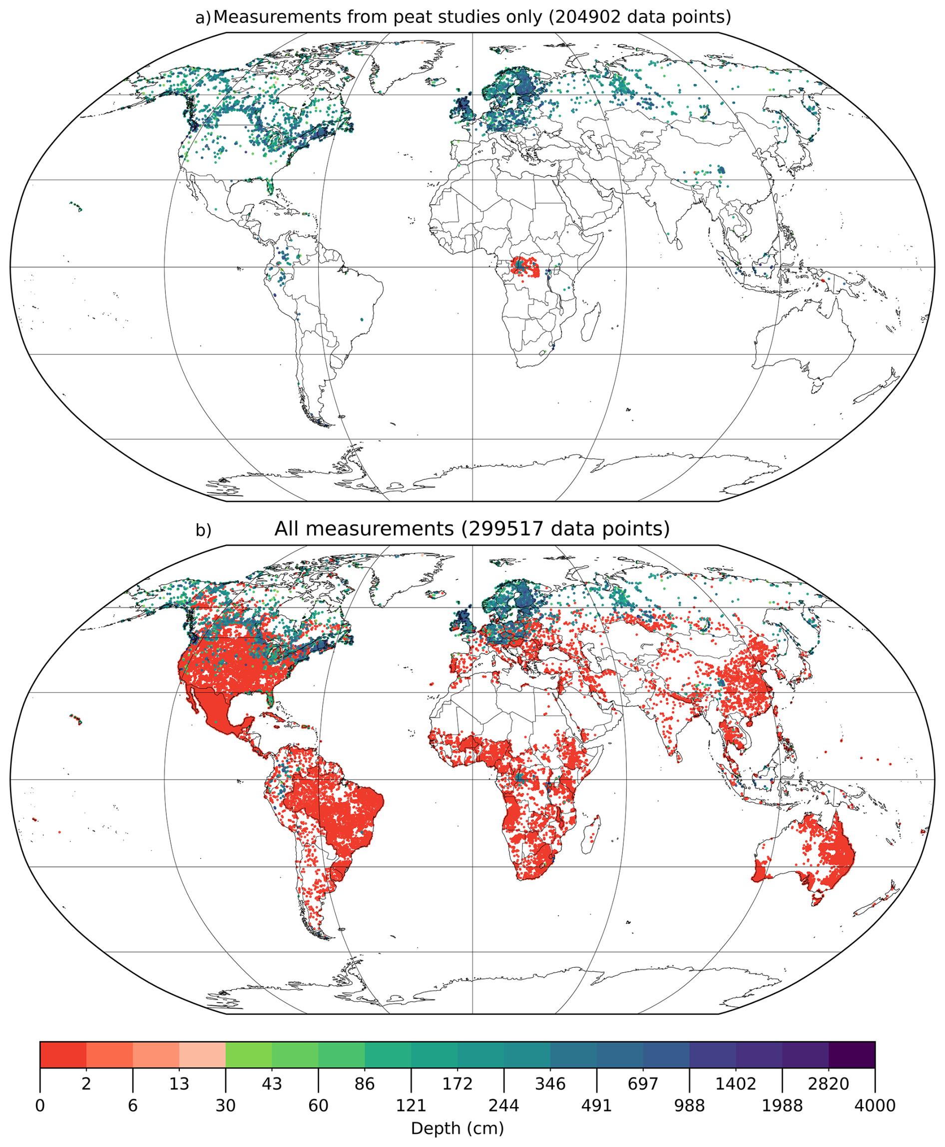
Figure 2Distribution of data points in Peat-DBase version 1.0. (a) Only the data points originating from peat-focused sources (primary field studies or compilations) without errors or duplicates, i.e. sample_duplication_flag values of 1–5; see Sect. 3.3 and Table 2, are shown. (b) As in subplot (a), but including those filtered from WoSIS. Note, the colour bar has a log scale with a colour break at 30 cm to visually delineate a common peat depth threshold for classification as a peatland (Loisel et al., 2017).
Figure 3 reveals that peat study data is heavily concentrated in the northern extratropics, with particularly high sample densities in New Brunswick, Canada and Scotland. This concentration reflects the inclusion of two large source datasets (Keys and Henderson, 1987; Thibault, 1992; Scottish Government, 2025). Users of Peat-DBase should be aware of this uneven spatial distribution, as it may introduce regional bias depending on the intended application. For global-scale analyses, sub-sampling these data-rich regions may be necessary to prevent New Brunswick and Scotland from exerting disproportionate influence on results.
Figure 2a shows that most peat depth measurements exceed 30 cm – a common threshold for peatland classification (Loisel et al., 2017). Among the peat-focused studies, 5831 measurements (2.8 %) report a zero cm peat depth, primarily from sampling schemes that measured across transects to assess peatland presence, such as those by Crezee et al. (2022) and Keys and Henderson (1987).
When incorporating filtered WoSIS data, zero-depth measurements increase to 100 446 (Fig. 2b). Figure 2b also highlights notable data gaps in desert regions like the Sahara and in certain countries such as Paraguay. These gaps exist in the original WoSIS database before any filtering described in Sect. A3 and are further discussed by Batjes et al. (2020b).
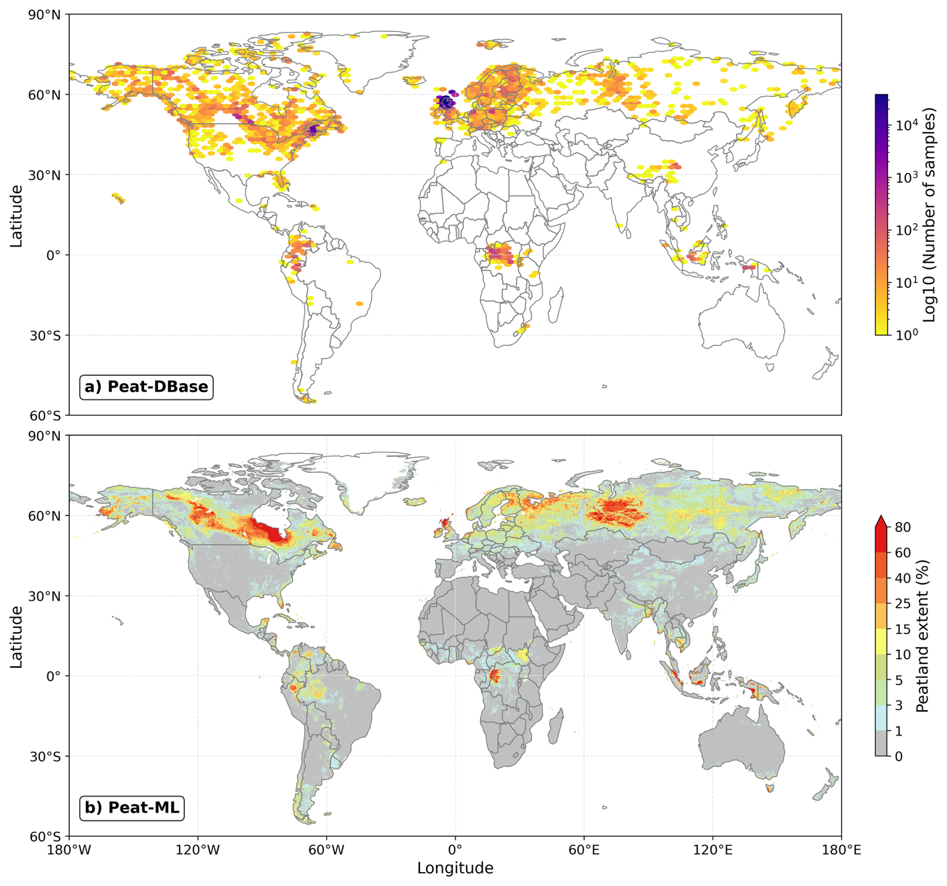
Figure 3(a) Map of Peat-DBase sample density for peat measurements as in Fig. 2a. Bin sizes are approximately 2.88° in longitude and 2.5° in latitude. Note the log scale. (b) Predicted peatland extent from Peat-ML (Melton et al., 2022).
4.2 Spatial and Depth Distribution of Data
Peat-DBase represents most major global peatland areas. The distribution of peat depth measurements (Figs. 2a and 3) broadly aligns with peatland fractional coverage shown in published global products: PEATMAP (Xu et al., 2018) and Peat-ML (Melton et al., 2022) and in the tropics-only CIFOR (Gumbricht et al., 2017). PEATMAP synthesizes the most detailed regional peatland maps available prior to 2018, while Peat-ML uses machine learning to predict global peatland coverage by training on regional peatland maps and environmental variables (Melton et al., 2022). Conversely, CIFOR is an expert-informed system predicting peatland area by integrating moisture supply, soil saturation, and geomorphological characteristics (Gumbricht et al., 2017).
Peat-DBase includes measurements from most major peatland complexes identified in both PEATMAP and Peat-ML, including those in North America, Eurasia, South America, the Congo Basin, and the Malay Archipelago (comparison against Peat-ML shown in Fig. 2). However, coverage gaps exist in the Amazon Basin, Indonesia, and Papua New Guinea, where PEATMAP and CIFOR indicate extensive peatland presence (Xu et al., 2018; Gumbricht et al., 2017). Peat-ML similarly shows greater peatland coverage in these regions and additionally in Eastern Russia. While paleoecological evidence supports substantial peatland presence in Eastern Russia (Yu et al., 2010, Fig. 1), we have not identified additional readily available peat depth datasets for this region. African peatlands are particularly poorly documented across the scientific literature (Gallego-Sala et al., 2025) and Peat-DBase also appears to also poorly represent the full extent of peatlands on the continent.
While Peat-DBase captures a significant proportion of our current knowledge on peat depth, it also reflects inherent biases arising from field research constraints. The database shows notably sparse coverage in low-latitude regions (Figs. 2, 3, 4), consistent with the historically less extensive mapping of tropical peatlands (Zinck, 2011; Ruwaimana et al., 2020). Although this tropical data gap shapes the current distribution within Peat-DBase, ongoing research efforts (e.g., Peat-ML2 – discussed in Sect. 4.3 and Winton et al., 2025) are attempting to address these knowledge gaps, and future studies will be incorporated into subsequent database versions as they become available.
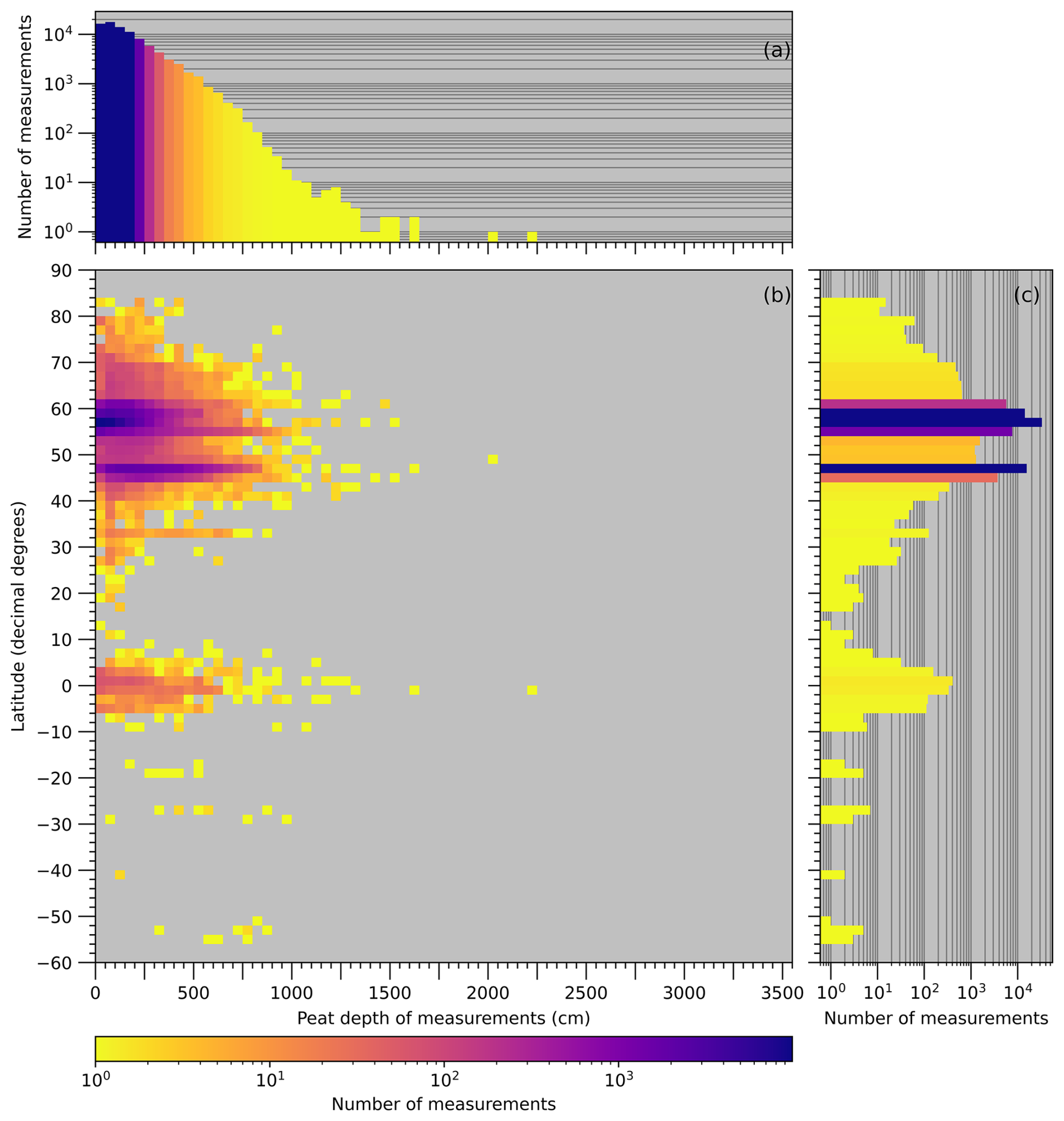
Figure 4Distribution of measurements by depth (a), by depth and latitude (b), and by latitude (c). WoSIS data are excluded from all panels. Additionally, for this plot, we removed data points noted as drained or modified. At present, this information is only available for the observations derived from the NatureScot dataset (Scottish Government, 2025). Data has been binned by 2° in latitude and 50 cm of depth.
The distribution of measurements in Peat-DBase reflect the prominence of peatlands in boreal, temperate, and tropical regions (Xu et al., 2018; Melton et al., 2022; Joosten and Clarke, 2002; Koster and Favier, 2005). Looking beyond the high sample densities in New Brunswick and Scotland, Figs. 4 and 3 shows peat measurements concentrated in high latitudes (particularly 40–50° N) and near the equator. Additional clusters appear at intermediate latitudes, such as around 35° N, corresponding to peatland complexes in Florida and the Tibetan Plateau (Fig. 2a). The deepest recorded measurement within Peat-DBase (2223 cm) occurs in Uganda in the East African Highlands (Treat et al., 2017).
The deepest peat deposits typically occur in regions that either escaped glaciation during the Last Glacial Maximum or were among the first to become ice-free during deglaciation, allowing extended accumulation periods (Treat et al., 2019; Ruwaimana et al., 2020; Gowan et al., 2021). Favourable topographic settings, such as flat floodplains and narrow river basins, also facilitate deep peat formation (Figs. 2, 4, and see Fig. 1 in Treat et al., 2019). However, peat depth does not correlate linearly with age, as peatlands undergo variable accumulation rates influenced by changing climatic and hydrologic conditions, including periods of enhanced growth, loss, stagnation, or erosion (Ruwaimana et al., 2020; Blaauw and Christen, 2005; van Bellen et al., 2011).
The depth distribution of non-zero measurements in Peat-DBase, which comprise 66.5 % of the database, can be fit with a Weibull Minimum distribution (red line in Fig. 5). When WoSIS data are excluded, the database composition shifts to non-zero peat depths constituting 97.2 % of measurements, with a median depth of 130 cm (interquartile range of 60–240 cm).
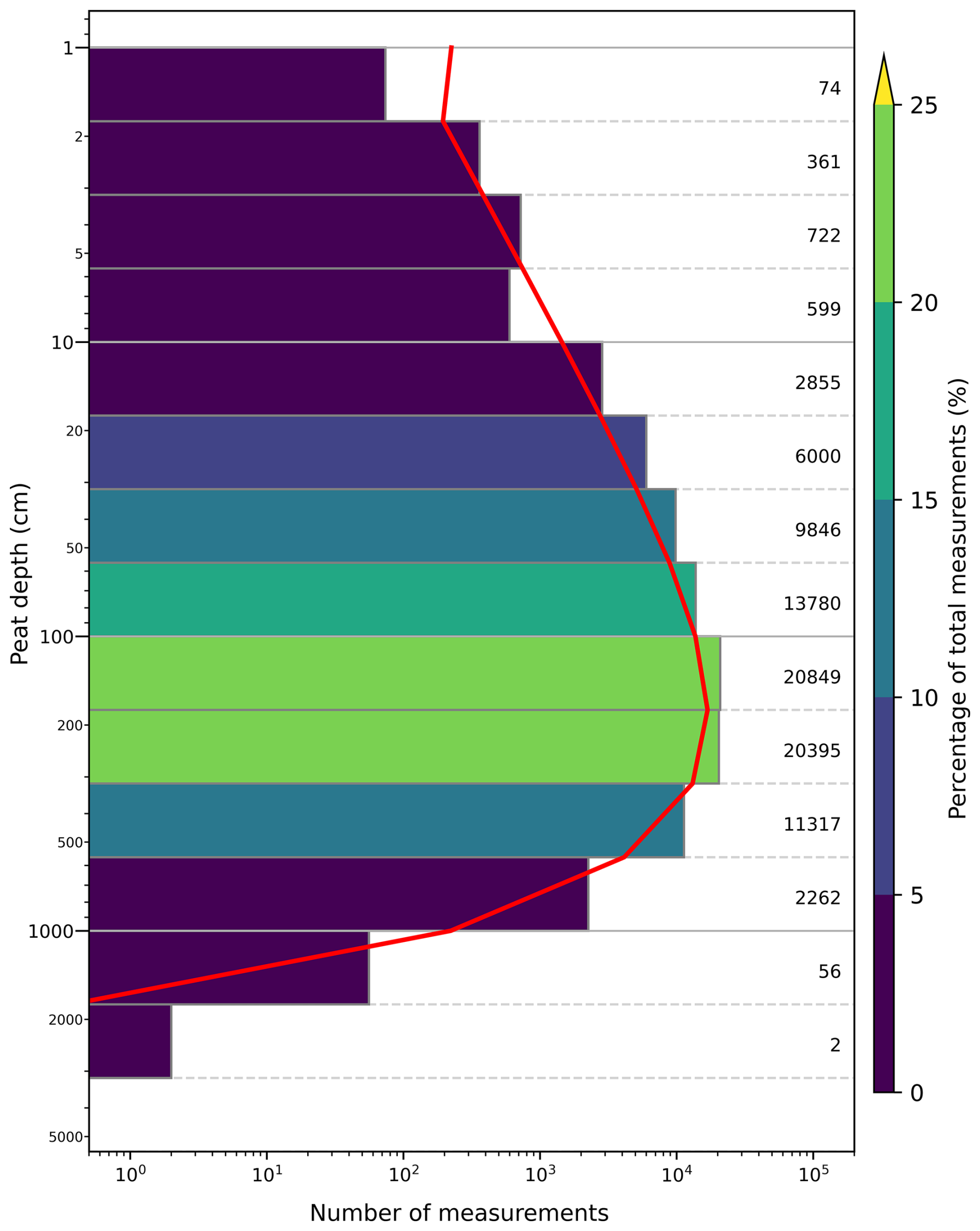
Figure 5Peat depth distribution within Peat-DBase version 1.0 on a log scale for all peat-present data points. The red line indicates the Weibull Minimum distribution (calculated via SciPy; Virtanen et al., 2020). Note the log scale is applied to both the x and y axes. As this plot focuses on depth distributions, we removed data points noted as drained or modified (n=110 924). At present, this information is only available for the observations derived from the NatureScot dataset (Scottish Government, 2025). Figure A1 is a version of this plot with those measurements included.
Most peatland field studies lack spatial scaling considerations, resulting in non-random, clustered distributions around research sites of interest (Hugelius et al., 2020; Meyer and Pebesma, 2022). This spatial clustering prevents direct comparisons between peat-to-non-peat ratios in Peat-DBase and actual peatland coverage.
Figure 5 reveals decreasing data availability with increasing peat depth. While this pattern may reflect natural peat development, sampling bias likely contributes. Deeper coring presents logistical challenges: standard equipment typically handles depths up to several hundred centimetres, while depths exceeding 1000 cm require specialized strategies and equipment (Bansal et al., 2023; Shotyk and Noernberg, 2020).
Our prioritization of large datasets for Peat-DBase version 1.0 may have excluded smaller studies or single-core investigations that reached substantial depths. Counterbalancing that bias, researchers often target presumed peatland centres – typically the deepest areas – for paleo-reconstructions, accumulation rate estimates, or carbon stock assessments. These studies frequently collect limited cores (Hugelius et al., 2013; Hribljan et al., 2016; Loisel et al., 2017), potentially skewing the database's depth distribution toward deeper measurements.
Limited core sampling can affect the representativeness of peat depth distributions in Peat-DBase. In peatlands developed over flat mineral basins with uniform surfaces, relatively few measurements may adequately capture depth variability. However, peatlands formed in complex topography or with variable surface gradients require more extensive sampling to accurately represent depth distributions (Hugelius et al., 2020; Loisel et al., 2017). van Bellen et al. (2011) illustrate this variability using probing, coring, and ground-penetrating radar to reveal surface altitude variations of two to eight metres within individual peatlands. Their findings show that maximum depths do not necessarily occur at geographic centres due to underlying basin topography. To address these sampling challenges, national or regional inventories, such as those from NatureScot (Scottish Government, 2025) and the Government of New Brunswick (Keys and Henderson, 1987; Thibault, 1992), and peatland mapping initiatives employ systematic transects and comprehensive sampling strategies designed to capture diverse peat formations (Hugelius et al., 2020; Crezee et al., 2022; Silvestri et al., 2019a; Parry et al., 2012). These broader sampling approaches can help mitigate depth representation bias within Peat-DBase.
4.3 Database Limitations and Future Work
Several uncertainties and limitations should be considered when using Peat-DBase. The database does not reflect current peatland status, as we included historical measurements regardless of present-day conditions. Consequently, some measurements may originate from peatlands that have since been degraded or destroyed by land-use change or climate impacts (Joosten and Clarke, 2002; Koster and Favier, 2005; Ratnayake, 2020; Silvestri et al., 2019a). Future versions will incorporate data on current peatland status to address this limitation. This enhancement is particularly important for applications utilizing Earth observation (EO) data, such as high-resolution land cover datasets, where temporal mismatches can create inconsistencies. Land surface changes occurring after peat core extraction – such as conversion to urban or industrial uses – can create conflicting information between recorded peat depths and current land use, potentially compromising data utility for contemporary analyses. Peat-DBase will also be expanded to include organic carbon content and bulk density data for the soil cores, as well as characteristic information about the sampling site such as hydrological status, soil water pH, vegetation present, etc.
The literature lacks consensus on peat definition, introducing classification uncertainties into Peat-DBase (Lourenco et al., 2022; Gumbricht et al., 2017; Page et al., 2011; Zinck, 2011; Magnan et al., 2024). Organic matter thresholds vary widely: Silvestri et al. (2019a) define peat as containing at least 30 % organic matter, while Cole et al. (2015) and Crezee et al. (2022) require at least 65 %. Currently, Peat-DBase does not track these varying definitional criteria; however, future versions will incorporate this information to ensure the influence of classification decisions on data interpretation remains traceable.
Measurement accuracy in Peat-DBase reflects the technological constraints of each study period. Many measurements from the 1950s through 1990s predate GPS technology or used early, less accurate receivers (Treat et al., 2017; Hugelius et al., 2020; Sun et al., 2023; Keys and Henderson, 1987). Historical data storage methods also pose challenges for the incorporation of known, existing data, with some datasets existing only in formats difficult to access or process (Thibault, 1992).
Field measurement techniques introduce additional uncertainties. Metal probes may encounter false resistance from buried wood fragments or interbedded mineral layers from ash (Hribljan et al., 2016), fluvium (Lähteenoja et al., 2012), or colluvium before reaching the true peat base (Parry et al., 2014). Coring can compress peat layers, leading to underestimated depths (Shotyk and Noernberg, 2020).
WoSIS shares similar sampling uncertainties with the peat study components of Peat-DBase. Batjes et al. (2020b) document variability in geographic coordinate precision and laboratory measurements within WoSIS, along with corresponding uncertainty metrics. However, since Peat-DBase focuses on peat presence rather than precise mineral soil characterization, we did not incorporate these WoSIS uncertainty measures when identifying non-peat locations. Nevertheless, variability in geographic coordinate precision affects Peat-DBase data from peat-focused sources and will be investigated in future versions to provide positional uncertainty estimates. These estimates are particularly important when using peat measurement data with high-resolution Earth observation (EO) data, as positional uncertainty can result in measurements being erroneously placed in oceans, on mountain tops, or other environments unsuitable for peat formation.
Our duplicate assessment (Sect. 3.3) may introduce subjective bias, as it relies on our interpretation of reasonable evidence of coordinate rounding. Furthermore, we did not test all possible decimal placements due to rounding, potentially missing both subtle and extreme rounding instances.
While some regions lack available peat depth data (Sect. 4.2), other areas have data not yet incorporated into Peat-DBase. Known examples include peat depth measurements from the Amazon Basin near the Madre de Dios River (Householder et al., 2012) and various Indonesian sites (Anda et al., 2021). These datasets were excluded because they lacked readily accessible point-based formats. Additionally, our prioritization of large datasets may have overlooked publications with single or few measurements. Future database versions will aim to incorporate these missing sources and additional datasets as they become available. For example, the Can-Peat project (https://uwaterloo.ca/can-peat/, last access: 25 June 2025) is currently developing a database of >100 000 Canadian peat depth measurements by digitizing and collating data from both published literature and mandated environmental impact assessments (April Dalton, personal communication, June 2025). We are aware of another large dataset (>18 000 measurements) focused on Alberta, Canada (Kelly Bona, personal communication, July 2025) that will also be incorporated as it becomes available.
Peat-DBase version 1.0 is stored in a CSV file located here https://doi.org/10.5281/zenodo.15530644 (Skye et al., 2025).
Peat-DBase is under active development under a Google grant, Peat-ML2: A new global benchmark for global peatland carbon inventories, awarded to JRM and RSW. We encourage interested data contributors to fill out a short survey found at https://forms.gle/WzbUpPQFZMK3Yyme6 (last access: 3 July 2025) to join the project or contact JRM, RSW, or LS.
Peat-DBase version 1.0 represents the most comprehensive global-scale compilation of peat depth data currently available. With over 200 000 measurements from peat-focused studies alone, it substantially expands when incorporating non-peat soil data. The database's spatial distribution largely aligns with established peatland coverage maps, though notable gaps remain in under-sampled regions. While sampling bias influences the depth distribution, the database serves dual purposes: providing essential data for global-scale analyses and highlighting geographic and depth-range gaps that warrant future research attention. Peat-DBase is presently under active development to both expand the number of measurements and improve its relevance and accuracy.
Non-peat study data were added to Peat-DBase to provide representation of non-peat regions. Given that non-peat areas were not the primary focus of Peat-DBase, detailed soil profiling was not prioritized. Rather, the goals in acquiring non-peat data were broad land coverage and confirmation of mineral soil presence. Measurements from these areas were assigned a peat depth of 0 cm.
A1 WoSIS
WoSIS maintains a harmonized and quality-controlled database of global soil profiles for digital soil mapping purposes. Existing soil data are submitted by owners for consideration in WoSIS, where they are stored, assessed, and standardized through the WoSIS workflow. Iterations of the fully quality-assessed and standardized database are released periodically as snapshots. The September 2019 snapshot was acquired for use in Peat-DBase. This snapshot is documented in Batjes et al. (2020b) and the data are available through Batjes et al. (2019).
A2 WoSIS Data Formatting
The non-peat study data were processed to the same format as the peat-focused study data. The WoSIS database is stored across several TSV files. Only the wosis_201909_profiles.tsv and wosis_201909_layers_chemical.tsv files were required for subsequent processing steps; these were converted to CSV file format. These files contain soil profile coordinates in WGS84 format and the chemical properties of soil profiles, respectively (Batjes et al., 2020b). This information was used to determine which cores represented mineral soil profiles and therefore non-peat cores.
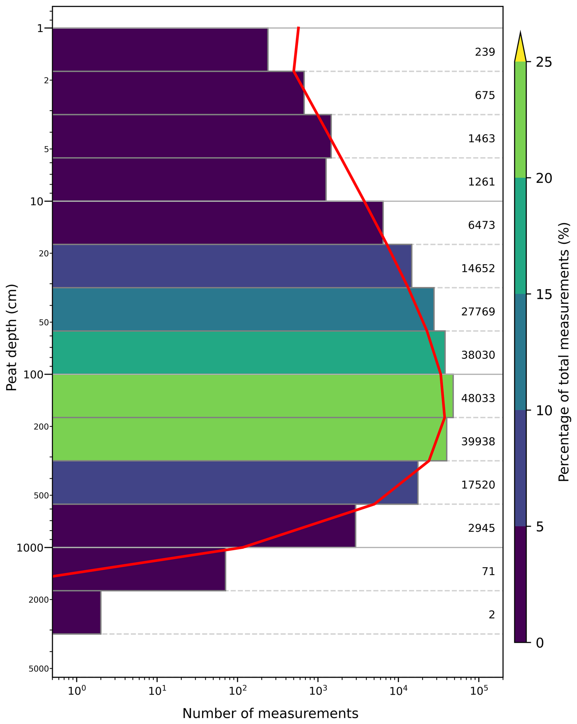
Figure A1Peat depth distribution within Peat-DBase version 1.0 on a log scale for samples with peat present. The red line indicates the Weibull Minimum distribution (calculated via SciPy; Virtanen et al., 2020). Note the log scale is applied to both the x and y axes. This plot includes data points noted as drained or modified in the NatureScot dataset (Scottish Government, 2025), which were excluded from Fig. 5.
A3 WoSIS Data Processing
The acquired soil profile data were filtered to include only mineral soil profiles. Our study broadly follows the peatland definition suggested by Lourenco et al. (2022), which specifies an area with a minimum of 5 % organic carbon content to a minimum depth of 10 cm. Here we treat soils with less than 5 % organic carbon content as mineral soils for the purpose of establishing peat-free locations. The WoSIS dataset often contains organic carbon content measurements in g/kg for multiple layers within a soil profile, although not all soil profiles have associated organic carbon content data (Batjes and Van Oostrum, 2023; Batjes et al., 2020b). Therefore, the first processing step was to exclude all soil profiles with no organic carbon content measurements, since their qualification as mineral soil based on our 5 % organic carbon threshold could not be readily determined otherwise. Next, all organic carbon content measurements were converted from gC kg−1 of soil mass to percent mass. Any profiles containing a layer with organic carbon content greater than or equal to 5 % were then excluded from the dataset. The coordinates of all remaining soil profiles were collected as a new dataset, and these locations were assigned a peat depth of 0 cm.
The data derived from WoSIS were not subject to duplicate assessment within this study. Duplicate assessment was deemed not necessary within the dataset itself, as assessment and exclusion processes were applied prior to the WoSIS snapshot release by the dataset authors (Batjes et al., 2020b). Regardless, we note there remains some entries from the WoSIS database within Peat-DBase that have the same location_id and with a depth_cm of 0. Users may need to filter those entries depending on their need as they may also be considered duplicates (e.g. when training machine-learning models). Duplicate assessment was additionally not conducted between the derived mineral soil cores and the peat study database, as we assumed significant duplication between mineral soil profiles and peat study data would be unlikely.
Conceptualization, Funding acquisition, and Project administration: JRM; Methodology: JS, JRM, CG, AG-S, RSW, MG, LS; Investigation and Data Curation: JS, LS; Formal analysis: JS, LS, JRM; Resources (unpublished data): AG-S, JCB, GI, EBB, CK, FK, MM, VM, MMV, ML, DW, SC, JaL, JoL, MW, LF; Resources: RSW, LS, ML, LESC, MAD, EAL, JS, YW, JRM, CG; Software: JS, LS; Validation: JS, LS, JRM; Visualization: JS, JRM; Writing – original draft: JS, JRM, CG; Writing – review & editing: All; Supervision: JRM, CG.
The contact author has declared that none of the authors has any competing interests.
Publisher’s note: Copernicus Publications remains neutral with regard to jurisdictional claims made in the text, published maps, institutional affiliations, or any other geographical representation in this paper. While Copernicus Publications makes every effort to include appropriate place names, the final responsibility lies with the authors. Views expressed in the text are those of the authors and do not necessarily reflect the views of the publisher.
We thank Emily Prystupa for supplying data on behalf of the Department of Natural Resources for the Government of New Brunswick; Kelly Bona and Kara Webster for helping with access to the Bauer et al. (2024) dataset; Esther Lévesque for her assistance collecting samples in Nunavut. For unpublished data contributed by the group of AG-S, we acknowledge the community of Mittimatalik (NU), the Centre d'études nordiques and Parks Canada (permit # SIR-2021-39579) for access to the site as well as the logistical support of the Polar Continental Shelf Program (Natural Resources Canada). AI chat engines were used to assist coding tasks relating to Peat-DBase visualization and copy editing of the manuscript text written by the authors.
JS was supported by the Federal Student Work Experience Program through Environment and Climate Change Canada, and a University of Victoria Faculty of Graduate Studies Fellowship. LS was supported by a Google grant, “Peat-ML2: A new global benchmark for global peatland carbon inventories”, awarded to JRM and RSW. AGS was funded by the European Research Council (ERC) under the European Union's Horizon 2020 research and innovation programme (grant agreement No. 865403) and by the UK Natural Environment Research Council under agreement number NE/S001166/1. ML, DW, JaL and JoL were funded by the National Science Centre, Poland, grant no. 2021/41/B/ST10/00060. The Polish fieldwork was done within the scope of the project “Protection of Valuable Ecosystems of Tuchola Forest” funded by the European Economic Area Financial Mechanism 2014–2021 within the framework of the Environment, Energy and Climate Change Programme MF EEA 2014–2021 “Implementation of Ecosystem Management Plans”. For unpublished data contributed by the group of AG-S, we acknowledge the financial support of the Natural Sciences and Engineering Research Council of Canada (Discovery program). YW acknowledges a PhD scholarship via the QUEX Institute (The University of Queensland and The University of Exeter). LC acknowledges NERC, the NERC Radiocarbon Dating Facility (Radiocarbon Analysis Allocation Number 1565.0411) and SUERC Dating Lab for their financial support.
This paper was edited by Giulio G. R. Iovine and reviewed by Steve Frolking and one anonymous referee.
Anda, M., Ritung, S., Suryani, E., Sukarman, Hikmat, M., Yatno, E., Mulyani, A., Subandiono, R. E., Suratman, and Husnain: Revisiting tropical peatlands in Indonesia: Semi-detailed mapping, extent and depth distribution assessment, Geoderma, 402, 115235, https://doi.org/10.1016/j.geoderma.2021.115235, 2021. a
Apers, S., De Lannoy, G. J. M., Baird, A. J., Cobb, A. R., Dargie, G. C., Del Aguila Pasquel, J., Gruber, A., Hastie, A., Hidayat, H., Hirano, T., Hoyt, A. M., Jovani-Sancho, A. J., Katimon, A., Kurnain, A., Koster, R. D., Lampela, M., Mahanama, S. P. P., Melling, L., Page, S. E., Reichle, R. H., Taufik, M., Vanderborght, J., and Bechtold, M.: Tropical peatland hydrology simulated with a global land surface model, J. Adv. Model. Earth Sy., 14, e2021MS002784, https://doi.org/10.1029/2021MS002784, 2022. a
Aroyo, L., Lease, M., Paritosh, P., and Schaekermann, M.: Data excellence for AI, Interactions, 29, 66–69, https://doi.org/10.1145/3517337, 2022. a
Austin, K. G., Elsen, P. R., Honorio Coronado, E. N., DeGemmis, A., Gallego-Sala, A. V., Harris, L., Kretser, H. E., Melton, J. R., Murdiyarso, D., Sasmito, S. D., Swails, E., Wijaya, A., Scott Winton, R., and Zarin, D.: Mismatch Between Global Importance of Peatlands and the Extent of Their Protection, Conserv. Lett., 18, e13080, https://doi.org/10.1111/conl.13080, 2025. a, b
Bansal, S., Creed, I. F., Tangen, B. A., Bridgham, S. D., Desai, A. R., Krauss, K. W., Neubauer, S. C., Noe, G. B., Rosenberry, D. O., Trettin, C., Wickland, K. P., Allen, S. T., Arias-Ortiz, A., Armitage, A. R., Baldocchi, D., Banerjee, K., Bastviken, D., Berg, P., Bogard, M. J., Chow, A. T., Conner, W. H., Craft, C., Creamer, C., DelSontro, T., Duberstein, J. A., Eagle, M., Fennessy, M. S., Finkelstein, S. A., Göckede, M., Grunwald, S., Halabisky, M., Herbert, E., Jahangir, M. M. R., Johnson, O. F., Jones, M. C., Kelleway, J. J., Knox, S., Kroeger, K. D., Kuehn, K. A., Lobb, D., Loder, A. L., Ma, S., Maher, D. T., McNicol, G., Meier, J., Middleton, B. A., Mills, C., Mistry, P., Mitra, A., Mobilian, C., Nahlik, A. M., Newman, S., O'Connell, J. L., Oikawa, P., van der Burg, M. P., Schutte, C. A., Song, C., Stagg, C. L., Turner, J., Vargas, R., Waldrop, M. P., Wallin, M. B., Wang, Z. A., Ward, E. J., Willard, D. A., Yarwood, S., and Zhu, X.: Practical guide to measuring wetland carbon pools and fluxes, Wetlands (Wilmington), 43, 105, https://doi.org/10.1007/s13157-023-01722-2, 2023. a
Batjes, N. H. and Van Oostrum, A. J. M.: World Soil Information Service (WoSIS) – Procedures for standardizing soil analytical method descriptions, Tech. rep., https://doi.org/10.17027/isric-1dq0-1m83, 2023. a
Batjes, N. H., Ribeiro, E., and Van Oostrum, A.: Standardised soil profile data for the world (WoSIS Snapshot–September 2019), ISRIC – World Soil Information [data set], https://doi.org/10.17027/isric-wdcsoils.20190901, 2019. a
Batjes, N. H., Ribeiro, E., and van Oostrum, A.: Standardised soil profile data to support global mapping and modelling (WoSIS snapshot 2019), Earth Syst. Sci. Data, 12, 299–320, https://doi.org/10.5194/essd-12-299-2020, 2020a. a
Batjes, N. H., Ribeiro, E., and van Oostrum, A.: Standardised soil profile data to support global mapping and modelling (WoSIS snapshot 2019), Earth Syst. Sci. Data, 12, 299–320, https://doi.org/10.5194/essd-12-299-2020, 2020b. a, b, c, d, e, f, g
Bauer, I. E., Davies, M. A., Bona, K. A., Hararuk, O., Shaw, C. H., Thompson, D. K., Kurz, W. A., Webster, K. L., Garneau, M., McLaughlin, J. W., Packalen, M. S., Prystupa, E., Sanderson, N. K., and Tarnocai, C.: Peat profile database from peatlands in Canada, Ecology, e4398, https://doi.org/10.1002/ecy.4398, 2024. a
Bechtold, M., De Lannoy, G. J. M., Koster, R. D., Reichle, R. H., Mahanama, S. P., Bleuten, W., Bourgault, M. A., Brümmer, C., Burdun, I., Desai, A. R., Devito, K., Grünwald, T., Grygoruk, M., Humphreys, E. R., Klatt, J., Kurbatova, J., Lohila, A., Munir, T. M., Nilsson, M. B., Price, J. S., Röhl, M., Schneider, A., and Tiemeyer, B.: PEAT-CLSM: A Specific Treatment of Peatland Hydrology in the NASA Catchment Land Surface Model, J. Adv. Model. Earth Sy., 11, 2130–2162, https://doi.org/10.1029/2018MS001574, 2019a. a
Bechtold, M., De Lannoy, G. J. M., Koster, R. D., Reichle, R. H., Mahanama, S. P., Bleuten, W., Bourgault, M. A., Brümmer, C., Burdun, I., Desai, A. R., Devito, K., Grünwald, T., Grygoruk, M., Humphreys, E. R., Klatt, J., Kurbatova, J., Lohila, A., Munir, T. M., Nilsson, M. B., Price, J. S., Röhl, M., Schneider, A., and Tiemeyer, B.: PEAT-CLSM: A Specific Treatment of Peatland Hydrology in the NASA Catchment Land Surface Model, J. Adv. Model. Earth Sy., 11, 2130–2162, https://doi.org/10.1029/2018MS001574, 2019b. a
Beilman, D. W., MacDonald, G. M., Smith, L. C., and Reimer, P. J.: Carbon accumulation in peatlands of West Siberia over the last 2000 years, Global Biogeochem. Cy., 23, https://doi.org/10.1029/2007gb003112, 2009. a
Benfield, A. J., Yu, Z., and Benavides, J. C.: Environmental controls over Holocene carbon accumulation in Distichia muscoides-dominated peatlands in the eastern Andes of Colombia, Quaternary Sci. Rev., 251, 106687, https://doi.org/10.1016/j.quascirev.2020.106687, 2021. a
Blaauw, M. and Christen, J. A.: Radiocarbon Peat Chronologies and Environmental Change, J. Roy. Stat. Soc. C, 54, 805–816, https://doi.org/10.1111/j.1467-9876.2005.00516.x, 2005. a
Brockett, B. E. and Lawson, D. E.: Prototype drill for core sampling fine-grained perennially frozen ground, Tech. rep., http://hdl.handle.net/11681/9352 (last access: 12 May 2025), 1985. a
Canadell, J. G., Monteiro, P. M. S., Costa, M. H., Cotrim da Cunha, L., Cox, P. M., Eliseev, A. V., Henson, S., Ishii, M., Jaccard, S., Koven, C., Lohila, A., Patra, P. K., Piao, S., Rogelj, J., Syampungani, S., Zaehle, S., and Zickfeld, K.: 2021: Global Carbon and other Biogeochemical Cycles and Feedbacks, in: Climate Change 2021: The Physical Science Basis. Contribution of Working Group I to the Sixth Assessment Report of the Intergovernmental Panel on Climate Change, Tech. rep., Cambridge, United Kingdom and New York, NY, USA, https://doi.org/10.1017/9781009157896.007, 2021. a
Chadburn, S. E., Burke, E. J., Gallego-Sala, A. V., Smith, N. D., Bret-Harte, M. S., Charman, D. J., Drewer, J., Edgar, C. W., Euskirchen, E. S., Fortuniak, K., Gao, Y., Nakhavali, M., Pawlak, W., Schuur, E. A. G., and Westermann, S.: A new approach to simulate peat accumulation, degradation and stability in a global land surface scheme (JULES vn5.8_accumulate_soil) for northern and temperate peatlands, Geosci. Model Dev., 15, 1633–1657, https://doi.org/10.5194/gmd-15-1633-2022, 2022. a
Cole, L. E. S., Bhagwat, S. A., and Willis, K. J.: Long-term disturbance dynamics and resilience of tropical peat swamp forests, J. Ecol., 103, 16–30, https://doi.org/10.1111/1365-2745.12329, 2015. a, b, c
Comas, X., Terry, N., Slater, L., Warren, M., Kolka, R., Kristiyono, A., Sudiana, N., Nurjaman, D., and Darusman, T.: Imaging tropical peatlands in Indonesia using ground-penetrating radar (GPR) and electrical resistivity imaging (ERI): implications for carbon stock estimates and peat soil characterization, Biogeosciences, 12, 2995–3007, https://doi.org/10.5194/bg-12-2995-2015, 2015. a
Crezee, B., Dargie, G. C., Ewango, C. E. N., Mitchard, E. T. A., Emba B., O., Kanyama T., J., Bola, P., Ndjango, J.-B. N., Girkin, N. T., Bocko, Y. E., Ifo, S. A., Hubau, W., Seidensticker, D., Batumike, R., Imani, G., Cuní-Sanchez, A., Kiahtipes, C. A., Lebamba, J., Wotzka, H.-P., Bean, H., Baker, T. R., Baird, A. J., Boom, A., Morris, P. J., Page, S. E., Lawson, I. T., and Lewis, S. L.: Mapping peat thickness and carbon stocks of the central Congo Basin using field data, Nat. Geosci., 15, 639–644, https://doi.org/10.1038/s41561-022-00966-7, 2022. a, b, c, d, e, f, g
Davies, M. A., Blewett, J., Naafs, B. D. A., and Finkelstein, S. A.: Ecohydrological controls on apparent rates of peat carbon accumulation in a boreal bog record from the Hudson Bay Lowlands, northern Ontario, Canada, Quaternary Res., 104, 14–27, https://doi.org/10.1017/qua.2021.22, 2021. a
Davies, M. A., Mclaughlin, J. W., Packalen, M. S., and Finkelstein, S. A.: Holocene carbon storage and testate amoeba community structure in treed peatlands of the western Hudson Bay Lowlands margin, Canada, J. Quaternary Sci., 38, 92–106, https://doi.org/10.1002/jqs.3465, 2023a. a, b
Davies, M. A., McLaughlin, J. W., Packalen, M. S., and Finkelstein, S. A.: Using Holocene paleo-fire records to estimate carbon stock vulnerabilities in Hudson Bay Lowlands peatlands, Facets (Ott), 8, 1–26, https://doi.org/10.1139/facets-2022-0162, 2023b. a, b
Fenton, J. H. C.: The rate of peat accumulation in antarctic moss banks, J. Ecol., 68, 211, https://doi.org/10.2307/2259252, 1980. a
Fluet-Chouinard, E., Stocker, B. D., Zhang, Z., Malhotra, A., Melton, J. R., Poulter, B., Kaplan, J. O., Goldewijk, K. K., Siebert, S., Minayeva, T., Hugelius, G., Joosten, H., Barthelmes, A., Prigent, C., Aires, F., Hoyt, A. M., Davidson, N., Finlayson, C. M., Lehner, B., Jackson, R. B., and McIntyre, P. B.: Extensive global wetland loss over the past three centuries, Nature, 614, 281–286, https://doi.org/10.1038/s41586-022-05572-6, 2023. a, b
Gorham, E.: Northern peatlands: Role in the carbon cycle and probable responses to climatic warming, Ecol. Appl., 1, 182–195, https://doi.org/10.2307/1941811, 1991. a
Gorham, E., Lehman, C., Dyke, A., Clymo, D., and Janssens, J.: Long-term carbon sequestration in North American peatlands, Quaternary Sci. Rev., 58, 77–82, https://doi.org/10.1016/j.quascirev.2012.09.018, 2012. a, b, c
Gowan, E. J., Zhang, X., Khosravi, S., Rovere, A., Stocchi, P., Hughes, A. L. C., Gyllencreutz, R., Mangerud, J., Svendsen, J.-I., and Lohmann, G.: A new global ice sheet reconstruction for the past 80 000 years, Nat. Commun., 12, 1199, https://doi.org/10.1038/s41467-021-21469-w, 2021. a
Gumbricht, T., Roman-Cuesta, R. M., Verchot, L., Herold, M., Wittmann, F., Householder, E., Herold, N., and Murdiyarso, D.: An expert system model for mapping tropical wetlands and peatlands reveals South America as the largest contributor, Glob. Change Biol., 23, 3581–3599, https://doi.org/10.1111/gcb.13689, 2017. a, b, c, d, e
Hateffard, F., Steinbuch, L., and Heuvelink, G. B. M.: Evaluating the extrapolation potential of random forest digital soil mapping, Geoderma, 441, 116740, https://doi.org/10.1016/j.geoderma.2023.116740, 2024. a
Helbig, M., Waddington, J. M., Alekseychik, P., Amiro, B. D., Aurela, M., Barr, A. G., Black, T. A., Blanken, P. D., Carey, S. K., Chen, J., Chi, J., Desai, A. R., Dunn, A., Euskirchen, E. S., Flanagan, L. B., Forbrich, I., Friborg, T., Grelle, A., Harder, S., Heliasz, M., Humphreys, E. R., Ikawa, H., Isabelle, P.-E., Iwata, H., Jassal, R., Korkiakoski, M., Kurbatova, J., Kutzbach, L., Lindroth, A., Löfvenius, M. O., Lohila, A., Mammarella, I., Marsh, P., Maximov, T., Melton, J. R., Moore, P. A., Nadeau, D. F., Nicholls, E. M., Nilsson, M. B., Ohta, T., Peichl, M., Petrone, R. M., Petrov, R., Prokushkin, A., Quinton, W. L., Reed, D. E., Roulet, N. T., Runkle, B. R. K., Sonnentag, O., Strachan, I. B., Taillardat, P., Tuittila, E.-S., Tuovinen, J.-P., Turner, J., Ueyama, M., Varlagin, A., Wilmking, M., Wofsy, S. C., and Zyrianov, V.: Increasing contribution of peatlands to boreal evapotranspiration in a warming climate, Nat. Clim. Change, 10, 555–560, https://doi.org/10.1038/s41558-020-0763-7, 2020. a
Householder, J. E., Janovec, J. P., Tobler, M. W., Page, S., and Lähteenoja, O.: Peatlands of the Madre de Dios River of Peru: distribution, geomorphology, and habitat diversity, Wetlands, 32, 359–368, 2012. a, b
Hribljan, J. A., Suárez, E., Heckman, K. A., Lilleskov, E. A., and Chimner, R. A.: Peatland carbon stocks and accumulation rates in the Ecuadorian páramo, Wetlands Ecol. Manage., 24, 113–127, https://doi.org/10.1007/s11273-016-9482-2, 2016. a, b
Hribljan, J. A., Hough, M., Lilleskov, E. A., Suarez, E., Heckman, K., Planas-Clarke, A. M., and Chimner, R. A.: Elevation and temperature are strong predictors of long-term carbon accumulation across tropical Andean mountain peatlands, Mitig. Adapt. Strat. Gl., 29, 1, https://doi.org/10.1007/s11027-023-10089-y, 2023. a
Hugelius, G., Bockheim, J. G., Camill, P., Elberling, B., Grosse, G., Harden, J. W., Johnson, K., Jorgenson, T., Koven, C. D., Kuhry, P., Michaelson, G., Mishra, U., Palmtag, J., Ping, C.-L., O'Donnell, J., Schirrmeister, L., Schuur, E. A. G., Sheng, Y., Smith, L. C., Strauss, J., and Yu, Z.: A new data set for estimating organic carbon storage to 3 m depth in soils of the northern circumpolar permafrost region, Earth Syst. Sci. Data, 5, 393–402, https://doi.org/10.5194/essd-5-393-2013, 2013. a
Hugelius, G., Loisel, J., Chadburn, S., Jackson, R. B., Jones, M., MacDonald, G., Marushchak, M., Olefeldt, D., Packalen, M., Siewert, M. B., Treat, C., Turetsky, M., Voigt, C., and Yu, Z.: Large stocks of peatland carbon and nitrogen are vulnerable to permafrost thaw, P. Natl. Academy of Sciences, 117, 20438–20446, https://doi.org/10.1073/pnas.1916387117, 2020. a, b, c, d, e, f, g, h, i, j
Jackson, R. B., Lajtha, K., Crow, S. E., Hugelius, G., Kramer, M. G., and Piñeiro, G.: The Ecology of Soil Carbon: Pools, Vulnerabilities, and Biotic and Abiotic Controls, Annu. Rev. Ecol. Evol. Sy., 48, 419–445, https://doi.org/10.1146/annurev-ecolsys-112414-054234, 2017. a
Jeglum, J. K., Rothwell, R. L., Berry, G. J., and Smith, G. K. M.: New volumetric sampler increases speed and accuracy of peat surveys, Tech. Rep. Frontline Technical Note 9, Forestry Canada, Ontario Region, Sault Ste. Marie, Ontario, https://ostrnrcan-dostrncan.canada.ca/handle/1845/242503 (last access: 4 May 2025), 1991. a
Jian, J., Vargas, R., Anderson-Teixeira, K., Stell, E., Herrmann, V., Horn, M., Kholod, N., Manzon, J., Marchesi, R., Paredes, D., and Bond-Lamberty, B.: A restructured and updated global soil respiration database (SRDB-V5), Earth Syst. Sci. Data, 13, 255–267, https://doi.org/10.5194/essd-13-255-2021, 2021. a
Joosten, H. and Clarke, D.: Wise Use of Mires and Peatlands, International Mire Conservation Group and International Peat Society, ISBN: 978-951-97744-8-0, 2002. a, b, c, d, e
Jowsey, P. C.: An improved peat sampler, New Phytol., 65, 245–248, https://doi.org/10.1111/j.1469-8137.1966.tb06356.x, 1966. a, b
Kelly, T. J., Lawson, I. T., Roucoux, K. H., Baker, T. R., and Honorio Coronado, E. N.: Patterns and drivers of development in a west Amazonian peatland during the late Holocene, Quaternary Sci. Rev., 230, 106168, https://doi.org/10.1016/j.quascirev.2020.106168, 2020. a, b
Keys, D. and Henderson, R. E.: An investigation of the peat resources of New Brunswick, Tech. Rep. Minerals and Petroleum Publications and Assessment Reports Information System (PARIS) OF 83-10, New Brunswick Department of Natural Resources and Energy, https://dnr-mrn.gnb.ca/ParisWeb/PublicationDetails.aspx (last access: 4 April 2025), 1987. a, b, c, d, e, f, g, h
Koster, E. and Favier, T.: Peatlands, Past and Present, in: The Physical Geography of Western Europe, Oxford University Press, ISBN 9780199277759, ISBN 9780191917639, https://doi.org/10.1093/oso/9780199277759.003.0018, 2005. a, b, c, d
Krankina, O. N., Pflugmacher, D., Friedl, M., Cohen, W. B., Nelson, P., and Baccini, A.: Meeting the challenge of mapping peatlands with remotely sensed data, Biogeosciences, 5, 1809–1820, https://doi.org/10.5194/bg-5-1809-2008, 2008. a
Lamentowicz, M.: Geneza torfowisk naturalnych i seminaturalnych w Nadleśnictwie Tuchola, ISBN 9788360247143, 2005. a
Lawrence, C. R., Beem-Miller, J., Hoyt, A. M., Monroe, G., Sierra, C. A., Stoner, S., Heckman, K., Blankinship, J. C., Crow, S. E., McNicol, G., Trumbore, S., Levine, P. A., Vindušková, O., Todd-Brown, K., Rasmussen, C., Hicks Pries, C. E., Schädel, C., McFarlane, K., Doetterl, S., Hatté, C., He, Y., Treat, C., Harden, J. W., Torn, M. S., Estop-Aragonés, C., Asefaw Berhe, A., Keiluweit, M., Della Rosa Kuhnen, Á., Marin-Spiotta, E., Plante, A. F., Thompson, A., Shi, Z., Schimel, J. P., Vaughn, L. J. S., von Fromm, S. F., and Wagai, R.: An open-source database for the synthesis of soil radiocarbon data: International Soil Radiocarbon Database (ISRaD) version 1.0, Earth Syst. Sci. Data, 12, 61–76, https://doi.org/10.5194/essd-12-61-2020, 2020. a
Lawson, I. T., Åkesson, C., Baker, T. R., Cordova Oroche, C. J., Dargie, G. C., del Aguila-Pasquel, J., Grandez Ríos, J., Hastie, A., Honorio Coronado, E. N., Mitchard, E. T., Roucoux, K. H., Reyna Huaymacari, J., and Williams, M.: Peat depths from the Pastaza-Marañón Basin, Amazonian Peru, 2019–2020, NERC EDS Environmental Information Data Centre [data set], https://doi.org/10.5285/ab13a06f-392f-4bc6-b1bf-06dd8b020307, 2023. a
Li, C., Grayson, R., Holden, J., and Li, P.: Erosion in peatlands: Recent research progress and future directions, Earth-Sci. Rev., 185, 870–886, https://doi.org/10.1016/j.earscirev.2018.08.005, 2018. a
Loisel, J., van Bellen, S., Pelletier, L., Talbot, J., Hugelius, G., Karran, D., Yu, Z., Nichols, J., and Holmquist, J.: Insights and issues with estimating northern peatland carbon stocks and fluxes since the Last Glacial Maximum, Earth-Sci. Rev., 165, 59–80, https://doi.org/10.1016/j.earscirev.2016.12.001, 2017. a, b, c, d
Loisel, J., Gallego-Sala, A. V., Amesbury, M. J., Magnan, G., Anshari, G., Beilman, D. W., Benavides, J. C., Blewett, J., Camill, P., Charman, D. J., Chawchai, S., Hedgpeth, A., Kleinen, T., Korhola, A., Large, D., Mansilla, C. A., Müller, J., van Bellen, S., West, J. B., Yu, Z., Bubier, J. L., Garneau, M., Moore, T., Sannel, A. B. K., Page, S., Väliranta, M., Bechtold, M., Brovkin, V., Cole, L. E. S., Chanton, J. P., Christensen, T. R., Davies, M. A., De Vleeschouwer, F., Finkelstein, S. A., Frolking, S., Gałka, M., Gandois, L., Girkin, N., Harris, L. I., Heinemeyer, A., Hoyt, A. M., Jones, M. C., Joos, F., Juutinen, S., Kaiser, K., Lacourse, T., Lamentowicz, M., Larmola, T., Leifeld, J., Lohila, A., Milner, A. M., Minkkinen, K., Moss, P., Naafs, B. D. A., Nichols, J., O'Donnell, J., Payne, R., Philben, M., Piilo, S., Quillet, A., Ratnayake, A. S., Roland, T. P., Sjögersten, S., Sonnentag, O., Swindles, G. T., Swinnen, W., Talbot, J., Treat, C., Valach, A. C., and Wu, J.: Expert assessment of future vulnerability of the global peatland carbon sink, Nat. Clim. Change, 11, 70–77, https://doi.org/10.1038/s41558-020-00944-0, 2021. a
Lourenco, M., Fitchett, J. M., and Woodborne, S.: Peat definitions: A critical review, Prog. Phys. Geogr., 03091333221118353, https://doi.org/10.1177/03091333221118353, 2022. a, b
Lähteenoja, O., Reátegui, Y. R., Räsänen, M., Torres, D. D. C., Oinonen, M., and Page, S.: The large Amazonian peatland carbon sink in the subsiding Pastaza-Marañón foreland basin, Peru, Glob. Change Biol., 18, 164–178, https://doi.org/10.1111/j.1365-2486.2011.02504.x, 2012. a
Magnan, G., Garneau, M., Perrier, L., Beaulne, J., Sanderson, N. K., Primeau, G., and Lachance, D.: Inventory guide estimating carbon stocks wetlands – May 2024 version, Tech. rep., Québec, Ministère de l'Environnement, de la Lutte contre les changements climatiques, de la Faune et des Parcs, Direction des milieux humides, ISBN 9782550963332, 2024. a, b
Melton, J. R., Chan, E., Millard, K., Fortier, M., Winton, R. S., Martín-López, J. M., Cadillo-Quiroz, H., Kidd, D., and Verchot, L. V.: A map of global peatland extent created using machine learning (Peat-ML), Geosci. Model Dev., 15, 4709–4738, https://doi.org/10.5194/gmd-15-4709-2022, 2022. a, b, c, d, e, f, g, h
Meyer, H. and Pebesma, E.: Machine learning-based global maps of ecological variables and the challenge of assessing them, Nat. Commun., 13, 2208, https://doi.org/10.1038/s41467-022-29838-9, 2022. a
Minasny, B., Berglund, O., Connolly, J., Hedley, C., de Vries, F., Gimona, A., Kempen, B., Kidd, D., Lilja, H., Malone, B., McBratney, A., Roudier, P., O'Rourke, S., Rudiyanto, Padarian, J., Poggio, L., ten Caten, A., Thompson, D., Tuve, C., and Widyatmanti, W.: Digital mapping of peatlands – A critical review, Earth-Sci. Rev., 196, 102870, https://doi.org/10.1016/j.earscirev.2019.05.014, 2019. a, b, c, d, e
Page, S. E. and Baird, A. J.: Peatlands and Global Change: Response and Resilience, Annu. Rev. Environ. Resour., 41, 35–57, https://doi.org/10.1146/annurev-environ-110615-085520, 2016. a, b, c
Page, S. E., Rieley, J. O., and Banks, C. J.: Global and regional importance of the tropical peatland carbon pool, Glob. Change Biol., 17, 798–818, https://doi.org/10.1111/j.1365-2486.2010.02279.x, 2011. a, b
Parry, L. E., Charman, D. J., and Noades, J. P. W.: A method for modelling peat depth in blanket peatlands, Soil Use Manage., 28, 614–624, https://doi.org/10.1111/j.1475-2743.2012.00447.x, 2012. a
Parry, L. E., West, L. J., Holden, J., and Chapman, P. J.: Evaluating approaches for estimating peat depth, J. Geophys. Res.-Biogeo., 119, 567–576, https://doi.org/10.1002/2013JG002411, 2014. a
Ratnayake, A. S.: Characteristics of lowland tropical peatlands: Formation, classification, and decomposition, Journal of Tropical Forestry and Environment, 10, https://doi.org/10.31357/jtfe.v10i1.4685, 2020. a
Roscher, R., Russwurm, M., Gevaert, C., Kampffmeyer, M., Dos Santos, J. A., Vakalopoulou, M., Hänsch, R., Hansen, S., Nogueira, K., Prexl, J., and Tuia, D.: Better, Not Just More: Data-centric machine learning for Earth observation, IEEE Geosci. Remote Sens. Mag., 12, 335–355, https://doi.org/10.1109/mgrs.2024.3470986, 2024. a
Rudiyanto, Minasny, B., Setiawan, B. I., Arif, C., Saptomo, S. K., and Chadirin, Y.: Digital mapping for cost-effective and accurate prediction of the depth and carbon stocks in Indonesian peatlands, Geoderma, 272, 20–31, https://doi.org/10.1016/j.geoderma.2016.02.026, 2016. a
Ruwaimana, M., Anshari, G. Z., Silva, L. C. R., and Gavin, D. G.: The oldest extant tropical peatland in the world: a major carbon reservoir for at least 47 000 years, Enviro. Res. Lett., 15, 114027, https://doi.org/10.1088/1748-9326/abb853, 2020. a, b, c
Sarracino, F. and Mikucka, M.: Bias and efficiency loss in regression estimates due to duplicated observations: a Monte Carlo simulation, SRM, https://doi.org/10.18148/srm/2017.v11i1.7149, 2017. a, b
Scottish Government: Peatland Action – peat depth point data, Scotland’s Soils (Scotland, UK), Open Government Licence, https://soils.environment.gov.scot/maps/point-data/peatland-action-peat-depth/, dataset updated 26 May 2025, 2025. a, b, c, d, e, f, g, h, i
Shotyk, W. and Noernberg, T.: Sampling, handling, and preparation of peat cores from bogs: review of recent progress and perspectives for trace element research, Can. J. Soil Sci., 100, 363–380, https://doi.org/10.1139/cjss-2019-0160, 2020. a, b, c
Silvestri, S., Knight, R., Viezzoli, A., Richardson, C. J., Anshari, G. Z., Dewar, N., Flanagan, N., and Comas, X.: Quantification of peat thickness and stored carbon at the landscape scale in tropical peatlands: A comparison of airborne geophysics and an empirical topographic method, J. Geophys. Res.-Earth, 124, 3107–3123, https://doi.org/10.1029/2019jf005273, 2019a. a, b, c, d, e
Silvestri, S., Knight, R., Viezzoli, A., Richardson, C. J., Anshari, G. Z., Dewar, N., Flanagan, N., and Comas, X.: Field-lab data and analyses results West Kalimantan, Indonesia, Zenodo [data set], https://doi.org/10.5281/zenodo.3572061, 2019b. a
Skye, J., Melton, J. R., Goldblatt, C., Saumier, L., Gallego-Sala, A., Garneau, M., Winton, R. S., Bahati, E. B., Benavides, J. C., Fedorchuk, L., Imani, G., Kagaba, C., Kansiime, F., Lamentowicz, M., Mbasi, M., Wochal, D., Czerwiński, S., Landowski, J., Landowska, J., Maire, V., Väliranta, M. M., Cole, L. E. S., Davies, M. A., Sun, J., and Wang, Y.: Peat-DBase v.1: A Compiled Database of Global Peat Depth Measurements (1.0.0b), Zenodo [data set], https://doi.org/10.5281/zenodo.15530644, 2025. a, b
Skye, J. E.: A deeper look: The development of global peat depth datasets and subsequent carbon stock estimates, Master's thesis, University of Victoria, Canada, Victoria BC, Canada, https://hdl.handle.net/1828/22314 (last access: 17 December 2025), 2025. a
Sun, J., Gallego-Sala, A., and Yu, Z.: Topographic and climatic controls of peatland distribution on the Tibetan Plateau, Sci. Rep., 13, 14811, https://doi.org/10.1038/s41598-023-39699-x, 2023. a, b, c
Thibault, J.: The New Brunswick Peatland Database, Tech. Rep. Minerals and Petroleum Publications and Assessment Reports Information System (PARIS) MRR 6, New Brunswick Department of Natural Resources and Energy Development, https://dnr-mrn.gnb.ca/ParisWeb/PublicationDetails.aspx (last access: 30 May 2025), 1992. a, b, c, d, e, f, g
Treat, C. C., Broothaerts, N., Dalton, A. S., Dommain, R., Douglas, T., Drexler, J., Finkelstein, S. A., Grosse, G., Hope, G., Hutchings, J. A., Jones, M. C., Kleinen, T., Kuhry, P., Lacourse, T., Lähteenoja, O., Loisel, J., Notebaert, B., Payne, R. J., Peteet, D. M., Sannel, A. B. K., Stelling, J., Strauss, J., Swindles, G. T., Talbot, J., Tarnocai, C., Verstraeten, G., Williams, C. J., Xia, Z., Yu, Z., and Brovkin, V.: (Table S2) Global dataset of peatland basal ages, PANGAEA [data set], https://doi.org/10.1594/PANGAEA.873065, 2017. a, b, c, d, e, f, g
Treat, C. C., Kleinen, T., Broothaerts, N., Dalton, A. S., Dommain, R., Douglas, T. A., Drexler, J. Z., Finkelstein, S. A., Grosse, G., Hope, G., Hutchings, J., Jones, M. C., Kuhry, P., Lacourse, T., Lähteenoja, O., Loisel, J., Notebaert, B., Payne, R. J., Peteet, D. M., Sannel, A. B. K., Stelling, J. M., Strauss, J., Swindles, G. T., Talbot, J., Tarnocai, C., Verstraeten, G., Williams, C. J., Xia, Z., Yu, Z., Väliranta, M., Hättestrand, M., Alexanderson, H., and Brovkin, V.: Widespread global peatland establishment and persistence over the last 130,000 y, P. Natl. Acad. Sci. USA, 116, 4822–4827, https://doi.org/10.1073/pnas.1813305116, 2019. a, b, c, d, e, f
van Bellen, S., Dallaire, P.-L., Garneau, M., and Bergeron, Y.: Quantifying spatial and temporal Holocene carbon accumulation in ombrotrophic peatlands of the Eastmain region, Quebec, Canada, Global Biogeochem. Cy., https://doi.org/10.1029/2010GB003877, 2011. a, b
Virtanen, P., Gommers, R., Oliphant, T. E., Haberland, M., Reddy, T., Cournapeau, D., Burovski, E., Peterson, P., Weckesser, W., Bright, J., van der Walt, S. J., Brett, M., Wilson, J., Millman, K. J., Mayorov, N., Nelson, A. R. J., Jones, E., Kern, R., Larson, E., Carey, C. J., Polat, İ., Feng, Y., Moore, E. W., VanderPlas, J., Laxalde, D., Perktold, J., Cimrman, R., Henriksen, I., Quintero, E. A., Harris, C. R., Archibald, A. M., Ribeiro, A. H., Pedregosa, F., van Mulbregt, P., and SciPy 1.0 Contributors: SciPy 1.0: Fundamental Algorithms for Scientific Computing in Python, Nat. Meth., 17, 261–272, https://doi.org/10.1038/s41592-019-0686-2, 2020. a, b
Wadoux, A., Minasny, B., and McBratney, A.: Machine learning for digital soil mapping: Applications, challenges and suggested solutions, Earth-Sci. Rev., 210, https://doi.org/10.31223/osf.io/8eq6s, 2020. a
Warren, M., Hergoualc'h, K., Kauffman, J. B., Murdiyarso, D., and Kolka, R.: An appraisal of Indonesia's immense peat carbon stock using national peatland maps: uncertainties and potential losses from conversion, Carbon Balance Manage., 12, 12, https://doi.org/10.1186/s13021-017-0080-2, 2017. a
Warren, M. W., Kauffman, J. B., Murdiyarso, D., Anshari, G., Hergoualc'h, K., Kurnianto, S., Purbopuspito, J., Gusmayanti, E., Afifudin, M., Rahajoe, J., Alhamd, L., Limin, S., and Iswandi, A.: A cost-efficient method to assess carbon stocks in tropical peat soil, Biogeosciences, 9, 4477–4485, https://doi.org/10.5194/bg-9-4477-2012, 2012. a
Widyastuti, M. T., Minasny, B., Padarian, J., Maggi, F., Aitkenhead, M., Beucher, A., Connolly, J., Fiantis, D., Kidd, D., Ma, Y., Macfarlane, F., Robb, C., Rudiyanto, Setiawan, B. I., and Taufik, M.: Digital mapping of peat thickness and carbon stock of global peatlands, CATENA, 258, 109243, https://doi.org/10.1016/j.catena.2025.109243, 2025. a, b
Wiese, L., Wollenberg, E., Alcántara-Shivapatham, V., Richards, M., Shelton, S., Hönle, S. E., Heidecke, C., Madari, B. E., and Chenu, C.: Countries' commitments to soil organic carbon in Nationally Determined Contributions, Climate Policy, 21, 1005–1019, https://doi.org/10.1080/14693062.2021.1969883, 2021. a, b
Winton, R. S., Benavides, J. C., Mendoza, E., Uhde, A., Hastie, A., Honorio Coronado, E. N., Hernandez Ortega, A. G., Paukku, S., Mullins, B., del Aguila Pasquel, J., Aymard-Corredor, G. A., Baker, T. R., Draper, F. C., Flores Llampazo, G., Herrera, R., Phillips, O. L., Reyna Huaymacari, J. M., ter Steege, H., Stropp, J., Lawson, I. T., Gallego-Sala, A. V., Boom, A., Wehrli, B., and Hoyt, A. M.: Widespread carbon-dense peatlands in the Colombian lowlands, Environ. Res. Lett., 20, 054025, https://doi.org/10.1088/1748-9326/adbc03, 2025. a, b, c
Wu, Y., Verseghy, D. L., and Melton, J. R.: Integrating peatlands into the coupled Canadian Land Surface Scheme (CLASS) v3.6 and the Canadian Terrestrial Ecosystem Model (CTEM) v2.0, Geosci. Model Dev., 9, 2639–2663, https://doi.org/10.5194/gmd-9-2639-2016, 2016. a, b
Xu, J., Morris, P. J., Liu, J., and Holden, J.: PEATMAP: Refining estimates of global peatland distribution based on a meta-analysis, Catena, 160, 134–140, https://doi.org/10.1016/j.catena.2017.09.010, 2018. a, b, c, d, e, f
Xu, K., Zhang, M., Li, J., Du, S. S., Kawarabayashi, K.-I., and Jegelka, S.: How neural networks extrapolate: From feedforward to Graph Neural Networks, arXiv [preprint], https://doi.org/10.48550/arXiv.2009.11848, 2020. a
Yu, Z., Loisel, J., Brosseau, D. P., Beilman, D. W., and Hunt, S. J.: Global peatland dynamics since the Last Glacial Maximum, Geophys. Res. Lett., 37, https://doi.org/10.1029/2010gl043584, 2010. a
Zhao, Y., Tang, Y., Yu, Z., Li, H., Yang, B., Zhao, W., Li, F., and Li, Q.: Holocene peatland initiation, lateral expansion, and carbon dynamics in the Zoige Basin of the eastern Tibetan Plateau, Holocene, 24, 1137–1145, https://doi.org/10.1177/0959683614538077, 2014. a
Zinck, J. A.: Tropical and Subtropical Peats: An Overview, in: Peatlands of the Western Guayana Highlands, Venezuela: Properties and Paleogeographic Significance of Peats, edited by: Zinck, J. A. and Huber, O., Springer Berlin Heidelberg, Berlin, Heidelberg, 5–28, ISBN 9783642201387, https://doi.org/10.1007/978-3-642-20138-7_2, 2011. a, b
Future versions of Peat-DBase will allow peat data that does not reach the basal depth through the use of appropriate flags indicating that fact.
- Abstract
- Copyright statement
- Introduction
- Motivation: Why Peat-DBase and why now?
- Methods: Peat Data Compilation and Processing
- Results and Discussion: Overview and Characteristics of Peat-DBase
- Data availability
- Conclusions
- Appendix A: Non-Peat Study Data
- Author contributions
- Competing interests
- Disclaimer
- Acknowledgements
- Financial support
- Review statement
- References