the Creative Commons Attribution 4.0 License.
the Creative Commons Attribution 4.0 License.
HANZE v2.1: an improved database of flood impacts in Europe from 1870 to 2020
Dominik Paprotny
Paweł Terefenko
Jakub Śledziowski
Assessing long-term trends in flood losses and attributing them to climatic and socioeconomic changes requires comprehensive and systematic collection of historical information. Here, we present flood impact data for Europe that are part of the HANZE (Historical Analysis of Natural HaZards) database. The dataset covers riverine, pluvial, coastal, and compound floods that have occurred in 42 European countries between 1870 and 2020. The data were obtained by extensive data collection from more than 800 sources ranging from news reports through government databases to scientific papers. The dataset includes 2521 events characterized by at least one impact statistic: area inundated, fatalities, persons affected. or economic loss. Economic losses are presented both in the original currencies and price levels and with the inflation and exchange rate adjusted to the 2020 value of the euro. The spatial footprint of affected areas is consistently recorded using more than 1400 subnational units corresponding, with minor exceptions, to the European Union's Nomenclature of Territorial Units for Statistics (NUTS) level 3. Daily start and end dates, information on causes of the events, notes on data quality issues or associated non-flood impacts, and full bibliography of each record supplement the dataset. Apart from the possibility of downloading the data (https://doi.org/10.5281/zenodo.8410025; Paprotny, 2023a), the database can be viewed, filtered, and visualized online at https://naturalhazards.eu (last access: 4 November 2024). The dataset is designed to be complementary to HANZE-Exposure, a high-resolution model of historical exposure changes (such as population and asset values) and be easily usable in statistical and spatial analyses, including multi-hazard studies.
- Article
(7136 KB) - Full-text XML
- BibTeX
- EndNote
Floods are the most significant disasters in Europe, causing more direct economic losses than any other natural hazard. In terms of fatalities, they are second only to extreme temperature events (Centre for Research on the Epidemiology of Disasters, 2021). Further, the occurrence of floods is strongly regulated by not only climatic variation (in atmospheric forcing or sea level), but also evolving socioeconomic drivers such as reservoir capacity, dike height, land use, population growth, asset value, or use of private precautionary measures (Metin et al., 2018; Vousdoukas et al., 2018; Sebastian et al., 2019; Merz et al., 2021). Numerous studies have carried out normalization studies, in which reported flood losses are adjusted for exposure growth (Pielke, 2021) both on the European scale (Barredo, 2009; Paprotny et al., 2018b) and for individual countries (Barredo et al., 2012; Domeneghetti et al., 2015; Fuchs et al., 2015; Stevens et al., 2016; Andres and Badoux, 2019). Overall, the studies indicated a lack of an upward trend in exposure-adjusted direct economic loss in Europe, which has prompted research on further decomposing flood losses by including variations in hazard and vulnerability (Barendrecht et al., 2019; Kreibich et al., 2019; Formetta and Feyen, 2019; Sauer et al., 2021; Mazzoleni et al., 2022) and projecting those findings onto the future (Boulange et al., 2021; Steinhausen et al., 2022; Schoppa et al., 2023).
Notwithstanding the method used to analyse historical natural hazard impacts, having accurate, complete, and georeferenced data is paramount (Kron et al., 2012). Most typical data sources in many analyses, especially on continental or global scales, are international disaster databases such as EM-DAT (Centre for Research on the Epidemiology of Disasters, 2023), Dartmouth Flood Observatory (Brakenridge, 2023), and their extensions (e.g. Rosvold and Buhaug, 2021; Mester et al., 2023). Both rely on news media and reports by disaster relief organizations. Reinsurance companies also maintain databases, drawing heavily from insurance data, such as NatCatService (Munich Re, 2023) or Sigma Explorer (Swiss Re, 2023). The full datasets are not publicly available and are hence less commonly used in research publications (Sauer et al., 2021). At the European level, the Floods Directive mandated that preliminary flood risk assessments include “a description of the floods which have occurred in the past and which had significant adverse impact” (European Union, 2007). The information on past floods, with a widely varying degree of detail and completeness between countries, was collected and harmonized in a public dataset by the European Environment Agency (2015). Finally, several countries maintain or have maintained national databases, some of which are publicly available on standalone websites (Guzzetti and Tonelli, 2004; Lang et al., 2016; ERMIS-F, 2020) or available through the DesInventar database (United Nations Office for Disaster Risk Reduction, 2023). Where government-run datasets are not available, research institutions sometimes fill the gap (Black and Law, 2004; Zêzere et al., 2014; Haigh et al., 2017; Andres and Badoux, 2019; Brázdil et al., 2021).
There are increasing efforts to collect and harmonize impact data from multiple countries (Papagiannaki et al., 2022; Kreibich et al., 2023). However, the largest resource on the occurrence of past damaging floods in Europe remains the HANZE (Historical Analysis of Natural HaZards) database (Paprotny et al., 2018a). It contains 1564 events covering 36 countries and the period from 1870 to 2016 based on more than 300 data sources. Only events with at least one impact statistic (area inundation, fatalities, persons affected, and economic loss) were included. Apart from flood event data, HANZE also contains a reconstruction of historical changes in exposure to enable normalization of the reported impacts such as fatalities, persons affected, and economic loss. Event data from HANZE have since been used to study trends and drivers of flood occurrence in both Europe and individual countries (Paprotny et al., 2018b; Zanardo et al., 2019; Sánchez-García et al., 2019; Thieken et al., 2022) and for the validation of hydrodynamic models (Paprotny et al., 2020; Steinhausen et al., 2022).
In this paper, we present a comprehensive revision and update of the HANZE database on flood events. Thanks to the incorporation of a large variety of new data sources, almost 1000 new flood events were added, while almost 700 records were revised or amended with additional data, achieving a much higher degree of completeness than the original iteration. The study area was expanded to include all Balkan countries outside the European Union, and the dataset was extended to the year 2020 for all countries. The database structure is largely unchanged, covering the location, date, impact, causes, and bibliography of each event. As before, only events with significant socioeconomic impacts for which at least one impact statistic is available were included in the database. Finally, this paper greatly improves the documentation of all aspects of the database compared to relatively brief description in Paprotny et al. (2018a). It should be noted that the associated exposure data in HANZE were also revised and vastly improved in a separate study (Paprotny and Mengel, 2023).
2.1 Data coverage
HANZE collects data on past damaging floods according to a set of criteria, which include the specific meaning of the term flood (Sect. 2.1.1), handling associated non-flood impacts, minimum thresholds for data completeness and significance of socioeconomic impacts (Sect. 2.1.2), and resolution of flood footprints, as well as spatial and temporal coverage (Sect. 2.1.3). Such boundary conditions were established to not only ensure homogeneity of the data, but also maximize the consistency with other pan-European datasets, primarily regarding the exposure data and outputs of hydrodynamic models (Paprotny et al., 2017, 2019; Paprotny and Mengel, 2023). There are many edge cases connected to floods and their impacts, which are explained in this section in general, while specific cases in relation to particular variables recorded in the database are detailed in Appendix A.
2.1.1 Floods
The Floods Directive (European Union, 2007), which imposes minimum requirements on flood risk mapping in the EU, defines a flood as “the temporary covering by water of land not normally covered by water”, specifying that the definition includes “floods from rivers, mountain torrents, Mediterranean ephemeral water courses, and floods from the sea in coastal areas, and may exclude floods from sewerage systems.” In similarity to this definition, HANZE includes four types of events:
-
coastal floods (inundation by sea),
-
riverine floods (inundation of relatively long duration by larger river systems),
-
flash floods (encompassing only floods of short duration along small rivers),
-
compound floods (co-occurrence in time and space of inundation from both sea and rivers).
In this context and this documentation, for brevity, rivers also includes lakes, which also occasionally overflow to cause flooding. On the other hand, the database specifically excludes the following events:
-
floods that were caused by insufficient drainage capacity of sewer systems in urban areas when no inundation is caused by overflow from rivers,
-
floods caused entirely by dam failures unrelated to a severe meteorological event,
-
floods caused by geophysical phenomena such as tsunamis or jökulhlaup events (glacier outburst floods).
While floods of geophysical origin are rather clearly distinguishable, the other exclusions are not always easily determined. “Urban floods” can cause very severe economic damage, as in Copenhagen in 2011 (Rosenzweig et al., 2019) or Berlin in 2017 (Dillenardt et al., 2022), but are very difficult to model compared with riverine floods. They are particularly beyond the capacity of pan-European flood hazard models (Dottori et al., 2022), which is the primary intended use of the dataset. As for dam failures, they happen during extreme floods, but sometimes the only cause of the disaster is a structural failure without direct influence of extreme hydrological conditions. Dams in this context include both reservoirs and tailing dams for mining, with the latter causing, for example, a particularly deadly disaster in Stava, Italy, in 1985 (Pirulli et al., 2017).
2.1.2 Inclusion criteria
As noted in the introduction, the Floods Directive obligates EU member states to collect data on past events with significant impacts, specifying them as “adverse consequences for human health, the environment, cultural heritage and economic activity”. In this context, HANZE covers floods as events which not only have caused high river flows or extreme sea levels or even only inundation of land, but also had significant consequences. Such impacts include death or injuries to people and damage or destruction of tangible assets (buildings, other structures, contents of those, vehicles, livestock, and permanent crops). Impacts only on the natural environment fall outside the scope of the study. This exclusion covers primarily extensive snowmelt floods frequent in northern Europe, which normally do not affect any assets or agriculture, as well as those coastal storms where no inland flood was recorded beyond dunes or harbours even though impacts to beach or erosion-protection measures can run into the millions of euros (Staatliches Amt für Umwelt und Natur Rostock, 2007). Some specific exclusions in flood-related fatalities are also made as explained in Appendix A. To be included in HANZE, at least one of the statistics mentioned below has to be available and must pass the defined threshold:
-
at least 1000 ha (10 km2) inundated;
-
at least one person killed or missing, presumed dead;
-
at least 50 households or 200 people affected by their homes being inundated or which were evacuated;
-
losses in monetary terms corresponding to at least EUR 1 million in 2020 prices and exchange rates.
Events that are described as causing major impacts but without any precise quantitative information are not included. If only the area inundated is available, then the description of the flood must indicate that impacts were not limited to the natural environment but extended to the socioeconomic sphere. A further requirement for inclusion in HANZE is the availability of information needed to complete certain other variables:
-
date, where at least month and year has to be known, while the daily date is not mandatory;
-
type of event, where the description of the circumstances should be sufficient to assign the event to the four basic types of floods (river, flash, coastal, river/coastal);
-
regions affected, where the description or impact data must be sufficient to assign the impact zone using HANZE's map of subnational units (see Sect. 2.1.3).
Other variables in the database (see Sect. 2.3), such as detailed causes of the event, are optional, and though finding the data for all floods was attempted, it was not always possible due to a lack of sources. Priority was given to the mandatory fields which are the most useful for statistical analyses of the data.
Floods often co-occur with other disasters as the meteorological drivers are similar for other events. Therefore, reported impacts might include the effects of multiple hazards. Coastal, flash, and compound floods can coincide with windstorms and thunderstorms. In hilly or mountainous areas, floods often co-occur with landslides and mudflows. Where possible, only damages that were the results of inundation of land caused by adjacent waterbodies were included and not losses caused by strong wind, lighting strikes, hail, or mass movements. Often, though, available impact information did not allow for separating impacts of coinciding hazards. In such cases, the event was included in the database if the majority of losses was likely caused by the flooding. Co-occurrence of hazards with significant impacts was recorded in the Notes field (see Appendix A). If available, the number of losses (usually the number of fatalities) was recorded as well because, at times, the discrepancy in the impacts of a flood event between different data sources could be traced back to the inclusion, or not, of impacts of the co-occurring hazards.
2.1.3 Spatial coverage and resolution
The database covers 42 countries in Europe as in the case of HANZE-Exposure (Paprotny et al., 2023a). Included are
-
27 European Union (EU) member states,
-
four European Free Trade Agreement members (Iceland, Liechtenstein, Norway, and Switzerland),
-
six non-EU Balkan region countries (Albania, Bosnia and Herzegovina, Kosovo, Montenegro, North Macedonia, and Serbia),
-
three microstates located in western Europe (Andorra, Monaco, and San Marino),
-
the United Kingdom and one of its Crown Dependencies – Isle of Man.
However, the following parts of countries are excluded:
-
Canary Islands, Ceuta, and Melilla (parts of Spain);
-
the Azores and Madeira (parts of Portugal);
-
part of Cyprus not controlled by the Republic of Cyprus, i.e. areas controlled by the Turkish Republic of Northern Cyprus;
-
all dependent or overseas territories of EU states;
-
Jersey, Guernsey, and Gibraltar (UK dependencies).
Additionally, for the purpose of this study, the following applies:
-
Data for Cyprus also cover the Sovereign Base Areas of Akrotiri and Dhekelia and the United Nations Buffer Zone.
-
Vatican City is included as part of Rome (region ITI43).
-
Kosovo is shown separately from Serbia due to its de facto independent status since 1999.
-
The Isle of Man and Kosovo are referred to as countries for brevity of this paper and the database.
The domain is limited to the land territory of the 42 countries; therefore, impacts occurring at sea (involving vessels or platforms) are not included. Disaster events that had an impact on more than one country are split between countries. The limitation of the domain pertains to modern borders; therefore, for example, floods in 1930s Poland affecting the present-day territory of Ukraine are not included.
The impacts are georeferenced by recording the subnational units in which they occurred according to available sources. The subdivision of the domain into regions is largely based on the European Union's Nomenclature of Territorial Units for Statistics (NUTS). This classification has four levels (0, 1, 2, and 3), where 0 is the national level and 3 is the finest regional division. NUTS favours administrative divisions in defining the regions, though, often, statistical (analytical) regions are used instead by amalgamating smaller administrative units. The goal is to obtain, at a given level, regions that have a similar number of inhabitants.
For countries in the NUTS system, the 2010 and 2021 versions of the level 3 NUTS classification are used here (Eurostat, 2020). NUTS regions change every few years to reflect evolving administrative boundaries. All information on past events is to be recorded in two variants, i.e. according to boundaries defined in 2010 and 2021 versions. The 2010 edition was used in the original HANZE dataset and is still being used in the updated exposure model (Paprotny et al., 2018a; Paprotny and Mengel, 2023). The 2021 edition is introduced to ensure consistency with current regional-level research in Europe. Some small countries have no NUTS subdivisions (Andorra, Cyprus, Liechtenstein, Luxembourg, Montenegro, Monaco, and San Marino), while Kosovo and Bosnia and Herzegovina were still not covered by the NUTS system in the most recent 2021 edition. Therefore, subdivisions based on administrative regions of those countries were defined and coded in a manner consistent with the NUTS system. As regions of Kosovo will be formally added to the upcoming NUTS 2024 classification, our map uses the “artificial” codes from an earlier HANZE iteration, the 2010 version, while the 2021 version incorporates the new official codes for NUTS 2024.
For a detailed description of the regional units in HANZE and their rendering in a high-resolution vector dataset, we refer to Paprotny and Mengel (2023). The dataset, with simplified geometry to reduce the size of the files, was also used to render a GIS version of the HANZE database (see Sect. 5). The HANZE map has a total of 1422 regions in version 2010 and 1443 regions in version 2021.
2.2 Data sources
Information for the database was collected from all kinds of published sources. They were largely available online, but this was not the requirement. Paper books were also used, while some of the online resources used in the original HANZE dataset are no longer accessible due to web pages becoming inactive or, for example, news articles being hidden behind paywalls. Individual records of events were usually compiled using multiple sources. Each country was researched separately, first drawing information from international and national databases (if available) or national or regional flood risk assessments and then supplementing by a search of online resources. Research papers were searched through in repositories using the country names and the term flood as keywords. Using online search engines, news reports, and government and private websites were uncovered using various flood-related terms and the country name or particular year/location of floods (if known from previously collected information) in both English and the national languages of the countries researched.
As many sources as possible were consulted when preparing each record as a quality check. Preference was given to country-specific sources (national databases, news articles, government reports) and those with detailed descriptions of events due to numerous inconsistencies occurring particularly in international disaster databases. Further, news articles report different numbers as they are often published while the event is still ongoing; therefore, it was assumed that reports from a later date are more accurate. When differences between sources appeared and they could not be attributed to publishing date, the source deemed more reliable should be used: a post-disaster investigation by the government or scientists is likely more trustworthy than news articles or other private publications. However, disaster databases or scientific articles often incorporate information taken from the media rather than an original analysis and therefore carry over inaccurate or incomplete information. Attempts were made to trace the original source of data to remove the possibility of the citing resource being misrepresented in the original information.
Information on various types of impacts sometimes referred to different territorial extents; e.g. fatalities were reported for the whole country, but the persons affected were only reported by a local news outlet for a particular region. In this case, persons affected were not recorded in the database as it would be inconsistent with the fatalities. If it was possible to split the number of fatalities by regions (as defined in the HANZE map), separate entries were created according to the data availability per region. In general, an important quality check was comparing the magnitude of different types of impacts to detect unrealistically high or low values. This is mainly visible when comparing the number of persons affected and economic value of impacts. Highly inconsistent values were not included in the database to avoid strong distortions in later statistical analyses. To increase consistency, all entries in the database were completed and inserted by one person even if sources were located and pre-processed by other researchers involved, in particular due to their better knowledge of a specific national language.
Table 1Data sources used in HANZE. The number of sources indicates the number of separate publications used, while the number of references is the total number of times all publications were referred to in the database.
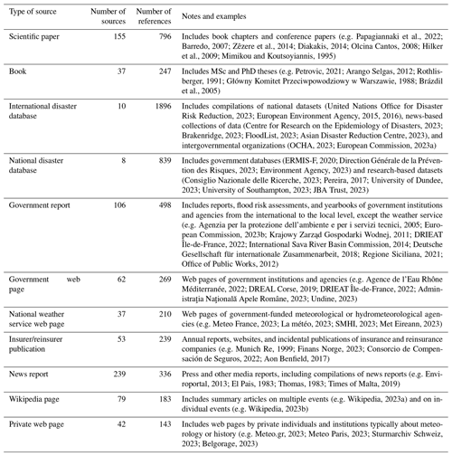
Most of the data were collected from sources in national or regional languages rather than in English. International disaster databases and scientific papers provided large amounts of information in English, but they needed to be supplemented by national sources (mainly government and news media) for verification. Sources were recorded separately for each flood event to ensure transparency and enable users to quickly access more detailed descriptions of the events. A full bibliography was assembled together with a classification of the sources. Table 1 lists the different types of sources used and their frequency together with citations of some of the most frequently consulted sources in the making of the database. In total, there were 828 sources referred to 5654 times (2.2 sources per flood event). News reports, scientific papers, and government reports were the most numerous, but the international and national disaster databases were the most frequently cited, constituting almost half of the references. The flood and landslide database of Consiglio Nazionale delle Ricerche (2023), though it only covers Italian events before 2003, is the most frequently cited resource in HANZE.
2.3 Database contents
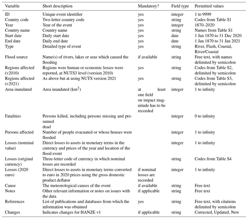
A summary of all fields recorded in the database is provided in Table 2. Providing information for all fields is required for each event unless otherwise noted in the table under the Mandatory? field. This is relevant as the lack of mandatory information excludes an event from the database (see Sect. 2.1.2), while the lack of information in an optional field does not. Some text fields can only use codes from a dictionary, which is contained in a separate set of tables in the dataset that are numbered S1 to S4 (see Sect. 5). Detailed definitions of each field and the discussion on the treatment of non-standard cases are provided in Appendix A.
The HANZE database (v2) contains a total of 2521 flood events. Almost 49 % of events are flash floods followed by riverine floods (46 %), with coastal and compound floods constituting only 4 % and 2 %, respectively. In this section, we analyse the distribution of flood events and fatalities. We do not analyse the other impact variables here due to lower data completeness than of those for fatalities, which are available for 99 % of events. Analysing trends and distribution of impacts needs to consider the changing availability of data over time and space as well as long-term trends in exposure. Such analysis, as in Paprotny et al. (2018b) for HANZE v1, is out of the scope of this study.
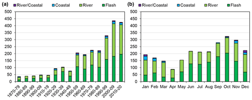
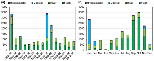
Figure 2Number of reported flood fatalities in the HANZE v2 database by decade (a) and by month (b) (1870–2020).
3.1 Temporal distribution
The contents of HANZE v2 are presented in Figs. 1 and 2 according to their temporal distribution using the start date. All graphs show the flood events split by type, indicating the number of events (Fig. 1) and flood fatalities (Fig. 2). The number of events over time is strongly influenced by data availability, strongly improving from ca. 1950 and then again from ca. 1990. Nonetheless, it is relatively complete in major flood events, with no increase in flood fatalities (not adjusted for changes in exposure or vulnerability). The distribution of events by month is more consistent and clearly follows an annual cycle from a minimum in April to a maximum in October. Coastal floods in the North Sea in 1953 and 1962 are clear outliers in the temporal distribution.
3.2 Spatial distribution
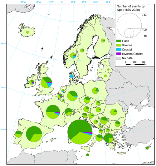
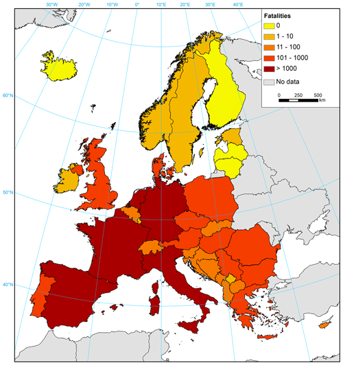
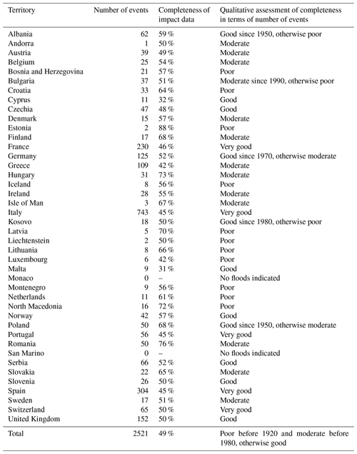
HANZE contains at least one flood event for 40 out of 42 countries in the domain. With the most comprehensive sources, Italy has the highest number of events by far – 743 compared to 304 in Spain, 230 in France, and 152 in the United Kingdom (Fig. 3). However, Spain has a slightly higher total number of reported fatalities (4395) than Italy (4167) (Fig. 4). Large numbers of fatalities were also recorded in France (2130), the Netherlands (1919), and Germany (1325), though in the case of the Netherlands, almost all fatalities are due to a single event (the 1953 North Sea flood). By contrast, very few floods were recorded in most of northern Europe due to the dominance of long but not intense snowmelt floods and low population density limiting the chance of significant socioeconomic impacts. In southern Europe, flash floods strongly dominate, while in other parts of the continent, slow-onset river floods are more frequent. Coastal floods form a noticeable share of events only in a few countries, located primarily along the North Sea. Finally, compound (river–coastal) floods can be found mostly along the coasts of the open Atlantic Ocean and western part of the Mediterranean Sea.
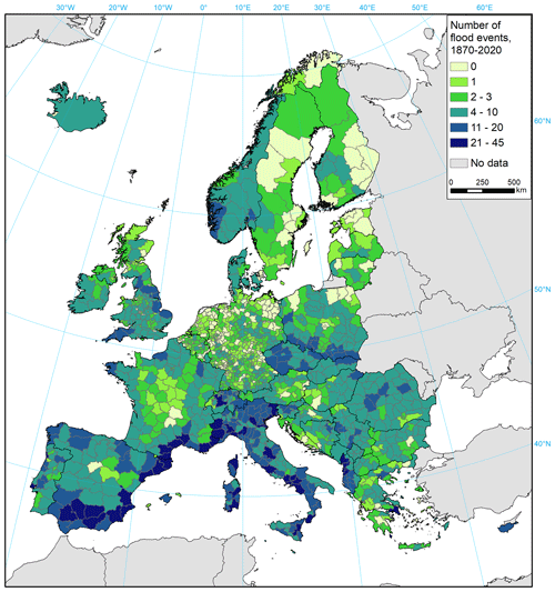
Figure 5Number of flood events in HANZE v2 by region (HANZE subnational units, v2010), total 1870–2020.
The distribution of events, of course, is affected by data availability, which is highly uneven between countries. At the regional level within individual countries, there is rather limited bias. The data by region (Fig. 5) show important differences in distribution of events due to the occurrence of major features. In Spain; France; and, to a lesser extent, in the United Kingdom, the events are concentrated along the coastlines, which is not less related to the occurrence of coastal floods than to higher precipitation compared to inland areas. More frequent flood events are also noticeable along major mountain ranges: Alps, Dinaric Alps, Carpathians, and Sudetes.
4.1 Comparison with other impact datasets
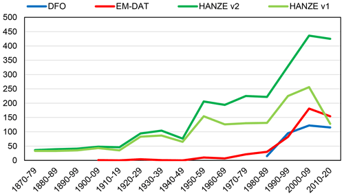
Most commonly used datasets on flood impacts are EM-DAT (Centre for Research on the Epidemiology of Disasters, 2023) and DFO (Brakenridge, 2023). The DFO dataset starts in 1985, while EM-DAT nominally has coverage starting in 1900, though, in practice, contains very few events before the database's inception in the 1980s. Excluding events without any impact data and considering only the HANZE domain, EM-DAT has 74 events before 1990 compared to merely 15 in DFO but 18 times fewer than in HANZE (1305 events before 1990). Over the last 30 years, the difference is much smaller at about 3-fold between HANZE and the other two datasets (Fig. 6). HANZE already contains more events in the 1950s than either DFO or EM-DAT in the decade with the most data (2000–2009). On the other hand, the other datasets have somewhat different inclusion criteria and definitions of floods, with DFO usually aggregating impacts for multiple countries into one record. Additionally, they have the advantage of being continuously updated compared to this one-off update of HANZE.
A more direct comparison with EM-DAT was carried out. Out of 528 EM-DAT floods in the HANZE domain until the year 2020, 479 were found to correspond to 468 HANZE floods. The remaining 49 floods in EM-DAT were not in HANZE for several reasons:
-
Twenty-two events were without impact data in EM-DAT, and their impacts could not be added from other sources.
-
Seven events were below HANZE impact thresholds (Sect. 2.1.2).
-
Seven flood events were outside the scope of HANZE (due to a dam break, urban flood, or hiking accident).
-
Eight events were verified by other sources as being primarily or entirely driven by non-flood impacts (landslide, windstorm, hail, or storm at sea).
-
Five events could not be confirmed by other sources or were indicated as bogus by other sources.
Table 3Example major differences between impact data in HANZE and EM-DAT. Events in italics were excluded from HANZE.
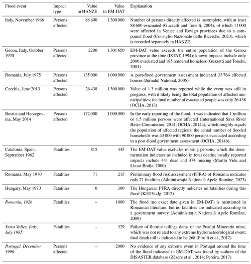
For EM-DAT floods found in HANZE, impact data were often different due to the use of more detailed, country-specific sources in HANZE. In cases where EM-DAT had an impact statistic, fatalities are different in HANZE in ca. 50 % of cases, persons affected in ca. 60 % of cases, and economic loss in ca. 40 % of cases. The difference is at least partially methodological: all impacts of a multi-hazard event are included in an EM-DAT record, while the non-flood impacts were removed in HANZE if possible. The definition of persons affected also could differ due to the use of a different multiplier in EM-DAT for flooded households or because the population of entire administrative districts was sometimes used as affected persons. The latter has probably the most significant influence on analysis of flood impact trends as out of 11.6 million total affected persons in EM-DAT, more than half (5.9 million) are contained in just five floods. In HANZE, only about 420 000 persons are indicated as directly affected for those events. These cases are further explained in Table 3 together with a few other examples of major differences between the datasets.
The above comparison excludes floods classified as windstorms in EM-DAT, which happens in the case of coastal floods in particular. Additional difference between HANZE and EM-DAT worth mentioning is the handling of economic losses. In EM-DAT, nominal losses are recorded in US dollars and then inflation-adjusted using the consumer price index for the United States. Such adjustment is incorrect as it would unrealistically assume that price levels in all countries never change relatively to the United States. In HANZE, losses are recorded in local currency, then adjusted using the gross domestic product deflator specific for each country, and then converted to euro using exchange rates in 2020.
In a recent database, FFEM (Papagiannaki et al., 2022), data on 1524 fatalities since 1980 in nine countries also covered by HANZE were collected. In the case of two countries (France and Spain), only some parts were included in FFEM. Overall, there are more fatalities indicated in HANZE (1796) than in FFEM apart from in some countries (Cyprus, Czechia, Portugal). The difference is partially methodological as certain fatalities in FFEM were found to be outside the definition of fatality used in this study (Sect. A12). Otherwise, it was the result of FFEM being the only source of information that was traced; FFEM itself does not include enough information to fulfil all inclusion criteria (Sect. 2.1.2).
Table 4Comparison in the number of fatalities and number of events with 10 or more fatalities within the HANZE study area since 1980 between FFEM, this study, and EM-DAT. Number of events in FFEM and EM-DAT is given as per Papagiannaki et al. (2022).
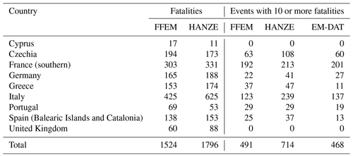
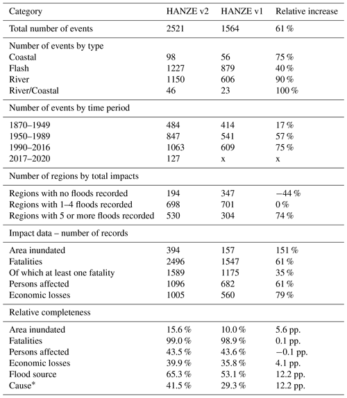
Table 5Comparison between HANZE v2 (this study) and v1 (Paprotny et al., 2018a), with the numbers indicated by the asterisk excluding simplified information on the cause, consistent with the flood type and inserted due to a lack of more precise information (see Appendix A, Sect. A17). Here, pp. stands for percentage points.
4.2 Comparison with HANZE v1
This major revision of HANZE greatly improved the coverage and completeness of the dataset (Table 5). This is largely thanks to the incorporation of a bigger number of sources – 828 compared to 307 in v1. Out of 1564 events in HANZE v1, 698 (45 %) were revised by revisiting the original sources or updated with new information (as indicated by the Changes field). Apart from the Changes field, one new field was introduced in HANZE v2, i.e. regions affected based on NUTS version 2021. Where there were boundary changes in regions between versions 2010 and 2021, the original data sources were revisited to correctly georeference impacts in the new map of regions.
Further 29 events of HANZE v1 were removed for various reasons:
-
14 events due to the merging of two HANZE records;
-
seven events due to stricter imposition of impact thresholds (Sect. 2.1.2) compared to v1;
-
eight events verified, thanks to additional sources, as being outside the scope of the dataset – three urban floods and five events where the impacts were driven mainly by non-flood events (landslides, whirlwinds, or hail).
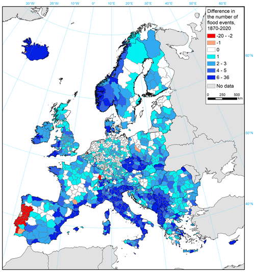
Figure 7Difference in total number of impacts per region in HANZE database between v2 (this study) and v1 (Paprotny et al., 2018a).
For transparency, the deleted records with explanations were included in the dataset in Table S7. The total number of new events is 986, of which 192 are in the six countries not included in HANZE v1. Thanks to improvement of spatial coverage, only 194 regions (v2010 map) show no flood events in HANZE v2, which is down from 347 previously, despite adding 70 regions through the extension of the domain. The average number of floods per region increased from 3.1 to 5.0, with 64 % of regions in HANZE v1 having more events in HANZE v2. The only major exception is Portugal (Fig. 7) as originally most footprints were based on Zêzere et al. (2014), who classified them only by upper-level administrative districts. In HANZE v2, the footprints were completely revised using detailed geocoded impacts by Pereira (2017). Overall, the verification of the impact regions from various sources caused a decline in the number of floods in 39 regions (3 %), of which 25 are in Portugal.
The completeness of the database has improved, though fatalities are still the only impact statistic available for almost all events. Supplementary information such as flood source and detailed cause are also more frequently available than in HANZE v1 despite lower priority being given to obtaining such data.
4.3 Limitations and uncertainties
The dataset was compiled from many sources with a varying level of reliability and completeness. The availability of information also strongly varies between countries and sometimes also within countries. The temporal bias is really noticeable and was analysed for the original HANZE dataset in Paprotny et al. (2018b). The analysis of the distribution of exposure-adjusted loss has shown that there was almost zero trend in the occurrence of the 20 % of floods in HANZE with the biggest impacts. It was noticeable that the lower the impact, the stronger the upward trend. Assuming that HANZE captured all 1990–2016 flood events as well as those belonging to the upper 20 % by impact back to 1870, the missing losses for known events were gap-filled and the losses for unreported events estimated by further assuming that their relative distribution by size of impact should remain unchanged over time. Under such conditions, HANZE v1 missed an estimated 46 % of flood events since 1870, therefore constituting only 20 % of the “real” normalized impacts of floods in Europe. An even bigger impact on estimating the total normalized losses were missing impact data for known events, ranging from less than 10 % for fatalities to almost 60 % of the real impacts for the inundated area. Except for fatalities, reported losses in HANZE v1 covered less than half of the estimated true flood impacts. With the large improvement to the amount of data, HANZE v2 should achieve better results, though the largest additions of new events were again concentrated in the recent 3 decades. This indicates that more research effort is needed to obtain older sources of information and also to reduce the spatial bias between countries where comprehensive data are available (particularly France, Italy, Spain, Portugal, and Switzerland, but also Albania, Poland, Romania, Serbia, and Slovenia) and those with limited or very scattered information (e.g. Baltic states, Germany, the Netherlands, Sweden, and the United Kingdom). A qualitative assessment of how complete the data sources were in the context of the number of events is provided in Table 6 together with the quantitative completeness of the four impact statistics.
Further uncertainties stem from the quality of the data itself. As described in Sect. 4.1, many differences were noticed between EM-DAT and HANZE, and that is only one example comparison. In a limited number of cases, this could be explained by different inclusion thresholds, but overall, HANZE has less strict criteria regarding the minimum magnitude of floods that warrants adding them to the database compared to other databases. For instance, 36 % of events in HANZE had no fatalities, whereas the FFEM database is limited to events leading to fatalities. Among the largest issues are co-occurring hazards, which can strongly distort data on fatalities and economic losses. Whenever possible, attempts were made to indicate such instances and remove non-flood impacts, but often it was not possible due to the lack of detailed descriptions of the events. Other uncertainties involve data from news reports made while the events were ongoing, which might differ from the final tally made in post-flood damage surveys; problems with assigning imprecise location information to HANZE regions; or difficulty of distinguishing between riverine and flash types (or coastal and compound) of some floods. Most important problems are indicated in the Notes field, but a larger discussion on differences between sources for a particular event was avoided. The priority was given to make the database readily usable for statistical analyses and application to pan-European flood studies. Users of the database can consult the references cited individually for each event, which is a noticeable difference from many other flood datasets.
Table 7List of files for download from the HANZE database repository (https://dx.doi.org/10.5281/zenodo.8410025). All .csv files are comma-delimited and coded in UTF8. All .zip files contain a set of files constituting together an ESRI shapefile.
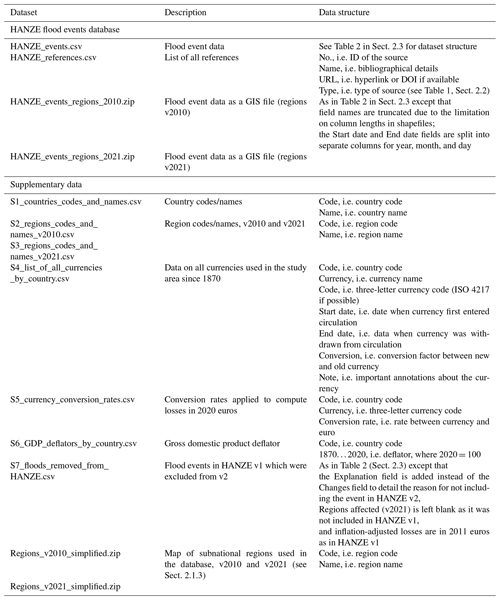
The HANZE database is available from Zenodo repository at https://doi.org/10.5281/zenodo.8410025 (Paprotny, 2023a). It consists of eight comma-delimited text files and four GIS files (Table 7). Apart from the main database, a table with the full bibliography as well as six tables with supplementary information are included. Of the latter, four tables (S1–S4) include codes used in particular fields of the database (see Table 2, Sect. 2.3), two tables (S5 and S6) are used for the conversion of nominal currencies to 2020 euros (see Appendix A, Sect. A16), and one table (S7) contains those records from HANZE v1 which were not included in this update (see Sect. 4.2). The GIS files not only contain the information for the database, but also include a polygon per each event consisting of affected regions in two versions (2010 and 2021 map). The geometry of the regional boundaries is simplified to reduce the file size, and the maps of all regions are also included in the supplementary data.
Additionally, the HANZE database can be viewed online at https://naturalhazards.eu/ (Paprotny, 2024). It includes the following functionalities:
-
Database. An interactive table with the most relevant fields from HANZE. The table can be sorted, searched through by keywords, and filtered (by years, countries, and types). Clicking on the Detail option for a particular event leads to a subpage in which the full HANZE record is displayed together with a map showing the location of affected regions. For a better user experience, regions affected and currencies are converted from codes to full names in these event pages. Clicking on a region's name highlights it in a different colour on the map.
-
Map. An interactive map which displays all affected regions for events fulfilling the search criteria (years, countries, and types). On the map, each region can be clicked, which shows a pop-up indicating the number of events affecting that region within the search criteria and a link that enables displaying the table of all events in the region. By default, the map displays a cartogram of all events between 1870 and 2020.
-
List of references. A table that is sortable and searchable through by keywords containing full bibliographical details and links to sources used in HANZE.
The web page also provides general information on the other aspects of the HANZE database, such as the associated exposure data (Paprotny and Mengel, 2023).
Code used for aggregating HANZE data by region and generating the GIS version of the dataset is available on Zenodo at https://doi.org/10.5281/zenodo.8223833 (Paprotny, 2023b).
The collection of historical flood impact data is a challenge involving searching, verifying, and homogenizing information from a variety of sources. Strong differences in the availability of information between countries and the bias towards recent events complicate spatial and temporal analyses of the data. Nonetheless, HANZE is a significant contribution in the flood research field. With more than 2500 events spread over some 1400 regions and containing nearly 5000 impact data points, it is by far the largest flood impact dataset available for Europe. Together with the associated historical exposure data (Paprotny and Mengel, 2023), it is an essential step towards impact attribution of historical events beyond singular case studies. It also enables studying compound, cascading, and consecutive events. The dataset is also a template for future extensions into other types of hazards, supporting broader pan-European natural hazard modelling efforts.
Fields contained in HANZE, briefly defined in Sect. 2.3, are explained here in detail.
A1 ID
This field provides a unique numeric identifier of each event. Floods that also occur in the original HANZE dataset from 2017 have IDs from 1 to 1564, while new additions have IDs from 2000 upwards.
A2 Country code
This field contains the two-letter country code in which the event occurred. The codes are consistent with NUTS-0 codes rather than ISO 3166-1 codes. The difference between the two is that EL is used for Greece instead of GR, UK is used for the United Kingdom instead of GB, and XK is used for Kosovo (missing in the ISO standard). The list of all codes is included in the database in Table S1.
In the case of events occurring in countries which do not exist anymore (e.g. Czechoslovakia, German Democratic Republic, the Soviet Union, or Yugoslavia), the appropriate successor state is assigned. If an event affected the territory of more than one successor state before the dissolution of the predecessor (e.g. Slovenia and Croatia while part of Yugoslavia), the event was recorded only if it was possible to create entries in which the impacts are recorded using the modern country divisions. In the case of boundary changes of countries existing presently, the country is assigned according to the political divisions at the time of the event. For instance, a flood in Alsace between 1871 and 1918 will be recorded as an event in Germany even if it is presently part of France and the appropriate NUTS regions for France are assigned. Similarly, floods along most of the Oder River will be recorded under Poland after 1945 and Germany before that year.
A3 Year
This field denotes the year in which the event occurred based on the starting date.
A4 Country name
This field contains the country name in which the event occurred according to rules explained in Sect. A2.
A5 Start date
This field contains the exact date on which the event started, which will preferably be the first day on which impacts were reported in the country affected. Therefore, it can differ between countries affected by the same extreme hydrological event. If the exact date is not available or unclear, the best possible approximation was made, and information about this was recorded in the Notes field. If no information about the date is available, the first day of the month was inserted and information about this was recorded in the Notes field. Events for which even the month is not reported were not included in the database.
A6 End date
This field denotes the exact date on which the event ended. If no information about the daily date is available and could not be approximated, the last day of the month was inserted, and information about this was recorded in the Notes field. The end date could possibly stretch into 2021 as long as the start date was within 2020 or the peak intensity of the event occurred within 2020. However, no such case was actually recorded in the dataset.
A7 Type
This field specifies the type of flood event based on the driver of impacts. River and Flash floods were distinguished between according to the duration of the triggering meteorological event: if it lasted no more than 24 h, the event was considered a Flash flood; otherwise, it was considered a River flood. Compound floods were recorded as the River/Coastal type to avoid confusion as to the meaning of compound flood. This type was assigned only if the description of the event indicated that both riverine and coastal flooding contributed to the impacts. If high river flows and a storm surge merely coincided and only one of the two caused the vast majority of losses, the event was assigned to the Coastal, River, or Flash type.
A8 Flood source
This field records the names of the main rivers, lakes, seas, or other coastal basins which have overflown to inundate land and cause impacts. Along the coastline, typically only one sea or other important nautical division (e.g. Bay of Biscay, English Channel, or Danish straits) is involved. Inland, many sub-catchments are typically affected by a flood; therefore, only a few of the most important rivers are listed. Multiple names are separated by semicolons.
A9 Regions affected (v2010)
The location of the impacts was recorded using the HANZE map of subnational units (regions) based mostly on the 2010 version of NUTS level 3 classification (see Sect. 2.1.3 and Table S2 in the dataset). An impact at the regional level is defined as the same as at country level and denotes the occurrence of damages (fatalities, injuries, evacuations, or damage to/destruction of assets). In practice, any region reported as affected by news media is usually recorded here. If more detailed per-region losses were reported, only regions where the vast majority (more than 90 %) of losses occurred were included. Also, only if more detailed information is available did the list of regions affected include any region that recorded significant impacts defined as one of the following:
-
at least 2.5 km2 of land inundated,
-
at least one person killed or missing,
-
at least 13 households or 50 people evacuated or whose houses were flooded,
-
losses in monetary terms corresponding to at least 250 000 euro in 2020 prices.
Except for fatalities, the thresholds equal one-fourth of the event-level thresholds (Sect. 2.1.2). In the case of an event affecting several regions of a country, when the availability of impact data per region was uneven, it was split into separate HANZE events, one for a particular set of regions each.
A10 Regions affected (v2021)
This field is recorded in the same way as the previous one (Sect. A9), with the difference that a different map of regions is used, this time based on the 2021 version of NUTS level 3 classification rather than the 2010 version (see Sect. 2.1.3 and Table S3 in the dataset).
A11 Area inundated
The total area of land inundated during the flood event. Preferably, this included all types of land. However, more often than not, only the agricultural land flooded was reported. As agricultural land is nonetheless the most typical land use in Europe, the value was recorded as is, with no mention of this slight inconsistency in the Notes field.
A12 Fatalities
This field records the number of people killed in connection to the event. It might involve not only resident population, but also tourists, transients, or emergency responders. Persons missing but presumed dead were also included in the total. However, certain flood-related cases of fatalities were excluded here:
-
fatalities by wave action at the coast, where persons were swept away by waves while standing on piers, waterfronts, beaches, etc. (e.g. cause of several fatalities in Ireland; see O'Brien et al., 2018);
-
fatalities by structural collapse of houses caused by heavy rainfall (e.g. several instances in Malta; see Times of Malta, 2019);
-
fatalities related to sports activities in remote areas, such as canoeing or hiking, in connection to sudden and localized flash floods as they cannot be reliably modelled in terms of both hazard and exposure – e.g. Switzerland 1999 (21 fatalities; Sturmarchiv Schweiz, 2023), Greece 2007 (8 fatalities; Meteo.gr, 2023), or Italy 2018 (10 fatalities; FloodList, 2023);
-
fatalities that could be attributed to accidents (particularly vehicular) in connection to very localized bad weather rather than directly caused by flooding (e.g. many cases reported in the UK; see Thomas, 2000).
In contrast to other fields recording impacts, it is allowed for the value of 0 to be recorded here if it is known for certain that the event involved no fatalities. However, in such a case, at least one other field related to impacts had to be recorded. If the number of fatalities was unknown or highly uncertain, the field was left blank, with the Notes field recording what is known in connection to the occurrence of fatalities (such as the minimum number of known/probable fatalities).
A13 Persons affected
The number of persons affected is reported in various ways depending on the source. Here, we used either the number of persons evacuated or the number of homes inundated. If the number of houses (or buildings, households, dwellings, or similar expressions) is reported rather than the population living in them, the number of persons was estimated by multiplying the number of houses by 4. The persons evacuated or affected by inundation typically overlap; therefore, if both were reported, the higher number was used and not a summation of the figures. Similarly, the number of injured people, if available, was not added to the number of persons affected nor recorded if it is the only statistic available. For major flood events, if both the number of flooded and evacuated households were available, the number of evacuations was additionally recorded in the Notes field.
A14 Losses (nominal value)
The monetary estimate of losses from a flood is recorded here. This includes only the direct losses of tangible assets (buildings, other structures, contents of those, vehicles, livestock, or permanent crops). Losses to inventories (such as non-permanent crops or finished manufactured goods) as well as indirect losses (effects of interruptions to the normal functioning of the economy) were excluded, though, in practice, only in very rare instances were such data published (e.g. Chatterton et al., 2010). In this field, the numeric value of the loss estimate was inserted, while the currency to which the number refers to is recorded separately (see Sect. A15). The value represents the currency that was used at the location and time of the event. If the source did not provide the loss estimate in the required currency, the value was recalculated using exchange rates at the time of the event (obtained from various economic data sources; see Paprotny and Mengel, 2023). On rare occasions, the sources reported losses at a price level of a different year than when the event occurred; hence, it was adjusted using gross domestic product deflators (see Sect. A16).
Insured losses are sometimes available instead of total losses, but they were not used due to limited coverage of flood insurance in most countries. Exceptions were made for compensated losses paid through comprehensive government schemes in Denmark (coastal floods only), Norway, and Spain, which often exceeded alternative estimates of total losses. Such instances were indicated in the Notes field.
A15 Losses (original currency)
This field records the currency in which the nominal value of estimated losses was inserted in the previous field (Sect. A14). The currency is reported with a three-letter code, a complete list of which is provided in the dataset in Table S4. The list was adapted from Paprotny and Mengel (2023). For most currencies, the codes are the same as in the international standard ISO 4217, though several historical currencies were assigned artificial codes that follow a similar pattern; i.e. the first two letters identify the country and the third letter the currency.
A16 Losses (2020 euro)
Here, the monetary estimate of losses from previous fields (Sects. A14 and A15) is standardized to a single currency and price level. This is done by recalculating the nominal losses to euros at the 2020 price level and exchange rates. Firstly, the nominal value is converted from the local currency of the time of the event to euros using conversion rates in Table S5. Then, it is converted to the 2020 price level by applying gross domestic product (GDP) deflators from Paprotny and Mengel (2023). For example, a loss of PLZ 100 000 000 000 (100 billion “old” złoty) in 1992 converts to PLN 10 000 000 (10 million złoty) and then to EUR 2 250 731 according to Table S5. The deflator for Poland for 1992 is 16.504 (Table S6), where the year 2020 equals 100; therefore, the following calculation is made:
In this example, the value of 13 637 229 would be recorded in this field.
A17 Cause
Meteorological extremes observed during the event are recorded here. If known, the maximum intensity or the total amount of precipitation was recorded in millimetres per time unit unless the event was caused by snowmelt or ice jam. In the case of coastal floods, the maximum surge heights or wind speed was provided if available. If no specific data are available, a generic text was inserted according to the type of event: extreme rainfall (intense but short duration) for flash floods, heavy rainfall (less intense but of longer duration) for river floods, and storm surge for coastal floods.
A18 Notes
This optional field records other information that is relevant for the event but cannot be included in any other field. Such cases include but are not limited to information that
-
the daily date of the start/end of the event is not exact but approximate or assigned to the first day of the month (see Sects. A5 and A6);
-
the impact data for all/selected fields include, or likely include, impacts of co-occurring hazards (see also Sect. 2.1.2);
-
the impact data are limited to only part of the affected area (i.e. not all affected regions);
-
economic loss pertains to damages compensated through a comprehensive government scheme;
-
there are quality issues (incompleteness, low reliability) with the recorded impact data.
The field was also filled in particularly if the following information was available:
-
co-occurrence of related events (with significant impacts) such as landslides, mudslides, lightning strikes, or hail;
-
impacts of those co-occurring hazards;
-
occurrence of major flood defence/control breaches (dam breaks or a large number of dike failures);
-
occurrence of multiple flood waves within one event;
-
estimated return period of events or other statistical information indicating the extremity of the event not recorded under the Causes field (see Sect. A17).
Other information of high relevance and within the scope of the study not mentioned above were also at times recorded while keeping in mind the need to keep this field concise and prioritizing the mandatory fields.
A19 References
All sources that were used to compile the record of an event are listed here. They are recorded in the standard author–year format, e.g. European Commission (2023b) or Papagiannaki et al. (2022). Individual sources are separated by semicolons. The full bibliographic details of the sources are kept in a separate table in the database (see Sect. 5), including the DOI (if available) or URL as well as the classification of the type of source (as in Table 1; Sect. 2.2).
A20 Changes
This field indicates whether the record differs from HANZE v1. The record is not considered changed when adding “Regions affected (v2021)”, correcting typos in the optional fields, or updating the list of references without modifying other data. Changes made by revisiting previously indicated sources are indicated by Corrected, while those made by consulting additional sources are indicated by Updated. New events are indicated by New and those left unchanged by a blank field.
DP developed the concept, implemented the methods, collected and processed the data, and acquired funding. PT and JŚ created the online database and its visualization. All authors wrote the paper.
The contact author has declared that none of the authors has any competing interests.
Publisher's note: Copernicus Publications remains neutral with regard to jurisdictional claims made in the text, published maps, institutional affiliations, or any other geographical representation in this paper. While Copernicus Publications makes every effort to include appropriate place names, the final responsibility lies with the authors.
This article is part of the special issue “Methodological innovations for the analysis and management of compound risk and multi-risk, including climate-related and geophysical hazards (NHESS/ESD/ESSD/GC/HESS inter-journal SI)”. It is not associated with a conference.
The authors would like to thank Belinda Rhein for her assistance in data collection and Matthias Mengel, Mahé Perrette, and Luc Feyen for technical discussions.
This research has been supported by the Deutsche Forschungsgemeinschaft (grant no. 449175973). The open access is co-funded by the Open Access Fund of the Leibniz Association and the COMPASS project which has received funding from the European Union's HORIZON research and innovation action programme (grant no. 101135481).
The publication of this article was funded by the Open Access Fund of the Leibniz Association.
This paper was edited by Christof Lorenz and reviewed by three anonymous referees.
Administraţia Naţională Apele Române: Studii Privind Determinarea Actiunilor, Masurilor, Optiunilor si Solutiilor Pentru Atingerea Obiectivelor Gestionarii Intergratea a Resurselor de Apa Aple Bazinelor Hidrografice Districtulde de Bazon Hidrografic Olt, Volumul 6: Managementul Risculuila Inundati, Institutul Naţional de Hidrologie şi Gospodărire a Apelor, Budapest, Romania, 2009.
Administraţia Naţională Apele Române: Directiva inundații 2007/60/CE, Administraţia Naţională Apele Române, https://rowater.ro/activitatea-institutiei/departamente/managementul-situatiilor-de-urgenta/directiva-inundatii-2007-60-ce/ (last access: 4 November 2024), 2023.
Agence de l'Eau Rhône Méditerranée: Evaluation Préliminaire des Risques d'Inondation (EPRI), Préfet Coordonnateur de Bassin Rhône-Méditerranée, https://www.rhone-mediterranee.eaufrance.fr/gestion-de-leaugestion-des-risques-dinondationevaluation-preliminaire-des-risques-dinondation-epri (last access: 31 July 2023), 2022.
Agenzia per la protezione dell'ambiente e per i servizi tecnici: Annuario dei dati ambientali – editione 2004, APAT, Rome, Italy, 2005.
Andres, N. and Badoux, A.: The Swiss flood and landslide damage database: Normalisation and trends, J. Flood Risk Manag., 12, e12510, https://doi.org/10.1111/jfr3.12510, 2019.
Aon Benfield: 2016 Annual Global Climate and Catastrophe Report, Aon Benfield, https://www.insurance-canada.ca/wp-content/uploads/2017/01/Aon-Catastrophe-Report-Global-Economic-Losses-1701.pdf (last access: 31 July 2023), 2017.
Arango Selgas, A. M.: Impacto de las inundaciones en España: 1990–2010, MSc thesis, University of Oviedo, Oviedo, Spain, 2012.
Asian Disaster Reduction Centre: GLIDEnumber, Asian Disaster Reduction Centre, https://glidenumber.net/glide/public/search/search.jsp (last access: 31 July 2023), 2023.
Barendrecht, M. H., Viglione, A., Kreibich, H., Merz, B., Vorogushyn, S., and Blöschl, G.: The value of empirical data for estimating the parameters of a sociohydrological flood risk model, Water Resour. Res., 55, 1312–1336, https://doi.org/10.1029/2018WR024128, 2019.
Barredo, J. I.: Major flood disasters in Europe: 1950–2005, Nat. Hazards, 42, 125–148, https://doi.org/10.1007/s11069-006-9065-2, 2007.
Barredo, J. I.: Normalised flood losses in Europe: 1970–2006, Nat. Hazards Earth Syst. Sci., 9, 97–104, https://doi.org/10.5194/nhess-9-97-2009, 2009.
Barredo, J. I., Saurí, D., and Llasat, M. C.: Assessing trends in insured losses from floods in Spain 1971–2008, Nat. Hazards Earth Syst. Sci., 12, 1723–1729, https://doi.org/10.5194/nhess-12-1723-2012, 2012.
Belgorage: Almanach des orages jusque 2000, Belgorage, https://belgorage.be/dossier/almanach-des-orages-jusque-2000 (last access: 31 July 2023), 2023.
Black, A. R. and Law, F. M.: Development and utilization of a national web-based chronology of hydrological events, Hydrolog. Sci. J., 49, 237–246, https://doi.org/10.1623/hysj.49.2.237.34835, 2004.
Boulange, J., Hanasaki, N., Yamazaki, D., and Pokhrel, Y.: Role of dams in reducing global flood exposure under climate change, Nat Commun., 12, 417, https://doi.org/10.1038/s41467-020-20704-0, 2021.
Brakenridge, G. R.: Global Active Archive of Large Flood Events, Dartmouth Flood Observatory, University of Colorado, Boulder, USA, http://floodobservatory.colorado.edu/Archives/index.html (last access: 26 July 2023), 2023.
Brázdil, R., Dobrovolný, P., Elleder, L., Kakos, V., Kotyza, O., Květoň, V., Macková, J., Müller, M., Štekl, J., Tolasz, R., and Valášek, H.: Historické a současné povodně v České Republice, Masarykova univerzita v Brně, Ceský hydrometeorologický ústav v Praze, Brno – Praha, Czechia, 2005.
Brázdil, R., Chromá, K., Dolák, L., Řehoř, J., Řezníčková, L., Zahradníček, P., and Dobrovolný, P.: Fatalities associated with the severe weather conditions in the Czech Republic, 2000–2019, Nat. Hazards Earth Syst. Sci., 21, 1355–1382, https://doi.org/10.5194/nhess-21-1355-2021, 2021.
Centre for Research on the Epidemiology of Disasters: Extreme weather events in Europe, CRED Crunch 64, Université catholique de Louvain, https://cred.be/sites/default/files/CredCrunch64.pdf (last access: 8 August 2023), 2021.
Centre for Research on the Epidemiology of Disasters: EM-DAT, CRED, UCLouvain, Brussels, Belgium, https://www.emdat.be/ (last access: 26 July 2023), 2023.
Chatterton, J., Viavattene, C., Morris, J., Penning-Rowsell, E., and Tapsell, S.: The costs of the summer 2007 floods in England. Environment Agency, Bristol, UK, https://www.gov.uk/flood-and-coastal-erosion-risk-management-research-reports/the-costs-of-the-summer-2007-floods-in-england (last access: 4 November 2024), 2010.
Consiglio Nazionale delle Ricerche: Sistema Informativo sulle Catastrofi Idrogeologiche, Consiglio Nazionale delle Ricerche, http://sici.irpi.cnr.it/index.htm (last access: 1 August 2023), 2023.
Consorcio de Compensación de Seguros: Estadística. Riesgos Extraordinarios. Serie 1971–2021, CCS, Madrid, Spain, 2022.
Deutsche Gesellschaft für internationale Zusammenarbeit: Preliminary Flood Risk Assessment for the Drin/Drim – Buna/Bojana River Basin, Deutsche Gesellschaft für internationale Zusammenarbeit, https://www.giz.de/en/downloads/Report%20%E2%80%93%20Preliminary%20Flood%20Risk%20Assessment%20for%20the%20DrinDrim%20%E2%80%93%20BunaBojana%20River%20Basin%20(2018).pdf (last access: 31 July 2023), 2018.
Diakakis, M.: An inventory of flood events in Athens, Greece, during the last 130 years. Seasonality and spatial distribution, J. Flood Risk Manag., 7, 332–343, https://doi.org/10.1111/jfr3.12053, 2014.
Dillenardt, L., Hudson, P., and Thieken, A. H.: Urban pluvial flood adaptation: results of a household survey across four German municipalities, J. Flood Risk Manag., 15, e12748, https://doi.org/10.1111/jfr3.12748, 2022.
Direction Générale de la Prévention des Risques: Base de données historiques sur les inondations, Direction Générale de la Prévention des Risques, https://bdhi.developpement-durable.gouv.fr/ (last access: 31 July 2023), 2023.
Domeneghetti, A., Carisi, F., Castellarin, A., and Brath, A.: Evolution of flood risk over large areas: Quantitative assessment for the Po river, J. Hydrol., 527, 809–823, https://doi.org/10.1016/j.jhydrol.2015.05.043, 2015.
Dottori, F., Alfieri, L., Bianchi, A., Skoien, J., and Salamon, P.: A new dataset of river flood hazard maps for Europe and the Mediterranean Basin, Earth Syst. Sci. Data, 14, 1549–1569, https://doi.org/10.5194/essd-14-1549-2022, 2022.
DREAL Corse: L'évaluation préliminaire des risques d'inondation (EPRI), Préfet de Corse, https://www.corse.developpement-durable.gouv.fr/l-evaluation-preliminaire-des-risques-d-inondation-a1549.html (last access: 31 July 2023), 2019.
DRIEAT Île-de-France: Mise à disposition de l'Evaluation préliminaire des risques d'inondation (EPRI) et de son addendum, Préfet de la Région d'Île-de-France, https://www.drieat.ile-de-france.developpement-durable.gouv.fr/mise-a-disposition-de-l-evaluation-preliminaire-a1074.html (last access: 31 July 2023), 2022.
El Pais: 1.000 muertos por las riadas en los últimos 30 años, El Pais, https://elpais.com/diario/1983/08/28/espana/430869613_850215.html (last access: 31 July 2023), 1983.
Environment Agency: Recorded Flood Outlines, Environment Agency, https://www.data.gov.uk/dataset/16e32c53-35a6-4d54-a111-ca09031eaaaf/recorded-flood-outlines (last access: 31 July 2023), 2023.
Enviroportal: Výberový prehl′ad najväčších povodní na území samostatnej SR od roku 1993, Enviroportal, https://www.enviroportal.sk/clanok/vyberovy-prehlad-najvacsich-povodni-na-uzemi-samostatnej-sr-od-roku-1993 (last access: 31 July 2023), 2013.
ERMIS-F: Flood events, Environmental Risk Management and Information Service – Floods, Interreg Greece-Cyprus, https://ermis-apps.ermis-f.eu/kb/l/FloodIncident/ (last access: 27 July 2023), 2020.
European Commission: List of EMS Rapid Mapping Activations, Copernicus Emergency Management Service – Mapping, https://emergency.copernicus.eu/mapping/list-of-activations-rapid (last access: 31 July 2023), 2023a.
European Commission: Beneficiary States of the EU Solidarity Fund Interventions since 2002 – Only Natural Disasters. April 2023, Directorate-General for EU Regional and Urban Policy, https://ec.europa.eu/regional_policy/sources/funding/solidarity-fund/interventions_natural_disaster.pdf (last access: 31 July 2023), 2023b.
European Environment Agency: Flood phenomena, European Environment Agency, https://www.eea.europa.eu/data-and-maps/data/european-past-floods/flood-phenomena (last access: 26 July 2023), 2015.
European Environment Agency: Reporting obligation for: Floods Directive – Preliminary Flood Risk Assessment and Areas of Potential Significant Flood Risk – 2012, European Environment Agency, https://rod.eionet.europa.eu/obligations/601 (last access: 31 July 2023), 2016.
European Union: Directive 2007/60/EC of the European Parliament and of the Council of 23 October 2007 on the assessment and management of flood risks, OJ L 288, 6 November 2007, 27–34, European Commission, Brussels, Belgium, 2007.
Eurostat: Statistical regions in the European Union and partner countries — NUTS and statistical regions 2021, Publications Office of the European Union, Luxembourg, https://doi.org/10.2785/850262, 2020.
Finans Norge: NASK – Naturskadestatistikk, Finans Norge, https://nask.finansnorge.no/ (last access: 31 July 2023), 2023.
FloodList: Floods and flooding news from around the world, FloodList, https://floodlist.com/ (last access: 31 July 2023), 2023.
Formetta, G. and Feyen, L.: Empirical evidence of declining global vulnerability to climate-related hazards, Global Environ. Chang., 57, 101920, https://doi.org/10.1016/j.gloenvcha.2019.05.004, 2019.
Fuchs, S., Keiler, M., and Zischg, A.: A spatiotemporal multi-hazard exposure assessment based on property data, Nat. Hazards Earth Syst. Sci., 15, 2127–2142, https://doi.org/10.5194/nhess-15-2127-2015, 2015.
Główny Komitet Przeciwpowodziowy w Warszawie: Zarys monografii powodzi w Polsce w 40-lecie działalności Głównego Komitetu Powodziowego, Ministerstwo Ochrony Środowiska i Zasobów Naturalnych, Warsaw, Poland, 1988.
Guzzetti, F. and Tonelli, G.: Information system on hydrological and geomorphological catastrophes in Italy (SICI): a tool for managing landslide and flood hazards, Nat. Hazards Earth Syst. Sci., 4, 213–232, https://doi.org/10.5194/nhess-4-213-2004, 2004.
Haigh, I. D., Ozsoy, O., Wadey, M. P., Nicholls, R. J., Gallop, S. L., Wahl, T., and Brown, J. M.: An improved database of coastal flooding in the United Kingdom from 1915 to 2016, Sci. Data, 4, 170100, https://doi.org/10.1038/sdata.2017.100, 2017.
Hilker, N., Badoux, A., and Hegg, C.: The Swiss flood and landslide damage database 1972–2007, Nat. Hazards Earth Syst. Sci., 9, 913–925, https://doi.org/10.5194/nhess-9-913-2009, 2009.
International Sava River Basin Commission: Preliminary Flood Risk Assessment in the Sava River Basin, July 2014, ISRBC, Zagreb, Croatia, 2014.
ISTAT: Popolazione Residente dei Comuni – Censimenti dal' 1861 al 1991, Istituto nazionale di statistica, Rome, Italy, 1994.
JBA Trust: British Chronology of Flash Floods, JBA Trust, https://www.jbatrust.org/about-the-jba-trust/how-we-help/publications-resources/rivers-and-coasts/british-chronology-of-flash-floods/ (last access: 31 July 2023), 2023.
Jurnalul National: Potopul din '70, Jurnalul National, https://jurnalul.ro/special-jurnalul/potopul-din-a-128-153-70-44767.html (last access: 3 August 2023), 2005.
KöTiVizIg: Előzetes kockázatbecslés Országjelentése. A jelentés a 2007/60/EK Irányelve alapján készült, Közép-Tisza-vidéki Vízügyi Igazgatóság, Budapest, Hungary, 2012.
Krajowy Zarząd Gospodarki Wodnej: Wstępna ocena ryzyka powodziowego, KZGW, Warsaw, Poland, 2011.
Kreibich, H., Blauhut, V., Aerts, J. C. J. H., Bouwer, L. M., Van Lanen, H. A. J., Mejia, A., Mens, M., and Van Loon, A. F.: How to improve attribution of changes in drought and flood impacts, Hydrolog. Sci. J., 64, 1–18, https://doi.org/10.1080/02626667.2018.1558367, 2019.
Kreibich, H., Schröter, K., Di Baldassarre, G., Van Loon, A. F., Mazzoleni, M., Abeshu, G. W., Agafonova, S., AghaKouchak, A., Aksoy, H., Alvarez-Garreton, C., Aznar, B., Balkhi, L., Barendrecht, M. H., Biancamaria, S., Bos-Burgering, L., Bradley, C., Budiyono, Y., Buytaert, W., Capewell, L., Carlson, H., Cavus, Y., Couasnon, A., Coxon, G., Daliakopoulos, I., de Ruiter, M. C., Delus, C., Erfurt, M., Esposito, G., François, D., Frappart, F., Freer, J., Frolova, N., Gain, A. K., Grillakis, M., Grima, J. O., Guzmán, D. A., Huning, L. S., Ionita, M., Kharlamov, M., Khoi, D. N., Kieboom, N., Kireeva, M., Koutroulis, A., Lavado-Casimiro, W., Li, H.-Y., LLasat, M. C., Macdonald, D., Mård, J., Mathew-Richards, H., McKenzie, A., Mejia, A., Mendiondo, E. M., Mens, M., Mobini, S., Mohor, G. S., Nagavciuc, V., Ngo-Duc, T., Nguyen, H. T. T., Nhi, P. T. T., Petrucci, O., Quan, N. H., Quintana-Seguí, P., Razavi, S., Ridolfi, E., Riegel, J., Sadik, M. S., Sairam, N., Savelli, E., Sazonov, A., Sharma, S., Sörensen, J., Souza, F. A. A., Stahl, K., Steinhausen, M., Stoelzle, M., Szalińska, W., Tang, Q., Tian, F., Tokarczyk, T., Tovar, C., Tran, T. V. T., van Huijgevoort, M. H. J., van Vliet, M. T. H., Vorogushyn, S., Wagener, T., Wang, Y., Wendt, D. E., Wickham, E., Yang, L., Zambrano-Bigiarini, M., and Ward, P. J.: Panta Rhei benchmark dataset: socio-hydrological data of paired events of floods and droughts, Earth Syst. Sci. Data, 15, 2009–2023, https://doi.org/10.5194/essd-15-2009-2023, 2023.
Kron, W., Steuer, M., Löw, P., and Wirtz, A.: How to deal properly with a natural catastrophe database – analysis of flood losses, Nat. Hazards Earth Syst. Sci., 12, 535–550, https://doi.org/10.5194/nhess-12-535-2012, 2012.
Lang, M., Coeur, D., Audouard, A., Villanova-Oliver, M., and Pène J.-P.: BDHI: a French national database on historical floods, E3S Web Conf., 7, 04010, https://doi.org/10.1051/e3sconf/20160704010, 2016.
L'Institut Royal Météorologique: Inondations, L'Institut Royal Météorologique, https://www.meteo.be/fr/climat/climat-de-la-belgique/evenements-remarquables-depuis-1901/evenements-remarquables/evenements/inondations (last access: 31 July 2023), 2023.
Martín Vide, J. and Llasat Botija, M. C.: Las Precipitaciones Torrenciales en Cataluña, Serie Geográfica, 9, 17–26, Universidad de Alcalá, Madrid, Spain, 2000.
Mazzoleni, M., Dottori, F., Cloke, H. L., Di Baldassarre, G.: Deciphering human influence on annual maximum flood extent at the global level, Commun. Earth Environ., 3, 262, https://doi.org/10.1038/s43247-022-00598-0, 2022.
Merz, B., Blöschl, G., Vorogushyn, S., Dottori, F., Aerts, J. C. J. H., Bates, P., Bertola, M., Kemter, M., Kreibich, H., Lall, U., and Macdonald, E.: Causes, impacts and patterns of disastrous river floods, Nat. Rev. Earth Environ., 2, 592–609, https://doi.org/10.1038/s43017-021-00195-3, 2021.
Mester, B., Frieler, K., and Schewe, J.: Human displacements, fatalities, and economic damages linked to remotely observed floods, Sci. Data, 10, 482, https://doi.org/10.1038/s41597-023-02376-9, 2023.
Met Eireann: Major Weather Events, https://www.met.ie/climate/major-weather-events/ (last access: 31 July 2023), 2023.
Meteo France: Pluies extrêmes en France métropolitaine, Meteo France, http://pluiesextremes.meteo.fr/france-metropole/-Tous-les-evenements-.html (last access: 31 July 2023), 2023.
Meteo Paris: Chronique météo, Meteo Paris, https://www.meteo-paris.com/chronique (last access: 31 July 2023), 2023.
Meteo.gr: Kairiká epeisódia me koinoniko-oikonomikés epiptóseis stin Elláda apó to 2000, Meteo.gr, https://meteo.gr/weather_cases.cfm (last access: 31 July 2023), 2023.
Metin, A. D., Dung, N. V., Schröter, K., Guse, B., Apel, H., Kreibich, H., Vorogushyn, S., and Merz, B.: How do changes along the risk chain affect flood risk?, Nat. Hazards Earth Syst. Sci., 18, 3089–3108, https://doi.org/10.5194/nhess-18-3089-2018, 2018.
Mimikou, M. and Koutsoyiannis, D.: Extreme floods in Greece: The case of 1994, U. S. – ITALY Research Workshop on the Hydrometeorology, Impacts, and Management of Extreme Floods, 13–17 November 1995, Perugia, Italy, https://doi.org/10.13140/RG.2.1.1945.8802, 1995.
Munich Re: Naturkatastrophen in Deutschland. Schadenerfahrungen und Schadenpotentiale, Münchener Rückversicherungs-Gesellschaft, Munich, Germany, 1999.
Munich Re: NatCatSERVICE, Munich Re, https://www.munichre.com/en/solutions/for-industry-clients/natcatservice.html (last access: 26 July 2023), 2023.
O'Brien, L., Renzi, E., Dudley, J. M., Clancy, C., and Dias, F.: Catalogue of extreme wave events in Ireland: revised and updated for 14 680 BP to 2017, Nat. Hazards Earth Syst. Sci., 18, 729–758, https://doi.org/10.5194/nhess-18-729-2018, 2018.
OCHA: Central Europe: Floods – Jun 2013, United Nations Office for the Coordination of Humanitarian Affairs, https://reliefweb.int/disaster/fl-2013-000068-cze/ (last access: 3 August 2023), 2013.
OCHA: 4 June 2014: Bosnia and Herzegovina – Flood situation & UCPM and bilateral assistance, United Nations Office for the Coordination of Humanitarian Affairs, https://reliefweb.int/map/bosnia-and-herzegovina/4-june-2014-bosnia-and-herzegovina-flood-situation-ucpm-and-bilateral/ (last access: 3 August 2023), 2014a.
OCHA: Bosnia and Herzegovina Recovery Needs Assessment, Floods 14–19 May (Executive Summary), United Nations Office for the Coordination of Humanitarian Affairs, https://reliefweb.int/report/bosnia-and-herzegovina/bosnia-and-herzegovina-recovery-needs-assessment-floods-14-19-may/ (last access: 3 August 2023), 2014b.
OCHA: ReliefWeb, United Nations Office for the Coordination of Humanitarian Affairs, https://reliefweb.int/ (last access: 31 July 2023), 2023.
Office of Public Works: The National Preliminary Flood Risk Assessment (PFRA) - Overview Report, Office of Public Works, https://static-floodinfo.s3-eu-west-1.amazonaws.com/static/floodmaps/docs/about_pages/PFRA_Report.pdf (last access: 31 July 2023), 2012.
Olcina Cantos, J.: Reducción del riesgo de inundaciones en el litotal mediterráneo español. El papel de la ordenación del territorio, in: Riesgo de inundaciones en el Mediterráneo occidental, edited by: Chastagnaret, G. and Gil Olcina, A., Collection de la Casa de Velázquez (95), Madrid, Spain, 157–214, 2008.
Papagiannaki, K., Petrucci, O., Diakakis, M., Kotroni, V., Aceto, L., Bianchi, C., Brázdil, R., Gelabert, M. G., Inbar, M., Kahraman, A., Kılıç, Ö., Krahn, A., Kreibich, H., Llasat, M. C., Llasat-Botija, M., Macdonald, N., de Brito, M. M., Mercuri, M., Pereira, S., Řehoř, J., Geli, J. R., Salvati, P., Vinet, F., and Zêzere, J. L.: Developing a large-scale dataset of flood fatalities for territories in the Euro-Mediterranean region, FFEM-DB, Sci. Data, 9, 166, https://doi.org/10.1038/s41597-022-01273-x, 2022.
Paprotny, D.: HANZE database of historical flood impacts in Europe, 1870–2020 (2.1.1), Zenodo [data set], https://doi.org/10.5281/zenodo.8410025, 2023a.
Paprotny, D.: HANZE v2.1 flood impact model (v2.1), Zenodo [code], https://doi.org/10.5281/zenodo.8223833, 2023b.
Paprotny, D.: HANZE – Historical Analysis of Natural Hazards in Europe, https://naturalhazards.eu/ (last access: 4 November 2024), 2024.
Paprotny, D. and Mengel, M.: Population, land use and economic exposure estimates for Europe at 100 m resolution from 1870 to 2020, Sci. Data, 10, 372, https://doi.org/10.1038/s41597-023-02282-0, 2023.
Paprotny, D., Morales-Nápoles, O., and Jonkman, S. N.: Efficient pan-European river flood hazard modelling through a combination of statistical and physical models, Nat. Hazards Earth Syst. Sci., 17, 1267–1283, https://doi.org/10.5194/nhess-17-1267-2017, 2017.
Paprotny, D., Morales-Nápoles, O., and Jonkman, S. N.: HANZE: a pan-European database of exposure to natural hazards and damaging historical floods since 1870, Earth Syst. Sci. Data, 10, 565–581, https://doi.org/10.5194/essd-10-565-2018, 2018a.
Paprotny, D., Sebastian, A., Morales Nápoles, O., and Jonkman, S. N.: Trends in flood losses in Europe over the past 150 years, Nat. Commun., 9, 1985, https://doi.org/10.1038/s41467-018-04253-1, 2018b.
Paprotny, D., Morales Nápoles, O., Vousdoukas, M. I., Jonkman, S. N., and Nikulin, G.: Accuracy of pan-European coastal flood mapping, J. Flood Risk Manag., 12, e12459, https://doi.org/10.1111/jfr3.12459, 2019.
Paprotny, D., Vousdoukas, M. I., Morales Nápoles, O., Jonkman, S. N., and Feyen, L.: Pan-European hydrodynamic models and their ability to identify compound floods, Nat. Hazards, 101, 933–957, https://doi.org/10.1007/s11069-020-03902-3, 2020.
Pereira, S.: Disaster 1865–2015, ArcGIS Map Viewer, https://www.arcgis.com/home/item.html?id=2a6fad1aa46c40e9a6b5db3ee4257e80 (last access: 31 July 2023), 2017.
Petrovic, A. M.: Bujične poplave u Srbiji, MSc thesis, Srpsko geografsko društvo, Belgrade, Serbia, 2021.
Pielke, R.: Economic `normalisation' of disaster losses 1998–2020: a literature review and assessment, Environ. Hazards-UK, 20, 93–111, https://doi.org/10.1080/17477891.2020.1800440, 2021.
Pirulli, M., Barbero, M., Marchelli, M., and Scavia, C.: The failure of the Stava Valley tailings dams (Northern Italy): numerical analysis of the flow dynamics and rheological properties, Geoenviron. Disasters, 4, 3, https://doi.org/10.1186/s40677-016-0066-5, 2017.
Regione Siciliana: Piano di Gestione del Rischio di Alluvioni. Il sistema di allertamento ai fini di Protezione Civile nella Regione Siciliana. 2o ciclo, Regione Siciliana, https://www.regione.sicilia.it/sites/default/files/2021-12/2%20Relazione%20Il%20Sistema%20di%20Allertamento%20ai%20fini%20di%20Prot%20Civile%20nella%20Regione%20Siciliana%20per%20II%20ciclo%20del%20PGRA.pdf (last access: 31 July 2023), 2021.
Rosenzweig, B., Ruddell, B. L., McPhillips, L., Hobbins, R., McPhearson, T., Cheng, Z., Chang, H., and Kim, Y.: Developing knowledge systems for urban resilience to cloudburst rain events, Environ. Sci. Policy, 99, 150–159, https://doi.org/10.1016/j.envsci.2019.05.020, 2019.
Rosvold, E. L. and Buhaug, H.: GDIS, a global dataset of geocoded disaster locations, Sci. Data, 8, 61, https://doi.org/10.1038/s41597-021-00846-6, 2021.
Rothlisberger, G.: Chronik der Unwetterschaden in der Schweizk, Berichte der Eidgenossischen Forschungsanstalt fur Wald, Schnee und Landschaft, 330, Eidg. Forschungsanstalt WSL, Birmensdorf, Switzerland, 1991.
Sánchez-García, C., Schulte, L., Carvalho, F., and Carlos Peña, J. C.: A 500-year flood history of the arid environments of southeastern Spain. The case of the Almanzora River, Global Planet. Change, 181, 102987, https://doi.org/10.1016/j.gloplacha.2019.102987, 2019.
Sauer, I., Reese, R., Otto, C., Geiger, T., Willner, S., Guillod, B. P., Bresch, D. N., and Frieler, K.: Climate signals in river flood damages emerge under sound regional disaggregation, Nat. Commun., 12, 2128, https://doi.org/10.1038/s41467-021-22153-9, 2021.
Schoppa, L., Barendrecht, M. H., Paprotny, D., Sairam, D., Sieg, T., and Kreibich, H.: Projecting Flood Risk Dynamics for Effective Long-term Adaptation, Earths Future, in review, 2023.
Sebastian, A., Gori, A., Blessing, R. B., van der Wiel, K., and Bass B.: Disentangling the impacts of human and environmental change on catchment response during Hurricane Harvey, Environ. Res. Lett., 14, 124023, https://doi.org/10.1088/1748-9326/ab5234, 2019.
SMHI: Historiska översvämningar, Sveriges meteorologiska och hydrologiska institut, https://www.smhi.se/kunskapsbanken/hydrologi/oversvamningar/historiska-oversvamningar-1.7827 (last access: 31 July 2023), 2023.
Staatliches Amt für Umwelt und Natur Rostock: Sturmflut 2006, Staatliches Amt für Umwelt und Natur Rostock, http://service.mvnet.de/_php/download.php?datei_id=111971 (last access: 31 July 2023), 2007.
Steinhausen, M., Paprotny, D., Dottori, F., Sairam, N., Mentaschi, L., Alfieri, L., Lüdtke, S., Kreibich, H., and Schröter K.: Drivers of future fluvial flood risk change for residential buildings in Europe, Global Environ. Chang., 76, 102559, https://doi.org/10.1016/j.gloenvcha.2022.102559, 2022.
Stevens, A. J., Clarke, D., and Nicholls, R. J.: Trends in reported flooding in the UK: 1884–2013, Hydrolog. Sci. J., 61, 50–63, https://doi.org/10.1080/02626667.2014.950581, 2016.
Sturmarchiv Schweiz: Swiss Severe Weather Database (SSWD), Sturmarchiv Schweiz, https://www.sturmarchiv.ch/index.php?title=Hauptseite (last access: 31 July 2023), 2023.
Swiss Re: Sigma Explorer, Swiss Re, https://www.sigma-explorer.com/index.html (last access: 27 July 2023), 2023.
Thieken, A., Bubeck, P., Zenker, M.-L., and Wutzler, B.: Strukturierte Auswertung der Dokumentationen zu allen Hochwassertodesopfern in Nordrhein-Westfalen im Juli 2021 und Herausarbeitung von Verbesserungspotenzialen in der Risikokommunikation und in den Warnprozessen anhand der Todesumstände und -ursachen sowie Ereignischarakteristika, Gutachten für den Parlamentarischen Untersuchungsausschuss V (Hochwasserkatastrophe) des Landtags Nordrhein-Westfalen, University of Potsdam, Potsdam, Germany, 59 pp., https://www.landtag.nrw.de/files/live/sites/landtag-r20/files/Internet/I.A.1/PUA/PUA_II/Gutachten%20Prof.%20Thieken.pdf (last access: 31 July 2023), 2022.
Thomas, A. J.: World weather disasters: July 1983, J. Meteorol., 8, 257–261, 1983.
Thomas, A. J.: Deaths in Britain from the weather in 1999, J. Meteorol., 25, 246–248, 2000.
Times of Malta: 100 years of storms, and all bar one in October, Times of Malta, https://timesofmalta.com/articles/view/20190301/life-features/rainstorm-related-tragedies-of-the-past-century.703290 (last access: 31 July 2023), 2019.
Undine: Informationsplattform zu hydrologischen Extremereignissen (Hochwasser, Niedrigwasser), Bundesanstalt für Gewässerkunde, https://undine.bafg.de/ (last access: 31 July 2023), 2023.
United Nations Office for Disaster Risk Reduction: United Nations DesInventar Open Source Initiative, United Nations Office for Disaster Risk Reduction, https://www.desinventar.net/ (last access: 27 July 2023), 2023.
University of Dundee: BHS Chronology of British Hydrological Events, University of Dundee, https://www.cbhe.hydrology.org.uk/index.php (last access: 31 July 2023), 2023.
University of Southampton: SurgeWatch – a database of UK coastal events, University of Southampton, https://www.surgewatch.org/ (last access: 31 July 2023), 2023.
Vousdoukas, M. I., Bouziotas, D., Giardino, A., Bouwer, L. M., Mentaschi, L., Voukouvalas, E., and Feyen, L.: Understanding epistemic uncertainty in large-scale coastal flood risk assessment for present and future climates, Nat. Hazards Earth Syst. Sci., 18, 2127–2142, https://doi.org/10.5194/nhess-18-2127-2018, 2018.
Wikipedia: Lista di alluvioni e inondazioni in Italia, Wikimedia Foundation, https://it.wikipedia.org/wiki/Lista_di_alluvioni_e_inondazioni_in_Italia (last access: 31 July 2023), 2023a.
Wikipedia: 2012 Great Britain and Ireland floods, Wikimedia Foundation, https://en.wikipedia.org/wiki/2012_Great_Britain_and_Ireland_floods (last access: 31 July 2023), 2023b.
Zanardo, S., Nicotina, L., Hilberts, A. G. J., and Jewson, S. P.: Modulation of economic losses from European floods by the North Atlantic Oscillation, Geophys. Res. Lett., 46, 2563–2572, https://doi.org/10.1029/2019GL081956, 2019.
Zêzere, J. L., Pereira, S., Tavares, A. O., Bateira, C., Trigo, R. M., Quaresma, I., Santos, P. P., Santos, M., and Verde, J.: DISASTER: a GIS database on hydro-geomorphologic disasters in Portugal, Nat. Hazards, 72, 503–532, https://doi.org/10.1007/s11069-013-1018-y, 2014.


