Articles | Volume 18, issue 11
https://doi.org/10.5194/essd-18-8377-2026
© Author(s) 2026. This work is distributed under
the Creative Commons Attribution 4.0 License.
the Creative Commons Attribution 4.0 License.
https://doi.org/10.5194/essd-18-8377-2026
© Author(s) 2026. This work is distributed under
the Creative Commons Attribution 4.0 License.
the Creative Commons Attribution 4.0 License.
Data description article
| Highlight paper
| 
17 Nov 2026
Data description article | Highlight paper |
| 17 Nov 2026
| 17 Nov 2026
ALPAKAS: Alpine hydrographs and catchment attributes for karst springs

Federal Institute for Geosciences and Natural Resources (BGR), Berlin, Germany
Pauline Thinius
Karlsruhe Institute of Technology (KIT), Institute of Applied Geosciences, Karlsruhe, Germany
Zhao Chen
Dresden University of Technology (TUD), Institute of Groundwater Management, Dresden, Germany
Andreas Hartmann
Dresden University of Technology (TUD), Institute of Groundwater Management, Dresden, Germany
Nico Goldscheider
Karlsruhe Institute of Technology (KIT), Institute of Applied Geosciences, Karlsruhe, Germany
Tanja Liesch
Karlsruhe Institute of Technology (KIT), Institute of Applied Geosciences, Karlsruhe, Germany
Gerhard Schubert
GeoSphere Austria, Vienna, Austria
Stefan Broda
Federal Institute for Geosciences and Natural Resources (BGR), Berlin, Germany
Related authors
Pauline Thinius, Felix Joger, Tanja Liesch, and Nico Goldscheider
EGUsphere, https://doi.org/10.5194/egusphere-2026-5402, https://doi.org/10.5194/egusphere-2026-5402, 2026
This preprint is open for discussion and under review for Hydrology and Earth System Sciences (HESS).
Short summary
Short summary
Karst spring catchments are difficult to delineate because underground drainage does not necessarily follow surface topography. We developed an automated method to approximate catchments using widely available data. Applied to 63 Alpine springs, it better represents catchment characteristics than using only the spring location. The results show that catchment representation can affect discharge modelling and provide a practical alternative where expert delineations are unavailable.
Mariana Gomez, Héctor Aguilera, Julian Koch, Willem Jan Zaadnoordijk, Georgina Arnó, Montse Colomer, Benjamin Marchant, Bentje Brauns, Peter van der Keur, Klaus Hinsby, and Stefan Broda
Earth Syst. Sci. Data Discuss., https://doi.org/10.5194/essd-2026-748, https://doi.org/10.5194/essd-2026-748, 2026
Preprint under review for ESSD
Short summary
Short summary
Groundwater levels across Europe have long been measured by many different national agencies. We gathered and cleaned decades of these measurements from 27 partners in 24 countries, creating one unified, open dataset of over 15,000 monitoring sites. This resource helps scientists study droughts, long-term water level trends, and build better models to manage Europe's groundwater resources.
Pauline Thinius, Felix Joger, Tanja Liesch, and Nico Goldscheider
EGUsphere, https://doi.org/10.5194/egusphere-2026-5402, https://doi.org/10.5194/egusphere-2026-5402, 2026
This preprint is open for discussion and under review for Hydrology and Earth System Sciences (HESS).
Short summary
Short summary
Karst spring catchments are difficult to delineate because underground drainage does not necessarily follow surface topography. We developed an automated method to approximate catchments using widely available data. Applied to 63 Alpine springs, it better represents catchment characteristics than using only the spring location. The results show that catchment representation can affect discharge modelling and provide a practical alternative where expert delineations are unavailable.
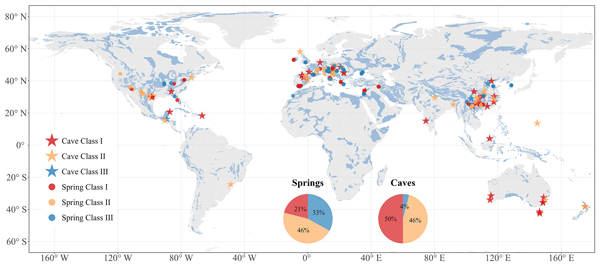
Yining Zang, Pauline C. Treble, Kei Yoshimura, Jayson Gabriel Pinza, Fengbo Zhang, Kübra Özdemir Çallı, Xiaojun Mei, Admin Husic, Alena Gessert, Andrej Stroj, Bartolomé Andreo, Bernard Ladouche, Christine Stumpp, Diana Mance, Eleni Zagana, Fen Huang, Giuseppe Sappa, Harald Kunstmann, Heike Brielmann, Hong Zhou, Huaying Wu, Jakob Garvelmann, James Berglund, Jean-Baptiste Charlier, Jens Lange, Juan Antonio Barberá Fornell, Junbing Pu, Konstantina Katsanou, Kun Ren, Laura Toran, Laurence Gill, Maria Filippini, Martin Kralik, Matías Mudarra Martínez, Min Zhao, Mingming Luo, Nico Goldscheider, Nikolaos Lambrakis, Pantaleone De Vita, Qiong Xiao, Shi Yu, Silvia Iacurto, Silvio Coda, Ted McCormack, Vincenzo Allocca, W. George Darling, Walter D'Alessandro, Xulei Guo, Yundi Hu, Zhijun Wang, Eva Kaminsky, Jiří Faimon, Marek Lang, Pavel Pracný, Aurel Persoiu, and Andreas Hartmann
Earth Syst. Sci. Data, 18, 7199–7225, https://doi.org/10.5194/essd-18-7199-2026, https://doi.org/10.5194/essd-18-7199-2026, 2026
Short summary
Short summary
We developed the first global database of water from karst springs and cave drips that records different forms of oxygen and hydrogen, which naturally trace how rainwater moves through rocks. By gathering and checking thousands of measurements from around the globe and linking them with flow and rainfall data, the database provides a comprehensive view of water movement, allows scientists to compare regions, understand groundwater processes, and support sustainable water management worldwide.
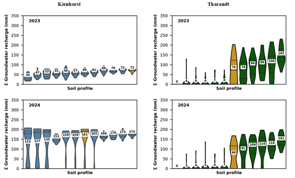
Thomas Fichtner, Yuly Juliana Aguilar Avila, Katja Ehrenberg, Stefan Seeger, Martin Maier, Stephan Raspe, and Andreas Hartmann
Hydrol. Earth Syst. Sci., 30, 5711–5734, https://doi.org/10.5194/hess-30-5711-2026, https://doi.org/10.5194/hess-30-5711-2026, 2026
Short summary
Short summary
The study examines how spatial soil moisture variability affects Soil-Vegetation-Atmosphere Transfer (SVAT) model calibration and groundwater recharge estimates in forest ecosystems. It is demonstrated that model-inherent uncertainties outweight the influence of soil moisture variability. The results indicate that reliable groundwater recharge can be achieved using data from three to eleven profiles, offering practical guidance for efficient monitoring and calibration.
Tamara Leins, Nikolai Späth, Jan Seibert, Francesca Pianosi, Christian Reinhardt-Imjela, and Andreas Hartmann
EGUsphere, https://doi.org/10.5194/egusphere-2026-4470, https://doi.org/10.5194/egusphere-2026-4470, 2026
Short summary
Short summary
In this study, we found large uncertainties in the simulation of Subsurface Stormflow (SSF) in a lumped hydrological model using only discharge data for parameter estimation. High-flow-based parameter estimation could extract some additional information, but SSF-specific data remain necessary to achieve more realistic SSF simulations. Occurrence uncertainty dominated total SSF uncertainty, suggesting proxy data on SSF occurrence could already substantially reduce SSF simulation uncertainties.
Pauline C. Treble, Yining Zang, Nikita Kaushal, István G. Hatvani, Péter Tanos, Zoltan Kern, Andy Baker, Andreas Hartmann, Franziska A. Lechleitner, Bryce Belanger, Bruna Daudt de Oliveira, Will Sinclair, Dana F. C. Riechelmann, András Hidas, Kei Yoshimura, Laia Comas-Bru, and the SISAL working group members
Earth Syst. Sci. Data Discuss., https://doi.org/10.5194/essd-2026-31, https://doi.org/10.5194/essd-2026-31, 2026
Revised manuscript accepted for ESSD
Short summary
Short summary
Water dripping from cave ceilings is studied to understand how water moves from the surface to the cave. This has applications for palaeoclimate, groundwater and cave conservation studies. We present a new database containing water isotope measurements for drip water and rainfall at 75 cave locations globally. The database is a SISAL working group initiative (Speleothem Isotopes Synthesis and AnaLysis) and complements cave speleothem databases previously constructed by SISAL.
Süleyman Selim Çallı, Kübra Özdemir Çallı, Brahim Akdim, Bruno Arfib, Aleksey Benderev, Sandra Beranger, Avi Burg, Onur Can, Jean-Baptiste Charlier, Mehmet Çelik, Arda Melih Çetin, Fehdi Chemseddine, Miroslava Deliyska, Lucio Di Matteo, Marco Dionigi, Romeo Eftimi, Jutta Eybl, Davide Fronzi, Nico Goldscheider, Ergin Gökkaya, Jorge Jodar, Herve Jourde, Eva Kaminsky, Konstantina Katsanou, Alireza Kavousi, Melike Kaya, David Labat, Tanja Liesch, Peter Malik, Christian Massari, Cyril Mayaud, Naomi Mazzilli, Pavel Pracny, Natasa Ravbar, Nathan Rispal, Simon Seelig, Vianney Sivelle, Marc Steinmann, Daniela Valigi, Gerfried Winkler, Ahmet Kemal Yahşi, and Andreas Hartmann
Earth Syst. Sci. Data Discuss., https://doi.org/10.5194/essd-2026-281, https://doi.org/10.5194/essd-2026-281, 2026
Revised manuscript accepted for ESSD
Short summary
Short summary
Karst groundwater systems are vital but highly sensitive to climate change. Their complex underground flow makes them hard to manage without good data, so we gathered 118 high-quality records of spring discharge across Mediterranean mountain ranges. With an average of 19 years of data – including one nearly century-long record – this collection provides the detailed information needed to better predict water availability and protect these vulnerable groundwater sources.
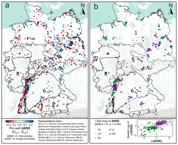
Marc Ohmer and Tanja Liesch
Hydrol. Earth Syst. Sci., 30, 2373–2394, https://doi.org/10.5194/hess-30-2373-2026, https://doi.org/10.5194/hess-30-2373-2026, 2026
Short summary
Short summary
We compared global vs. local deep learning models for groundwater level prediction using ~3,000 wells across Germany. Unlike surface water, groundwater is complex and data-scarce. Results: global models show no systematic accuracy advantage over local ones. Data similarity matters more than quantity for better predictions. Successful groundwater modeling requires strategies tailored to these unique complexities, not just larger datasets.
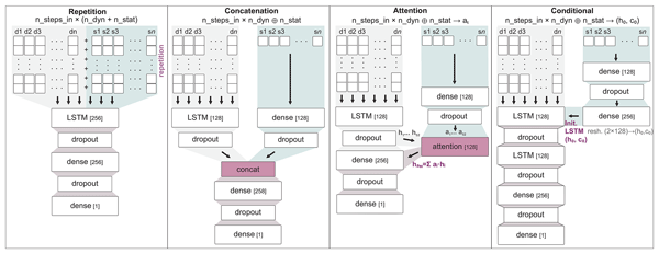
Tanja Liesch and Marc Ohmer
Hydrol. Earth Syst. Sci., 30, 1877–1890, https://doi.org/10.5194/hess-30-1877-2026, https://doi.org/10.5194/hess-30-1877-2026, 2026
Short summary
Short summary
We studied how to add site information to deep learning models that predict groundwater levels at many wells at once. Using data from Germany, we compared four simple ways to combine time varying weather with time invariant site characteristics. All methods gave similar average accuracy. Repeating site data at each time step was slightly best but used more computer power. The informativeness of site information mattered more than the method, guiding future model design.
Fabienne Doll, Tanja Liesch, Maria Wetzel, Stefan Kunz, and Stefan Broda
Geosci. Model Dev., 19, 2657–2675, https://doi.org/10.5194/gmd-19-2657-2026, https://doi.org/10.5194/gmd-19-2657-2026, 2026
Short summary
Short summary
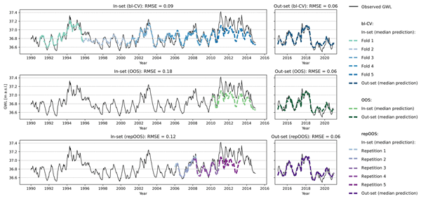
With the growing use of machine learning for groundwater level (GWL) prediction, proper performance estimation is crucial. This study compares three validation strategies—blocked cross-validation (bl-CV), repeated out-of-sample (repOOS), and out-of-sample (OOS)—for 1D-CNN and LSTM models using meteorological inputs. Results show that bl-CV offers the most reliable performance estimates, while OOS is the most uncertain, highlighting the need for careful method selection.
Robert Reinecke, Tanjila Akhter, Annemarie Bäthge, Ricarda Dietrich, Sebastian Gnann, Simon N. Gosling, Danielle Grogan, Andreas Hartmann, Stefan Kollet, Rohini Kumar, Richard Lammers, Sida Liu, Yan Liu, Nils Moosdorf, Bibi Naz, Sara Nazari, Chibuike Orazulike, Yadu Pokhrel, Jacob Schewe, Mikhail Smilovic, Maryna Strokal, Wim Thiery, Yoshihide Wada, Shan Zuidema, and Inge de Graaf
Geosci. Model Dev., 19, 523–542, https://doi.org/10.5194/gmd-19-523-2026, https://doi.org/10.5194/gmd-19-523-2026, 2026
Short summary
Short summary
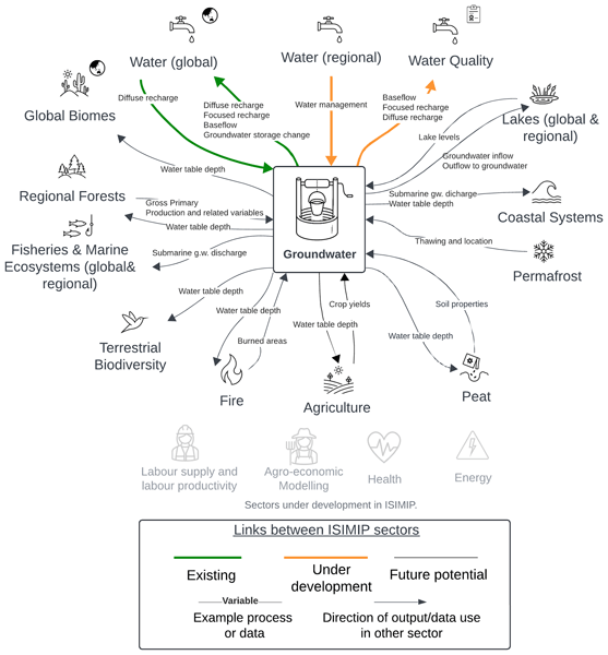
Here we describe a collaborative effort to improve predictions of how climate change will affect groundwater. The ISIMIP (The Inter-Sectoral Impact Model Intercomparison Project) groundwater sector combines multiple global groundwater models to capture a range of possible outcomes and reduce uncertainty. Initial comparisons reveal significant differences between models in key metrics like water table depth and recharge rates, highlighting the need for structured model intercomparisons.
Marc Ohmer, Tanja Liesch, Bastian Habbel, Benedikt Heudorfer, Mariana Gomez, Patrick Clos, Maximilian Nölscher, and Stefan Broda
Earth Syst. Sci. Data, 18, 77–95, https://doi.org/10.5194/essd-18-77-2026, https://doi.org/10.5194/essd-18-77-2026, 2026
Short summary
Short summary
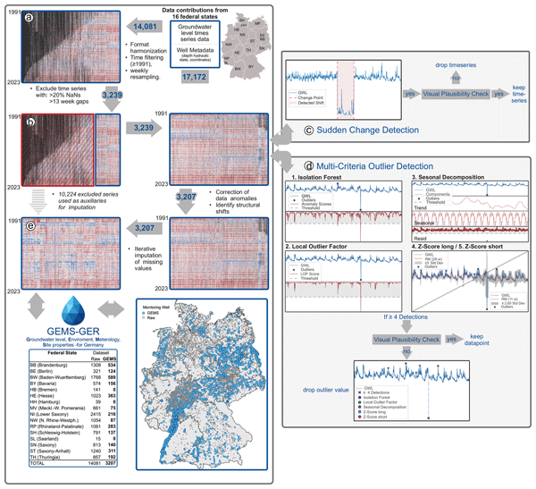
We present a public dataset of weekly groundwater levels from more than 3000 wells across Germany, spanning 32 years. It combines weather data and site-specific environmental information to support forecasting groundwater changes. Three benchmark models of varying complexity show how data and modeling approaches influence predictions. This resource promotes open, reproducible research and helps guide future water management decisions.
Theresa Blume, Peter Chifflard, Stefan Achleitner, Andreas Hartmann, Stefan Hergarten, Luisa Hopp, Bernhard Kohl, Florian Leese, Ilja van Meerveld, Christian Reinhardt-Imjela, and Markus Weiler
EGUsphere, https://doi.org/10.5194/egusphere-2025-4424, https://doi.org/10.5194/egusphere-2025-4424, 2025
Short summary
Short summary
Subsurface stormflow (SSF) is one of the least studied and therefore least understood runoff generation processes because detecting and quantifying SSF is extremely challenging. We present an ongoing concerted experimental effort to systematically investigate SSF across four catchments using a variety of methods covering different spatial scales. Centerpiece of this effort is the construction of 12 large trenches to capture and monitor SSF.
Stefan Kunz, Alexander Schulz, Maria Wetzel, Maximilian Nölscher, Teodor Chiaburu, Felix Biessmann, and Stefan Broda
Hydrol. Earth Syst. Sci., 29, 3405–3433, https://doi.org/10.5194/hess-29-3405-2025, https://doi.org/10.5194/hess-29-3405-2025, 2025
Short summary
Short summary
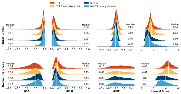
Accurate groundwater level predictions are crucial for sustainable management. This study applies two machine learning models – Neural Hierarchical Interpolation for Time Series Forecasting (N-HiTS) and the Temporal Fusion Transformer (TFT) – to forecast seasonal groundwater levels for 5288 wells across Germany. N-HiTS outperformed TFT, with both models performing well in diverse hydrogeological settings, particularly in lowlands with distinct seasonal dynamics.
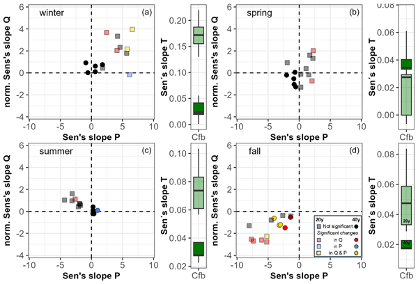
Markus Giese, Yvan Caballero, Andreas Hartmann, and Jean-Baptiste Charlier
Hydrol. Earth Syst. Sci., 29, 3037–3054, https://doi.org/10.5194/hess-29-3037-2025, https://doi.org/10.5194/hess-29-3037-2025, 2025
Short summary
Short summary
Karst springs respond quickly to environmental changes, making them crucial to understanding climate impacts on groundwater. This study analyses long-term trends in precipitation, temperature, and discharge from more than 50 springs across Europe. Results show that while historical discharge trends align with those of rivers, recent changes are driven by rising temperatures rather than precipitation. These findings highlight climate-driven shifts in groundwater recharge and storage processes.
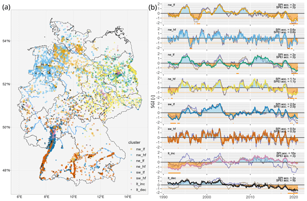
Pia Ebeling, Andreas Musolff, Rohini Kumar, Andreas Hartmann, and Jan H. Fleckenstein
Hydrol. Earth Syst. Sci., 29, 2925–2950, https://doi.org/10.5194/hess-29-2925-2025, https://doi.org/10.5194/hess-29-2925-2025, 2025
Short summary
Short summary
Groundwater is a crucial resource at risk due to droughts. To understand drought effects on groundwater levels in Germany, we grouped 6626 wells into six regional and two national patterns. Weather explained half of the level variations with varied response times. Shallow groundwater responds fast and is more vulnerable to short droughts (a few months). Dampened deep heads buffer short droughts but suffer from long droughts and recoveries. Two nationwide trend patterns were linked to human water use.
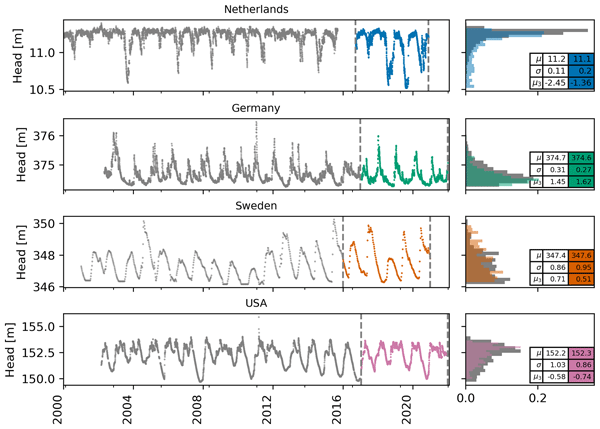
Raoul A. Collenteur, Ezra Haaf, Mark Bakker, Tanja Liesch, Andreas Wunsch, Jenny Soonthornrangsan, Jeremy White, Nick Martin, Rui Hugman, Ed de Sousa, Didier Vanden Berghe, Xinyang Fan, Tim J. Peterson, Jānis Bikše, Antoine Di Ciacca, Xinyue Wang, Yang Zheng, Maximilian Nölscher, Julian Koch, Raphael Schneider, Nikolas Benavides Höglund, Sivarama Krishna Reddy Chidepudi, Abel Henriot, Nicolas Massei, Abderrahim Jardani, Max Gustav Rudolph, Amir Rouhani, J. Jaime Gómez-Hernández, Seifeddine Jomaa, Anna Pölz, Tim Franken, Morteza Behbooei, Jimmy Lin, and Rojin Meysami
Hydrol. Earth Syst. Sci., 28, 5193–5208, https://doi.org/10.5194/hess-28-5193-2024, https://doi.org/10.5194/hess-28-5193-2024, 2024
Short summary
Short summary
We show the results of the 2022 Groundwater Time Series Modelling Challenge; 15 teams applied data-driven models to simulate hydraulic heads, and three model groups were identified: lumped, machine learning, and deep learning. For all wells, reasonable performance was obtained by at least one team from each group. There was not one team that performed best for all wells. In conclusion, the challenge was a successful initiative to compare different models and learn from each other.
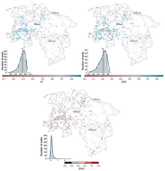
Mariana Gomez, Maximilian Nölscher, Andreas Hartmann, and Stefan Broda
Hydrol. Earth Syst. Sci., 28, 4407–4425, https://doi.org/10.5194/hess-28-4407-2024, https://doi.org/10.5194/hess-28-4407-2024, 2024
Short summary
Short summary
To understand the impact of external factors on groundwater level modelling using a 1-D convolutional neural network (CNN) model, we train, validate, and tune individual CNN models for 505 wells distributed across Lower Saxony, Germany. We then evaluate the performance of these models against available geospatial and time series features. This study provides new insights into the relationship between these factors and the accuracy of groundwater modelling.
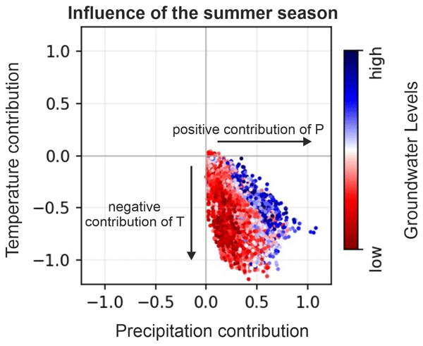
Andreas Wunsch, Tanja Liesch, and Nico Goldscheider
Hydrol. Earth Syst. Sci., 28, 2167–2178, https://doi.org/10.5194/hess-28-2167-2024, https://doi.org/10.5194/hess-28-2167-2024, 2024
Short summary
Short summary
Seasons have a strong influence on groundwater levels, but relationships are complex and partly unknown. Using data from wells in Germany and an explainable machine learning approach, we showed that summer precipitation is the key factor that controls the severeness of a low-water period in fall; high summer temperatures do not per se cause stronger decreases. Preceding winters have only a minor influence on such low-water periods in general.
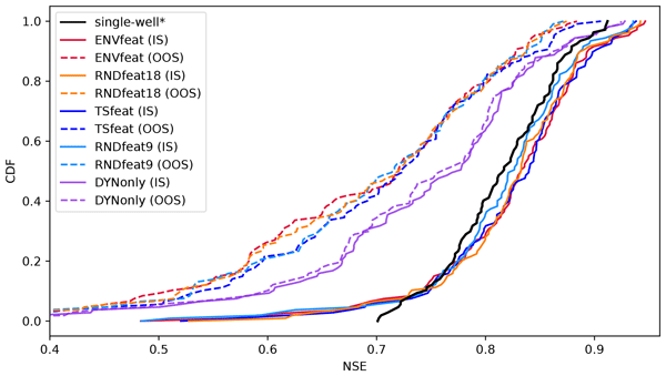
Benedikt Heudorfer, Tanja Liesch, and Stefan Broda
Hydrol. Earth Syst. Sci., 28, 525–543, https://doi.org/10.5194/hess-28-525-2024, https://doi.org/10.5194/hess-28-525-2024, 2024
Short summary
Short summary
We build a neural network to predict groundwater levels from monitoring wells. We predict all wells at the same time, by learning the differences between wells with static features, making it an entity-aware global model. This works, but we also test different static features and find that the model does not use them to learn exactly how the wells are different, but only to uniquely identify them. As this model class is not actually entity aware, we suggest further steps to make it so.
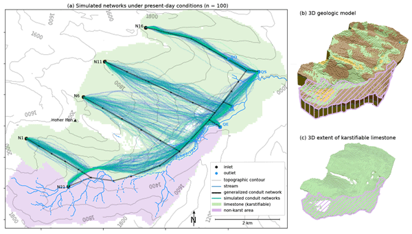
Chloé Fandel, Ty Ferré, François Miville, Philippe Renard, and Nico Goldscheider
Hydrol. Earth Syst. Sci., 27, 4205–4215, https://doi.org/10.5194/hess-27-4205-2023, https://doi.org/10.5194/hess-27-4205-2023, 2023
Short summary
Short summary
From the surface, it is hard to tell where underground cave systems are located. We developed a computer model to create maps of the probable cave network in an area, based on the geologic setting. We then applied our approach in reverse: in a region where an old cave network was mapped, we used modeling to test what the geologic setting might have been like when the caves formed. This is useful because understanding past cave formation can help us predict where unmapped caves are located today.
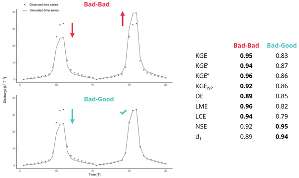
Guillaume Cinkus, Naomi Mazzilli, Hervé Jourde, Andreas Wunsch, Tanja Liesch, Nataša Ravbar, Zhao Chen, and Nico Goldscheider
Hydrol. Earth Syst. Sci., 27, 2397–2411, https://doi.org/10.5194/hess-27-2397-2023, https://doi.org/10.5194/hess-27-2397-2023, 2023
Short summary
Short summary
The Kling–Gupta Efficiency (KGE) is a performance criterion extensively used to evaluate hydrological models. We conduct a critical study on the KGE and its variant to examine counterbalancing errors. Results show that, when assessing a simulation, concurrent over- and underestimation of discharge can lead to an overall higher criterion score without an associated increase in model relevance. We suggest that one carefully choose performance criteria and use scaling factors.
Guillaume Cinkus, Andreas Wunsch, Naomi Mazzilli, Tanja Liesch, Zhao Chen, Nataša Ravbar, Joanna Doummar, Jaime Fernández-Ortega, Juan Antonio Barberá, Bartolomé Andreo, Nico Goldscheider, and Hervé Jourde
Hydrol. Earth Syst. Sci., 27, 1961–1985, https://doi.org/10.5194/hess-27-1961-2023, https://doi.org/10.5194/hess-27-1961-2023, 2023
Short summary
Short summary
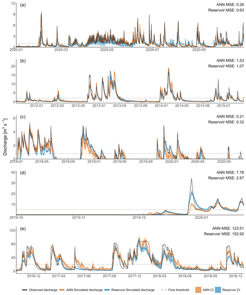
Numerous modelling approaches can be used for studying karst water resources, which can make it difficult for a stakeholder or researcher to choose the appropriate method. We conduct a comparison of two widely used karst modelling approaches: artificial neural networks (ANNs) and reservoir models. Results show that ANN models are very flexible and seem great for reproducing high flows. Reservoir models can work with relatively short time series and seem to accurately reproduce low flows.
Andreas Hartmann, Jean-Lionel Payeur-Poirier, and Luisa Hopp
Hydrol. Earth Syst. Sci., 27, 1325–1341, https://doi.org/10.5194/hess-27-1325-2023, https://doi.org/10.5194/hess-27-1325-2023, 2023
Short summary
Short summary
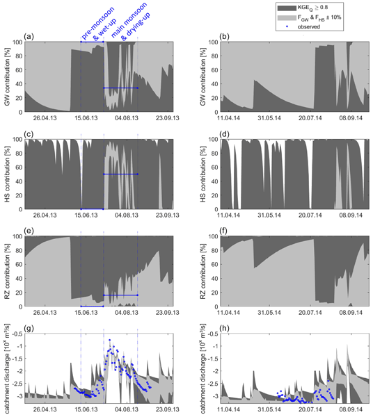
We advance our understanding of including information derived from environmental tracers into hydrological modeling. We present a simple approach that integrates streamflow observations and tracer-derived streamflow contributions for model parameter estimation. We consider multiple observed streamflow components and their variation over time to quantify the impact of their inclusion for streamflow prediction at the catchment scale.
Romane Berthelin, Tunde Olarinoye, Michael Rinderer, Matías Mudarra, Dominic Demand, Mirjam Scheller, and Andreas Hartmann
Hydrol. Earth Syst. Sci., 27, 385–400, https://doi.org/10.5194/hess-27-385-2023, https://doi.org/10.5194/hess-27-385-2023, 2023
Short summary
Short summary
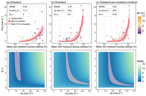
Karstic recharge processes have mainly been explored using discharge analysis despite the high influence of the heterogeneous surface on hydrological processes. In this paper, we introduce an event-based method which allows for recharge estimation from soil moisture measurements. The method was tested at a karst catchment in Germany but can be applied to other karst areas with precipitation and soil moisture data available. It will allow for a better characterization of karst recharge processes.
Tunde Olarinoye, Tom Gleeson, and Andreas Hartmann
Hydrol. Earth Syst. Sci., 26, 5431–5447, https://doi.org/10.5194/hess-26-5431-2022, https://doi.org/10.5194/hess-26-5431-2022, 2022
Short summary
Short summary
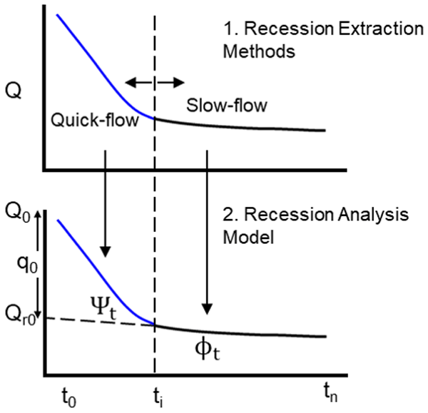
Analysis of karst spring recession is essential for management of groundwater. In karst, recession is dominated by slow and fast components; separating these components is by manual and subjective approaches. In our study, we tested the applicability of automated streamflow recession extraction procedures for a karst spring. Results showed that, by simple modification, streamflow extraction methods can identify slow and fast components: derived recession parameters are within reasonable ranges.
Yan Liu, Jaime Fernández-Ortega, Matías Mudarra, and Andreas Hartmann
Hydrol. Earth Syst. Sci., 26, 5341–5355, https://doi.org/10.5194/hess-26-5341-2022, https://doi.org/10.5194/hess-26-5341-2022, 2022
Short summary
Short summary
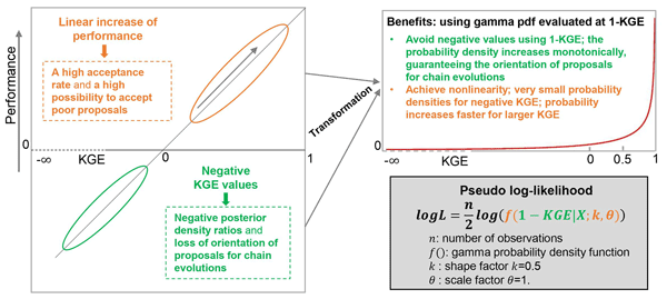
We adapt the informal Kling–Gupta efficiency (KGE) with a gamma distribution to apply it as an informal likelihood function in the DiffeRential Evolution Adaptive Metropolis DREAM(ZS) method. Our adapted approach performs as well as the formal likelihood function for exploring posterior distributions of model parameters. The adapted KGE is superior to the formal likelihood function for calibrations combining multiple observations with different lengths, frequencies and units.
Marc Ohmer, Tanja Liesch, and Andreas Wunsch
Hydrol. Earth Syst. Sci., 26, 4033–4053, https://doi.org/10.5194/hess-26-4033-2022, https://doi.org/10.5194/hess-26-4033-2022, 2022
Short summary
Short summary
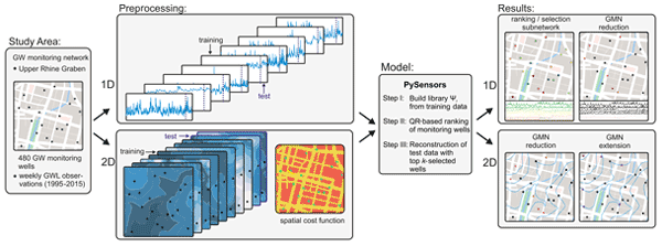
We present a data-driven approach to select optimal locations for groundwater monitoring wells. The applied approach can optimize the number of wells and their location for a network reduction (by ranking wells in order of their information content and reducing redundant) and extension (finding sites with great information gain) or both. It allows us to include a cost function to account for more/less suitable areas for new wells and can help to obtain maximum information content for a budget.
Andreas Wunsch, Tanja Liesch, Guillaume Cinkus, Nataša Ravbar, Zhao Chen, Naomi Mazzilli, Hervé Jourde, and Nico Goldscheider
Hydrol. Earth Syst. Sci., 26, 2405–2430, https://doi.org/10.5194/hess-26-2405-2022, https://doi.org/10.5194/hess-26-2405-2022, 2022
Short summary
Short summary
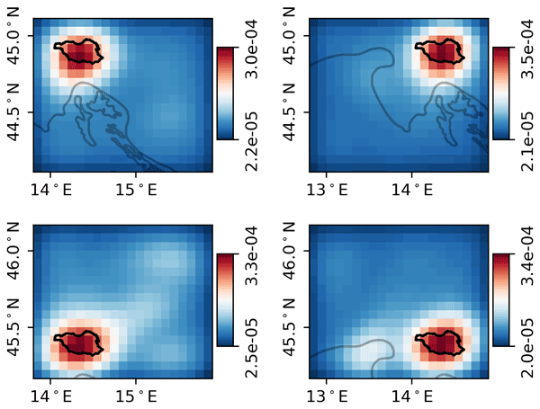
Modeling complex karst water resources is difficult enough, but often there are no or too few climate stations available within or close to the catchment to deliver input data for modeling purposes. We apply image recognition algorithms to time-distributed, spatially gridded meteorological data to simulate karst spring discharge. Our models can also learn the approximate catchment location of a spring independently.
Yong Chang, Benjamin Mewes, and Andreas Hartmann
Hydrol. Earth Syst. Sci. Discuss., https://doi.org/10.5194/hess-2022-77, https://doi.org/10.5194/hess-2022-77, 2022
Preprint withdrawn
Short summary
Short summary
This study presents a work to investigate the feasibility of using EC to predict the discharge in a typical karst catchment. We found that the spring discharge can be well predicted by EC in storms using LSTM (Long Short Term Memory) model, while the prediction has relatively large uncertainties in small recharge events. To establish a roust LSTM model for long-term discharge prediction from EC in ungauged catchments, the random or fixed-interval discharge monitoring strategy is recommended.
Tom Gleeson, Thorsten Wagener, Petra Döll, Samuel C. Zipper, Charles West, Yoshihide Wada, Richard Taylor, Bridget Scanlon, Rafael Rosolem, Shams Rahman, Nurudeen Oshinlaja, Reed Maxwell, Min-Hui Lo, Hyungjun Kim, Mary Hill, Andreas Hartmann, Graham Fogg, James S. Famiglietti, Agnès Ducharne, Inge de Graaf, Mark Cuthbert, Laura Condon, Etienne Bresciani, and Marc F. P. Bierkens
Geosci. Model Dev., 14, 7545–7571, https://doi.org/10.5194/gmd-14-7545-2021, https://doi.org/10.5194/gmd-14-7545-2021, 2021
Short summary
Short summary
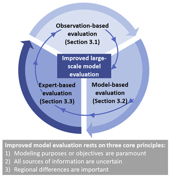
Groundwater is increasingly being included in large-scale (continental to global) land surface and hydrologic simulations. However, it is challenging to evaluate these simulations because groundwater is
hiddenunderground and thus hard to measure. We suggest using multiple complementary strategies to assess the performance of a model (
model evaluation).
Cited articles
Addor, N., Newman, A. J., Mizukami, N., and Clark, M. P.: The CAMELS data set: catchment attributes and meteorology for large-sample studies, Hydrol. Earth Syst. Sci., 21, 5293–5313, https://doi.org/10.5194/hess-21-5293-2017, 2017. a, b, c, d
Amatulli, G., Domisch, S., Tuanmu, M.-N., Parmentier, B., Ranipeta, A., Malczyk, J., and Jetz, W.: A suite of global, cross-scale topographic variables for environmental and biodiversity modeling, Sci. Data, 5, 180040, https://doi.org/10.1038/sdata.2018.40, 2018. a
Bailly-Comte, V., Ladouche, B., Charlier, J. B., Hakoun, V., and Maréchal, J. C.: XLKarst, an Excel tool for time series analysis, spring recession curve analysis and classification of karst aquifers, Hydrogeol. J., 31, 2401–2415, https://doi.org/10.1007/s10040-023-02710-w, 2023. a, b
Barthel, R., Haaf, E., Nygren, M., and Giese, M.: Systematic visual analysis of groundwater hydrographs: potential benefits and challenges, Hydrogeol. J., 30, 359–378, https://doi.org/10.1007/s10040-021-02433-w, 2022. a
Baston, D.: exactextractr: Fast Extraction from Raster Datasets using Polygons, version 0.10.1, CRAN [code], https://doi.org/10.32614/CRAN.package.exactextractr, 2025. a
Baudement, C., Arfib, B., Mazzilli, N., Jouves, J., Lamarque, T., and Guglielmi, Y.: Groundwater management of a highly dynamic karst by assessing baseflow and quickflow with a rainfall-discharge model (Dardennes springs, SE France), B. Soc. Géol. Fr., 188, 40, https://doi.org/10.1051/bsgf/2017203, 2017. a, b
Beck, H. E., McVicar, T. R., Vergopolan, N., Berg, A., Lutsko, N. J., Dufour, A., Zeng, Z., Jiang, X., Van Dijk, A. I. J. M., and Miralles, D. G.: High-resolution (1 km) Köppen-Geiger maps for 1901–2099 based on constrained CMIP6 projections, Sci. Data, 10, 724, https://doi.org/10.1038/s41597-023-02549-6, 2023. a, b
Beniston, M., Farinotti, D., Stoffel, M., Andreassen, L. M., Coppola, E., Eckert, N., Fantini, A., Giacona, F., Hauck, C., Huss, M., Huwald, H., Lehning, M., López-Moreno, J.-I., Magnusson, J., Marty, C., Morán-Tejéda, E., Morin, S., Naaim, M., Provenzale, A., Rabatel, A., Six, D., Stötter, J., Strasser, U., Terzago, S., and Vincent, C.: The European mountain cryosphere: a review of its current state, trends, and future challenges, The Cryosphere, 12, 759–794, https://doi.org/10.5194/tc-12-759-2018, 2018. a
Bittner, D., Narany, T. S., Kohl, B., Disse, M., and Chiogna, G.: Modeling the hydrological impact of land use change in a dolomite-dominated karst system, J. Hydrol., 567, 267–279, https://doi.org/10.1016/j.jhydrol.2018.10.017, 2018. a, b
Bongiovanni, G., Matiu, M., Crespi, A., Napoli, A., Majone, B., and Zardi, D.: EEAR-Clim: a high-density observational dataset of daily precipitation and air temperature for the Extended European Alpine Region, Earth Syst. Sci. Data, 17, 1367–1391, https://doi.org/10.5194/essd-17-1367-2025, 2025. a, b, c
Çallı, S. S., Özdemir Çallı, K., Akdim, B., Arfib, B., Benderev, A., Beranger, S., Burg, A., Can, O., Charlier, J.-B., Çelik, M., Çetin, A. M., Chemseddine, F., Deliyska, M., Di Matteo, L., Dionigi, M., Eftimi, R., Eybl, J., Fronzi, D., Goldscheider, N., Gökkaya, E., Jodar, J., Jourde, H., Kaminsky, E., Katsanou, K., Kavousi, A., Kaya, M., Labat, D., Liesch, T., Malik, P., Massari, C., Mayaud, C., Mazzilli, N., Pracny, P., Ravbar, N., Rispal, N., Seelig, S., Sivelle, V., Steinmann, M., Valigi, D., Winkler, G., Yahşi, A. K., and Hartmann, A.: High-Resolution Karst Spring Discharge Datasets of the Euro-Mediterranean Mountain Regions, Earth Syst. Sci. Data Discuss. [preprint], https://doi.org/10.5194/essd-2026-281, in review, 2026. a
Charlier, J.-B., Desprats, J.-F., and Ladouche, B.: Appui au SCHAPI 2014 – Module 1: Rôle et contribution des eaux souterraines d'origine karstique dans les crues de la Loue à Chenecey-Buillon, Tech. Rep. BRGM/RP-63844-FR, BRGM, https://orisk-bfc.fr/telechargement/fichier/5173 (last access: 16 November 2026), 2014. a
Chen, Z., Auler, A. S., Bakalowicz, M., Drew, D., Griger, F., Hartmann, J., Jiang, G., Moosdorf, N., Richts, A., Stevanovic, Z., Veni, G., and Goldscheider, N.: The World Karst Aquifer Mapping project: concept, mapping procedure and map of Europe, Hydrogeol. J., 25, 771–785, https://doi.org/10.1007/s10040-016-1519-3, 2017. a, b
Chen, Z., Hartmann, A., Wagener, T., and Goldscheider, N.: Dynamics of water fluxes and storages in an Alpine karst catchment under current and potential future climate conditions, Hydrol. Earth Syst. Sci., 22, 3807–3823, https://doi.org/10.5194/hess-22-3807-2018, 2018. a
Cinkus, G., Mazzilli, N., and Jourde, H.: KarstID: an R Shiny application for the analysis of karst spring discharge time series and the classification of karst system hydrological functioning, Environ. Earth Sci., 82, 136, https://doi.org/10.1007/s12665-023-10830-5, 2023. a, b
Cinkus, G., Bondu, R., Aliouache, M., Jourde, H., Mazzilli, N., Arfib, B., Bailly-Comte, V., Batiot-Guilhe, C., Celle, H., Delbart, C., Fournier, M., Labat, D., Peyraube, N., Steinmann, M., Valdès-Lao, D., Baudement, C., Béranger, S., Binet, S., Boetsch, A., Brunet, P., Carrière, S. D., Chalikakis, K., Charlier, J.-B., Cousquer, Y., Défarge, C., Ducasse, J., Emblanch, C., Fabre, J., Fleury, P., Garin, T., Huon, J., Jardani, A., Johannet, A., Jouves, J., Jozja, N., Justy, L., Ladouche, B., Lamarque, T., Lastennet, R., Léonardi, V., Lobry, O., Lorette, G., Loup, C., Marchand, P., Manière, L., Maréchal, J.-C., Martin, L., Muller, R., Massei, N., Naessens, F., Ollivier, C., Probst, A., Seidel, J.-L., Serene, L., Sivelle, V., and Zappelli, A.: Comprehensive dataset of continuously monitored hydrodynamic and physico-chemical parameters in various karst systems, France, Sci. Data, https://doi.org/10.1038/s41597-026-07561-0, 2026. a
Clerc-Schwarzenbach, F., Selleri, G., Neri, M., Toth, E., van Meerveld, I., and Seibert, J.: Large-sample hydrology – a few camels or a whole caravan?, Hydrol. Earth Syst. Sci., 28, 4219–4237, https://doi.org/10.5194/hess-28-4219-2024, 2024. a
Cornes, R. C., Van Der Schrier, G., Van Den Besselaar, E. J. M., and Jones, P. D.: An Ensemble Version of the E-OBS Temperature and Precipitation Data Sets, J. Geophys. Res.-Atmos., 123, 9391–9409, https://doi.org/10.1029/2017JD028200, 2018. a, b, c, d
Coxon, G., Addor, N., Bloomfield, J. P., Freer, J., Fry, M., Hannaford, J., Howden, N. J. K., Lane, R., Lewis, M., Robinson, E. L., Wagener, T., and Woods, R.: CAMELS-GB: hydrometeorological time series and landscape attributes for 671 catchments in Great Britain, Earth Syst. Sci. Data, 12, 2459–2483, https://doi.org/10.5194/essd-12-2459-2020, 2020. a
Delaigue, O., Guimarães, G. M., Brigode, P., Génot, B., Perrin, C., Soubeyroux, J.-M., Janet, B., Addor, N., and Andréassian, V.: CAMELS-FR dataset: a large-sample hydroclimatic dataset for France to explore hydrological diversity and support model benchmarking, Earth Syst. Sci. Data, 17, 1461–1479, https://doi.org/10.5194/essd-17-1461-2025, 2025. a
Do Nascimento, T. V. M., Höge, M., Schönenberger, U., Pool, S., Siber, R., Kauzlaric, M., Staudinger, M., Horton, P., Floriancic, M. G., Storck, F. R., Rinta, P., Seibert, J., and Fenicia, F.: Swiss data quality: augmenting CAMELS-CH with isotopes, water quality, agricultural and atmospheric data, Sci. Data, 12, 1283, https://doi.org/10.1038/s41597-025-05625-1, 2025. a
Donnini, M., Melelli, L., Vetuschi Zuccolini, M., Fiorucci, F., Cardellini, C., and Frondini, F.: ARETA (Alpine caRbon cyclE daTAset): a dataset on physical, chemical and isotopic data of Alpine groundwaters, Sci. Data, 13, 734, https://doi.org/10.1038/s41597-025-06541-0, 2026. a
DREAL Bourgogne Franche-Comté: Traçages des eaux souterraines en Bourgogne-Franche-Comté: circulation identifiée, https://www.data.gouv.fr/datasets/tracages-des-eaux-souterraines-en-bourgogne-franche-comte-circulation-identifiee (last access: 2 January 2026), 2020. a
Ebeling, P., Hubig, A., Wachholz, A., Scharfenberger, U., Haug, S., Nguyen, T., Sarrazin, F., Batool, M., Musolff, A., and Kumar, R.: QUADICA v2: extending the large-sample data set for water QUAlity, DIscharge and Catchment Attributes in Germany, Earth Syst. Sci. Data, 18, 691–712, https://doi.org/10.5194/essd-18-691-2026, 2026. a
EEA: EU-Hydro River Network Database 2006–2012 (vector), Europe – version 1.3, Nov. 2020, European Environment Agency (EEA) [data set], https://doi.org/10.2909/393359A7-7EBD-4A52-80AC-1A18D5F3DB9C, 2019. a, b
EEA: CORINE Land Cover 2018 (vector) – version 2020_20u1, European Environment Agency (EEA) [data set], https://doi.org/10.2909/71C95A07-E296-44FC-B22B-415F42ACFDF0, 2020. a, b
Epting, J., Page, R. M., Auckenthaler, A., and Huggenberger, P.: Process-based monitoring and modeling of Karst springs – Linking intrinsic to specific vulnerability, Sci. Total Environ., 625, 403–415, https://doi.org/10.1016/j.scitotenv.2017.12.272, 2018. a, b
ESA: Copernicus GLO-30 DEM – version 2023_1, European Space Agency (ESA) [data set], https://doi.org/10.5270/ESA-c5d3d65, 2023. a, b, c, d
Eurac Research and Permanent Secretariat of the Alpine Convention: Alpine Convention perimeter, Permanent Secretariat of the Alpine Convention [data set], https://doi.org/10.48784/VK93-8P54, 2025. a, b, c, d
Flora, S. P.: Hydrogeological characterization and discharge variability of springs in the Middle Verde River watershed, Central Arizona, Master's thesis, Northern Arizona University, https://in.nau.edu/wp-content/uploads/sites/55/2018/09/Flora_Thesis_2004-ek.pdf (last access: 16 November 2026), 2004. a, b
Ford, D. and Williams, P.: Analysis of Karst Drainage Systems, in: Karst Hydrogeology and Geomorphology, 145–208, John Wiley & Sons, Ltd, ISBN 978-1-118-68498-6, https://doi.org/10.1002/9781118684986.ch6, 2007. a
GeoSphere Austria: SPARTACUS v2.1 Tagesdaten, GeoSphere Austria [data set], https://doi.org/10.60669/M6W8-S545, 2020. a, b, c
Goldscheider, N. and Drew, D. (Eds.): Methods in karst hydrogeology, vol. 26 of International contributions to hydrogeology, Taylor and Francis, ISBN 978-0-415-42873-6, https://doi.org/10.1201/9781482266023, 2007. a
Goldscheider, N., Meiman, J., Pronk, M., and Smart, C.: Tracer tests in karst hydrogeology and speleology, Int. J. Speleol., 37, 27–40, https://doi.org/10.5038/1827-806X.37.1.3, 2008. a
Goldscheider, N., Chen, Z., Auler, A. S., Bakalowicz, M., Broda, S., Drew, D., Hartmann, J., Jiang, G., Moosdorf, N., Stevanovic, Z., and Veni, G.: Global distribution of carbonate rocks and karst water resources, Hydrogeol. J., 28, 1661–1677, https://doi.org/10.1007/s10040-020-02139-5, 2020. a
Goldscheider, N., Xanke, J., and Liesch, T.: Verbreitung von Carbonatgesteinen und Karstwasserressourcen im Alpenraum, Grundwasser, 30, 211–226, https://doi.org/10.1007/s00767-025-00596-x, 2025. a, b
Hengl, T., Mendes De Jesus, J., Heuvelink, G. B. M., Ruiperez Gonzalez, M., Kilibarda, M., Blagotić, A., Shangguan, W., Wright, M. N., Geng, X., Bauer-Marschallinger, B., Guevara, M. A., Vargas, R., MacMillan, R. A., Batjes, N. H., Leenaars, J. G. B., Ribeiro, E., Wheeler, I., Mantel, S., and Kempen, B.: SoilGrids250m: Global gridded soil information based on machine learning, PLOS ONE, 12, e0169748, https://doi.org/10.1371/journal.pone.0169748, 2017. a
Hiederer, R.: Mapping soil properties for Europe: spatial representation of soil database attributes, no. EUR26082EN in Scientific and Technical Research Series, Publications Office of the European Union, Luxembourg, ISBN 978-92-79-32516-8, https://doi.org/10.2788/94128, 2013a. a, b
Hiederer, R.: Mapping soil typologies: spatial decision support applied to the European Soil Database, no. EUR25932EN in Scientific and Technical Research Series, Publications Office of the European Union, Luxembourg, https://doi.org/10.2788/87286, 2013b. a, b
Höge, M., Kauzlaric, M., Siber, R., Schönenberger, U., Horton, P., Schwanbeck, J., Floriancic, M. G., Viviroli, D., Wilhelm, S., Sikorska-Senoner, A. E., Addor, N., Brunner, M., Pool, S., Zappa, M., and Fenicia, F.: CAMELS-CH: hydro-meteorological time series and landscape attributes for 331 catchments in hydrologic Switzerland, Earth Syst. Sci. Data, 15, 5755–5784, https://doi.org/10.5194/essd-15-5755-2023, 2023. a, b, c
Horton, R. E.: Drainage‐basin characteristics, EOS T. Am. Geophys. Un., 13, 350–361, https://doi.org/10.1029/TR013i001p00350, 1932. a, b
Jeannin, P.-Y., Artigue, G., Butscher, C., Chang, Y., Charlier, J.-B., Duran, L., Gill, L., Hartmann, A., Johannet, A., Jourde, H., Kavousi, A., Liesch, T., Liu, Y., Lüthi, M., Malard, A., Mazzilli, N., Pardo-Igúzquiza, E., Thiéry, D., Reimann, T., Schuler, P., Wöhling, T., and Wunsch, A.: Karst modelling challenge 1: Results of hydrological modelling, J. Hydrol., 600, 126508, https://doi.org/10.1016/j.jhydrol.2021.126508, 2021. a, b
Jeannin, P.-Y., Malard, A., and Sinreich, M.: Advanced Approach to Assess Groundwater Storage and Water Availability in Karst Aquifers at Regional Scale, Hydrology, 13, 226, https://doi.org/10.3390/hydrology13090226, 2026. a, b, c
Joger, F. and Thinius, P.: FelixJoger/ALPAKAS: ALPAKAS Code Release v1.0, Zenodo [code], https://doi.org/10.5281/zenodo.24159191, 2026. a
Joger, F., Thinius, P., Chen, Z., Hartmann, A., Goldscheider, N., Liesch, T., Schubert, G., and Broda, S.: ALPAKAS: ALPine hydrographs and catchment Attributes for KArst Springs, Zenodo [data set], https://doi.org/10.5281/zenodo.23592639, 2026. a, b
Jones, E. R., Kratzert, F., and Van Vliet, M. T. H.: Caravan-Qual: A global scale integration of stream water quality observations into a large-sample hydrology dataset, Sci. Data, 13, 1015, https://doi.org/10.1038/s41597-026-07352-7, 2026. a
Killick, R. and Eckley, I. A.: changepoint: An R Package for Changepoint Analysis, J. Stat. Softw., 58, 1–27, https://doi.org/10.18637/jss.v058.i03, 2014. a, b
Klingler, C., Schulz, K., and Herrnegger, M.: LamaH-CE: LArge-SaMple DAta for Hydrology and Environmental Sciences for Central Europe, Earth Syst. Sci. Data, 13, 4529–4565, https://doi.org/10.5194/essd-13-4529-2021, 2021. a
Kotlarski, S., Gobiet, A., Morin, S., Olefs, M., Rajczak, J., and Samacoïts, R.: 21st Century alpine climate change, Clim. Dynam., 60, 65–86, https://doi.org/10.1007/s00382-022-06303-3, 2023. a
Kratzert, F., Klotz, D., Shalev, G., Klambauer, G., Hochreiter, S., and Nearing, G.: Towards learning universal, regional, and local hydrological behaviors via machine learning applied to large-sample datasets, Hydrol. Earth Syst. Sci., 23, 5089–5110, https://doi.org/10.5194/hess-23-5089-2019, 2019. a
Kratzert, F., Nearing, G., Addor, N., Erickson, T., Gauch, M., Gilon, O., Gudmundsson, L., Hassidim, A., Klotz, D., Nevo, S., Shalev, G., and Matias, Y.: Caravan – A global community dataset for large-sample hydrology, Sci. Data, 10, 61, https://doi.org/10.1038/s41597-023-01975-w, 2023. a
Lindsay, J. B.: Whitebox GAT: A case study in geomorphometric analysis, Comput. Geosci., 95, 75–84, https://doi.org/10.1016/j.cageo.2016.07.003, 2016. a
Linsbauer, A., Huss, M., Hodel, E., Bauder, A., Fischer, M., Weidmann, Y., Bärtschi, H., and Schmassmann, E.: The New Swiss Glacier Inventory SGI2016: From a Topographical to a Glaciological Dataset, Front. Earth Sci., 9, 704189, https://doi.org/10.3389/feart.2021.704189, 2021. a
Loritz, R., Dolich, A., Acuña Espinoza, E., Ebeling, P., Guse, B., Götte, J., Hassler, S. K., Hauffe, C., Heidbüchel, I., Kiesel, J., Mälicke, M., Müller-Thomy, H., Stölzle, M., and Tarasova, L.: CAMELS-DE: hydro-meteorological time series and attributes for 1582 catchments in Germany, Earth Syst. Sci. Data, 16, 5625–5642, https://doi.org/10.5194/essd-16-5625-2024, 2024. a
Mangin, A.: Pour une meilleure connaissance des systèmes hydrologiques à partir des analyses corrélatoire et spectrale, J. Hydrol., 67, 25–43, https://doi.org/10.1016/0022-1694(84)90230-0, 1984. a, b
Moraga, J. S., Peleg, N., Fatichi, S., Molnar, P., and Burlando, P.: Revealing the impacts of climate change on mountainous catchments through high-resolution modelling, J. Hydrol., 603, 126806, https://doi.org/10.1016/j.jhydrol.2021.126806, 2021. a
Muñoz Sabater, J.: ERA5-Land hourly data from 1950 to present, Copernicus Climate Change Service (C3S) Climate Data Store (CDS) [data set], https://doi.org/10.24381/CDS.E2161BAC, 2019a. a, b, c
Muñoz Sabater, J.: ERA5-Land monthly averaged data from 1950 to present, Copernicus Climate Change Service (C3S) Climate Data Store (CDS) [data set], https://doi.org/10.24381/cds.68d2bb30, 2019b. a
Nearing, G., Cohen, D., Dube, V., Gauch, M., Gilon, O., Harrigan, S., Hassidim, A., Klotz, D., Kratzert, F., Metzger, A., Nevo, S., Pappenberger, F., Prudhomme, C., Shalev, G., Shenzis, S., Tekalign, T. Y., Weitzner, D., and Matias, Y.: Global prediction of extreme floods in ungauged watersheds, Nature, 627, 559–563, https://doi.org/10.1038/s41586-024-07145-1, 2024. a
Newman, A. J., Clark, M. P., Sampson, K., Wood, A., Hay, L. E., Bock, A., Viger, R. J., Blodgett, D., Brekke, L., Arnold, J. R., Hopson, T., and Duan, Q.: Development of a large-sample watershed-scale hydrometeorological data set for the contiguous USA: data set characteristics and assessment of regional variability in hydrologic model performance, Hydrol. Earth Syst. Sci., 19, 209–223, https://doi.org/10.5194/hess-19-209-2015, 2015. a
Ohmer, M., Liesch, T., Habbel, B., Heudorfer, B., Gomez, M., Clos, P., Nölscher, M., and Broda, S.: GEMS-GER: a machine learning benchmark dataset of long-term groundwater levels in Germany with meteorological forcings and site-specific environmental features, Earth Syst. Sci. Data, 18, 77–95, https://doi.org/10.5194/essd-18-77-2026, 2026. a
Olarinoye, T., Gleeson, T., Marx, V., Seeger, S., Adinehvand, R., Allocca, V., Andreo, B., Apaéstegui, J., Apolit, C., Arfib, B., Auler, A., Bailly-Comte, V., Barberá, J. A., Batiot-Guilhe, C., Bechtel, T., Binet, S., Bittner, D., Blatnik, M., Bolger, T., Brunet, P., Charlier, J.-B., Chen, Z., Chiogna, G., Coxon, G., De Vita, P., Doummar, J., Epting, J., Fleury, P., Fournier, M., Goldscheider, N., Gunn, J., Guo, F., Guyot, J. L., Howden, N., Huggenberger, P., Hunt, B., Jeannin, P.-Y., Jiang, G., Jones, G., Jourde, H., Karmann, I., Koit, O., Kordilla, J., Labat, D., Ladouche, B., Liso, I. S., Liu, Z., Maréchal, J.-C., Massei, N., Mazzilli, N., Mudarra, M., Parise, M., Pu, J., Ravbar, N., Sanchez, L. H., Santo, A., Sauter, M., Seidel, J.-L., Sivelle, V., Skoglund, R. Ø., Stevanovic, Z., Wood, C., Worthington, S., and Hartmann, A.: Global karst springs hydrograph dataset for research and management of the world's fastest-flowing groundwater, Sci. Data, 7, 59, https://doi.org/10.1038/s41597-019-0346-5, 2020. a, b, c
Paul, F., Frey, H., and Le Bris, R.: A new glacier inventory for the European Alps from Landsat TM scenes of 2003: challenges and results, Ann. Glaciol., 52, 144–152, https://doi.org/10.3189/172756411799096295, 2011. a
Paul, F., Rastner, P., Azzoni, R. S., Diolaiuti, G., Fugazza, D., Le Bris, R., Nemec, J., Rabatel, A., Ramusovic, M., Schwaizer, G., and Smiraglia, C.: Glacier inventory of the Alps from Sentinel-2, shape files, PANGAEA [data set], https://doi.org/10.1594/PANGAEA.909133, 2019. a, b
Paul, F., Rastner, P., Azzoni, R. S., Diolaiuti, G., Fugazza, D., Le Bris, R., Nemec, J., Rabatel, A., Ramusovic, M., Schwaizer, G., and Smiraglia, C.: Glacier shrinkage in the Alps continues unabated as revealed by a new glacier inventory from Sentinel-2, Earth Syst. Sci. Data, 12, 1805–1821, https://doi.org/10.5194/essd-12-1805-2020, 2020. a
Pelletier, J., Broxton, P., Hazenberg, P., Zeng, X., Troch, P., Niu, G., Williams, Z., Brunke, M., and Gochis, D.: Global 1-km Gridded Thickness of Soil, Regolith, and Sedimentary Deposit Layers, ORNL Distributed Active Archive Center [data set], https://doi.org/10.3334/ORNLDAAC/1304, 2016. a, b
Reinthaler, J.: Reconstructed glacier area and volume changes in the European Alps since the Little Ice Age, Zenodo [data set], https://doi.org/10.5281/zenodo.14336827, 2024. a, b
RGI Consortium: Randolph Glacier Inventory – A Dataset of Global Glacier Outlines – version 7, National Snow and Ice Data Center [data set], https://doi.org/10.5067/F6JMOVY5NAVZ, 2023. a, b
Rubel, F., Brugger, K., Haslinger, K., and Auer, I.: The climate of the European Alps: Shift of very high resolution Köppen-Geiger climate zones 1800–2100, Meteorol. Z., 26, 115–125, https://doi.org/10.1127/metz/2016/0816, 2017. a
Rumpf, S. B., Gravey, M., Brönnimann, O., Luoto, M., Cianfrani, C., Mariethoz, G., and Guisan, A.: From white to green: Snow cover loss and increased vegetation productivity in the European Alps, Science, 376, 1119–1122, https://doi.org/10.1126/science.abn6697, 2022. a
Škrk, N., Luis, M. D., Čufar, K., Zalika Črepinšek, Lučka Kajfež Bogataj, and Serrano-Notivoli, R.: SLOCLIM: A high-resolution daily gridded precipitation and temperature dataset for Slovenia, Zenodo [data set], https://doi.org/10.5281/zenodo.4108543, 2020. a, b, c, d
SNO KARST: Time series of type hydrology-hydrogeology in Aire d'alimentation de l'hydrosystème d'Arcier basin – JURASSIC KARST observatory – KARST observatory network – OZCAR Critical Zone network Research Infrastructure, Service National d'Observation du KARST (SNO KARST) [data set], https://doi.org/10.15148/792C2468-D839-4AD3-8EF0-B928A6656E8C, 2025a. a, b, c
SNO KARST: Time series of type hydrology-hydrogeology in Loue-Lison basin – JURASSIC KARST observatory – KARST observatory network – OZCAR Critical Zone network Research Infrastructure, Service National d’Observation du KARST (SNO KARST) [data set], https://doi.org/10.15148/A2CA20F9-CD78-4260-84D4-CEB4B1426666, 2025b. a, b
SNO KARST: Time series of type hydrology-hydrogeology in Le Doubs basin – JURASSIC KARST observatory – KARST observatory network – OZCAR Critical Zone network Research Infrastructure, Service National d'Observation du KARST (SNO KARST) [data set], https://doi.org/10.15148/3B65D490-0AEB-4B30-84A5-C5D46CFA855B, 2025c. a, b
Somers, L. and McKenzie, J.: A review of groundwater in high mountain environments, WIREs Water, 7, https://doi.org/10.1002/wat2.1475, 2020. a
Sterle, G., Perdrial, J., Kincaid, D. W., Underwood, K. L., Rizzo, D. M., Haq, I. U., Li, L., Lee, B. S., Adler, T., Wen, H., Middleton, H., and Harpold, A. A.: CAMELS-Chem: augmenting CAMELS (Catchment Attributes and Meteorology for Large-sample Studies) with atmospheric and stream water chemistry data, Hydrol. Earth Syst. Sci., 28, 611–630, https://doi.org/10.5194/hess-28-611-2024, 2024. a
Stevanović, Z.: Initiative to Select, Label and Protect the World's Most Important Karst Springs, in: EuroKarst 2022, Málaga, edited by: Andreo, B., Barberá, J. A., Durán-Valsero, J. J., Gil-Márquez, J. M., and Mudarra, M., Advances in Karst Science, 3–7, Springer International Publishing, Cham, https://doi.org/10.1007/978-3-031-16879-6_1, 2023. a
Strohmenger, L., Sauquet, E., Bernard, C., Bonneau, J., Branger, F., Bresson, A., Brigode, P., Buzier, R., Delaigue, O., Devers, A., Evin, G., Fournier, M., Hsu, S.-C., Lanini, S., de Lavenne, A., Lemaitre-Basset, T., Magand, C., Mendoza Guimarães, G., Mentha, M., Munier, S., Perrin, C., Podechard, T., Rouchy, L., Sadki, M., Soutif-Bellenger, M., Tilmant, F., Tramblay, Y., Véron, A.-L., Vidal, J.-P., and Thirel, G.: On the visual detection of non-natural records in streamflow time series: challenges and impacts, Hydrol. Earth Syst. Sci., 27, 3375–3391, https://doi.org/10.5194/hess-27-3375-2023, 2023. a
Tissot, G. and Tresse, P.: Étude des systèmes karstiques du Lison et du Verneau, région de Nans-sous-Sainte-Anne (Doubs), PhD thesis, Université de Franche-Comté, Besançon, France, https://orisk-bfc.fr/document_karst/detail/93456 (last access: 16 November 2026), 1978. a
Tóth, B., Weynants, M., Pásztor, L., and Hengl, T.: 3D soil hydraulic database of Europe at 250 m resolution, Hydrol. Process., 31, 2662–2666, https://doi.org/10.1002/hyp.11203, 2017. a, b
Ushey, K. and Wickham, H.: renv: Project Environments, version 1.2.2, CRAN [code], https://doi.org/10.32614/CRAN.package.renv, 2026. a
van Tiel, M., Aubry-Wake, C., Somers, L., Andermann, C., Avanzi, F., Baraer, M., Chiogna, G., Daigre, C., Das, S., Drenkhan, F., Farinotti, D., Fyffe, C. L., de Graaf, I., Hanus, S., Immerzeel, W., Koch, F., McKenzie, J. M., Müller, T., Popp, A. L., Saidaliyeva, Z., Schaefli, B., Schilling, O. S., Teagai, K., Thornton, J. M., and Yapiyev, V.: Cryosphere–groundwater connectivity is a missing link in the mountain water cycle, Nature Water, 2, 624–637, https://doi.org/10.1038/s44221-024-00277-8, 2024. a
Vidal, J., Martin, E., Franchistéguy, L., Baillon, M., and Soubeyroux, J.: A 50‐year high‐resolution atmospheric reanalysis over France with the Safran system, Int. J. Climatol., 30, 1627–1644, https://doi.org/10.1002/joc.2003, 2010. a, b, c
Viviroli, D., Dürr, H. H., Messerli, B., Meybeck, M., and Weingartner, R.: Mountains of the world, water towers for humanity: Typology, mapping, and global significance, Water Resour. Res., 43, https://doi.org/10.1029/2006WR005653, 2007. a
Vremec, M., Seelig, M., Seelig, S., Collenteur, R., Haslinger, K., Wagner, T., Eybl, J., and Winkler, G.: Trend analysis of Alpine spring discharge: Interplay between climate and discharge characteristics, Sci. Total Environ., 993, 179875, https://doi.org/10.1016/j.scitotenv.2025.179875, 2025. a
Wagner, T., Themeßl, M., Schüppel, A., Gobiet, A., Stigler, H., and Birk, S.: Impacts of climate change on stream flow and hydro power generation in the Alpine region, Environ. Earth Sci., 76, 4, https://doi.org/10.1007/s12665-016-6318-6, 2017. a, b
Westerberg, I. K., Sikorska-Senoner, A. E., Viviroli, D., Vis, M., and Seibert, J.: Hydrological model calibration with uncertain discharge data, Hydrolog. Sci. J., 67, 2441–2456, https://doi.org/10.1080/02626667.2020.1735638, 2022. a
Wilby, R. L., Clifford, N. J., De Luca, P., Harrigan, S., Hillier, J. K., Hodgkins, R., Johnson, M. F., Matthews, T. K., Murphy, C., Noone, S. J., Parry, S., Prudhomme, C., Rice, S. P., Slater, L. J., Smith, K. A., and Wood, P. J.: The “dirty dozen” of freshwater science: detecting then reconciling hydrological data biases and errors, WIREs Water, 4, e1209, https://doi.org/10.1002/wat2.1209, 2017. a
Wilkinson, M. D., Dumontier, M., Aalbersberg, I. J., Appleton, G., Axton, M., Baak, A., Blomberg, N., Boiten, J.-W., Da Silva Santos, L. B., Bourne, P. E., Bouwman, J., Brookes, A. J., Clark, T., Crosas, M., Dillo, I., Dumon, O., Edmunds, S., Evelo, C. T., Finkers, R., Gonzalez-Beltran, A., Gray, A. J., Groth, P., Goble, C., Grethe, J. S., Heringa, J., 'T Hoen, P. A., Hooft, R., Kuhn, T., Kok, R., Kok, J., Lusher, S. J., Martone, M. E., Mons, A., Packer, A. L., Persson, B., Rocca-Serra, P., Roos, M., Van Schaik, R., Sansone, S.-A., Schultes, E., Sengstag, T., Slater, T., Strawn, G., Swertz, M. A., Thompson, M., Van Der Lei, J., Van Mulligen, E., Velterop, J., Waagmeester, A., Wittenburg, P., Wolstencroft, K., Zhao, J., and Mons, B.: The FAIR Guiding Principles for scientific data management and stewardship, Sci. Data, 3, 160018, https://doi.org/10.1038/sdata.2016.18, 2016. a, b
Wood, R. R., Janzing, J., van Hamel, A., Götte, J., Schumacher, D. L., and Brunner, M. I.: Comparison of high-resolution climate reanalysis datasets for hydro-climatic impact studies, Hydrol. Earth Syst. Sci., 29, 4153–4178, https://doi.org/10.5194/hess-29-4153-2025, 2025. a, b
Woods, R. A.: Analytical model of seasonal climate impacts on snow hydrology: Continuous snowpacks, Adv. Water Resour., 32, 1465–1481, https://doi.org/10.1016/j.advwatres.2009.06.011, 2009. a
Wu, Q. and Brown, A.: whitebox: “WhiteboxTools” R Frontend, version 2.4.3, CRAN [code], https://doi.org/10.32614/CRAN.package.whitebox, 2025. a
Xanke, J., Goldscheider, N., Michel, B., Barberá, J. A., Broda, S., Chen, Z., Ghanmi, M., Andreas, G., Hartmann, A., Jourde, H., Liesch, T., Matías, M., Petitta, M., Ravbar, N., and Stevanovic, Z.: Mediterranean Karst Aquifer Map 1 : 5,000,000 (MEDKAM), BGR, KIT, UNESCO [data set], https://doi.org/10.25928/MEDKAM.1, 2022. a, b, c, d, e
Zeileis, A. and Grothendieck, G.: zoo: S3 Infrastructure for Regular and Irregular Time Series, J. Stat. Softw., 14, 1–27, https://doi.org/10.18637/jss.v014.i06, 2005. a
Editorial statement
ALPAKAS is harmonized large-sample dataset of karst springs discharge and associated catchment attributes and meteorological forcing data in the Alpine region. The dataset covers different environmental zones, facilitating a variety of scientific applications, and contains a detailed uncertainty description, enabling an informed reuse. The topic of Karst springs also holds societal value due to the very seasonal nature of their discharge, especially in relation to climate change impacts. Both the data and code are well-documented and openly accessible.
ALPAKAS is harmonized large-sample dataset of karst springs discharge and associated catchment...
Short summary
Karst aquifers are important water sources in the Alps, but comparable spring discharge data have been lacking. We created ALPAKAS, the first large-sample benchmark dataset dedicated to karst springs across the wider Alpine region. It provides 242 daily and 182 hourly harmonized and quality-controlled discharge records, along with catchment delineations, meteorological time series, catchment attributes, and karst-specific indices. The dataset supports comparative analyses and model benchmarking.
Karst aquifers are important water sources in the Alps, but comparable spring discharge data...


Altmetrics
Final-revised paper
Preprint