Articles | Volume 18, issue 10
https://doi.org/10.5194/essd-18-7455-2026
© Author(s) 2026. This work is distributed under
the Creative Commons Attribution 4.0 License.
the Creative Commons Attribution 4.0 License.
https://doi.org/10.5194/essd-18-7455-2026
© Author(s) 2026. This work is distributed under
the Creative Commons Attribution 4.0 License.
the Creative Commons Attribution 4.0 License.
Data description article
| 
12 Oct 2026
Data description article |
| 12 Oct 2026
| 12 Oct 2026
The OpenSat4Weather dataset: Ku-band satellite link data for precipitation monitoring

Institute of Electronics, Computer and Telecommunication Engineering (IEIIT) of the National Research Council of Italy (CNR), Milan, Italy
Maximilian Graf
Department of Hydrometeorology, Deutscher Wetterdienst, Offenbach, Germany
Greta Cazzaniga
Laboratoire des Sciences du Climat et de l'Environnement, UMR 8212 CEA-CNRS-UVSQ, Université Paris-Saclay, IPSL, 91191 Gif-sur-Yvette, France
François Mercier
Sereno/HD Rain, 198 avenue de France, Paris, France
Maxime Turko
Sereno/HD Rain, 198 avenue de France, Paris, France
Related authors
Elia Covi, Giacomo Roversi, and Roberto Nebuloni
Earth Syst. Sci. Data Discuss., https://doi.org/10.5194/essd-2026-160, https://doi.org/10.5194/essd-2026-160, 2026
Revised manuscript accepted for ESSD
Short summary
Short summary
OpenRainER is an open-source dataset containing two years of precipitation measurements from the Emilia-Romagna region in Italy, collected using commercial microwave links, weather radars and rain gauges. OpenRainER aims to promote research on opportunistic sensors for rainfall monitoring. The regional context allows tackling challenges from complex orography, and the accompanying article describes the data to facilitate its use.
Greta Cazzaniga, Carlo De Michele, Michele D'Amico, Cristina Deidda, Antonio Ghezzi, and Roberto Nebuloni
Hydrol. Earth Syst. Sci., 26, 2093–2111, https://doi.org/10.5194/hess-26-2093-2022, https://doi.org/10.5194/hess-26-2093-2022, 2022
Short summary
Short summary
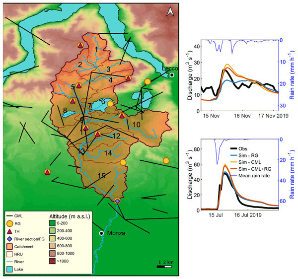
Rainfall estimates are usually obtained from rain gauges, weather radars, or satellites. An alternative is the measurement of the signal loss induced by rainfall on commercial microwave links (CMLs). In this work, we assess the hydrologic response of Lambro Basin when CML-retrieved rainfall is used as model input. CML estimates agree with rain gauge data. CML-driven discharge simulations show performance comparable to that from rain gauges if a CML-based calibration of the model is undertaken.
Greta Cazzaniga, Anastasia Akakpo-Numado, Patrick Brockmann, Adrien Burq, Mathieu Vrac, and Davide Faranda
Nat. Hazards Earth Syst. Sci., 26, 4741–4752, https://doi.org/10.5194/nhess-26-4741-2026, https://doi.org/10.5194/nhess-26-4741-2026, 2026
Short summary
Short summary
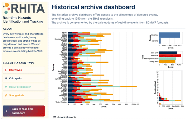
Extreme weather events are becoming more frequent and severe, creating a strong need for rapid and reliable information. We developed an open tool that automatically detects and tracks heatwaves, cold spells, heavy rain, and strong winds across Europe, both in real time and in past decades. By comparing current events with long historical records, the tool shows how unusual an event is and reveals clear increases in heatwaves, while other hazards show more mixed changes.
Elia Covi, Giacomo Roversi, and Roberto Nebuloni
Earth Syst. Sci. Data Discuss., https://doi.org/10.5194/essd-2026-160, https://doi.org/10.5194/essd-2026-160, 2026
Revised manuscript accepted for ESSD
Short summary
Short summary
OpenRainER is an open-source dataset containing two years of precipitation measurements from the Emilia-Romagna region in Italy, collected using commercial microwave links, weather radars and rain gauges. OpenRainER aims to promote research on opportunistic sensors for rainfall monitoring. The regional context allows tackling challenges from complex orography, and the accompanying article describes the data to facilitate its use.
Christian Chwala, Aart Overeem, Erlend Øydvin, Louise Petersson Wårdh, Jochen Seidel, Maximilian Graf, Bas Walraven, Elia Covi, Hai Victor Habi, Martin Fencl, Lotte de Vos, Filippo Giannetti, Amy Green, Tess O’Hara, Nico Blettner, Tom Keel, Georges Schutz, Abbas El Hachem, Nicholas Illich, Julius Polz, Taoufiq Shit, Lukáš Kaleta, Damaris Zulkarnaen, and Vojtěch Bareš
EGUsphere, https://doi.org/10.5194/egusphere-2025-5438, https://doi.org/10.5194/egusphere-2025-5438, 2026
Short summary
Short summary
Data from so called opportunistic sensors, devices that have not been designed to provide reliable weather data, can offer valuable rainfall information. But good data processing is crucial. For this task, we created the OpenSense software ecosystem, featuring new specialized tools built on a shared foundation. These new tools allow us to collaboratively advance research and improve the operational usage of opportunistic rainfall data to provide more accurate rainfall maps.
Erlend Øydvin, Elia Covi, Maximilian Graf, and Christian Chwala
EGUsphere, https://doi.org/10.5194/egusphere-2025-6371, https://doi.org/10.5194/egusphere-2025-6371, 2025
Short summary
Short summary
We developed an open-source tool to combine weather radar and commercial microwave link data, tested on large, public datasets. Merging these measurements produced more accurate rainfall estimates than radar alone, and we show which methods work best in different situations to support improved rainfall monitoring and applications.
Louise Gelbart, Laurent Barthès, François Mercier-Tigrine, Aymeric Chazottes, and Cécile Mallet
Atmos. Meas. Tech., 18, 351–370, https://doi.org/10.5194/amt-18-351-2025, https://doi.org/10.5194/amt-18-351-2025, 2025
Short summary
Short summary
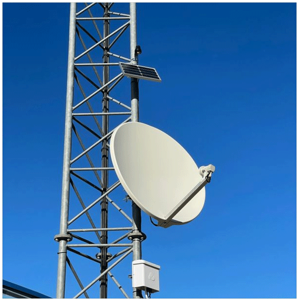
In this paper, we present and evaluate a new method for the quantitative estimation of precipitation from a low-cost sensor. Based on previous work measuring the attenuation of an electromagnetic signal from a broadcast television satellite, we make this approach more accurate so it can be easily deployed and used operationally in areas where rainfall measurements are critical for applications like flood monitoring. In this article, the method is validated in France and applied in Côte d'Ivoire.
Erlend Øydvin, Maximilian Graf, Christian Chwala, Mareile Astrid Wolff, Nils-Otto Kitterød, and Vegard Nilsen
Hydrol. Earth Syst. Sci., 28, 5163–5171, https://doi.org/10.5194/hess-28-5163-2024, https://doi.org/10.5194/hess-28-5163-2024, 2024
Short summary
Short summary
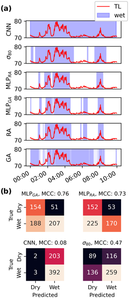
Two simple neural networks are trained to detect rainfall events using signal loss from commercial microwave links. Whereas existing rainfall event detection methods have focused on hourly resolution reference data, this study uses weather radar and rain gauges with 5 min and 1 min temporal resolutions, respectively. Our results show that the developed neural networks can detect rainfall events with a higher temporal precision than existing methods.
Maximilian Graf, Andreas Wagner, Julius Polz, Llorenç Lliso, José Alberto Lahuerta, Harald Kunstmann, and Christian Chwala
Atmos. Meas. Tech., 17, 2165–2182, https://doi.org/10.5194/amt-17-2165-2024, https://doi.org/10.5194/amt-17-2165-2024, 2024
Short summary
Short summary
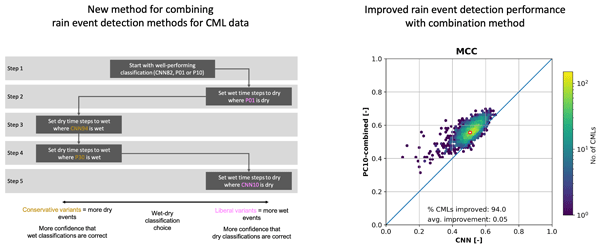
Commercial microwave links (CMLs) can be used for rainfall retrieval. The detection of rainy periods in their attenuation time series is a crucial processing step. We investigate the usage of rainfall data from MSG SEVIRI for this task, compare this approach with existing methods, and introduce a novel combined approach. The results show certain advantages for SEVIRI-based methods, particularly for CMLs where existing methods perform poorly. Our novel combination yields the best performance.
Greta Cazzaniga, Carlo De Michele, Michele D'Amico, Cristina Deidda, Antonio Ghezzi, and Roberto Nebuloni
Hydrol. Earth Syst. Sci., 26, 2093–2111, https://doi.org/10.5194/hess-26-2093-2022, https://doi.org/10.5194/hess-26-2093-2022, 2022
Short summary
Short summary
Rainfall estimates are usually obtained from rain gauges, weather radars, or satellites. An alternative is the measurement of the signal loss induced by rainfall on commercial microwave links (CMLs). In this work, we assess the hydrologic response of Lambro Basin when CML-retrieved rainfall is used as model input. CML estimates agree with rain gauge data. CML-driven discharge simulations show performance comparable to that from rain gauges if a CML-based calibration of the model is undertaken.
Cited articles
Adirosi, E., Facheris, L., Giannetti, F., Scarfone, S., Bacci, G., Mazza, A., Ortolani, A., and Baldini, L.: Evaluation of rainfall estimation derived from commercial interactive DVB receivers using disdrometer, rain gauge, and weather radar, IEEE T. Geosci. Remote, 59, 8978–8991, https://doi.org/10.1109/TGRS.2020.3041448, 2021. a
Andersson, J. C. M., Olsson, J., van de Beek, R. (C. Z.)., and Hansryd, J.: OpenMRG: Open data from Microwave links, Radar, and Gauges for rainfall quantification in Gothenburg, Sweden, Earth Syst. Sci. Data, 14, 5411–5426, https://doi.org/10.5194/essd-14-5411-2022, 2022. a, b
Angeloni, S., Adirosi, E., Sapienza, F., Giannetti, F., Francini, F., Magherini, L., Valgimigli, A., Vaccaro, A., Melani, S., Antonini, A., and Baldini, L.: Enhanced estimation of rainfall from opportunistic microwave satellite signals, IEEE T. Geosci. Remote, 62, 1–12, https://doi.org/10.1109/TGRS.2023.3349100, 2024. a
Arslan, C. H., Aydin, K., Urbina, J. V., and Dyrud, L.: Satellite-link attenuation measurement technique for estimating rainfall accumulation, IEEE T. Geosci. Remote, 56, 681–693, 2017. a
Barthès, L. and Mallet, C.: Rainfall measurement from the opportunistic use of an Earth–space link in the Ku band, Atmos. Meas. Tech., 6, 2181–2193, https://doi.org/10.5194/amt-6-2181-2013, 2013. a
Blettner, N., Chwala, C., Wiegels, R., Lang, R., and Kunstmann, H.: Evaluating CML rainfall processing methods on a countrywide scale in Zambia, J. Hydrometeorol., 26, 1603–1629, 2025. a
Capsoni, C., Luini, L., Paraboni, A., Riva, C., and Martellucci, A.: A New prediction model of rain attenuation that separately accounts for stratiform and convective rain, IEEE T. Antenn. Propag., 57, 196–204, https://doi.org/10.1109/TAP.2008.2009698, 2009. a
Chochon, R., Martin, N., Lebourg, T., and Vidal, M.: Analysis of Extreme Precipitation During the Mediterranean Event Associated with the Alex Storm in the Alpes-Maritimes: Atmospheric Mechanisms and Resulting Rainfall, 397–418, https://doi.org/10.1007/978-981-19-1600-7_26, 2022. a
Chwala, C., Graf, M., Polz, J., Blettner, N., DanSereb, Øydvin, E., keis f, overeem11, toufikshit, Kaleta, L., and yboose: pycomlink/pycomlink: v0.6.0, Zenodo [code], https://doi.org/10.5281/zenodo.18082259, 2025. a
Colli, M., Stagnaro, M., Caridi, A., Lanza, L. G., Randazzo, A., Pastorino, M., Caviglia, D. D., and Delucchi, A.: A field assessment of a rain estimation system based on satellite-to-Earth microwave links, IEEE T. Geosci. Remote, 57, 2864–2875, https://doi.org/10.1109/TGRS.2018.2878338, 2019. a
Colli, M., Cassola, F., Martina, F., Trovatore, E., Delucchi, A., Maggiolo, S., and Caviglia, D. D.: Rainfall fields monitoring based on satellite microwave down-links and traditional techniques in the city of Genoa, IEEE T. Geosci. Remote, 58, 6266–6280, 2020. a
Covi, E. and Roversi, G.: OpenRainER dataset, Zenodo [code], https://doi.org/10.5281/zenodo.10610886, 2024. a
Crane, R. K.: Electromagnetic Wave Propagation through Rain, Wiley, New York, ISBN 978-0-471-61376-3, 1996. a
Fabry, F. and Zawadzki, I.: Long-term radar observations of the melting layer of precipitation and their interpretation, J. Atmos. Sci., 52, 838–851, https://doi.org/10.1175/1520-0469(1995)052<0838:LTROOT>2.0.CO;2, 1995. a
Fencl, M., Nebuloni, R., Andersson, J. C., Bares, V., Blettner, N., Cazzaniga, G., Chwala, C., Colli, M., de Vos, L., El Hachem, A., Galdies, C., Giannetti, F., Graf, M., Jacoby, D., Habi, H. V., Musil, P., Ostrometzky, J., Roversi, G., Sapienza, F., Seidel, J., Spackova, A., van de Beek, R., Walraven, B., Wilgan, K., and Zheng, X.: Data formats and standards for opportunistic rainfall sensors, Open Research Europe, 3, 169, https://doi.org/10.12688/openreseurope.16068.2, 2024. a, b, c
Gelbart, L., Barthès, L., Mercier-Tigrine, F., Chazottes, A., and Mallet, C.: Enhanced quantitative precipitation estimation through the opportunistic use of Ku TV-SAT links via a dual-channel procedure, Atmos. Meas. Tech., 18, 351–370, https://doi.org/10.5194/amt-18-351-2025, 2025. a, b, c
Giannetti, F. and Reggiannini, R.: Opportunistic rain rate estimation from measurements of satellite downlink attenuation: a survey, Sensors, 21, https://doi.org/10.3390/s21175872, 2021. a
Giannetti, F., Reggiannini, R., Moretti, M., Adirosi, E., Baldini, L., Facheris, L., Antonini, A., Melani, S., Bacci, G., Petrolino, A., and Vaccaro, A.: Real-time rain rate evaluation via satellite downlink signal attenuation measurement, Sensors, 17, 1864, https://doi.org/10.3390/s17081864, 2017. a, b
Gianoglio, C., Zani, S., Colli, M., and Caviglia, D. D.: Rainfall classification in Genoa: machine learning vs. adaptive statistical models using satellite microwave links, IEEE Access, https://doi.org/10.1109/ACCESS.2024.3458407. 2024. a, b
Houze, R. A.: Stratiform precipitation in regions of convection: a meteorological paradox?, B. Am. Meteorol. Soc., 78, 2179–2196, https://doi.org/10.1175/1520-0477(1997)078<2179:SPIROC>2.0.CO;2, 1997. a
ITU-R P.839-4: Rain height model for prediction methods, Tech. rep., https://www.itu.int/dms_pubrec/itu-r/rec/p/R-REC-P.838-3-200503-I!!PDF-E.pdf (last access: 19 May 2026), 2013. a
Jacoby, D., Yu, S., Hu, S., Hine, Z., Johnson, R., Ostrometzky, J., Kadota, I., Messer, H., and Zussman, G.: OpenMesh dataset, Zenodo [code], https://doi.org/10.5281/zenodo.15268340, 2025. a
Leijnse, H., Uijlenhoet, R., and Stricker, J. N. M.: Rainfall measurement using radio links from cellular communication networks, Water Resour. Res., 43, https://doi.org/10.1029/2006WR005631, 2007a. a
Leijnse, H., Uijlenhoet, R., and Stricker, J. N. M.: Hydrometeorological application of a microwave link: 2. Precipitation, Water Resour. Res., 43, 9, https://doi.org/10.1029/2006WR004989, 2007b. a
Matrosov, S. Y.: Assessment of radar signal attenuation caused by the melting hydrometeor layer, IEEE T. Geosci. Remote, 46, 1039–1047, https://doi.org/10.1109/TGRS.2008.915757, 2008. a
Mercier, F., Barthès, L., and Mallet, C.: Estimation of finescale rainfall fields using broadcast TV satellite links and a 4DVAR assimilation method, J. Atmos. Ocean. Tech., 32, 1709–1728, 2015. a
Messer, H., Zinevich, A., and Alpert, P.: Environmental monitoring by wireless communication networks, Science, 312, 713–713, https://doi.org/10.1126/science.1120034, 2006. a
Mimeau, L., Tramblay, Y., Brocca, L., Massari, C., Camici, S., and Finaud-Guyot, P.: Modeling the response of soil moisture to climate variability in the Mediterranean region, Hydrol. Earth Syst. Sci., 25, 653–669, https://doi.org/10.5194/hess-25-653-2021, 2021. a
Météo-France: Fiche climatologique, https://donneespubliques.meteofrance.fr/?fond=produit&id_produit=117&id_rubrique=39, last access: 13 May 2025a. a
Météo-France: 2022 : les bilans climatiques, https://meteofrance.fr/actualite/publications/2022-les-bilans-climatiques, last access: 12 May 2025b. a
Nebuloni, R., Giannetti, F., Sapienza, F., Lottici, V., Adirosi, E., Roversi, G., Covi, E., Gianoglio, C., Colli, M., and Michele, C. D.: A review of technical aspects and challenges in opportunistic rainfall estimation using satellite and terrestrial microwave links: how wireless infrastructure can be used for rainfall monitoring, IEEE Geoscience and Remote Sensing Magazine, 13, 266–296, https://doi.org/10.1109/MGRS.2025.3573645, 2025a. a, b
Nebuloni, R., Graf, M., Cazzaniga, G., Mercier, F., and Turko, M.: The OpenSat4Weather dataset: Ku-band satellite link data for precipitation monitoring, Zenodo [code], https://doi.org/10.5281/zenodo.16530166, 2025b. a, b, c
Overeem, A., Leijnse, H., and Uijlenhoet, R.: Two and a half years of country-wide rainfall maps using radio links from commercial cellular telecommunication networks, Water Resour. Res., 52, 8039–8065, https://doi.org/10.1002/2016WR019412, 2016. a
Polz, J., Graf, M., and Chwala, C.: Missing rainfall extremes in commercial microwave link data due to complete loss of signal, Earth and Space Science, 10, e2022EA002456, https://doi.org/10.1029/2022EA002456, 2023. a
Quijada-Meza, C., Jacques-Coper, M., Garreaud, R. D., and Schauwecker, S.: Temporal variability of the 0 °C isotherm height over the coast of the Biobío region (36.8° S), Chile: characterisation and case studies, Int. J. Climatol., e70229, https://doi.org/10.1002/joc.70229, 2026. a
Schauwecker, S., Palma, G., MacDonell, S., Ayala, Á., and Viale, M.: The snowline and 0 °C isotherm altitudes during precipitation events in the dry subtropical Chilean Andes as seen by citizen science, surface stations, and ERA5 reanalysis data, Front. Earth Sci., 10, 875795, https://doi.org/10.3389/feart.2022.875795, 2022. a
Schleiss, M., Olsson, J., Berg, P., Niemi, T., Kokkonen, T., Thorndahl, S., Nielsen, R., Ellerbæk Nielsen, J., Bozhinova, D., and Pulkkinen, S.: The accuracy of weather radar in heavy rain: a comparative study for Denmark, the Netherlands, Finland and Sweden, Hydrol. Earth Syst. Sci., 24, 3157–3188, https://doi.org/10.5194/hess-24-3157-2020, 2020. a
Tabary, P., Boumahmoud, A.-A., Andrieu, H., Thompson, R. J., Illingworth, A. J., Le Bouar, E., and Testud, J.: Evaluation of two “integrated” polarimetric Quantitative Precipitation Estimation (QPE) algorithms at C-band, J. Hydrol., 405, 248–260, 2011. a
Thurai, M., Iguchi, T., Kozu, T., Eastment, J. D., Wilson, C. L., and Ong, J. T.: Radar observations in Singapore and their implications for the TRMM precipitation radar retrieval algorithms, Radio Sci., 38, https://doi.org/10.1029/2002RS002855, 2003. a
Wilkinson, M. D., Dumontier, M., Aalbersberg, I. J., Appleton, G., Axton, M., Baak, A., Blomberg, N., Boiten, J.-W., da Silva Santos, L. B., Bourne, P. E., Bouwman, J., Brookes, A. J., Clark, T., Crosas, M., Dillo, I., Dumon, O., Edmunds, S., Evelo, C. T., Finkers, R., Gonzalez-Beltran, A., Gray, A. J. G., Groth, P., Goble, C., Grethe, J. S., Heringa, J., 't Hoen, P. A. C., Hooft, R., Kuhn, T., Kok, R., Kok, J., Lusher, S. J., Martone, M. E., Mons, A., Packer, A. L., Persson, B., Rocca-Serra, P., Roos, M., van Schaik, R., Sansone, S.-A., Schultes, E., Sengstag, T., Slater, T., Strawn, G., Swertz, M. A., Thompson, M., van der Lei, J., van Mulligen, E., Velterop, J., Waagmeester, A., Wittenburg, P., Wolstencroft, K., Zhao, J., and Mons, B.: The FAIR guiding principles for scientific data management and stewardship, Scientific Data, 3, https://doi.org/10.1038/sdata.2016.18, 2016. a
Wolf, K., Bellouin, N., Boucher, O., Rohs, S., and Li, Y.: Correction of ERA5 temperature and relative humidity biases by bivariate quantile mapping for contrail formation analysis, Atmos. Chem. Phys., 25, 157–181, https://doi.org/10.5194/acp-25-157-2025, 2025. a
Xian, M., Liu, X., and Gao, T.: An improvement to precipitation inversion model using oblique Earth–space link based on the melting layer attenuation, IEEE T. Geosci. Remote, 59, 6451–6465, https://doi.org/10.1109/TGRS.2020.3027465, 2021. a
Short summary
We describe the OpenSat4Weather public dataset, which provides time series of received power from 215 TV-SAT satellite microwave links located in Southern France over a five-month observation period and at 1-min resolution. These data can be processed to gather indirect rainfall intensity measurements. OpenSat4Weather also includes concurrent data from operational rain gauges and weather radars, and ERA5 0°C isotherm height data, to derive the wet fraction of the satellite-to-ground path.
We describe the OpenSat4Weather public dataset, which provides time series of received power...


Altmetrics
Final-revised paper
Preprint