Articles | Volume 18, issue 10
https://doi.org/10.5194/essd-18-7301-2026
© Author(s) 2026. This work is distributed under
the Creative Commons Attribution 4.0 License.
https://doi.org/10.5194/essd-18-7301-2026
© Author(s) 2026. This work is distributed under
the Creative Commons Attribution 4.0 License.
HyBEAR: a hyperspectral benchmark for bare soil detection

Agata M. Wijata
CORRESPONDING AUTHOR
Silesian University of Technology, Akademicka 2A, 44-100 Gliwice, Poland
Centre for Credible Artificial Intelligence (CCAI), Warsaw University of Technology, Rektorska 4, 00-614 Warsaw, Poland
KP Labs, Bojkowska 37J, 44-100 Gliwice, Poland
Faculty of Computer Science, Opole University of Technology, Prószkowska 76, 45-758 Opole, Poland
Faculty of Space Technologies, AGH University of Kraków, Mickiewicza 30, 30-059 Kraków, Poland
Michal Gumiela
KP Labs, Bojkowska 37J, 44-100 Gliwice, Poland
Krzysztof Smykala
Faculty of Computer Science, Opole University of Technology, Prószkowska 76, 45-758 Opole, Poland
QZ Solutions Sp. z o.o., Technologiczna 2, 45-839 Opole, Poland
Nicolas Longépé
ϕ-Lab, European Space Agency, Largo Galileo Galilei 1, 00044 Frascati, Italy
Jakub Nalepa
Silesian University of Technology, Akademicka 2A, 44-100 Gliwice, Poland
KP Labs, Bojkowska 37J, 44-100 Gliwice, Poland
ϕ-Lab, European Space Agency, Largo Galileo Galilei 1, 00044 Frascati, Italy
Related authors
No articles found.
Gilberto Goracci, Ilias Daras, and Nicolas Longepe
EGUsphere, https://doi.org/10.5194/egusphere-2026-4563, https://doi.org/10.5194/egusphere-2026-4563, 2026
Short summary
Short summary
Satellite measurements of changes in water stored on land are too coarse for many regional applications. We used a deep-learning method to improve the resolution of these maps to 1 degree while preserving the original large-scale signal. Tests with simulated future missions and real observations showed that better input data produced more reliable detailed maps, with the strongest results for monthly products. The approach could support improved monitoring of regional water changes.
Andreas Stokholm, Jørgen Buus-Hinkler, Tore Wulf, Anton Korosov, Roberto Saldo, Leif Toudal Pedersen, David Arthurs, Ionut Dragan, Iacopo Modica, Juan Pedro, Annekatrien Debien, Xinwei Chen, Muhammed Patel, Fernando Jose Pena Cantu, Javier Noa Turnes, Jinman Park, Linlin Xu, Katharine Andrea Scott, David Anthony Clausi, Yuan Fang, Mingzhe Jiang, Saeid Taleghanidoozdoozan, Neil Curtis Brubacher, Armina Soleymani, Zacharie Gousseau, Michał Smaczny, Patryk Kowalski, Jacek Komorowski, David Rijlaarsdam, Jan Nicolaas van Rijn, Jens Jakobsen, Martin Samuel James Rogers, Nick Hughes, Tom Zagon, Rune Solberg, Nicolas Longépé, and Matilde Brandt Kreiner
The Cryosphere, 18, 3471–3494, https://doi.org/10.5194/tc-18-3471-2024, https://doi.org/10.5194/tc-18-3471-2024, 2024
Short summary
Short summary
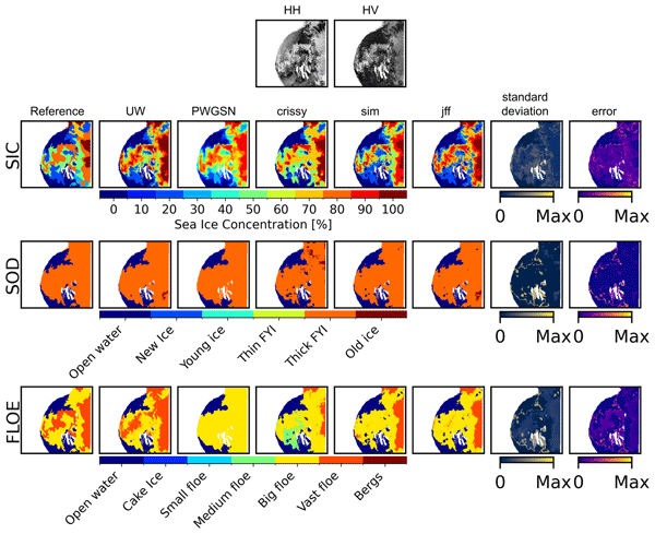
The AutoICE challenge encouraged the development of deep learning models to map multiple aspects of sea ice – the amount of sea ice in an area and the age and ice floe size – using multiple sources of satellite and weather data across the Canadian and Greenlandic Arctic. Professionally drawn operational sea ice charts were used as a reference. A total of 179 students and sea ice and AI specialists participated and produced maps in broad agreement with the sea ice charts.
Andreas Stokholm, Andrzej Kucik, Nicolas Longépé, and Sine Munk Hvidegaard
EGUsphere, https://doi.org/10.5194/egusphere-2023-976, https://doi.org/10.5194/egusphere-2023-976, 2023
Preprint archived
Short summary
Short summary
To navigate in the Arctic, vessels utilise maps of the local sea ice conditions, that are manually drawn daily. This is a time-consuming and labour-intensive task, which we are trying to automate using convolutional neural networks. In this article, we investigate combining the outputs of models trained with different objectives, leveraging the strengths and avoiding weaknesses to create precise and detailed sea ice concentration maps for navigation in the Arctic and climate or weather models.
Cited articles
Adão, T., Hruška, J., Pádua, L., Bessa, J., Peres, E., Morais, R., and Sousa, J. J.: Hyperspectral Imaging: A Review on UAV-Based Sensors, Data Processing and Applications for Agriculture and Forestry, Remote Sens., 9, https://doi.org/10.3390/rs9111110, 2017. a
Aijaz, N., Lan, H., Raza, T., Yaqub, M., Iqbal, R., and Pathan, M. S.: Artificial Intelligence in Agriculture: Advancing Crop Productivity and Sustainability, Journal of Agriculture and Food Research, 20, 101762, https://doi.org/10.1016/j.jafr.2025.101762, 2025. a, b
Allied Market Research: Smart Agriculture Market by Type and Component: Opportunity Analysis and Industry Forecast, 2021–2027, Tech. rep., Allied Market Research, https://www.alliedmarketresearch.com/smart-agriculture-market (last access: 14 November 2025), 2023. a
Boguszewska-Mańkowska, D., Ruszczak, B., and Zarzyńska, K.: Classification of Potato Varieties Drought Stress Tolerance Using Supervised Learning, Appl. Sci., 12, https://doi.org/10.3390/app12041939, 2022. a
Bünemann, E. K., Bongiorno, G., Bai, Z., Creamer, R. E., De Deyn, G., de Goede, R., Fleskens, L., Geissen, V., Kuyper, T. W., Mäder, P., Pulleman, M., Sukkel, W., van Groenigen, J. W., and Brussaard, L.: Soil Quality – A Critical Review, Soil Biol. Biochem., 120, 105–125, https://doi.org/10.1016/j.soilbio.2018.01.030, 2018. a
Cai, M., Xi, B., Li, J., Feng, S., Li, Y., Li, Z., and Chanussot, J.: Mind the Gap: Multilevel Unsupervised Domain Adaptation for Cross-Scene Hyperspectral Image Classification, IEEE T. Geosci. Remote, 62, 1–14, https://doi.org/10.1109/TGRS.2024.3407952, 2024. a
Campos, L. R., Demattê, J. A., Bellinaso, H., Poppiel, R. R., Greschuk, L. T., Rizzo, R., Rosin, N. A., and Rosas, J. T. F.: Detection of Bare Soils in Sugarcane Areas by Temporal Satellite Images: A Monitoring Technique for Soil Security, Soil Security, 7, 100057, https://doi.org/10.1016/j.soisec.2022.100057, 2022. a, b, c
Chen, S., Arrouays, D., Leatitia Mulder, V., Poggio, L., Minasny, B., Roudier, P., Libohova, Z., Lagacherie, P., Shi, Z., Hannam, J., Meersmans, J., de Forges, A. C. R., and Walter, C.: Digital Mapping of GlobalSoilMap Soil Properties at a Broad Scale: A Review, Geoderma, 409, 115567, https://doi.org/10.1016/j.geoderma.2021.115567, 2022. a, b, c, d
Chicco, D., Tötsch, N., and Jurman, G.: The Matthews Correlation Coefficient (MCC) is More Reliable Than Balanced Accuracy, Bookmaker Informedness, and Markedness in Two-Class Confusion Matrix Evaluation, BioData Min., 14, 13, https://doi.org/10.1186/s13040-021-00244-z, 2021. a
Delaney, B., Tansey, K., and Whelan, M.: Satellite Remote Sensing Techniques and Limitations for Identifying Bare Soil, Remote Sens., 17, https://doi.org/10.3390/rs17040630, 2025. a
Finger, R., Swinton, S. M., El Benni, N., and Walter, A.: Precision Farming at the Nexus of Agricultural Production and the Environment, Annu. Rev. Resour. Econ., 11, 313–335, https://doi.org/10.1146/annurev-resource-100518-093929, 2019. a
Grabowski, B., Ziaja, M., Kawulok, M., Cwiek, M., Lakota, T., Longépé, N., and Nalepa, J.: Are Cloud Detection U-Nets Robust Against in-Orbit Image Acquisition Conditions?, in: IGARSS 2022 – 2022 IEEE International Geoscience and Remote Sensing Symposium, IEEE, 239–242, https://doi.org/10.1109/IGARSS46834.2022.9884919, 2022. a, b
Grabowski, B., Ziaja, M., Kawulok, M., Bosowski, P., Longépé, N., Le Saux, B., and Nalepa, J.: Squeezing Adaptive Deep Learning Methods with Knowledge Distillation for On-Board Cloud Detection, Eng. Appl. Artif. Intel., 132, https://doi.org/10.1016/j.engappai.2023.107835, 2024. a, b
Guerri, M. F., Distante, C., Spagnolo, P., Bougourzi, F., and Taleb-Ahmed, A.: Deep Learning Techniques for Hyperspectral Image Analysis in Agriculture: A Review, ISPRS Open Journal of Photogrammetry and Remote Sensing, 12, 100062, https://doi.org/10.1016/j.ophoto.2024.100062, 2024. a
Han, L., Yang, G., Dai, H., Xu, B., Yang, H., Feng, H., Li, Z., and Yang, X.: Modeling Maize Above-Ground Biomass Based on Machine Learning Approaches using UAV Remote-Sensing Data, Plant Methods, 15, 1746–4811, https://doi.org/10.1186/s13007-019-0394-z, 2019. a
Hong, Y., Chen, S., Chen, Y., Linderman, M., Mouazen, A. M., Liu, Y., Guo, L., Yu, L., Liu, Y., Cheng, H., and Liu, Y.: Comparing Laboratory and Airborne Hyperspectral Data for the Estimation and Mapping of Topsoil Organic Carbon: Feature Selection Coupled with Random Forest, Soil Till. Res., 199, 104589, https://doi.org/10.1016/j.still.2020.104589, 2020. a
Izquierdo-Verdiguier, E. and Zurita-Milla, R.: An Evaluation of Guided Regularized Random Forest for Classification and Regression Tasks in Remote Sensing, Int. J. Appl. Earth Obs., 88, 102051, https://doi.org/10.1016/j.jag.2020.102051, 2020. a
Ji, S., Zhang, C., Xu, A., Shi, Y., and Duan, Y.: 3D Convolutional Neural Networks for Crop Classification with Multi-Temporal Remote Sensing Images, Remote Sens., 10, https://doi.org/10.3390/rs10010075, 2018. a
Jin, X., Li, Z., Feng, H., Ren, Z., and Li, S.: Deep neural network algorithm for estimating maize biomass based on simulated Sentinel 2A vegetation indices and leaf area index, The Crop Journal, 8, 87–97, https://doi.org/10.1016/j.cj.2019.06.005, 2020. a, b
Joshi, G. P., Alenezi, F., Thirumoorthy, G., Dutta, A. K., and You, J.: Ensemble of Deep Learning-Based Multimodal Remote Sensing Image Classification Model on Unmanned Aerial Vehicle Networks, Mathematics, 9, https://doi.org/10.3390/math9222984, 2021. a
Kapoor, S. and Narayanan, A.: Leakage and the reproducibility crisis in machine-learning-based science, Patterns, 4, 100804, https://doi.org/10.1016/j.patter.2023.100804, 2023. a, b
Kaur, R. and Pandey, P.: A Review on Spectral Indices for Built-up Area Extraction using Remote Sensing Technology, Arab. J. Geosci., 15, 391, https://doi.org/10.1007/s12517-022-09688-x, 2022. a
Liu, Y., Meng, Q., Zhang, L., and Wu, C.: NDBSI: A Normalized Difference Bare Soil Index for Remote Sensing to Improve Bare Soil Mapping Accuracy in Urban and Rural Areas, CATENA, 214, 106265, https://doi.org/10.1016/j.catena.2022.106265, 2022. a
Liu, Y., Li, W., Liu, L., Zhou, J., Peng, B., Song, Y., Xiong, X., Yang, W., Liu, T., Liu, Z., and Li, X.: ATRNet-STAR: A Large Dataset and Benchmark Toward Remote Sensing Object Recognition in the Wild, IEEE T. Pattern Anal., 48, 6735–6753, https://doi.org/10.1109/TPAMI.2026.3658649, 2026. a
Lu, B. and He, Y.: Evaluating Empirical Regression, Machine Learning, and Radiative Transfer Modelling for Estimating Vegetation Chlorophyll Content Using Bi-Seasonal Hyperspectral Images, Remote Sens., 11, https://doi.org/10.3390/rs11171979, 2019. a, b
Lu, B., Dao, P. D., Liu, J., He, Y., and Shang, J.: Recent Advances of Hyperspectral Imaging Technology and Applications in Agriculture, Remote Sens., 12, https://doi.org/10.3390/rs12162659, 2020. a, b
Meng, X., Bao, Y., Liu, J., Liu, H., Zhang, X., Zhang, Y., Wang, P., Tang, H., and Kong, F.: Regional Soil Organic Carbon Prediction Model Based on a Discrete Wavelet Analysis of Hyperspectral Satellite Data, Int. J. Appl. Earth Obs., 89, 102111, https://doi.org/10.1016/j.jag.2020.102111, 2020. a
Miroszewski, A., Nalepa, J., Wijata, A. M., Mielczarek, J., Saux, B. L., and Sebastianelli, A.: Quo Vadis, Quantum Machine Learning?: Quantum kernel methods meet Earth observation, IEEE Geoscience and Remote Sensing Magazine, 2–30, https://doi.org/10.1109/MGRS.2025.3596291, 2026. a
Misara, R., Verma, D., Mishra, N., Rai, S. K., and Mishra, S.: Twenty-Two Years of Precision Agriculture: a Bibliometric Review, Precis. Agric., 23, 2135–2158, https://doi.org/10.1007/s11119-022-09969-1, 2022. a
Nalepa, J., Le Saux, B., Longépé, N., Tulczyjew, L., Myller, M., Kawulok, M., Smykala, K., and Gumiela, M.: The Hyperview Challenge: Estimating Soil Parameters from Hyperspectral Images, in: 2022 IEEE International Conference on Image Processing (ICIP), IEEE, 4268–4272, https://doi.org/10.1109/ICIP46576.2022.9897443, 2022. a, b
Nalepa, J., Tulczyjew, L., Le Saux, B., Longépé, N., Ruszczak, B., Wijata, A. M., Smykala, K., Myller, M., Kawulok, M., Kuzu, R. S., Albrecht, F., Arnold, C., Alasawedah, M., Angeli, S., Nobileau, D., Ballabeni, A., Lotti, A., Locarini, A., Modenini, D., Tortora, P., and Gumiela, M.: Estimating Soil Parameters from Hyperspectral Images: A Benchmark Dataset and the Outcome of the HYPERVIEW Challenge, IEEE Geoscience and Remote Sensing Magazine, 12, 35–63, https://doi.org/10.1109/MGRS.2024.3394040, 2024. a, b, c, d, e, f, g
Nejatian, A., Makian, M., Gheibi, M., and Fathollahi-Fard, A.: A Novel Viewpoint to the Green City Concept Based on Vegetation Area Changes and Contributions to Healthy Days: a Case Study of Mashhad, Iran, Environ. Sci. Pollut. R., 29, 1–9, https://doi.org/10.1007/s11356-021-15552-4, 2022. a
Nguyen, C. T., Chidthaisong, A., Kieu Diem, P., and Huo, L.-Z.: A Modified Bare Soil Index to Identify Bare Land Features during Agricultural Fallow-Period in Southeast Asia Using Landsat 8, Land, 10, https://doi.org/10.3390/land10030231, 2021. a
Nowak, B.: Precision Agriculture: Where do We Stand? A Review of the Adoption of Precision Agriculture Technologies on Field Crops Farms in Developed Countries, Agr. Res., 10, 515–522, https://doi.org/10.1007/s40003-021-00539-x, 2021. a
Pechanec, V., Mráz, A., Rozkošný, L., and Vyvlečka, P.: Usage of Airborne Hyperspectral Imaging Data for Identifying Spatial Variability of Soil Nitrogen Content, ISPRS Int. J. Geo-Inf., 10, https://doi.org/10.3390/ijgi10060355, 2021. a
Pingali, P. L.: Green Revolution: Impacts, Limits, and the Path Ahead, P. Natl. Acad. Sci. USA, 109, 12302–12308, https://doi.org/10.1073/pnas.0912953109, 2012. a
Ponnusamy, V. and Natarajan, S.: Precision Agriculture Using Advanced Technology of IoT, Unmanned Aerial Vehicle, Augmented Reality, and Machine Learning, in: Smart Sensors for Industrial Internet of Things: Challenges, Solutions and Applications, edited by: Gupta, D., Hugo C., de Albuquerque, V., Khanna, A., and Mehta, P. L., 207–229, Springer International Publishing, Cham, ISBN 978-3-030-52624-5, https://doi.org/10.1007/978-3-030-52624-5_14, 2021. a, b
Powers, D. M. W.: Evaluation: From Precision, Recall and F-measure to ROC, Informedness, Markedness and Correlation, arXiv [preprint], https://doi.org/10.48550/arXiv.2010.16061, 2011. a, b
Roy, A., Moradkhani, H., Mekonnen, M., Moftakhari, H., and Magliocca, N.: Towards Strategic Interventions for Global Food Security in 2050, Sci. Total Environ., 954, 176811, https://doi.org/10.1016/j.scitotenv.2024.176811, 2024. a
Ruszczak, B. and Boguszewska-Mańkowska, D.: Deep Potato – The Hyperspectral Imagery of Potato Cultivation with Reference Agronomic Measurements Dataset: Towards Potato Physiological Features Modeling, Data in Brief, 42, 108087, https://doi.org/10.1016/j.dib.2022.108087, 2022. a
Rutter, E. B., Ruiz Diaz, D., and Hargrave, L. M.: Evaluation of Mehlich-3 for Determination of Cation Exchange Capacity in Kansas Soils, Soil Sci. Soc. Am. J., 86, 146–156, https://doi.org/10.1002/saj2.20354, 2022. a
Saha, S., Saha, M., Mukherjee, K., Arabameri, A., Ngo, P. T. T., and Paul, G. C.: Predicting the Deforestation Probability Using the Binary Logistic Regression, Random Forest, Ensemble Rotational Forest, REPTree: A Case Study at the Gumani River Basin, India, Sci. Total Environ., 730, 139197, https://doi.org/10.1016/j.scitotenv.2020.139197, 2020. a, b
Sayão, V. M., dos Santos, N. V., de Sousa Mendes, W., Marques, K. P., Safanelli, J. L., Poppiel, R. R., and Demattê, J. A.: Land Use/Land Cover Changes and Bare Soil Surface Temperature Monitoring in Southeast Brazil, Geoderma Regional, 22, e00313, https://doi.org/10.1016/j.geodrs.2020.e00313, 2020. a
Seu, D., Longepe, N., Cioltea, G., Maidik, E., and Andrei, C.: Seeing Soil from Space: Towards Robust and Scalable Remote Soil Nutrient Analysis, arXiv [preprint], https://doi.org/10.48550/arXiv.2512.09576, 2025. a
Sishodia, R. P., Ray, R. L., and Singh, S. K.: Applications of Remote Sensing in Precision Agriculture: A Review, Remote Sens., 12, https://doi.org/10.3390/rs12193136, 2020. a, b
Song, Y., Zhao, X., Su, H.-Y., Li, B., Hu, Y.-M., and Cui, X.-S.: Predicting Spatial Variations in Soil Nutrients with Hyperspectral Remote Sensing at Regional Scale, Sensors, 18, 3086, https://doi.org/10.3390/s18093086, 2018. a, b
Tan, K., Zhu, L., and Wang, X.: A Hyperspectral Feature Selection Method for Soil Organic Matter Estimation Based on an Improved Weighted Marine Predators Algorithm, IEEE T. Geosci. Remote, 63, 1–11, https://doi.org/10.1109/TGRS.2024.3422475, 2025. a
Tunçay, T., Şeref Kılıç, Dedeoğlu, M., Dengiz, O., Başkan, O., and İlhami Bayramin: Assessing Soil Fertility Index Based on Remote Sensing and GIS Techniques with Field Validation in a Semiarid Agricultural Ecosystem, J. Arid Environ., 190, 104525, https://doi.org/10.1016/j.jaridenv.2021.104525, 2021. a
Vlachopoulos, O., Leblon, B., Wang, J., Haddadi, A., LaRocque, A., and Patterson, G.: Delineation of Bare Soil Field Areas from Unmanned Aircraft System Imagery with the Mean Shift Unsupervised Clustering and the Random Forest Supervised Classification, Can. J. Remote Sens., 46, 489–500, https://doi.org/10.1080/07038992.2020.1763789, 2020. a
Wang, X., Zhang, Y., Atkinson, P. M., and Yao, H.: Predicting Soil Organic Carbon Content in Spain by Combining Landsat TM and ALOS PALSAR Images, Int. J. Appl. Earth Obs., 92, 102182, https://doi.org/10.1016/j.jag.2020.102182, 2020. a
Wijata, A., Ruszczak, B., Niepala, A., Gumiela, M., Smykała, K., Longepe, N., and Nalepa, J.: HyBEAR, Zenodo [data set], https://doi.org/10.5281/zenodo.17607897, 2025. a, b, c, d
Wijata, A. M., Foulon, M.-F., Bobichon, Y., Vitulli, R., Celesti, M., Camarero, R., Di Cosimo, G., Gascon, F., Longépé, N., Nieke, J., Gumiela, M., and Nalepa, J.: Taking Artificial Intelligence Into Space Through Objective Selection of Hyperspectral Earth Observation Applications: To Bring the “Brain” Close to the “Eyes” of Satellite Missions, IEEE Geoscience and Remote Sensing Magazine, 11, 10–39, https://doi.org/10.1109/MGRS.2023.3269979, 2023. a, b
Wijata, A. M., Lakota, T., Cwiek, M., Ruszczak, B., Gumiela, M., Tulczyjew, L., Bartoszek, A., Longépé, N., Smykala, K., and Nalepa, J.: Intuition-1: Toward In-Orbit Bare Soil Detection Using Spectral Vegetation Indices, in: IGARSS 2024–2024 IEEE International Geoscience and Remote Sensing Symposium, IEEE, 1708–1712, https://doi.org/10.1109/IGARSS53475.2024.10640702, 2024a. a
Wijata, A. M., Miroszewski, A., Saux, B. L., Longépé, N., Ruszczak, B., and Nalepa, J.: Detection of Bare Soil in Hyperspectral Images Using Quantum-Kernel Support Vector Machines, in: IGARSS 2024–2024 IEEE International Geoscience and Remote Sensing Symposium, IEEE, 817–822, https://doi.org/10.1109/IGARSS53475.2024.10641442, 2024b. a
Xu, J., Cui, Y., Zhang, S., and Zhang, M.: The Evolution of Precision Agriculture and Food Safety: a Bibliometric Study, Frontiers in Sustainable Food Systems, 8, 1475602, https://doi.org/10.3389/fsufs.2024.1475602, 2024. a
Yan, Y., Yang, J., Li, B., Qin, C., Ji, W., Xu, Y., and Huang, Y.: High-Resolution Mapping of Soil Organic Matter at the Field Scale Using UAV Hyperspectral Images with a Small Calibration Dataset, Remote Sens., 15, https://doi.org/10.3390/rs15051433, 2023. a
Yue, J., Zhou, C., Guo, W., Feng, H., and Xu, K.: Estimation of Winter-Wheat Above-Ground Biomass using the Wavelet Analysis of Unmanned Aerial Vehicle-Based Digital Images and Hyperspectral Crop Canopy Images, Int. J. Remote Sens., 42, 1602–1622, https://doi.org/10.1080/01431161.2020.1826057, 2021. a, b, c, d, e
Zhang, Y., Xia, C., Zhang, X., Cheng, X., Feng, G., Wang, Y., and Gao, Q.: Estimating the Maize Biomass by Crop Height and Narrowband Vegetation Indices Derived from UAV-based Hyperspectral Images, Ecol. Indic., 129, 107985, https://doi.org/10.1016/j.ecolind.2021.107985, 2021. a, b, c
Zhang, Y., Liang, L., Li, J., Plaza, A., Kang, X., Mao, J., and Wang, Y.: Structural and Textural-Aware Feature Extraction for Hyperspectral Image Classification, IEEE Geosci. Remote S., 21, 1–5, https://doi.org/10.1109/LGRS.2024.3357201, 2024. a
Zhao, J., Du, D., Chen, L., Liang, X., Chen, H., and Jin, Y.: HA-Net for Bare Soil Extraction Using Optical Remote Sensing Images, Remote Sens., 16, https://doi.org/10.3390/rs16163088, 2024. a, b, c
Zhu, C., Ding, J., Zhang, Z., and Wang, Z.: Exploring the Potential of UAV Hyperspectral Image for Estimating Soil Salinity: Effects of Optimal Band Combination Algorithm and Random Forest, Spectrochim. Acta A, 279, 121416, https://doi.org/10.1016/j.saa.2022.121416, 2022. a
Short summary
The bare soil areas detection is an important step for Earth observation and Precision Agriculture applications. The HyBEAR is a novel large-scale dataset of high-res hyperspectral images, with 2 m ground sampling distance, and manual bare soil annotations verified by experts. It includes the largest-to-date dataset (108 mln pixels), the validation procedure, and initial results. The entire parcel's pixel-level labels enable developing the methods for entire fields with no vegetation detection.
The bare soil areas detection is an important step for Earth observation and Precision...
Altmetrics
Final-revised paper
Preprint