the Creative Commons Attribution 4.0 License.
the Creative Commons Attribution 4.0 License.
 | 01 Oct 2026
A harmonized dataset for dams and reservoirs in West Africa
Valery Bessely Stanislas Kouassi

Blé Anouma Fhorest Yao
Gneneyougo Emile Soro
Bi Tié Albert Goula
Nelly Carine Kelome
Julian Klaus
Most existing datasets that could support dam and reservoir management and assessments of their impacts in West Africa are limited by inaccurate georeferencing, inconsistent accessibility, heterogeneous data records, and a lack of validation against field observations. In this study, we review and assess existing datasets containing information on dams and reservoirs in West Africa and subsequently integrate them into a harmonized and consolidated regional dataset. We benchmarked the quality of the newly compiled dataset at watershed scale through an extended field study, and statistical analyses. The resulting dataset (https://doi.org/10.60507/FK2/YLDK1Y, Kouassi et al., 2026) includes 1429 georeferenced dams and 1258 reservoirs (with a minimum surface of km2) exceeding the count of dams and reservoirs in West Africa reported by any available dataset. It contains 38 attributes and an estimated total reservoir surface area of 14 038 km2 and a cumulative storage capacity of 2.83032×10¹¹ m3, thereby enhancing data accessibility in West Africa. The regional compiled dataset contains fewer missing entries and exhibits lower bias compared to the originate datasets, advancing the existing efforts by explicitly integrating both large (≥10 km2) and small (<10 km2) scale reservoirs. The ground-based watershed scale assessment revealed strong spatial and temporal coherence for large scale reservoirs, but a systematic underrepresentation of small scale infrastructure in both the sources and thus also in the compiled dataset highlighting the importance of field validation. The field benchmarking advocates for collaborative research and data sharing initiatives among scientists and institutions across West Africa to improve the accuracy and completeness of dam and reservoir data, especially for small scale infrastructure.
- Article
(7304 KB) - Full-text XML
- BibTeX
- EndNote


Unprecedented population growth, climate change, rapid urbanization, infrastructure expansion, and land-use conversion collectively alter the fluxes, pathways, and storage of water across multiple scales (Makarigakis and Jimenez-Cisneros, 2019). These components of global change increasingly affect water resources, pose substantial challenges to water security, and complicate the efforts of water managers and decision-makers to balance supply with growing demand (Klein and Kenney, 2009; Cosgrove and Loucks, 2015). Dams and their associated reservoirs, a longstanding element of water management in many regions, play a central role in tackling the growing challenges of climate change, population growth, urbanization, and hydrological extremes (Wheater and Gober, 2015; Zhang and Gu, 2023). These infrastructures are engineered to store and regulate water supply, mitigate floods, generate hydropower, and support irrigation, thereby ensuring the provision of essential water services during periods of both abundance and scarcity (Watts et al., 2011; Wheater and Gober, 2015; Eslamian et al., 2018). Their multifunctional capabilities make dams and reservoirs a valuable tool for enhancing water security, especially in regions where climate variability and extreme hydrological events are increasingly common (Ehsani et al., 2017).
Estimates suggest there are around 58 000 large dams and more than 16 million smaller impoundments globally, collectively transforming terrestrial surface water dynamics and local climate (Li et al., 2023). This transformation is particularly evident in regions where water scarcity and variability of precipitation put agricultural productivity and socio-economic stability at risk (Yazdandoost, 2016; Mady et al., 2020). Across West Africa's semi-arid areas, governments and development agencies have constructed over 2000 small reservoirs to increase water storage capacity, thereby supporting irrigation, strengthening food security, and fostering income diversification (Cecchi et al., 2009a; Abobi and Wolff, 2020; Cecchi et al., 2020; Lèye et al., 2021; Owusu et al., 2022). Additionally, hydro-economic analyses have shown that multiple, smaller dams can generate substantial economic returns by optimizing water allocations for high-value irrigated crops while minimizing hydrological alterations (Ekka et al., 2024). Such findings highlight that artificial reservoirs function as dynamic systems that can improve livelihoods and strengthen resilience to climatic extremes in regions exposed to water security threats.
Despite their benefits, dams and their associated reservoirs are vulnerable to global change that threatens their operational reliability, safety, and functionality (Fluixá-Sanmartín et al., 2018; Ghimire and Schulenberg, 2022). Changes in precipitation patterns, increasing frequency of extreme weather events, and rising temperatures directly affect reservoir inflow volumes and timing, making it more difficult to predict and manage storage and release (Hou et al., 2022) and thus increasing the challenges of flood risk management. In addition, rising temperatures have been linked to increased evaporation rates from reservoir surfaces, which can significantly reduce stored water volumes, particularly in arid and semi-arid regions (Helfer et al., 2012). This is particularly true for West Africa, where already high interannual variability in the hydrological cycle is intensified by changing precipitation patterns, rising temperatures, and more frequent extreme weather events (Oyerinde et al., 2016; Chun et al., 2021). Besides their vulnerability to global change, dams and their associated reservoirs have increasingly become the focus of serious criticism due to their numerous social, environmental, and economic impacts (Kaup, 2015; Latrubesse et al., 2017). Multiple studies highlight the detrimental effects of dam construction on ecosystems and biodiversity, indicating a general consensus among scientists about the challenges posed by these infrastructures (Magilligan and Nislow, 2001; Ziv et al., 2012; Kaup, 2015; Latrubesse et al., 2017).
Given these intensifying pressures, there is a critical need to implement adaptive water resources management strategies that combine robust data, advanced observational technologies, predictive modelling, and comprehensive risk assessment (Boulange et al., 2021; Fluixá-Sanmartín et al., 2021). This is essential to safeguard the structural integrity of dams, the ecological and socio-economic systems they support while effectively managing their impacts (Boulange et al., 2021; Fluixá-Sanmartín et al., 2021). Makarigakis and Jimenez-Cisneros (2019) emphasized that improving data quality and ensuring data accessibility is critical for the assessment, prediction, and mitigation of global change. Yet, access to hydrological data including information on dams and reservoirs remains limited in West Africa, due either to a considerable lack of data or to complex and time-consuming procedures that are required to obtain the data where it exists (Ndehedehe, 2019; Anghileri et al., 2024). Consequently, researchers and practitioners frequently rely on global datasets. The emergence of comprehensive global geospatial databases has improved the quality, spatial coverage, and detail of available information on dams and reservoirs (Mu et al., 2020; Mulligan et al., 2020; Mulligan et al., 2021; Wang et al., 2022; ICOLD, 2024; Lehner et al., 2024).
Although these integrated datasets are critical for supporting cross-scale analyses, they still exhibit notable gaps that can limit the sustainable management of dams and their reservoirs. One key gap is the inconsistency in the number of West African dam and reservoir entries across existing datasets (Zhang and Gu, 2023). This suggests that some datasets underestimate the number of dams and reservoirs, thereby limiting their completeness, accuracy, and reliability. Furthermore, the current datasets provide various attributes related to dams and reservoirs; however, many datasets exhibit disparities and missing records, thus challenging efforts to support robust and informed decision-making (Mirus et al., 2011; Zarfl et al., 2015; Zogheib et al., 2018; Zhang and Gu, 2023; Bai et al., 2025). These inconsistencies lead to incomplete assessments of dam effects on ecosystems and surrounding communities (Lehner et al., 2011; Lehner and Grill, 2013; Joseph et al., 2018; Dang et al., 2020), undermining the accuracy of environmental and social impact assessments. This issue is further exacerbated by the fact that the quality of most datasets has not yet been evaluated using field-observed data from the West African region (Du et al., 2022; Zhang and Gu, 2023; Bai et al., 2025). This lack of regional validation limits the ability to effectively assess the reliability and uncertainty of hydrological, climate, and land-surface models developed for the region based on these datasets (McManamay, 2014; Yassin et al., 2019).
Given these challenges, this study reviews and assesses existing datasets on dams and reservoirs in West Africa, integrates them into a harmonized and consolidated regional dataset, and benchmarks the resulting compiled dataset against field-campaign data at watershed scale to evaluate its quality.
The key contributions of this study include: (i) a critical review and comparison of existing datasets containing information on West African dams and reservoirs; (ii) the development of a new, region-specific dataset from the consolidation of multiple datasets; and (iii) a watershed scale ground-truthing assessment of the quality of existing dam and reservoir data.
2.1 Study area
West Africa, lies between latitudes 0 and 20° N and longitudes 20° W to 20° E (Fig. 1), and is home to approximately 456 million inhabitants (The United Nations – Department of Economic and Social Affairs, 2024). West Africa exhibits pronounced climatic variability on intra-seasonal to multidecadal timescales, with aridity increasing progressively inland. Three primary climatic zones are typically distinguished (Fink et al., 2017; Quenum et al., 2019; Ndao et al., 2020): (a) The Sahelian zone (∼12.5° N), a semi-arid belt that transitions into the Sahara desert, with highly irregular rainfall ranging from approximately 150 to 600 mm year−1, typically peaking in August; (b) the Sudanian (savannah) zone (9 to 12.5° N), a sub-humid region influenced by the West African Monsoon, receiving around 200 to 1000 mm year−1, and (c) the Guinean coastal zone (4 to 9° N), a humid tropical region characterized by a bimodal rainfall regime driven by the seasonal movement of the Inter-Tropical Discontinuity (ITD), with precipitation generally ranging from 1600 to 2000 mm year−1.
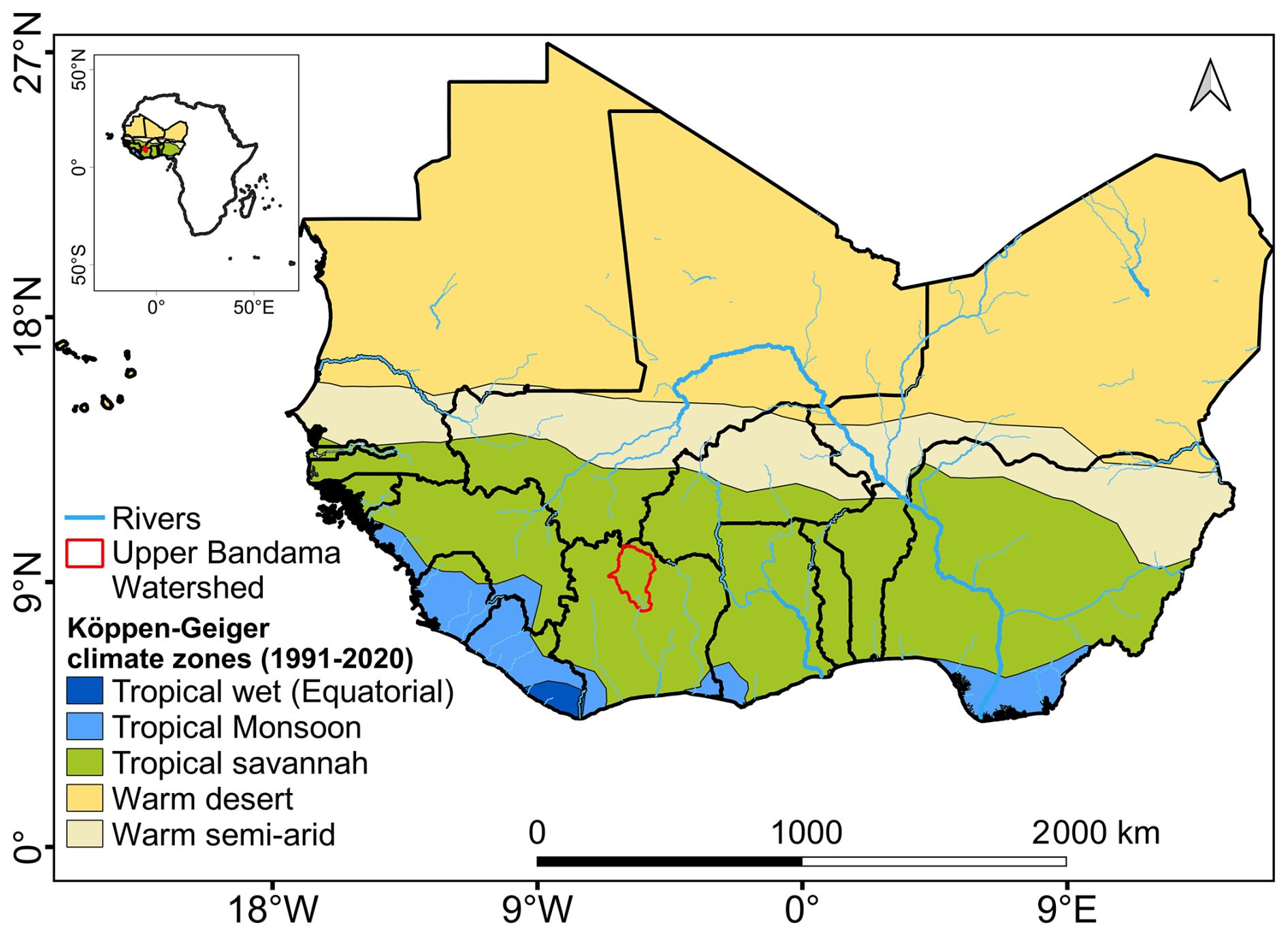
Figure 1West Africa, its Köpen-Geiger climate zones (Beck et al., 2023), and the location of the Upper Bandama Watershed.
The Upper Bandama (or Bandama Blanc) watershed, located in northern Côte d'Ivoire within the Sudanian climatic zone, was selected to evaluate the data quality. Covering approximately 14 500 km2 between 8°40′–10°20′ N and 5°00′–6°20′ W, the watershed is of key importance due to its position upstream of a major hydroelectric dam (Kossou dam). Moreover, small agricultural dams are prevalent in the area, and its rural population relies heavily on rain-fed agriculture for livelihoods and food security, making it particularly vulnerable to hydrological variability (Moussa Ouedraogo, 2016). The Upper Bandama watershed therefore provides a valuable benchmark and represents a data-scarce context where existing datasets often have limited coverage and is currently the only validation dataset available to us for this assessment.
2.2 Literature review and selection of dam and reservoir datasets for compilation
We carried out a literature review to identify, inventory, and assess the current state of existing datasets containing information on dams and reservoirs in West Africa. We consulted online scholarly literature datasets of peer-reviewed journal articles, theses and dissertations, books, conference papers, and technical reports. The online scholarly literature datasets used were Google Scholar (https://scholar.google.com/, last access: 30 September 2025) and SCOPUS (https://www.scopus.com/, last access: 30 September 2025). Search strings were defined using the keywords of this study such as dams, reservoirs, datasets, water management, and West Africa along with their synonyms, and related words to ensure comprehensive coverage of pertinent literature (Table 1). Based on this review, we selected datasets that are open-access with standardized file formats (CSV or XLS and SHP) for compilation (Fig. 2, Table 2). For each dataset, we used the most recent dataset version available at the time of the study and combined the versions when they are complementary. For instance, we combined two versions of the Global Lakes and Wetlands Database (GLWD) into a unified dataset by merging them: GLWD Level 1 (GLWD-L1) including large waterbodies (≥50 km2 for lakes and ≥0.5 km3 for reservoirs), and GLWD Level 2 (GLWD-L2), which includes smaller waterbodies.
Table 1Search strings used to carry out the literature review, along with details on search language, year of publications and type of online scholarly literature datasets consulted.
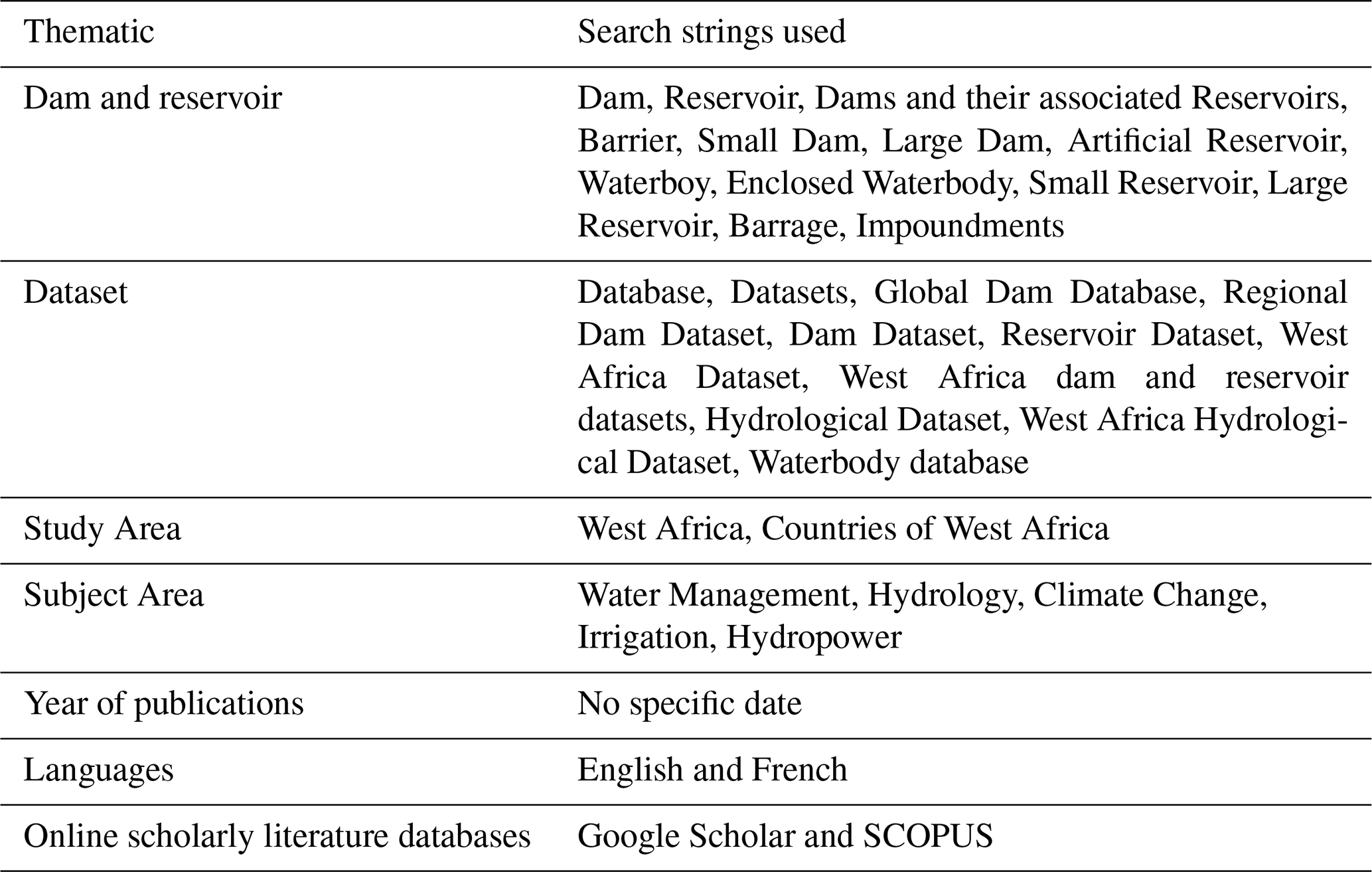
Table 2List of datasets selected to compile the West Africa dam-reservoir dataset.
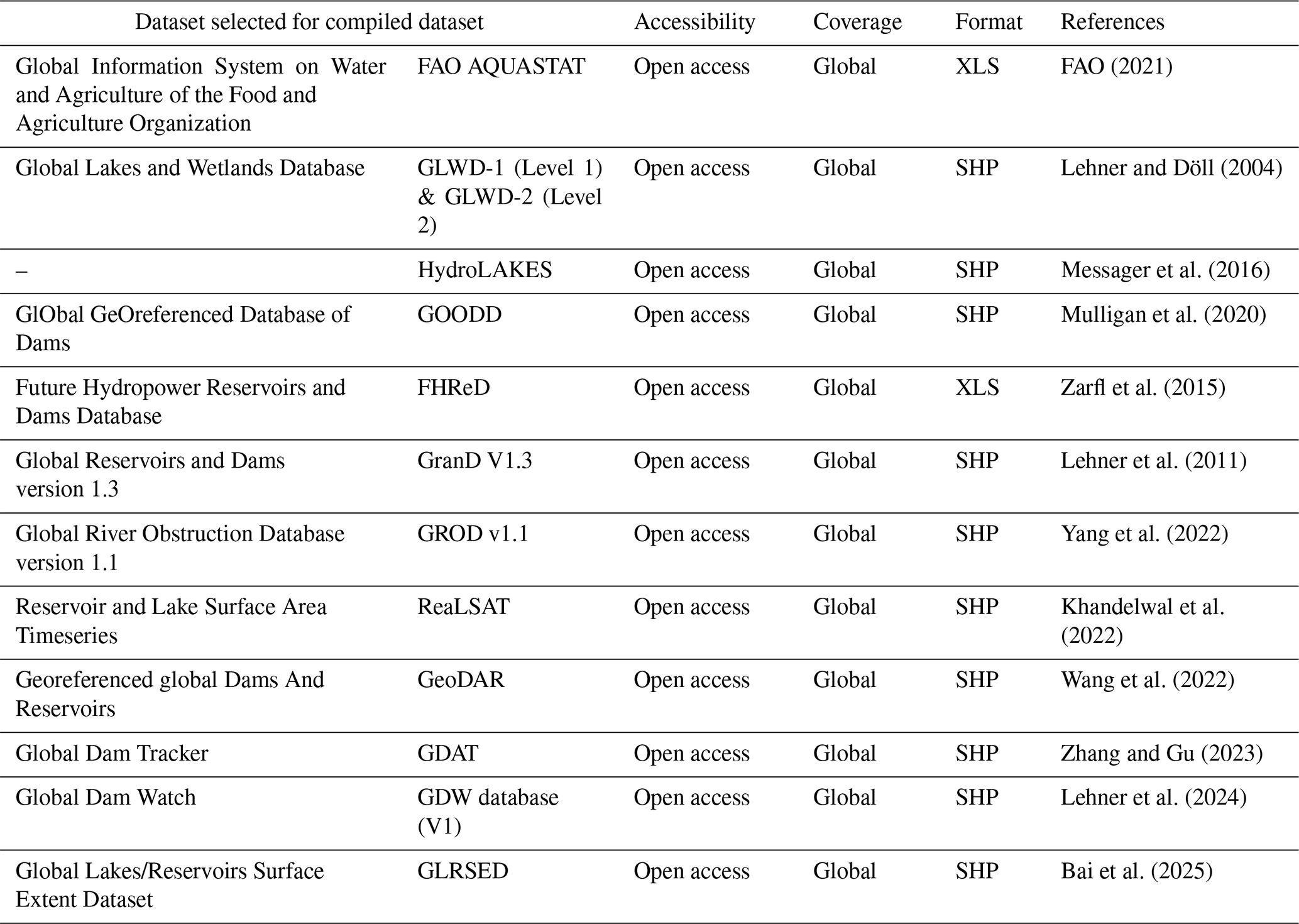
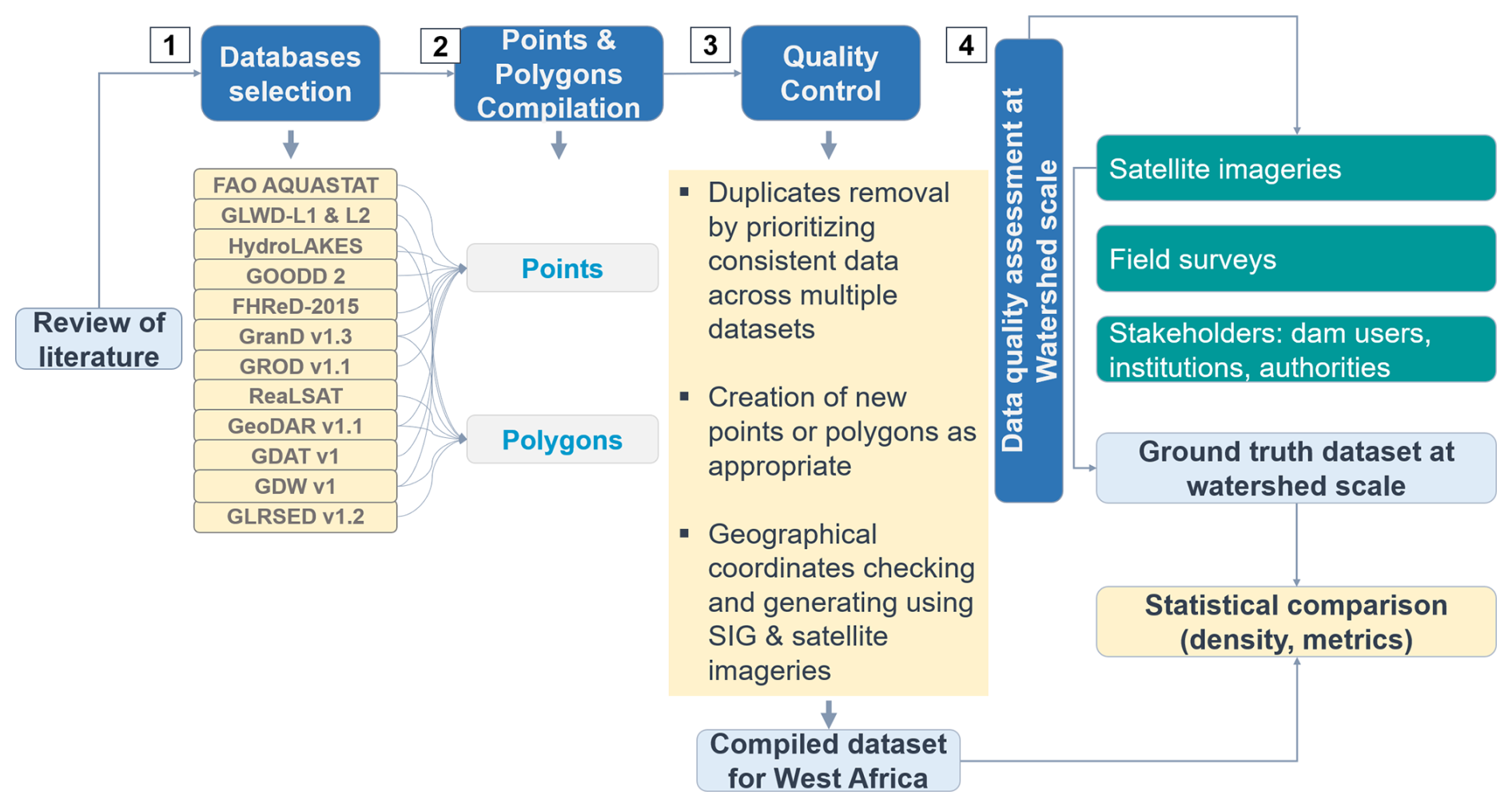
Figure 2Flowchart describing the methodological approach applied to develop the West Africa dam and reservoir dataset: (1) datasets selection through literature review, (2) compilation of point and polygon shapefiles from the selected datasets, (3) quality control of the compiled dataset, and (4) data quality assessment at watershed scale.
2.3 Compilation of selected datasets and quality control
We extracted the data related to West Africa from each dataset and compared their entry (feature) types (dams and/or closed waterbodies) and counts, the proportional (percentage) representation of West African entries, and their attribute types and records. We then merged dam point and waterbody polygon entries separately into unified shapefiles using the Quantum Geographic Information System software (QGIS version 3.28.3) (Moyroud and Portet, 2018).
We overlaid the two merged files (point and polygon files) on high-resolution satellite basemaps from ESRI Imagery and Google Earth. This was to verify and refine the spatial accuracy of dam and reservoir geographic coordinates and to digitize missing dam points or reservoir polygons as appropriate. Dam points and reservoir polygons do not always have a strict one-to-one relationship in the compiled dataset as the selected source datasets differ in their feature types and purposes. Some datasets provide dam locations as points only, while others provide reservoir polygons without associated dam points. In addition, some large or complex reservoir systems may include more than one dam-related point, while some small dams may not have a clearly mapped reservoir polygon in the available products. Where possible, we linked dam points to reservoir polygons using spatial overlay and proximity analysis in QGIS. A dam point was associated with a reservoir polygon when it was located within, on the boundary of, or immediately downstream of the polygon. This spatial matching was supported by attribute information where available, including dam or reservoir name, country, river or basin, reservoir area, and source dataset. We manually inspected ambiguous cases using the spatial layers and, where necessary, satellite imagery or base maps. The satellite images also enabled us to visually identify natural waterbodies such as rivers and lakes that were subsequently removed manually from the data. We only retained man-made reservoirs with dams.
Several original datasets may share common source information or inherit records from earlier datasets. We accounted for this issue mainly through duplicate identification and data-source tracking. We identified duplicate records using a combination of spatial and attribute-based checks. Records with identical or nearly identical geographic coordinates were flagged as potential duplicates. We visually inspected in QGIS, overlapping or very closely located features. Additionally, available attributes such as dam or reservoir name, country, river or basin name, reservoir area, storage capacity, construction year, and source dataset were compared to confirm whether the records referred to the same infrastructure. When duplicate records were confirmed, we retained only one representative record in the compiled dataset. Attribute information from the duplicate sources was not simply discarded; rather, consistent information was retained and used to improve the completeness of the final record. When attribute values differed across sources, we retained the most complete and consistent record and identified the primary contributing dataset in the source field of the compiled dataset.
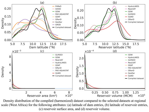
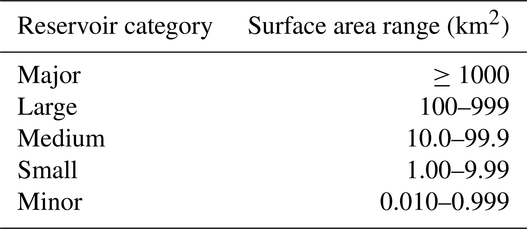
Finally, we assessed the differences between the newly compiled dataset and the original datasets (Sect. 2.2) at the West Africa scale by comparing the probability density distribution of attributes such as dam latitude, reservoir latitude, reservoir surface area, and reservoir volume. We estimated these distributions using Kernel Density Estimation (KDE), a widely used non-parametric method for probability density estimation (O'Brien et al., 2016). We defined the reservoir surface area classes based on the definition proposed by FAO (Table 3, Bernacsek, 1984). We classified minor and small reservoirs as “small-scale infrastructure” and medium, large, and major reservoirs as “large-scale infrastructure.” We further related dam size classes to the size class of their associated reservoirs. Accordingly, a small dam refers to a dam associated with a small reservoir.
Table 3Reservoir categories ranked according to the surface area of reservoirs (Bernacsek, 1984).
2.4 Assessment of data quality through a watershed scale ground truthing
The quality assessment of the dam and reservoir data at the watershed scale follows a structured, multi-step process designed to compare the compiled dataset with ground truth data. First, we consulted national institutions and agencies involved in studies related to dams and reservoirs in order to access their records. These institutions are the Geoscience & Environment Laboratory of Nangui Abrogoua University (UNA) in Côte d'Ivoire and the National Office of Technical Studies and Development (BNETD).
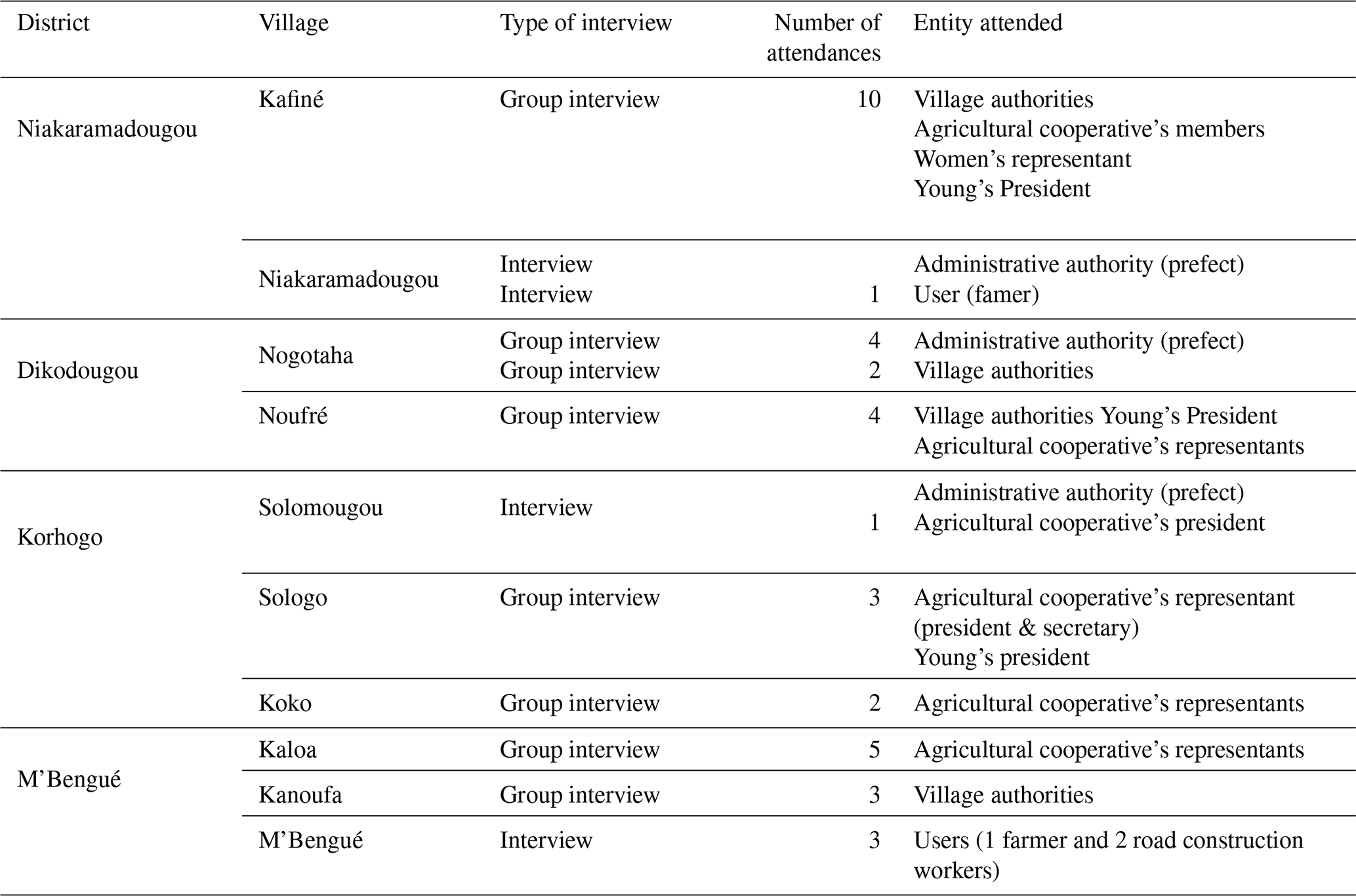
Next, we conducted field surveys during the dry season (December 2024) across the Upper Bandama watershed, which covers approximately 14 000 km2. Using a structured questionnaire (Appendix A, Fig. A1), we carried out group interviews with local communities in each village that hosts a dam, covering ten villages and four districts (county) in total: Niakaramandougou, Dikodougou, Korhogo, M'Bengué. Interview questions were focused on dam and reservoir characteristics (e.g. year of construction, main uses, existence or not of maintenance plan, reservoir surface and volume, potential number of users). Participants included traditional authorities, local dam management bodies, user cooperatives, women's and youth associations, and smallholder farmers (Appendix B, Table B1). This participatory approach ensures that the data reflects both technical accuracy and socio-environmental realities (Quimby and Beresford, 2023). Additionally, we recorded ground truth geographic coordinates of dams and their reservoirs using a GPS-enabled handheld device. It is important to note that the survey focused on dams and reservoirs identified through consultations with institutions, local authorities, and community members, and that were accessible by vehicle or on foot and therefore verifiable during field visits.
Data from the field and institutional sources were combined to form a ground truth dataset for the Upper Bandama watershed. This field campaign data (ground truth data) was then compared with the compiled dataset (Sect. 2.3) to evaluate how accurately the compiled dataset represents the spatial representation and the characteristics of constructed dams and their reservoirs. The comparison involved the probability of density distribution of attributes including latitude of dams, year of completion, reservoir volume, reservoir surface area, average reservoir depth, dam height, and average discharge (outflow). In addition, we determined the descriptive statistics (mean, median, root mean square error (RMSE), and interquartile range (IQR)) for each attribute to quantify the differences between the compiled dataset (Sect. 2.3) and the field campaign data for the Upper Bandama watershed.
3.1 Existing databases containing West African dam and reservoir data and their characteristics
The International Commission on Large Dams (ICOLD) has maintained and regularly updated the World Register of Dams (WRD) since 1958. The WRD is a comprehensive inventory of over 62 000 large dams (≥15 m in height or m3 in storage capacity) across 166 countries, of which two-thirds are georeferenced (ICOLD, 2024). The WRD has informed the development of several major global datasets, including the Global Lakes and Wetlands Database (GLWD) (Lehner and Döll, 2004). GLWD provides a global raster map with a 30 s resolution structured in three tiers: (1) 3067 large lakes (≥50 km2) and 654 large reservoirs (≥0.5 km3), (2) approximately 250 000 smaller waterbodies (≥0.1 km2), and (3) a classification of wetland type.
The Food and Agriculture Organization (FAO) incorporated data from the WRD and other sources, including national surveys and literature reviews, into the Global Information System on Water and Agriculture (AQUASTAT) (FAO, 2007, 2021). AQUASTAT provides detailed information on approximately 14 500 dams and their reservoirs, covering the geographic location, dam height, reservoir capacity, surface area, and primary purpose. This dataset contributed to the Global Reservoirs and Dams (GRanD) database, which supports integrated assessments of the environmental and socio-economic impacts of dams (Lehner et al., 2011). GRanD v1.1 contains 6862 records with a combined storage capacity of 6197 km3. In 2019, GRanD v1.3 added 458 additional reservoirs, bringing the total to 7320, and the earlier v1.2 which was not produced as a standalone product was integrated into the HydroLAKES v1.0 database (Lehner et al., 2011). These updates reflect the continued global growth of reservoir capacity, especially from projects completed between 2000 and 2016. Other relevant databases include the Future Hydropower Reservoirs and Dams (FHReD) database (Zarfl et al., 2015), which contains over 3700 planned or under-construction dams exceeding 1 MW in capacity. Mulligan et al. (2020) introduced the GlObal GeOreferenced Database of Dams (GOODD), which is containing over 38 000 dams identified through high-resolution satellite imagery, although with limited attribute information. The version 1.1 of the Global River Obstruction Database (GROD v1.1) by Yang et al. (2022) maps 30 549 artificial structures across 2.1×10⁶ km of large rivers using Google Earth Engine. Each structure is categorized into one of six types of flow barriers. Wang et al. (2022) developed the Georeferenced global Dams And Reservoirs (GeoDAR) dataset using Google Maps and other inventories including ICOLD WRD, GRanD v1.3, and HydroLAKES v1.0. GeoDAR v1.1 includes, in all continents except Antarctica, over 24 000 dam points and 21 500 reservoir polygons linked to high-resolution water masks. Zhang and Gu (2023) relied on AQUASTAT, GRanD, and the World Resources Institute (WRI) database to build the Global Dam Tracker (GDAT), which includes over 35 000 geocoded dams, suitable for temporal analysis. A recent consolidation effort by Lehner et al. (2024) harmonized datasets by releasing the Global Dam Watch (GDW v1), integrating GRanD, GOODD, and FHReD, and complemented by GROD and the EC Joint Research Centre's Global Surface Water dataset. GDW v1 contains 41 145 dam and barrier locations, and 35 295 reservoir polygons, with a total storage of 7405 km3.
In parallel, recent initiatives focused on global monitoring of waterbody surface dynamics and morphology which contain data about reservoirs in all continents (except Antarctica). Khandelwal et al. (2022) developed the ReaLSAT dataset using machine learning applied to Earth Observation data and compiled surface area variations of over 681 000 waterbodies (≥0.1 km2) from 1984 to 2015. Donchyts et al. (2022) monitored 71 208 small to medium-sized reservoirs globally using multi-sensor satellite data. Khazaei et al. (2022) introduced a novel GLObal Bathymetric (GLOBathy) dataset, which estimates bathymetry for over 1.4 million waterbodies using a GIS-based framework. Bai et al. (2025) produced the GLRSED, combining data from HydroLAKES and OpenStreetMap to provide detailed spatial and physical attributes for 2.17 million entries (features). We provided a summary of existing global databases containing data for West African dams and reservoirs in the following table (Table 4).
Table 4List of some existing databases containing West African dam and reservoir related data and their characteristics.
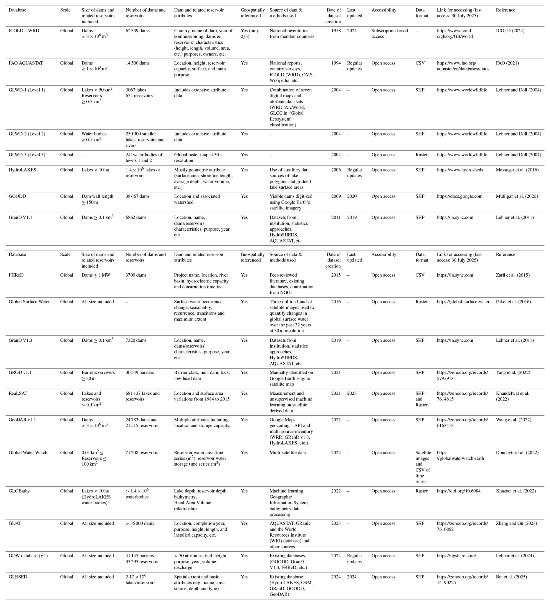
Databases are listed in order of their creation date.
3.2 Comparison of data on West African dams and reservoirs from selected datasets
3.2.1 Type of entries and their proportional representation for West Africa in selected datasets
The number of entries (dams, other barriers and any closed waterbodies) contained in the datasets varies between datasets. This also applies to the extent and detail of West African related entries (Fig. 3). The total entries counted in the selected datasets varies from 3700 to 2.17 million with FHRed containing the fewest records and GLRSED v1.2 holding the highest number of entries. The proportion of West African entries within the selected datasets is relatively low ranging from 0.19 % to 4.26 %. Despite the extensive global coverage of GLRSED, only 0.26 % of its entries correspond to West Africa. These clearly reflect the differences between the existing datasets regarding the total number of entries recorded for West Africa (Fig. 4). These differences are also observable at the level of the entry types in selected datasets. According to the type of their entries, the datasets can be grouped into four categories:
-
Dam-only datasets, including various barrier types (e.g., FAO AQUASTAT, GOODD 2, FHReD, GROD v1.1, GDAT);
-
Integrated dam-reservoir datasets providing information on both infrastructure and associated waterbodies (e.g., GranD v1.3, GeoDAR v1.1, GDW v1);
-
Combined lakes and reservoirs datasets (e.g., GLWD-L1 & L2, HydroLAKES, GLRSED v1.2);
-
Unspecified waterbody datasets where natural lakes, artificial reservoirs, and other surface waters are grouped without classification (e.g., RealSAT).
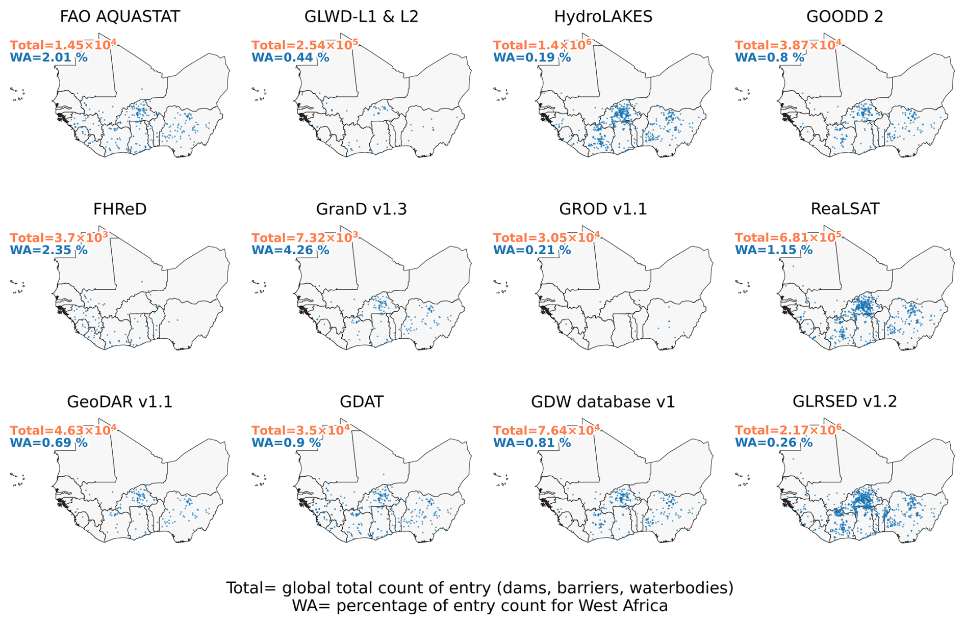
Figure 3Comparison of global total count of entry (dams, other barriers, and closed waterbodies) and the corresponding proportion (percentage) of West African entries in selected datasets.
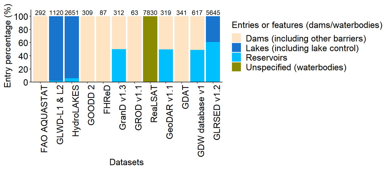
Figure 4Entry types, total counts, and proportion (%) of each entry for West Africa in selected datasets. The term “lake control” refers to a natural lake that is influenced or regulated by a control structure, such as a dam or outlet regulation structure.
3.2.2 Type of available attributes for the selected datasets
A wide range of attributes for West African dams and reservoirs is included in the available datasets and varies across the datasets (Table 5). This encompasses:
-
Identification data: Name of dam or reservoir, geographic coordinates, country, continent, administrative unit, and year of construction;
-
Geometric data: Dam or barrier height and length, reservoir surface area, storage volume, and average depth;
-
Purpose-related data: Designated uses such as irrigation, hydroelectric power generation, livestock watering, and flood control;
-
Hydraulic and hydrological data: Inflow, discharge (outflow), water residence time, and sedimentation characteristics.
Table 5Attribute types (identification, geometry, purpose, and hydraulic and hydrological data) available in selected dam and reservoir datasets. The cross in the cells indicates the availability of the attribute type in the dataset.
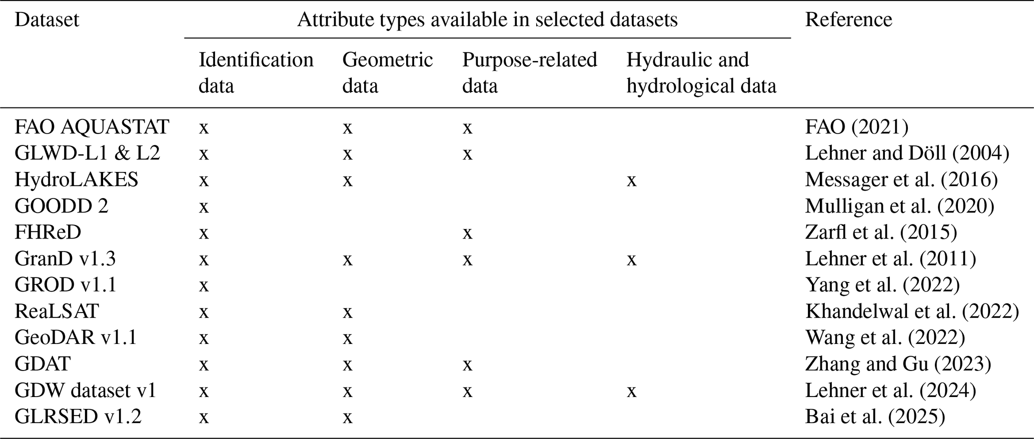
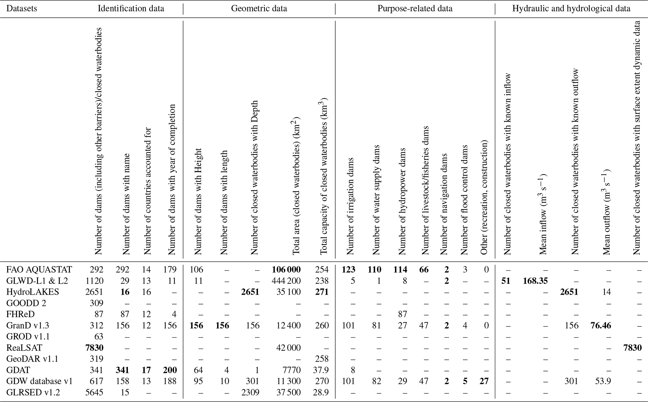
Although some attributes appear to be common across the datasets, clear differences exist in the number of information recorded. We outlined these differences by providing a comparative overview of attribute types and completeness across selected datasets for West Africa (Table 6). FAO AQUASTAT dataset reports the largest total surface area of reservoirs and the highest number of dams categorized by use. HydroLAKES covers the most West African countries and reports the highest total storage capacity. RealSAT contains the largest number of entries and is unique in providing data on the dynamics of water surface bodies and GDAT includes the highest number of entries with names and years of completion.
Table 6Comparison of attribute type details and data completeness in selected dam and reservoir datasets for West Africa. Bold values represent the highest column values.
3.2.3 Methodological differences and limitations in existing dam and reservoir datasets
Selected datasets can be grouped into three categories based on the methods applied to collect data on dams and reservoirs: remote-sensing driven datasets, curated inventory datasets and hybrid datasets.
Remote-sensing driven datasets (e.g., GLRSED v1.2, ReaLSAT, GROD v1.1) are collected in real-time or near-real-time using optical or radar satellite imagery (e.g., Landsat, Sentinel-1/2, MODIS), automated classification, and time-series water detection algorithms (Khandelwal et al., 2022; Bai et al., 2025). These datasets can provide detailed measurements of parameters of dam and reservoir entries such as water levels and flow rates at a high spatial and temporal resolution and can track small, ephemeral, or seasonally variable waterbodies. They are particularly useful for monitoring and managing dynamic systems, allowing for timely responses to changes (Donchyts et al., 2022; Kachoue et al., 2024). Limitations are that accuracy can be affected when high-resolution imagery is not available or when distinguishing between man-made and natural waterbodies (Khandelwal et al., 2022; Bai et al., 2025).
Curated inventory datasets (e.g., GLWD, FAO AQUASTAT, GeoDAR v1.1, GDAT, FHReD, GDW Database v1) are typically more static datasets that compile information from multiple sources, focusing on larger-scale entries and providing broad coverage of dam and reservoir attributes (Zarfl et al., 2015; FAO, 2021; ICOLD, 2024). These datasets standardize attributes, enhance accessibility and usability, and support decision-making for water management across larger spatial and temporal scales (Lehner et al., 2024). Meanwhile they may lag in representing newly constructed dams or recent environmental changes if not regularly maintained (Zarfl et al., 2015; FAO, 2021; Wang et al., 2025). In addition, small reservoirs and informal structure can sometimes be overlooked or inaccurately georeferenced due to the methods of data collection used, such as manual georeferencing or inconsistencies in attribute reporting (Paredes-Beltran et al., 2021; Minocha and Hossain, 2025).
Hybrid datasets (e.g., HydroLAKES, GOODD 2, GRanD v1.3) combine remote-sensing data for mapping with curated inventory data for metadata, leveraging the strengths of each to enhance the overall quality and comprehensiveness of dam and reservoir information (Lehner et al., 2011; Messager et al., 2016; Mulligan et al., 2020). However, hybrid datasets may be limited by inherent variability in data quality originating from the different sources involved in their compilation. The complexity of merging static data from curated inventory with dynamic datasets derived from remote sensing associated to mismatches in format, scale, and temporal resolution can lead to additional errors in analyses or even misinterpretations (Lehner et al., 2011; Song et al., 2022).
3.3 Compiled dataset for dams and reservoirs in West Africa
3.3.1 Description of the compiled dataset and data characteristics
The dataset that we compiled based on the selected twelve datasets contains a total of georeferenced 1429 dam points and 1258 reservoir polygons ( km2 and ≥0.1 m3). Compared with the individual source datasets, the compiled dataset adds 1088 to 1415 dam entries and 117 to 1119 reservoir entries, depending on the dataset considered (Fig. 5). Among the originate datasets, GLRSED contributed the largest share of reservoir records, accounting for 91 % of the reservoir entries in the compiled dataset, whereas GDAT contributed the largest share of dam records, accounting for 24 % of the dam entries. In terms of attribute completeness, the compiled dataset provides thirty-eight attributes. All dam entries have known geographic coordinates and country identifiers. Approximately 88 % of dam entries are linked to a delineated reservoir polygon, and 80 % contain information on the estimated reservoir surface areas. Furthermore, around 40 % of dam entries provide additional physical characteristics such as reservoir average discharge, reservoir storage capacity, mean depth, average slope, and watershed area. In contrast, metadata attributes including dam names, year of construction, major river basin, primary use, and river name are less consistently available, occurring in fewer than 20 % of dam entries (Fig. 6).
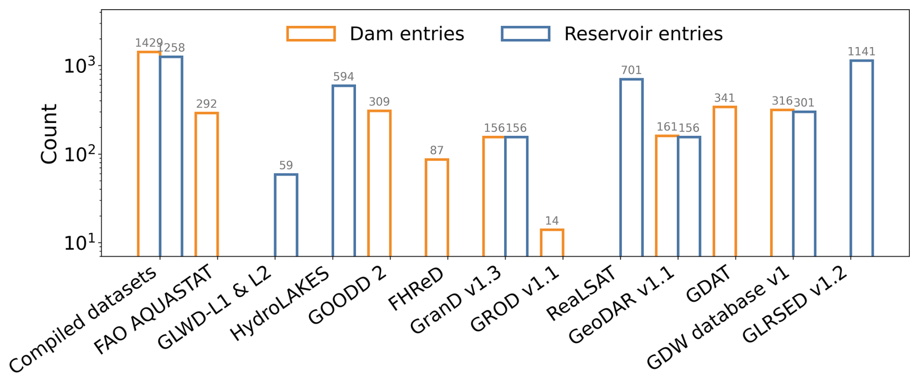
Figure 5Comparison of dam and reservoir (without any other type of barrier and closed waterbody) entry count between the compiled dataset and selected datasets.
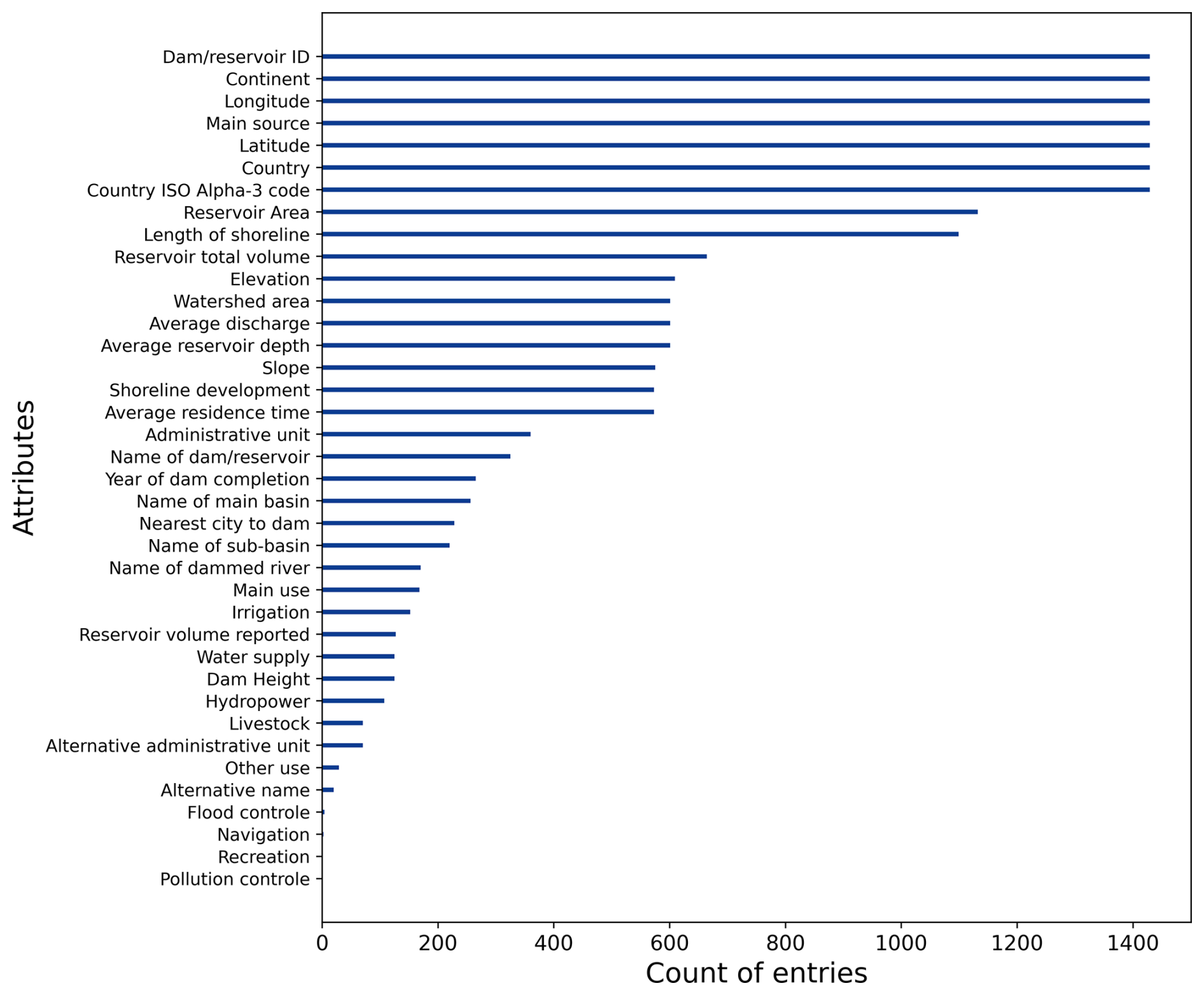
Figure 6Attribute completeness for the 1429 dams and their reservoirs from the compiled dataset for West Africa.
3.3.2 Spatial distribution of dams and associated reservoirs over West Africa
The spatial distribution of dams and reservoirs reported from the compiled dataset, is highly uneven across West Africa. A notable concentration is observed in Burkina Faso with 489 recorded dams (Fig. 7a). Ghana follows with 236 dams, while Guinea-Bissau stands out as the only country with no recorded dam and reservoir (Fig. 7b). Overall, the total surface area of artificial reservoirs reported from the compiled dataset is estimated at 14 038 km2 (Fig. 7c). The two largest reservoirs by surface area are located in Ghana and Nigeria, namely, the Akosombo Reservoir (6019.49 km2) and the Kainji Reservoir (1034.85 km2). Medium-sized reservoirs are more evenly distributed across the climatic zones of West Africa, whereas small-scale infrastructure composed by minor and small reservoirs are more commonly found in the Sudanian savannah (northern of Côte d'Ivoire, Ghana, Togo, Benin, and Nigeria) and in the semi-arid zone of Burkina Faso. In terms of water volume, the storage capacity totalled approximately 2.83032×10¹¹ m3 for all dam reservoirs from the compiled dataset (Fig. 7d). However, this storage capacity is far from evenly distributed. Ghana alone accounts for 1.48671×10¹¹ m3, representing 52.53 % of the region's total. Nigeria follows with 4.16584×10¹⁰ m3 (14.72 %), Côte d'Ivoire with 3.82091×10¹⁰ m3 (13.5 %), and Mali with 1.36152×10¹⁰ m3 (4.81 %). Interestingly, although Burkina Faso has the highest number of dams, it represents only 2.4 % of the total regional storage capacity reported from the dataset. This contrast highlights the difference between the abundance of dam infrastructure and the relatively limited water storage volume these structures represent, which is influenced by the south-north aridity gradient across West Africa.
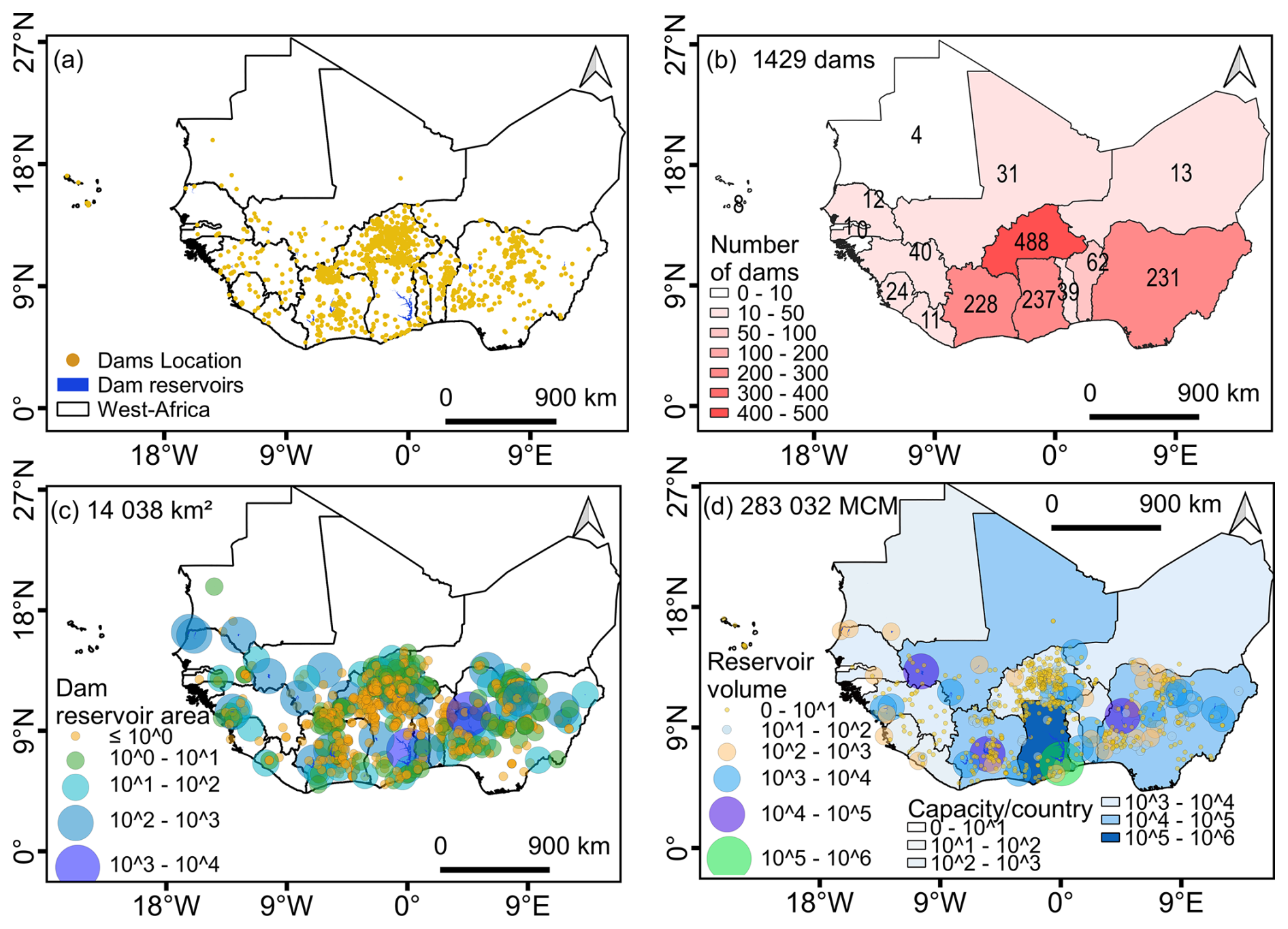
Figure 7Spatial distribution and summary characteristics of 1429 dams and their reservoirs in West Africa. (a) Locations of dams and mapped reservoirs, (b) number of dams per country, (c) reservoir surface area (totalling 14 038 km2) classified based on the definitions proposed by FAO (Bernacsek, 1984), and (d) estimated storage capacity by reservoir and aggregated per country (totalling 2.83032×10¹¹ m3).
3.3.3 Temporal changes in dam numbers and latitudinal distribution
The temporal distribution of dam construction reported from the compiled dataset shows that the annual number of constructed dams peaked in 1985 in West Africa, with the oldest constructed dam dating back to 1881 (the Kpong dam in Ghana) (Fig. 8a). Spatially, the distribution of dams and their associated reservoir reflects distinct climatic gradients across the region and can be divided into three main zones (Fig. 8b). In the southernmost zone (6–8° N), corresponding to the humid tropical Guinean coastal region, the number of dams is relatively low, yet the reservoirs are generally associated with large reservoir surface areas. Further north, between 8 and 14° N, encompassing the sub-humid Sudanian savannah and the semi-arid Sahelian zones, dam density increases markedly, with most reservoirs exhibiting small to medium surface areas. North of 14° N, the northern limit of the Sahelian zone, the number of dams declines sharply, with only a few isolated structures recorded.
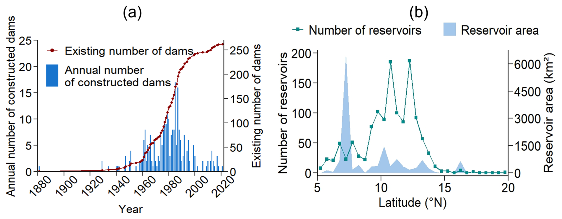
Figure 8Temporal and spatial distribution of constructed dams and their reservoirs in West Africa. (a) Temporal changes in dam construction reported from the compiled dataset, (b) latitudinal distribution of reservoirs showing the number of reservoirs and their corresponding surface area per latitude.
3.3.4 Comparing spatial and size-class densities in compiled and selected datasets in West Africa
Across the existing datasets and the compiled dataset, dam and reservoir locations exhibit consistent latitudinal modes between approximately 9–13° N. The long right tails for the reservoir surface area and volume appearing in most datasets, reveals a consistent representation of large infrastructure (Fig. 9). However, density peaks at the very small entries vary widely across datasets reflecting strong differences in counts and distributions of small infrastructure (Fig. 9c, d). Additionally, differences in reservoir size distributions, including surface area and volume, indicate contrasting dataset biases. Remote sensing driven and hybrid datasets (e.g., GLRSED v1.2, ReaLSAT, HydroLAKES) predominantly capture smaller scale infrastructure. In contrast, curated inventory datasets (e.g., GLWD L1 and L2, FAO AQUASTAT, GeoDAR v1.1, GDAT) are biased toward larger dams and reservoirs. Broader or shifted latitudinal tails and variations in density magnitude, represented by line heights, across datasets imply strong differences in regional completeness and geolocation practices. As a result, even when the main spatial patterns are consistent, the number of reservoirs detected, particularly at the northern and southern edges, differs substantially between datasets (Fig. 9c, d). Compared to existing datasets, the compiled dataset integrates both large- and small-scale reservoirs. It includes a higher number of small-scale entries while preserving the central latitude mode observed in the selected datasets. This suggests better spatial completeness and scale coverage compared to individual datasets, although residual biases from the sources remain in the compiled dataset.
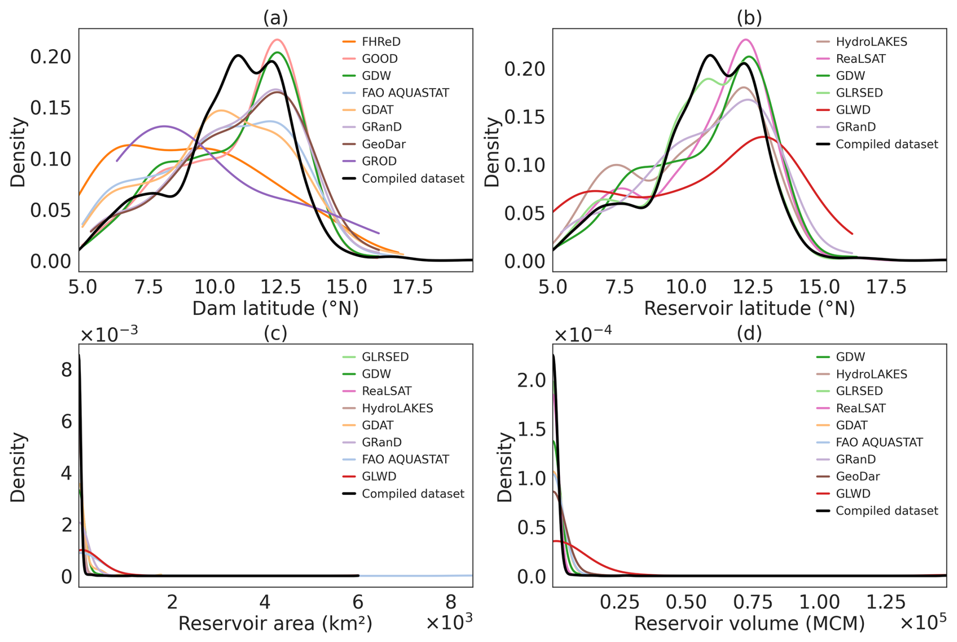
Figure 9Density distribution of compiled dataset compared to the selected datasets at regional scale (West Africa) for the following attributes: (a) latitude of dam entries, (b) latitude of reservoir entries, (c) reservoir surface area, and (d) reservoir volume.
3.3.5 Benchmarking of the compiled dataset at a watershed-scale for quality assessment
The field campaign dataset (ground truth dataset) obtained at watershed scale (the Upper Bandama watershed) contains 192 dam entries with each dam entry corresponding to a matching reservoir entry. The compiled dataset contains 62 dams with associated reservoirs in the Upper Bandama watershed, all confirmed by the field campaign data, accounting for 32 % of the dams documented during field campaign (Fig. 10). In addition, the compiled dataset records a total maximum reservoir area of approximately 31 km2 and a total storage volume of 2.07×10⁸ m3 for the Upper Bandama watershed, compared with 50 km2 and 3.52×10⁸ m3, in the field campaign dataset. The compiled dataset therefore captures about 62 % of the total reservoir area and 59 % of the total storage volume reported from field campaign. After the field campaign, more detailed data was available for the different attributes relative to the available data from the compiled dataset (Fig. 11). The analysis of the density distribution (KDE) of the attributes for both datasets indicates reduced outliers and a concentration of values within more plausible ranges in the field campaign data (Fig. 12). While the number of dams is different between both datasets, the latitudinal distribution of dams is consistent and peaks around 9.50° N (Fig. 12a). The low root mean square error value (RMSE =0.53) of the compiled latitudes indicates a very low deviation in the geographical information of the compiled dataset (Table 7). The different distribution of the year of dam completion clearly shows that current available datasets have a bias towards older dams, while the field campaign also accounted for newer infrastructure (Fig. 12b, Table 7). Overall, the current available datasets may underrepresent newer infrastructure by approximately 8 years on average. Additionally, the field data clearly deviated from the compiled dataset in terms of reservoir surface area and storage volume (Fig. 12c, d), with the existing datasets strongly underrepresenting small- and med-sized reservoirs. These differences are associated with high RMSE values (2.79 km2 and 1.744×10⁷ m3) reflecting high deviation in reservoir surface area and storage volume of the compiled dataset (Table 7). Differences in average depth and discharge were much less pronounced between what the compiled dataset showed for the Upper Bandama and what the field campaign and data collection revealed (Fig. 12e, g). However, the few samples on larger streams might have biased the tailing, which may have resulted in higher errors in the discharge values (RMSE = 15.85 m3 s−1). Consistent with the revealed smaller reservoir area and storage sizes, the field-based survey revealed much smaller dams (in terms of height) compared to the data compiled from existing datasets (Fig. 12f).
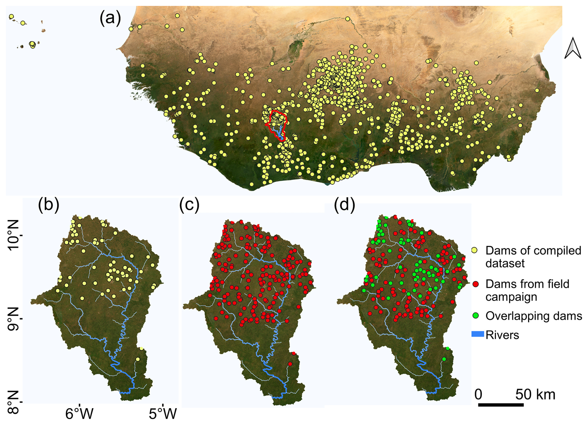
Figure 10Comparison of dam distributions from the compiled dataset and field campaign at watershed scale. (a) Spatial distribution of dams across West Africa from the compiled dataset. (b) Map of the 62 dams contained in the compiled dataset for the Upper Bandama watershed (14 000 km2). (c) 192 dams documented during the field campaign (ground-truth data). (d) Spatial overlap between dams in the compiled dataset and those documented during field campaign. Background image source: Esri imagery base map.
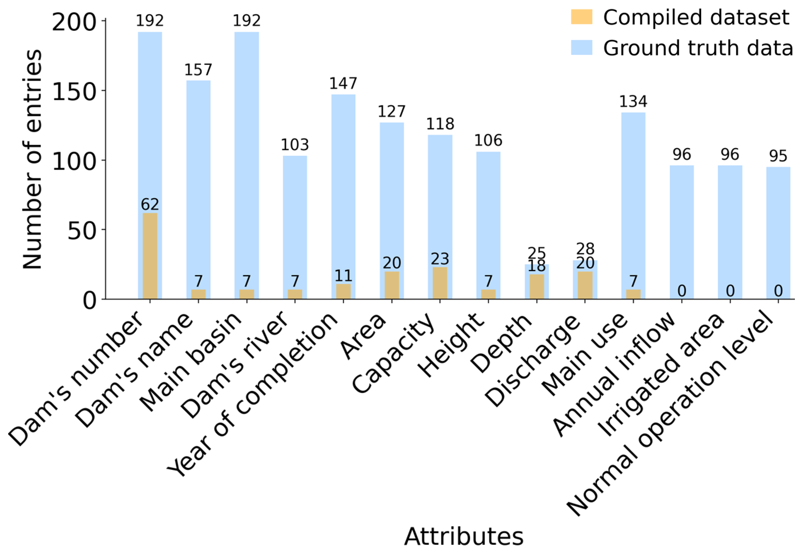
Figure 11Comparison of the number of entries for different attributes reported from the compiled dataset and the field campaign data (ground truth data) at watershed scale.
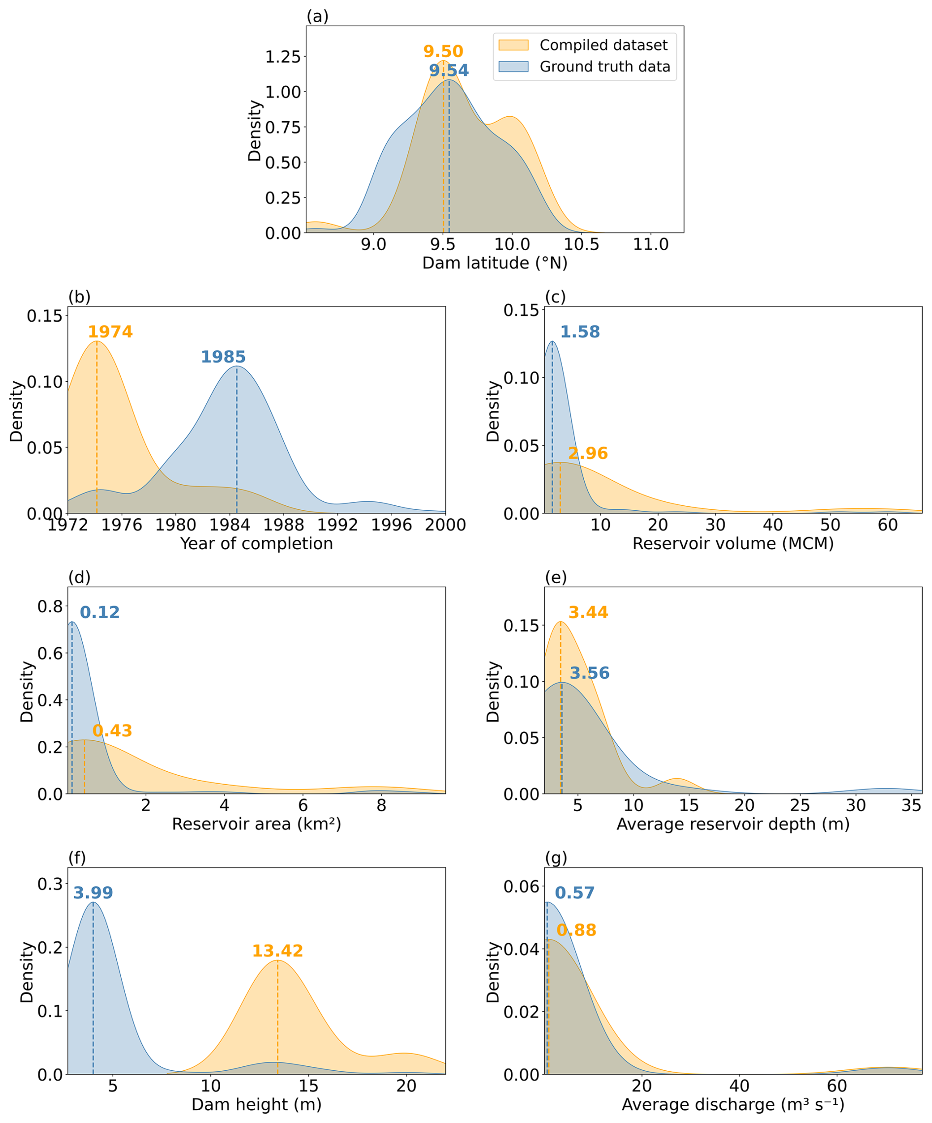
Figure 12Comparison of the density distribution of attributes from the compiled dataset and the field campaign dataset (ground truth data) at watershed scale (14 000 km2). This does not represent a one-to-one comparison of the same dams, but rather compares the overall attribute distributions in both datasets. The attributes shown are: (a) latitude, (b) year of completion, (c) reservoir volume, (d) reservoir surface area, (e) average reservoir depth, (f) dam height, and (g) average discharge.
Table 7Statistical comparison of compiled and field campaign (ground-truth) data for dam latitude, year of completion, reservoir volume, reservoir area, average reservoir depth, dam height and average discharge at watershed scale.
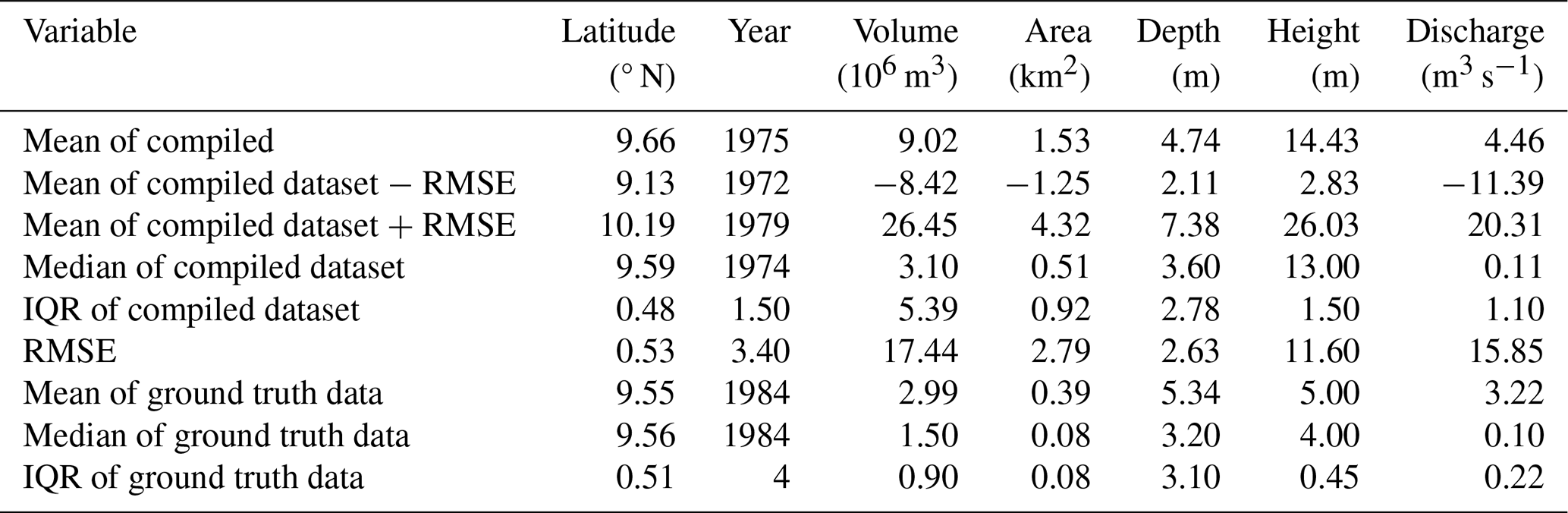
RMSE: Root mean square error, IQR: Interquartile range
4.1 Differences between existing datasets and quality of compiled dataset for West Africa
The comparison among existing dam and reservoir datasets highlighted substantial differences, particularly in spatial resolution, entry types (dams and/or reservoirs), and attribute completeness. These differences reflect to the heterogeneity of data sources, reporting standards, geographical focus, the dynamic nature of dam and reservoir operations, and variation in data collection approach and dataset objectives (Zarfl et al., 2015; Zhang and Gu, 2023; Bai et al., 2025). Such discrepancies have critical implications for future mapping efforts and research in Earth system sciences, including hydrology, climatology, and land-surface processes. In particular, they can lead to substantial uncertainty in estimates of surface water storage, flow regulation, evaporation losses, and human water use, especially in data sparse regions such as West Africa, highlighting the urgent need for standardized, high-resolution, and systematically validated datasets.
The ground truthing assessment showed that only 32 % of the field observed dams (with their associated reservoirs) were contained in the compiled dataset for the Upper Bandama watershed corresponding to a gap of 68 %. This result support the findings in Zhang and Gu (2023) that revealed a low proportion of West African dams in existing datasets and emphasized that publicly available dam-related data for much of Africa (except South Africa) remain limited due to restricted access and scarce reporting from national institutions. Complementary findings by Cecchi et al. (2020) suggest that water infrastructure development in the region has largely focused on small scale systems, such as minor earth dams and farm reservoirs. These small scale structures are often constructed informally or at the community level (e.g., for community irrigation or livestock) without official documentation limiting their inventory (Brewitt and Colwyn, 2020; Hennig et al., 2023; Umukiza et al., 2023). The bias of the compiled dataset toward large scale dams and reservoirs is inherited from source datasets that primarily capture well-documented, officially reported, or remotely detectable large dams, which typically have long operational histories and broader geopolitical or hydrological significance (Biswas and Tortajada, 2001; Lehner et al., 2011; Schulz and Adams, 2019; Hennig et al., 2023; ICOLD, 2024). In addition, the use of moderate-resolution satellite imagery (e.g., 30 m) in most datasets limits the detection of small dams and their reservoirs (Pekel et al., 2016; Mulligan et al., 2020; Yang et al., 2022). Consequently, the combined limitations of documentation and detection technologies result in the underestimation of small dams and reservoirs in remote sensing-driven, curated inventory and hybrid datasets.
The spatial pattern derived from the compiled dataset revealed a pronounced concentration of dams and reservoirs between 8 and 14° N, corresponding to the Sudanian zone. This is consistent with previous studies (Cecchi et al., 2009b; Lèye et al., 2021; Fowé et al., 2023) and reflects long-term efforts to mitigate rainfall variability and sustain agricultural productivity in the savannah biome (Cecchi et al., 2009a; Lèye et al., 2021; Fowé et al., 2023; Peña-Angulo et al., 2025).
Similar to other regional compilations (Paredes-Beltran et al., 2021; Song et al., 2022) the compiled dataset for West Africa contains fewer missing entries and exhibits lower bias compared to the originate datasets. This advances the existing efforts by explicitly integrating both large and small scale reservoirs. The compiled dataset reduces spatial and attribute biases observed in individual datasets and improves the characterization of cumulative reservoir presence and distribution. This improvement is critical for regional hydrological modeling, water balance assessments, and climate land surface interactions analyses. In addition, a more balanced representation across latitudinal gradients further enhances the suitability of the compiled dataset for basin scale and regional analyses. By filling the gap between global scale inventories, this dataset provides a regionally optimized foundation for future mapping and model calibration. It also supports scenario-based assessments of dam and reservoir impacts in West Africa. However, the gaps between the compiled dataset and the ground truthing data may still have important implications for water management and Earth system science research.
4.2 What do the gaps between the compiled dataset and ground truthing data imply for research and water management?
The limited representation of smaller and recently constructed infrastructure, as well as gaps in associated attributes at the watershed scale, reflects structural limitations in existing dam and reservoir datasets when applied to the West African region. Further, numerous studies reported the existence of several thousand dams and reservoirs in West Africa (Cecchi et al., 2009b; Jeppe Kolding, 2016; Abobi and Wolff, 2020; Lèye et al., 2021). Yet, there is still no consensus on their total number which underscores a need for additional surveys ground-based or remotely to supplement the existing data.
Reservoirs play a crucial role in shaping hydrological processes by regulating runoff, energy balance, and water availability (Eslamian et al., 2018; Hou et al., 2022). Through their alteration of natural river flows, they exert important influence on surrounding ecosystems, agricultural productivity, and water management strategies (Kaup, 2015; Latrubesse et al., 2017). The compiled dataset accounts for 62 % of the total reservoir area and 59 % of the total storage volume reported from field campaign at watershed scale (Upper Bandama watershed). Such data gaps in dam and reservoir inventories can introduce considerable bias into hydrological and land surface analyses, resulting in misestimation of key parameters such as runoff, water storage capacity, and evapotranspiration, energy and ultimately affecting water availability estimates (Lehner et al., 2011; Helfer et al., 2012; Lehner and Grill, 2013; McManamay, 2014; Joseph et al., 2018). Dang et al. (2020) showed that models excluding reservoirs can reproduce observed streamflow by compensating through parameter adjustments, resulting in biased representations of key hydrological processes such as surface runoff, infiltration, and baseflow. These structural deficiencies may remain hidden during model calibration. However, they become evident when the models are applied to climate change impact assessments. In such cases, projections of low, mean, and high flows differ substantially from those produced by models that explicitly represent reservoirs. Such discrepancies highlight the importance of incorporating a better representation of dams and reservoirs to ensure physically realistic simulations and robust future water resource and fluxes assessments.
In semi-arid regions where communities depend heavily on reservoirs for water supply, inaccuracies in estimating storage capacity or spatial distribution can misguide water allocation decisions and undermine policy planning (Zogheib et al., 2018; Ekka et al., 2024). For instance, in the Volta Basin, mismanagement and incorrect estimation of available water resources have hindered equitable allocation among stakeholders (Youkhana and Laube, 2009). The competing demands for water between agricultural, domestic, and industrial uses have led to conflicts among different water users when actual water availability does not meet anticipated allocations (Youkhana and Laube, 2009). Therefore, in data-scarce regions such as West Africa, the use of these datasets requires balancing trade-offs between spatial resolution, completeness, accessibility, uncertainty in available water, and reliability.
Users of the compiled dataset should be cautious of not only the inherited errors from sources but also the potential errors stemming from the compilation process such as human errors and bias-trade-off decisions when resolving conflicting attribute values (Kopperud et al., 2019; Song et al., 2022; Wang et al., 2022; Ye et al., 2023). These issues can amplify uncertainty in available water estimates in model predictions and other downstream applications, underscoring the importance of transparent error reporting and continuous data validation.
4.3 So what could we do to capture small scale and new dams and reservoirs more effectively?
Enhancing the quality and completeness of data on small sacle and recently constructed dam and reservoir in West Africa requires coordinated efforts that combine field validation, participatory approaches, and technological innovation. The ground-truthing of dam and reservoir data at watershed scale in this study revealed a much higher number of small infrastructures than recorded in the compiled data. This outcome highlights the importance of participatory mapping in identifying informal or community-built reservoirs that are often absent from official records. Expanding such participatory approaches to a regional level would improve data coverage and consistency (Rahman et al., 2025). This could be achieved by promoting open data policies across West African countries, ensuring the official publication of national inventories, and strengthening regional collaboration through basin organizations and water management authorities. Incorporating data-sharing requirements into donor-funded water projects would encourage regular updates and reduce data fragmentation. Moreover, establishing formal mechanisms for continuous dataset updates, supported by transparent exchange among national agencies and research institutions, would also help ensure that newly constructed or modified reservoirs are promptly included. Lastly, future research should focus on integrating field-based and participatory data with high-resolution satellite imagery, drone surveys, and machine-learning-based detection methods (Jing et al., 2021; Utama et al., 2024; Wang et al., 2025). Such a combination would enhance the detection and documentation of small and newly constructed dams and reservoirs, contributing to a more complete and up-to-date representation of water infrastructure across West Africa.
4.4 Limitations of the compiled dataset and future improvements
Despite the harmonization of dam and reservoir data in West Africa, the compiled dataset remains subject to several limitations. The quality assessment relied on field observations from a single watershed. Although this watershed scale comparison represents an important step toward validating existing datasets against locally observed information, the Upper Bandama watershed cannot capture the full diversity of environmental, hydrological, institutional, and data-availability conditions across West Africa. The performance of the compiled dataset may therefore differ in other climatic regions, river basins, and administrative contexts. Moreover, the field-reference dataset may itself be incomplete because some informal, inaccessible, recently constructed, or locally unreported dams could not be identified during the survey. These limitations introduce uncertainty into estimates of omission and dataset accuracy. Future assessments should include additional watersheds across the Guinean, Sudanian, and Sahelian climatic zones.
It is also important to note that the original datasets used in the compilation are not fully independent. Many of these datasets overlap, incorporate information from earlier inventories, or use similar remote-sensing products and mapping procedures. Consequently, agreement among multiple sources does not necessarily represent independent confirmation of a record. Additionally, the source field in the compiled dataset should be interpreted cautiously. It identifies the primary contributing source retained during harmonization rather than providing a complete record-level provenance history of all datasets that contributed information to a given dam or reservoir. Future versions could strengthen data traceability by recording all contributing sources, documenting attribute-level provenance, and assigning confidence scores based on source agreement, spatial accuracy, and attribute completeness.
Several attributes remain incomplete or uncertain. Reservoir surface area, storage capacity, watershed area, construction year, dam height, and other management-related characteristics are unavailable for some records. Missing values limit regional comparisons and may introduce bias because larger and formally managed infrastructure is generally better documented than small or informal structures. Differences in measurement methods, observation dates, spatial resolution, and definitions across the original datasets may also reduce the comparability of attribute values. Future work should establish standardized procedures for estimating missing reservoir areas and volumes, delineating upstream watersheds, and quantifying the uncertainty associated with derived attributes.
The Harmonized Dataset for Dams and Reservoirs in West Africa also called West Africa Dam and Reservoir Dataset (Kouassi et al., 2026) is freely accessible in CSV files and shapefiles (dam points and reservoir polygons) for download and updates via https://doi.org/10.60507/FK2/YLDK1Y under the https://creativecommons.org/licenses/by/4.0/ (last access: 22 January 2026) license.
This study provides insights into currently available datasets for dam and reservoir management in West Africa while presenting a new, region-specific dataset from the consolidation of existing sources. We identified nineteen datasets containing West African dam and reservoir information and which are widely reported in the literature. These datasets depict differences and limitations in terms of entry types (dams, other barriers and closed waterbodies), spatial resolution, percentage of West African data, attribute types and completeness, and data sources (remote sensing-driven, curated inventory and hybrid data).
From these, we integrated twelve datasets to improve access to data in West Africa, resulting in a more comprehensive and unified regional dataset with enhanced representation of the infrastructure. The compiled dataset includes thirty-eight attributes, and 1429 dam points and 1258 reservoir polygons. Compared with the original datasets considered individually, the compiled dataset adds between 1088 and 1415 dam entries and between 117 and 1119 reservoir entries for West Africa.
We assessed the quality of the compiled dataset against field campaign data at watershed scale (14 500 km2, in the Sudanian savannah) and validated through stakeholder engagement. The compiled dataset showed strong spatial and temporal consistency while counting for 32 % of field observed dams, 62 % of the total reservoir area and 59 % of the total storage volume reported from field campaign. This is primarily due to the underestimation of smaller and recently constructed dams and reservoirs highlighting persistent biases inherited from the source datasets.
By integrating both large and small scale infrastructure and reducing spatial and attribute biases observed in individual datasets, the compiled dataset enhances data accessibility for hydrological research and water management in West Africa.
However, further efforts are needed to improve the accuracy and completeness of dam and reservoir data, especially for small scale infrastructure, through collaborative research and data sharing initiatives among scientists and institutions across West Africa. Promoting open data policies, ensuring the official publication of national inventories, and strengthening regional collaboration through basin and water management authorities are critical steps toward this goal. These measures will not only improve data accessibility and transparency but also support more robust, evidence-based water resource planning and management across West Africa and beyond.
The structured questionnaire (Fig. A1), used to collect data on dams and reservoirs during the field survey for watershed-scale ground-truthing and quality assessment of the compiled dataset, primarily focused on the characteristics, uses, and management strategies of the infrastructures.
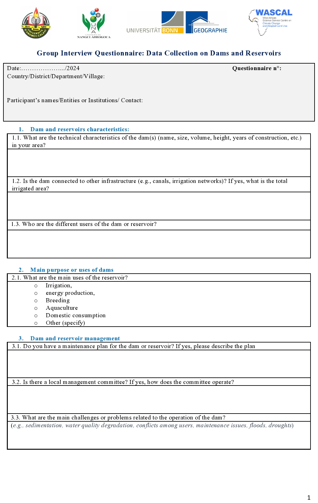
Figure A1Structured questionnaire used to collect data on dams and reservoirs during the field survey in the Upper Bandama Watershed (Sudanian savannah, Côte d'Ivoire).
Table B1Distribution of Group Interview Sizes Across Districts and Villages Surveyed in the Upper Bandama Watershed for the field campaign at watershed scale.
All authors contributed to the study's conception and design. Valery Bessely Stanislas Kouassi, Blé Anouma Fhorest Yao, and Gneneyougo Emile Soro were responsible for data collection and the execution of field surveys. Valery Bessely Stanislas Kouassi carried out the data analysis and drafted the initial version of the manuscript. Gneneyougo Emile Soro, Albert Bi Tié Goula, Nelly Carine Kelome-Ahouangnivo, and Julian Klaus provided critical feedback on earlier versions of the manuscript. All authors reviewed and approved the final version of the manuscript.
The contact author has declared that none of the authors has any competing interests.
Publisher's note: Copernicus Publications remains neutral with regard to jurisdictional claims made in the text, published maps, institutional affiliations, or any other geographical representation in this paper. The authors bear the ultimate responsibility for providing appropriate place names. Views expressed in the text are those of the authors and do not necessarily reflect the views of the publisher.
The authors gratefully acknowledge the support of the Graduate Research Program in Climate Change & Water Resources (GRP CC&WR) of the West African Science Service Centre on Climate Change and Adapted Land Use (WASCAL), funded by the German Federal Ministry of Education and Research (BMBF) (https://wascal.org/, last access: 22 January 2026). We also express our sincere appreciation to the University of Bonn for the Argelander Scholarships for doctoral candidates from universities in Africa, Latin America, and South/East Asia, which provided valuable financial support for this research.
Further acknowledgments go to Mr. Abdoulaye Diara, Head of Rural Planning at the Agriculture and Rural Development Department of the National Office of Technical Studies and Development (BNETD) of Côte d'Ivoire and the administrative and traditional authorities, local rural dam management organizations, cooperatives, and user associations in the Upper Bandama watershed for their collaboration and field support.
This research has been supported by the West African Science Service Centre on Climate Change and Adapted Land Use (cohort 2021–2025) and the Rheinische Friedrich-Wilhelms-Universität Bonn (Argelander Scholarships for doctoral candidates from universities in Africa, Latin America, and South/East Asia, cohort 2024–2025).
This paper was edited by James Thornton and reviewed by two anonymous referees.
Abobi, S. M. and Wolff, M.: West African reservoirs and their fisheries: An assessment of harvest potential, Ecohydrol. Hydrobiol., 20, 183–195, https://doi.org/10.1016/j.ecohyd.2019.11.004, 2020.
Anghileri, D., Pastori, M., Marcos-Garcia, P., Umlauf, G., Crestaz, E., Seliger, R., Iervolino, A., Cordano, E., Cattaneo, L., and Carmona-Moreno, C.: Global Water Challenges in Sub-Saharan Africa and how to strengthen science-policy dialogues on transboundary governance and cooperation, J. Environ. Manage., 365, 121417, https://doi.org/10.1016/j.jenvman.2024.121417, 2024.
Bai, B., Mu, L., and Tan, Y.: A Global Lakes/Reservoirs Surface Extent Dataset (GLRSED ): An Integration of Multi‐Source Data, Geosci. Data J., 12, https://doi.org/10.1002/gdj3.285, 2025.
Beck, H. E., McVicar, T. R., Vergopolan, N., Berg, A., Lutsko, N. J., Dufour, A., Zeng, Z., Jiang, X., van Dijk, A. I. J. M., and Miralles, D. G.: High-resolution (1 km) Köppen-Geiger maps for 1901–2099 based on constrained CMIP6 projections, Sci. Data, 10, 724, https://doi.org/10.1038/s41597-023-02549-6, 2023.
Bernacsek, G. M.: Dam design and operation to optimize fish production in impounded river basins, Food and Agriculture Organization of the United Nations, Rome, Italy, CIFAA Technical Paper (Committee of Inland Fisheries and Aquaculture for Africa), 0379-5616 – CIFA/T11, ISBN 92-5-101485-X, https://www.fao.org/4/ac675e/AC675E00.htm (last access: 7 September 2026), 1984.
Biswas, A. K. and Tortajada, C.: Development and Large Dams: A Global Perspective, Int. J. Water Resour. D., 17, 9–21, https://doi.org/10.1080/07900620120025024, 2001.
Boulange, J., Hanasaki, N., Yamazaki, D., and Pokhrel, Y.: Role of dams in reducing global flood exposure under climate change, Nat. Comm., 12, 417, https://doi.org/10.1038/s41467-020-20704-0, 2021.
Brewitt, P. K. and Colwyn, C. L. M.: Little dams, big problems: The legal and policy issues of nonjurisdictional dams, WIREs Water, 7, https://doi.org/10.1002/wat2.1393, 2020.
Cecchi, P., Forkuor, G., Cofie, O., Lalanne, F., Poussin, J.-C., and Jamin, J.-Y.: Small Reservoirs, Landscape Changes and Water Quality in Sub-Saharan West Africa, Water, 12, 1967, https://doi.org/10.3390/w12071967, 2020.
Cecchi, P., Gourdin, F., Koné, S., Corbin, D., Etienne, J., and Casenave, A.: Les petits barrages du nord de la Côte d'Ivoire inventaire et potentialités hydrologiques, Sécheresse, 20, 112–122, https://doi.org/10.1684/sec.2009.0164, 2009a.
Cecchi, P., Meunier-Nikiema, A., Moiroux, N., and Sanou, B.: Towards an atlas of lakes and reservoirs in Burkina Faso: Small Reservoirs Toolkit, HAL, https://hal.science/hal-02968297/document (last access: 15 January 2026), 2009b.
Chun, K. P., Dieppois, B., He, Q., Sidibe, M., Eden, J., Paturel, J.-E., Mahé, G., Rouché, N., Klaus, J., and Conway, D.: Identifying drivers of streamflow extremes in West Africa to inform a nonstationary prediction model, Weather. Clim. Extreme., 33, 100346, https://doi.org/10.1016/j.wace.2021.100346, 2021.
Cosgrove, W. J. and Loucks, D. P.: Water management: Current and future challenges and research directions, Water Resour. Res., 51, 4823–4839, https://doi.org/10.1002/2014WR016869, 2015.
Dang, T. D., Chowdhury, A. F. M. K., and Galelli, S.: On the representation of water reservoir storage and operations in large-scale hydrological models: implications on model parameterization and climate change impact assessments, Hydrol. Earth Syst. Sci., 24, 397–416, https://doi.org/10.5194/hess-24-397-2020, 2020.
Donchyts, G., Winsemius, H., Baart, F., Dahm, R., Schellekens, J., Gorelick, N., Iceland, C., and Schmeier, S.: High-resolution surface water dynamics in Earth's small and medium-sized reservoirs, Sci. Rep., 12, 13776, https://doi.org/10.1038/s41598-022-17074-6, 2022.
Du, T. L. T., Lee, H., Bui, D. D., Graham, L. P., Darby, S. D., Pechlivanidis, I. G., Leyland, J., Biswas, N. K., Choi, G., Batelaan, O., Bui, T. T. P., Do, S. K., Tran, T. V., Nguyen, H. T., and Hwang, E.: Streamflow Prediction in Highly Regulated, Transboundary Watersheds Using Multi-Basin Modeling and Remote Sensing Imagery, Water Resour. Res., 58, e2021WR031191, https://doi.org/10.1029/2021WR031191, 2022.
Ehsani, N., Vörösmarty, C. J., Fekete, B. M., and Stakhiv, E. Z.: Reservoir operations under climate change: Storage capacity options to mitigate risk, J. Hydrol., 555, 435–446, https://doi.org/10.1016/j.jhydrol.2017.09.008, 2017.
Ekka, A., Jiang, Y., Pande, S., and van der Zaag, P.: How economically and environmentally viable are multiple dams in the upper Cauvery Basin, India? A hydro-economic analysis using a landscape-based hydrological model, Hydrol. Earth Syst. Sci., 28, 3219–3241, https://doi.org/10.5194/hess-28-3219-2024, 2024.
Eslamian, S., Gohari, A. R., Ostad-Ali-Askari, K., and Sadeghi, N.: Reservoirs, in: Encyclopedia of Engineering Geology, edited by: Bobrowsky, P. T. and Marker, B., Springer International Publishing, Cham, 746–751, https://doi.org/10.1007/978-3-319-73568-9_236, 2018.
FAO: AQUASTAT – FAO's global information system on water and agriculture: geo-referenced database on dams, FAO, https://www.fao.org/aquastat/en/databases/dams (last access: 11 February 2025), 2021.
FAO: Geo-referenced database on dams in Africa: Notes and References, http://www.fao.org/nr/water/aquastat/dams/index.stm (last access: 11 February 2025), 2007.
Fink, A. H., Engel, T., Ermert, V., van der Linden, R., Schneidewind, M., Redl, R., Afiesimama, E., Thiaw, W. M., Yorke, C., Evans, M., and Janicot, S.: Mean Climate and Seasonal Cycle, in: Meteorology of Tropical West Africa, edited by: Parker, D. J. and Diop‐Kane, M., Wiley, 1–39, https://doi.org/10.1002/9781118391297.ch1, 2017.
Fluixá-Sanmartín, J., Escuder-Bueno, I., Morales-Torres, A., and Castillo-Rodríguez, J. T.: Accounting for Climate Change Uncertainty in Long-Term Dam Risk Management, J. Water Res. Plan. Man., 147, https://doi.org/10.1061/(ASCE)WR.1943-5452.0001355, 2021.
Fluixá-Sanmartín, J., Altarejos-García, L., Morales-Torres, A., and Escuder-Bueno, I.: Review article: Climate change impacts on dam safety, Nat. Hazards Earth Syst. Sci., 18, 2471–2488, https://doi.org/10.5194/nhess-18-2471-2018, 2018.
Fowé, T., Yonaba, R., Mounirou, L. A., Ouédraogo, E., Ibrahim, B., Niang, D., Karambiri, H., and Yacouba, H.: From meteorological to hydrological drought: a case study using standardized indices in the Nakanbe River Basin, Burkina Faso, Nat. Hazards, 119, 1941–1965, https://doi.org/10.1007/s11069-023-06194-5, 2023.
Ghimire, S. N. and Schulenberg, J. W.: Impacts of Climate Change on the Environment, Increase in Reservoir Levels, and Safety Threats to Earthen Dams: Post Failure Case Study of Two Cascading Dams in Michigan, Civ. Environ. Eng., 18, 551–564, https://doi.org/10.2478/cee-2022-0053, 2022.
Helfer, F., Lemckert, C., and Zhang, H.: Impacts of climate change on temperature and evaporation from a large reservoir in Australia, J. Hydrol., 475, 365–378, https://doi.org/10.1016/j.jhydrol.2012.10.008, 2012.
Hennig, T., Harlan, T., Tilt, B., and Magee, D.: Hydropower development in South Asia: Data challenges, new approaches, and implications for decision‐making, WIREs Water, 10, https://doi.org/10.1002/wat2.1654, 2023.
Hou, J., van Dijk, A. I. J. M., Beck, H. E., Renzullo, L. J., and Wada, Y.: Remotely sensed reservoir water storage dynamics (1984–2015) and the influence of climate variability and management at a global scale, Hydrol. Earth Syst. Sci., 26, 3785–3803, https://doi.org/10.5194/hess-26-3785-2022, 2022.
ICOLD: World Register of Dams (WRD): general synthesis, International Commission On Large Dams, https://www.icold-cigb.org/article/GB/worldregistergeneralsynthesis/general-synthesis (last access: 10 February 2025), 2024.
Jeppe Kolding: Fisheries in the Drylands of Sub-Saharan Africa – “Fish come with the rains”: Building resilience for fisheries-dependent livelihoods to enhance food security and nutrition in the Drylands, FAO Fisheries and Aquaculture Circular No. 1118, Food and Agriculture Organization of the United Nations (FAO), Rome, Italy, ISBN 978-92-5-109219-4, 2016.
Jing, M., Cheng, L., Ji, C., Mao, J., Li, N., Duan, Z., Li, Z., and Li, M.: Detecting unknown dams from high-resolution remote sensing images: A deep learning and spatial analysis approach, Int. J. Appl. Earth Obs., 104, 102576, https://doi.org/10.1016/j.jag.2021.102576, 2021.
Joseph, J., Ghosh, S., Pathak, A., and Sahai, A. K.: Hydrologic impacts of climate change: Comparisons between hydrological parameter uncertainty and climate model uncertainty, J. Hydrol., 566, 1–22, https://doi.org/10.1016/j.jhydrol.2018.08.080, 2018.
Kachoue, M. H., Goli, M., Bakhtiari, A., Sedghi, M., Hosseinipoor, M., and Khorashadi Zadeh, F.: Water Balance Analysis for Reservoirs through Remote Sensing: A Case Study of the Karun (IV) Reservoir in Iran., EGU General Assembly 2024, Vienna, Austria, 14–19 Apr 2024, EGU24-4660, https://doi.org/10.5194/egusphere-egu24-4660, 2024.
Kaup, F.: The Sugarcane Complex in Brazil: The Role of Innovation in a Dynamic Sector on Its Path Towards Sustainability, Contributions to Economics, Springer Cham, Cham, https://doi.org/10.1007/978-3-319-16583-7, 2015.
Khandelwal, A., Karpatne, A., Ravirathinam, P., Ghosh, R., Wei, Z., Dugan, H. A., Hanson, P. C., and Kumar, V.: ReaLSAT, a global dataset of reservoir and lake surface area variations, Sci. Data, 9, https://doi.org/10.1038/s41597-022-01449-5, 2022.
Khazaei, B., Read, L. K., Casali, M., Sampson, K. M., and Yates, D. N.: GLOBathy, the global lakes bathymetry dataset, Sci. Data, 9, 36, https://doi.org/10.1038/s41597-022-01132-9, 2022.
Klein, B. and Kenney, D. S.: The Land Use Planning, Water Resources and Climate Change Adaptation Connection: Challenges and Opportunities, A review, Natural Res. Law Ctr., Univ. of Colo. Law Sch., https://scholar.law.colorado.edu/cgi/viewcontent.cgi?article=1130&context=books_reports_studies (last access: 7 September 2026), 2009.
Kopperud, B. T., Lidgard, S., and Liow, L. H.: Text-mined fossil biodiversity dynamics using machine learning, Proc. Biol. Sci., 286, 20190022, https://doi.org/10.1098/rspb.2019.0022, 2019.
Kouassi, V. B. S., Yao, B. A. F., Soro, G. E., Goula, B. T. A., Kelome, N. C., and Klaus, J.: West Africa Dams and Reservoirs Dataset, bonndata [data set], https://doi.org/10.60507/FK2/YLDK1Y, 2026.
Latrubesse, E. M., Arima, E. Y., Dunne, T., Park, E., Baker, V. R., d'Horta, F. M., Wight, C., Wittmann, F., Zuanon, J., Baker, P. A., Ribas, C. C., Norgaard, R. B., Filizola, N., Ansar, A., Flyvbjerg, B., and Stevaux, J. C.: Damming the rivers of the Amazon basin, Nature, 546, 363–369, https://doi.org/10.1038/nature22333, 2017.
Lehner, B. and Grill, G.: Global river hydrography and network routing: baseline data and new approaches to study the world's large river systems, Hydrol. Process., 27, 2171–2186, https://doi.org/10.1002/hyp.9740, 2013.
Lehner, B. and Döll, P.: Development and validation of a global database of lakes, reservoirs and wetlands, J. Hydrol., 296, 1–22, https://doi.org/10.1016/j.jhydrol.2004.03.028, 2004.
Lehner, B., Beames, P., Mulligan, M., Zarfl, C., Felice, L. de, van Soesbergen, A., Thieme, M., Garcia de Leaniz, C., Anand, M., Belletti, B., Brauman, K. A., Januchowski-Hartley, S. R., Lyon, K., Mandle, L., Mazany-Wright, N., Messager, M. L., Pavelsky, T., Pekel, J.-F., Wang, J., Wen, Q., Wishart, M., Xing, T., Yang, X., and Higgins, J.: The Global Dam Watch database of river barrier and reservoir information for large-scale applications, Sci. Data, 11, 1069, https://doi.org/10.1038/s41597-024-03752-9, 2024.
Lehner, B., Liermann, C. R., Revenga, C., Vörösmarty, C., Fekete, B., Crouzet, P., Döll, P., Endejan, M., Frenken, K., Magome, J., Nilsson, C., Robertson, J. C., Rödel, R., Sindorf, N., and Wisser, D.: High‐resolution mapping of the world's reservoirs and dams for sustainable river‐flow management, Front. Ecol. Environ., 9, 494–502, https://doi.org/10.1890/100125, 2011.
Lèye, B., Zouré, C. O., Yonaba, R., and Karambiri, H.: Water Resources in the Sahel and Adaptation of Agriculture to Climate Change: Burkina Faso, in: Climate Change and Water Resources in Africa, edited by: Diop, S., Scheren, P., and Niang, A., Springer International Publishing, Cham, 309–331, https://doi.org/10.1007/978-3-030-61225-2_14, 2021.
Li, J., Zhang, S., Obulkasim, O., Lu, X., Wei, Z., Yuan, H., Li, L., Zeng, J., Yang, D., and Dai, Y.: Impact of Reservoirs on Local Precipitation‐Temperature Coupling Relationships, Geophys. Res. Lett., 50, https://doi.org/10.1029/2023GL103453, 2023.
Mady, B., Lehmann, P., Gorelick, S. M., and Or, D.: Distribution of small seasonal reservoirs in semi-arid regions and associated evaporative losses, Environ. Res. Commun., 2, 61002, https://doi.org/10.1088/2515-7620/ab92af, 2020.
Magilligan, F. J. and Nislow, K. H.: Long‐term changes in regional hydrologic regime following impoundment in a humid‐climate watershed1, J. Am. Water Resour. As., 37, 1551–1569, https://doi.org/10.1111/j.1752-1688.2001.tb03659.x, 2001.
Makarigakis, A. K. and Jimenez-Cisneros, B. E.: UNESCO's Contribution to Face Global Water Challenges, Water, 11, 388, https://doi.org/10.3390/w11020388, 2019.
McManamay, R. A.: Quantifying and generalizing hydrologic responses to dam regulation using a statistical modeling approach, J. Hydrol., 519, 1278–1296, https://doi.org/10.1016/j.jhydrol.2014.08.053, 2014.
Messager, M. L., Lehner, B., Grill, G., Nedeva, I., and Schmitt, O.: Estimating the volume and age of water stored in global lakes using a geo-statistical approach, Nat. Comm., 7, 13603, https://doi.org/10.1038/ncomms13603, 2016.
Minocha, S. and Hossain, F.: GRILSS: opening the gateway to global reservoir sedimentation data curation, Earth Syst. Sci. Data, 17, 1743–1759, https://doi.org/10.5194/essd-17-1743-2025, 2025.
Mirus, B. B., Loague, K., Cristea, N. C., Burges, S. J., and Kampf, S. K.: A synthetic hydrologic‐response dataset, Hydrol. Process., 25, 3688–3692, https://doi.org/10.1002/hyp.8185, 2011.
Moussa Ouedraogo: Caractérisation des aquifères de socle pour l'amélioration de la productivité des forages d'hydraulique villageoise dans le bassin versant du Bandama blanc amont (Nord de la Côte d'Ivoire), Doctoral dissertation, Géophysique [physics.geo-ph], Université Paris Saclay, France, https://doi.org/10.70675/b2bccffaz649dz4f69z8c88zdb684f727aa0, 2016.
Moyroud, N. and Portet, F.: Introduction to QGIS, in: QGIS and Generic Tools, edited by: Baghdadi, N., Mallet, C., and Zribi, M., Wiley, 1–17, https://doi.org/10.1002/9781119457091.ch1, 2018.
Mu, M., Tang, Q., Han, S., Liu, X., and Cui, H.: Using GRanD Database and Surface Water Data to Constrain Area–Storage Curve of Reservoirs, Water, 12, 1242, https://doi.org/10.3390/w12051242, 2020.
Mulligan, M., Lehner, B., Zarfl, C., Thieme, M., Beames, P., van Soesbergen, A., Higgins, J., Januchowski-Hartley, S. R., Brauman, K. A., Felice, L. de, Wen, Q., Garcia de Leaniz, C., Belletti, B., Mandle, L., Yang, X., Wang, J., and Mazany-Wright, N.: Global Dam Watch: curated data and tools for management and decision making, Environ. Res.: Infrastruct. Sustain., 1, 33003, https://doi.org/10.1088/2634-4505/ac333a, 2021.
Mulligan, M., van Soesbergen, A., and Sáenz, L.: GOODD, a global dataset of more than 38,000 georeferenced dams, Sci. Data, 7, 31, https://doi.org/10.1038/s41597-020-0362-5, 2020.
Ndao, S., Lenouo, A., Badiane, D., Penka, M., Tchawoua, C., Sall, S. M., and Gaye, A. T.: Climatology of West Africa boundary layer, Terr. Atmos. Ocean. Sci., 31, 619–632, https://doi.org/10.3319/TAO.2020.04.21.01, 2020.
Ndehedehe, C. E.: The water resources of tropical West Africa: problems, progress, and prospects, Acta Geophys., 67, 621–649, https://doi.org/10.1007/s11600-019-00260-y, 2019.
O'Brien, T. A., Kashinath, K., Cavanaugh, N. R., Collins, W. D., and O'Brien, J. P.: A fast and objective multidimensional kernel density estimation method: fastKDE, Comput. Stat. Data An., 101, 148–160, https://doi.org/10.1016/j.csda.2016.02.014, 2016.
Owusu, S., Cofie, O., Mul, M., and Barron, J.: The Significance of Small Reservoirs in Sustaining Agricultural Landscapes in Dry Areas of West Africa: A Review, Water, 14, 1440, https://doi.org/10.3390/w14091440, 2022.
Oyerinde, G., Wisser, D., Hountondji, F., Odofin, A., Lawin, A., Afouda, A., and Diekkrüger, B.: Quantifying Uncertainties in Modeling Climate Change Impacts on Hydropower Production, Climate, 4, 34, https://doi.org/10.3390/cli4030034, 2016.
Paredes-Beltran, B., Sordo-Ward, A., and Garrote, L.: Dataset of Georeferenced Dams in South America (DDSA), Earth Syst. Sci. Data, 13, 213–229, https://doi.org/10.5194/essd-13-213-2021, 2021.
Pekel, J.-F., Cottam, A., Gorelick, N., and Belward, A. S.: High-resolution mapping of global surface water and its long-term changes, Nature, 540, 418–422, https://doi.org/10.1038/nature20584, 2016.
Peña-Angulo, D., Tramblay, Y., Vicente-Serrano, S. M., Ekolu, J., Dieppois, B., and El Kenawy, A.: Multidecadal changes in hydrological droughts across Sub-Saharan Africa, J. Hydrol.: Reg. Stud., 60, 102595, https://doi.org/10.1016/j.ejrh.2025.102595, 2025.
Quenum, G. M. L. D., Klutse, N. A. B., Dieng, D., Laux, P., Arnault, J., Kodja, J. D., and Oguntunde, P. G.: Identification of Potential Drought Areas in West Africa Under Climate Change and Variability, Earth Syst. Environ., 3, 429–444, https://doi.org/10.1007/s41748-019-00133-w, 2019.
Quimby, B. and Beresford, M.: Participatory Modeling: A Methodology for Engaging Stakeholder Knowledge and Participation in Social Science Research, Field Method., 35, 73–82, https://doi.org/10.1177/1525822X221076986, 2023.
Rahman, S. U., Chen, Y., Su, Y., Zhang, H., Yousaf, S., Riaz, M., Ayub, G., and Zahir, M.: PGIS as a Tool for Reservoir Health Assessment: Community Insights Validated by Laboratory Analysis and Remote Sensing, Ecohydrology, 18, https://doi.org/10.1002/eco.70005, 2025.
Schulz, C. and Adams, W. M.: Debating dams: The World Commission on Dams 20 years on, WIREs Water, 6, https://doi.org/10.1002/wat2.1369, 2019.
Song, C., Fan, C., Zhu, J., Wang, J., Sheng, Y., Liu, K., Chen, T., Zhan, P., Luo, S., Yuan, C., and Ke, L.: A comprehensive geospatial database of nearly 100 000 reservoirs in China, Earth Syst. Sci. Data, 14, 4017–4034, https://doi.org/10.5194/essd-14-4017-2022, 2022.
The United Nations – Department of Economic and Social Affairs: UN Revision of World Population Prospects 2024, United Nations (UN), ISBN 9789210031691, 2024.
Umukiza, E., Abagale, K. F., and Adongo, T. A.: A Review on Significance and Failure Causes of Small-Scale Irrigation Dams in Arid and Semi-arid Lands (ASAL), J. Infrastruct. Plan. Eng., 2, 1–9, https://doi.org/10.22225/jipe.2.2.2023.1-9, 2023.
Utama, I. P. W., Arthana, I. W., and Nuarsa, I. W.: Assessing lake shoreline change and prediction for 2030 by physical drivers: A Case Study from Lake Batur, Batur UNESCO Global Geopark, Bali, Int. J. Geosci. Environ., 5, 14, https://doi.org/10.24843/ijeg.2024.v05.i01.p02, 2024.
Wang, J., Walter, B. A., Yao, F., Song, C., Ding, M., Maroof, A. S., Zhu, J., Fan, C., McAlister, J. M., Sikder, S., Sheng, Y., Allen, G. H., Crétaux, J.-F., and Wada, Y.: GeoDAR: georeferenced global dams and reservoirs dataset for bridging attributes and geolocations, Earth Syst. Sci. Data, 14, 1869–1899, https://doi.org/10.5194/essd-14-1869-2022, 2022.
Wang, Y., Yan, N., Zhu, W., Ma, Z., and Wu, B.: A method to estimate the water storage of on-farm reservoirs by detecting slope gradients based on multi-spectral drone data, Agr. Water Manage., 307, 109241, https://doi.org/10.1016/j.agwat.2024.109241, 2025.
Watts, R. J., Richter, B. D., Opperman, J. J., and Bowmer, K. H.: Dam reoperation in an era of climate change, Mar. Freshwater Res., 62, 321, https://doi.org/10.1071/MF10047, 2011.
Wheater, H. S. and Gober, P.: Water security and the science agenda, Water Resour. Res., 51, 5406–5424, https://doi.org/10.1002/2015WR016892, 2015.
Yang, X., Pavelsky, T. M., Ross, M. R. V., Januchowski‐Hartley, S. R., Dolan, W., Altenau, E. H., Belanger, M., Byron, D., Durand, M., van Dusen, I., Galit, H., Jorissen, M., Langhorst, T., Lawton, E., Lynch, R., Mcquillan, K. A., Pawar, S., and Whittemore, A.: Mapping Flow‐Obstructing Structures on Global Rivers, Water Resour. Res., 58, https://doi.org/10.1029/2021WR030386, 2022.
Yassin, F., Razavi, S., Elshamy, M., Davison, B., Sapriza-Azuri, G., and Wheater, H.: Representation and improved parameterization of reservoir operation in hydrological and land-surface models, Hydrol. Earth Syst. Sci., 23, 3735–3764, https://doi.org/10.5194/hess-23-3735-2019, 2019.
Yazdandoost, F.: Dams, Drought and Water Shortage in Today's Iran, in: Iranian Studies, Cambridge University Press, 49, 1017–1028, https://doi.org/10.1080/00210862.2016.1241626, 2016.
Ye, C., Duan, H., Zhang, H., Zhang, H., Wang, H., and Dai, G.: Multi-Source Data Repairing: A Comprehensive Survey, Mathematics, 11, 2314, https://doi.org/10.3390/math11102314, 2023.
Youkhana, E. and Laube, W.: Virtual water trade: a realistic policy option for the countries of the Volta Basin in West Africa?, Water Policy, 11, 569–581, https://doi.org/10.2166/wp.2009.087, 2009.
Zarfl, C., Lumsdon, A. E., Berlekamp, J., Tydecks, L., and Tockner, K.: A global boom in hydropower dam construction, Aquat. Sci., 77, 161–170, https://doi.org/10.1007/s00027-014-0377-0, 2015.
Zhang, A. T. and Gu, V. X.: Global Dam Tracker: A database of more than 35,000 dams with location, catchment, and attribute information, Sci. Data, 10, 111, https://doi.org/10.1038/s41597-023-02008-2, 2023.
Ziv, G., Baran, E., Nam, S., Rodríguez-Iturbe, I., and Levin, S. A.: Trading-off fish biodiversity, food security, and hydropower in the Mekong River Basin, P. Natl. Acad. Sci. USA, 109, 5609–5614, https://doi.org/10.1073/pnas.1201423109, 2012.
Zogheib, C., Ochoa-Tocachi, B. F., Paul, J. D., Hannah, D. M., Clark, J., and Buytaert, W.: Exploring a water data, evidence, and governance theory, Water Secur., 4-5, 19–25, https://doi.org/10.1016/j.wasec.2018.11.004, 2018.