the Creative Commons Attribution 4.0 License.
the Creative Commons Attribution 4.0 License.
 | 19 Jan 2026
Mapping and spatial distribution of relict charcoal hearths across Poland
Michał Słowiński
Agnieszka Halaś
Michał A. Niedzielski
Krzysztof Szewczyk
Jerzy Jonczak
Dominika Łuców
Sebastian Tyszkowski
Sandra Słowińska
Agnieszka Gruszczyńska
Bogusława Kruczkowska
Aleksandra Chojnacka
Tomasz Polkowski
Krzysztof Sztabkowski
Dariusz Brykała
Jacek Wolski
Tomasz Samojlik
Adrian Kaszkiel
Barbara Gmińska-Nowak
Mateusz Kramkowski
Tomasz Związek
This study presents the first national-scale spatial inventory of relict charcoal hearths (RCHs) in Poland, based on high-resolution LiDAR data and digital terrain analysis. Using a combination of manual interpretation, GIS-based feature extraction, and K-prototypes clustering, we identified and classified 634 815 RCHs across forested regions of the country. Each feature was georeferenced and categorized by size, morphological characteristics, slope position, and environmental context, including current and potential vegetation and soil types. Spatial analyses revealed significant regional differences in hearth density, with the highest concentrations found in western and south-central Poland, particularly in the Lower Silesian, Stobrawa, and Świętokrzyskie forests. Cluster analysis distinguished three major types of RCHs, differing in their environmental settings and spatial organization: (1) lowland pine-dominated clusters on gentle terrain, (2) isolated features on steep slopes in mixed forests, and (3) high-density hearth groups in elevated areas. Although large portions of the country appear devoid of RCHs, we argue that this reflects limitations in preservation and detection – due to long-term agricultural activity in lowlands and erosion in mountainous areas – rather than an actual absence of charcoal production. The resulting ReCHAR database offers a unique, open-access tool for interdisciplinary research on forest history, human–environment interactions, and early industrial landscapes. Its modular design supports further expansion, including links to historical settlements and industries reliant on charcoal, such as metallurgy, glassmaking, and tar or potash production. The data set is available at https://doi.org/10.5281/zenodo.15630690 (Słowiński et al., 2025).
- Article
(7014 KB) - Full-text XML
-
Supplement
(13748 KB) - BibTeX
- EndNote


In the preindustrial era, forests and their resources were crucial to the economic development of European countries (Słowiński et al., 2024; Przybylski et al., 2025; Ellis, 2021). Initially, the primary demand was for wood as a construction material; however, over time, the focus shifted to other forest products such as potash, tar, pitch, and especially charcoal. These pyrolysis products found wide-ranging applications in daily life and various industries. Charcoal, due to its high energy value, served as a primary source in metal smelting and glass production. Potash was essential for fabric bleaching, producing glass and gunpowder; moreover, it served as a cleaning agent or even medicine (Ciceri et al., 2015; White, 1859). Wood tar was used as a wood preservative, adhesive, grease and medicine (birch tar) (Ebert, 2024). The techniques for producing these pyrolysis products evolved significantly over time. Early charcoal production methods were relatively inefficient, carried out in small pits measuring from one to five meters in diameter and from 1–2 m in depth. These pits were primarily filled with branches and roots before being covered with earth and mulch (Groenewoudt, 2005; Klein and Bauch, 1983). This method represents one of the earliest known forms of charcoal extraction worldwide. Such features can be traced back to Roman times in Europe. For example, in modern-day Germany, remains dating to the third century AD have been discovered (Codreanu-Windauer, 2019). In Western Europe, from the late 10th to the early 11th centuries, these pits were increasingly replaced by elevated constructions known as charcoal hearths. Charcoal hearths varied significantly in size and construction (Raab et al., 2015b; Oliveira et al., 2021; Witharana et al., 2018). They were essentially stacked piles of wood, ranging in diameter from a few meters to over 20 m (Raab et al., 2015a; Groenewoudt and Spek, 2016), covered with topsoil, turf, and forest litter from the surrounding area (Paschalis, 1973; Samojlik et al., 2013b; Rutkiewicz et al., 2019; Bielenin, 1959). These hearths were often encircled by a ditch or embankment approximately 40 cm in height or depth (Hirsch et al., 2020). The morphological characteristics of charcoal hearths – such as their size, shape, and function – often depended on the region, terrain, and period in which they were built (Hirsch et al., 2020). For example, hearths used for tar production were typically found in forests dominated by pine and included small peripheral depressions for collecting tar in special bowls (Cembrzyński, 2014). Hearths constructed on slopes were generally smaller, averaging from eight to ten meters in diameter, and were built on artificial mounds often reused in subsequent burning cycles (Hirsch et al., 2018). The main advantage of charcoal is its ability to reach high combustion temperatures – from 900 to as much as 2000 °C (Smil, 2017). Additionally, it burns almost smoke free and has an energy value 50 % higher than that of air-dried wood. It contains minimal moisture and is practically free of sulfur and phosphorus (Smil, 2017). Until the mid-19th century, charcoal remained the only widely available fuel in Europe capable of reaching the temperatures required to melt iron ore (Cleere et al., 1985). In the latter half of the 19th century, it was gradually replaced by more energy efficient fuels such as coal coke, hard coal, oil, and natural gas (Cembrzyński, 2014).
A single charcoal hearth could consume 48–100 m3 wood (Marszałek and Kusiak, 2013). This resource hungry way of manufacturing charcoal and other pyrolysis products have had a direct impact on the environment (Hensel et al., 1978). The most immediate effect was deforestation. Increasing demand for products like potash, steel, and glass led to large scale forest depletion (Hensel et al., 1978). Massive deforestation occurred at the turn of the 18th and 19th centuries, in what is now Poland, transformed the landscape dramatically (Hensel et al., 1978). Forest cover in the Kingdom of Poland was around 30 % at the beginning of the 19th century, but by 1909, it had decreased to 18.7 %. Afterwards, deforested areas fell under the modern forestry management, with large areas reforested with pine or spruce monocultures, shifting the forest composition from deciduous to coniferous (Słowiński et al., 2019, 2024; Przybylski et al., 2025; Związek et al., 2023). At the same time, wetlands were drained, and former wastelands and forests were converted to farmland (Blackbourn, 2006; Surowiecki, 1811).
Charcoal production in hearths influenced soils both directly and indirectly. The direct impact involved thermal alteration (300–600 °C) of soil beneath hearths during pyrolysis, leading to changes in mineral composition and loss of organic matter (Hirsch et al., 2018). These soils are rich in charcoal and often facilitate the reduction of iron oxides to metallic iron. Typically classified as Technosols (IUSS Working Group WRB, 2022), they exhibit distinct physical and chemical properties resulting from pyrolysis byproducts (Hirsch et al., 2018; Schneider et al., 2019, 2022; Jonczak et al., 2024). Indirect effects stemmed from deforestation in charcoal production areas, which enhanced surface runoff, erosion, and reduced soil moisture retention. This increased vulnerability to degradation and desertification (Pierik et al., 2018; Groenewoudt and Spek, 2016; Jonczak et al., 2024). On slopes, deforestation accelerated denudation and aeolian activity, hindering forest regeneration and plant growth (Groenewoudt and Spek, 2016). A further indirect and potentially long-lasting effect is visible in vegetation patterns. Elevated nitrogen levels under hearths, likely due to charcoal uptake, can influence plant community composition (Hirsch et al., 2017; Hardy et al., 2017). Additionally, trees growing in such soils often exhibit reduced vigour and lower timber quality (Buras et al., 2015, 2020; Hirsch et al., 2018).
Until recently, charcoal hearth remnants were usually encountered by chance during forestry or soil science work (Ludemann, 2012), or, in the best case, during field surveys (Samojlik et al., 2013a, b). These structures appear as circular mounds or groups of mounds, often several meters in diameter across, consisting of soil mixed with charcoal particles or charcoal dust, covered with organic debris and recent sediments. Their detection has been greatly facilitated by Airborne Laser Scanning (ALS) and Light Detection and Ranging (LiDAR) technology and GIS based analysis (Suh et al., 2021, 2023). Such studies have been conducted in Germany (Raab et al., 2015a; Hirsch et al., 2017), USA (Suh et al., 2023; der Vaart et al., 2022; Bonhage et al., 2023), Sweden (Davis and Lundin, 2021), France (Dupin et al., 2017), Italy (Garbarino et al., 2022), and Poland (Samojlik et al., 2013b; Rutkiewicz et al., 2019; Jonczak et al., 2024; Słowiński et al., 2022). Importantly, LiDAR allowed researchers to identify features beneath forest canopies and in areas previously inaccessible for field surveys. Previous studies have shown that hearths were rather preserved in less fertile soils, unsuitable for agriculture (Mikulski, 1994), than in areas with active cultivation. Importantly, this pattern reflects not only differential preservation under modern land use, but also the original placement of many RCHs in marginal landscapes with less productive soils, where forest use was favored over crop production. Due to that, many hearths were most likely destroyed by continuous farming practices like deep ploughing. Evidence for hearths in agricultural lands exists mainly in specific areas, such as in the Netherlands (Hardy et al., 2017).
Turning point in the research
Up to this point, research on charcoal hearths in Poland has primarily focused on individual sites or small groups of sites (Waga et al., 2022; Kałagate et al., 2012; Lasota et al., 2021; Samojlik et al., 2013b; Rutkiewicz et al., 2021). As a result, relatively little is known about their total number and spatial distribution on a much larger scale (e.g. the whole country), or the environmental conditions in which they occur. Given that the number and density of such features can have important environmental implications, it is essential to maintain an open-access database containing their locations and basic attributes. The main objective of this study is therefore to develop a comprehensive database detailing the location, size, density, and environmental context of relict charcoal hearths (RCHs) in Poland (Słowiński et al., 2025). In addition, the research aims to identify regional differences in charcoal production practices, with a focus on morphological characteristics, site location, and key environmental variables such as slope and proximity to water. Although the number of identified charcoal hearths offers great scientific potential, meaningful analysis would not be possible without first constructing a basic database. Such a database serves as a fundamental resource for broader regional considerations such as the historical functioning of forest ecosystems as well as more local topics, such as site specific degradation and disturbance processes. To achieve this, we analyzed a region in Poland covering 186 905.7 km2, which includes 60 107.9 km2 of forested land. This effort let to the creation of the first nationwide database documenting RCHs in Poland. The mapped sites were subsequently analyzed using geostatistical methods, linking the density and spatial distribution of RCHs to environmental conditions and potential vegetation. This newly developed database facilitates the investigation of regional variability in charcoal production techniques. Until now, it remained unclear whether distinct types of charcoal hearths existed, and to what extent production methods varied either regionally or as a function of hearth morphology. To address this knowledge gap, we applied clustering techniques to classify charcoal hearths based on both morphological and environmental parameters.
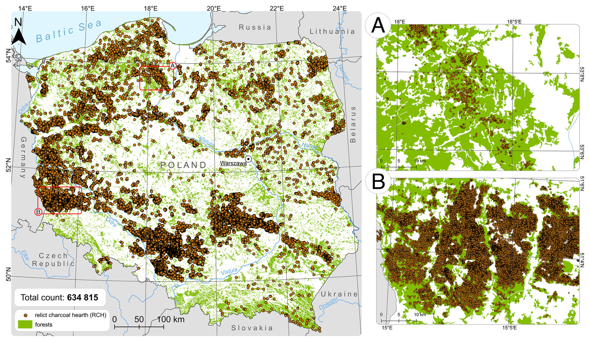
Figure 1Location of the study area within Poland with all identified Relict Charcoal Hearths (RCHs). The figure includes forest cover based on CORINE Land Cover 2018 (European Environmental Agency). Panels (a) and (b) present contrasting densities of RCH distribution across forested regions of Poland.
2.1 Study site
This study covers forested areas across the entire territory of Poland (Fig. 1). Outside forests particularly in farmland and other intensively transformed landscapes the detectability of charcoal hearth microrelief in ALS-derived Digital Terrain Model (DTMs) is very low and in many cases not feasible. Agricultural operations (ploughing, levelling, drainage, earthworks) and subsequent construction repeatedly disturb or obliterate these small relief features; therefore, our mapping was restricted to contemporary forests where such features are most likely to be preserved. As of 2023, forests in Poland covered approximately 9.3 million ha, which corresponds to 29.6 % of the country's land area (Forest Data Bank: https://www.bdl.lasy.gov.pl/portal/, last access: December 2025). Forest cover has increased significantly over the past century, rising from 21 % in 1945 to nearly 30 % today (Broda, 2000). This expansion has been largely driven by afforestation initiatives on former agricultural lands, particularly in lowland and central regions. The vast majority of forests in Poland are publicly owned. In 2021, public forests accounted for 80.7 % of all forested land, with 76.9 % managed by the State Forests National “Forest Holding” (Pol. Państwowe Gospodarstwo Leśne “Lasy Państwowe”). Forest composition is dominated by Scots pine (Pinus sylvestris), which represents approximately 58.5 % of all stands. These pine dominated monocultures, often established on poor sandy soils or reclaimed farmland, define much of the lowland forest landscape. Other tree species include birch (Betula spp.), oak (Quercus spp.), and beech (Fagus sylvatica), with spruce (Picea abies) and fir (Abies alba) commonly found in the mountainous regions (Matuszkiewicz, 1999).
Poland's geomorphology is the result of a complex history of glacial and tectonic processes. The northern and central lowlands were formed through a succession of Pleistocene glaciations particularly the Vistulian (Weichselian), Wartan, and older Odra and Sanian phases (Marks, 2002, 2005). These events left behind a wide range of glacial landforms including moraines, eskers, sandurs (outwash plains), and kettle lakes. In contrast, the southern part of the country is defined by tectonic uplift and erosion processes associated with the Sudetes and Carpathian Mountain ranges, leading to a more rugged and elevated landscape (Solon et al., 2018). The diversity of soils across Poland reflects this geomorphological variability. In the lowlands, particularly in the north and center, sandy and acidic soils are predominant. These include Arenosols (mainly Brunic Arenosols) and Podzols – soils typical for coniferous stands on fluvioglacial, glacial and aeolian sandy substrates (e.g. Jankowski et al., 2011; Kabała et al., 2021). In upland and mountainous regions, Cambisols (brown earths) are widespread, developed from loess, weathered rocks, or glacial tills, often supporting mixed or deciduous forests (Gałka et al., 2013; Kacprzak and Derkowski, 2007). Rendzinas, shallow calcareous soils developed from limestone and marl, are found in smaller patches, particularly in southern uplands, and support unique plant communities (Lasota et al., 2018; Miechówka and Drewnik, 2018). Climatically, Poland lies within the humid continental zone (Dfb according to the Köppen classification), characterized by cold winters and warm summers. The average annual temperature ranges from 7 to 9 °C (Kottek et al., 2006). Annual precipitation is regionally differentiated, ranging from about 500 mm in the central lowlands to over 1200 mm in mountainous regions (Institute of Meteorology and Water Management – National Research Institute). This combination of historical land use, ownership structure, glacial and tectonic legacy, and environmental heterogeneity provides a complex yet coherent context for analyzing the distribution of relict charcoal hearths (RCHs) across Polish forest landscapes.
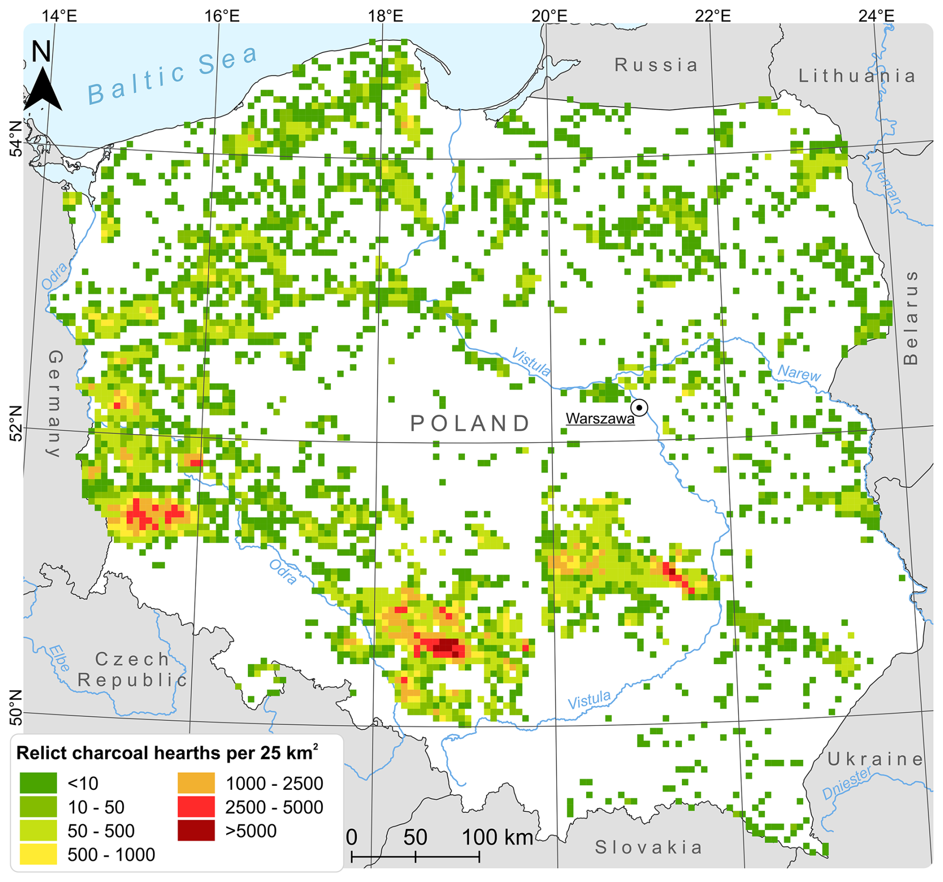
Figure 2Map of the spatial density of Relict Charcoal Hearths (RCHs) across forested areas of Poland.
2.2 Data collection
To identify and map all relict charcoal hearths (RCHs), we processed a DTM derived from Light Detection and Ranging (LiDAR) data in QGIS 3.18. The DTM was inspected using relief-shaded visualizations (single- and multi-azimuth hillshade and slope shading) generated directly in QGIS. For a consistent and reproducible cartographic backdrop, we also consumed a public web map tile service (WMTS) provided by the national geoportal (https://www.geoportal.gov.pl, last access: December 2025) under its full name “The viewing of shaded relief for a digital terrain model” (Geopartal, 2025).
A transparent grid with a resolution of 500×500 m was superimposed across the entire forested area (Fig. 2). This ensured comprehensive spatial coverage and minimized the risk of omissions during the manual interpretation of features. Charcoal hearths were visually recognized by their circular morphology and often occurred in dense clusters sometimes comprising several hundred objects within a single grid square.
Two primary morphological types were identified. The first type, commonly located on flat terrain, typically exceeded 15 m in diameter and was often surrounded by a visible ditch. The second type was constructed on specially prepared platforms on slopes; these hearths were generally smaller (under 10 m in diameter), lacked surrounding ditches, and appeared less prominently on LiDAR-derived surfaces. For analytical purposes, charcoal hearths were classified according to: (1) size – small (<10 m), medium (10–15 m), and large (>15 m); (2) surface context and function – based on both topography and evidence of extracted material. Three categories were distinguished: (A) hearths located on flat terrain; (B) hearths on flat terrain associated with tar extraction, often identifiable by peripheral ditches several centimeters wide and deep; (C) hearths located on slopes (Fig. 3). Charcoal hearths were exclusively identified within forested areas (Słowiński et al., 2025). In agricultural landscapes, these features have likely been destroyed due to soil disturbance caused by deep ploughing and other farming practices (Hardy et al., 2017). To verify the reliability of the identification process, a random sample of 50 grid squares was reviewed manually.
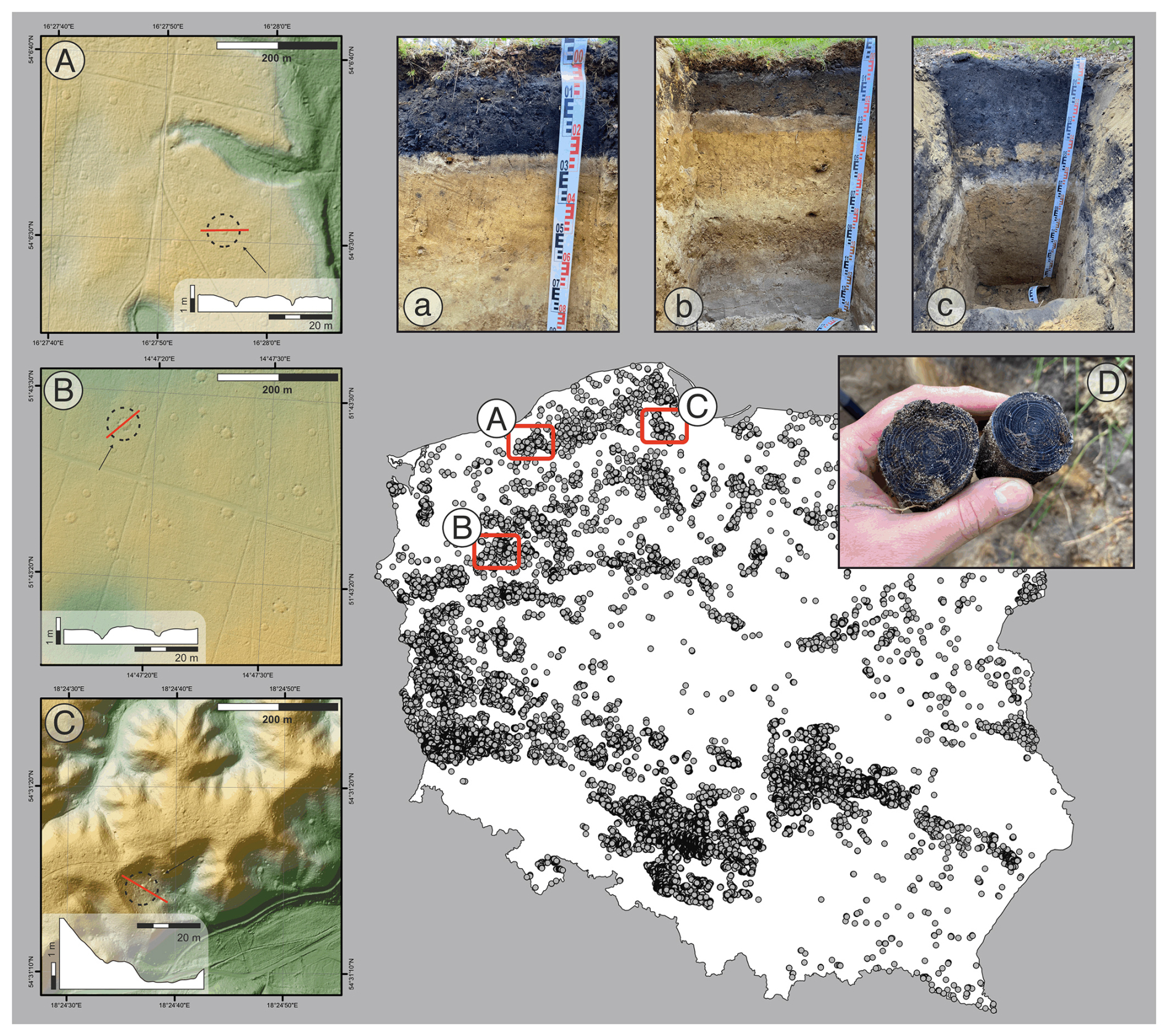
Figure 3Map of Poland with all identified Relict Charcoal Hearths (RCHs) with a schematic cross-section of three typical hearth configurations: (A) hearth located on flat terrain with visible hollows used for tar collection, (B) hearth built on a gentle slope without tar-extraction features, and (C) hearth situated on a steep incline, reflecting adaptation to challenging topographic conditions. Soil profiles (a–c) correspond to field-recorded sections for each hearth type. Picture (D) shows macroscopic charcoal fragments preserved in the soil profile.
Each relict charcoal hearth (RCH) was assigned a set of attributes to support further analysis. These included, in addition to the previously mentioned size, current land cover based on CORINE Land Cover 2018, level 3 (European Environment Agency, 2020), potential natural vegetation (Matuszkiewicz and Wolski, 2023), altitude and slope derived from the Digital Elevation Model (DEM) (European Space Agency, 2000), as well as distances to the nearest other RCH and the nearest water body. Only rivers and lakes were considered in the latter, based on the Hydrographic Map of Poland (MPHP). Soil type information was obtained from two sources: the Forest Data Bank, following the Polish Soil Classification (Kabała et al., 2019), and the European Soil Database, based on the World Reference Base for Soil Resources (WRB) and FAO85 classification systems (Panagos, 2006; Liedekerke et al., 2006). Additionally, information on contemporary forest ecosystems was also derived from the Forest Data Bank.
To assign environmental characteristics to each relict charcoal hearth (RCH), spatial joins were performed in QGIS using the Join attributes by location (summary) tool. The point layer representing RCHs was used as the target layer, and relevant polygon layers (e.g., land cover, soil type, and potential natural vegetation) served as join layers. The spatial relationship intersects was applied to associate each point with the polygon within which it was located. In cases where a point fell within multiple overlapping polygons, the first matching record was selected. If a point did not fall within the extent of a given polygon layer, a placeholder value of 9999 was assigned to the corresponding attribute. The resulting output layer included the original RCH attributes along with the relevant information extracted from the polygon layers.
To calculate the distance to the nearest neighboring RCH, the Distance to nearest hub (points) tool was used. The RCH layer was applied as both the source and destination layer, with a unique identifier field specified to distinguish individual points. The option to exclude each source point from its own candidate list was enabled to avoid self-matching. The output provided the Euclidean distance from each RCH to its nearest neighboring RCH, measured in meters.
Additionally, to determine the distance from each RCH to the nearest water body – including both rivers (line features) and lakes (polygon features) – the Distance to nearest hub (points) tool was again applied. The RCH layer was set as the source, and the vector version of the MPHP served as the destination layer. The tool calculated the shortest Euclidean distance from each point to the closest hydrographic feature, measured in meters.
2.3 Clustering
There are two main categories of clustering techniques: hierarchical and partitioning. The hierarchical approach creates clusters by iteratively grouping clusters with similar values, using a distance tolerance. In this method, each observation initially forms its cluster, and the number of final clusters is not predetermined. On the other hand, the partitioning approach iteratively reassigns observations to clusters based on a distance tolerance, starting with initial, randomly placed cluster centroids. In this method, the number of clusters is predefined. Typically, the partitioning approach is tested across a range of cluster values, and several statistics are used to determine the optimal number of clusters for further analysis. Choosing between these techniques is largely a matter of choice preference; however, the partitioning approach is generally less computationally demanding and more efficient for handling large data sets (Rokach and Maimon, 2005). In both cases, a decision regarding the number of clusters is required – either when to stop in the hierarchical case or what initial number to set in the partitioning case. Given the large number of observations under consideration, as discussed below, the partitioning approach has been chosen to define charcoal hearth clusters. The selection of a specific partitioning algorithm is discussed in a subsequent section.
Clustering is carried out using six categorical (hearth diameter, land cover, potential vegetation, soil type, forest site type, tree species) and four numerical (distance to other charcoal hearths, distance to water, altitude, slope) morphological and environmental variables. Importantly, geographical coordinates are not used as input in the clustering analysis. To account for different measurement scales, the numerical variables are standardized using z-scores. Given the heterogeneous data types, the K-prototypes partitioning algorithm is employed (Huang, 1998; Rokach and Maimon, 2005). This algorithm combines the features of the K-means algorithm, which is designed for numerical variables, and the K-modes algorithm, which is geared toward categorical variables. The K-prototypes approach calculates two separate dissimilarity measures: one aims to minimize the sum of squared Euclidean distances between numerical values and their corresponding cluster means, while the other seeks to minimize the number of mismatches between categorical values and their respective cluster modes. Each mismatch increments the distance score by one. The overall dissimilarity measure is then obtained as a weighted sum of these K-means and K-modes dissimilarity scores. Clustering was conducted over a range of clusters, specifically from 2 to 8, using the k-modes package in Python.
3.1 Characteristics of charcoal hearths
In the analyzed area, a total of 634 815 relict charcoal hearths (RCHs) were identified and mapped (Fig. 2). However, these features are preserved only in certain forested regions, typically those with limited anthropogenic disturbance. In other areas, traces of similar hearths have likely been lost due to erosion caused by agricultural activity, construction, or modern forestry practices. Three distinct types of charcoal hearths were identified: Type A, Type B, and Type C (Figs. 3 and S1 in the Supplement).
Types A and B are morphologically similar. Both present as convex, circular mounds rising up to 30 cm a.g.l. (above ground level), with diameters ranging mostly between 5 and 20 m. Each form is typically encircled by a shallow ditch, reaching depths of up to 40 cm. Charcoal fragments-sometimes exceeding 10 cm in size-are generally found a few centimetres below the surface. The key distinction between Type A and Type B hearths lies in the presence of peripheral depressions.
Type B hearths exhibit 3 to 6 depressions, each several tens of centimetres in diameter, located near the surrounding ditch. These depressions were used for tar collection; ceramic or metal bowls (Fokt, 2012) were placed in them to gather tar, which would flow out during the pyrolysis of resin-rich wood, typically coniferous species such as Pinus spp.
Type C hearths differ in both size and location. They are smaller (typically 8–12 m in diameter) and were built on specially constructed platforms on slopes to ensure a level combustion surface. In the study area, Type C hearths were recorded only in the northern region – in the Kartuski Forest – on moraine hills overlooking the Bay of Gdańsk (west of Gdańsk and Puck), within predominantly beech (Fagus sylvatica) forests. Uniquely, these are the only hearths documented in the field where hardwoods, rather than pines, were used. Due to slope erosion, charcoal remnants from these hearths often lie directly on or just beneath the soil surface.
3.2 Mapping and spatial distribution of charcoal hearths
3.2.1 Size of charcoal hearths and their location (slope)
Across the study area, we identified and examined 634 815 relict charcoal hearths. The majority of RCHs were classified as medium-sized (10–15 m in diameter), representing 54.2 % of the total. Small hearths (<10 m) accounted for 35.3 %, while large hearths (>15 m) made up 10.5 %. Most hearths were located on gently sloping terrain, with frequency decreasing as slope increases. Specifically, 12.4 % of hearths were found on slopes < 1°, 43.9 % on 1°, 23.4 % on 2°, 10.8 % on 3°, 4.9 % on 4°, 2.3 % on 5°, 1.1 % on 6°, 0.5 % on 7°, and 0.3 % on 8°. Only 0.4 % occurred on terrain with slopes between 8 and 58°, and just 46 hearths (0.007 %) were located on slopes exceeding 20°.
3.2.2 Charcoal hearths and their location in relation to potential and actual vegetation
Charcoal hearths were predominantly located in contemporary forest ecosystems dominated by Scots pine, which accounts for 84.8 % of the forest stands where these features occur. Other common tree species include birch (Betula spp., 3.2 %), oak (Quercus spp., 1.9 %), and beech (Fagus sylvatica, 1.5 %). Spruce, larch, and fir are less common, each representing 0.4 % of the total. Based on current land cover, 80.3 % of charcoal hearths are found in coniferous forests, 9.7 % in mixed forests, 5.6 % in transitional woodland-shrub vegetation, 3.6 % in broad-leaved forests, 0.4 % in natural grasslands, approximately 0.1 % in pastures, and remaining 0.2 % in other land cover classes. Overlaying hearth locations with the map of potential natural vegetation (Matuszkiewicz et al., 1995; Matuszkiewicz, 2008; Matuszkiewicz and Wolski, 2023) revealed considerable variation in historical forest types. The majority of hearths – 41.2 % (261 550) – occur in areas originally classified as suboceanic Middle-European pine forest. Other significant types include continental oak-pine mixed forest (26.4 %; 167 465 hearths), acidophilous oak forest (11.9 %; 75 310), and subcontinental colline lime-oak-hornbeam forest (4.1 %; 26 329). Additional forest types are represented in smaller proportions, including lowland alder and ash-alder forest (3.5 %), Sarmatian oak and pine-oak forest (3.5 %), acidophilous beech-oak forest (1.5 %), and lowland acidophilous beech forest (1.2 %). Other units include submontane fir forests, alder fen forests, forb-rich beech forests, swamp pine forests, and various regional oak-hornbeam communities. In 0.2 % (1654) of the mapped hearths, the potential vegetation type could not be determined due to incomplete or unavailable data.
3.2.3 Charcoal hearths and soil types
Charcoal hearths were found on nine distinct soil types. The largest shares were located on Brunic Arenosols (Protospodic), accounting for 29.7 % of all features, followed by Albic Podzols at 22.9 %. Other soil classes included Brunic Arenosols (12.6 %), Gleyic Albic Podzols (8.6 %), Brunic Arenosols II (5.8 %), Podzolic soils (2.4 %), Umbric Podzols (1.7 %), Gleysols (1.5 %), and Dystric Cambisols (1.2 %). In 6.2 % of the cases, the soil type could not be determined due to insufficient or missing data.
3.2.4 Density of charcoal hearths
The spatial distribution of charcoal hearths across the study area shows considerable variation in density (Figs. 2, and S2). Local densities range from as low as 1 to as high as 9230 hearths per 25 km2, with an average of approximately 181 hearths per 25 km2. In northern and northeastern Poland, densities generally remain below 50 hearths per 25 km2, with only isolated hotspots reaching between 500 and 2500 hearths per 25 km2. In contrast, higher densities were observed in the western and southwestern regions of the study area. The highest concentrations of charcoal hearths were recorded in the Lower Silesian Forests (Bory Dolnośląskie), Stobrawa Forests (Bory Stobrawskie), and the Świętokrzyskie Forest (Puszcza Świętokrzyska). In these areas, local densities often exceeded 2500 hearths per 25 km2 and, in some locations surpassed 5000. Additionally, we mapped and reported charcoal-hearth density using a finer 1×1 km grid, hearths per km2 (Fig. S2).
3.2.5 Validation and limitations in the detectability of charcoal hearths
The spatial distribution of RCHs across Poland reveals several regions with no detected features, forming so-called “blank zones” in the dataset. Crucially, such absences should not be interpreted as evidence of no historical charcoal production, but as a consequence of preservation state and the detection limits of bare-earth, LiDAR-derived DTMs. In many places the characteristic rim-and-plateau microrelief has been degraded below our operational relief threshold (∼0.15 m), precluding reliable detection particularly in long-term agricultural lowlands, where repeated ploughing, levelling, drainage and soil homogenization obliterate or mask these small forms, and in steep mountain settings, where erosion, colluviation and other mass wasting processes displace or bury remains beyond the reach of surface based remote sensing. To minimize false positives, we required a conservative morphological signature: round shape, flat top with a subtle peripheral rim, diameter 6–25 m and detectable local-relief amplitude in the bare-earth DTM. Features that did not meet the mandatory shape + flat-top criteria, or modern earthworks, were flagged as ambiguous and excluded from the analysis. This interpretation is supported by archival and historical sources documenting charcoal-related activity in regions where no RCHs are currently visible in the DTM data. Notable examples include the Mazovia region, the Bieszczady Mountains, the Karkonosze, the Izera Mountains, and other parts of the Sudetes, where charcoal production was historically linked to glassworks, iron smelting, tar distillation, and potash manufacture all industries reliant on large quantities of wood and charcoal (Słowiński et al., 2024). Although systematic country-wide field validation is infeasible, we conducted targeted checks during multiple field campaigns across different regions [n=9]: at accessible mounds we verified the flat-topped geometry and exposed charcoal-rich layers in shallow test pits and hand auger cores. To date, all [n=7] visited DTM-identified features [n>250] have been confirmed as RCHs in the field.
3.2.6 Cluster analysis
After running the k-prototypes algorithm for 2 to 8 clusters, diagnostic tools suggested that a three-cluster solution would be most appropriate. Although the scree plot – representing the sum of the combined distances from all points to their respective cluster centroids (cost) – for varying numbers of clusters showed a close to linear decline in cost and thus did not show an obvious “elbow” where additional clusters barely change the cost which would indicate the optimal number of clusters (Fig. 4). The largest elbow occurs at a five cluster solution, with the second largest elbow at a three cluster solution. However, both the silhouette statistics and visual inspections of maps indicated that a three-cluster solution would be optimal. The silhouette coefficient compares the mean intracluster and the mean nearest-cluster distance. Higher values indicate denser and better-separated clusters. Silhouette values (Fig. 4) for two and three clusters were nearly identical; however, a three-cluster solution was preferred because one of the clusters in the three-cluster solution, with only 338 hearths, appears in all cluster solutions except two clusters, which clearly is distinctive and important. Furthermore, a three cluster solution has a positive value indicating better clustering while a five cluster solution has a negative value indicating poor separation of clusters.
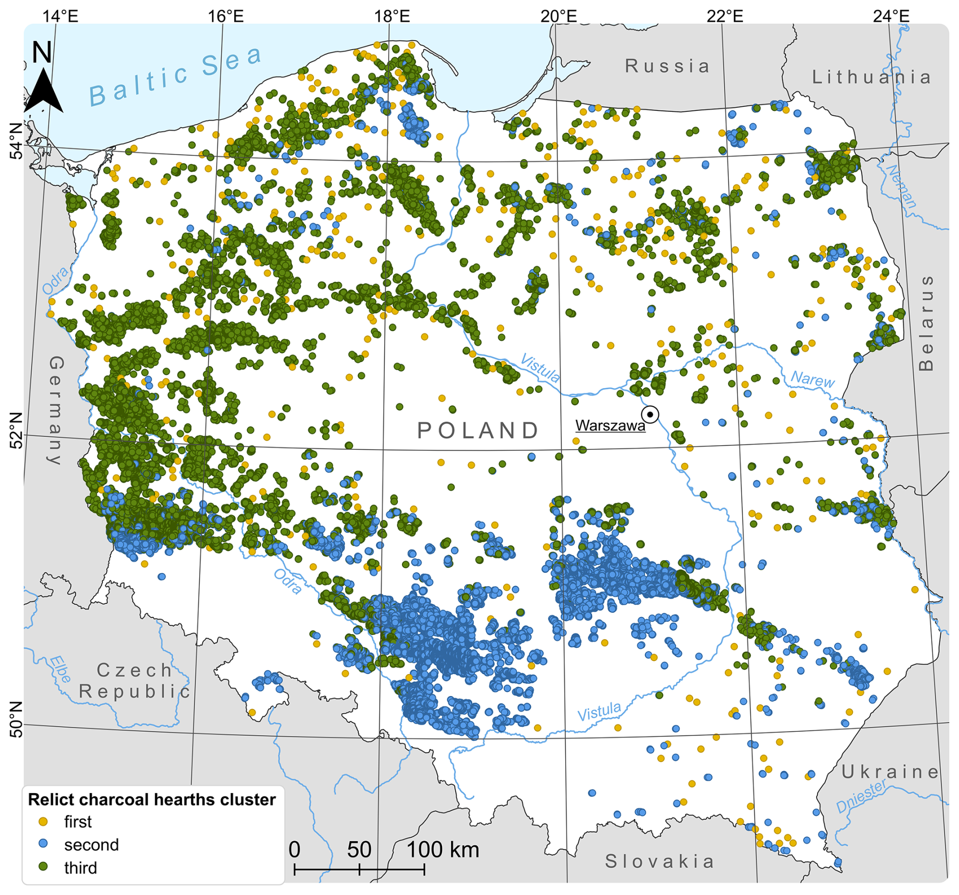
Figure 4Spatial distribution of three identified types of Relict Charcoal Hearths (RCHs) across Poland.
This three-cluster preference is further corroborated by a visual inspection of cluster maps (a map of a three-cluster only solution is presented below for brevity). Starting from a four-cluster solution, each new cluster merely becomes a spatial subset of one of the two large clusters evident in the three-cluster solution. For example, the third cluster in a three-cluster solution is divided into two clusters in a four-cluster solution, and the first cluster in the three and four-cluster solutions is divided into two clusters in the five-cluster solution. In other words, spatial intermixing of clusters never occurs as the number of clusters increases.
Additional support for a three-cluster solution comes from an analysis of cluster characteristics. Table 1 provides details on these characteristics, based on mode values and mean z-scores. Cluster 2 is distinct from the others, as it contains only 338 hearths and differs in potential vegetation. Moreover, the characteristics of the clusters beyond the three-cluster solution are driven mainly by numerical variables, as the mode values remain largely unchanged. In the three-cluster solution, clusters 1 and 3 share similar environmental characteristics, and these characteristics remain largely constant regardless of the number of clusters considered, further validating the suitability of a three-cluster approach.
Table 1Modes and z-score means (minimum and maximum values highlighted) across clusters for a three-cluster solution.
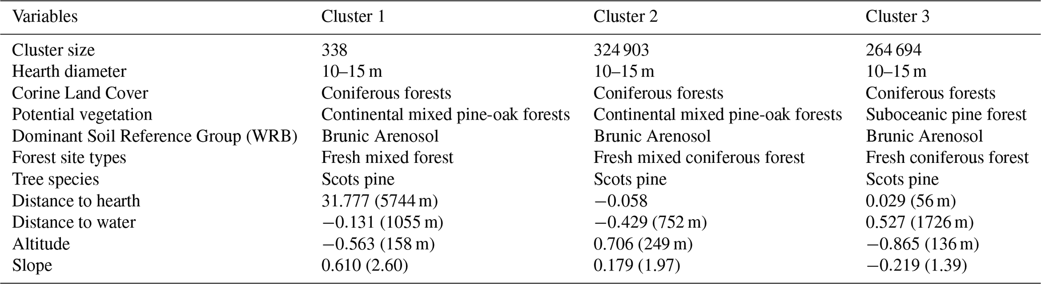
Cluster characteristics are based on modes as well as the highest and lowest z-scores. Cluster 1 contains medium-sized hearths located in pine forests, close to other hearths, far from rivers and lakes, on gentle slopes and at low altitudes. Cluster 2 contains medium-sized hearths found in mixed forests, isolated from other hearths, and on steep slopes. Cluster 3 contains medium-sized hearths located in pine forests, in close proximity to other hearths, and at high altitudes on steeper slopes.
All data generated and analyzed during this study are publicly available through the ZENODO repository: https://doi.org/10.5281/zenodo.15630690 (Słowiński et al., 2025). The dataset includes raw and processed results, metadata, and relevant documentation to ensure reproducibility. The ReCHAR database underlying this study is hosted and maintained by the Institute of Geography and Spatial Organization, Polish Academy of Sciences. This database is openly accessible; for inquiries regarding dataset structure, access support, or additional details, please contact michal.slowinski@igipz.pan.pl and aj.halas@twarda.pan.pl.
The database developed in this study is the first comprehensive, high-resolution spatial dataset documenting remnants of historical charcoal production in the form of Relict Charcoal Hearths across an entire country (Słowiński et al., 2025). To our knowledge, there is currently no equivalent dataset of this scale and resolution available elsewhere in Europe or globally. While regional charcoal hearth inventories do exist, none offer the systematic national coverage, environmental context, and object-level detail provided here.
The ReCHAR dataset provides substantial value across a wide range of disciplines, including soil science, forestry, ecology, environmental history, archaeology, anthropology, and cultural heritage studies. It not only preserves evidence of past forest use but also enables new insights into long-term human impacts on forest ecosystems, soil transformation processes, and landscape change.
The current version of the database includes 634 815 georeferenced entries, categorized by hearth size (small: <10 m; medium: 10–15 m; large: >15 m), and enriched with information on current and potential vegetation, topography, proximity to water bodies, and soil types. The dataset was intentionally designed with a simple structure to ensure broad compatibility, but its modular design allows for continuous expansion and integration with other spatial datasets.
Importantly, future iterations of the ReCHAR database will also aim to incorporate other data types – such as the historical names and locations of villages, hamlets, or industrial sites directly associated with charcoal production and related industries. These include glassworks, iron smelters, potash and tar distilleries – industries that would not have existed without wood and, later, charcoal as a primary fuels and chemical inputs. By connecting spatial traces of forest exploitation with the socio-economic infrastructure it sustained, the database will support deeper investigations into early industrialization, rural economies, and environmental transformations.
The long-term vision of the ReCHAR project is to develop an open-access, community-driven research platform supporting the documentation, analysis, and exchange of data related to anthropogenic forest disturbances and spatial landscape history. Development priorities include: (1) integration of interactive visualization tools, (2) a user-friendly interface for data submission and review, and (3) the inclusion of extended metadata to enable more detailed scientific analyses.
We invite researchers, practitioners, and forest managers to contribute additional datasets, share their expertise, and co-develop analytical tools using this resource. Ultimately, ReCHAR is envisioned as a foundational platform for interdisciplinary, spatially informed research into human–environment interactions over long timescales – locally, regionally, and globally.
Supplementary Fig. S1: Visibility of Relict Charcoal Hearth microrelief in ALS-derived bare-earth DTM: effect of illumination azimuth (45, 135, 225, 315°) and vertical exaggeration (Z=1–4); example site (54°6′40′′ N; 16°28′ E). Supplementary Fig. S2: Map of the spatial density of relict charcoal hearths across forested areas of Poland (hearths km2). The supplement related to this article is available online at https://doi.org/10.5194/essd-18-493-2026-supplement.
KSz mapped charcoal hearths from lidar data, analyzed the data,authored or reviewed drafts of the paper, and approved the final draft. AH analyzed the data, prepared figures and tables, authored or reviewed drafts of the paper, and approved the final draft. MN analyzed the data and performed cluster analysis, prepared figures and tables, authored or reviewed drafts of the paper, and approved the final draft. DŁ analyzed the data, authored or reviewed drafts of the paper, and approved the final draft, ST analyzed the data, authored or reviewed drafts of the paper, and approved the final draft, AG analyzed the data, authored or reviewed drafts of the paper, and approved the final draft, JJ analyzed the data, authored or reviewed drafts of the paper, and approved the final draft, BK analyzed the data, authored or reviewed drafts of the paper, and approved the final draft, ACh analyzed the data, authored or reviewed drafts of the paper, and approved the final draft, SaS analyzed the data, authored or reviewed drafts of the paper, and approved the final draft, TP analyzed the data, authored or reviewed drafts of the paper, and approved the final draft, KSz analyzed the data, authored or reviewed drafts of the paper, and approved the final draft, DB analyzed the data, authored or reviewed drafts of the paper, and approved the final draft, JW proposed website and repository description for ReCHAR, authored or reviewed drafts of the paper, and approved the final draft, TS analyzed the data, authored or reviewed drafts of the paper, and approved the final draft, TZ analyzed the data, authored or reviewed drafts of the paper, and approved the final draft, BGN analyzed the data, authored or reviewed drafts of the paper, and approved the final draft, AK analyzed the data, authored or reviewed drafts of the paper, and approved the final draft, MK analyzed the data, authored or reviewed drafts of the paper, and approved the final draft, MS conceived and designed the project, analyzed the data, prepared figures and tables, authored or reviewed drafts of the paper, and approved the final draft.
The contact author has declared that none of the authors has any competing interests.
Publisher's note: Copernicus Publications remains neutral with regard to jurisdictional claims made in the text, published maps, institutional affiliations, or any other geographical representation in this paper. The authors bear the ultimate responsibility for providing appropriate place names. Views expressed in the text are those of the authors and do not necessarily reflect the views of the publisher.
We would like to express our sincere gratitude to all individuals and institutions who contributed to the realization of this research. We extend our special thanks to the staff of the Darwieński National Park. for their kindness, support, and understanding during the course of the fieldwork. We also wish to thank the State Forests (Lasy Państwowe) for their assistance and for their positive attitude toward the research activities carried out. Special thanks go to Dorota Żelechowska for her commitment and support during her internship, particularly in the initial development of the research database. Finally, we would like to note that, to improve the clarity and linguistic consistency of selected parts of the text, we used a language tool based on artificial intelligence (ChatGPT). These edits were purely linguistic and did not affect the scientific content of the work.
The research was funded by the National Science Centre projects, “Impact of charcoal production on environmental changes in Northern Poland – a novel “multi-proxy” approach” (grant no. 2018/31/B/ST10/02498) and “Anthropogenic transformations of the environment in the context of modernization processes of the Congress Poland” (grant no. 2022/47/D/HS3/02947) and “Forest of the Anthropocene: the role of Pinus sylvestris in the formation of modern states, societies and environments in the 18th and 19th centuries” (grant no. 2024/55/I/HS3/02551).
This paper was edited by Robert Jackisch and reviewed by two anonymous referees.
Bielenin, K.: Starożytne mielerze świętokrzyskiego hutnictwa żelaza, Kwartalnik Historii Kultury Materialnej, 7, 467–472, 1959.
Blackbourn, D.: The Conquest of Nature: Water, Landscape, and the Making of Modern Germany, Norton, ISBN-10:0393329992, 2006.
Bonhage, A., Raab, T., Schneider, A., Raab, A., Ouimet, W., Völkel, J., and Ramezany, S.: From site to state – Quantifying multi-scale legacy effects of historic landforms from charcoal production on soils in Connecticut, USA, Catena, 232, https://doi.org/10.1016/j.catena.2023.107426, 2023.
Broda, J.: History of forestry in Poland, Wydawnictwo Akademii Rolniczej w Poznaniu, Wydawnictwo, ISBN 83-7160-216-2, 2000.
Buras, A., Hirsch, F., van der Maaten, E., Takla, M., Räbiger, C., Cruz Garcia, R., Schneider, A., Raab, A., Raab, T., and Wilmking, M.: Charcoal kiln relicts – a favorable site for tree growth?, in: EGU, Vienna, EGU2015-3574-2, 2015.
Buras, A., Hirsch, F., Schneider, A., Scharnweber, T., van der Maaten, E., Cruz-Garcia, R., Raab, T., and Wilmking, M.: Reduced above-ground growth and wood density but increased wood chemical concentrations of Scots pine on relict charcoal hearths, Sci. Total Environ., 717, 137189, https://doi.org/10.1016/j.scitotenv.2020.137189, 2020.
Cembrzyński, P.: Miasta górnicze Europy Środkowowschodniej w XIII–XVII w., doctoral dissertation, Dokt. 2015/070, Jagiellonian University, Kraków, https://ruj.uj.edu.pl/entities/publication/47442c27-92dd-4f09-849f-bc13708b0457 (last access: 16 January 2026), 2014.
Ciceri, D., Manning, D. A., and Allanore, A.: Historical and technical developments of potassium resources, Sci. Total Environ., 502, 590–601, https://doi.org/10.1016/j.scitotenv.2014.09.013, 2015.
Cleere, H., Crossley, D. W., and Worssam, B. C.: The Iron Industry of the Weald, Leicester University Press, ISBN 1 898937 04 4, 1985.
Codreanu-Windauer, S.: Holzkohlenmeiler-vergessene Denkmaler?, Erfassung und Bewertung von vorindustriellen Meilerstandorten-Workshop, 19 Februar 2019, 143–157, https://opus4.kobv.de/opus4-btu/frontdoor/deliver/index/docId/4817/file/GeoRS_Vol_8.pdf (last access: 16 January 2026), 2019.
Davis, D. S. and Lundin, J.: Locating Charcoal Production Sites in Sweden Using LiDAR, Hydrological Algorithms, and Deep Learning, Remote Sens., 13, https://doi.org/10.3390/rs13183680, 2021.
der Vaart, W. V. v., Bonhage, A., Schneider, A., Ouimet, W., and Raab, T.: Automated large-scale mapping and analysis of relict charcoal hearths in Connecticut (USA) using a Deep Learning YOLOv4 framework, Archaeolog. Prospect., 30, 251–266, https://doi.org/10.1002/arp.1889, 2022.
Dupin, A., Girardclos, O., Fruchart, C., Laplaige, C., Nuninger, L., Dufraisse, A., and Gauthier, E.: Anthracology of charcoal kilns in the forest of Chailluz (France) as a tool to understand Franche-Comte forestry from the mid-15th to the early 20th century AD, Quatern. Int., 458, 200–213, https://doi.org/10.1016/j.quaint.2017.03.008, 2017.
Ebert, B.: Learning from the Past: Rediscovering Traditional Medieval Wood Tar Adhesives for Sustainable Stone Conservation and Built Heritage, Stud. Conserv., 69, 63–71, https://doi.org/10.1080/00393630.2024.2339728, 2024.
Ellis, E. C.: Land Use and Ecological Change: A 12,000-Year History, Annu. Rev. Environ. Resour., 46, 1–33, https://doi.org/10.1146/annurev-environ-012220-010822, 2021.
European Environment Agency: CORINE Land Cover 2018 (version 2020_20u1), Copernicus Land Monitoring Service [data set], https://doi.org/10.2909/71c95a07-e296-44fc-b22b-415f42acfdf0, 2020.
European Space Agency: Environmental assessment report, https://www.esa.int/About_Us/ESA_Annual_Report_2020 (last access: 16 January 2026), 2000.
Fokt, K.: Późnośredniowieczne osadnictwo wiejskie na Dolnym Śląsku w świetle badań archeologicznych [Late medieval rural settlement in Lower Silesia in the light of archaeological research], Księgarnia Akademicka, Kraków, ISBN 9788376382067, 2012.
Gałka, B., Podlaska, M., and Kabała, C.: Siedliskotwórcze właściwości gleb brunatnych kwaśnych wytworzonych z granitoidów w Górach Stołowych, Sylwan, 157, 385–394, 2013.
Garbarino, M., Morresi, D., Meloni, F., Anselmetto, N., Ruffinatto, F., and Bocca, M.: Legacy of wood charcoal production on subalpine forest structure and species composition, Ambio, 51, 2496–2507, https://doi.org/10.1007/s13280-022-01750-y, 2022.
Geopartal: Map of Relief Shading (WMTS), Geopartal [data set], https://www.geoportal.gov.pl/en/services/view-services-wms-and-wmts/ (last access: 16 January 2026), 2025.
Groenewoudt, B.: Charcoal burning and landscape dynamics in the Early Medieval Netherlands, Ruralia VI, 327–337, https://doi.org/10.1484/M.RURALIA-EB.3.1150, 2005.
Groenewoudt, B. and Spek, T.: Woodland Dynamics as a Result of Settlement Relocation on Pleistocene Sandy Soils in the Netherlands (200 BC–AD 1400), Rural Landsc.: Soc. Environm. Hist., 3, https://doi.org/10.16993/rl.20, 2016.
Hardy, B., Cornelis, J. T., Houben, D., Leifeld, J., Lambert, R., and Dufey, J. E.: Evaluation of the long-term effect of biochar on properties of temperate agricultural soil at pre-industrial charcoal kiln sites in Wallonia, Belgium, Eur. J. Soil Sci., 68, 80–89, https://doi.org/10.1111/ejss.12395, 2017.
Hensel, W., Pazdur, J., Dembińska, M., Podwińska, Z., Rutkowska-Płachcińska, A., Keckowa, A., Molenda, D., Kamieńska, Z., Baranowski, B., and Kowecka, E.: Historia kultury materialnej Polski w zarysie: opracowanie zbiorowe, t. 1–6, Zakład Narod. im. Ossolińskich, ISBN 830400433X, 1978.
Hirsch, F., Raab, T., Ouimet, W., Dethier, D., Schneider, A., and Raab, A.: Soils on Historic Charcoal Hearths: Terminology and Chemical Properties, Soil Sci. Soc. Am. J., 81, 1427–1435, https://doi.org/10.2136/sssaj2017.02.0067, 2017.
Hirsch, F., Schneider, A., Bauriegel, A., Raab, A., and Raab, T.: Formation, Classification, and Properties of Soils at Two Relict Charcoal Hearth Sites in Brandenburg, Germany, Fron. Environ. Sci., 6, https://doi.org/10.3389/fenvs.2018.00094, 2018.
Hirsch, F., Schneider, A., Bonhage, A., Raab, A., Drohan, P. J., and Raab, T.: An initiative for a morphologic-genetic catalog of relict charcoal hearths from Central Europe, Geoarchaeology, 35, 974–983, https://doi.org/10.1002/gea.21799, 2020.
Huang, Z. X.: Extensions to the means algorithm for clustering large data sets with categorical values, Data Min. Knowl. Discov., 2, 283–304, https://doi.org/10.1023/A:1009769707641, 1998.
IUSS Working Group WRB: World reference base for soil resources, in: International soil classification system for naming soils and creating legends for soil maps, 4th Edn., IUSS – International Union of Soil Sciences, https://www3.ls.tum.de/boku/?id=1419 (last access: 15 January 2026), 2022.
Jankowski, M., Przewoźna, B., and Bednarek, R.: Topographical inversion of sandy soils due to local conditions in Northern Poland, Geomorphology, 135, 277–283, https://doi.org/10.1016/j.geomorph.2011.02.005, 2011.
Jonczak, J., Barbarino, V., Chojnacka, A., Kruczkowska, B., Szewczyk, K., Gmińska-Nowak, B., Kołaczkowska, E., Łuców, D., Halaś, A., Mroczkowska, A., Słowińska, S., Kramkowski, M., Kowalska, A., and Słowiński, M.: Historical charcoal production as a factor in soil cover heterogeneity in a fluvioglacial landscape – A case study from northern Poland, Geoderma, 445, https://doi.org/10.1016/j.geoderma.2024.116892, 2024.
Kabała, C., Charzyński, P., Chodorowski, J., Drewnik, M., Glina, B., Greinert, A., Hulisz, P., Jankowski, M., Jonczak, J., Łabaz, B., Łachacz, A., Marzec, M., Mendyk, Ł., Musiał, P., Musielok, Ł., Smreczak, B., Sowiński, P., Świtoniak, M., Uzarowicz, Ł., and Waroszewski, J.: Polish Soil Classification, 6th edition – principles, classification scheme and correlations, Soil Sci. Annual, 70, 71–97, https://doi.org/10.2478/ssa-2019-0009, 2019.
Kabała, C., Ksepko, M., and Musiał, P.: Typological and physicochemical variability of rusty soils (Brunic Arenosols) in the Bialowieża Forests, eastern Poland, Soil Sci. Annual, 72, 1–14, https://doi.org/10.37501/soilsa/143900, 2021.
Kacprzak, A. and Derkowski, A.: Cambisols developed from cover-beds in the Pieniny Mts. (southern Poland) and their mineral composition, Catena, 71, 292–297, https://doi.org/10.1016/j.catena.2007.01.004, 2007.
Kałagate, S., Osypiński, P., and Stachowiak, P.: Relikty późnonowożytnego mielerza odkryte na stanowisku nr 4 w Wilkowie, gm, Świdnica, pow. zielonogórski, woj. lubuskie, Archeologia Środkowego Nadodrza, 9, 241–249, 2012.
Klein, P. and Bauch, J.: Aufbau einer Jahrringchronologie für Buchenholz und ihre Anwendung für die Datierung von Gemälden, Holzforschung, De Gruyter Brill, 35–39, https://doi.org/10.1515/hfsg.1983.37.1.35, 1983.
Kottek, M., Grieser, J., Beck, C., Rudolf, B., and Rubel, F.: World map of the Köppen–Geiger climate classification updated, https://doi.org/10.1127/0941-2948/2006/0130, 2006.
Lasota, J., Błońska, E., and Pacanowski, P.: Forest sites and forest types on rendzinas in Poland, Soil Sci. Annual, 69, 121–129, https://doi.org/10.2478/ssa-2018-0012, 2018.
Lasota, J., Błońska, E., Babiak, T., Piaszczyk, W., Stępniewska, H., Jankowiak, R., Boroń, P., and Lenart-Boroń, A.: Effect of Charcoal on the Properties, Enzyme Activities and Microbial Diversity of Temperate Pine Forest Soils, Forests, 12, https://doi.org/10.3390/f12111488, 2021.
Liedekerke, M., Jones, A., and Panagos, P.: ESDBv2 Raster Library [Data set], Derived from the European Soil Database distribution v2.0, EUR 19945 EN, CD-ROM, European Commission & European Soil Bureau Network [data set], https://esdac.jrc.ec.europa.eu/content/european-soil-database-v2-raster-library-1kmx1km (last access: 16 January 2026), 2006.
Ludemann, T.: Airborne laser scanning of historical wood charcoal production sites – A new tool of kiln site anthracology at the landscape level, Wood and charcoal evidence for human and natural history, Papeles del Laboratorio de Arqueología de Valencia, Laboratorio de Arqueología de Valencia, 2012.
Marks, L.: Last Glacial Maximum in Poland, Quaternary Sci. Rev., 21, 103–110, https://doi.org/10.1016/S0277-3791(01)00086-5, 2002.
Marks, L.: Pleistocene river systems in the southern peribaltic area as indication of interglacial sea level changes in the Baltic Basin, Quatern. Int., 130, 43–48, https://doi.org/10.1016/j.quaint.2004.04.029, 2005.
Marszałek, E. and Kusiak, W.: Wypałwe?gla drzewnego w Bieszczadach w przeszłosìci i obecnie, Roczniki Bieszczadzkie, 21, 164–183, 2013.
Matuszkiewicz, J. M.: Potential natural vegetation of Poland, IGiPZ PAN, Warszawa, https://www.igipz.pan.pl/potential-vegetation-dge.html (last access: 16 January 2026), 2008.
Matuszkiewicz, J. M. and Wolski, J.: Potential natural vegetation of Poland (vector version), IGSO PAS, Warszawa, https://www.igipz.pan.pl/potential-vegetation-dge.html (last access: 16 January 2026), 2023.
Matuszkiewicz, W.: Szata roślinna, in: Geografia Polski Środowisko Przyrodnicze, edited by: Starkel, L., Wydawnictwo Naukowe PWN, Warszawa, 427–475, ISBN 8301096217, 1999.
Matuszkiewicz, W., Faliński, J. B., Kostrowicki, A. S., Matuszkiewicz, J. M., Olaczek, R., and Wojterski, T.: Potential natural vegetation of Poland, General map 1:300 000, IGSO PAS, Warszawa, https://www.igipz.pan.pl/potential-vegetation-dge.html (last access: 16 January 2026), 1995.
Miechówka, A. and Drewnik, M.: Rendzina soils in the Tatra Mountains, central Europe: a review, Soil Sci. Annual, 69, 88–100, https://doi.org/10.2478/ssa-2018-0009, 2018.
Mikulski, K.: Osadnictwo wiejskie województwa pomorskiego od połowy XVI do końca XVII wieku, v. 86, pt. 2, Towarzystwo Naukowe w Toruniu, ISBN 83-85196-05-6, 1994.
Oliveira, C., Aravecchia, S., Pradalier, C., Robin, V., and Devin, S.: The use of remote sensing tools for accurate charcoal kilns' inventory and distribution analysis: Comparative assessment and prospective, Int. J. Appl. Earth Obs. Geoinf., 105, https://doi.org/10.1016/j.jag.2021.102641, 2021.
Panagos, P.: The European soil database, GEO: connexion, 5, 32–33, 2006.
Paschalis, P.: O węglach do hut i kuźnic [About charcoal for steel mills and forges], Sylwan, 41–46, https://bibliotekanauki.pl/articles/824464 (last access: 16 January 2026), 1973.
Pierik, H. J., van Lanen, R. J., Gouw-Bouman, M. T., Groenewoudt, B. J., Wallinga, J., and Hoek, W. Z.: Controls on late-Holocene drift-sand dynamics: The dominant role of human pressure in the Netherlands, Holocene, 28, 1361–1381, https://doi.org/10.1177/0959683618777052, 2018.
Przybylski, P., Związek, T., Kowalczyk, J., and Słowiński, M.: Research perspectives on historical legacy of the Scots pine (Pinus sylvestris L.): Genes as the silent actor in the transformation of the Central European forests in the last 200 years, Elem. Sci. Anth., 13, https://doi.org/10.1525/elementa.2024.00041, 2025.
Raab, A., Takla, M., Raab, T., Nicolay, A., Schneider, A., Rösler, H., Heußner, K. U., and Bönisch, E.: Pre-industrial charcoal production in Lower Lusatia (Brandenburg, Germany): Detection and evaluation of a large charcoal-burning field by combining archaeological studies, GIS-based analyses of shaded-relief maps and dendrochronological age determination, Quatern. Int., 367, 111–122, https://doi.org/10.1016/j.quaint.2014.09.041, 2015a.
Raab, T., Raab, A., Nicolay, A., Takla, M., Hirsch, F., Rösler, H., and Bauriegel, A.: Opencast mines in South Brandenburg (Germany) – archives of Late Quaternary landscape development and human-induced land use changes, Archaeolog. Anthropolog. Sci., 8, 453–466, https://doi.org/10.1007/s12520-015-0227-6, 2015b.
Rokach, L. and Maimon, O.: Clustering Methods, in: Data Mining and Knowledge Discovery Handbook, edited by: Maimon, O., and Rokach, L., Springer US, Boston, MA, 321–352, https://doi.org/10.1007/0-387-25465-X_15, 2005.
Rutkiewicz, P., Malik, I., Wistuba, M., and Osika, A.: High concentration of charcoal hearth remains as legacy of historical ferrous metallurgy in southern Poland, Quatern. Int., 512, 133–143, https://doi.org/10.1016/j.quaint.2019.04.015, 2019.
Rutkiewicz, P., Kalicki, T., Kłusakiewicz, E., and Przepióra, P.: Historical Charcoal Burning in the Kamienna River Basin (Old Polish Industrial District, Central Poland) – First Results from Lidar Data, Acta Geobalcan., 8, 103–108, https://doi.org/10.18509/AGB218-3103r, 2021.
Samojlik, T., Rotherham, I. D., and Jedrzejewska, B.: Quantifying Historic Human Impacts on Forest Environments: A Case Study in Bialowieza Forest, Poland, Environ. Hist., 18, 576–602, https://doi.org/10.1093/envhis/emt039, 2013a.
Samojlik, T., Jędrzejewska, B., Michniewicz, M., Krasnodębski, D., Dulinicz, M., Olczak, H., Karczewski, A., and Rotherham, I. D.: Tree species used for low-intensity production of charcoal and wood-tar in the 18th-century Białowieża Primeval Forest, Poland, Phytocoenologia, 43, 1–12, https://doi.org/10.1127/0340-269x/2013/0043-0511, 2013b.
Schneider, A., Hirsch, F., Raab, A., and Raab, T.: Temperature Regime of a Charcoal-Enriched Land Use Legacy Soil, Soil Sci. Soc. Am. J., 83, 565–574, https://doi.org/10.2136/sssaj2018.12.0483, 2019.
Schneider, A., Bonhage, A., Hirsch, F., Raab, A., and Raab, T.: Hot spots and hot zones of soil organic matter in forests as a legacy of historical charcoal production, Forest Ecol. Manage., 504, https://doi.org/10.1016/j.foreco.2021.119846, 2022.
Słowiński, M., Lamentowicz, M., Luców, D., Barabach, J., Brykała, D., Tyszkowski, S., Pieńczewska, A., Śnieszko, Z., Dietze, E., Jazdżewski, K., Obremska, M., Ott, F., Brauer, A., and Marcisz, K.: Paleoecological and historical data as an important tool in ecosystem management, J. Environ. Manage., 236, 755–768, https://doi.org/10.1016/j.jenvman.2019.02.002, 2019.
Słowiński, M., Szewczyk, K., Łuców, D., Róg, D., Konopski, M., Słowińska, S., Kruczkowska, B., Jonczak, J., Gmińska-Nowak, B., Noryśkiewicz, A. M., Kołaczkowska, E., Tyszkowski, S., Swoboda, P., Chojnacka, A., Brykała, D., Kowalska, A., Barbarino, V., Kardasz, C., Niedzielski, M., Halaś, A., Kramkowski, M., Związek, T., Ważny, T., Mroczkowska, A., and Obremska, M.: A novel multiproxy approach to detect the impact of charcoal production on the natural environment in NW Poland – project concept and preliminary results, Geographia Polonica, 95, 205–225, https://doi.org/10.7163/GPol.0233, 2022.
Słowiński, M., Związek, T., Swoboda, P., Niedzielski, M. A., Słowińska, S., Konopski, M., Jonczak, J., Kruczkowska, B., Chojnacka, A., Róg, D., Szewczyk, K., and Brykała, D.: Human impacts on environment in the preindustrial forest landscapes in Poland – An overview, Elem. Sci. Anth., 12, https://doi.org/10.1525/elementa.2023.00065, 2024.
Słowiński, M., Halaś, A., Niedzielski, M., Szewczyk, K., Jonczak, J., Luców, D., Tyszkowski, S., Słowińska, S., Gruszczyńska, A., Kruczkowska, B., Chojnacka, A., Polkowski, T., Sztabkowski, K., Brykała, D., Wolski, J., Samojlik, T., Kaszkiel, A., Gminska-Nowak, B., and Związek, T.: ReCHAR database – spatial distribution of relict charcoal hearths across Poland [data set], Zenodo [data set], https://doi.org/10.5281/zenodo.15630690, 2025.
Smil, V.: Energy and Civilization: A History, MIT Press, ISBN 9780262338301, https://doi.org/10.7551/mitpress/10752.001.0001, 2017.
Solon, J., Borzyszkowski, J., Bidłasik, M., Richling, A., Badora, K., Balon, J., Brzezińska-Wójcik, T., Chabudziński, Ł., Dobrowolski, R., Grzegorczyk, I., Jodłowski, M., Kistowski, M., Kot, R., Krąż, P., Lechnio, J., Macias, A., Majchrowska, A., Malinowska, E., Migoń, P., Myga-Piątek, U., Nita, J., Papińska, E., Rodzik, J., Strzyż, M., Terpiłowski, S., and Ziaja, W.: Physico-geographical mesoregions of Poland: Verification and adjustment of boundaries on the basis of contemporary spatial data, Geographia Polonica, 91, 143–170, https://doi.org/10.7163/GPol.0115, 2018.
Suh, J. W., Anderson, E., Ouimet, W., Johnson, K. M., and Witharana, C.: Mapping Relict Charcoal Hearths in New England Using Deep Convolutional Neural Networks and LiDAR Data, Remote Sens., 13, https://doi.org/10.3390/rs13224630, 2021.
Suh, J. W., Ouimet, W. B., and Dow, S.: Reconstructing and identifying historic land use in northeastern United States using anthropogenic landforms and deep learning, Appl. Geogr., 161, 103121, https://doi.org/10.1016/j.apgeog.2023.103121, 2023.
Surowiecki, W.: O Rzekach Y Spławach Kraiów Xięstwa Warszawskiego z Zlecenia JW, Łubieńskiego, https://www.wbc.poznan.pl/dlibra/publication/17914/edition/29141/content (last access: 16 January 2026), 1811.
Waga, J. M., Szypuła, B., Sendobry, K., and Fajer, M.: Ślady działalności człowieka na terenach leśnych Parku Krajobrazowego “Cysterskie Kompozycje Krajobrazowe Rud Wielkich” odczytane z obrazów LiDAR oraz ich znaczenie w ochronie dziedzictwa kulturowego i przyrodniczego, Czasopismo Geograficzne, 93, 107–138, https://doi.org/10.12657/czageo-93-05, 2022.
White, J. C.: On the Use of Potash in Some Cutaneous Diseases, Boston Med. Surg. J., 61, 229–233, https://doi.org/10.1056/NEJM185910200611201, 1859.
Witharana, C., Ouimet, W. B., and Johnson, K. M.: Using LiDAR and GEOBIA for automated extraction of eighteenth–late nineteenth century relict charcoal hearths in southern New England, GIScience Remote Sens., 55, 183–204, https://doi.org/10.1080/15481603.2018.1431356, 2018.
Związek, T., Łuców, D., Popek, J., Klisz, M., Obremska, M., Sobechowicz, Ł., Solon, J., Słowiński, M., Przybylski, P., Tyburski, Ł., Zin, E., Jastrzębowski, S., Płaczkowska, E., Pilch, K., Szewczyk, K., Konczal, A. A., Rutkowski, P., Główka, D., and Swoboda, P.: Addressing multiple perspectives in studying environmental changes in forest landscapes during the modernization period (18th–19th centuries), Anthrop. Rev., 11, 302–328, https://doi.org/10.1177/20530196231205485, 2023.