the Creative Commons Attribution 4.0 License.
the Creative Commons Attribution 4.0 License.
 | 20 Nov 2025
Monitoring abiotic and biotic parameters of forest regrowth under different management regimes on former wildfire sites in northeastern Germany – data from the PYROPHOB project
Marie-Therese Schmehl
Yojana Adhikari
Cathrina Balthasar
Anja Binder
Danica Clerc
Sophia Dobkowitz
Werner Gerwin
Kristin Günther
Heinrich Hartong
Thilo Heinken
Carsten Hess
Pierre L. Ibisch
Florent Jouy
Loretta Leinen
Thomas Raab
Frank Repmann
Susanne Rönnefarth
Lilly Rohlfs
Marina Schirrmacher
Jens Schröder
Maren Schüle
Andrea Vieth-Hillebrand
Till Francke
We present the data recorded by eight institutions within the PYROPHOB project, running from 2020 to 2024 at two forest research sites in the south-west of Brandenburg, Germany. The aim of the project was to monitor abiotic and biotic parameters of forest regrowth under different management regimes on former wildfire sites in northeastern Germany. The observations comprised intermittent and continuous measurements or surveys on meteorological parameters (rainfall, temperature, vapour pressure deficit), soil (soil type and texture, soil chemistry and leaching, water content, soil temperature), deadwood, stand structure, vegetation regrowth, abundance of selected fauna (moths, beetles, mammals), UAV-based remote sensing (stand structure, spatial overview), and photo monitoring (succession). Thus, the multitude of collected data allows not only for detailed analyses of these observables separately, but also considering their interaction for a more multidisciplinary view on forest recovery after a wildfire. The data are available under the following DOIs: https://doi.org/10.23728/b2share.08a6a8b56f774a08a984871e7ef1b5a8 (Part 1, Schmehl et al., 2025a), under embargo until 31 March 2026 (Part 2, Schmehl et al., 2025b), https://doi.org/10.23728/b2share.de1661761da5481f938caf460e4f0ca9 (Part 3.1, Schmehl et al., 2025c), and https://doi.org/10.23728/b2share.51bdf4b6dc854873b6ff44fdddbf4c3b (Part 3.2, Schmehl et al., 2025d).
- Article
(3072 KB) - Full-text XML
- BibTeX
- EndNote


1.1 Background and context
Forests provide numerous ecosystem services essential for natural systems and society. However, they have experienced increasing stress over recent years, mainly due to climate change, natural disasters (i.e. heavy storms and wildfires), shifting species composition, and invasive species (Ayres et al., 2014), some of them even interlinked. Consequently, managing forests in a way that improves their resilience against these hazards is a major challenge. Adapted management comprises not only the time period before the above-mentioned hazards arise, but also after their occurrence for restoring the damaged ecosystems and enhancing their future stability. Because of the related long-term impact in forest systems, any of the related management decisions are of particular importance.
Among the above-mentioned hazards, wildfires present one of the most fundamental threats, as they potentially obliterate biological materials entirely. A high-intensity wildfire causes substantial economic losses and severely impairs the ecosystem services of the affected area. The recognition of the risk associated with wildfires and the importance of managing affected forests has grown in recent years, especially with regard to increased pressure on forest functions due to climate change (Stevens-Rumann et al., 2018). However, there is still a considerable shortage in datasets looking at post-fire forest development (Zang et al., 2024). Forest ecosystems comprise an intricate spectrum of relevant processes and interactions across multiple disciplines (e.g., forestry, botany, entomology, hydrology, soil science, etc.). However, research on forest recovery tends to focus on specific topics such as soil (e.g., Naethe et al., 2018; Klose and Makeschin, 2005), nutrients (e.g., Li et al., 2024), stand structure (e.g., Tesha et al., 2024), soil and vegetation (e.g., Gustafsson et al., 2021), soil microbiology (e.g., Yang et al., 2024), insects (e.g., Schauermann, 1980), or climate conditions (e.g., Wolf et al., 2021), which hinders a holistic assessment of the relevant processes, i.e., an analysis across disciplines. More importantly, the associated data are not always publicly accessible to allow for reproducible or follow-up research. Notable exceptions include, e.g., the work of Zang et al. (2024), having assembled a comprehensive dataset for burnt sites based on remote sensing techniques. While such remote sensing-based datasets excel at their spatial extent and potentially global coverage, they are, obviously, restricted to properties obtainable from spectral imagery, which excludes most of the above-mentioned specific topics as they require onsite surveys.
Specifically for temperate regions, post-wildfire related studies sharing their data are scarce (Jackisch et al., 2023, as an exception). To our best knowledge, no comprehensive, multidisciplinary dataset covering different management options is available.
On the other hand, sophisticated long-term monitoring for forest sites does exist (e.g., the long-term monitoring ICP forest sites, see Michel, 2022). While such dedicated observations provide invaluable information on forest development in the long term, they are evidently not designed for an immediate onset of monitoring following an unplanned catastrophic event such as a wild fire.
PYROPHOB (project duration: 2021–2025) is an interdisciplinary research project aiming to fill this gap. It focuses on studying the effects of forest fires and subsequent management strategies in pine forests in Brandenburg, north-east Germany. While fires in pine stands cause high tree mortality and alter soil properties, the knowledge at ecosystem-level about their effects is limited. The project is targeted at understanding how different components of biodiversity interact in post-fire ecosystems and how management strategies affect these interactions. In Central Europe, post-fire forest areas are typically managed through interventions like salvage logging and soil preparation. PYROPHOB explicitly considers a wider selection of management options (see also Table 1) to assess their impact on natural regeneration and other related environmental variables.
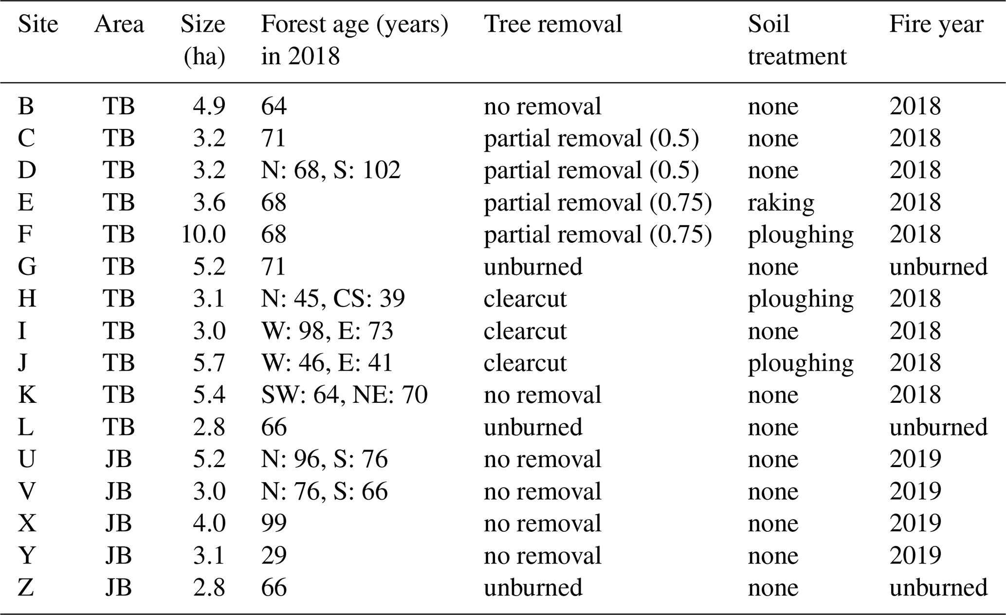
Table 1Overview of site attributes and their basic treatments. The age of the burned pine stands was determined using forestry data and checked in the field by counting growth rings on tree stumps if possible (C: Central, E: East, N: North, S: South, W: West). Partial removal means that either 50 % (0.5) or 75 % (0.75) of standing trees were removed. Aggregated from Heinken et al. (2024).
In this data paper, we present the broad range of data collected during the project. The paper is linked to an accompanying repository that ensures public access to these data and their long-term storage. In that context, this paper is intended to give a comprehensive overview of the shared data, and provide them in a consistent way. It also offers an overview of relevant other data sources and the scientific research done on the data so far. It does not – and cannot – summarize the scientific findings of the entire project.
1.2 Study goals and study design
The project investigates ecosystem components and their interactions in burned study sites, focusing on the effects of different forest management treatments on post-fire development. Key research questions include how forest fires change abiotic and biotic factors, how management treatments affect these factors, and how quickly new forests can be developed to be less vulnerable to fire. These different treatments were observed on dedicated “sites”, each representing a specific management practice. On each site, the project uses a system of standardized sample plots to allow for spatially consistent analyses across environmental factors, taxa, and management types.
1.3 Structure of this paper
This paper presents data from the majority of the research activities conducted within the PYROPHOB project between June 2020 and April 2025. Eight involved research institutions contributed to this dataset. However, some topics (i.e., fungi, predatory soil arthropods) are not included in this collection. We selected the data included in this selection mainly guided by their uniqueness, scientific interest, and potential value for subsequent analyses and re-use.
The study area, plot design and specific methodology have been described in high detail in Heinken et al. (2024). Therefore, we limit the information here to a minimum needed to understand the published data structure. Likewise, various dedicated scientific studies have already been conducted on the data, which are summarized in Sect. 5 and which cannot be covered here. Consequently, this paper is intended as a data paper, exclusively focusing on the presentation of the data.
The study area is introduced in Sect. 2.1; the acquisition and, partly, the processing of the included subsets of the data are documented in Sect. 3. Other potentially relevant data from third parties are listed in Sect. 4. Section 5 provides a brief overview of the already published studies related to the presented data, also outlining research perspectives with regard to the published data set. The paper closes with the conclusions in Sect. 7 reflecting on limitations of the dataset.
2.1 Study area
The PYROPHOB project was carried out in two large burned Scots pine forest areas in Brandenburg, northeastern Germany, about 50 km southwest of Berlin (see Fig. 1). Both areas are spatially distinct, unconnected (approx. 10 km apart), and are further referred to as “Treuenbrietzen” (TB) and “Jüterbog” (JB), named after the towns nearby.
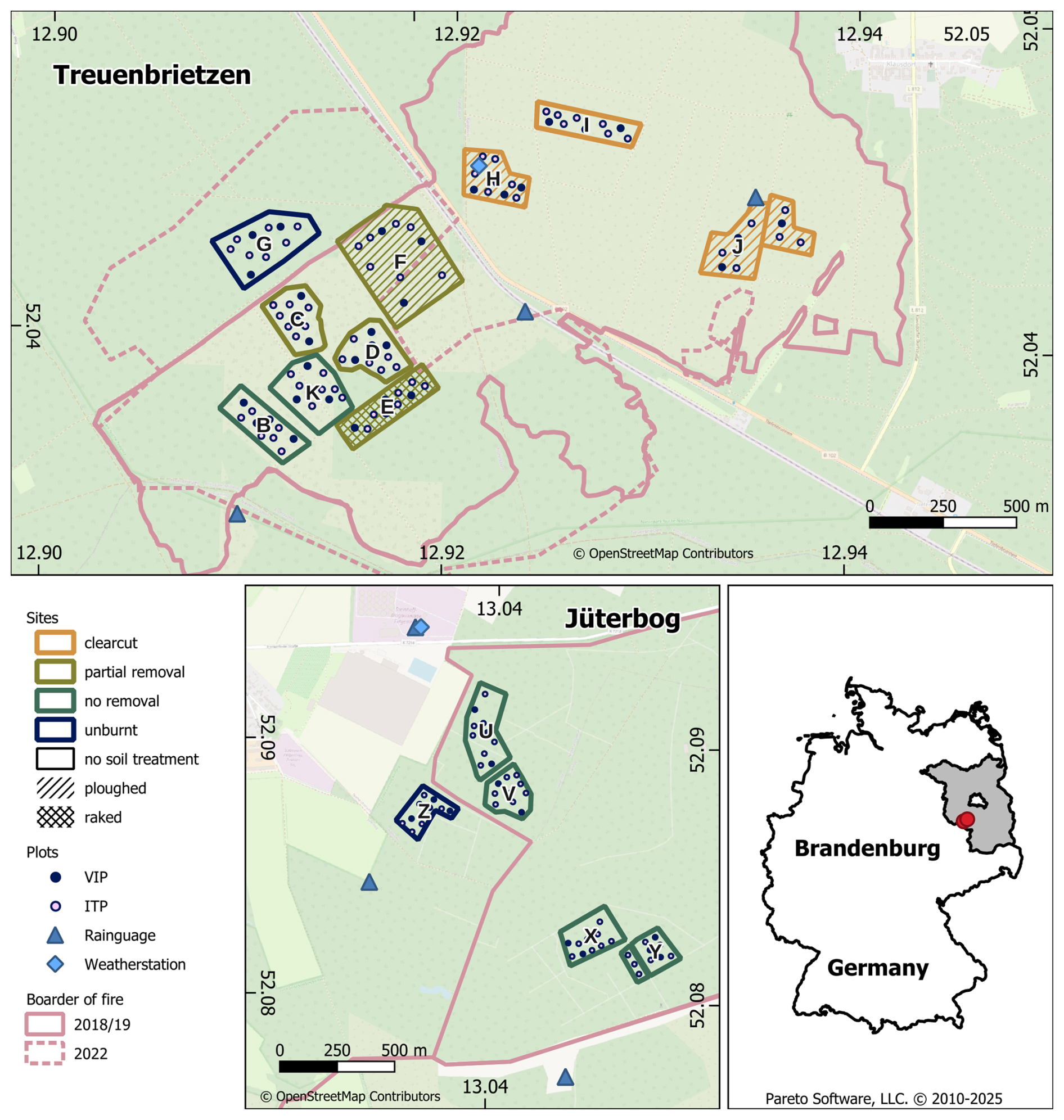
Figure 1Overview of the to study areas Treuenbrietzen (TB) and Jüterbog (JB) with the location of the sites with different forest management, and the included plots, marking the points of measurement.
The region is characterized by dry, sandy soils and a climate between Atlantic and continental, with the vegetation mainly consisting of Scots pine, various herb species, and dense bryophyte layers.
Treuenbrietzen (TB) experienced a forest fire in late August 2018, which destroyed 334 ha of pine stands, aged between 39 and 102 years (see Table 1). After the fire, different silvicultural treatments were applied, including salvage logging, planting various tree species, and leaving certain parts untreated. Some areas were fenced off to protect them from wildlife damage. In mid June 2022, a second fire occurred in TB, which affected nearly the whole formerly burnt area south of the dividing national road, and affected approximately 180 ha.
The second study area, near Jüterbog (JB), is located on a former military training ground converted into a wilderness area managed by the Brandenburg Wilderness Foundation. The foundation focuses on wilderness development and natural processes, corresponding to minimal intervention. JB was affected by a large wildfire in June 2019, which burned 744 ha of pine and mixed pioneer forest aged between 29 and 99 years (see Table 1). In line with the wilderness concept, no silvicultural treatments or hunting were conducted after the fire.
Both areas had been affected by prior military use. Apart from being suspected of repeatedly causing wildfires, the remaining ordnance and contamination constituted a significant hazard. Consequently, considerable surveying and clearing operations had to be implemented before the start of the fieldwork activities, and some adjustments to the site and plot layout had to be made.
Figure 1 provides an overview of the study areas and the designated investigation sites and plots described in the following section.
2.2 Study design
2.2.1 Selection of study sites and plots
In 2020, 2 years after the fire in TB and one year after the fire in JB, 15 study sites were established across both areas (10 in TB and 5 in JB). These sites were chosen to represent a variety of forest management practices, fire intensities, and neighbouring unburned Scots pine stands (i.e., reference sites, one in each area). The sites were selected to maximize within-site homogeneity with unit sizes around 5 ha for ensuring representativeness. The selection process involved a pre-screening based on burn intensity, soil type, relief, distance to ground water, stand age and type; and also avoiding local untypical singularities to maximize transferability. The final selection and demarcation of sites were conducted in collaboration with landowners, foresters, and forest authorities after on-site inspections under consideration of practical constraints.
The 13 sites in burned areas encompassed seven forest management variants, resulting from different combinations of salvage logging, ploughing, raking, planting, sowing, and fencing, with varying treatment timings. Six sites, with no forestry interventions, were included, with different fire severity, levels of game browsing, and previous stand ages. Sites were labeled with capital letters. Due to the second fire in TB destroying also the reference site G, a reference site L was added as an additional unburned site in 2022. Table 1 provides an aggregated overview of the attributes of each site, including pre- and post-fire conditions, and basic treatments. A more detailed overview can be found in Heinken et al. (2024).
Within each study site, ten sample plots were selected as replicates. Among these, three plots were designated as VIP (“Very Important Plots”), where most parameters were recorded. Additional plots for soil and hydrological site characterization were set up at one VIP per site. Less resource-intensive parameters were assessed across all ten plots or only the remaining seven plots, depending on the spatial variation. These remaining plots are referred to as “Individual Tree Plots” (ITP), the term having been derived from the rejuvenation survey, as trees were marked with ID-labels there.
In total, the project included 150 plots, comprising 45 VIP main plots and 105 ITP plots.
2.2.2 Data acquisition at plot, site and area level
Figure 2 shows a schematic overview of the experimental setup and instrumentation on a VIP plot, a VIP soil plot, and measurements in the vicinity of the VIP plots.
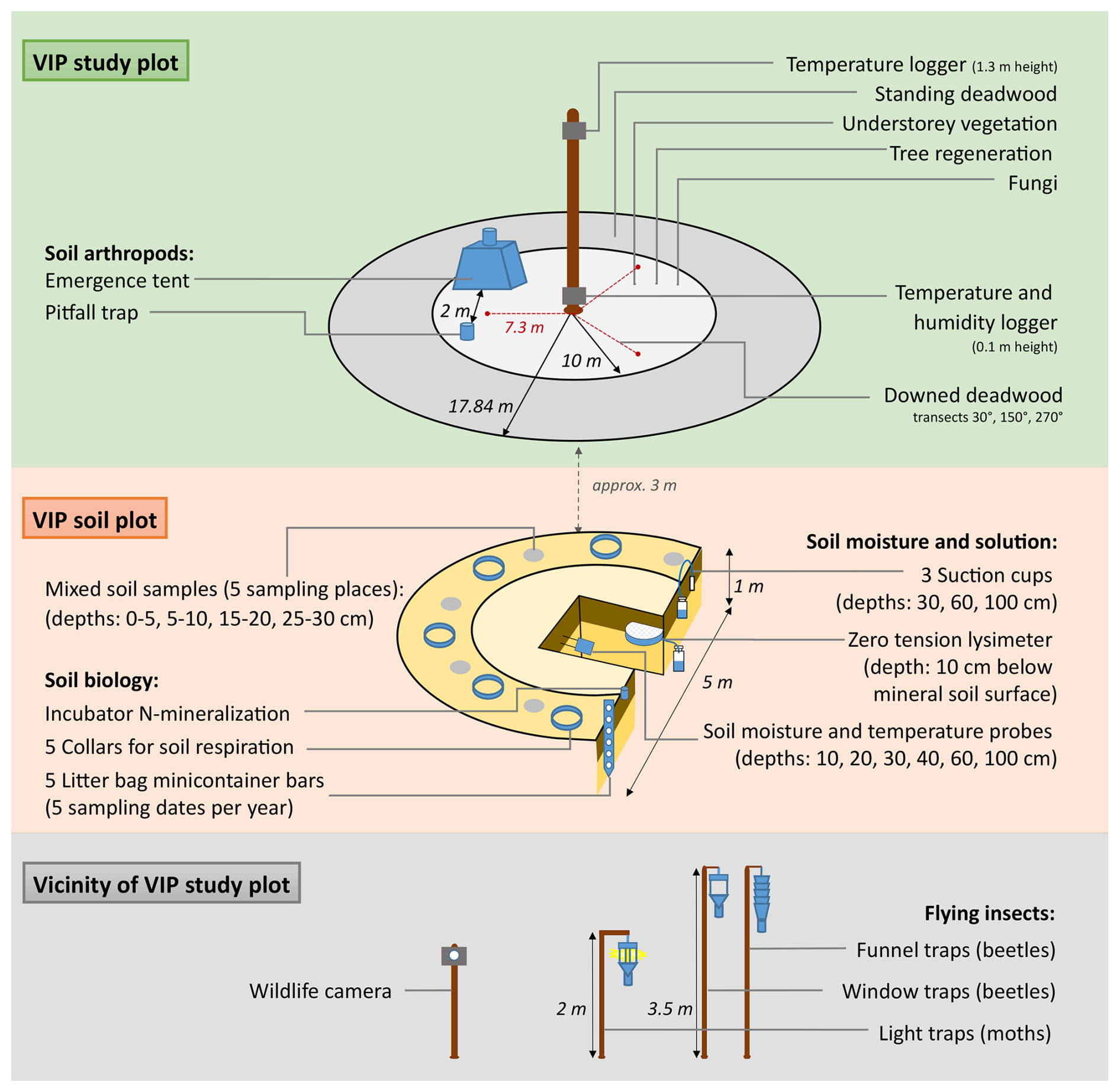
Figure 2Experimental setup and instrumentation on a VIP plot, a VIP soil plot, and measurements in the vicinity of the VIP plots. Reproduced with permission from Heinken et al. (2024).
At the center of each sample plot, a wooden pole with 1.5 meters height marked its exact location, which served as the reference point for data collection in the surrounding area.
Data collection included microclimatic measurements, mapping of stand structure, deadwood volumes and quality, tree regeneration, and understory vegetation across all plots. Fungi and predatory soil arthropods (e.g., ground beetles and spiders) were recorded on a subset of plots.
Soil investigations took place just outside the boundaries of the VIPs to minimize impact. For each site, on one VIP soil plot, a soil profile was temporarily opened to characterize soil type and enable the instrumentation for measuring soil moisture, soil, and seepage water.
In addition to these measurements associated with the plots, further data were acquired on the site level: saproxylic beetles and moths were trapped, mammals were monitored near VIPs, UAV flights and breeding bird surveys were conducted across the sites.
Rainfall measurements took place at three locations for each of the two research areas.
This section describes the relevant methods used in the acquisition of the data in this data publication. More details and a complete overview of all conducted measurements are contained in Heinken et al. (2024).
3.1 Overview and data formats
The overall data set is organized following the concept of Fersch et al. (2020) along the observed variables and instruments. Each subset of data is documented in a dedicated metadata file in “json” format to facilitate automated meta-data retrieval. The presented data largely consist of time series or intermittent observations that were obtained at well-defined locations. These locations are documented in a geospatial data set in the format of ESRI shapefiles further described in Sect. 3.2.
The observed time series are provided in tab-separated text files in which the first column contains the date and time (in UTC, ISO 8601 format). Any other columns represent measured or derived variables. Exceptions from this data model (e.g., vegetation, manual soil measurements) are described in the subsections of this paper and documented by json files with metadata. Table 2 demonstrates an overview of all data subsets, their temporal and spatial coverage and according subsections. Further details of the data repository are given in the data availability section.
3.2 Geodata
The exact locations of each plot with the additional soil and climate stations, and the boundary and extent of each site are stored in two ESRI shapefiles in (“plots” and “sites”, see Sect. 2.2) WGS 84 reference system. The center of each sample plot was measured with different methods and corresponding accuracy: The initial position had only been recorded via handheld GPS. In early 2023 after the second fire, all unaffected plots were re-surveyed with a RTK dGPS. The position of the burnt plots in sites C–F were reconstructed from the orthomosaics, as the area remained closed-off. The file states the survey method and acquisition date in the attribute table.
3.3 Climate
3.3.1 Weather station measurements
Two meteorological stations were established – one at TB inside site H and another near the former JB military training area. Each station consists of a mast, approximately 2 m in height, equipped with seven sensors that operate continuously. These sensors monitor leaf wetness, light intensity (including photosynthetically active radiation, PAR), barometric pressure, precipitation, solar radiation via a Silicon Pyranometer, temperature, relative humidity, and wind speed. The data was sampled at an interval of 10 s and stored locally every 10 min.
3.3.2 Precipitation
Additionally, in JB and TB, precipitation was measured at three locations within each study area or a maximum of 500 m from the nearest study site using a tipping bucket rain gauge (Davis, UK). Periods with missing or faulty rainfall data due to battery failure, theft, or clogged instruments were removed, and then a corrected average rainfall time series was calculated for each study area. Calibration measurements revealed an underestimation of rainfall by 15 %–25 %, so the measured rainfall was adjusted by +15 %. To validate the measurements, the nearest rainfall station from the DWD (Felgentreu Station) was used, which is located 2.6 and 7.2 km from the areas JB and TB, respectively. The dataset contains raw measurements and corrected average data.
Table 2Overview of Sect. 3: Summary of each data subset, main observed variables and units, temporal coverage and path in the data structure. All data with regular and fixed temporal resolution have been marked with table footnotes. Specific details can be found in the subsections and accompanying json-files in the repository (see also Table 3).
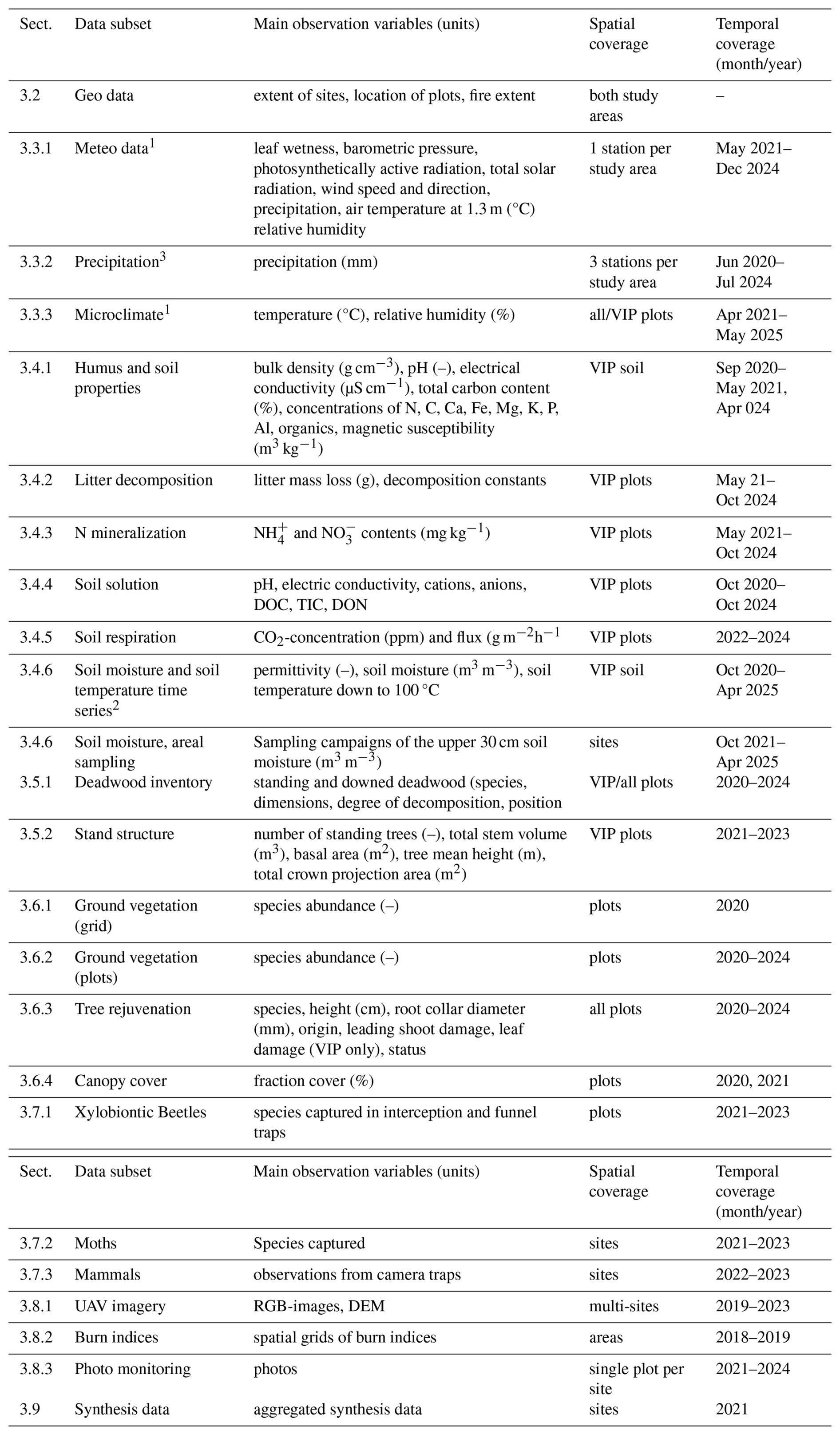
1 Fixed temporal resolution: 10 min., 2 Fixed temporal resolution: 20 min. 3 Fixed temporal resolution: 1 h.
3.3.3 Microclimate
At each study site, air temperature was recorded using HOBO Pendant temperature data loggers (Onset, USA), which were mounted at a height of 1.3 m in the center of each plot. To shield the sensors from direct solar radiation, the loggers were enclosed in white plastic radiation shields. In addition, temperature and relative humidity were measured using HOBO Pro V2 sensors (Onset, USA) installed 10 cm above the ground on the three VIPs at each site. These data were used to calculate vapor pressure deficit (VPD). VPD (kPa) was calculated as where es is the saturation vapor pressure (kPa), and ea is the actual vapor pressure (kPa). Saturation vapor pressure was estimated using the equation
and actual vapor pressure was calculated as
where T is the air temperature (°C) and RH is the relative humidity (%), both measured at 10 cm above ground. All loggers were synchronized to record data at 10 min intervals. Data were stored locally and manually retrieved every 4 to 8 weeks.
3.4 Soil
3.4.1 Humus and soil properties
For investigating soil conditions after fire and after post-fire treatments, soil samples were taken in each soil sampling plot. The initial sampling campaign took place between fall 2020 and spring 2021. The sampling campaign was repeated on most soil plots in spring 2024 to identify possible temporal changes. Around the center of the individual sampling plots, five points were defined for taking sub-samples from different depths. If there was a layer of litter and humus material, it was collected from an area of 30×30 cm at each subsampling point. Soil samples were taken at these points from the mineral soil at a depth of 0–5, 5–10, 15–20, and 25–30 cm. Subsamples from one sampling plot were combined to form mixed samples per depth and plot. The humus material was air dried (40 °C) and shred (cutting mill Pulverisette 25, Fritsch GmbH, Germany, with sieve 4 mm) and ground (Planetary ball mill PM-400, Retsch, Germany) for analysis. The mineral soil samples were air dried, sieved (<2 mm) and partly ground for analysis in the laboratory. For determining the bulk density of the mineral soil, soil cores of 4 cm height and a volume of 100 cm3 were used.
Organic carbon (OC) content of the litter and humus material was analyzed using an elemental analyzer (CNS Analyser Vario Max Cube, Elementar, Germany). OC stock of litter and humus layers was calculated. OC content of the mineral soil samples was analyzed using an elemental analyzer. OC stocks of the mineral topsoil could be calculated by means of bulk density values determined for the mineral topsoil. For bulk density (BD) determination, the volumetric soil samples were dried at 105 °C. The dry mass was weighed and related to the sample volume of 100 cm3.
Electric conductivity (EC) and pH were measured in water extracts with a ratio of 1:2.5 (soil : water) using a multiparameter meter (inoLab IDS, Multi 9420, WTW, Germany, with pH- and EC probes: SENTIX 980 and TetraCon 925, both WTW). For determining effective cation exchange capacity (CECeff) and base saturation (BS) the samples for the two depths were merged to samples for the depth of 0–10 cm. The extraction method with 1 mol L−1 NH4Cl solution developed by Lüer and Böhmer (2000) was applied, and the element concentrations (Na, K, Ca, Mg, Mn, Fe, Al) were measured by ICP-OES (iCAP 6000, Thermo Scientific, Life Technologies GmbH, Germany). Exchangeable H+ was calculated based on the pH difference in the NH4Cl solution during the extraction according to Bundesministerium für Verbraucherschutz (2009). The share of base cations (Na, K, Ca, Mg) in the total extracted quantity of cations was calculated as percentage base saturation (BS).
3.4.2 Litter decomposition
Litter decomposition as part of carbon cycling processes was investigated using the minicontainer method introduced by Eisenbeis et al. (1999). The minicontainers replace traditional litterbags and were filled with air dried and lightly crushed birch and pine litter (Fritsch cutting mill, with sieve 4 mm). About 200 mg of this litter was weighed in (fine scale Sartorius with 0.001 g display accuracy, Sartorius AG, Germany). The minicontainers were covered by gauze with a mesh size of 50 µm that allows mainly the soil microflora (bacteria and fungi) to access the litter material. From 2022 on, one additional container covered by a mesh with 100 µm was inserted at a depth of 2–4 cm. The minicontainer bars were vertically installed into the soil. The installation into the soil took place in spring of each year (2021–2024). Five minicontainer bars were used in parallel at each soil sampling plot of selected study sites. The individual bars were removed during the vegetation periods in 2021 until 2024 after 2, 4, 7, 16, and 25 weeks, respectively.
After removal of the minicontainer bars from the soil, the individual litter bags were air dried and the litter mass loss determined by weighing. Decomposition rates were calculated by regression analysis using the decay function
with mt: mass at time t; m0: mass at time t=0; k: decay constant.
3.4.3 Nitrogen mineralization
Net nitrogen mineralization was measured between 2021 and 2024 using the method described by Kwak et al. (2016). During the vegetation period (May to November), in situ soil core incubation was conducted for a duration of one month utilizing stainless steel tubes, each with a diameter of 4 cm and a length of 12 cm. The upper part of the tubes was covered by metal caps to prevent input from outside. Samples taken in the field were immediately stored in a cool place and kept deep-frozen until analysis.
The inorganic N (NH + NO) concentrations in the soil samples taken at the beginning of the respective incubation period (NH4_0/NO3_0) as well as the concentrations after the incubation period (NH4_Exp/NO3_Exp) were analyzed using FIA (see Sect. 3.4.4). The inorganic N content after the incubation was compared with the respective initial inorganic N content at the beginning of the incubation. The difference between the inorganic N content of the pre-incubation and the incubation samples was calculated as net N mineralization related to the duration of the incubation period (in days).
3.4.4 Soil solution
The effect of fire and post-fire management on the composition of the soil solution was investigated with free-draining lysimeters and suction cups to collect solution samples from different depths.
The small lysimeters were made from waste water pipes and filled with glass beads to optimize their mechanical stability. They were installed 10 cm deep below the surface of the mineral soil. During installation, disturbances of the upper layers were avoided. Lysimeters were centrally installed in the soil sampling plot and solution samples were collected whenever sufficient solution was available. In the first year (2021), samples were taken monthly; in the following years, the samples were typically collected every two months during the growing season. Electric conductivity was measured by a conductivity cell (WTW, Germany) and pH was measured potentiometrically (WTW, Germany). Elemental concentrations (Na, K, Ca, Mg, P) were determined using ICP-OES (Thermo Fisher) and inorganic N (NH and NO) with FIA (flow injection analysis, Medizin- und Labortechnik Engineering GmbH, Germany). Furthermore, dissolved organic carbon (DOC) was analyzed using a TOC-Analyzer (Shimadzu, Japan).
The suction cups (S12, Umwelt-Geräte-Technik GmbH (UGT), Germany) were installed on each Soil VIP plot, three vertically from the surface into depths of 30, 60 and 100 cm respectively. By applying a negative pressure of −0.5 bar using a mobile pump (MVF, UGT, Germany), the water from soil pores was sucked into the suction cups and then into separate glass bottles stored in a buried plastic box. The soil solution samples were collected typically every 2 months from November 2020 until November 2024 during the vegetation period if a sufficient volume (>10 mL) was available. Upon collection, the soil solution samples were filtered (MN619, G, 150 mm) within 24 h and afterwards stored frozen until analysis. The samples with low volume (<10 mL) were diluted and all results were corrected accordingly. Soil solution analysis involved the following devices: pH (–, WTW); conductivity (µS cm−1, Inlab 731 ISM, Mettler Toledo); ammonium, nitrate, phosphate concentration (mg L−1, Rundküvettentest Nanocolor, Macherey Nagel, Germany); absorbance at 350 nm (–, Nanocolor Vis 2 photometer, MN); Ca, Mg, Na, K concentration (mg L−1, ICP-OES iCAP 6000, Thermo Scientific, Life Technologies GmbH, Germany); DOC (mg mL−1), hydrophobics (%), biopolymers (%), humics + building blocks (perc.), low molecular weights (%), humics aromaticity (l mg−1 m−1), humics molecular weight (g mol−1) and humics (%) using a Liquid chromatography – organic carbon detection (LC-OCD) system model 8 (Dr. Huber, Germany) and the chromatograms obtained were interpreted using DOC-Labor ChromCALC software program.
3.4.5 Soil respiration
Soil Respiration (Rs) was measured throughout the vegetation period (from March to November) roughly every two weeks in the years 2022, 2023, and 2024. On each Soil VIP plot, five PVC collars (75 mm height × 100 mm diameter) were inserted permanently into the soil to ca. 5 cm depth (with ca. 2–3 cm of the collar protruding above the soil) in March 2022 (March 2023 for site L) as described in Heinken et al. (2024). The height of each collar protruding above soil was measured yearly. Rs was measured using a portable infrared gas analyser (EGM-5) with a SRC-2 soil respiration chamber (150 mm height × 100 mm diameter) (both from PP-systems). Additionally, soil temperature (Tsoil, °C) and soil moisture (Msoil, % VWC) at a depth of 5 cm were measured locally for each Rs measurement (HydraProbe, Stevens). The Rs measurements would end after either 140 s (DT) or a change in CO2 concentration of 100 ppm (DC). Rs was automatically calculated by the EGM-5 program (SRL, g CO2 m−2 h−1). The Rs values (SRL) at the end of each measurement were selected and compiled here.
3.4.6 Soil moisture and temperature
Soil moisture and temperature were monitored with one station at each study site, located at the soil VIP plots together with the soil chemical instruments. The measurements were recorded every 20 minutes at two replicate profiles with six different depths (10, 20, 30, 40, 60, 100 cm) using dielectric sensors (SMT-100, Truebner, Germany). In addition, two extra profiles were set up at sites F and H to compare the soil moisture dynamics between the top and furrow of the plough structures. At study site J in TB, three profile probes with nine measurement depths (SoilVUE, Campbell Scientific, UK) were installed to study intra-plot variability.
As the study areas exhibited a high degree of small-scale variability in soil moisture, measurement campaigns were conducted using portable Frequency Domain Reflectometry soil moisture sensors (ML2x, DeltaT, UK). These campaigns covered 18 points per study area, with depth-specific sampling carried out in 5 cm increments (0–35 cm). The repeated measurements on site I allowed the selection of the most suitable structure of a linear model (simple linear model with a fixed intercept of 0) for correcting the continuous station measurements to the spatial mean. Consequently, the regression coefficient could be estimated for each site. This analysis was performed separately for the measurement depths of 10, 20, and 30 cm.
3.5 Deadwood and stand inventory
3.5.1 Deadwood
In order to measure the deadwood volume and its temporal dynamics, different survey methods were used.
SDW: Standing deadwood. During the baseline survey, all trees and stumps of at least 7 cm in diameter were recorded in the radius of 17.8 m (A=1000 m2) around the centre of the three VIP plots of each site. With this baseline assessment, many detailed parameters (condition, position, diameter, height, bark) were documented. Afterwards, every six months, the condition was re-examined.
DDW: Downed deadwood. To record the volume and condition of the lying deadwood in all its dimensions, the line intersect sampling was used. This method is based on the USDA Forest Service forest inventory (Waddel, 2002; Woodall et al., 2019) but was adapted (Schirrmacher and Clerc, 2023) to the experimental design in the PYROPHOB project. The sampling was used on all plots (VIP and ITP) and covers all deadwood starting from a diameter of 0.1 cm: Three transects are laid out from the plot center in 30, 150, and 270° direction, each with a length of 7.3 m, and all intersections with deadwood are recorded.
3.5.2 Stand inventory data by terrestrial laserscanning
Based on annual measurement campaigns by terrestrial laserscanning (TLS), stand inventory parameters were estimated for all VIP plots. A circular area of 1000 m2 (radius = 17.84 m) was covered on each plot by a total of 9 individual scans with a FARO Focus S scan terrestrial laser scanner (FARO Technologies Inc., 2021). The data set presented here includes two to three annual scan campaigns (TB: 2021–2022; JB: 2021–2023). Independent of individual tree vitality (live or dead), changes in standing trees for the main species Pinus sylvestris are represented by the following variables: number of standing trees, total stem volume, basal area, tree mean height, total crown projection area. Registered and optimized point clouds on the plot level were automatically processed by script-controlled functions of the R packages TreeLS (de Conto, 2023) and lidaRtRee (Monnet, 2023) to detect and model single trees and estimate basic inventory data, stem volumes, and crown projections.
3.6 Vegetation
3.6.1 Ground vegetation data grid Treuenbrietzen 2020
This dataset provides additional vegetation data to the PYROPHOB plots for the Treuenbrietzen study area in the second year after the fire. Vegetation was surveyed between May and October 2020 on circular plots with a 10 m radius (A=314.16 m2) on a systematic grid of 100×100 m over almost the entire burned area. On each plot, the percentage cover of the bryophyte and the herb layer was visually estimated. All vascular herbaceous plant and bryophyte species were recorded and the cover of each species was estimated using a refined Londo scale (Zacharias, 1996). The nomenclature for vascular plants (except aggregate species) follows the Euro+Med PlantBase (Euro+Med, 2006) and the nomenclature for bryophytes follows the European checklist (Hodgetts and Lockhart, 2020). Species were assigned to regeneration strategies (invader, seed banker, sprouter, bryophyt). We assessed post-fire forest management, fire severity, pre-fire stand age and pre-fire forest continuity for each plot, and provide the exact spatial location of each plot. This dataset has been analysed in a separate manuscript to explore the effects of pre-fire land use legacies and post-fire forest management on vegetation and is currently under review.
3.6.2 Vegetation data of the PYROPHOB plots 2020–2024
Vegetation was recorded on all ten plots per site in each year (2020–2024) where possible. However, due to ammunition and the second fire in 2022, not all sites could be surveyed every year. Tree, herb, bryophyte and lichen species were surveyed on 10 m radius circular plots (area = 314.16 m2) between May and August on the burned sites and between July and October on the unburned control sites. The cover of all species was estimated using a refined Londo scale (Zacharias, 1996). Artificial tree regeneration, which was planted or sown after the fire, was excluded from the dataset. The nomenclature follows the Euro+Med PlantBase (Euro+Med, 2006) for vascular plants (except aggregate species), the European checklist of bryophytes (Hodgetts and Lockhart, 2020) and the German Red List for lichens (Wirth et al., 2011). The species were categorized according to a regeneration strategy, status (native, archaeophyte, or neophyte) and a growth type, based on information regarding clonal reproduction and lifespan (Klotz et al., 2002).
3.6.3 Tree rejuvenation
In order to record tree regeneration as a key indicator of the success of forestry treatments, the emergence of tree regeneration, as well as the growth of sown and planted trees, was systematically investigated. Two different methods were used for this.
Tree rejuvenation at VIPs: All trees up to a DBH (diameter breast height) of 7 cm within a radius of 10 m (A=314.16 m2) were documented once a year after the vegetation period in terms of height and root collar diameter. The type of regeneration was classified into “naturally established”, “planted” or “sown”. Tree status was differentiated into “alive”, “cut” (one of the plots served as a compensation area planted with sessile oaks, so natural regeneration was cut back to protect and promote the planted oak), “bent over” or “dead”. Damages of the leading shoot were classified in the categories “browsed”, “broken” or “else” (e.g., desiccated, fungi). Leaf damage was recorded when more than 30 % of the leaves showed significant damage.
Tree rejuvenation at ITPs: in order to be able to monitor individual tree growth as well, each tree was marked with an individual number within a radius of 2 m (A=12.57 m2). All trees taller than 10 cm in height and smaller than 7 cm in DBH were surveyed every winter. Except for leaf damage, the variables recorded are the same as for the VIP survey. Trees with a height < 10 cm were only identified and counted.
3.7 Fauna
3.7.1 Xylobiontic beetles
The surveys of the saproxylic beetle fauna were conducted between 2021 and 2023 at a total of 16 study sites, with 11 located in TB and 5 in JB. Sampling was carried out annually and continuously from mid-April to the end of August. In 2022, sampling on seven plots in TB had to be terminated early in June due to another wildfire event. In the following year (2023), only two of the originally seven fire-affected plots could be resampled. Saproxylic beetles were sampled using flight-interception traps. At each site, two different trap types were placed near two randomly selected VIP plots. First, window traps consisted of a crossed pair of transparent plastic shields (28×43 cm) connected to a funnel and a collection jar. These traps were mounted directly onto the trunks of standing dead pine trees at a height of approximately 3.5 m (measured to the upper edge). Second, Lindgren funnel traps (Lindgren, 1983, 11-unit funnel trap, 100×19 cm) were suspended on ropes between two dead pine trees at a comparable height of around 3.5 m. Additionally, a single canopy funnel trap was deployed in each region. In TB, canopy sampling was conducted only in 2021, as no suitable standing pine trees remained from 2022 onward. In contrast, canopy sampling in JB was performed throughout all three years of the study. Salt solution was used as the sampling fluid in the collection jars of both trap types. All captured saproxylic beetles were identified at the species level, with the exception of members of the family Staphylinidae (rove beetles).
3.7.2 Moths
The moth abundance was sampled between mid-March and early November (2021–2023) on the VIP plots dependent on weather conditions and lunar cycle (Heinken et al., 2024). All three VIP-plots were instrumented with an automated window cross light trap. Each site was sampled five to ten times per year, with reduced sampling for the TB sites after the second fire. To sample the moths, automated window cross light traps were used. The trap was powered by power banks with a duration of up to six hours per night after sunset. Afterwards, each individual was identified to species level after Steiner (2014) and measured in dry weight and wing index. Species were assigned to ecological and functional traits (such as habitat preferences, caterpillar food plant or distribution), as well as red list status (in: Rote Liste der gefährdeten Schmetterlinge Brandenburgs (Makrolepidoptera, Pyraloidea), Gelbrecht et al., 2001). The data included here only include the raw data with the species identification.
3.7.3 Mammals
As a wildfire is a disturbance in the vegetation structure, it is also a loss or change of the habitat situation of animals. To monitor the impact and reestablishment of mammals at each site, two locations were selected and identified as positions 1 and 2 to improve coverage in very heterogeneous sites. Subsequently, a camera trap was installed at position 1 for a duration of 15 d, following which it was relocated to position 2 for an additional 15 d. The locations are independent of plot positions, and available in a separate file. Surveys were conducted four times a year to study possible seasonal changes in mammal behaviour. Seasons were defined as winter from December to February, spring from March to May, summer from June to August, and autumn from September to November. The resulting approx. 140 000 digital images were processed visually for sightings of the targeted mammal species.
3.8 Remote sensing and ground-based imaging
3.8.1 UAV imagery
To gain a deeper understanding of spatial relationships, field-collected data on vegetation and forest structure were supplemented with remote sensing. For TB, unmanned aerial vehicles (UAV, i.e., Mavic Pro, DJI, China) were utilized to capture RGB imagery with sub-decimeter ground resolution. The image acquisition took place once a year at the end of spring from 2019 to 2023. The strip-wise flight patterns allowed for sufficient overlap (longitudinal: 75 %–90 %, transversal: 68 %–81 %) when flown at an altitude of 120 m. A workflow for image mosaicking was created following USGS guidelines (United States Geological Survey, 2017) and customized for the specific site requirements. As the orthomosaics were created with a focus on image quality, an improvement in the surface model creation may be recommendable for the investigation of structures on the sub-meter scale like ploughing ridges, shrubs, etc. Therefore, we share the raw images from each flight. The mosaicked orthophotos are available at https://deadtrees.earth/ (last access: 12 November 2025), an open-access platform that hosts a global database of high-resolution aerial imagery with labeled (i.e., manually classified) standing deadwood. This extensive dataset serves as a foundation for understanding tree mortality patterns worldwide.
3.8.2 Burn severity
The Burn severity was evaluated using the Difference Normalized Burn Ratio Index (dNBR; Key and Benson, 2005) for both study areas, utilizing multispectral satellite data (Sentinel-2 with 10–20 m spatial resolution; 19 August 2018 for TB, and 26 June 2019 for JB). This index was also used for the primary delineation of the study sites. Since this spatial scale offers limited information at the plot level, two additional indices were used, relying on bands with an increased resolution of 10 m. Using the NIR/green ratio (Daughtry et al., 2000) in JB and the MCARI1 (Haboudane et al., 2004) in TB allowed classifying the data into “burn class” categories, distinguishing between unburned, surface fire, and crown fire areas. The indices were chosen according to the best visual correspondence to the mentioned classes. The respective multispectral raw data can be acquired for free from the stated resources; here we only included the above mentioned derived indices as geospatial data. As ground truth data for the burn severity, the border of the burned area in TB was recorded in the field between autumn 2021 and spring 2022. This border was mostly clearly visible from the consumed humus and bryophyte layers as well as charred stems inside the burned area. The mapped area is provided as an ESRI-shapefile in the dataset.
3.8.3 Photo monitoring
Photo monitoring served for documenting the forest regrowth throughout the project period. For that purpose, photographs were taken at approximately three-month intervals using full-frame mirrorless cameras Z5, Z6, and D780 (Nikon, Japan) for one selected plot of each site. For scale, a survey rod with 50 cm-intervals is included in the photos.
Additionally, photos of the instrument setup are included in a separate folder.
Due to high resolution data, file size is around 20 MB for each image. Therefore we also provide thumbnails of the images, with file sizes of roughly 100 kB each.
3.9 Synthesis data set
To study the effects of post-fire forest management on several ecosystem components, data collected in 2021 (and late 2020 or early 2022) in the TB study area were analyzed together. We decided to use this reduced time span for the synthesis data set, as it allows the largest number of study sites to be included. For this purpose, the above-mentioned specific datasets needed to be converted to the same spatiotemporal resolution. This joint dataset comprises mineral topsoil properties (pH, nitrogen content, phosphorus, exchangeable magnesium, potassium, and calcium), volume of lying deadwood, herb layer cover and total biomass (above and below ground) of tree regeneration (natural and artificial), herb and bryophyte layer allometrically estimated with Schüle and Heinken (2024), species richness of vegetation (vascular plants and bryophytes) and saproxylic beetles. The continuously recorded variables air temperature, relative humidity, soil temperature, and soil moisture were used to produce aggregated indicators for specific purposes (heat stress, drought stress, maximum temperatures, vapour pressure deficit – VPD) and were aggregated over time to a single value for each plot. Where a variable was not assessed on all plots of a site (e.g., only on the VIPs), the mean values of the assessed plots of each site were used to replace missing values in other plots of the same site in the dataset.
The following subsections highlight relevant data sets that have been published already or are provided by other organizations or channels, but that we consider to be potentially helpful to users of the data presented in Sect. 3.
4.1 Landuse and DEM
The state agency of Brandenburg provides various geoinformation services, among them a high-resolution digital elevation model (DEM) with a 1 m horizontal resolution, accessible through the Geobasis Brandenburg service via the following WMS link: https://isk.geobasis-bb.de/mapproxy/dgm/service/wms (last access: 28 May 2025).
4.2 Land cover
Geobasis Brandenburg also offers orthophotos covering the entire state, captured over a three-year period starting in 2009. These orthophotos have a ground resolution of 20 cm per pixel and include both RGB and infrared (CIR) imagery. They are particularly useful in vegetation-related studies. Older orthophotos are also available and may enable long-term investigations, though they feature lower resolutions and limited spectral coverage.
4.3 Soil and geohydrological maps
The Geoportal Brandenburg at https://geoportal.brandenburg.de/de/cms/portal/geodaten/themenkarten (last access: 28 May 2025) provides interactive maps and WMS services on soil maps in various resolutions. Various geohydrological maps (e.g., groundwater catchments, depth to the groundwater table, etc.) and station observations can be accessed via the APW Brandenburg portal at https://apw.brandenburg.de/ (last access: 28 May 2025).
4.4 Meteo data
The closest meteostations of the German Weather Service DWD are Felgentreu (ID: 1350) and Treuenbrietzen (ID: 5092). Their data can be accessed via DWD's web portal https://opendata.dwd.de/climate_environment/CDC/observations_germany/climate/ (last access: 11 April 2025).
During the five years of monitoring, some of the resultant data have already been analysed. This section aims to give an overview of these studies, provide references, and discuss the potential for addressing pending questions.
In the following, we present the previously published studies based on the data presented in this paper.
5.1 Climate data
Blumroeder et al. (2022) assessed the effect of different forest management practices, using – among others – the microclimate data of the first monitoring years. They found a buffering effect of deadwood on the local temperature and water pressure deficit. It would be interesting to correlate the different deadwood dimensions (fine and coarse) with the climate data more detailed in order to be able to quantify the amount or type of deadwood at which such a buffering effect occurs. Exploiting the microclimate data to their full length would allow the quantification of these effects also for the later stages of forest regrowth. Many of the other studies listed below underline the importance of climatic conditions – locally due to management and temporarily due to climate and weather variability. Thus, further mutual analyses of biotic observations and climatic parameters seem promising.
5.2 Soil
Jouy et al. (2025) incorporated the soil data (i.e., nutrients and texture) in their analysis to assess recolonization by aspen trees, and attributed the observed high variability to a complex interaction of multiple further factors. Soil data in general are currently being evaluated. They show an almost complete loss of formerly thick humus layers and an increase in base saturation as the result of fire. Further, an alteration of soil conditions becomes visible as a result of post-fire management(complete salvage logging and ploughing). The data on leaching is under current analysis, regarding the relationship between DOC and the prior fire event and forest management. Likewise, the relationship between soil respiration and the intensity of the prior fire event could be of interest. Dobkowitz et al. (2025) used the data of soil moisture and temperature to assess drought and temperature stress for the different sites. Soil moisture time series served in the calibration of a soil hydraulic model, which also used the recorded meteo-data as an input variable. The model proved to perform unsatisfactorily, so a refined approach with a better representation of root water uptake and the specific soil hydraulic properties of the sandy soils could be envisioned.
5.3 Deadwood and stand structure
The large mounts in deadwood inventories and difficult access to some of the plots required the development of an efficient and robust methodology, which was documented by Clerc and Schirrmacher (2023). The concomitant data from both conventional and laserscanning-based methods (Clerc et al., 2023) allows for the systematic comparison of both approaches. Moreover, the added geometric detail of laserscanning-based data enables a deeper analysis of deadwood effects on microclimate, species diversity and abundance of insects. In conjunction with soil and seepage data, the role of deadwood decomposition on nutrient fluxes could be assessed. Likewise, an in-depth analysis of the protective effects of deadwood against damage through browsing or abundance of browsers could provide valuable insights on this relationship.
5.4 Vegetation
The collected vegetation data demonstrate the profound changes in vegetation composition following a fire. The data also show the rapid shifts in plant species composition in the first post-fire years, and the effects of post-fire forest management on vegetation. Schüle et al. (2023) and Blumroeder et al. (2022) conclude that natural regrowth resulting from limited interventions is strong, and emphasise the importance of potential seed trees and species that regenerate quickly, such as Populus, Betula and Robinia. Based on the vegetation surveys, Schüle and Heinken (2024) demonstrate the importance of pioneer species as they enhance quick biomass recovery, soil stabilization, and mitigation of mineral leaching. Jouy et al. (2025) emphasize the high variability of regeneration and the resulting future unpredictability due to the ongoing climate change and more regularly expected extreme weather events. However, a closer examination of regrowth dynamics in relation to the prevailing observed meteorological conditions is still pending.
Allometric models were developed to estimate the aboveground and belowground plant biomass in burned and unburned Scots pine forests (Schüle and Heinken, 2024). The above- and belowground biomass of various herb, grass and tree species, as well as aboveground biomass of several bryophyte species, was collected in 2021 across all study sites in Treuenbrietzen and Jüterbog. A detailed description of the sampling can be found in Schüle and Heinken (2024). The data of the collected biomass samples, which were used to build the allometric models, were published as online supplementary material of Schüle and Heinken (2024). They can be further used to assess post-fire carbon pools. Additional open scientific questions remain concerning the effects of land use legacy, fire severity, and spatial factors on post-fire vegetation.
5.5 Remote sensing and ground-based imaging
The acquired UAV-imagery helped in the development of an automated identification of standing deadwood (Schmehl, 2025). They were included in an intercomparison project for developing detection methods for tree mortality (Mosig et al., 2024). In a MSc thesis, the potential of multispectral satellite imagery for identifying habitat types could be shown. In conjunction with the detailed vegetation surveys, the UAV-data offer a rich test field for future tests on their usability for advanced image classification methods.
The repeated photo-shots of selected plots have served as an effective way to illustrate the observed regrowth, especially to the non-scientific public. Thanks to their high resolution, they may also hold the potential for the estimation of unmeasured parameters (e.g., combustible litter inventory) over time.
5.6 Synthesis
For an integrative assessment of the data, several analyses have been undertaken on the synthesis data (see Sect. 3.9), employing multivariate techniques such as PCA and mixed effects models. So far, the published studies focus mainly on ecological questions that compare different types of management and investigate how biotic and abiotic factors such as soil properties, fire severity, browsing, or potential seed trees influence the ecological outcome. Until now, only two of them (i.e., Schüle et al., 2023; Jouy et al., 2025) include impacts by fauna, but focus on the relation between abiotic, vegetation, and vegetation structure factors.
Due to the lack of replication in several treatments and data gaps caused by technical issues and the second fire in TB, a comprehensive comparison of all factors across all plots and the entire time period is not fully possible. However, the data present numerous opportunities for conducting more localized analyses (as mentioned in the previous subsections), like examining temporal changes at specific sites, which may not always include all datasets or plots.
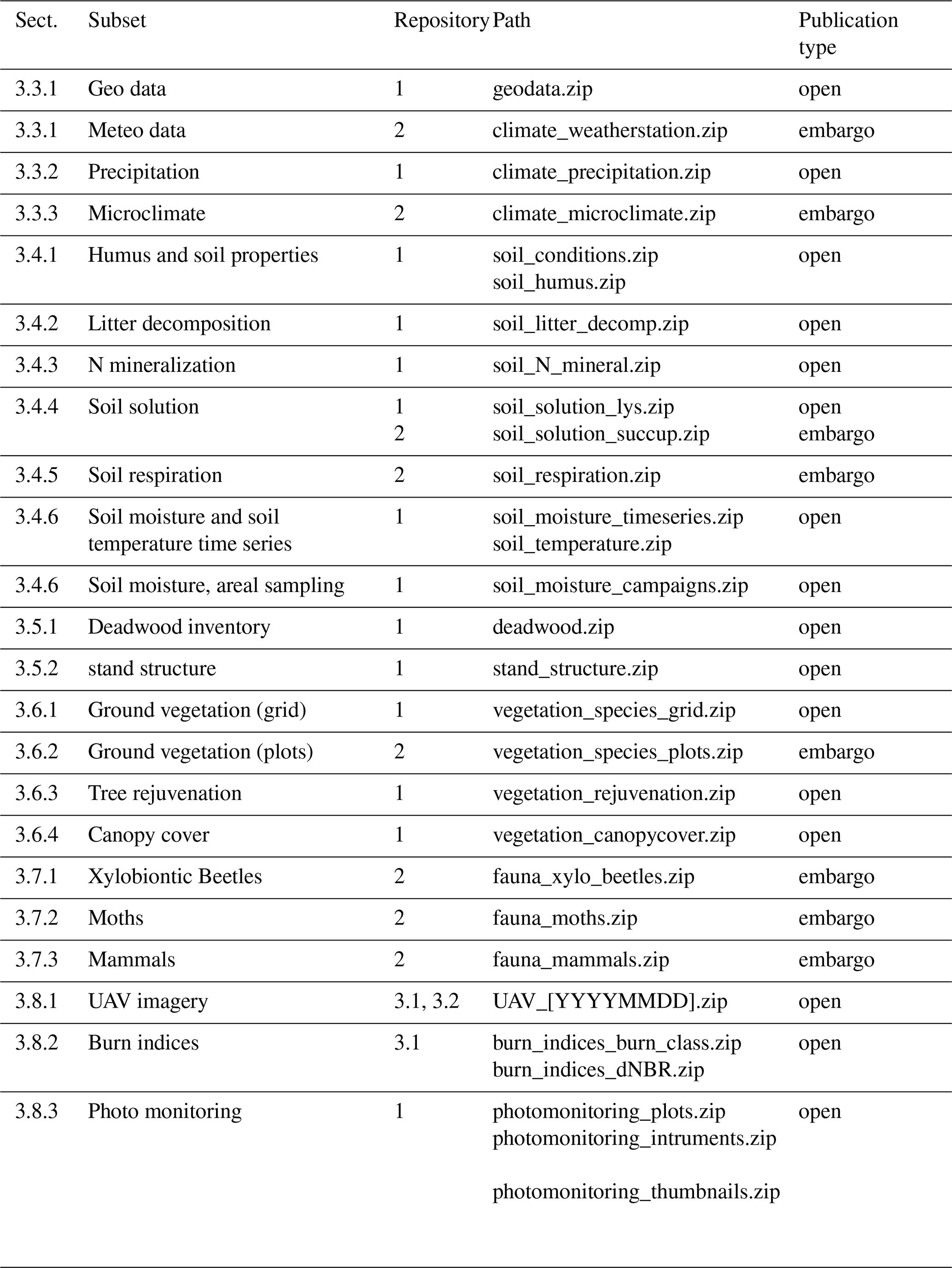
The published data set is organized along instruments and observed variables, and follows the structure of Sect. 3 of this paper (Table 3). Each subset of data is documented in a dedicated meta-data file in “json” format. Format conventions follow Fersch et al. (2020) and Heistermann et al. (2022) and are summarized in the file “readme.txt” at the top level. We used EUDAT infrastructure (https://eudat.eu, last access: 16 October 2025), namely the services B2SHARE and B2HANDLE, in order to manage identifiers and guarantee long-term persistence.
The described data are distributed over three repositories:
-
Main repository (https://doi.org/10.23728/b2share.08a, Schmehl et al., 2025a): this repository contains the main part of the described data
-
Embargoed repository (https://doi.org/10.23728/ b2share.515d0a8145a64db8, Schmehl et al., 2025b): as some of the described dataset are currently under analysis in ongoing studies, their contributors requested them to become available only after 31 March 2026. Access opens automatically after this date. The embargo concerns some of data on the meteo-observations, soil respiration, the fauna and additional years to the vegetation surveys.
-
Imagery data (https://doi.org/10.23728/b2share.de1661, Schmehl et al., 2025c and https://doi.org/10.23728/ b2share.51bdf4b6dc854873b6 Schmehl et al., 2025d): as the remote sensing imagery is especially extensive, we used two separate repositories to allow for a more granular data access that allows specifically downloading parts of interest instead of excessively large chunks.
Table 3 summarizes the allocation of each data subset to the repositories and its embargo state.
Besides the actual data, each folder contains a JSON file (readable ASCII text) holding metadata and additional format descriptions, where these differ from the conventions described in Sect. 3.1.
Table 3Organisation of the data subsets in the data repositories. See also Table 2 for corresponding details on the data subsets. Repository keys: (1) Schmehl et al. (2025a), (2) Schmehl et al. (2025b); (3.1) Schmehl et al. (2025c); (3.2) Schmehl et al. (2025d).
The PYROPHOB research project investigates the impacts of post-fire management strategies on forest recovery in Scots pine stands in Brandenburg, Germany. Its findings show that both pre-existing site conditions – such as soil texture, vegetation structure, and landscape context – and post-fire silvicultural treatments jointly determine forest regeneration outcomes. Unmanaged sites often exhibited more favorable microclimatic conditions and, partially, higher regeneration of pioneer species like Populus tremula, particularly where surrounding seed sources were available and soils retained some fertility.
The project highlights the need to consider the interplay between site-specific ecological conditions, historical land use legacies, and management intensity when planning forest restoration. In particular, natural succession involving fast-regenerating pioneer species contributed significantly to biomass recovery and microclimatic buffering, even under challenging post-fire conditions. These insights underscore the importance of context-sensitive, adaptive strategies for increasing forest resilience in the face of climate change.
This data paper describes the majority of the data acquired during the project and archives them to enable future re-use and reproducibility. The value of the data set lies in its role as an interdisciplinary effort carried out soon after the wildfire, offering a 5-year snapshot for assessing forest regrowth. Evidently, especially for forest ecosystems, long-term or repeated studies and monitoring would be advantageous, especially under transient climatic conditions. In that context, the occurrence of the second wildfire presents both severe constraints but also extra opportunities in the data.
Despite its limitations, this data set lays the groundwork for such extensive analyses. For similar future studies we recommend a well-planned study design, balancing the requirements and restrictions of the different disciplines while maximizing coherence in terms of spatiotemporal overlap in scale and representativity. Likewise, a platform for a low-threshold data interchange, including well-defined internal conventions, greatly fosters interdisciplinary data use. These prerequisites ensure that hypotheses can be tested rigorously on the appropriate spatial and temporal entities with maximum synergies between the different disciplines.
MTS and TF drafted the manuscript, coordinated the related data management and homogenization and led the writing of the manuscript; PI designed the layout of the study sites together with other members of the consortium and coordinated the project. The various co-authors acquired, processed and contributed the following datasets: YA and MSü with the help of all participating authors (synthesis data), AB, DC, PLI, LR, MSi and JS (tree rejuvenation and deadwood), CB (moths), SD and TF (soil moisture, precipitation), WG, TR and FR (soil), HH (beetles), TH and MSü (vegetation data), CH and JS (stand structure), KG, FJ and AVH (soil respiration and solution), LL (mammals), FR (soil solution), SR and PLI (meteo and microclimate). All authors contributed to writing and proofreading the manuscript.
The contact author has declared that none of the authors has any competing interests.
Publisher's note: Copernicus Publications remains neutral with regard to jurisdictional claims made in the text, published maps, institutional affiliations, or any other geographical representation in this paper. While Copernicus Publications makes every effort to include appropriate place names, the final responsibility lies with the authors. Views expressed in the text are those of the authors and do not necessarily reflect the views of the publisher.
The PYROPHOB project was funded by various institutions (see Financial support). The project's initiation was only made possible by the invitation of the municipal forester Dietrich Henke. Jeanette Blumröder played a vital role during the planning, application, and implementation of the project, and the deployment of the microclimatic instrumentation. We express our gratitude to Tilo Geisel of https://www.naturfoto-geisel.com/ (last access: 24 May 2025) for conducting the photo monitoring. We also thank our field technician Silvio Vogt (BTU) as well as numerous BSc and MSc candidates and student assistants for their contributions. We are indebted to the landowners (especially the town of Treuenbrietzen, the Waldgenossenschaft Bardenitz eG, and the Stiftung Naturlandschaften Brandenburg), the responsible foresters, and the authorities for their support. We thank the responsible state environmental offices of Brandenburg for the field permit (according to §67 BNatSchG) and the special permit for the capture of animals (according to §45 BNatSchG). We are grateful to EUDAT for providing a powerful infrastructure for data storage and handling.
AI tools were used for style and spell checking during the writing of the manuscript.
The PYROPHOB project was funded by the Forest Climate Fund (Waldklimafonds) via the Fachagentur Nachwachsende Rohstoffe e.V. (FNR) by the Federal Ministry of Food and Agriculture (Bundesministerium für Ernährung und Landwirtschaft, BMEL) and the Federal Ministry for the Environment, Nature Conservation and Nuclear Safety (Bundesministerium für Umwelt, Naturschutz und nukleare Sicherheit, BMU) (grants nos:. 2219WK50A4; 2219WK50B4; 2219WK50C4; 2219WK50D4; 2219WK50E4; 2219WK50F4; 2219WK50G4; 2219WK50H4).
This paper was edited by Jia Yang and reviewed by two anonymous referees.
Ayres, M. P., Hicke, J. A., Kerns, B. K., McKenzie, D., Littell, J. S., Band, L. E., Luce, C. H., Weed, A. S., and Raymond, C. L.: Disturbance Regimes and Stressors, in: Climate Change and United States Forests, vol. 57, series Title: Advances in Global Change Research, edited by: Peterson, D. L., Vose, J. M., and Patel-Weynand, T., Springer Netherlands, Dordrecht, 55–92, ISBN 978-94-007-7514-5, https://doi.org/10.1007/978-94-007-7515-2_4, 2014. a
Blumroeder, J. S., Schmidt, F., Gordon, A., Grosse, S., and Ibisch, P. L.: Ecosystemic resilience of a temperate post-fire forest under extreme weather conditions, Front. Forests Global Change, 5, https://doi.org/10.3389/ffgc.2022.1070958, 2022. a, b
Bundesministerium für Verbraucherschutz, Deutschland: Handbuch forstliche Analytik eine Loseblatt-Sammlung der Analysemethoden im Forstbereich, https://www.nw-fva.de/fileadmin/nwfva/publikationen/pdf/konig_handbuch_forstliche.pdf (last access: 16 April 2025), 2009. a
Clerc, D. and Schirrmacher, M.: Liegendes Totholz auf Schadflächen erfassen, AFZ-DerWald, 16–19, https://www.digitalmagazin.de/marken/afz-derwald/hauptheft/2023-11/waldinventuren/016_liegendes-totholz-auf-schadflaechen-erfassen (last access: 16 April 2025), 2023. a
Clerc, D., Schirrmacher, M., and Schroeder, J.: Waldbrand und wie weiter? Totholzdynamik auf den Brandflächen bei Treuenbrietzen aus Sicht des Projekts PYROPHOB, vol. 73, MLEUV – Ministerium für Land- und Ernährungswirtschaft, Umwelt und Verbraucherschutz, Brandenburg, https://www.researchgate.net/publication/371947326_Waldbrand_und_wie_weiter_Totholzdynamik_auf_den_Brandflachen_bei_Treuenbrietzen_aus_Sicht_des_Projekts_PYROPHOB (last access: 16 April 2025), 2023. a
Daughtry, C., Walthall, C., Kim, M., de Colstoun, E., Brown, and McMurtrey III, J.: Estimating corn leaf chlorophyll concentration from leaf and canopy reflectance, Remote Sens. Environ., 74, 229–239, https://doi.org/10.1016/s0034-4257(00)00113-9, 2000. a
de Conto, T.: TreeLS: Terrestrial Point Cloud Processing of Forest Data, r package version 2.0.5, GitHub [code], https://github.com/tiagodc/TreeLS (last access: 23 March 2025), 2023. a
Dobkowitz, S., Francke, T., and Schmehl, M.-T.: 6.3.3. Bodenhydrologi, in: PYROPHOB – Strategien zur Entwicklung von widerstandsfähigen Wäldern auf Waldbrandflächen, in: vol. 77 of Eberswalder Forstliche Schriftenreihe, MLEUV – Ministerium für Land- und Ernährungswirtschaft, Umwelt und Verbraucherschutz, Brandenburg, Potsdam, https://forst.brandenburg.de/sixcms/media.php/9/efs77.pdf (last access: 23 May 2025), 2025. a
Eisenbeis, G., Lenz, R., and Heiber, T.: Organic residue decomposition: The minicontainer-system a multifunctional tool in decomposition studies, Environ. Sci. Pollut. Res., 6, 220–224, https://doi.org/10.1007/BF02987332, 1999. a
Euro+Med: Euro+Med PlantBase – the information resource for Euro-Mediterranean plant diversity, http://www.europlusmed.org (last access: 24 February 2024), 2006. a, b
FARO Technologies Inc.: FARO Focus 3D Laser Scanner, Technische Spezifikationen, version 13.12.2021, https://www.faro.com (last access: 30 April 2025), 2021. a
Fersch, B., Francke, T., Heistermann, M., Schrön, M., Döpper, V., Jakobi, J., Baroni, G., Blume, T., Bogena, H., Budach, C., Gränzig, T., Förster, M., Güntner, A., Hendricks Franssen, H.-J., Kasner, M., Köhli, M., Kleinschmit, B., Kunstmann, H., Patil, A., Rasche, D., Scheiffele, L., Schmidt, U., Szulc-Seyfried, S., Weimar, J., Zacharias, S., Zreda, M., Heber, B., Kiese, R., Mares, V., Mollenhauer, H., Völksch, I., and Oswald, S.: A dense network of cosmic-ray neutron sensors for soil moisture observation in a highly instrumented pre-Alpine headwater catchment in Germany, Earth Syst. Sci. Data, 12, 2289–2309, https://doi.org/10.5194/essd-12-2289-2020, 2020. a, b
Gelbrecht, J., Weidlich, M., Clemens, F., Eichstädt, D., Rämisch, F., Ratering, S., and Richert, A.: Gesamtartenliste und Rote Liste der gefährdeten Schmetterlinge Brandenburgs (Makrolepidoptera, Pyraloidea), Naturschutz und Landschaftspflege in Brandenburg, Beilage zu Heft 3, https://lfu.brandenburg.de/sixcms/media.php/9/Heft+N&L_beil_3_2001_Gesamtartenliste.pdf (last access: 7 May 2025), 2001 a
Gustafsson, L., Granath, G., Nohrstedt, H.-O., Leverkus, A. B., and Johansson, V.: Burn severity and soil chemistry are weak drivers of early vegetation succession following a boreal mega-fire in a production forest landscape, J. Veg. Sci., 32, e12966, https://doi.org/10.1111/jvs.12966, 2021. a
Haboudane, D., Miller, J., Pattey, E., Zarco-Tejada, P., and Strachan, I.: Hyperspectral vegetation indices and novel algorithms for predicting green LAI of crop canopies: Modeling and validation in the context of precision agriculture, Remote Sens. Environ., 90, 337–352, https://doi.org/10.1016/j.rse.2003.12.013, 2004. a
Heinken, T., Blumröder, J. S., Adhikari, Y., Balthasar, C., Binder, A., Birkhofer, K., Bischoff, A., Brosinsky, A., Bubner, B., Clerc, D., Djoudi, E. A., Dobkowitz, S., Francke, T., Gerwin, W., Hartong, H., Hess, C., Jarling, R., Jouy, F., Leinen, L., Meißner, A., Raab, T., Repmann, F., Rönnefarth, S., Schaaf, W., Schirrmacher, M., Schmehl, M.-T., Schmitt, T., Schröder, J., Schüle, M., Sturm, K., Welle, T., and Ibisch, P. L.: PYROPHOB – A post-fire ecosystem research project to inform management for resilient forest development/PYROPHOB – Ein Ökosystemforschungsprojekt auf Waldbrandflächen als Grundlage für das Management einer resilienten Waldentwicklung, Tuexenia, 44, https://doi.org/10.14471/2024.44.004, 2024. a, b, c, d, e, f, g
Heistermann, M., Bogena, H., Francke, T., Gn̈tner, A., Jakobi, J., Rasche, D., Schrön, M., Döpper, V., Fersch, B., Groh, J., Patil, A., Pütz, T., Reich, M., Zacharias, S., Zengerle, C., and Oswald, S.: Soil moisture observation in a forested headwater catchment: combining a dense cosmic-ray neutron sensor network with roving and hydrogravimetry at the TERENO site Wüstebach, Earth Syst. Sci. Data, 14, 2501–2519, https://doi.org/10.5194/essd-14-2501-2022, 2022. a
Hodgetts, N. and Lockhart, N.: Checklist and country status of European bryophytes – update 2020, Irish Wildlife Manuals 123, National Parks and Wildlife Service, Department of Culture, Heritage and the Gaeltacht, Ireland, https://www.npws.ie/sites/default/files/publications/pdf/IWM123.pdf (last access: 23 March 2025), 2020. a, b
Jackisch, R., Putzenlechner, B., and Dietze, E.: UAV data of post fire dynamics, Quesenbank, Harz, 2022 (orthomosaics, topography, point clouds), Zenodo [data set], https://doi.org/10.5281/ZENODO.7554597, 2023. a
Jouy, F., Schüle, M., Adhikari, Y., Binder, A., Clerc, D., Gerwin, W., Heinken, T., Raab, T., Repmann, F., Rönnefarth, S., Schirrmacher, M., Schmehl, M.-T., Schröder, J., and Ibisch, P. L.: Factors impacting the variability of post-fire forest regeneration in central European pine plantations, Restor. Ecol., e70017, https://doi.org/10.1111/rec.70017, 2025. a, b, c
Key, C. and Benson, N.: Landscape Assessment: Remote sensing of severity, the Normalized Burn Ratio; and ground measure of severity, the Composite Burn Index, RMRS-GTR-164-CD; LA-1-55, USDA Forest Service, Rocky Mountain Research Station, Ogden, https://www.frames.gov/documents/projects/firemon/FIREMON_LandscapeAssessment.pdf (last access: 5 July 2023), 2005. a
Klose, S. and Makeschin, F.: Soil properties in coniferous forest stands along a fly ash deposition gradient in eastern Germany, Pedosphere, 15, 681–694, 2005. a
Klotz, S., Kühn, I., Durka, W., and Briemle, G.: BIOLFLOR: Eine Datenbank mit biologisch-ökologischen Merkmalen zur Flora von Deutschland, Bundesamt für Naturschutz, Bonn, Germany, ISBN 9783784335087, 2002. a
Kwak, J., Chang, S., Naeth, M., and Schaaf, W.: Nitrogen transformation rates are affected by cover soil type but not coarse woody debris application in reclaimed oil sands soils, Restor. Ecol., 24, 506–516, https://doi.org/10.1111/rec.12344, 2016. a
Lemmon, P. E.: A Spherical Densiometer For Estimating Forest Overstory Density, Forest Sci., 2, 314–320, https://doi.org/10.1093/forestscience/2.4.314, 1956. a
Li, X., Jin, H., Feng, Q., Wu, Q., Wang, H., He, R., Luo, D., Chang, X., Şerban, R.-D., and Zhan, T.: An integrated dataset of ground hydrothermal regimes and soil nutrients monitored in some previously burned areas in hemiboreal forests in Northeast China during 2016–2022, Earth Syst. Sci. Data, 16, 5009–5026, https://doi.org/10.5194/essd-16-5009-2024, 2024. a
Lindgren, B. S.: A Multiple Funnel Trap for Scolytid Beetles (Coleoptera), Can. Entomolog., 115, 299–302, 1983. a
Lüer, B. and Böhmer, A.: Vergleich zwischen Perkolation und Extraktion mit 1 M NH4 Cl‐Lösung zur Bestimmung der effektiven Kationenaustauschkapazität (KAKeff) von Böden, Z. Pflanzenernähr. Bodenk., 163, 555–557, https://doi.org/10.1002/1522-2624(200010)163:5<555::AID-JPLN555>3.0.CO;2-#, 2000. a
Michel, A. K.: Forest Condition in Europe: The 2022 Assessment; ICP Forests Technical Report under the UNECE Convention on Long-range Transboundary Air Pollution (Air Convention), Johann Heinrich von Thünen-Institut, Germany, ISBN 978-3-86576-240-5, https://doi.org/10.3220/ICPTR1656330928000, 2022. a
Monnet, J.-M.: lidaRtRee: Forest Analysis with Airborne Laser Scanning (LiDAR) Data, r package version 4.0.5, CRAN, https://CRAN.R-project.org/package=lidaRtRee (last access: 23 March 2025), 2023. a
Mosig, C., Vajna-Jehle, J., Mahecha, M. D., Cheng, Y., Hartmann, H., Montero, D., Junttila, S., Horion, S., Schwenke, M. B., Adu-Bredu, S., Al-Halbouni, D., Allen, M., Altman, J., Angiolini, C., Astrup, R., Barrasso, C., Bartholomeus, H., Brede, B., Buras, A., Carrieri, E., Chirici, G., Cloutier, M., Cushman, K., Dalling, J. W., Dempewolf, J., Denter, M., Ecke, S., Eichel, J., Eltner, A., Fabi, M., Fassnacht, F., Feirreira, M. P., Frey, J., Frick, A., Ganz, S., Garbarino, M., García, M., Gassilloud, M., Ghasemi, M., Giannetti, F., Gonzalez, R., Gosper, C., Greinwald, K., Grieve, S., Gutierrez, J. A., Göritz, A., Hajek, P., Hedding, D., Hempel, J., Hernández, M., Heurich, M., Honkavaara, E., Jucker, T., Kalwij, J. M., Khatri-Chhetri, P., Klemmt, H.-J., Koivumäki, N., Korznikov, K., Kruse, S., Krüger, R., Laliberté, E., Langan, L., Latifi, H., Lehmann, J., Li, L., Lines, E., Lopatin, J., Lucieer, A., Ludwig, M., Ludwig, A., Lyytikäinen-Saarenmaa, P., Ma, Q., Marino, G., Maroschek, M., Meloni, F., Menzel, A., Meyer, H., Miraki, M., Moreno-Fernández, D., Muller-Landau, H. C., Mälicke, M., Möhring, J., Müllerova, J., Neumeier, P., Näsi, R., Oppgenoorth, L., Palmer, M., Paul, T., Potts, A., Prober, S., Puliti, S., Pérez-Priego, O., Reudenbach, C., Rossi, C., Ruehr, N. K., Ruiz-Benito, P., Runge, C. M., Scherer-Lorenzen, M., Schiefer, F., Schladebach, J., Schmehl, M.-T., Schwarz, S., Seidl, R., Shafeian, E., de Simone, L., Sohrabi, H., Sotomayor, L., Sparrow, B., Steer, B. S., Stenson, M., Stöckigt, B., Su, Y., Suomalainen, J., Torresani, M., Umlauft, J., Vargas-Ramírez, N., Volpi, M., Vásquez, V., Weinstein, B., Ximena, T. C., Zdunic, K., Zielewska-Büttner, K., de Oliveira, R. A., van Wagtendonk, L., von Dosky, V., and Kattenborn, T.: deadtrees.earth – An Open-Access and Interactive Database for Centimeter-Scale Aerial Imagery to Uncover Global Tree Mortality Dynamics, bioRxiv [preprint], https://doi.org/10.1101/2024.10.18.619094, 2024. a
Naethe, K., Levia, D. F., Tischer, A., and Michalzik, B.: Low-intensity surface fire effects on carbon and nitrogen cycling in soil and soil solution of a Scots pine forest in central Germany, Catena, 162, 360–375, https://doi.org/10.1016/j.catena.2017.10.026, 2018. a
Schauermann, J.: Development Of Insect Populations On Burned Pine Plantation Areas In The Northwest German Lowland, Entomolog. General., 6, 193–199, 1980. a
Schirrmacher, M. and Clerc, D.: Liegendes Totholz auf Schadflächen erfassen, AFZ – Der Wald, https://www.waldwissen.net/assets/technik/inventur/lfe_Inventur_liegendes_Totholz/Engel_Schirrmacher_Clerc_liegendes_totholz_ste.pdf (last access: 15 May 2025), 2023. a
Schmehl, M.-T.: 6.4.4. Vegetationsstrukturen, in: PYROPHOB – Strategien zur Entwicklung von widerstandsfähigen Wäldern auf Waldbrandflächen, in: vol. 77 of Eberswalder Forstliche Schriftenreihe, MLEUV – Ministerium für Land- und Ernährungswirtschaft, Umwelt und Verbraucherschutz, Brandenburg, Potsdam, https://forst.brandenburg.de/sixcms/media.php/9/efs77.pdf (last access: 23 May 2025), 2025. a
Schmehl, M.-T., Adhikari, Y., Balthasar, C., Binder, A., Clerc, D., Dobkowitz, S., Gerwin, W., Günther, K., Hartong, H., Heinken, T., Hess, C., Ibisch, P. L., Jouy, F., Leinen, L., Raab, T., Repmann, F., Rönnefarth, S., Rohlfs, L., Schirrmacher, M., Schröder, J., Schüle, M., Vieth-Hillebrand, A., and Francke, T.: Forest regrowth after wildfire in northeastern Germany – data from the PYROPHOB project – Part 1, B2SHARE [data set], https://doi.org/10.23728/b2share.08a6a8b56f774a08a984871e7e, 2025a. a, b, c
Schmehl, M.-T., Adhikari, Y., Balthasar, C., Binder, A., Clerc, D., Dobkowitz, S., Gerwin, W., Günther, K., Hartong, H., Heinken, T., Hess, C., Ibisch, P. L., Jouy, F., Leinen, L., Raab, T., Repmann, F., Rönnefarth, S., Rohlfs, L., Schirrmacher, M., Schröder, J., Schüle, M., Vieth-Hillebrand, A., and Francke, T.: Forest regrowth after wildfire in northeastern Germany – data from the PYROPHOB project – Part 2 (access after 31. Mar. 2026), B2SHARE [data set], https://doi.org/10.23728/b2share.515d0a8145a64db8b3069466d, 2025b. a, b, c
Schmehl, M.-T., Adhikari, Y., Balthasar, C., Binder, A., Clerc, D., Dobkowitz, S., Gerwin, W., Günther, K., Hartong, H., Heinken, T., Hess, C., Ibisch, P. L., Jouy, F., Leinen, L., Raab, T., Repmann, F., Rönnefarth, S., Rohlfs, L., Schirrmacher, M., Schröder, J., Schüle, M., Vieth-Hillebrand, A., and Francke, T.: Forest regrowth after wildfire in northeastern Germany – data from the PYROPHOB project – Part 3.1 (Remote Sensing Data), B2SHARE [data set], https://doi.org/10.23728/b2share.de1661761da5481f938caf460e, 2025c. a, b, c
Schmehl, M.-T., Adhikari, Y., Balthasar, C., Binder, A., Clerc, D., Dobkowitz, S., Gerwin, W., Günther, K., Hartong, H., Heinken, T., Hess, C., Ibisch, P. L., Jouy, F., Leinen, L., Raab, T., Repmann, F., Rönnefarth, S., Rohlfs, L., Schirrmacher, M., Schröder, J., Schüle, M., Vieth-Hillebrand, A., and Francke, T.: Forest regrowth after wildfire in northeastern Germany – data from the PYROPHOB project – Part 3.2 (Remote Sensing Data), B2SHARE [data set], https://doi.org/10.23728/b2share.51bdf4b6dc854873b6ff44fddd, 2025d. a, b, c
Schüle, M. and Heinken, T.: Allometric estimation models for aboveground and belowground biomass of pre-fire and post-fire vegetation in Scots pine forests, Forestry, https://doi.org/10.1093/forestry/cpae026, 2024. a, b, c, d, e
Schüle, M., Domes, G., Schwanitz, C., and Heinken, T.: Early natural tree regeneration after wildfire in a Central European Scots pine forest: Forest management, fire severity and distance matters, Forest Ecol. Manage., 539, 120999, https://doi.org/10.1016/j.foreco.2023.120999, 2023. a, b
Steiner, A.: Die Nachtfalter Deutschlands: ein Feldführer: sämtliche nachtaktiven Großschmetterlinge in Lebendfotos und auf Farbtafeln, Bugbook Publishing, Østermarie, ISBN 9783000438622, 2014. a
Stevens-Rumann, C. S., Kemp, K. B., Higuera, P. E., Harvey, B. J., Rother, M. T., Donato, D. C., Morgan, P., and Veblen, T. T.: Evidence for declining forest resilience to wildfires under climate change, Ecol. Lett., 21, 243–252, https://doi.org/10.1111/ele.12889, 2018. a
Tesha, D. L., Madundo, S. D., and Mauya, E. W.: Post-fire assessment of recovery of montane forest composition and stand parameters using in situ measurements and remote sensing data, Trees Forests People, 15, 100464, https://doi.org/10.1016/j.tfp.2023.100464, 2024. a
United States Geological Survey: Unmanned Aircraft Systems Data Post Processing: Structure-from-Motion Photogrammetry. Section 2 – MicaSense 5-band MultiSpectral Imagery, USGS National UAS Project Office, https://uas.usgs.gov/nupo/pdf/PhotoScanProcessingMicaSenseMar2017.pdf (last access: 22 September 2020), 2017. a
Waddel, K. L.: Sampling Coarse Woody Debris for Multiple Attributes in Extensive Resource Inventories, Ecol. Indic., 1, https://doi.org/10.1016/S1470-160X(01)00012-7, 2002. a
Wirth, V., Hauck, M., von Brackel, W., Cezanne, R., de Bruyn, U., Dürhammer, O., Eichler, M., Gnüchtel, A., John, V., Litterski, B., Otte, V., Schiefelbein, U., Scholz, P., Schultz, M., Stordeur, R., Feuerer, T., and Heinrich, D.: Rote Liste und Artenverzeichnis der Flechten und flechtenbewohnenden Pilze Deutschlands, in: Rote Liste der gefährdeten Tiere, Pflanzen und Pilze Deutschlands, vol. 6 of Naturschutz und Biologische Vielfalt, edited by: Ludwig, G. and Matzke-Hajek, G., Bundesamt für Naturschutz, Bonn, 7–122, https://www.researchgate.net/publication/236119237_Rote_Liste_und_Artenverzeichnis_der_Flechten_und_flechtenbewohnenden_Pilze_Deutschlands (last access: 24 April 2025), 2011. a
Wolf, K. D., Higuera, P. E., Davis, K. T., and Dobrowski, S. Z.: Wildfire impacts on forest microclimate vary with biophysical context, Ecosphere, 12, e03467, https://doi.org/10.1002/ecs2.3467, 2021. a
Woodall, C. W., Monleon, V. C., Fraver, S., Russel, M. B., Hatfield, M. H., Campbell, J. L., and Domke, G. M.: Data Descriptor: The downed and dead wood inventory of forests in the United States, Sci. Data, 6, https://doi.org/10.1038/sdata.2018.303, 2019. a
Yang, M., Luo, X., Cai, Y., Mwangi, B. N., Khan, M. S., Haider, F. U., Huang, W., Cheng, X., Yang, Z., Zhou, H., Liu, S., Zhang, Q., Luo, M., Ou, J., Xiong, S., and Li, Y.: Effect of fire and post-fire management on soil microbial communities in a lower subtropical forest ecosystem after a mountain fire, J. Environ. Manage., 351, 119885, https://doi.org/10.1016/j.jenvman.2023.119885, 2024. a
Zacharias, D.: Permanent vegetation monitoring; concepts and examples from practice in Lower Saxony (Vegetationskundliche Dauerbeobachtung; Konzepte und Beispiele aus der Praxis Niedersachsens), in: MONITORING FOR NATURE CONSERVATION, Vienna, Austria, 20–22 June 1996, CP-022, 1996. a, b
Zang, J., Qiu, F., and Zhang, Y.: A global dataset of forest regrowth following wildfires, Sci. Data, 11, 1052, https://doi.org/10.1038/s41597-024-03896-8, 2024. a, b
- Abstract
- Introduction
- Study area and design
- Methods and data
- Relevant data already published or provided by third parties
- Previous and potential use of the data
- Data availability
- Conclusions
- Author contributions
- Competing interests
- Disclaimer
- Acknowledgements
- Financial support
- Review statement
- References