the Creative Commons Attribution 4.0 License.
the Creative Commons Attribution 4.0 License.
 | 12 Sep 2022
Twenty-one years of hydrological data acquisition in the Mediterranean Sea: quality, availability, and research
Alberto Ribotti
Roberto Sorgente
Federica Pessini
Andrea Cucco
Giovanni Quattrocchi
Mireno Borghini
Since 2000, and for the following 20 years, hydrological data of the Mediterranean Sea, with a particular focus on the western and central Mediterranean sub-basins, have been acquired to study the hydrodynamics at both coastal and open sea scales. In total, 1468 hydrological casts were realized in 29 oceanographic cruises planned due to scientific purposes linked with funding research projects but were also sometimes driven by sea conditions and type of vessel. After accurate quality assurance and control, following standard procedures, all hydrological data were included in four online public open-access repositories in SEANOE (SEA scieNtific Open data Edition), available from https://doi.org/10.17882/87567 (Ribotti et al., 2022). Hydrological and dissolved oxygen data are always present in all of the datasets, whereas pH, fluorescence, turbidity, and chromophoric dissolved organic matter (CDOM) are available just for some cruises. Samplings were carried out mainly along transects, with some repetition over the years. The results of two data analyses, i.e., staircase systems in the Tyrrhenian Sea and in the Algero-Provençal sub-basin and spreading of the Western Mediterranean Transient, are mentioned.
- Article
(5403 KB) - Full-text XML
- BibTeX
- EndNote


The Mediterranean basin is an east–west-oriented, semi-enclosed sea connected with the North Atlantic Ocean through the narrow and shallow Strait of Gibraltar. Its circulation, although characterized by complex patterns, can simply be described as made of three main active overturning circulation cells, i.e., a shallow one and two deep ones (Tanhua et al., 2013). The Mediterranean Sea is one of the few basins in the world where deep convection and water mass formation take place (Siedler et al., 2001, p. 422). Morphology, climatology, and hydrodynamics, with also reduced timescales in the turnover of most of the oceanographic processes of the global ocean, make the Mediterranean Sea a “small and accessible ocean”, where changes can be more easily studied (Bethoux et al., 1999).
Within this context, the Italian National Research Council in Oristano and La Spezia (hereafter CNR), organized over 29 scientific cruises in 21 years in the Mediterranean, mostly in the western Mediterranean and the Strait of Sicily, with a particular focus on the acquisition of vertical profiles of temperature, salinity, dissolved oxygen, fluorescence, and, more recently, pH and turbidity. The cruises were always planned based on funding projects' objectives, but then further activities linked to other research interests and/or scientific collaborations were added. Therefore, for each cruise and dataset there is a duality between “fit for purpose”, i.e., the projects that prompted us to organize the campaigns, and “fit for use”, i.e., the possibility of reusing the data for purposes other than the original aims, such as data also acquired in areas outside of the projects' interest. This duality was also behind the sampling plan that could be on a regular or mostly regular grid (cruises 2000–2004 and 2014), which is generally suitable for calibrating and validating ocean numerical models, and/or along transects (after 2004) for studies on general or local circulation, and, if there was some repetition over the years, also for studies on hydrological variability (for example Gibraltar–Sardinia, Balearic Islands–Sardinia, and Sardinia–Tunisia). Finally, the campaigns were sometimes linked with the maintenance of the instruments installed on deep-moored chains, as in Tuscany–Corsica and Sicily–Tunisia. Some cruises, or parts of them, also show an apparently regular spatial resolution, e.g., during a cruise in 2012 with the transect from the Balearic Islands to Sardinia, and apparently, scattered casts, e.g., in the southern Tyrrhenian Sea–Sardinian Channel, are due to different scientific purposes.
Regardless of the sampling plan, the data acquired over the 2000–2020 period allowed us to characterize the different water masses (Ribotti et al., 2004; Puillat et al., 2006; Santinelli et al., 2008; Belgacem et al., 2020) and mainly, but not only, the ocean circulation in the seas around the island of Sardinia (Sorgente et al., 2016; Pessini et al., 2018, 2020) and to monitor changes with time along repeated transects (Schroeder et al., 2008) or single casts (Durante et al., 2019). In addition, we could calibrate and validate ocean numerical models at different spatial scales, from open ocean to coastal regions (Sorgente et al., 2003), and also for issues of marine environmental management (oil spill combat; Gonnelli et al., 2016; Sorgente et al., 2016).
The paper is organized as follows: in Sect. 2 (methods), cruises, vessels, and data are described, as well as the quality assurance and check procedures applied to the datasets. Subsequently, two examples of their use are given in Sect. 3, where the results obtained from data analyses on the diffusion of the Western Mediterranean Transient are given and a still-open issue on the thermohaline staircases in the Western Mediterranean is described.
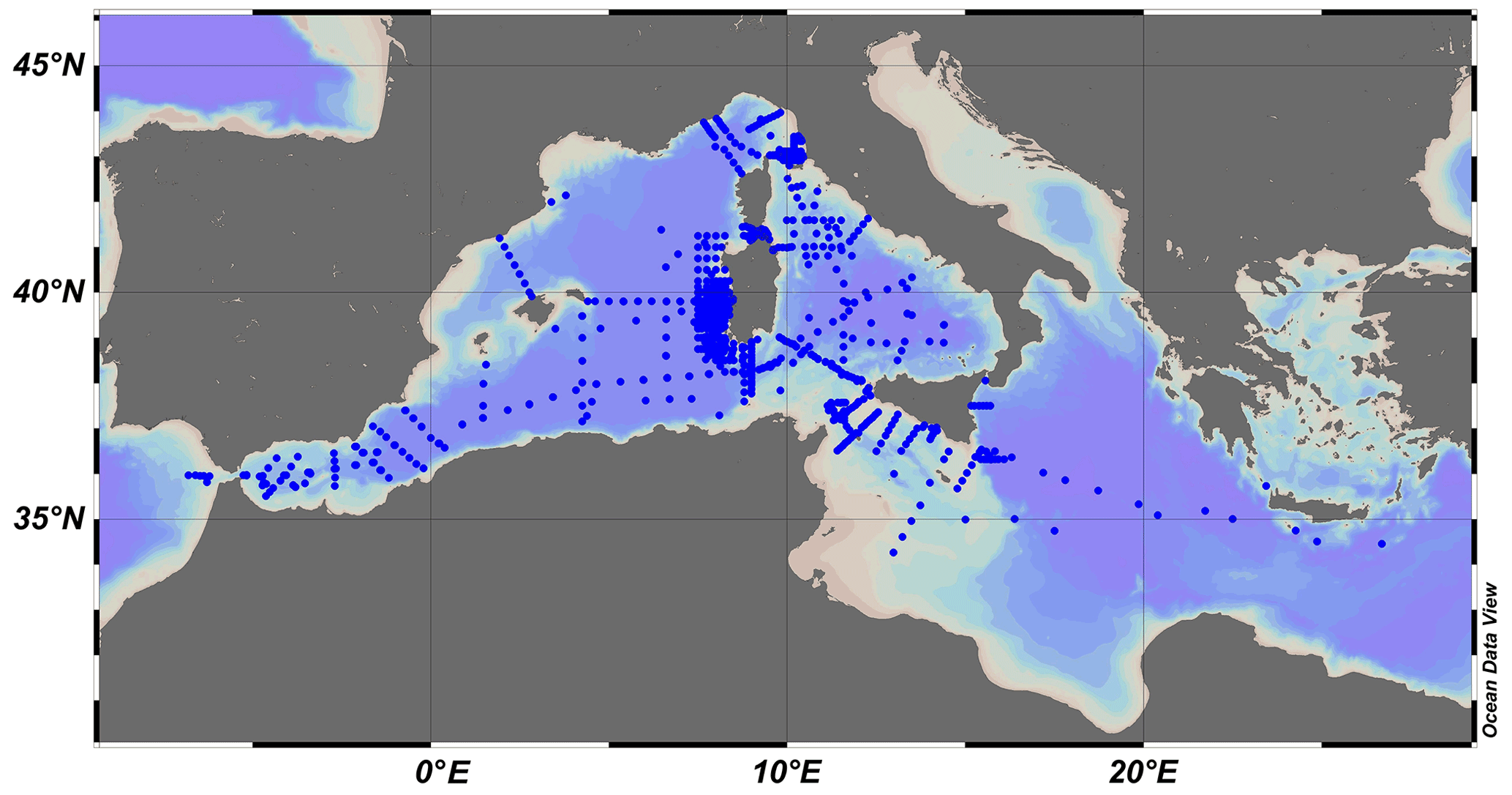
Figure 1All the conductivity, temperature, and depth (CTD) casts acquired during the 29 cruises in the Mediterranean Sea between 2000 and 2020.
Table 1List of cruises carried out from 2000 to 2020. Areas with at least three casts are listed. Ocean parameters are listed with acronyms, so P stands for pressure, C for conductivity, T for temperature, O for dissolved oxygen, F for fluorescence, Tu for turbidity, CD for CDOM (chromophoric dissolved organic matter), and pH is just pH.
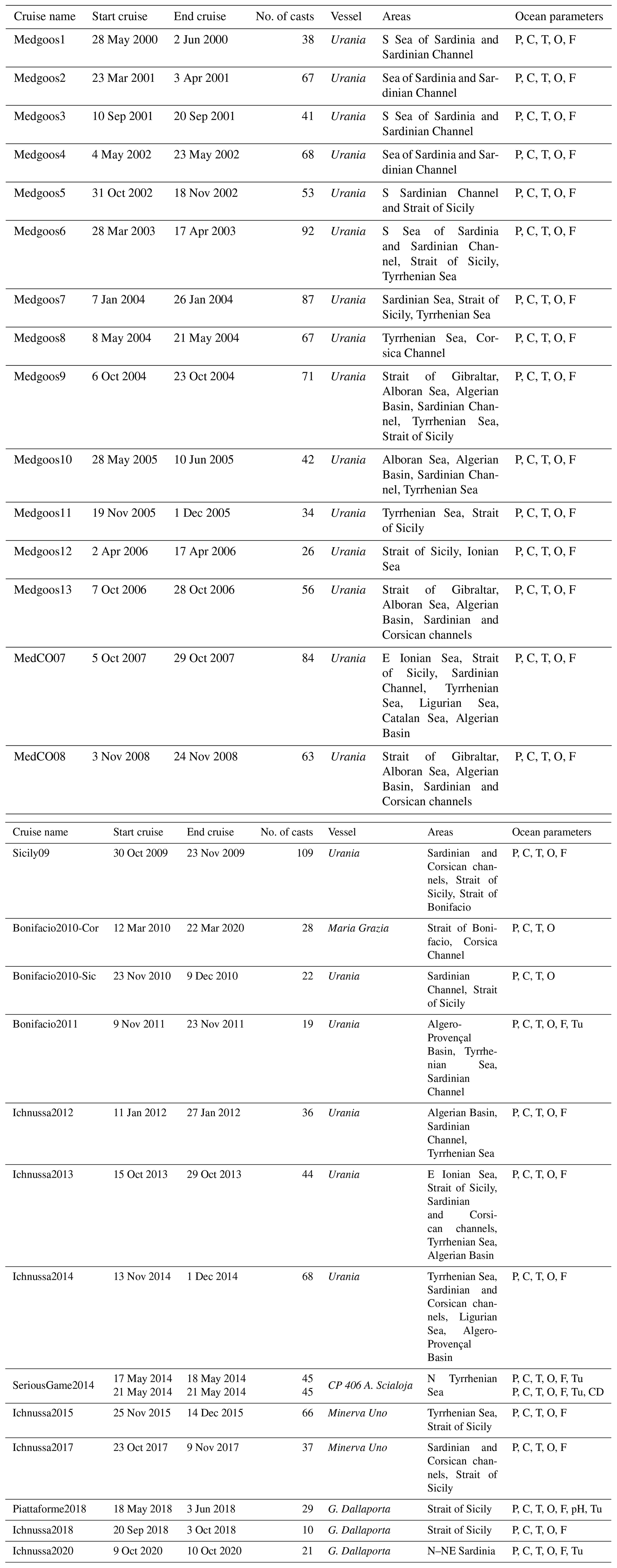
Over 29 oceanographic cruises were realized in the Mediterranean basin between May 2000 and October 2020 (Table 1 and Fig. 1) by the CNR in Oristano jointly with the CNR in Spezia, except for the years 2016 and 2019 when no cruises were carried out. The strict collaboration, from 2000 till 2018, with the CNR institute in La Spezia, which has much longer experience with ocean cruises and studies, has offered the choice of some sampling plans like the transects in the Strait of Sicily and Corsica Channel, where they moored deep oceanographic chains for tens of years.
In total, 1468 hydrological vertical profiles were acquired in 21 years in the Mediterranean Sea, covering areas spanning from the Strait of Gibraltar in the western sub-basin to the south of Crete in the eastern part of the Mediterranean Sea.
In addition to the projects' objectives and further research interests, two more aspects have influenced, even heavily in the last 4 years, data acquisition, i.e., sea conditions and type of vessel (described in the next subsection). Until 2017 (Table 1), the availability of large research CNR vessels like Urania and Minerva Uno allowed working throughout the Mediterranean and in less than optimal sea conditions, whereas, since 2018, the available research vessels have not been suitable for working in rough sea conditions in the open sea.
2.1 Research vessels and projects
Different research vessels (R/Vs) were used during several measuring campaigns, each one with characteristics and facilities that influenced both sampling plans and data acquisition. Between May 2000 and December 2017, the CNR used two multidisciplinary research vessels designed in Italy that permitted researchers to work all over the Mediterranean and in all seasons. These vessels are the 61.30 m long R/V Urania (2000–2014) and the 47.66 m long R/V Minerva Uno (2015–2017). During these years, the cruises allowed us to acquire data to study the local (e.g., the Sea of Sardinia till 2004) and the general circulation all over the Mediterranean, to maintain deep-ocean bottom-moored infrastructures in the Corsican and Sardinian channels and the Strait of Sicily, and to acquire data to calibrate and validate numerical models at different spatial scales. In 2016, no cruise was planned.
In March 2010, the 42.35 m long R/V Maria Grazia was used just for the cruise of Bonifacio2010-Cor, for a project in the Strait of Bonifacio area, where an oceanographic and oil spill prediction system based on numerical models was realized for the local coast guard.
During the years 2018–2020, the 35.7 m long R/V G. Dallaporta, a coastal vessel particularly suitable for activities related to scientific fishing and marine biology, was used in research projects mainly focused on coastal measurements and the launch/rescue of Lagrangian surface drifters in southern Sicily and Sardinia. In 2019, the 8 d long cruise Ichnussa2019 was canceled due to bad weather conditions.
In May 2014, the 21.5 m long patrol boat CP 406 A. Scialoja, a unit of the Italian Coast Guard, was used during a set of two daily surveys, named SeriousGame2014-1 and SeriousGame2014-2, performed in the Tuscan Archipelago, in the northern Tyrrhenian Sea. Data were acquired to test one of the limited ocean forecast models for the oil spill fate (Gonnelli et al., 2016; Sorgente et al., 2016), which is part of the wider Mediterranean decision support system (Zodiatis et al., 2016).
2.2 Sensors and data
For all the adopted vessels, the hydrological instruments were mounted on a General Oceanics Rosette system with 24×12 L Niskin bottles for water column samples collection (2×10 L during the cruise of Bonifacio2010-Cor). This system was equipped with a SBE911plus CTD (conductivity, temperature, and depth) probe (Sea-Bird Scientific, hereafter SBE Sci.), which sampled the hydrological parameters along the vertical at 24 Hz and with a lowering speed of 1 m s−1. With the CTD, the data of water conductivity were measured by a SBE 4 sensor, with a resolution of S m−1, the water temperature was measured by means of a SBE 3F thermometer, with a resolution of 0.00015 ∘C/bit at −1 ∘C or 0.00018 ∘C/bit at 31 ∘C, and the dissolved oxygen (DO) was measured by means of a SBE 13, with a resolution of 4.3 µM, from Medgoos1 to 4, and then using a SBE 43 polarographic membrane sensor with a range of 120 % of surface saturation and an accuracy of ±2 % for saturation. The chlorophyll a fluorescence was reported as a relative fluorescence unit (Chl a), by means of a Sea Tech fluorometer with energy emitted by the flash lamp of 0.25 J for flash, with a temperature range between 0 and 25 ∘C and a resolution of 0.15 g L−1.
Since the cruise of Medgoos12, in April 2006, the Chelsea Aqua 3 fluorometer has been used, whereas, due to sensor malfunction, no fluorescence data were collected during the Medgoos11 and the two cruises of Bonifacio2010-Sic and Bonifacio2010-Cor. Turbidity was acquired only during Bonifacio2011 by a Seapoint turbidity meter and by a WET Labs Environmental Characterization Optics (ECO)-NTU during Piattaforme2018 and Ichnussa2020. The pH/redox sensor (SBE 27) was available only during the cruise of Piattaforme2018, but it had been calibrated 1 year before. During cruises from Medgoos5 to Medgoos7, temperature data were checked on board at defined depths against inverted thermometers, i.e., model RTM 4002 by Sensoren Instrumente Systeme GmbH (SiS), installed in correspondence with the Niskin bottles numbered 1, 3, 5, and 7 of the Rosette sampler.
Since the cruise of Medgoos2 in March–April 2001 (see Table 1), redundant or secondary sensors have always been used for a data quality assessment (as defined in Bushnell et al., 2019) for measurements of temperature, salinity, and dissolved oxygen (this is from Medgoos5 in October 2022; Table 1). These secondary sensors were used to evaluate the stability of primary ones on board and during the following visual data quality check.
Pre-cruise and post-cruise calibrations of first and redundant sensors of temperature, salinity, and dissolved oxygen were performed by CNR technicians at the NATO Centre for Maritime Research and Experimentation (CMRE) in La Spezia (Italy). These two calibrations permitted us to obtain a slope correction, used in the configuration file of the SBE Seasoft™ suite of programs, improving the data quality. The post-cruise calibration was not performed on data acquired during the cruise of Piattaforme2018. After their acquisition, data were pre-processed by the SBE Data Processing™ software with the updated configuration file to correct coarse errors. Data from the redundant sensor were used instead of the primary data in case of malfunction (Ribotti et al., 2020).
But, despite their double calibrations, during a cruise all sensors can drift, thereby reducing their data quality. For conductivity and dissolved oxygen sensors, their stability was checked through onboard comparisons with data from water samples. On board R/V Urania (2000–2014) and R/V Minerva Uno (2015–2017), salinity was checked against the onboard analyses of water, sampled at pre-defined depths, by a Guildline™ Autosal 8400B Laboratory Salinometer, while on the other vessels all samples were analyzed once back at CNR (Ribotti et al., 2020). The same applied for dissolved oxygen measurements that were checked onboard against the Winkler titration method (Winkler, 1888) and analyzed through the program tiamo™ 2.0 by Metrohm.
Finally, Chl a, pH, and turbidity data were not calibrated. The pressure sensor is usually stable, and so it is not calibrated but, in case of malfunction, it was sent to SBE Sci. in the USA to be revised.
During all cruises, dissolved inorganic nutrients were also acquired from water samples, and analyses were carried out once back in the laboratory. Data from Medgoos8 in May 2004 and Ichnussa2017 in October–November 2017 are available online (Belgacem et al., 2019) and described, in their quality check procedures, in Belgacem et al. (2020).
Furthermore, in the framework of the MEDESS4MS project (see info at https://keep.eu/, last access: 5 September 2022), on 17 and 21 May 2014, two daily cruises, SeriousGame2014-1 and SeriousGame2014-2, were jointly held by the CNR in Oristano, the CNR in Ancona, and the Italian Coast Guard. The two surveys covered, with 45 casts each, about 880 km2 of a shelf on a 5×5 km in latitude and longitude spatial grid of an area located north of Elba island in the Tuscan Archipelago in the northern Tyrrhenian Sea. The CTD probe was a Seabird SBE 19 plus v2 equipped with sensors of pressure, temperature, conductivity, SBE 63 for dissolved oxygen, a WET Labs FLNTU for fluorescence and turbidity (NTU), and chlorophyll a (µg L−1) and, just during the second cruise, a Turner Cyclops sensor for the chromophoric dissolved organic matter (CDOM in parts per billion, ppb, of quinine sulfate, QS). The probe was calibrated on 29 January 2013 at SBE Sci. in the USA, but not before and after the two cruises, so the data were just quality checked and processed by the SBE Data Processing™ software to correct the coarse errors.
All CTD data listed in Table 1 are available in the SEANOE (SEA ScieNtific Open data Edition) data repository (Ribotti et al., 2019a, b, c, 2022), where each dataset is identified per cruise and provided in the Ocean Data View (ODV; Schlitzer, 2022) ASCII file format, with missing values set to .
Methodologies before, during, and after any acquisition, instruments, and personnel changed a little during the 21 years of CTD acquisitions, apart from during the two coastal cruises of SeriousGame2014-1 and SeriousGame2014-2 in 2014, due to different adopted instruments. This makes the data in the datasets highly coherent and comparable.
In 21 years, projects and scientific interests led to the choice of areas and sampling plans that could change in relation to vessel characteristics and sea conditions. Nevertheless, repetitions of casts were realized, like in the Sea of Sardinia, where the same sampling strategy was repeated for seven cruises in 5 years, or the sampling transects between Sardinia and the Balearic Islands, across the Strait of Sicily and the Corsica Channel, and along the western Mediterranean (see in Table 1), mainly for oceanographic studies like circulation, hydrology, and their variabilities. In the following subsections, a process and an oceanographic event, observed from the data described in this paper, are mentioned to suggest further scientific research interests and opportunities for using these data.
In the first subsection, we show the step structures observed during the first four Medgoos cruises between 2000 and 2002 in the Sea of Sardinia but also during other cruises in the western Mediterranean. In the following subsection, we describe studies on the Western Mediterranean Transient that were detected in the datasets acquired between 2005 and 2017.
3.1 Step structures in the deep Sea of Sardinia
The first seven cruises named Medgoos have been organized to cover the Sea of Sardinia either partially or totally. Casts were realized on a regular 25 km grid from the shelf to the abyssal plain, which are some hundreds of kilometers from the coast. The integration of numerical models' solutions and satellite images permitted the study of the circulation in the Sea of Sardinia (Ribotti et al., 2004; Puillat et al., 2006). It is mainly characterized by fresher modified Atlantic Water (AW) in the upper 200 m, warmer and saltier Levantine Intermediate Water (LIW) below and till 800 m depth, moving northward along the Sardinian slope, and the Western Mediterranean Deep Water (WMDW) between 800 m and the abyssal plain. Due to baroclinic instabilities of the Algerian Current, surface and intermediate waters are dynamically affected by the presence of deep anticyclonic Algerian eddies (AEs) along the Sardinian coast, involving surface and intermediate waters till 1500 m depth (Puillat et al., 2006) and reaching a latitude around 40∘ N (Puillat et al., 2002; Pessini et al., 2020). Waters are also affected by the Sardinian eddies, formed by the interaction of the westward flux of LIW and Tyrrhenian Deep Water (TDW) coming from the Tyrrhenian Sea with the Algerian gyres at the southwestern Sardinian corner, which influence the circulation of intermediate and deep circulation (Testor and Gascard, 2005; Testor et al., 2005). Cruises of Medgoos2, Medgoos4, and Medgoos7 (in March 2001, May 2002, and January 2004, respectively; see Table 1) covered the whole Sea of Sardinia, permitting us to investigate some hydrological profiles from March 2001 and repeat some casts hundreds of kilometers from Sardinia. AEs were observed during the first two cruises in the southern central part of the Sea of Sardinia (Puillat et al., 2006), while in January 2004 the area was eddy free. The profiles from these three cruises showed step structures at latitudes between 40.5 and 41.5∘ N offshore of northwestern Sardinia at depths between 500 and 1400 m. Following the method proposed by Durante et al. (2019) to investigate the staircase systems in the central Tyrrhenian Sea, the analysis of data collected during Medgoos cruises always revealed a five- to nine-step structure, with interfaces 50–110 m thick, located between intermediate and deep waters, as depicted by the profiles of absolute salinity and conservative temperature reported in Fig. 2.

Figure 2Some of the steps observed offshore of northwestern Sardinia, between 500 and 1500 m, through the profiles of absolute salinity and conservative temperature at the interface of intermediate–deep waters in the period of March 2001–January 2004.
During the first cruise conducted in March 2001, the staircase structure was less evident than in 2002 and 2004. Each step is defined by a layer with values of the stability ratio (RP) and of the Turner angle (Tu) finger regime, both defined in Durante et al. (2019), which comprised between 1 and 1.7 () and between 45 and 90∘ (45∘ ∘), respectively. Following Durante et al. (2019), these staircase systems can be defined with rough profiles, representing instabilities in the convective layer, and characterized by a reduced number of thick steps alternated by rough interfaces. The ranges of the differences in the temperature and salinity at the interface of each step ranged between and ∘C and between and PSU (Practical Salinity Unit), respectively, with an interface thickness varying between 9 and 40 m. These values are comparable with those observed in the Tyrrhenian Sea by Zodiatis and Gasparini (1996), with the difference that the central Tyrrhenian Sea is a low-energy area in terms of water currents, whereas the northern Sea of Sardinia is at the limits of the passage of deep anticyclonic eddies moving anti-clockwise in the Algerian sub-basin and generating intense currents (Pessini et al., 2018, 2020).
Staircase systems were also found in the central Algero-Provençal Basin during the Bonifacio2011 (November 2011) and Ichnussa2012 (January 2012) cruises and were well identified from the analysis of the profiles of absolute salinity and the conservative temperature profile, as reported in Fig. 3.
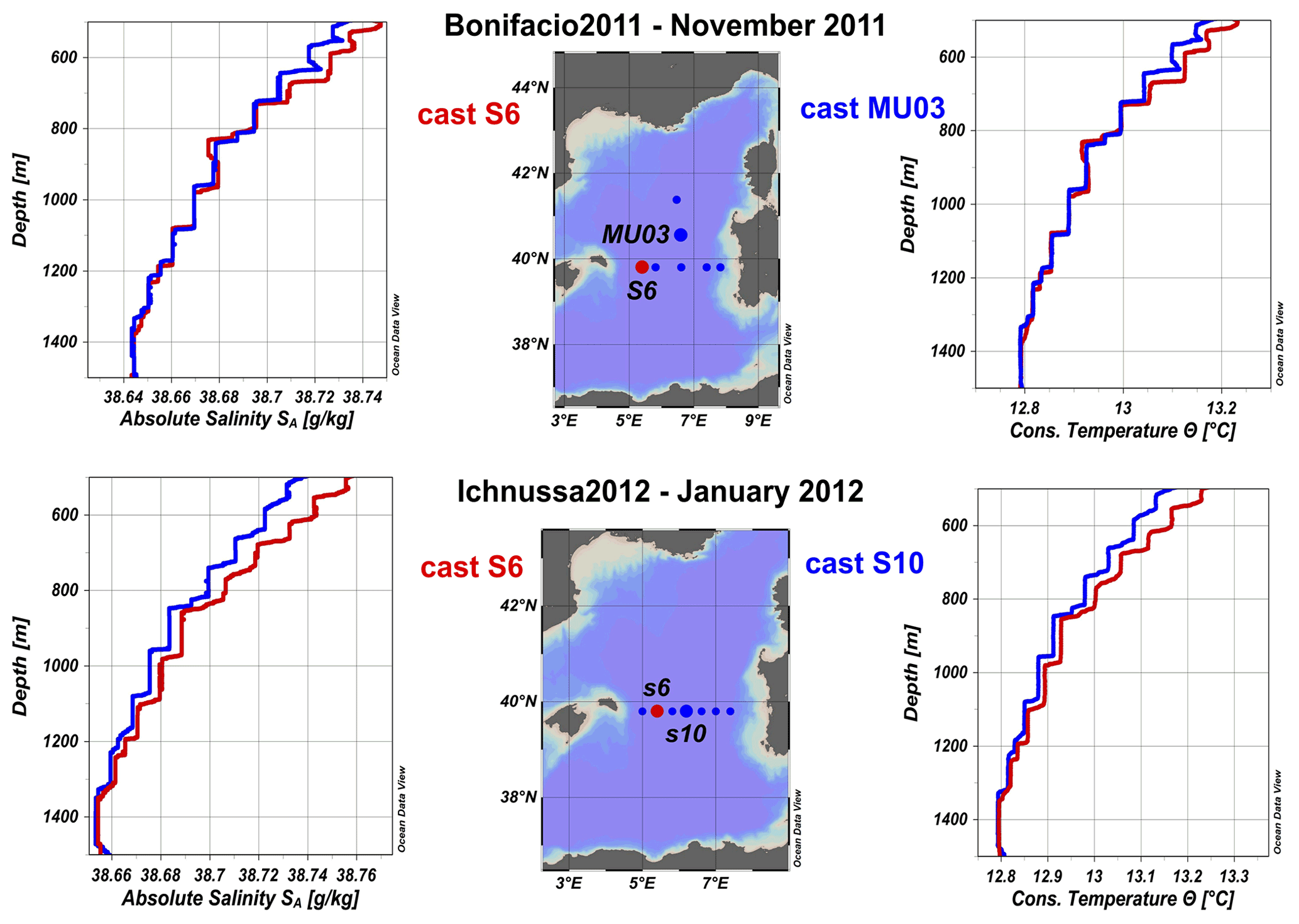
Figure 3Profiles of absolute salinity and conservative temperature of two casts where the steps were observed along the transect between the Balearic Islands and Sardinia at 500–1500 m depth in the period of November 2011–January 2012.
These staircases are organized in seven- to nine-step structures, with interfaces 60–110 m thick and RP and Tu comparable with those observed offshore of northwestern Sardinia. These systems were detected in sampling stations located in the central Provençal sub-basin and in the central part of the transect between the Menorca island in the Balearic Islands and Oristano in Sardinia, along a latitude at around 40∘ N. They are similar to those described by Fuda et al. (2000), who observed them between 500 and 1400 m depths from CTD and expendable bathythermograph (XBT) profiles acquired in February 1994 in the open Algerian area.
The features of these dynamical structures confirm that they are related to salt fingering that originated in the presence of intermediate waters, both when close to the continental slopes (NW Sardinia) and when in the middle of the Algero-Provençal area. In both cases, their presence is probably dependent on the absence of eddies that, if deep, can erode the step structure, which is in agreement with what observed in June 2017 by Taillandier et al. (2020) in the Algerian Basin along the 38∘ N parallel. Finally, during the 12 cruises between March 2003 (Medgoos6) and December 2015 (Ichnussa2015), the 3550 m deep cast number 51 in the central Tyrrhenian Sea was repeated to study the staircase system previously mentioned and recently well described by Durante et al. (2019).
3.2 Deep changes in the western Mediterranean sub-basin
In the Mediterranean, the deep circulation is organized in two deep cells, located in the western and eastern sub-basin, respectively, and is constituted by denser waters than those above whose thermohaline features can differ between the two sub-basins (Malanotte-Rizzoli et al., 1997; Sparnocchia et al., 1999; Wu et al., 2000; Bethoux et al., 2002; Rixen et al., 2005; Marty and Chiavérini, 2010; Bensi et al., 2013; Ingrosso et al., 2017; Send and Testor, 2017).
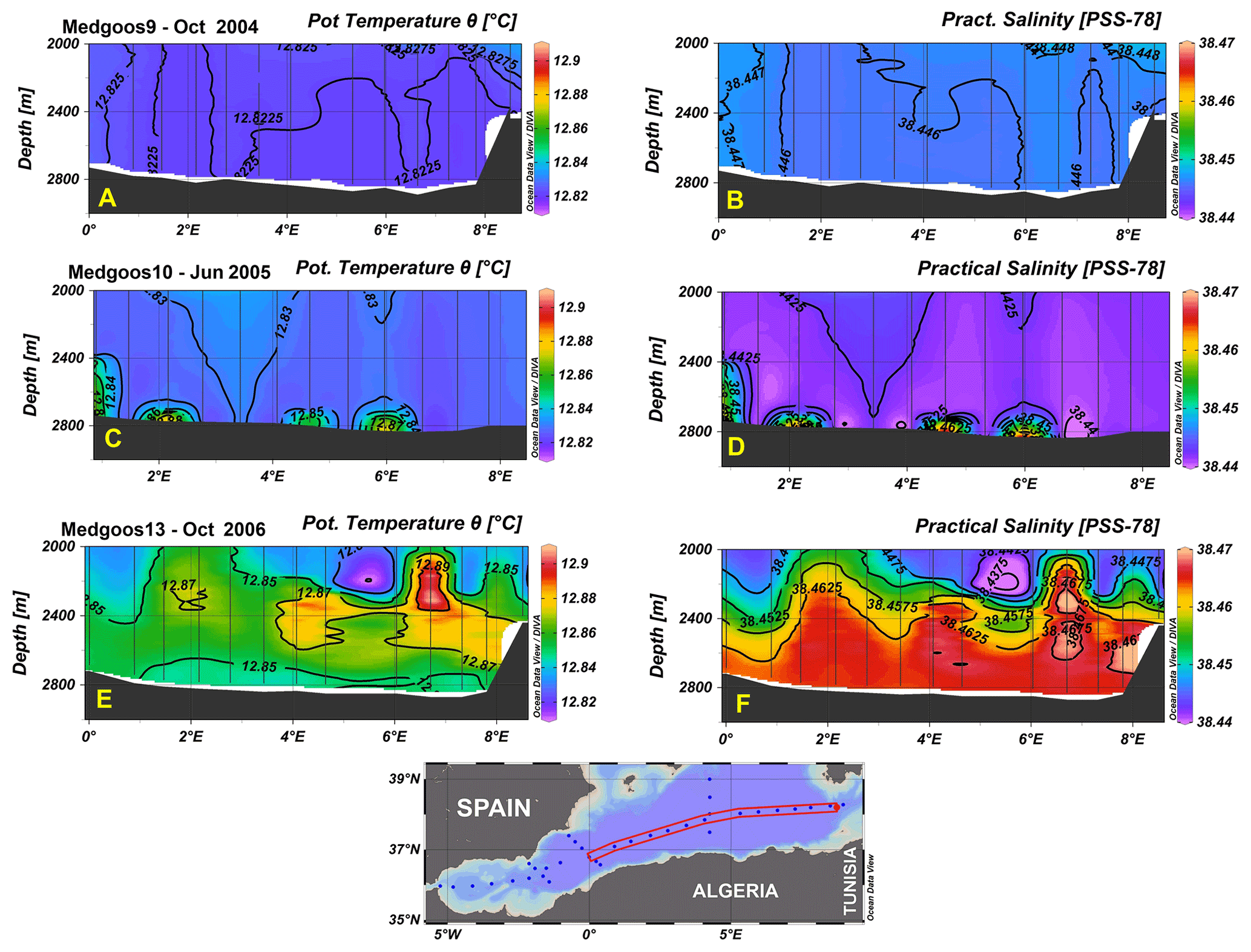
Figure 4Deep sections (over 2000 m depth) of potential temperature (∘C) and practical salinity (dimensionless) along a transect at 37–37.5∘ N between the eastern entrance to the Alboran Sea (0∘ E) and the western entrance to the Sardinian Channel (8.5∘ E) during the cruises Medgoos9 (a and b; October 2004) before the Western Mediterranean Transient (WMT), Medgoos10 (c and d; May–June 2005), and Medgoos13 (e and f; October 2006) with the filling of the Algerian sub-basin by the WMT.
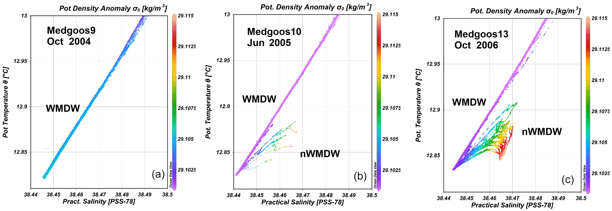
Figure 5Potential temperature and practical salinity (θS), with the potential density anomaly (σθ; kg m3) of the casts along the transect of Fig. 4 during the cruises Medgoos9 (a; October 2004) before the WMT, Medgoos10 (b; May–June 2005), and Medgoos13 (c; October 2006) with the typical hooks and inversions of the new deep water characteristics.
Between October 2004 (Medgoos9) and 2017 (Ichnussa2017), 15 cruises covered some deep sub-basins of the western and central Mediterranean, from the Strait of Sicily and the Tyrrhenian Sea over to the Strait of Gibraltar, with hydrological casts (see Table 1). These data, apart from the shallow cruise Bonifacio2010-Cor and the two SeriousGame cruises in 2014, have permitted us to follow the spreading of the new Western Mediterranean Deep Waters (nWMDW) in the western Mediterranean sub-basins since its formation in 2005 (Schroeder et al., 2008), revealing over a decade of great thermohaline variability. During winter 2004/2005, above the northwestern Mediterranean area, a little rain with intense and persistent northerly winds brought a massive heat loss in the Gulf of Lions, the highest since 1948, that led to an increase in surface salinity (Font et al., 2007). In the same years, the propagation of the Eastern Mediterranean Transient, from the eastern to the western basin of the Mediterranean, led to maximum values of temperature and salinity in the intermediate layers (Gasparini et al., 2005; Lopez-Jurado et al., 2005; Schroeder et al., 2006; Margirier et al., 2020). The concomitance of these meteorological and oceanographic processes has created the perfect conditions for the formation of warmer and saltier deep waters than the pre-existing ones (Herrmann et al., 2010; López-Jurado et al., 2005), which then occupy the deepest layer close to the bottom and are known as the Western Mediterranean Transient (WMT; López-Jurado et al., 2005; Schroeder et al., 2008; Briand, 2009; Zunino et al., 2012). After the first event of 2004/2005, WMT continued with large volumes of nWMDW formed in winter 2005/2006 (Medgoos10 and Medgoos13 in Fig. 4), while in the following winters of 2006/2007 and 2007/2008, no deep water production occurred due to a mild cold season. But deep convection started again in winter 2008/2009 and in the following (i.e., 2009/2010, 2010/2011, and 2011/2012) winters, due to particularly cold weather, as in 2011/2012, in the Mediterranean Sea. In 2012, and at the bottom of the Gulf of Lions, the nWMDW had a potential temperature of 12.905 ∘C, a salinity of 38.508 and a maximum density of 29.134 kg m−3 (Durrieu de Madron et al., 2013). A mere 6 years earlier, and at the bottom of the Algerian Basin (Medgoos13 in 2006), values were lower, with 12.845 ∘C, 38.465, and 29.115 kg m−3 of potential temperature, salinity, and density, respectively, as shown in Figs. 4e and f and 5c.
Every winter, new warmer, saltier, and denser deep waters formed, moving to a continuous increase in the heat and salt content in the deep layer, making the deep temperature–salinity (θS) diagrams more and more complex (Schroeder et al., 2016). The replacement of the old deep waters near the bottom by new ones is visible as a creep close to the bottom in 2005 and becoming 600 m thick in 2006, almost 1000 m thick in 2008, over 1200 m in 2010, 1400 m in 2013, and >1500 m in 2015. Since 2010, the signal of the WMT has been found also in the Tyrrhenian Sea, after having overpassed the Sardinian Trough, connecting the Algerian sub-basin with the Tyrrhenian one along the axis of the Sardinian Channel. The WMT changed the structure and properties of the deep layers in the western Mediterranean, which is recognizable by the hooks and inversions in characteristic θS diagrams (in Fig. 5, in comparison with Medgoos9 data prior to the WMT). This set of CTDs acquired during over a decade (2004–2017) can contribute to the understanding of the temporal and spatial evolution of the thermohaline variability in the western Mediterranean Sea. The thermohaline circulation of the Mediterranean Sea, through the Mediterranean Outflow Water (MOW), has a particular impact on the North Atlantic circulation and the Atlantic Meridional Overturning Circulation (AMOC) due to its high salinity, as rebuilt in paleoceanographic studies (Rogerson et al., 2012; van Dijk et al., 2018; Ausín et al., 2020; Mesa-Fernández et al., 2022).
The four datasets described in this study are publicly available and available free of charge from the SEANOE data repository as Ribotti et al. (2019a, b, c) at https://doi.org/10.17882/59867, https://doi.org/10.17882/59777, and https://doi.org/10.17882/70340, respectively, and as Ribotti et al. (2022) at https://doi.org/10.17882/87567. The presented datasets are composed of CTD data in Ocean Data View (ODV) .txt spreadsheet files, with one for each cruise (Schlitzer, 2022).
Over 1468 hydrological vertical profiles were acquired during 29 oceanographic cruises in 21 years in the Mediterranean Sea, with a particular focus on the western and central Mediterranean sub-basins, between May 2000 and October 2020. Each cruise was mainly led by the project objectives funding the research but also by scientific interests at different spatial (coastal or offshore) and temporal (from days to years) scales. The use and reuse of data with time was mainly driven by the following issues: solution of marine environmental problems, studies on ocean circulation and variability, and/or model validation. This is visible in the different spatial resolution of the sampling plans, on a regular grid of casts, or along repeated transects, sometimes with both being used during the same cruise.
During the years, and despite some improvements in sensor quality, sensors and instruments were prepared through the same procedures before and after their use and had the same quality assurance protocols, apart from the two SeriousGame cruises in 2014. CTD data followed all quality check, assessment, standard, and best practices, as defined at an international level (see Bushnell et al., 2019) and through standardized procedures for all sensors (Hood et al., 2010). Pre- and post-calibration, redundant sensors, and water samples analyzed onboard have achieved the best accuracy standard for the instruments used. The presence of the same operators on board for most of the cruise years has assured a reduced uncertainty of the measurements, further increasing the quality of the dataset.
The final results are coherent datasets of CTD data that can be used for all studies, as described in the paper for the WMT or for salt fingering.
AR led some projects and cruises, acquired funding and data, finalized the data quality procedures described in the paper, realized the datasets, and wrote the paper. MB led some cruises, finalized data quality procedures described in the paper, realized the datasets, and collaborated on the writing of the paper. RS and AC led some projects, acquired funding and data, and collaborated on the data analyses and the writing of the paper with FP and GQ.
The contact author has declared that none of the authors has any competing interests.
Publisher's note: Copernicus Publications remains neutral with regard to jurisdictional claims in published maps and institutional affiliations.
We thank captains and crews on R/V Urania, R/V Maria Grazia, R/V Minerva Uno, CP-406 Antonio Scialoja, and R/V G. Dallaporta for their essential support on board and Paschini Ezio and Penna Pierluigi from CNR in Ancona for their support during the cruises of SeriousGame2014. Finally, we thank Mario Astraldi and Salvatore Mazzola (deceased in January 2021) for their support and suggestions in the first 10 years of our work at sea.
Cruises mentioned were supported by national and European projects of which the most important are the EU projects MyOcean (contract no. 218812) and MyOcean2 (contract no. 283367), the MED programme project MEDESS4MS (agreement no. MED2S-MED11-01), the Italian MATTM project SOS-BONIFACIO (prot. DPN-2009-0001027 of 20/01/2009), the Italian MIUR project PON TESSA (agreement no. PON01_02823), the EU project COMMON SENSE (contract no. 614155), the Italian MATTM project SOS-Piattaforme & Impatti offshore (Reg. Uff. U. 0000939.17-01-2017), and the 2014–2020 Interreg V-A Italy–France Maritime project SICOMAR Plus (IAS CNR Prot. 0001156/2018 of 12 December 2018).
This paper was edited by Giuseppe M. R. Manzella and reviewed by two anonymous referees.
Ausín, B., Hodell, D. A., Cutmore, A., and Eglinton, T. I.: The impact of abrupt deglacial climate variability on productivity and upwelling on the southwestern Iberian margin, Quat. Sci. Rev., 230, 106139, https://doi.org/10.1016/j.quascirev.2019.106139, 2020.
Belgacem, M., Chiggiato, J., Borghini, M., Pavoni, B., Cerrati, G., Acri, F., Cozzi, S., Ribotti, A., Álvarez, M., Lauvset, S. K., and Schroeder, K.: Quality controlled dataset of dissolved inorganic nutrients in the western Mediterranean Sea (2004–2017) from R/V oceanographic cruises, PANGAEA, https://doi.org/10.1594/PANGAEA.904172, 2019.
Belgacem, M., Chiggiato, J., Borghini, M., Pavoni, B., Cerrati, G., Acri, F., Cozzi, S., Ribotti, A., Álvarez, M., Lauvset, S. K., and Schroeder, K.: Dissolved inorganic nutrients in the western Mediterranean Sea (2004–2017), Earth Syst. Sci. Data, 12, 1985–2011, https://doi.org/10.5194/essd-12-1985-2020, 2020.
Bensi, M., Rubino, A., Cardin, V., Hainbucher, D., and Mancero-Mosquera, I.: Structure and variability of the abyssal water masses in the Ionian Sea in the period 2003–2010, J. Geophys. Res.-Oceans, 118, 931–943, https://doi.org/10.1029/2012JC008178, 2013.
Bethoux, J. P., Gentili, B., Morin, P., Nicolas, E., Pierre, C., and Ruiz-Pino D.: The Mediterranean Sea: a miniature ocean for climatic and environmental studies and a key for the climatic functioning of the North Atlantic, Prog. Oceanogr., 44, 131–146, https://doi.org/10.1016/S0079-6611(99)00023-3, 1999.
Bethoux, J. P., Durieu de Madron, X., Nyffeler, F., and Tailliez, D.: Deep water in the western Mediterranean: peculiar 1999 and 2000 characteristics, shelf formation hypothesis, variability since 1970 and geochemical inferences, J. Mar. Syst., 33–34, 117–131, https://doi.org/10.1016/S0924-7963(02)00055-6, 2002.
Briand, F. (Ed.): Dynamics of Mediterranean deep waters, No. 38, CIESM, Workshop Monographs, 132 pp., Monaco, 2009.
Bushnell, M., Waldmann, C., Seitz, S., Buckley, E., Tamburri, M., Hermes, J., Henslop, E., and Lara-Lopez, A.: Quality Assurance of Oceanographic Observations: Standards and Guidance Adopted by an International Partnership, Front. Mar. Sci., 6, 706, https://doi.org/10.3389/fmars.2019.00706, 2019.
Durante, S., Schroeder, K., Mazzei, L., Pierini, S., Borghini, M., and Sparnocchia, S.: Permanent thermohaline staircases in the Tyrrhenian Sea, Geophys. Res. Lett., 46, 1562–1570, https://doi.org/10.1029/2018GL081747, 2019.
Durrieu de Madron, X., Houpert, L., Puig, P., Sanchez-Vidal, A., Testor, P., Bosse, A., Estournel, C., Somot, S., Bourrin, F., Bouin, M.-N., Beauverger, M., Beguery, L., Calafat, A., Canals, M., Coppola, L., Dausse, D., D'Ortenzio, F., Font, J., Heussner, S., and Raimbault, P.: Interaction of dense shelf water cascading and open-sea convection in the Northwestern Mediterranean during winter 2012, Geophys. Res. Lett., 40, 1379–1385, https://doi.org/10.1002/grl.50331, 2013.
Font, J., Puig, P., Salat, J., Palanques, A., and Emelianov, M.: Sequence of hydrographic changes in NW Mediterranean deep water due to the exceptional winter of 2005, Sci. Mar., 72, 339–346, https://doi.org/10.3989/scimar.2007.71n2339, 2007.
Fuda, J. L., Millot, C., Taupier-Letage, I., Send, U., and Bocognano, J. M.: XBT monitoring of a meridian section across the western Mediterranean Sea, Deep-Sea Res. Pt. I, 47, 2191–2218, https://doi.org/10.1016/S0967-0637(00)00018-2, 2000.
Gasparini, G., Ortona, A., Budillon, G., Astraldi, M., and Sansone, E.: The effect of the Eastern Mediterranean Transient on the hydrographic characteristics in the Strait of Sicily and in the Tyrrhenian Sea, Deep-Sea Res. Pt. I, 52, 915–935, https://doi.org/10.1016/j.dsr.2005.01.001, 2005.
Gonnelli, G., Galletti, Y., Marchetti, E., Mercadante, L., Retelletti Brogi, S., Ribotti, A., Sorgente, R., Vestri, S., and Santinelli, C.: Dissolved organic matter dynamics in surface waters affected by oil spill pollution: Results from the Serious Game exercise, Deep-Sea Res. Pt. II, 133, 88–99, https://doi.org/10.1016/j.dsr2.2016.05.027, 2016.
Herrmann, M., Sevault, F., Beuvier, J., and Somot, S.: What induced the exceptional 2005 convection event in the northwestern Mediterranean basin? Answers from a modeling study, J. Geophys. Res., 115, C12051, https://doi.org/10.1029/2010JC006162, 2010.
Hood, E. M., Sabine, C. L., and Sloyan, B. M. (Eds.): The GO-SHIP Repeat Hydrography Manual: A Collection of Expert Reports and Guidelines. IOCCP Report No.14, ICPO Publication Series No. 134, http://www.go-ship.org/HydroMan.html (last access: 25 May 2022), 2010.
Ingrosso, G., Bensi, M., Cardin, V., and Giani, M.: Anthropogenic CO2 in a dense water formation area of the Mediterranean Sea, Deep-Sea Res. Pt. I, 123, 118–128, https://doi.org/10.1016/j.dsr.2017.04.004, 2017.
López-Jurado, J.-L., González-Pola, C., and Vélez-Belchí, P.: Observation of an abrupt disruption of the long-term warming trend at the Balearic Sea, western Mediterranean Sea, in summer 2005, Geophys. Res. Lett., 32, L24606, https://doi.org/10.1029/2005GL024430, 2005.
Malanotte-Rizzoli, P., Manca, B. M., Ribera D'Alcalà, M., Theocharis, A., Bergamasco, A., Bregant, D., Budillon, G., Civitarese, G., Georgopoulos, D., Michelato, A., Sansone, E., Scarazzato, P., and Souvermezoglou, E.: A synthesis of the Ionian Sea hydrography, circulation and water mass pathways during POEM-Phase I, Prog. Oceanogr., 39, 153–204, https://doi.org/10.1016/S0079-6611(97)00013-X, 1997.
Margirier, F., Testor, P., Heslop, E., Mallil, K., Bosse, A., Houpert, L., Mortier, L., Bouin, M.-N., Coppola, L., D'Ortenzio, F., de Madron, X. D., Mourre, B., Prieur, L., Raimbault, P., and Taillandier, V.: Abrupt warming and salinification of intermediate waters interplays with decline of deep convection in the Northwestern Mediterranean Sea, Sci. Rep.-UK, 10, 20923, https://doi.org/10.1038/s41598-020-77859-5, 2020.
Marty, J. C. and Chiavérini, J.: Hydrological changes in the Ligurian Sea (NW Mediterranean, DYFAMED site) during 1995–2007 and biogeochemical consequences, Biogeosciences, 7, 2117–2128, https://doi.org/10.5194/bg-7-2117-2010, 2010.
Mesa-Fernández, J. M., Martínez-Ruiz, F., Rodrigo-Gámiz, M., Jiménez-Espejo, F. J., García, M., and Sierro, F. J.: Paleocirculation and paleoclimate conditions in the western Mediterranean basins over the last deglaciation: new insights from sediment composition variations, Glob. Planet. Change, 209, 103732, https://doi.org/10.1016/j.gloplacha.2021.103732, 2022.
Pessini, F., Olita, A., Cotroneo, Y., and Perilli, A.: Mesoscale eddies in the Algerian Basin: do they differ as a function of their formation site?, Ocean Sci., 14, 669–688, https://doi.org/10.5194/os-14-669-2018, 2018.
Pessini, F., Cotroneo, Y., Olita, A., Sorgente, R., Ribotti, A., Jendersie, S., and Perilli, A.: Life history of an anticyclonic eddy in the Algerian basin from altimetry data, tracking algorithm and in situ observations, J. Mar. Syst., 207, 103346, https://doi.org/10.1016/j.jmarsys.2020.103346, 2020.
Puillat, I., Millot, C., and Taupier-Letage, I.: Algerian Eddies lifetime can near 3 years, J. Mar. Sys., 31, 245–259, https://doi.org/10.1016/S0924-7963(01)00056-2, 2002.
Puillat, I., Sorgente, R., Ribotti, A., Natale, S., and Echevin, V.: Westward branching of LIW induced by Algerian anticyclonic eddies close to the Sardinian slope, Chem. Ecol., 22, S293–S305, https://doi.org/10.1080/02757540600670760, 2006.
Ribotti, A., Puillat, I., Sorgente, R., and Natale, S.: Mesoscale circulation in the surface layer off the southern and western Sardinia island in 2000–2002, Chem. Ecol., 20, 345–363, https://doi.org/10.1080/02757540410001727963, 2004.
Ribotti, A., Di Bitetto, M., Borghini, M., and Sorgente, R.: CTD profiles in western Sardinia (2000–2004), western Mediterranean, SEANOE [data set], https://doi.org/10.17882/59867, 2019a.
Ribotti, A., Magni, P., Vetrano, A., Chiappini, C., and Borghini, M.: ICHNUSSA 2015, SEANOE [data set], https://doi.org/10.17882/59777, 2019b.
Ribotti, A., Perilli, A., Sorgente, R., and Borghini, M.: Hydrological profiles in the Mediterranean Sea (2002–2006), SEANOE [data set], https://doi.org/10.17882/70340, 2019c.
Ribotti, A., Sorgente, R., and Borghini, M.: Quality assurance and control on hydrological data off western Sardinia (2000–2004), western Mediterranean, Earth Syst. Sci. Data, 12, 1287–1294, https://doi.org/10.5194/essd-12-1287-2020, 2020.
Ribotti, A., Sorgente, R., Perilli, A., Cucco, A., Magni, P., Borghini, M.: CTD profiles in the western and central Mediterranean between 2007 and 2020, SEANOE [data set], https://doi.org/10.17882/87567, 2022.
Rixen, M., Beckers, J.-M., Levitus, S., Antonov, J., Boyer, T., Maillard, C., Fichaut, M., Balopoulos, E., Iona, S., Dooley, H., Garcia, M.-J., Manca, B., Giorgetti, A., Manzella, G., Mikhailov, N., Pinardi, N., and Zavatarelli, M.: The Western Mediterranean Deep Water: A proxy for climate change, Geophys. Res. Lett., 32, L12608, https://doi.org/10.1029/2005GL022702, 2005.
Rogerson, M., Rohling, E. J., Bigg, G. R., and Ramirez, J.: Paleoceanography of the Atlantic-Mediterranean exchange: Overview and first quantitative assessment of climatic forcing, Rev. Geophys., 50, RG2003, https://doi.org/10.1029/2011RG000376, 2012.
Santinelli, C., Ribotti, A., Sorgente, R., Gasparini, G.P., Nannicini, L., Vignudelli, S., and Seritti, A.: Coastal dynamics and dissolved organic carbon in the western Sardinian shelf (Western Mediterranean), J. Mar. Syst., 74, 167–188, https://doi.org/10.1016/j.jmarsys.2007.12.005, 2008.
Schlitzer, R.: Ocean Data View, https://odv.awi.de, ODV [code], last access: 5 September 2022.
Schroeder, K., Gasparini, G. P., Tangherlini, M., and Astraldi, M.: Deep and intermediate water in the western Mediterranean under the influence of the Eastern Mediterranean Transient, Geophys. Res. Lett., 33, L21607, https://doi.org/10.1029/2006GL027121, 2006.
Schroeder, K., Ribotti, A., Borghini, M., Sorgente, R., Perilli, A., and Gasparini, G. P.: An extensive western Mediterranean deep water renewal between 2004 and 2006, Geophys. Res. Lett., 35, L18605, https://doi.org/10.1029/2008GL035146, 2008.
Schroeder, K., Chiggiato, J., Bryden, H., Borghini, M., and Ben Ismail, S.: Abrupt climate shift in the Western Mediterranean Sea, Sci. Rep.-UK, 6, 23009, https://doi.org/10.1038/srep23009, 2016.
Send, U. and Testor, P.: Direct observations reveal the deep circulation of the western Mediterranean Sea, J. Geophys. Res.-Oceans, 122, 10091–10098, https://doi.org/10.1002/2016JC012679, 2017.
Siedler, G., Gould, J., and Church, J. (Eds.): Ocean Circulation and Climate: Observing and Modelling the Global Ocean, Academic Press, AIP International Geophysics Series, 77, 715 pp., ISBN 9780080491974, 2001.
Sorgente, R., Ribotti, A., and Puillat, I.: Water masses and diagnostic circulation west of Sardinia from 23 March to 4 April 2001. Building the European Capacity in Operational Oceanography, Proceedings of the third international conference on EuroGOOS, edited by: Dahlin, H., Flemming, N. C., Nittis, K., and Petersson, S. E., Elsevier, 5 https://doi.org/10.1016/s0422-9894(03)80017-x, 2003.
Sorgente, R., Tedesco, C., Pessini, F., De Dominicis, M., Gerin, R., Olita, A., Fazioli, L., Di Maio, A., and Ribotti, A.: Forecast of drifter trajectories using a Rapid Environmental Assessment based on CTD observations, Deep-Sea Res. Pt. II, 133, 39–53, https://doi.org/10.1016/j.dsr2.2016.06.020, 2016.
Sparnocchia, S., Gasparini, G. P., Astraldi, M., Borghini, M., and Pistek, P.: Dynamics and mixing of the Eastern Mediterranean outflow in the Tyrrhenian basin, J. Mar. Syst., 20, 301–317, https://doi.org/10.1016/S0924-7963(98)00088-8, 1999.
Taillandier, V., Prieur, L., D'Ortenzio, F., Ribera d'Alcalà, M., and Pulido-Villena, E.: Profiling float observation of thermohaline staircases in the western Mediterranean Sea and impact on nutrient fluxes, Biogeosciences, 17, 3343–3366, https://doi.org/10.5194/bg-17-3343-2020, 2020.
Tanhua, T., Hainbucher, D., Schroeder, K., Cardin, V., Álvarez, M., and Civitarese, G.: The Mediterranean Sea system: a review and an introduction to the special issue, Ocean Sci., 9, 789–803, https://doi.org/10.5194/os-9-789-2013, 2013.
Testor, P. and Gascard, J.-C.: Large scale flow separation and mesoscale eddy formation in the Algerian Basin, Prog. Oceanogr., 66, 211–230, https://doi.org/10.1016/j.pocean.2004.07.018, 2005.
Testor, P., Béranger, K., and Mortier, L.: Modeling the deep eddy field in the southwestern Mediterranean: The life cycle of Sardinian eddies, Geophys. Res. Lett., 32, L13602, https://doi.org/10.1029/2004GL022283, 2005.
van Dijk, J., Ziegler, M., de Nooijer, L. J., Reichart, G. J., Xuan, C., Ducassou, E., Bernasconi, S. M., and Lourens, L. J.: A Saltier Glacial Mediterranean Outflow, Paleoceanogr. Paleoclim., 33, 179–197, https://doi.org/10.1002/2017PA003228, 2018.
Winkler, L. W.: The determination of dissolved oxygen in water, Ber. Deut. Chem. Ges., 1888, 2843–2846, 1972.
Wu, P., Haines, K., and Pinardi, N.: Toward an Understanding of Deep-Water Renewal in the Eastern Mediterranean, J. Phys. Oceanogr., 30, 443–458, https://doi.org/10.1175/1520-0485(2000)030<0443:TAUODW>2.0.CO;2, 2000.
Zodiatis, G. and Gasparini, G. P.: Thermohaline staircase formations in the Tyrrhenian Sea, Deep-Sea Res. Pt. I, 43, 655–678, https://doi.org/10.1016/0967-0637(96)00032-5, 1996.
Zodiatis, G., De Dominicis, M., Perivoliotis, L., Radhakrishnan, H., Georgoudis, E., Sotillo, M., Lardner, R. W., Krokos, G., Bruciaferri, D., Clementi, E., Guarnieri, A., Ribotti, A., Drago, A. F., Bourma, E., Padorno, E., Daniel, P., Gonzalez, G., Chazot, C., Gouriou, V., Kremer, X., Sofianos, S., Tintore, J., Garreau, P., Pinardi, N., Coppini, G., Lecci, R., Pisano, A., Sorgente, R., Fazioli, L., Soloviev, D., Stylianou, S., Nikolaidis, A., Panayidou, X., Karaolia, A., Gauci, A., Marcati, A., Caiazzo, L., and Mancini, M.: The Mediterranean Decision Support System for Marine Safety dedicated to oil slicks predictions, Deep Sea Res. Pt. II, 133, 4–20, https://doi.org/10.1016/j.dsr2.2016.07.014, 2016.
Zunino, P., Schroeder, K., Vargas-Yáñez, M., Gasparini, G. P., Coppola, L., García-Martínez, M. C., and Moya-Ruiz, F.: Effects of the Western Mediterranean Transition on the resident water masses: Pure warming, pure freshening and pure heaving, J. Mar. Syst. , 96–97, 15–23, https://doi.org/10.1016/j.jmarsys.2012.01.011, 2012.