the Creative Commons Attribution 4.0 License.
the Creative Commons Attribution 4.0 License.
 | 11 Aug 2022
The COSMUS expedition: seafloor images and acoustic bathymetric data from the PS124 expedition to the southern Weddell Sea, Antarctica
Laura Hehemann
Lilian Boehringer
Ellen Werner
Santiago E. A. Pineda-Metz
Lucie Vignes
Axel Nordhausen
Moritz Holtappels
Frank Wenzhoefer
Between 3 February and 30 March 2021 the research icebreaker RV Polarstern conducted an extensive multidisciplinary research expedition across the southern Weddell Sea, Antarctica. During the Continental Shelf Multidisciplinary Flux Study (COSMUS) expedition (designated research expedition PS124), the Ocean Floor Observation and Bathymetry System (OFOBS) was deployed 20 times to collect high-resolution seafloor image and acoustic data with a 26-megapixel resolution camera, HD (high-definition) video camera, forward-facing acoustic camera and multibeam side-scan system from heights of between 1.5 and 4.5 m above the seafloor. To localise the collected data, the OFOBS was equipped with a Posidonia transponder for ultra-short baseline position triangulation, an inertial navigation system (INS) and a seafloor-tracking dynamic velocity logger (DVL). The 20 deployments were made across contrasting areas of the Weddell Sea, Filchner Trough, Filchner Sill and Filchner Shelf. Here, we present the full image dataset collected from across the various deployments as well as raw side-scan data and derived high-resolution bathymetric maps produced from these acoustic data after the cruise.
All images are available from https://doi.org/10.1594/PANGAEA.936205 (Purser et al., 2021d) and https://doi.org/10.1594/PANGAEA.932827 (Purser et al., 2021a). Acoustic data for all deployments are also available from PANGAEA, with the raw side-scan data available at https://doi.org/10.1594/PANGAEA.939322 (Hehemann et al., 2021b) and forward-facing acoustic camera data at https://doi.org/10.1594/PANGAEA.939341 (Purser et al., 2021c). Seafloor topographic maps derived from the side-scan data are available at https://doi.org/10.1594/PANGAEA.939087 (Hehemann et al., 2021a).
- Article
(22893 KB) - Full-text XML
- BibTeX
- EndNote


During February and March 2021, the research icebreaker RV Polarstern (Knust, 2017) conducted an extensive multidisciplinary study of the southern Weddell Sea (WS) with the Continental Shelf Multidisciplinary Flux Study (COSMUS) expedition, PS124 (Hellmer and Holtappels, 2021). During the expedition, an interdisciplinary team of researchers investigated ocean heat and mass transport, nutrient dynamics, biological abundance, fauna distribution and seafloor topography across the region of the shelf–deep water interface between the deep Weddell Sea and the shallower Filcher Sill and Filchner Trough regions of the Antarctic continental shelf, north of the Filchner–Ronne Shelf (Janout et al., 2021; Hattermann et al., 2021). One component of this expedition was the investigation of the seafloor with an advanced towed research platform, the Ocean Floor Observation and Bathymetry System (OFOBS) (Purser et al., 2019b), Fig. 1. When deployed, the OFOBS is towed behind a research vessel to collect still images, video, and high-resolution multibeam side-scan and forward-facing acoustic camera data from the seafloor. Commonly deployed at heights of 1.5–2.5 m above the seafloor, the OFOBS is capable of concurrently collecting still images within which fauna of >1 cm diameter can be identified whilst also collecting acoustic data suitable for generating high-resolution topographical maps of the seafloor for regions of approximately 50 m on either side of the device. At the time of writing, the OFOBS is the most advanced towed system used in the deep sea or under ice marine environments by the Alfred Wegener Helmholtz Institute for Polar and Marine Science (AWI), replacing the Ocean Floor Observation System (OFOS), a towed camera platform used until the mid-2010s for Antarctic seafloor surveys, e.g. PS81 and PS96 (Piepenburg et al., 2017). In the western Weddell Sea, PS118 was the first expedition to use the OFOBS in Antarctic waters (Purser et al., 2021b). By keeping the same 26-megapixel camera mounted on the OFOBS as was used on the OFOS as well as the same illumination sources and deployment methodologies, temporal comparisons of seafloor communities and physical conditions can be made directly between data collected in different years, avoiding inter-comparability problems associated with varying these parameters (Schoening et al., 2020; Jaffe, 2015). As noted in Pineda-Metz and Gerdes (2018), fauna analysis of a region is most completely approached by sampling stations with both camera equipment and physical sampling methodologies, such as box corer, multi-box corer and multi-corer. During the PS124 expedition a multibox corer (Gerdes, 1990) was also used to sample the surface and infauna megafauna directly, with multi-corers also being deployed to allow analysis of the micro- and meio-infauna (Hellmer and Holtappels, 2021).
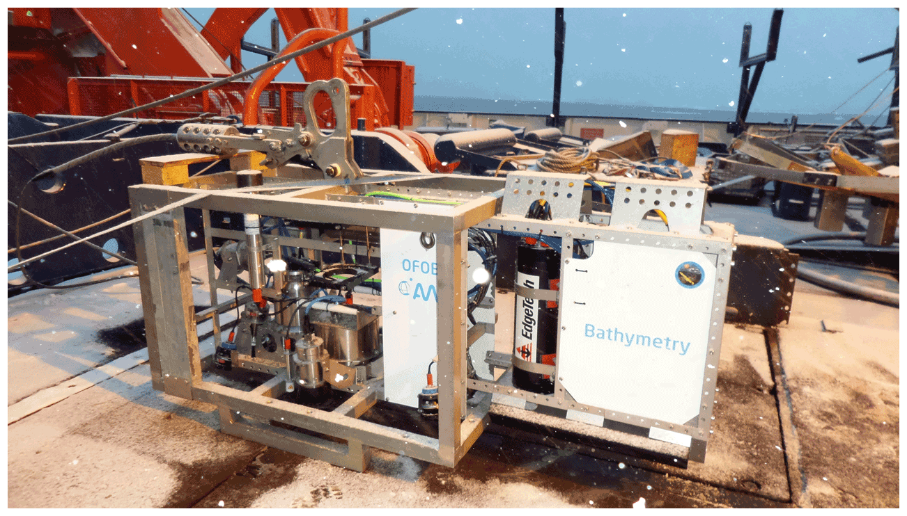
Figure 1The Ocean Floor Observation and Bathymetry System (OFOBS) of the Alfred Wegener Institute (AWI), Helmholtz Centre for Polar and Marine Research, on deck awaiting deployment during the PS124 expedition to the southern Weddell Sea (February–March 2021).
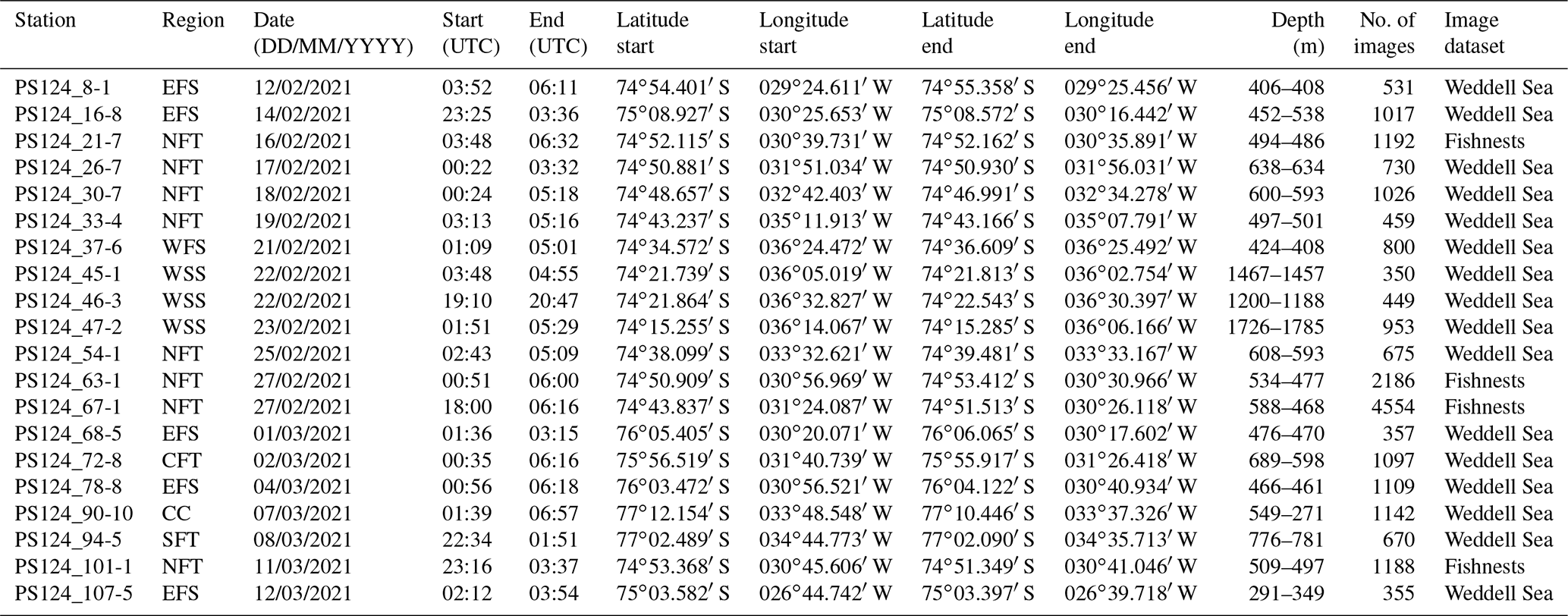
Table 1Locations of OFOBS deployments made during PS124. Start and end position coordinates and times are given in addition to the number of images collected during each deployment. Images from image dataset “Fishnests” are available at https://doi.org/10.1594/PANGAEA.932827 (Purser et al., 2021a), with images from the “Weddell Sea” dataset available at https://doi.org/10.1594/PANGAEA.936205 (Purser et al., 2021d).
In this dataset we present the seafloor still image and acoustic data collected by the OFOBS device during 20 deployments in the WS (Table 1). These data are envisioned for use in a range of scientific studies, such as the following.
-
Assessing the seafloor community structures across various contrasting regions of the Weddell Sea seafloor, including those associated with the upwelling warm waters from the deep Weddell Sea onto the continental shelf as well as the cold, downwelling waters associated with some of the shelf canyon systems.
-
Facilitating a temporal comparison of fauna to images collected during previous expeditions to the area.
-
Assisting the generation of high-resolution seafloor topographical maps of the Weddell Sea. These data are the first extended side-scan survey of many areas of the southern Weddell Sea and Filchner Trough and will likely be usefully integrated into the next iteration of the Southern Ocean bathymetric chart (Arndt et al., 2013; Dorschel et al., 2022).
-
Supporting the planning of marine protected areas (MPAs) in Antarctic waters, the data presented here are of the highest spatial resolution yet collected from the area, highlighting the high heterogeneity and high biomasses associated with some of the regions of the seafloor surveyed. Given the uniqueness of the Weddell Sea under the ice environment in general and the high biomass associated with the ice fish nesting event observed during the PS124 expedition, it is hoped that these data will support the establishment of an internationally agreed MPA as soon as possible.
2.1 OFOBS
The OFOBS is the current iteration of the towed seafloor survey device (Purser et al., 2021b) routinely deployed by the Deep-Sea Ecology and Technology group of the AWI for benthic polar research, particularly in under-ice environments (Boetius and Purser, 2017; Morganti et al., 2021; Purser et al., 2021b). The OFOBS is a benthic sled system which is towed behind a research vessel to visually and acoustically investigate the seafloor. During the PS124 expedition, the OFOBS was deployed 20 times. To ensure that the acoustic and illumination systems mounted on the OFOBS did not interfere with the activities of marine mammals, a two-person “mammal watch” was maintained on the bridge of RV Polarstern throughout each deployment, and acoustic systems (positioning, side-scan and forward-facing acoustic cameras) were only powered up ∼50 m above the seafloor. Throughout the deployments, illumination, flight heights and tow velocities were comparable to those used for the 2020 deployment in the western Weddell Sea (expedition PS118, Purser et al., 2021b). The previous towed benthic survey device used in the area, the Ocean Floor Observation System (OFOS) mounted with the same camera systems, was flown with the same illumination, flight height and tow velocities (PS86 in 2015 and PS96 in 2016, Piepenburg et al., 2017). Throughout the deployments, the latitude, longitude and depth of the OFOBS were determined via the integration of the iXBlue Posidonia ultra-short baseline (USBL) system used by RV Polarstern, localising the relative position of the OFOBS to the vessel (itself deriving its position from the ship's satellite-based global navigation satellite system, GNSS). To improve the accuracy of the system positioning for collection of smooth acoustic data, the OFOBS integrated ixBLUE inertial navigation system (INS) and dynamic velocity logger (DVL) further refined the positioning of the system. For the collected image data the Posidonia positions at the time of image collection were logged for each image. During the expedition there were occasional problems with the Posidonia system, and where there were gaps in position updates coincident with image collection, a position was estimated from the preceding and subsequent position fixes assigned. During PS124, an accuracy of the position assumed to be 0.2 % of the slanted cable tether length was estimated or for the majority of deployments made during PS124, of ∼30 m throughout. The start and end positions of each deployment are given in Table 1, with the position fix for each image provided in the data uploaded to PANGAEA.
Throughout all deployments, a still image camera, a high-resolution video camera, a forward-facing acoustic camera and a multibeam side-scan system collected data concurrently from the seafloor. Each of these systems are introduced in more detail in Sect. 2.1.1–2.1.4.
To allow visual seafloor coverage estimations to be made for the areas covered by each image or video frame, three red sizing lasers (FLEXPOINT) were mounted vertically on the OFOBS frame, pointing perpendicularly and with a 50 cm spacing (Purser et al., 2019b). For the majority of deployments during PS124, 4–6 m2 of the seafloor was imaged in each photograph. The OFOBS was generally towed at a speed of 0.5 kts at a height of 1.5–2 m above the seafloor. For stations PS124_54-1, PS124_63-1, PS124_67-1 and PS124_101-1, seafloor coverage per image was 15–25 m2, as for these deployments a higher flight altitude of 2.5–4.5 m was maintained as well as a faster towing velocity of 1.5 kts.
Throughout all deployments, illumination of the seafloor was provided by four downward-facing LED lights (SeaLight Sphere 3150) mounted on the corners of the OFOBS frame. Two additional strobe lights (iSiTEC UW-Blitz 250) were through-the-lens (TTL) triggered light sources that additionally fired when images were collected. The standard LED lights were sufficient to illuminate the seafloor for the HD video recorder also operating throughout each deployment (iSiTEC, Sony FCB-H11). For a full technical description of the OFOBS, see Purser et al. (2019b).
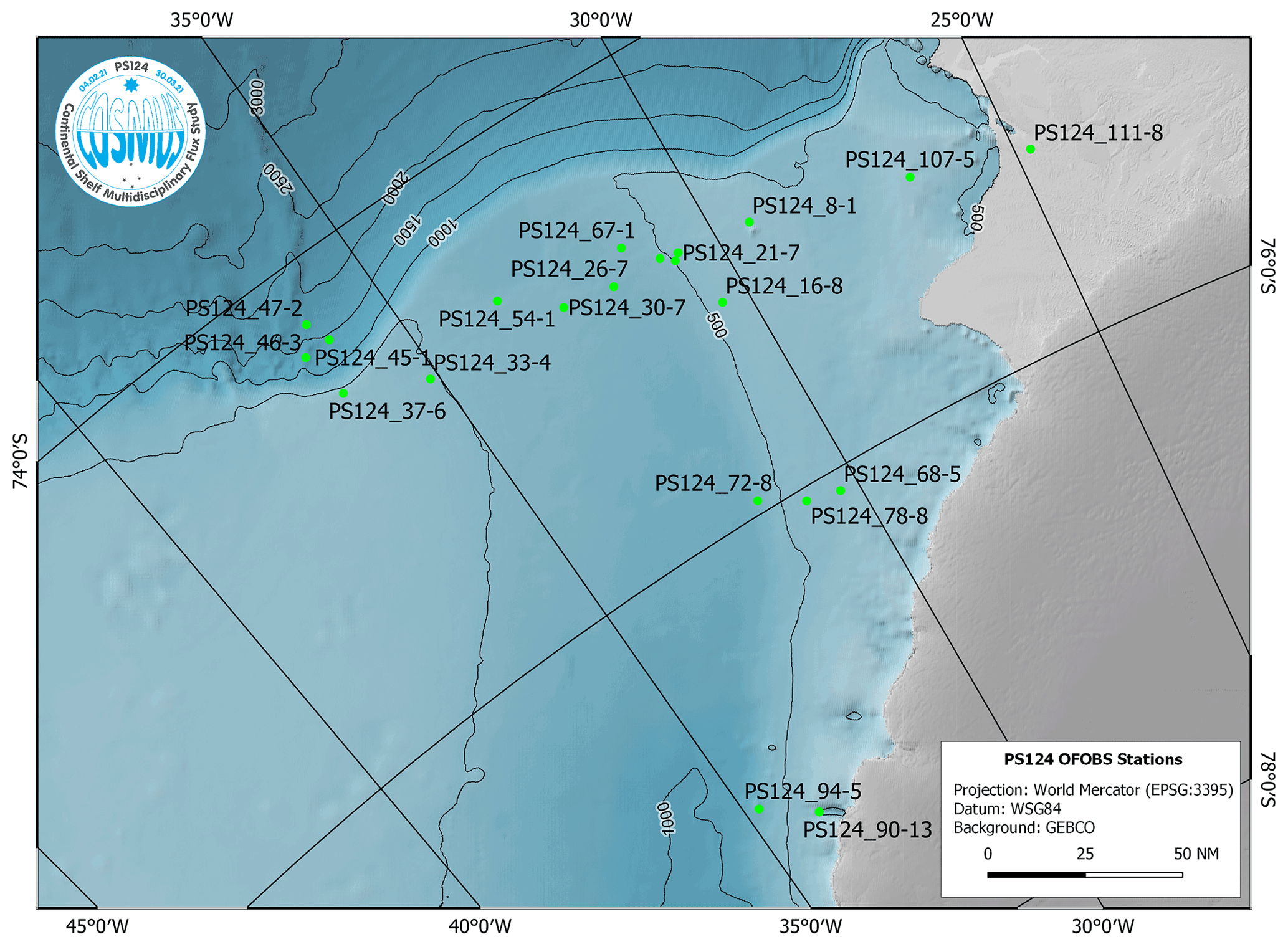
Figure 2Regional map showing the positions of OFOBS deployments made during RV Polarstern cruise PS124. Deployment PS124_111-8 was made only a few weeks after the A74 iceberg Brunt Ice Shelf calving event.
2.1.1 Still image data collection
Still images were collected with a 26-megapixel still camera system (iSiTEC, Canon EOS 5D Mark 3). Images were collected at automated 20 s intervals throughout each deployment, though additional “hotkey” images could be taken to record features of interest, such as the first observations of particular fauna, items of litter or geological features. Within the dataset, images taken by the timer were designated with the prefix “TIMER”, whereas those taken manually by the OFOBS operations team were designated with the prefix “SW_RELEASER” or “HOTKEY”. No pre-processing stages were applied to the maximum-resolution .jpeg data collected from the camera, which are provided here at the maximum acquired resolution. The data collected during PS124 complement data collected from the same stations or stations in close proximity during Antarctic cruises over the last 2 decades, as a time series survey (i.e. Piepenburg et al., 2017), and represent the first image-based surveys of some areas of the Weddell Sea, such as the area covered by an active Neopagetopsis ionah breeding colony (Purser et al., 2022).
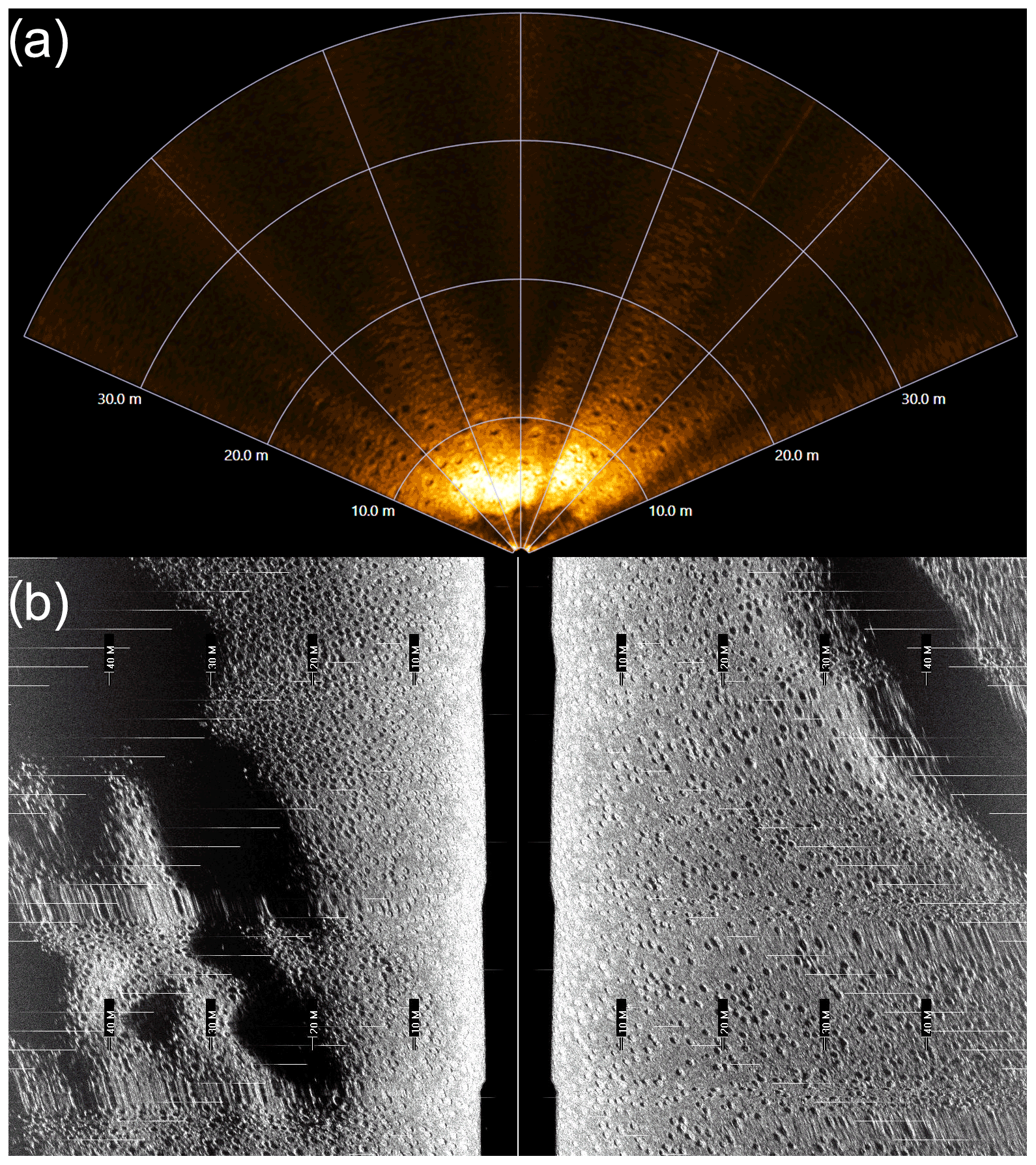
Figure 3Raw acoustic data collected by the OFOBS during deployment PS124_63-1. Data show an area of the seafloor wholly covered by an array of actively nesting ice fish. (a) Forward-facing acoustic camera. (b) High-frequency side-scan sonar data. An area of slightly undulating seafloor is wholly covered with actively nesting ice fish. The white, bright reflectors within the centre of many of the ice fish nests indicate the presence of a brooding fish.
2.1.2 Video image data collection
Throughout all deployments, HD (high-definition) video data were recorded by the OFOBS for the duration of each dive with an HD video recorder (iSiTEC, Sony FCB-H11). Unfortunately, during PS124 problems with communication with the camera resulted in fragmented video files and occasional gaps in video data collection. Despite the breakup in the video data, the collected fragments may be used for the 3D “structure from motion” reconstruction of areas of high-resolution seafloor topography, an approach which has recently been used with OFOBS data to demonstrate the movement of Arctic sponges (Morganti et al., 2021) and the interactions of deep-diving whales with the deep seafloor (Purser et al., 2019a).
2.1.3 Forward acoustic camera data collection
A forward-facing acoustic camera is mounted on the OFOBS, allowing the OFOBS operator to be aware of steep structures or a rising seafloor approaching the platform as it is towed forward through the water, allowing ample time to winch the system to a safer height. During PS124, a BlueView M900-130 acoustic camera was mounted for this purpose, mounted at a 5∘ angle from horizontal at the front of the OFOBS frame. Data are recorded routinely throughout all OFOBS deployments from this system but are often of little scientific value for benthic surveys, with more scientific work being carried out in the water column and relating to fish distributions and behaviour (Wolff and Badri-Hoeher, 2014). However, as discussed in Sect. 2.2.1 and 2.2.4, during PS124 the forward acoustic camera also collected data of scientific worth, illuminating aspects of the seafloor structure and faunal interactions not immediately apparent from still or video image data. All data collected with this sensor during PS124 are provided within this dataset.

Figure 4Typical seafloor images collected from each of the OFOBS surveys made of the Weddell Sea Shelf seafloor during RV Polarstern cruise 124. (a) Station PS124_45-1, SW-RELEASER_2021_02_22 at 04_19_03 IMG_0199.JPG, (b) Station PS124_46-3. HOTKEY_2021_02_22 at 19_24_57 IMG_0056.JPG, (c) Station PS124_47-2, TIMER_2021_02_23 at 03_15_59 IMG_0405.JPG, (d) Station PS124_47-2, TIMER_2021_02_23 at 03_14_37 IMG_0400-JPG. The three red points within each image represent the sizing lasers (50 cm spacing). Red arrows in panel (b) indicate the positions of these three red points. All images are presented here and in the dataset, with no manipulation or colour correction.
2.1.4 Side-scan data collection and bathymetric map production
The side-scan bathymetry sonar mounted on the OFOBS was an interferometric EdgeTech 2205 AUV/ROV MPES (multiphase echosounder) with two side-scan frequencies (low/LF: 230 kHz and high/HF: 540 kHz). Both frequencies operate in parallel. Integrated into the transducers were receive arrays to allow calculation of 2.5D data per ping (3.5 Hz for LF, 7 Hz for HF). On collection, the OFOBS operators could inspect the raw data via a waterfall response display on the ship (Fig. 3b).
Data were collected and recorded as both raw data and stave data (Bjørnø, 2017). These data can then be used, in combination with the OFOBS positioning information, to generate 10 and 20 cm resolution topographic maps of the swathes of the seafloor passed over by the OFOBS during deployments. The low deployment height of the side-scan system allows small surface depressions and features of a height of a few tens of centimetres to be visible in the derived mapping products to elucidate aspects of the seafloor structure and fauna interactions with the seafloor at a high resolution (Purser et al., 2019a; Marsh et al., 2018). Maps at 10 and 20 cm resolution have been produced for all station deployments and form part of this dataset.
2.1.5 Weddell Sea slope
Three OFOBS deployments were made on the Weddell Sea slope (WSS) (Table 1, Fig. 2), deployments PS124_45-1, PS124_46-3 and PS124_47-2. Deployments were made at several depths from 1188 to 1785 m on the continental slope running from near the Filchner Shelf edge in the south downward toward the north. All deployments were made 5–10 nm east of a ridge structure (Fig. 2). Throughout the deployments clear ripple structures were abundantly clear within many still seafloor images (Fig. 4a–d). A complex interaction between flow regimes in direction and flow velocities is recorded in the pattern of cross-cutting ripple structures, seeming to indicate changing prevalent flow directions over time (Fig. 4d). Some areas of the seafloor consisted of gravel and occasional small pebbles, poorly sorted, though these were often overlaid with finer sediments with clear rippling and probably migrating finer sediment deposits, also indicating a temporal variability in flow velocities (Fig. 4a). Occasional areas of the seafloor showed no clear flow structures, with a fine sediment structure and clear indications of fauna reworking the sediments with surface expressions of burrows clearly visible, such as those occupied by shrimp in Fig. 4b. The intermixed rippled beds and occasional larger, angular grit provided physical traps within which or onto which fibrous transported material carried by currents from the shelf and settling through the water column had become entrapped (Fig. 4a and d) as a potential food source for benthic fauna (Jansen et al., 2018). This entrapped material was associated with higher ophiuroid (Fig. 4a) or urchin (Fig. 4d) abundances. The forward-facing acoustic camera data and the side-scan data collected from the shelf illuminate the larger sedimentary structures across this region clearly.
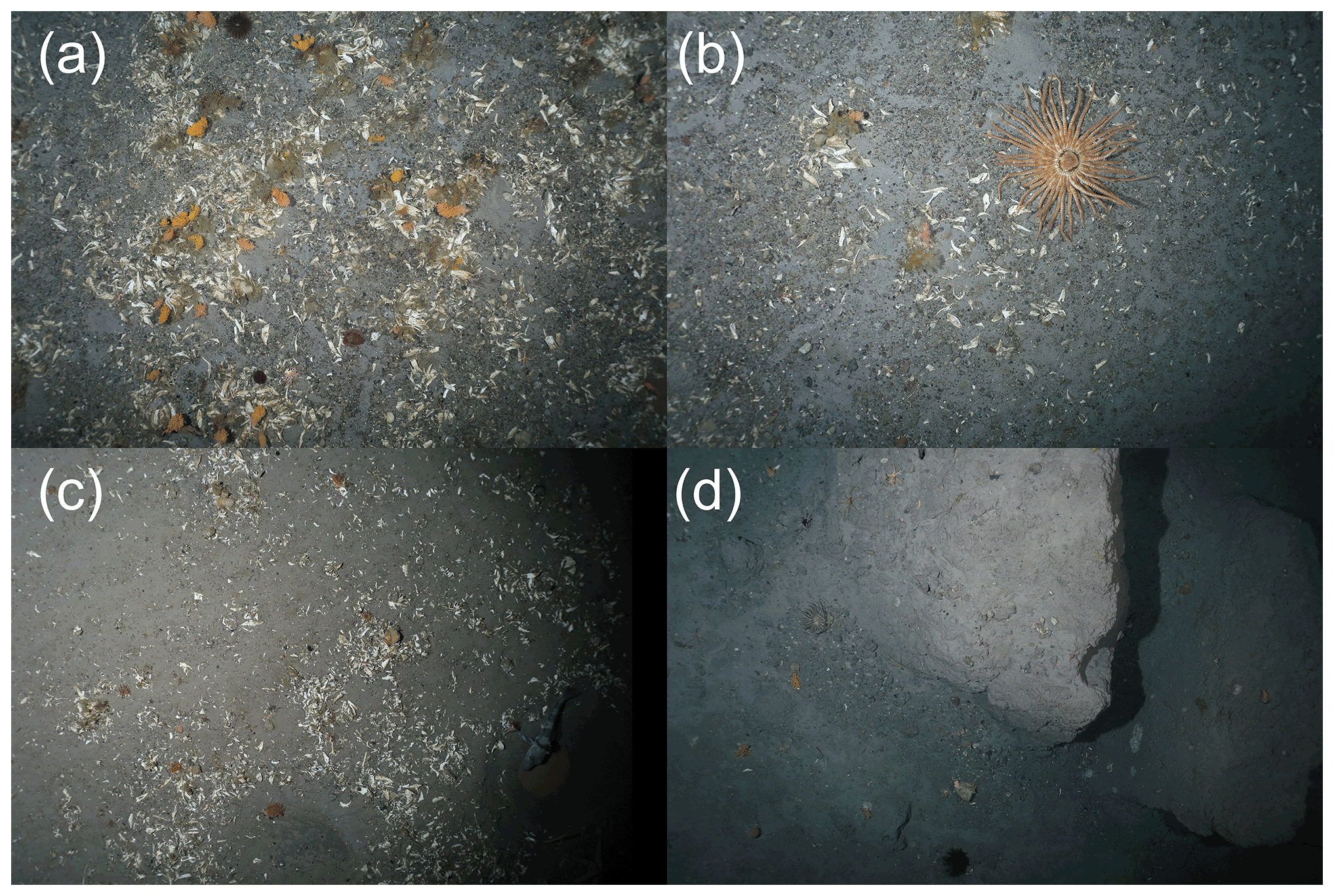
Figure 5Typical seafloor images collected from each of the OFOBS surveys made of the western Filchner Shelf seafloor during RV Polarstern cruise 124. All images were taken during deployment PS124_37-6. (a) SW_RELEASER_2021_02_21 at 01_36_51 IMG_0127.JPG, (b) SW_RELEASER_2021_02_21 at 01_37_28 IMG_0130-JPG, (c) SW_RELEASER_2021_02_21 at 02_44_44 IMG_0336.JPG, (d) SW_RELEASER_2021_02_21 at 03_56_56 IMG_0579.JPG. The three red points within each image represent the sizing lasers (50 cm spacing). All images are presented here and in the dataset with no manipulation or colour correction.
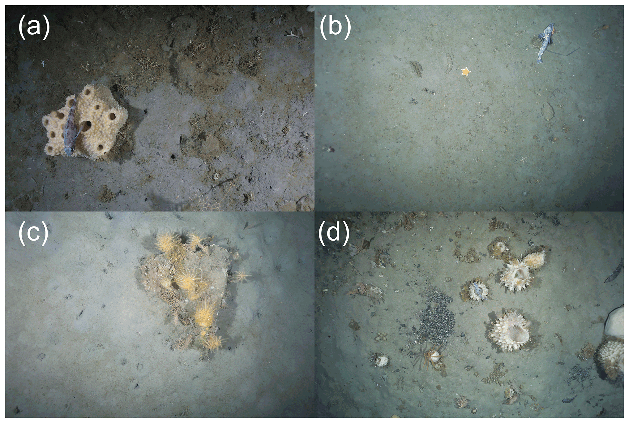
Figure 6Typical seafloor images collected from each of the OFOBS surveys made of the eastern Filchner Shelf seafloor during RV Polarstern cruise 124. (a) Station PS124_8_1, HOTKEY_2021_02_12 at 04_27_23 IMG_0081.JPG, (b) Station PS124_16-08, HOTKEY_2021_02_15 at 01_40_22 IMG_0567.JPG, (c) Station PS124_68-5, TIMER_2021_03_01 at 02_19_28.IMG, (d) Station PS124_107-05, TIMER_2021_03_12 at 02_17_42 IMG_0032.JG. The three red points within each image represent the sizing lasers (50 cm spacing). All images are presented here and in the dataset with no manipulation or colour correction.
2.1.6 Western Filchner Shelf
One OFOBS deployment was made on the western Filchner Shelf (WFS) (Table 1, Fig. 2), deployment PS124_37-6. This station, 20 nm south of the shallowest, northernmost station surveyed on the Weddell Sea shelf (see Sect. 2.2.1), was quite distinctive in seafloor appearance. The great majority of images collected from the seafloor showed a flat seafloor surface scattered with very many dead barnacle remains (Fig. 5a–c). Where accumulations of fragments were highest, epifauna establishment on these biogenic hard surfaces was not uncommon, with soft corals (Fig. 5a) and sponges (Fig. 5c) both utilising this habitat niche resource, closely resembling the outer slope community described for the region (Pineda-Metz et al., 2019). Mobile fauna, such as octopi and crinoids (Fig. 5a), starfish (Fig. 5b) and fish (Fig. 5c), were observed amongst the fragments. Very occasionally, circular fish nest depressions were observed, though these were far less abundant than observed in the northern Filchner Trough station data (see Sect. 2.2.4), and no eggs were observed. Several iceberg-scoured areas were covered by the OFOBS transect (Fig. 5d).
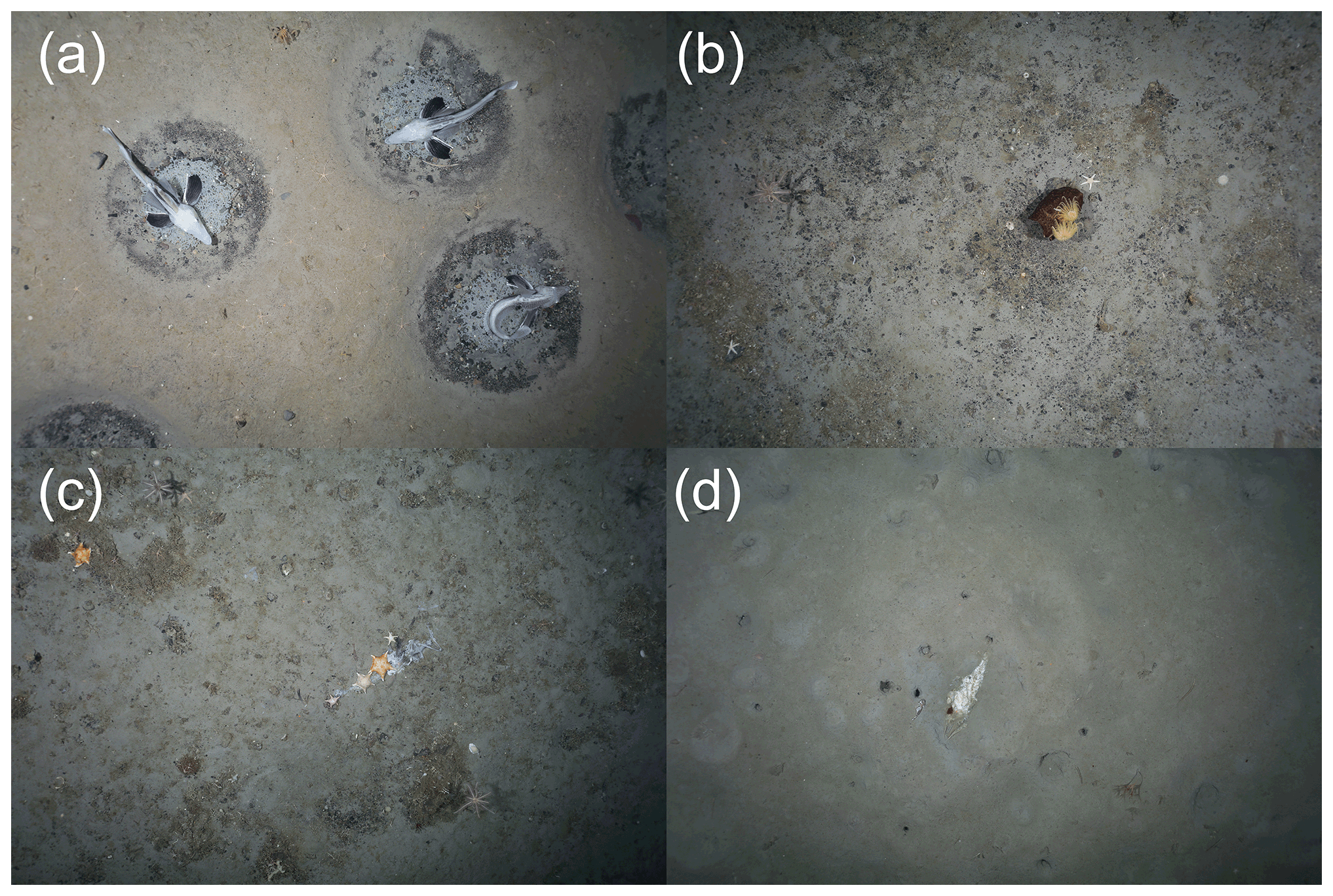
Figure 7Typical seafloor images collected from each of the OFOBS surveys made of the northern Filchner Trough seafloor during RV Polarstern cruise 124. (a) Station PS124_21-7, HOTKEY_2021_02_16 at 04_05_34 IMG_0112.JPG, (b) Station PS124_26-07, TIMER_2021_02_17 at 00_43_30 IMG_0124.JPG, (c) Station 30-07, SW_RELEASER_2021_02_18 at 03_26_43 IMG_0667.JPG, (d) Station PS124_33-04, SW_RELEASER_2021_02_19 at 03_55_18 IMG_0162.JPG. The three red points within each image represent the sizing lasers (50 cm spacing). All images are presented here and in the dataset with no manipulation or colour correction.
2.1.7 Eastern Filchner Shelf
Four OFOBS deployments were made on the eastern Filchner Shelf (EFS) (Table 1, Fig. 2), deployments PS124_8-1, PS124_16-8, PS124_78-8 and PS124_107-5. The eastern Filchner shelf differed greatly from the western shelf (Sect. 2.2.2), with no barnacle fragments evident and a much softer, heavily bioturbated seafloor common across much of the seafloor area surveyed. From side-scan and forward-facing sonar data, occasional fish nest structures seemed to be present occasionally on the seafloor, though these were not clear from the camera data. Occasional drop stones or areas of grit visible at the ocean–seafloor interface (potentially associated with a fish nest formation, Fig. 6d) facilitated colonisation by a diverse sponge community (Fig. 6a, c and d), despite the generally soft sediment composition of the seafloor. These sponges and larger drop stone features were commonly utilised by fish (Fig. 6a and d) and crinoids (Fig. 6c and d) as points of increased elevation. Primary production detritus was observed entrapped within this seafloor structure and sponge spicules (Fig. 6a and d), material likely providing nutrient input for the diverse range of further filter-feeding fauna present across the region, including anemones (Fig. 6d), soft corals (Fig. 6c and d) and bryozoans (Fig. 6a) resembling the eastern shelf community (Pineda-Metz et al., 2019). Deposit feeding fauna typical for the Filchner Trough community (Pineda-Metz et al., 2019), such as holothurians (Fig. 6b), and scavengers such as starfish were also observed (Fig. 6b). Dead ice fish, often with a community of scavenging fauna, were observed at Station 16-8, the station in closest proximity to the active ice fish breeding community observed in the northern Filchner Trough survey area (Sect. 2.2.4, Fig. 6b).
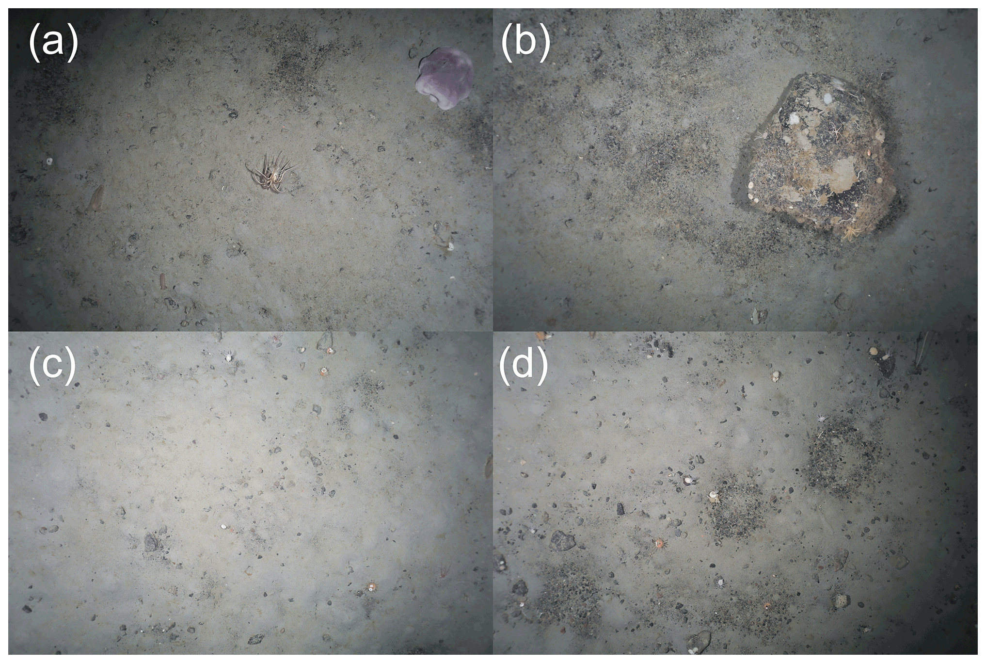
Figure 8Typical seafloor images collected from each of the OFOBS surveys made of the central Filchner Trough seafloor during RV Polarstern cruise 124. All images were taken at Station PS124_72-08. (a) SW_RELEASER_2021_03_02 at 00_48_38 IMG_0091.JPG, (b) SW_RELEASER_2021_03_02 at 01_08_57 IMG_0159.JPG, (c) TIMER_2021_03_02 at 03_44_06 IMG_0650.JPG, (d) SW_RELEASER_2021_03_02 at 04_08_38 IMG_0726-IMG. The three red points within each image represent the sizing lasers (50 cm spacing). All images are presented here and in the dataset with no manipulation or colour correction.
2.1.8 Northern Filchner Trough
Eight OFOBS deployments were made across the northern Filchner Trough (NFT) (Table 1, Fig. 2), deployments PS124_27-1, PS124_26-7, PS124_30-7, PS124_33-4, PS124_54-1, PS124_63-1, PS124_67-1 and PS124_101-1. This region was the most heavily surveyed during PS124, following the discovery of the ice fish breeding colony described in Purser et al. (2022) (Fig. 7a). This region covered both the trough floor, which was primarily associated with a sill structure marking the intersection of the Filchner Trough with the Weddell Sea as well as the sloped flanks of the trough running up to the western and eastern Filchner Shelf regions (see Sect. 2.2.2 and 2.2.3 above). Across the entire northern Filchner Trough survey area, which primarily covered the Filchner sill and the eastern flank of the northern section of the Filchner Trough, fish nest forms were abundantly clear from side-scan and forward-facing acoustic camera data (Fig. 3). Nest forms across the active breeding colony area were immediately apparent within the still image data (Fig. 7a), whereas elsewhere the forms were less distinct in the images, appearing older and degraded (Fig. 7b and c) or within much softer sediments and at a lower nest density (Fig. 6d). Dead ice fish carcasses were occasionally visible across the region, often undergoing active scavenging (Fig. 7c and d). Aside from within the active breeding colony, no living ice fish or fish eggs were observed across the area within any of the nest forms, though bryozoans, soft corals and sponges (Fig. 7b) had colonised some of the seafloor depressions observed, resembling a mix between the eastern shelf and outer slope communities of the Filchner region (Pineda-Metz et al., 2019).
2.1.9 Central Filchner Trough
One OFOBS deployment was made on the central Filchner Trough (CFT) (Table 1, Fig. 2), deployment PS124_72-8. Deployed at depths comparable to the active fish breeding colony observed with the northern Filchner Trough survey area (Sect. 2.2.4), no active fish nests were observed in the area, though nest forms were occasionally observed (Fig. 8d). In general, the sediments observed across this deployment were softer, with less detritus visible than further north. A megafauna community similar to the trough community was observed (Pineda-Metz et al., 2019), with occasional large octopi also observed and further holothurian species (Fig. 8a).
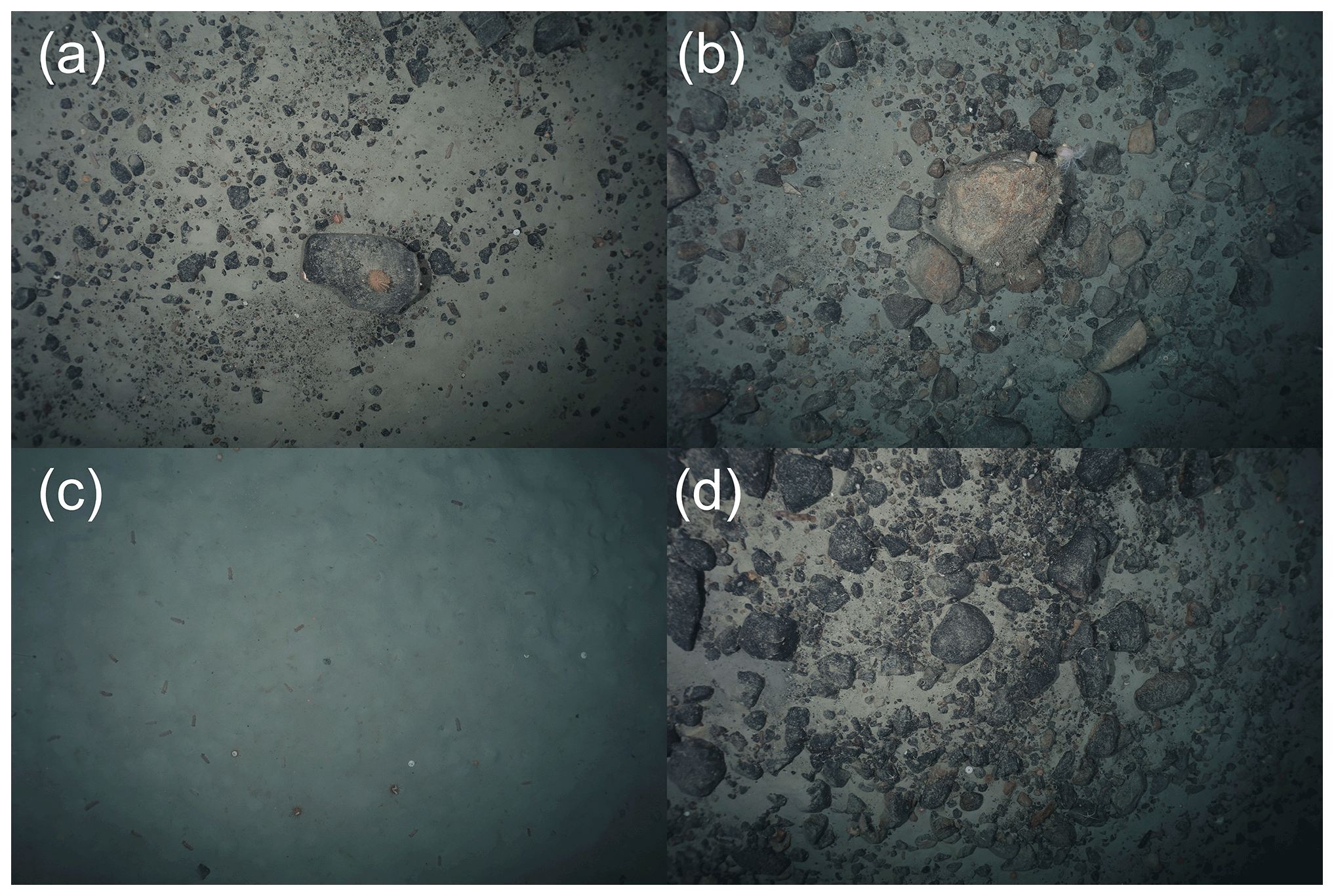
Figure 9Typical seafloor images collected from each of the OFOBS surveys made of the southern Filchner Trough seafloor during RV Polarstern cruise 124. All images were taken during deployment Station PS124_94-5. (a) SW_RELEASER_2021_03_07 at 23_03_46 IMG_0115.JPG, (b) SW_RELEASER_2021_03_08 at 00_31_37-JPG, (c) TIMER_2021_03_07 at 23_29_54 IMG_0207.JPG, (d) TIMER_2021_03_07 at 23_30_14 IMG_0209-JPG. The three red points within each image represent the sizing lasers (50 cm spacing). All images are presented here and in the dataset with no manipulation or colour correction.
2.1.10 Southern Filchner Trough
One OFOBS deployment was made on the southern Filchner Trough (SFT) (Table 1, Fig. 2), deployment PS124_94-5. Across this deployment, the Filchner Trough was observed to be generally far more abundant in rock and drop stone abundance (Fig. 9a, b and d), though this generally rocky area was occasionally crossed by areas of 100 % soft sediment coverage. A differing faunal community was observed here than elsewhere in the Filchner Trough, with a lower population of hard substrates with filter-feeding or encrusting fauna (Fig. 9b) and high abundances of holothurians across the softer sediment areas (Fig. 9c), typical for the Filchner Trough community (Pineda-Metz et al., 2019).
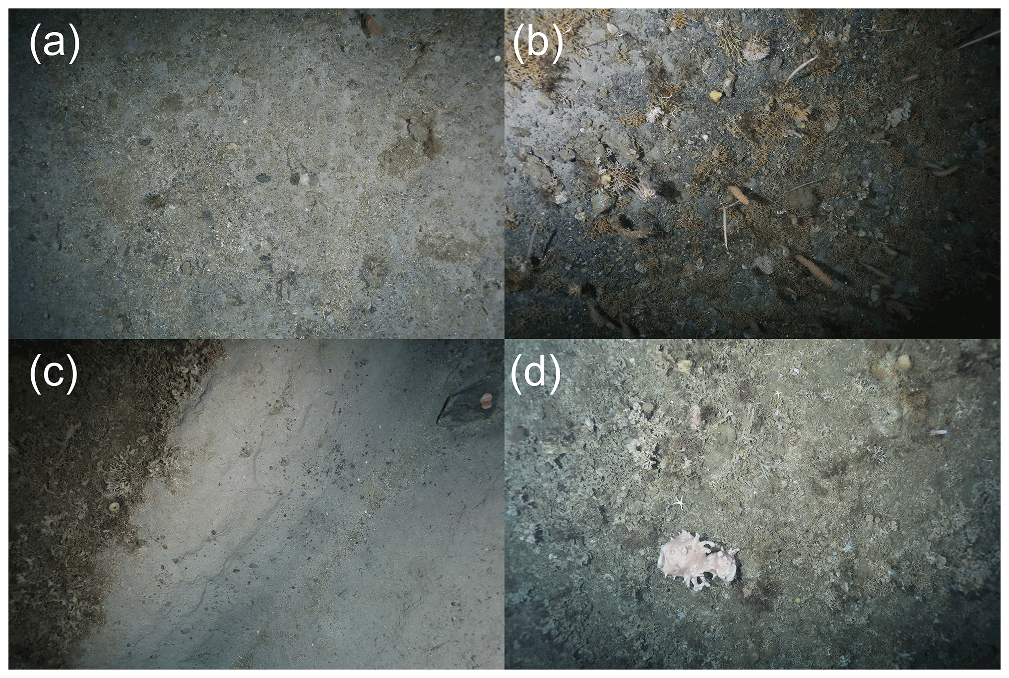
Figure 10Typical seafloor images collected from each of the OFOBS surveys made of the coastal canyon seafloor during RV Polarstern cruise 124. All images were taken during deployment Station 90-13. (a) TIMER_2021_03_07 at 01_48_12 IMG_0078.JPG, (b) TIME_2021_03_07 at 02_48_47 IMG_0305.JPG, (c) SW_RELEASER_2021_03_07 at 03_31_08 IMG_0453.JPG, (d) SW_RELEASER_2021_03_07 at 04_50_44 IMG_0716.JPG. The three red points within each image represent the sizing lasers (50 cm spacing). All images are presented here and in the dataset with no manipulation or colour correction.
2.1.11 Coastal canyon
One OFOBS deployment was made across a coastal canyon feature (Albert Trough – Hodgson et al., 2018) to the southern extent of the cruise survey area (CC) (Table 1, Fig. 2), deployment PS124_90-13. The southernmost OFOBS deployment made during PS124 cut across an east–west-trending canyon running from the Antarctic coast onto the shelf. Under an area occasionally free of sea ice, within the polynya formed as sea ice and shelf ice fragments carried in a westerly direction, the seafloor was abundant with life and exhibited a complex mix of topographies. Much of the seafloor was comprised of gravel, intermittent drop stones and intermixed softer sediments (Fig. 10a). In areas with larger pebbles in evidence, much of the seafloor was colonised by dense growths of soft corals, sponges and bryozoans (Fig. 10b and d and upper left, Fig. 10c), resembling the southern shelf community (Pineda-Metz et al., 2019). Situated so close to the Antarctic coast and ice sheets, seafloor iceberg scouring was abundant across the station (Fig. 10c), with contrasting degrees of seafloor recolonisation evident (Gutt, 2001).
All seafloor images collected with the OFOBS system are available from the PANGAEA data publisher. No preprocessing or processing stages were applied prior to upload, with no colour correction or light-vignetting algorithms applied. These images are provided with georeferenced positions for each image, as derived from the Posidonia system (https://doi.org/10.1594/PANGAEA.936205 (Purser et al., 2021d) and https://doi.org/10.1594/PANGAEA.932827 (Purser et al., 2021a) as indicated in Table 1). Acoustic data for all deployments are also available from PANGAEA, with the raw side-scan data available at https://doi.org/10.1594/PANGAEA.939322 (Hehemann et al., 2021b) and forward-facing acoustic camera data at https://doi.org/10.1594/PANGAEA.939341 (Purser et al., 2021c). Seafloor topographic maps derived from the side-scan data are available at https://doi.org/10.1594/PANGAEA.939087 (Hehemann et al., 2021a).
The datasets are published under the Creative Commons Attribution 4.0 International (CC BY 4.0) licence. Video data collected via the OFOBS system are available from the authors on request.
AP ran the OFOBS throughout the expedition and planned seafloor deployments with MH, FW, LH, LB and EW, with the exception of deployment PS124_90-13, which was run by LB. AP and LB ran and processed the OFOBS imaging systems. LH, LB and EW ran and processed the OFOBS acoustic systems. AN provided technical maintenance for OFOBS and deployed the device with the assistance of Polarstern crew on deck. LV ensured appropriate mammal watches were maintained throughout all deployments. SEAPM provided fauna support and placed the image data in the context of previous cruises to the region and current Weddell Sea seafloor habitat categorisation schemes. The benthic science planning for the cruise was coordinated by MH. FW was group leader for benthic imaging. AP wrote the manuscript, with input from SEAPM and additional contributions from all the other co-authors.
The contact author has declared that none of the authors has any competing interests.
Publisher's note: Copernicus Publications remains neutral with regard to jurisdictional claims in published maps and institutional affiliations.
The captain, crew and scientific party of RV Polarstern expedition PS124 are thanked for their enthusiastic support and interest during this cruise, made during the second year of the global COVID-19 pandemic. The complexities of conducting research in Antarctica during the global pandemic were smoothed by the AWI logistics and ship co-ordination teams. Steffen Hain is thanked for assisting in ensuring we fulfilled our environmental commitments and commitment to the Antarctic Treaty during the expedition. Ulrich Hoge is thanked for onshore support of the OFOBS system. Stefanie Schumacher and Janine Felden from the PANGAEA team are thanked for their helpful and efficient work in uploading these data to archive. The following AWI grant numbers are appreciated for supporting the work incorporated into this dataset: AWI_PS124_02, AWI_PS124_03, AWI_PS124_05 and AWI_PS124_06.
This research has been supported by the Alfred Wegener Institute Helmholtz Centre for Polar and Marine Research (grant nos. AWI_PS124_02, AWI_PS124_03, AWI_PS124_05 and AWI_PS124_06).
This paper was edited by Giuseppe M. R. Manzella and reviewed by Robert Larter and one anonymous referee.
Arndt, J. E., Schenke, H. W., Jakobsson, M., Nitsche, F. O., Buys, G., Goleby, B., Rebesco, M., Bohoyo, F., Hong, J., Black, J., Greku, R., Udintsev, G., Barrios, F., Reynoso-Peralta, W., Taisei, M., and Wigley, R.: The International Bathymetric Chart of the Southern Ocean (IBCSO) Version 1.0 – A new bathymetric compilation covering circum-Antarctic waters, Geophys. Res. Lett., 40, 3111–3117, https://doi.org/10.1002/grl.50413, 2013.
Bjørnø, L.: Chapter 10 – Sonar Systems, in: Applied Underwater Acoustics, edited by: Neighbors, T. H. and Bradley, D., Elsevier, 587–742, https://doi.org/10.1016/B978-0-12-811240-3.00010-2, 2017.
Boetius, A. and Purser, A.: The Expedition PS101 of the Research Vessel POLARSTERN to the Arctic Ocean in 2016, Alfred-Wegener-Institut, Helmholtz-Zentrum für Polar- und Meeresforschung, Bremerhaven, Germany, 230 pp., https://doi.org/10.2312/BzPM_0706_2017, 2017.
Dorschel, B., Hehemann, L., Viquerat, S., Warnke, F., Dreutter, S., Tenberge, Y. S., Accettella, D., An, L., Barrios, F., Bazhenova, E., Black, J., Bohoyo, F., Davey, C., De Santis, L., Dotti, C. E., Fremand, A. C., Fretwell, P. T., Gales, J. A., Gao, J., Gasperini, L., Greenbaum, J. S., Jencks, J. H., Hogan, K., Hong, J. K., Jakobsson, M., Jensen, L., Kool, J., Larin, S., Larter, R. D., Leitchenkov, G., Loubrieu, B., Mackay, K., Mayer, L., Millan, R., Morlighem, M., Navidad, F., Nitsche, F. O., Nogi, Y., Pertuisot, C., Post, A. L., Pritchard, H. D., Purser, A., Rebesco, M., Rignot, E., Roberts, J. L., Rovere, M., Ryzhov, I., Sauli, C., Schmitt, T., Silvano, A., Smith, J., Snaith, H., Tate, A. J., Tinto, K., Vandenbossche, P., Weatherall, P., Wintersteller, P., Yang, C., Zhang, T., and Arndt, J. E.: The International Bathymetric Chart of the Southern Ocean Version 2, Sci. Data, 9, 275, https://doi.org/10.1038/s41597-022-01366-7, 2022.
Gerdes, D.: Antarctic trials of the multi-box corer, a new device for benthos sampling, Polar Record, 26, 35–38, https://doi.org/10.1017/S0032247400022749, 1990.
Gutt, J.: On the direct impact of ice on marine benthic communities, a review, Polar Biol., 24, 553–564, https://doi.org/10.1007/s003000100262, 2001.
Hattermann, T., Nicholls, K. W., Hellmer, H. H., Davis, P. E. D., Janout, M. A., Østerhus, S., Schlosser, E., Rohardt, G., and Kanzow, T.: Observed interannual changes beneath Filchner-Ronne Ice Shelf linked to large-scale atmospheric circulation, Nat. Commun., 12, 2961, https://doi.org/10.1038/s41467-021-23131-x, 2021.
Hehemann, L., Boehringer, L., Purser, A., Werner, E., and Wenzhöfer, F.: Seafloor bathymetric maps derived from side scan data collected along OFOBS profiles during POLARSTERN cruise PS124 to the southern Weddell Sea, PANGAEA [data set], https://doi.org/10.1594/PANGAEA.939087, 2021a.
Hehemann, L., Purser, A., Boehringer, L., Werner, E., and Wenzhöfer, F.: Side scan sonar and swath bathymetry collected along OFOBS profiles during POLARSTERN cruise PS124, PANGAEA [data set], https://doi.org/10.1594/PANGAEA.939322, 2021b.
Hellmer, H. H. and Holtappels, M.: The Expedition PS124 of the Research Vessel POLARSTERN to the southern Weddell Sea in 2021, Alfred Wegener Institute for Polar and Marine Research, Bremerhaven, 237 pp., https://doi.org/10.48433/BzPM_0755_2021, 2021.
Hodgson, D. A., Hogan, K., Smith, J. M., Smith, J. A., Hillenbrand, C.-D., Graham, A. G. C., Fretwell, P., Allen, C., Peck, V., Arndt, J.-E., Dorschel, B., Hübscher, C., Smith, A. M., and Larter, R.: Deglaciation and future stability of the Coats Land ice margin, Antarctica, The Cryosphere, 12, 2383–2399, https://doi.org/10.5194/tc-12-2383-2018, 2018.
Jaffe, J.: Underwater Optical Imaging: The Past, the Present, and the Prospects, Oceanic Engineering, IEEE Journal of, 40, 683–700, https://doi.org/10.1109/JOE.2014.2350751, 2015.
Janout, M. A., Hellmer, H. H., Hattermann, T., Huhn, O., Sültenfuss, J., Østerhus, S., Stulic, L., Ryan, S., Schröder, M., and Kanzow, T.: FRIS Revisited in 2018: On the Circulation and Water Masses at the Filchner and Ronne Ice Shelves in the Southern Weddell Sea, J. Geophys. Res.-Oceans, 126, e2021JC017269, https://doi.org/10.1029/2021JC017269, 2021.
Jansen, J., Hill, N. A., Dunstan, P. K., McKinlay, J., Sumner, M. D., Post, A. L., Eleaume, M. P., Armand, L. K., Warnock, J. P., Galton-Fenzi, B. K., and Johnson, C. R.: Abundance and richness of key Antarctic seafloor fauna correlates with modelled food availability, Nat. Ecol. Evol., 2, 71–80, https://doi.org/10.1038/s41559-017-0392-3, 2018.
Knust, R.: Polar Research and Supply Vessel POLARSTERN Operated by the Alfred-Wegener-Institute, Journal of large-scale research facilities JLSRF, 3, 119, https://doi.org/10.17815/jlsrf-3-163, 2017.
Marsh, L., Huvenne, V. A. I., and Jones, D. O. B.: Geomorphological evidence of large vertebrates interacting with the seafloor at abyssal depths in a region designated for deep-sea mining, R. Soc. Open Sci., 5, 180286, https://doi.org/10.1098/rsos.180286, 2018.
Morganti, T. M., Purser, A., Rapp, H. T., German, C. R., Jakuba, M. V., Hehemann, L., Blendl, J., Slaby, B. M., and Boetius, A.: In situ observation of sponge trails suggests common sponge locomotion in the deep central Arctic, Curr. Biol., 31, R368–R370, https://doi.org/10.1016/j.cub.2021.03.014, 2021.
Piepenburg, D., Buschmann, A., Driemel, A., Grobe, H., Gutt, J., Schumacher, S., Segelken-Voigt, A., and Sieger, R.: Seabed images from Southern Ocean shelf regions off the northern Antarctic Peninsula and in the southeastern Weddell Sea, Earth Syst. Sci. Data, 9, 461–469, https://doi.org/10.5194/essd-9-461-2017, 2017.
Pineda-Metz, S. E. A. and Gerdes, D.: Seabed images versus corer sampling: a comparison of two quantitative approaches for the analysis of marine benthic communities in the southern Weddell Sea (Southern Ocean), Polar Biol., 41, 515–526, https://doi.org/10.1007/s00300-017-2211-3, 2018.
Pineda-Metz, S. E. A., Isla, E., and Gerdes, D.: Benthic communities of the Filchner Region (Weddell Sea, Antarctica), Marine Ecol. Prog. Ser., 628, 37–54, https://doi.org/10.3354/meps13093, 2019.
Purser, A., Herr, H., Dreutter, S., Dorschel, B., Glud, R. N., Hehemann, L., Hoge, U., Jamieson, A. J., Linley, T. D., Stewart, H. A., and Wenzhoefer, F.: Depression chains in seafloor of contrasting morphology, Atacama Trench margin: a comment on Marsh et al. (2018), R. Soc. Open Sci., 6, 182053, https://doi.org/10.1098/rsos.182053, 2019a.
Purser, A., Marcon, Y., Dreutter, S., Hoge, U., Sablotny, B., Hehemann, L., Lemburg, J., Dorschel, B., Biebow, H., and Boetius, A.: Ocean Floor Observation and Bathymetry System (OFOBS): A New Towed Camera/Sonar System for Deep-Sea Habitat Surveys, IEEE J. Ocean. Eng., 44, 87–99, https://doi.org/10.1109/JOE.2018.2794095, 2019b.
Purser, A., Boehringer, L., Hehemann, L., and Wenzhöfer, F.: Ocean Floor Observation and Bathymetry System (OFOBS) images of Neopagetopsis ionah ice fish nest arrays in the Filchner Trough, Antarctica collected during the PS124 Polarstern expedition, PANGAEA [data set], https://doi.org/10.1594/PANGAEA.932827, 2021a.
Purser, A., Dreutter, S., Griffiths, H., Hehemann, L., Jerosch, K., Nordhausen, A., Piepenburg, D., Richter, C., Schröder, H., and Dorschel, B.: Seabed video and still images from the northern Weddell Sea and the western flanks of the Powell Basin, Earth Syst. Sci. Data, 13, 609–615, https://doi.org/10.5194/essd-13-609-2021, 2021b.
Purser, A., Hehemann, L., Boehringer, L., Werner, E., and Wenzhöfer, F.: Forward facing acoustic camera seafloor sonar data from the southern Weddell Sea, collected during POLARSTERN cruise PS124, PANGAEA [data set], https://doi.org/10.1594/PANGAEA.939341, 2021c.
Purser, A., Hehemann, L., Boehringer, L., Werner, E., and Wenzhöfer, F.: Ocean Floor Observation and Bathymetry System (OFOBS) seafloor images of the Weddell Sea, Antarctica collected during the PS124 Polarstern expedition, PANGAEA [data set], https://doi.org/10.1594/PANGAEA.936205, 2021d.
Purser, A., Hehemann, L., Boehringer, L., Tippenhauer, S., Wege, M., Bornemann, H., Pineda-Metz, S. E. A., Flintrop, C. M., Koch, F., Hellmer, H. H., Burkhardt-Holm, P., Janout, M., Werner, E., Glemser, B., Balaguer, J., Rogge, A., Holtappels, M., and Wenzhoefer, F.: A vast icefish breeding colony discovered in the Antarctic, Current Biology, 32, 842-850.e4, https://doi.org/10.1016/j.cub.2021.12.022, 2022.
Schoening, T., Purser, A., Langenkämper, D., Suck, I., Taylor, J., Cuvelier, D., Lins, L., Simon-Lledó, E., Marcon, Y., Jones, D. O. B., Nattkemper, T., Köser, K., Zurowietz, M., Greinert, J., and Gomes-Pereira, J.: Megafauna community assessment of polymetallic-nodule fields with cameras: platform and methodology comparison, Biogeosciences, 17, 3115–3133, https://doi.org/10.5194/bg-17-3115-2020, 2020.
Wolff, L. M. and Badri-Hoeher, S.: Imaging sonar-based fish detection in shallow waters, in: 2014 Oceans – St. John's, 2014 Oceans – St. John's, 1–6, https://doi.org/10.1109/OCEANS.2014.7003213, 2014.