the Creative Commons Attribution 4.0 License.
the Creative Commons Attribution 4.0 License.
 | 04 Apr 2022
Last interglacial sea-level proxies in the glaciated Northern Hemisphere
Jan Mangerud
Per Möller
Juha P. Lunkka
Valery Astakhov
Because global sea level during the last interglacial (LIG; 130–115 ka) was higher than today, the LIG is a useful approximate analogue for improving predictions of future sea-level rise. Here, we synthesize sea-level proxies for the LIG in the glaciated Northern Hemisphere for inclusion in the World Atlas of Last Interglacial Shorelines (WALIS) database. We describe 82 sites from Russia, northern Europe, Greenland and North America from a variety of settings, including boreholes, riverbank exposures and along coastal cliffs. Marine sediments at these sites were constrained to the LIG using a variety of radiometric methods (radiocarbon, uranium–thorium, potassium–argon), non-radiometric methods (amino acid dating, luminescence methods, electron spin resonance, tephrochronology) as well as various stratigraphic and palaeo-environmental approaches. In general, the sites reported in this paper do not offer constraint on the global LIG highstand, but rather evidence of glacial isostatic adjustment (GIA)-influenced sea-level positions following the Marine Isotope Stage 6 glaciation (MIS 6; 191–130 ka). Most of the proxies suggest that sea level was much higher during the LIG than at the present time. Moreover, many of the sites show evidence of regression due to sea-level fall (owing to glacial isostatic uplift), and some also show fluctuations that may reflect regrowth of continental ice or increased influence of the global sea-level signal. In addition to documenting LIG sea-level sites in a large swath of the Northern Hemisphere, this compilation is highly relevant for reconstructing the size of MIS 6 ice sheets through GIA modelling. The database is available at https://doi.org/10.5281/zenodo.5602212 (Dalton et al., 2021).
- Article
(24753 KB) - Full-text XML
- BibTeX
- EndNote


During the last interglacial (LIG), between 130 and 115 ka (peak interglacial at 123 ka; Lisiecki and Raymo, 2005), temperatures were warmer than today by up to 5 ∘C in some regions of the Northern Hemisphere (Dahl-Jensen et al., 2013), and global sea levels were up to 5 m higher (Dutton and Lambeck, 2012; Dyer et al., 2021). Like today, Greenland and Antarctica were the predominant global ice stores, as large continental ice sheets that grew repeatedly during the Quaternary over North America and Eurasia were absent at that time (see Batchelor et al., 2019). The LIG therefore represents a useful analogue for understanding the behaviour of large continental ice sheets in a warming world, which is key for improving predictions of future melting of the Greenland and Antarctic ice sheets and concomitant sea-level rise (Slater et al., 2021).
The World Atlas of Last Interglacial Shorelines (WALIS) is a standardized database that has been created to archive global sea-level sites constrained to the LIG. Here, we contribute 82 sites from the formerly glaciated Northern Hemisphere to WALIS. We focus on sites that were covered by ice during the Marine Isotope Stage 6 (MIS 6) glaciation (191–130 ka; Lisiecki and Raymo, 2005; Fig. 1), including Russia, Finland, Estonia, Poland, Sweden, Norway, Svalbard, Iceland, Greenland, Canada, and the United States. Sea-level proxies in the glaciated regions of the southern North Sea, Jutland Peninsula and Great Britain are the subject of separate studies in this issue (Cohen et al., 2021). To standardize the presentation of LIG proxy sites, we use marine isotope stages (MIS) as presented in Lisiecki and Raymo (2005) and consider that LIG corresponds to MIS 5e (130–115 ka) and the penultimate glaciation to be MIS 6. Most of the sediments described herein were deposited in isostatically depressed land immediately following the retreat of major continental ice sheets from the MIS 6 glaciation (Figs. 1–2). Isostatic recovery is sometimes preserved as a sequence of deep water, followed by shallowing, shoreline, deltaic, and estuarine depositional settings. Such LIG sites were subject to considerable erosion from subsequent glaciations, notably during MIS 5d (peaked at 109 ka), MIS 4 (71–57 ka) and MIS 2 (29–14 ka; see Batchelor et al., 2019, and Fig. 2) and are therefore only sporadically preserved. There are also many more sites preserved in Russia and Europe than in North America, likely a consequence of the smaller extent of the MIS 4 and MIS 2 glaciations relative to MIS 6 (Fig. 1). In general, areas near the centre of large ice sheets underwent more isostatic depression than more peripheral sites. Our database of LIG sites in the Northern Hemisphere is open access and available at https://doi.org/10.5281/zenodo.5602212 (Dalton et al., 2021). A detailed description of database fields in the WALIS database is available at https://doi.org/10.5281/zenodo.3961544 (Rovere et al., 2020).
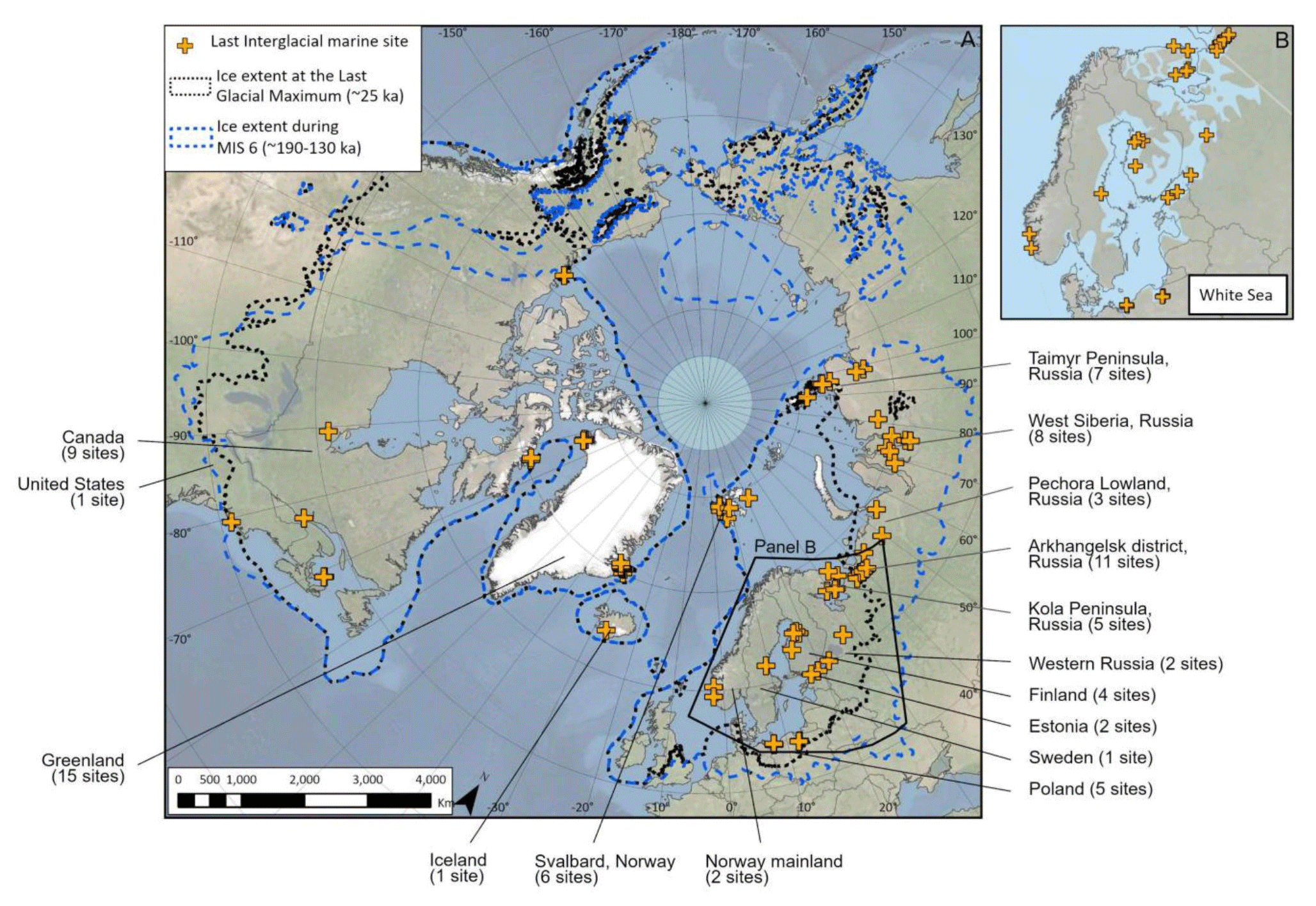
Figure 1Location of last interglacial (LIG) marine sites in the formerly glaciated Northern Hemisphere, along with the extent of MIS 6 and Last Glacial Maximum ice sheets (Batchelor et al., 2019). Inset map shows the extent of the LIG White Sea that inundated the isostatically depressed landscape of western Russia and north-western Europe. Base layer: ArcGIS World Imagery.
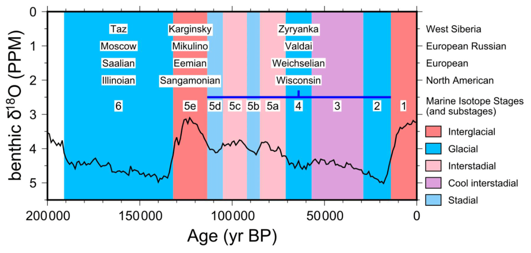
Figure 2The timescales covered in this paper, along with regional nomenclature. The benthic δ18O curve is the LR04 stack, from which the marine isotope stages are derived (Lisiecki and Raymo, 2005).
In the first part of this paper (Sects. 2–5), we define the types of sea-level proxies, elevation measurements, dating techniques and quality assessment, all of which are technical aspects of entering the LIG data into the WALIS database. In Sect. 6, we describe each LIG site in detail, paying particular attention to the elevation of marine sediments and any geochronological constraints. In Sect. 7, we present sites containing LIG marine sediments that are not in situ and have been transported and/or glaciotectonized following deposition. These sites are unsuitable as precise indicators of relative sea level (RSL) and are therefore excluded from the WALIS database. However, they contribute to the general picture of LIG sea level and are therefore included here. In the discussion (Sect. 8) we provide an overview of the LIG sites compiled for this paper as well as examples of marine deposits of other ages in the glaciated region, notably MIS 7 (243 to 191 ka), MIS 5c (peak 96 ka), MIS 5a (peak 82 ka) MIS 3 (57–29 ka) and Holocene (11.5 ka to the present day; Fig. 2). We conclude with suggestions for future research. As shown in Fig. 2, the LIG is known regionally as the Kazantsevo interglacial (Siberia, here however redefined as Karginsky per Astakhov, 2013), the Mikulino interglacial (Russia), the Eemian (western, central and northern Europe), the Ipswichian (United Kingdom), the Langelandselv interglaciation (Greenland) and the Sangamonian (North America).
Our approach to describing sea-level proxies differs from the standard approach used in most of the studies in WALIS. Since most of the LIG sites are located in places that were undergoing rapid sea-level changes dominantly due to glacial isostatic adjustment (GIA) rather than global sea-level change, it is essentially impossible to pinpoint when sea level was at a particular elevation (especially given the large uncertainty in the dating methods). In many locations, there are indications of regression from an often indeterminate highstand position at deglaciation to a position below the elevation of the outcrop. For many sites, there is clear evidence of coarse-grained, wave-influenced deposits that show that sea level was near the elevation of the investigated deposit. The indicative meaning of these deposits, as defined by Rovere et al. (2016), is not sufficiently clear to deduce a precise sea-level position.
We regard it as more useful to describe the sea-level proxies in terms of changes in sea level at each site during the LIG. Accordingly, this compilation is mainly intended for researchers who are interested in inferring the size of the MIS 6 ice sheets through GIA modelling (e.g. Lambeck et al., 2006). In the database descriptions (Dalton et al., 2021), we have indicated the relative water depth based on the geological descriptions at the sites (i.e. deep water, shallow water, near sea level, above sea level). From this information, it should be possible to test the reliability of MIS 6 ice sheet reconstructions.
In our database (Dalton et al., 2021), the vast majority of the sea-level proxies are denoted as “marine limiting”. The entered elevation marks the highest elevation of marine sediments at a site. This usually marks an unconformity between the marine sediments and overlying younger sediments that date to between MIS 5d and MIS 1 (started at 14 ka; see Fig. 2). In a few cases, the contact is a conformable transition from marine to terrestrial (often fluvial or lacustrine) sedimentation. At sites where there is reasonably high confidence of the indicative meaning (generally where there is confidence of the sea-level highstand), we have defined them as sea-level indicators using the standard approach of WALIS (i.e. Rovere et al., 2016) and note that sea level likely never exceeded that elevation. At sites where there is evidence of a regression and transgression within the LIG, we have created two entries in the database. Based on the amount of information on sea-level position and variations at a site, we have assigned a quality score, which will be elaborated on in Sect. 5.
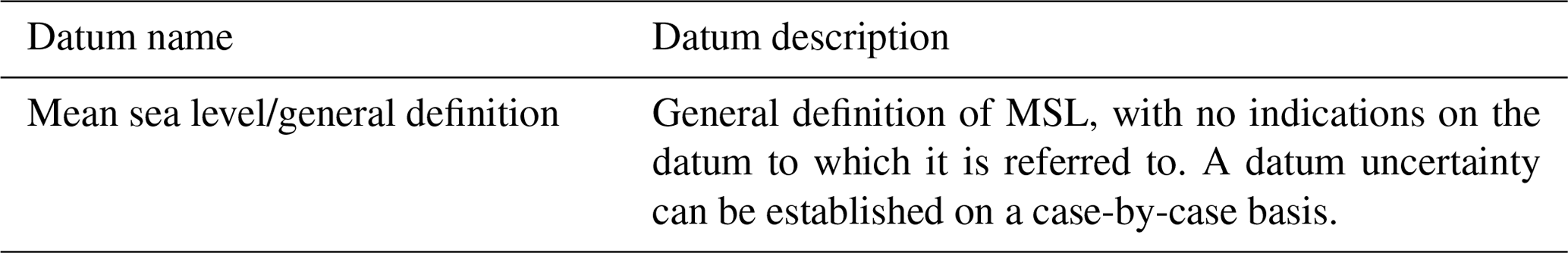
A summary of elevation measurement techniques and datums, as used in cited research, is found in Tables 1 and 2. However, techniques used to measure the elevation(s) were often not stated in the studies covered in our database and were instead extracted from stated elevations and section diagrams in the original publications. In these cases, we applied a nominal uncertainty of 20 % of the stated elevation, as recommended by Rovere et al. (2016), or 10 m, whichever was smaller. It is unlikely that the elevation uncertainty will be worse than the contour intervals of typical topographic maps (10–20 m), provided the authors were precise in pinpointing the location of their site. For studies that involved the authors of this paper, we were able to provide the details of the elevation measurements and provide narrower uncertainties. The datum used was not stated in most of the studies presented here and is assumed to be referenced to present-day mean sea level. The tidal range in most locations covered in our database is presently relatively small (i.e. <1–2 m), so this is unlikely to add significant uncertainty.
Table 1Measurement techniques used to establish the elevation of LIG marine deposits (Rovere et al., 2020). GPS: Global Positioning System.
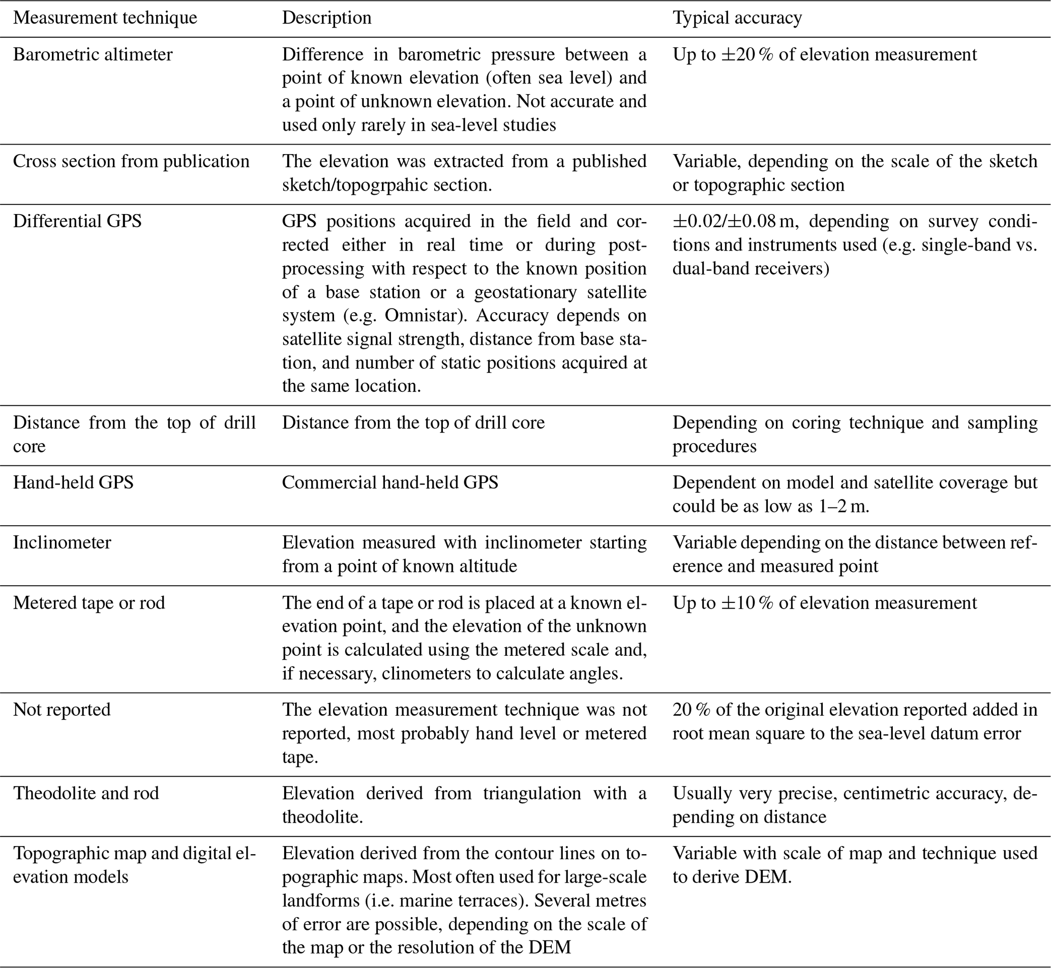
Table 2Sea-level datums reviewed in this study (Rovere et al., 2020).
A large number of dating techniques have been applied to LIG marine deposits covered in our database. These dating techniques include absolute (luminescence, electron spin resonance), minimum limiting (radiocarbon), and relative approaches (amino acid racemization, stratigraphy, environmental conditions). Generally, the absolute dating techniques have relatively large uncertainties and cannot be used to give a precise timing of deposition within the LIG. When combined with palaeo-environmental conditions, it can usually be concluded that the deposit has a LIG age rather than being part of another period of high sea level (e.g. Holocene, MIS 3, MIS 5a/c, MIS 7; see Fig. 2). Consideration of quality of the age control in the database is elaborated in Sect. 5.
4.1 Amino acid racemization dating
Amino acid geochronology measures the racemization of amino acids. For the LIG, the epimerization of D-alloisoleucine to L-isoleucine is most used (known as the DL ratio; Oldale et al., 1982; Miller and Mangerud, 1985). Older shells have a higher isoleucine epimerization ratio than younger shells. However, this is a relative dating technique, with the epimerization controlled by regional diagenetic temperature, among other factors (Andrews et al., 1983). Therefore, this technique can only be used for correlation between sites or to differentiate between different marine incursions in each region, rather than to give precise ages.
4.2 Radiocarbon dating
Radiocarbon dating measures the amount of radioactive carbon (14C) remaining in organic material after death of the dated animal/plant. The time since death can be approximated by consideration of the mean half-life (5.73 ka) of 14C (Stuiver and Polach, 1977) and then converted to calendar year via calibration (Reimer et al., 2020). However, this chronological method is only useful for samples less than ∼ 45 000 years old because the remaining 14C in old samples is too scarce to be reliably measured beyond that point, and the sample becomes increasingly susceptible to modern-day carbon contamination (Douka et al., 2010). Thus, for the purposes of identifying LIG marine sites, radiocarbon ages offer only minimum constraint.
4.3 Stratigraphic inferences
In many cases, the stratigraphic position of a particular marine unit provides evidence of its age. When the marine unit is overlain by tills that are independently assigned to MIS 5d/b (peak MIS 5d conditions were at 87 ka), MIS 4 or MIS 2 glaciation, stratigraphic context is used as evidence to support a LIG age assignment (e.g. at Põhja-Uhtju and Peski; Miettinen et al., 2002; Sect. 6.22–6.23). As another example, sometimes the presence of a till directly underneath the marine sediments suggests significant isostatic depression (often related to the MIS 6 glaciation), which along with evidence of rapid marine inundation into the isostatically depressed landscape and shallowing of marine waters is used as evidence of a LIG age assignment (e.g. Isle-aux-Coudres; Occhietti et al., 1995; Sect. 6.45).
4.4 Palaeo-environmental inferences
Climate during the LIG was several degrees warmer than present-day temperatures in the Northern Hemisphere (Rasmussen et al., 2003; Sánchez Goñi et al., 2012). As a result, palaeo-indicators of warmer-than-present-day conditions are often used as support for a LIG age assignment. Marine-based palaeo-ecological indicators commonly preserved in the stratigraphic record include dinoflagellate cysts, foraminifera, Coelenterata, Bryozoa and Mollusca, diatoms, and marine gastropods (Bergsten et al., 1998; Mangerud et al., 1981). In the terrestrial sediments that often overlie the LIG marine unit, pollen assemblage zones (PAZs) and Coleoptera are some of the most used markers for determining palaeo-temperature (Dredge et al., 1992; Miettinen et al., 2002). Some caution is needed when considering these to be correlating with the LIG in the absence of other numerical dating methods, as it is possible that these deposits could be from an older interglacial period. In our database, we refer to any site with environmental conditions supporting LIG assignment as an “Eemian interglacial deposit”, as defined by Mangerud et al. (1979).
4.5 Thermoluminescence dating
A common dating method for LIG marine sediments is thermoluminescence (TL), although in recent years it has been largely replaced by optically stimulated luminescence (OSL, described in Sect. 4.1.7). The TL technique measures the last exposure of a sediment to sunlight via the resetting of electrons (Huntley et al., 1985; Lamothe and Huntley, 1988). In a laboratory setting, these changes are measured by heat stimulation. Either quartz or feldspar can be used, although feldspar is susceptible to anomalous fading, which can lead to large uncertainties in the age estimation because the electrons trapped in the crystal lattice “leak” over time (Godfrey-Smith et al., 1988; Huntley et al., 1985).
4.6 Infrared stimulated luminescence dating
The infrared stimulated luminescence dating (IRSL) method uses wavelengths in the infrared range to induce luminescence in feldspar, which in some cases has been shown to reduce uncertainties in age estimates compared with TL (Godfrey-Smith et al., 1988).
4.7 Optically stimulated luminescence dating
Similar to TL dating, OSL measures the refilling of shallow electron traps in sediment grains that occur during burial following exposure of the sediment grain to sunlight; therefore, the time since burial can be obtained (Duller, 2008; Huntley et al., 1985). In a laboratory setting, the release of these electrons is induced by light stimulation, and the escaping dose is measured. A key consideration in OSL dating is the former depositional context (largely shallow marine settings in our dataset) and its impact on bleaching (zeroing) of the sediments by sunlight as well as the burial history of the sediment. Generally, OSL is considered to be more reliable than TL and IRSL.
4.8 Electron spin resonance dating
Electron spin resonance (ESR) dating estimates the time since deposition of certain materials (largely molluscs in our database) by measuring the trapping of electrons within the material's crystal lattice. Key factors are the radiation occurring from the enclosing sediment as well as the radioactivity of the sample (Grün, 1989). The precision of the age from ESR dates on mollusc shells is complicated, since the shells have an open system to uranium (Schellmann and Radkte, 1999). As a result, care must be taken in interpreting ESR ages, and the uncertainty can be larger than the stated analytical uncertainty. The analytical techniques used to determine ESR ages for many of the sites in our database are described in detail in Molodkov (1988) and Molodkov et al. (1998).
4.9 Uranium–thorium dating
As with ESR dating, uranium–thorium () dates from mollusc shells are complicated to interpret since the shells have an open system to uranium and rely on assumptions about the exchange of the element with the surrounding environment. As a result, this technique is not commonly applied to LIG deposits. This method was used to constrain the age of deposits at two sites in our database (Miller et al., 1977; Israelson et al., 1994). For the latter, the age provided only minimum constraint.
4.10 Tephrochronology
At one site in our database (the Galtalækur site in Iceland; Vliet-Lanoë et al., 2018; Sect. 6.40), tephrochronology is used to support the LIG age assignment. Contained within the marine sediments is a tephra layer that was linked via geochemical analyses to a specific eruption (Grimsvötn volcano), which was, in turn, constrained to the LIG based on the position of the Grimsvötn tephra in North Atlantic marine sediment cores (Davies et al., 2014).
4.11 Potassium–argon dating
At one site in our database (the Galtalækur site in Iceland; Vliet-Lanoë et al., 2018), potassium–argon () dating is used to constrain the age of a glacio-volcanic unit that underlies the LIG marine unit. This method measures the rate of decay from K to Ar and was possible at this specific site owing to the presence of volcanic rocks. It is otherwise not a common dating method in Quaternary research.
At each LIG marine site documented in the WALIS database there is a quality assessment rating for the RSL proxies. In the WALIS documentation, the standard RSL rating is designed for far-field sea-level indicators, in which a precise assignment of sea-level position can often be determined. For glaciated areas where sea level was rapidly changing due to glacial isostatic rebound after the end of the MIS 6 glaciation, this type of quality assessment is not as useful, especially since the dating techniques are not precise enough to pinpoint when the marine sediments were deposited. As one of the primary uses of this database will be GIA modelling, we have devised a rating scheme to assess the usefulness for this purpose (Table 3). The best-quality RSL proxies are sedimentary sequences that have well-documented elevation measurements and in which there is a clear transition from deep marine to shallow marine, beach, and terrestrial environments. A high rating is also assigned if it can be proven that sea-level position remained above a threshold for a long period of time, i.e. for most or all of the LIG. The rating decreases when there is less geological evidence of sea-level position changes and proximity to sea level.
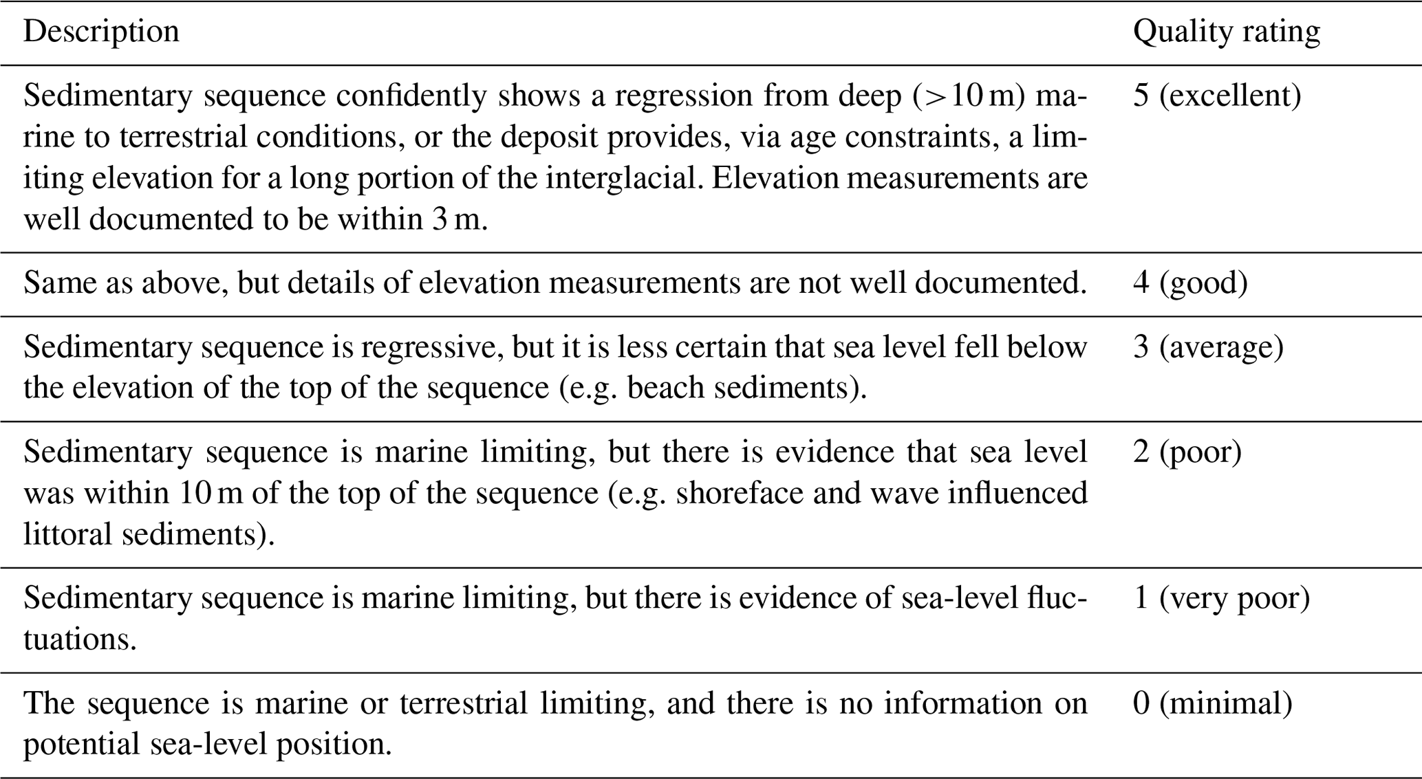
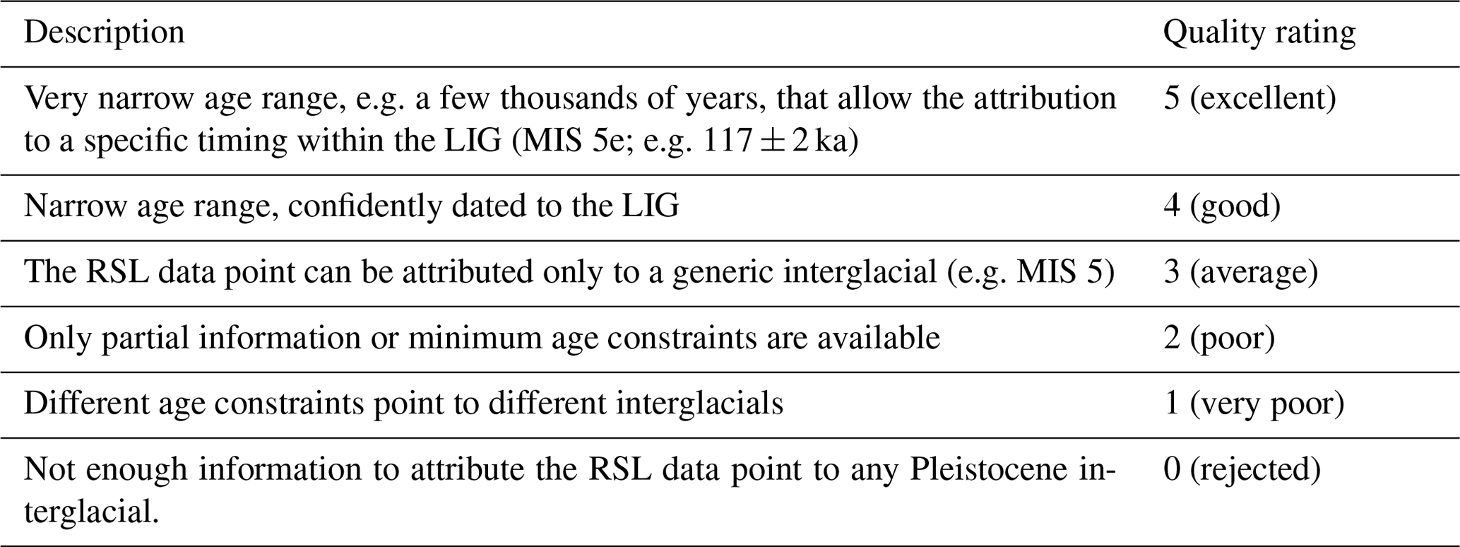
The chronological rating for each LIG site follows the WALIS standard (Table 4) and is determined by how precise the age of the marine deposit can be constrained. In the standard WALIS documentation, higher chronological scores are generally only assigned for dated corals that can have precision of less than a few thousand years, which is not the case in the techniques applied to glaciated region sea-level proxies. Despite this, based on stratigraphy and environmental proxies, there is reasonable confidence that most of the proxies documented in our database fall either within the LIG, during the latest part of MIS 6 when the ice sheets were retreating, or during the early parts of MIS 5d when ice sheets began to grow again. Without environmental indicators, it can be difficult to distinguish deposits that might instead date to the sea-level highstand that happened after the MIS 5d glaciation (e.g. Mangerud et al., 1998). For North American sites, a high rating assignment from environmental conditions alone is not applied, as the LIG stratigraphy is not as well understood as in Europe (Otvos, 2015). Sites that have multiple age determinations increase the confidence in our LIG age assignment. However, the precision of the techniques is never high enough to elevate any site rating to the highest level.
Table 4Quality scores for age, from the WALIS documentation (Rovere et al., 2020).
The primary challenge of assessing past sea level in formerly glaciated areas is that the sea-level position likely did not remain fixed for any length of time. Moreover, the dating techniques that can be applied to LIG deposits lack the precision to determine when sea level was at a specific elevation (with the possible exception of the correlation with European pollen records, if such long-distance correlations are valid). Therefore, we chose to describe the proxies in terms of how much information they give to show sea-level variations in the LIG. Most of the studies we looked at lack information on how elevation was determined. However, we were able to include this information in the database for sites that involved the authors of this study. Since a large portion of sites described here were overridden by ice sheets during the last glacial period (MIS 2; see Fig. 1), most of the sections are incomplete due to erosion.
Here, we describe sites from the formerly glaciated Northern Hemisphere that contain in situ LIG marine sediments, ordered roughly from east to west and sorted by country. Geochronological results are reported for all the sites where data are available. Sediments overlying or underlying the marine strata are generalized unless they provide additional context for the LIG marine event. We offer no interpretation of tectonics, GIA or eustacy. Elevation measurements are in metres above sea level (m a.s.l.) or metres below sea level (m b.s.l.). Owing to the global scale of this database, it is not possible to map all features/locations described in the text (especially rivers), and the reader is referred to the original publications for specific local site information. Additional details (including site coordinates, elevation of marine sediments, and quality scores for both RSL and age determinations) are summarized in Table 5 and detailed in the database of Dalton et al. (2021).
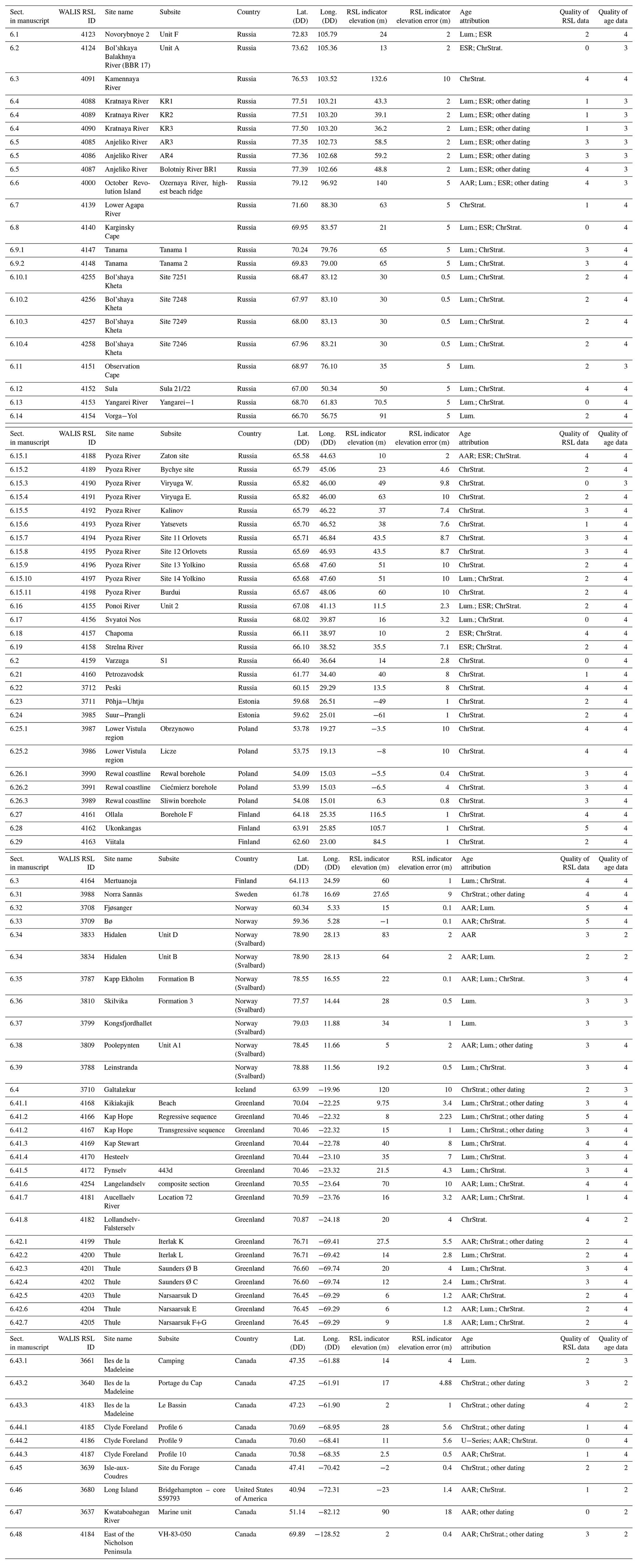
Table 5Summary of LIG sites from the glaciated Northern Hemisphere that contain RSL indicators. Further details are available in Dalton et al. (2021). AAR: amino acid racemization; Lum.: luminescence; ESR: electron spin resonance; ChrStrat.: chronostratigraphy. Comprehensive documentation of each site (including detailed sea-level measurements and chronological data) is available at https://doi.org/10.5281/zenodo.5602212 (Dalton et al., 2021).
6.1 Novorybnoye 2, Taimyr Peninsula, Russia
On the southernmost Taimyr Peninsula, ∼ 30 m-high river bluffs close to the small settlement of Novorybnoye, on the southern shore of the Khatanga River, expose a complex Mid- to Late-Pleistocene stratigraphy (Fig. 3b). As described in Kind and Leonov (1982), this record encompasses three glacial till units on top of Cretaceous sandstone; the till beds are described as interbedded with two marine sediment successions, the lowermost to be, in their terminology, LIG in age and the upper one sandwiched between two Early Zyryanka tills (MIS 5d–5a). This chronostratigraphy was, however, not substantiated by any numerical ages. The Novorybnoye bluffs were reinvestigated by Möller et al. (2019a, b), resulting in two more observed marine units and a very different chronology in which the lowermost marine unit probably dates to MIS 9–11 (424–337 ka). Relevant to the present study, the LIG marine sediments span 14.8–24 m a.s.l. and are divided into two units: F1 and F2. Marine unit F1 (spanning 14.8–21.5 m a.s.l.) is at the base a glaciomarine clayey silt with numerous occurrences of ice-rafted debris. Above these marine sediments are stratified and normally graded sandy shoreface sediment (F2) with an abundance of Hiatella arctica and Astarte sp. shells from 21.5 to 24 m a.s.l. An OSL age of 124 ka is supported by a mollusc ESR date at 131 ka; Möller et al. (2019a) thus concluded that this entire marine unit (F1–F2) represents marine inundation following deglaciation and sediment deposition during isostasy-driven shore regression at the transition from MIS 6 into the LIG. The absolute height of unit F sediments is ≥25 m a.s.l., which is a minimum deglacial sea-level altitude.
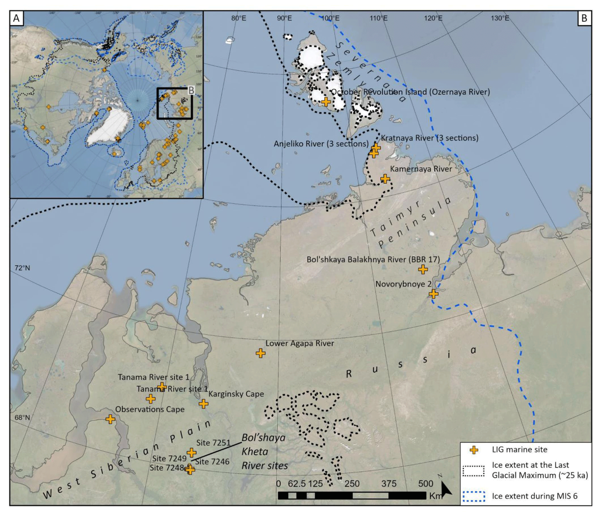
Figure 3The location of LIG marine sites in the Taimyr Peninsula and West Siberian Plain, Russia. Panel (a) situates the sites in the Northern Hemisphere, whereas panel (b) provides a regional map. Sites plotted on this map are detailed in Sect. 6.1–6.11. Extent of MIS 6 and Last Glacial Maximum ice sheets after Batchelor et al. (2019). Scale calculated at the centre of the mapped area. Base layer: ArcGIS World Imagery.
6.2 Bol'shaya Balakhnya River (BBR 17), Taimyr Peninsula, Russia
In the lower reaches of the Bol'shaya Balakhnya River (Fig. 3b), a sediment succession shows marine silty clay with dispersed ice-rafted debris situated between 6.2 and 7 m a.s.l. (site BBR 17B) and between 7 and 13 m a.s.l. (site BBR 17A). At BBR 17B, there is an upper erosional contact with fluvial sediment at 7 m a.s.l. (Möller et al., 2019a, b; Der Sarkissian et al., 2020). The mollusc fauna in the marine sediments is dominated by arctic Portlandia arctica, but there is also an abundant occurrence of subarctic taxa, Buccinum undatum, Mytilus edulis and Macoma baltica, suggesting higher-than-present influx of Atlantic water. Electron spin resonance ages on P. arctica are 101–105 ka (n=3) and indicate an MIS 5c age (known locally as Early Zyryanka). However, two molluscs in the above-lying fluvial sediments (OSL-dated to a MIS 3 age, the molluscs redeposited from erosion of the underlying marine sediment) yield ESR ages of 122 and 123 ka. These dates, together with the interglacial-type mollusc fauna composition, clearly set the marine sediments into the LIG, with however poor indication of sea level at deposition.
6.3 Kamennaya River, Taimyr Peninsula, Russia
Around the Kamennaya River (Fig. 3b), which is a tributary to the Leningradskaya River, Gudina et al. (1983) described several sites exposing marine and nearshore marine sediments forming regressive terraces from 133 to 40 m a.s.l. (site no. 373 located at the highest altitude of 133 m a.s.l.). The sediment successions are divided into a lower coarsening upwards member, from silts and clays to cross-bedded sand, and an upper member of sand and gravel. All sediments are rich in molluscs, predominantly Astarte borealis, A. crenata, A. montuagi, Macoma calcarea, Hiatella arctica and Mya truncata (i.e. species that are arctic to non-conclusive in their biogeography). As opposed to the molluscs, the foraminifera association (48 species detected) has a dominance of subarctic species, thus suggesting warmer-than-present sea temperatures. Based on the latter, Gudina et al. (1983) suggested that the marine sediments in the Leningradskaya basin were deposited at shore regression during the LIG.
6.4 Kratnaya River sections, Taimyr Peninsula, Russia
Three river-cut sections along the Kratnaya River (denoted KR1, KR2 and KR3; Fig. 3b) expose a thick basal till on top of which are marine sediments with a slight upwards-coarsening trend with offshore silt and sand grading into shoreface-deposited sand with gravel stringers (Möller et al., 2008, 2015). The base of these marine sediments is situated at 37 m a.s.l. and the uppermost logged sediments reach ∼ 43 m a.s.l., but the marine sediment succession can locally be followed upslope to at least 50 m a.s.l. The sediments host a variable abundance of molluscs with Hiatella arctica, Mya truncata and Astarte borealis as dominating taxa (all arctic to non-conclusive in their biogeography). Six ESR ages on molluscs from the marine sediment form an age cluster between 111 and 142 ka, while two OSL dates gave younger ages of 84 and 100 ka (Möller et al., 2008, 2015). The ESR ages firmly suggest a transition from the MIS 6 glaciation (known locally as the Late Taz) into the LIG for the emplacement of this regressive marine sediment succession.
6.5 Anjeliko River sections, Taimyr Peninsula, Russia
Based on the composite stratigraphy of five river-cut sections (three of which have LIG sediments and are included in the database) along and in the vicinity of the Anjeliko River (Fig. 3b), Möller et al. (2008, 2015) report three marine units intercalated with glacial tills and suggested that two of these marine events, together with underlying tills, represent two full glacial cycles coupled with marine inundation and regression following deglaciations. Relevant to the present study, the intermediate marine unit consists of glaciomarine debris flow sediments followed by an upwards-coarsening sediment succession of offshore clay and silt into shoreface/foreshore sand. These marine sediments are situated between 55 and 58 m a.s.l. Outside of logged sediment successions, the marine sediments could be followed to ∼ 80 m a.s.l. and, if observations from investigations by Mirošnikov (1959) and Šnejder (1989) from other nearby locations (notably on Cape Chelyuskin) refer to the same sediments, they might have a highest altitude of up to 140 m a.s.l. The sediments host a variable abundance of the molluscs Hiatella arctica, Mya truncata and Astarte borealis as dominating taxa, all arctic to non-conclusive in their biogeography. Three ESR ages on molluscs from the marine sediment yielded ages of 143, 145 and 156 ka, while two OSL ages suggested 79 and 135 ka (see Möller et al., 2015). The age envelope (disregarding the 79 ka OSL age) suggests a transition from the MIS 6 glaciation (known locally as the Late Taz) into the LIG for this marine sediment succession. The uppermost glacial–marine sediment succession in the Anjeliko River area dates from a glaciation followed by marine inundation during MIS 5d–5c (known locally as the Early Zyryanka; see Möller et al., 2008).
6.6 Ozernaya River, October Revolution Island, Russia
October Revolution Island is located offshore of the Taimyr Peninsula, in the Severnaya Zemlya archipelago, Arctic Russia (Fig. 3b). On this island, along the north–south-flowing Ozernaya River, are occasional exposures of up to 50 m-thick palaeo-valley fill sediment successions, ordered in a pancake-like stratigraphy. First briefly described by Bolshiyanov and Makeyev (1995), a more in-depth description was made in Möller et al. (2007), showing four till beds (Till I–IV) interbedded with three marine units (Marine I–III). Relevant to the present study, Marine unit III is situated between 75.5 and 80.5 m a.s.l. (sites Oz1b and 1d). These marine sediments can laterally be followed to higher ground with no covering till (sites Oz2 and 3; see Fig. 5a in Möller et al., 2015), eventually terminating in sets of beach ridges, the highest at ∼ 140 m a.s.l. In the database (Dalton et al., 2021), we have treated the highest-elevation beach ridge as a sea-level indicator. The marine sediments show a general coarsening upward trend with offshore to shoreface-deposited silt and clay with varying frequency of ice-dropped clasts, continuing into massive or vaguely stratified sand (site Oz1) and finally beach-face gravels (sites Oz2 and 3). Besides arctic molluscs such as Hiatella arctica, Mya truncata and Astarte borealis, the marine sediments also host biogeographically subarctic species such as Chlamys islandica and Buccinum undatum. The foraminifera fauna is also mainly arctic, but a warmer-water indicator is Trifarina cf. angulosa and the also occurring Elphidium ustulatum and Islandiella inflata that are rarely found in deposits younger than the LIG in Europe (Möller et al., 2007).
The age of the Marine unit III is not straightforward, as discussed in Möller et al. (2007, 2015). Electron spin resonance ages on the mollusc fauna have an age envelope of 77–105 ka (n=8), while ESR ages on nearby found Chlamys islandica are 105 and 120 ka (Bolshiyanov and Makeyev, 1995). Optically stimulated luminescence ages on the sediment show an age envelope of 143–176 ka (n=11). Based on the stratigraphic position in a regional context, the interglacial fauna elements in the marine sediments and an evaluation of the numerical ages from dating attempts, Möller et al. (2007) favoured an interpretation that the Marine unit III sediments in the Ozernaya River valley were deposited at the transition between the MIS 6 glaciation (known locally as the Late Taz) and the LIG and that the deglacial sea had a highstand of at least 140 m a.s.l.
6.7 Lower Agapa River, Taimyr Peninsula, Russia
In the lower reaches of the Agapa River (Fig. 3b), several river sections display three marine units (Gudina et al., 1968; later reinvestigated by Sukhorukova, 1998). The lowermost unit is interbedded fine sand and silt with the boreal bivalve Cyprina islandica (now Arctica islandica) followed by silt and clay (Unit 2), 30–35 m thick, spanning 30 to ≥63 m a.s.l. Unit 2 hosts a rich mollusc fauna (16 subarctic (arcto-boreal) and 20 arctic species), with however no species list given. The foraminifera fauna also suggests a component of Atlantic water inflow. Marine Unit 2 with interglacial-type marine fauna reaches ≥63 m a.s.l., which is a minimum sea-level altitude for these deeper marine sediments. The presented biostratigraphy strongly suggests that Unit 2, with a warmer-water fauna, represents interglacial conditions, most likely the LIG.
6.8 Karginsky Cape, West Siberian Plain, Russia
At Karginsky Cape (Fig. 3b), West Siberian Plain, Kind (1974) described a ∼ 16 m-thick sequence of marine sands and silts situated between 5 and 21 m a.s.l., sandwiched between two tills. This site is the LIG marine stratotype for this region (Karginsky Formation; see stratigraphy in Fig. 4). These marine sediments contain shells of the biogeographically arctic to non-conclusive molluscs Astarte borealis, Macoma calcarea, Mya truncata and Ciliatocardium ciliatum as well as the subarctic Mytilus edulis. Shells of a typical boreal mollusc, Arctica islandica, were found only on the beach. The sequence also contains remains of plants presently growing some 3–5∘ (approximately 300–500 km) to the south, suggesting it was deposited during a warmer interval. Conventional radiocarbon dates obtained in this section were 42, 42, 46 and ≥52 ka. However, the first ESR date on an Arctica islandica shell yielded an age of 121.9 ka (Katzenberger and Grün, 1985; Arkhipov, 1989). The LIG age of this marine formation was later confirmed by six OSL dates in the range of 117–97 ka (Astakhov and Nazarov, 2010b; Nazarov, 2011; Nazarov et al., 2018, 2020).
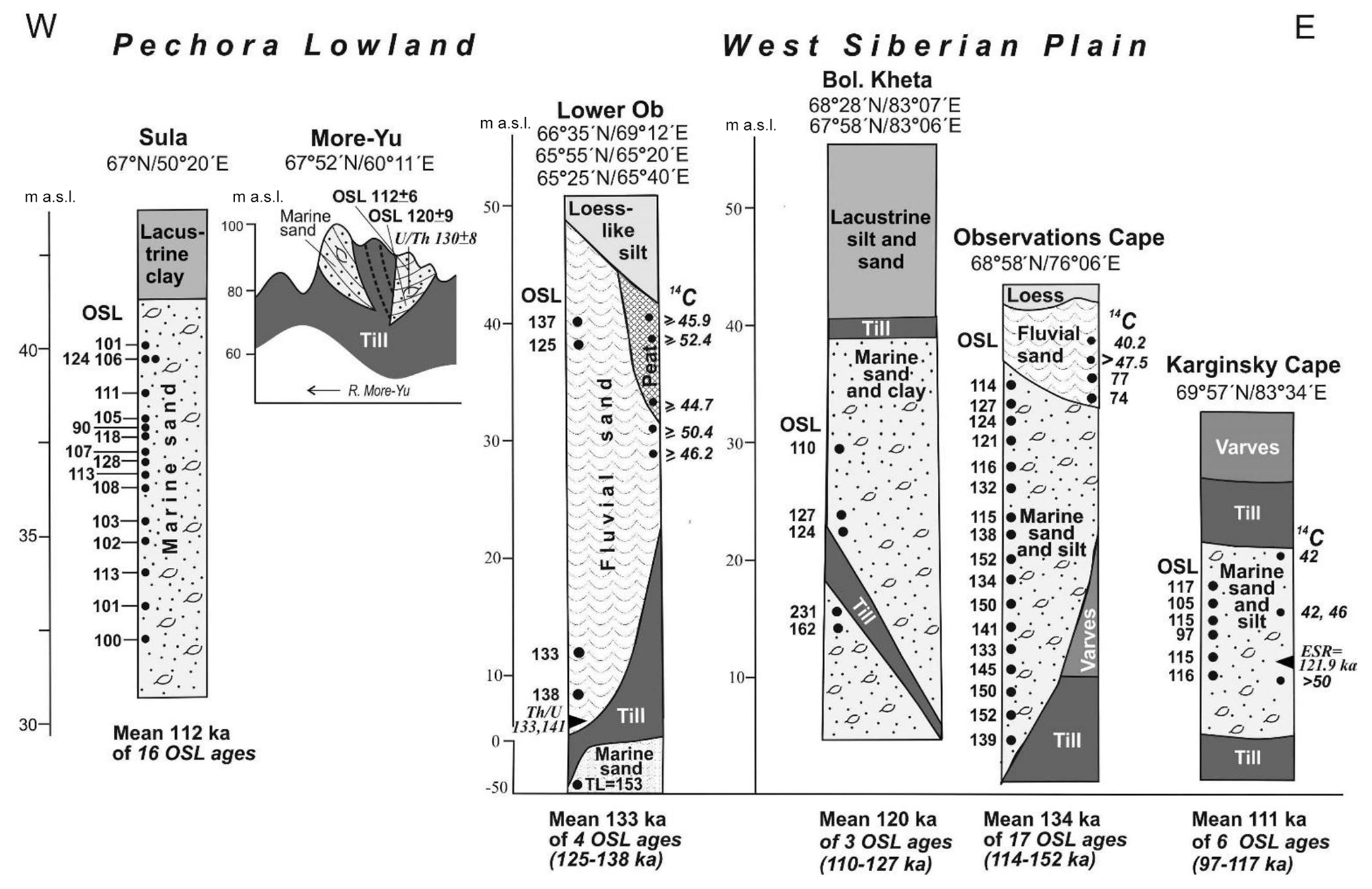
Figure 4An overview of the best-dated sections of the LIG in the Russian Arctic mainland. Numbers along the columns are geochronometric ages (ka). Relative positions of samples are shown by black dots: large ones – dated by optical luminescence; smaller ones – dated by radiocarbon. Black triangles indicate dates by and ESR methods. Sources of information: Sula (Murray et al., 2007), More-Yu (Astakhov and Svendsen, 2002), Nadym Ob (Astakhov et al., 2004, 2005), Observations Cape (Astakhov and Nazarov, 2010a, b), Bol'shaya Kheta (Nazarov et al., 2020), and Karginsky Cape (Astakhov, 2013; Nazarov et al., 2020). These stratigraphic sections are sometimes summaries of several sites; see text for details. Comprehensive documentation of each site (including detailed sea-level measurements and chronological data) is available at https://doi.org/10.5281/zenodo.5602212 (Dalton et al., 2021).
6.9 Tanama River, West Siberian Plain, Russia (two sites)
Along the Tanama River (Fig. 3b), Nazarov et al. (2021) describe marine sediments overlying till from the Taz (MIS 6) glaciation, below which are marine sediments from an earlier interglacial (interpreted as MIS 7 based on OSL dates). The upper unit of marine sediments (known locally as the Payuta marine formation) consists of sands and silts, with numerous shells of Arctica islandica, which indicates warmer-water conditions. The unit is associated with terraces that reach an elevation of 60–70 m a.s.l. The change in slope at 70 m took on the appearance of strandlines. Overlying the marine sediments are lacustrine and alluvial sediments that yielded ages in the range of MIS 4–3.
6.9.1 Tanama site 1
The unit is associated with terraces that reach an elevation of between 60 and 70 m a.s.l.
6.9.2 Tanama site 2
The unit is associated with terraces that reach an elevation of between 60 and 70 m a.s.l.
6.10 Bol'shaya Kheta, West Siberian Plain, Russia (four sites)
In the West Siberian Plain, there are LIG outcrops along the Bol'shaya Kheta River (Nazarov et al., 2020, 2021; Astakhov and Semionova, 2021). First described by Volkova (1958), these sites contain a similar stratigraphic record that can be traced along the river sections, with LIG marine sediments generally ranging from 5 to 40 m a.s.l. (stratigraphy and ages summarized in Fig. 4). The upper marine formation was assigned to the LIG by Saks (1953). This marine unit contains only the extant species Cyrtodaria siliqua and C. kurriana and a rare occurrence of the boreal Arctica islandica. These sites are mapped in Fig. 3b.
6.10.1 Site 7251, Bol'shaya Kheta River
At this site, the upper marine sand and clay beds are situated between 20 and 30 m a.s.l. Two OSL ages on these marine sediments yielded ages of 124 ± 3 and 121 ± 11 ka (Nazarov et al., 2020, 2021; Astakhov and Semionova, 2021). These marine sediments directly overlie a till of MIS 6 age.
6.10.2 Site 7248, Bol'shaya Kheta River
Located 55 km south of site 7251, marine sand and clay beds are located between 5 and 30 m a.s.l. Three OSL attempts on these marine sediments yielded ages of 110 ± 16, 127 ± 20 and 114 ± 12 ka (Nazarov et al., 2020, 2021; Astakhov and Semionova, 2021).
6.10.3 Site 7249, Bol'shaya Kheta River
Marine sand and clay are located between 5 and 30 m a.s.l. (Nazarov et al., 2021). No chronological constraints are available for this site, but the marine unit can be traced along the riverbank to the other sites dated to the LIG.
6.10.4 Site 7246, Bol'shaya Kheta River
Marine sand and clay beds are located between 5 and 30 m a.s.l. (Fig. 3; Nazarov et al., 2021). A single OSL age of 132 ± 11 ka suggests deposition during the LIG (Nazarov et al., 2021).
6.11 Observations Cape, West Siberian Plain, Russia
On the tip of the Taz Peninsula, West Siberian Plain, the Observations Cape site (Fig. 3b) contains parallel laminated sand, silt and clay with an abundance of boreal molluscs such as Modiolus sp. and Zirphaea crispata and subarctic species such as Buccinum undatum, Macoma balthica and Mytilus. Described and dated by Astakhov and Nazarov (2010b), these marine sediments are situated between 3 and 35 m a.s.l. and yielded six OSL dates with a mean age of 135 ka (stratigraphy and ages summarized in Fig. 4), leading to a LIG age assignment. These marine sediments are underlain by Middle Pleistocene glacial till and overlain by fluvial sand with OSL ages of 77 and 74 ka.
6.12 Sula, Pechora Lowland, Russia
In the Pechora Lowland (Fig. 5b), the best-dated LIG site is the succession of shoreline sands along the Sula River, a left tributary to the Pechora River (denoted sites 21/22). The sand formation was originally described as lying on top of marine clay with a cool-indicating mollusc fauna (Lavrova, 1949); the latter, however, was not confirmed by later descriptions. The well-exposed marine sand spans the interval 31–41 m a.s.l., starting with thin foreshore gravel in tabular foresets containing paired shells of subarctic Mytilus edulis (stratigraphy and ages summarized in Fig. 4). The upwards-fining and bioturbated sand contains abundant shells of boreal molluscs Arctica islandica and rare shells of Cerastoderma edule and Zirphaea crispata – all species not presently living east of the Kola Peninsula. This mollusc fauna is typical for a shallow sea with positive bottom temperatures and occurs through the sand formation, topped by a cross-bedded beach gravel. The marine unit, attributed to the LIG, is overlain by fluvial sand and cryoturbated black silty clay of glaciolacustrine origin, topped by aeolian silt (Mangerud et al., 1999). An approximate LIG age was later confirmed by numerous OSL dates, altogether 16 ages in the range of 90–128 ka with a mean age of 112 ± 2 ka (see Fig. 3 and Murray et al., 2007).

Figure 5The locations of LIG marine sites in the Arkhangelsk district and Pechora Lowland, Russia. Panel (a) situates the sites in the Northern Hemisphere, whereas panels (b) and (c) provide regional maps. Sites plotted on this map are detailed in Sect. 6.12–6.15. Extent of MIS 6 and Last Glacial Maximum ice sheets after Batchelor et al. (2019). Scale calculated at the centre of the mapped area. Base layer: ArcGIS World Imagery.
6.13 Yangarei River, Pechora Lowland, Russia
Marine sediments of a LIG age are also found at much higher elevations within the Pechora Lowland (Fig. 5b). As an example, marine sand with mollusc shells occurs along the Yangarei River at 70 m a.s.l., the sediments yielding OSL ages of 121.6 ± 9.2 and 114.8 ± 8.9 ka (Astakhov and Semionova, 2021).
6.14 Vorga-Yol section, Pechora Lowland, Russia
Also in the Pechora Lowland, OSL ages of 126 ± 8, 131 ± 8 and 149 ± 10 ka were obtained from sand with shell fragments at 90 m a.s.l., directly underlying the terminal glaciofluvial delta at the Vorga-Yol section (Astakhov and Semionova, 2021; Fig. 5b).
6.15 Pyoza River, Arkhangelsk district, Russia (11 sites)
Marine sediments assigned to the LIG (known locally as the Mikulinian) were first noted in stratigraphic records along the Pyoza River, in the Arkhangelsk district, in the early–mid 20th century and examined more recently by Houmark-Nielsen et al. (2001) and Grøsfjeld et al. (2006). We describe 11 sites below, which are all mapped in Fig. 5b–c.
6.15.1 Zaton
First discovered by Ramsay (1904), the Zaton site (Site 0 of Houmark-Nielsen et al., 2001) was examined by Devyatova and Loseva (1964) and Devyatova (1982). As described most recently by Grøsfjeld et al. (2006), the entire LIG marine sequence spans 2–11 m a.s.l. At the base of the section, from 2 to 7.5 m a.s.l., are marine clays with a gradual transition into silty sands, interpreted as an offshore to shoreface sediment succession (>45 to <12 m water depth). At the top of the section, from 7.5 to 10 m a.s.l., are laminated sand and silt, separated by gravel horizons. These sediments are interpreted as deposited in a higher-energy coastal/tidal environment with channel erosion and infilling (foreshore environment; <12 m depth). Capping this sediment succession, from 10 to 11 m a.s.l., are cross-bedded fluvial sands. Marine molluscs, dinoflagellate cysts and benthic foraminifera are present throughout (Grøsfjeld et al., 2006). The stratigraphy observed at this site is laterally continuous for ∼ 800 m.
Several geochronological attempts have been made at the Zaton site. Early TL dating on sediments overlying the marine unit yielded an age of 93 ka, which supports a LIG age for the underlying marine sediments (Hütt et al., 1985). Amino acid dating on shells from the marine unit yielded mean a DL ratio of 0.051 ± 0.006, which is “slightly higher than expected” but “probably Eemian” according to Miller and Mangerud (1985). Subsequent ESR dating confirmed a LIG age for this marine deposit (120–82 ka; Molodkov and Raukas, 1988; Molodkov and Bolikhovskaya, 2002). A LIG age is also suggested by pollen analyses (Devyatova, 1982); according to the established pollen-based LIG climate for western Europe (Zagwijn, 1996), marine sediments at this site span the entire interval from ∼ 133 to ∼ 119.5 ka (Grøsfjeld et al., 2006). Moreover, molluscs from this site suggest warmer-than-present-day conditions (notably, Corbula gibba and Balanus improvises), which also supports a LIG age (Grøsfjeld et al., 2006).
6.15.2 Bychye
The Bychye site (sometimes spelled “Bychie”; Site 1 of Houmark-Nielsen et al., 2001 and Grøsfjeld et al., 2006) was first described by Devyatova and Loseva (1964) and again by Devyatova (1982). As described most recently by Grøsfjeld et al. (2006), the stratigraphy at this site is similar to the Zaton site. The entire marine sequence spans from 12.5 to 23 m a.s.l. At the modern-day river level (∼ 12 m a.s.l.) is a till unit, which is overlain by marine clays that gradually coarsen into clayey silt (12.5–19 m a.s.l.; >45 m water depth). These sediments are terminated by an erosional horizon (at 19 m a.s.l.), indicating falling sea level (Grøsfjeld et al., 2006), followed by laminated sand and silt separated by gravel horizons with channel incisions (from 19 to 23 m a.s.l.), interpreted as a regression sequence (shoreface/tidal environment; <12 m water depth). Marine molluscs, dinoflagellate cysts and benthic foraminifera (Grøsfjeld et al., 2006) are present throughout. The stratigraphy at this site is laterally continuous for ∼ 500 m.
The marine sediments at the Bychye site are assigned to the LIG based on palaeo-environmental and stratigraphic inferences. Pollen data (examined by Devyatova, 1982) suggest correlation with the ∼ 133 to ∼ 124 ka interval (Grøsfjeld et al., 2006) LIG climate for western Europe (Zagwijn, 1996). Various marine molluscs, dinoflagellate cysts and benthic foraminifera suggest a transition from cooler-than-present to warmer-than-present temperatures, which supports the capturing of the MIS 6 deglaciation, followed by establishment of LIG warmer marine conditions (Grøsfjeld et al., 2006).
6.15.3 Viryuga W
Located on the northern side of the Pyoza River, the Viryuga W site (Site 4 of Houmark-Nielsen et al., 2001, and Grøsfjeld et al., 2006) was first described by Devyatova and Loseva (1964). Our descriptions are derived from the more recent examination by Houmark-Nielsen et al. (2001) and Grøsfjeld et al. (2006). At the base is a marine unit (spanning 21–39 m a.s.l.) containing stratified sands with shells. A till is present between 39 and 45 m a.s.l. Capping the stratigraphic section is an upper marine unit (spanning 46–49 m a.s.l.), consisting of a clayey diamict containing abundant Mya truncata and Macoma calcarea shells, often paired and thus suggesting in situ preservation. Dinoflagellate cysts and benthic foraminifera are present throughout (Grøsfjeld et al., 2006).
The lower marine unit yielded OSL ages ranging between 237 and 194 ka, suggesting an ice-free interval during MIS 7 (Houmark-Nielsen et al., 2001). Accordingly, Grøsfjeld et al. (2006) interpreted the upper marine sediments as the earliest part of the LIG. Correlation of pollen data from this site with the climate for western Europe (Zagwijn, 1996) places the upper marine sediment unit between ∼ 133 and ∼ 130 ka (Grøsfjeld et al., 2006). Marine molluscs and benthic foraminifera suggest cooler-than-present conditions during this time, which suggests deposition began during the MIS 6 deglaciation at the beginning of the LIG (Grøsfjeld et al., 2006). However, because the upper marine sediments themselves remain undated and the stratigraphic context is unclear, earlier workers (Devyatova and Loseva, 1964; Houmark-Nielsen et al., 2001) interpreted this upper unit as Weichselian-aged (e.g. late MIS 5).
6.15.4 Viryuga E
The Viryuga E site (Site 6 of Houmark-Nielsen et al., 2001, and Grøsfjeld et al., 2006) was first described by Devyatova and Loseva (1964) and again by Grøsfjeld et al. (2006). Following Grøsfjeld et al. (2006), the basal interval at this site is a clayey till between 56 and 58 m a.s.l., inferred to have been laid down during the MIS 6 glaciation. The till is, with a sharp boundary, overlain by clayey glaciomarine sediment between 58 and 60 m a.s.l., interpreted as deposited during LIG marine inundation and sea-level highstand following collapse of the MIS 6 ice sheet. Capping the stratigraphy is marine, mollusc-bearing cross-bedded sand with gravel (60–63 m a.s.l.), interpreted as shoreface deposits. Marine molluscs, dinoflagellate cysts and benthic foraminifera are present throughout (Grøsfjeld et al., 2006). Marine molluscs and benthic foraminifera suggest cooler-than-present conditions during deposition, followed by warmer-than-present molluscs; together, these data suggest deposition during the deglacial phase at the end of MIS 6 and into the early LIG (Grøsfjeld et al., 2006). Water depths were likely >45 m at time of deposition. Correlation of pollen data from this site with climate for western Europe (Zagwijn, 1996), along with the stratigraphic context, places the marine sediments between ∼ 133 and ∼ 130 ka (Grøsfjeld et al., 2006).
6.15.5 Kalinov
At the base of the Kalinov site (Site 8 of Houmark-Nielsen et al., 2001, and Grøsfjeld et al., 2006) marine clays are interbedded with sands (situated from 28 to 37 m a.s.l.). The sediment succession was interpreted as deposited in a lower shoreface environment (Grøsfjeld et al., 2006). The marine sediments are capped by fluvial sands from 38 to 40 m a.s.l. The marine clay interval contains marine molluscs, dinoflagellate cysts and benthic foraminifera (Grøsfjeld et al., 2006). The correlation of pollen data from this site with climate for western Europe (Zagwijn, 1996) places the marine sediment succession between ∼ 133 and ∼ 130 ka (Grøsfjeld et al., 2006). Marine molluscs and benthic foraminifera suggest cooler-than-present conditions during this time, which suggest deposition during the deglacial phase at the end of MIS 6 and into the early LIG (Grøsfjeld et al., 2006).
6.15.6 Yatsevets
At the base of the Yatsevets site (Site 10 of Houmark-Nielsen et al., 2001 and Grøsfjeld et al., 2006) is a till situated between 32 and 34 m a.s.l. Overlying this till is a sequence of marine clay between 33 and 38 m a.s.l., containing marine molluscs, dinoflagellate cysts and benthic foraminifera (Grøsfjeld et al., 2006). Molluscs and benthic foraminifera suggest cooler-than-present conditions during sediment deposition and with an increasing water depth (>45 m depth), which support deposition during the deglacial phase at the beginning of the LIG (Grøsfjeld et al., 2006). Correlation of pollen data (Devyatova and Loseva, 1964) from this site with the climate for western Europe (Zagwijn, 1996) place the marine sediment deposition between ∼ 133 and ∼ 130 ka (Grøsfjeld et al., 2006).
6.15.7 Site 11 Orlovets
The Orlovets site contains almost entirely laminated marine silts that coarsen upward (from 38 to 43.5 m a.s.l.), the sediment succession interpreted as deposited in a lower shoreface environment (Grøsfjeld et al., 2006). The laminated silts are capped by sand and gravel, interpreted as deposited in a foreshore environment. Numerous marine molluscs, dinoflagellate cysts and benthic foraminifera are present throughout, all suggesting slightly warmer marine conditions than the present day (Grøsfjeld et al., 2006). According to the established LIG climate for western Europe (Zagwijn, 1996), marine sediments at this site potentially span from ∼ 128 to ∼ 124 ka (Grøsfjeld et al., 2006).
6.15.8 Site 12 Orlovets
The stratigraphic record at Site 12 Orlovets is identical to that of Site 11 Orlovets. Laminated marine silts that coarsen upward (from 38 to 43.5 m a.s.l.) were interpreted as deposited in a lower shoreface environment (Grøsfjeld et al., 2006). At this site, however, the marine interval is capped by sand, interpreted to be deposited in a fluvial environment (Grøsfjeld et al., 2006).
6.15.9 Site 13 Yolkino
Site 13 Yolkino was first described by Devyatova and Loseva (1964) and later by Houmark-Nielsen et al. (2001) and Grøsfjeld et al. (2006). At the base of the section is marine sand containing molluscs, dinoflagellate cysts and benthic foraminifera, between 48 and 51 m a.s.l. Correlation of pollen data from this site with the climate for western Europe (Zagwijn, 1996) places marine sediment deposition between ∼ 130 and ∼ 128 ka, and the marine molluscs suggest warmer than present-day conditions (Grøsfjeld et al., 2006). The marine sediments are overlain by a series of organic-bearing lacustrine sediments, dated by OSL to 89 ka (Houmark-Nielsen et al., 2001), as well as tills and fluvial sediments.
6.15.10 Site 14 Yolkino
The stratigraphic record at Site 14 Yolkino is identical to that of Site 13 Yolkino. Importantly, marine sand containing molluscs, dinoflagellate cysts and benthic foraminifera are situated at the base of this stratigraphic section between 48 and 51 m a.s.l. An OSL age on these marine sediments suggests deposition at 124 ka (Houmark-Nielsen et al., 2001).
6.15.11 Burdui
Marine sand at the Burdui site (Site 24 of Houmark-Nielsen et al., 2001, and Grøsfjeld et al., 2006) is situated between 59 and 60 m a.s.l. These sediments are overlain by a 1 m interval of proglacial sand, dated by OSL to 97 ka (Houmark-Nielsen et al., 2001). Marine molluscs, dinoflagellate cysts and benthic foraminifera are present throughout (Grøsfjeld et al., 2006). Analysis of the marine molluscs suggest warmer conditions than the present day (Grøsfjeld et al., 2006). According to the established LIG climate for western Europe (Zagwijn, 1996), the marine sediments at this site seemingly span an age interval from ∼ 131 to ∼ 130 ka (Grøsfjeld et al., 2006).
6.16 Ponoi River, Kola Peninsula, Russia
The Ponoi site is in the Ponoi River valley on the eastern part of the Kola Peninsula (Fig. 6b). The most complete section in the area is about 20 m thick and was studied by Lavrova (1960), Nikonov (1966), Gudina and Yevzerov (1973), Ikonen and Ekman (2001) and Korsakova et al. (2016). According to the latter two studies, a till at the base of the section (interpreted as deposited during MIS 6) is overlain by a marine clay unit (denoted unit 2) with sand and gravel interbeds. This clay unit is situated between 7 and 11 m a.s.l. and contains sporadic unbroken mollusc shells and shell fragments. The mollusc, foraminifera, and diatoms, together with palynological and lithostratigraphical evidence, suggest that the marine clay can be correlated with the LIG. Overlying this marine unit are stratified sands and gravels with shell detritus and unbroken shells. This upper unit is 8 m thick and has a sharp lower contact with the underlying marine clays (Korsakova et al., 2016). Mollusc shells and sand in this upper unit have been dated via ESR and OSL to between 96 ± 8 and 71.9 ± 8.2 ka indicating that this upper sand was deposited during MIS 5a–c (Early Weichselian substage; see Korsakova et al., 2016). This age assignment for the uppermost sediments supports a LIG age for the underlying marine clays. Capping the entire stratigraphic section is a glacial unit consisting of glaciolacustrine silt with clast and a till unit (Korsakova et al., 2016).
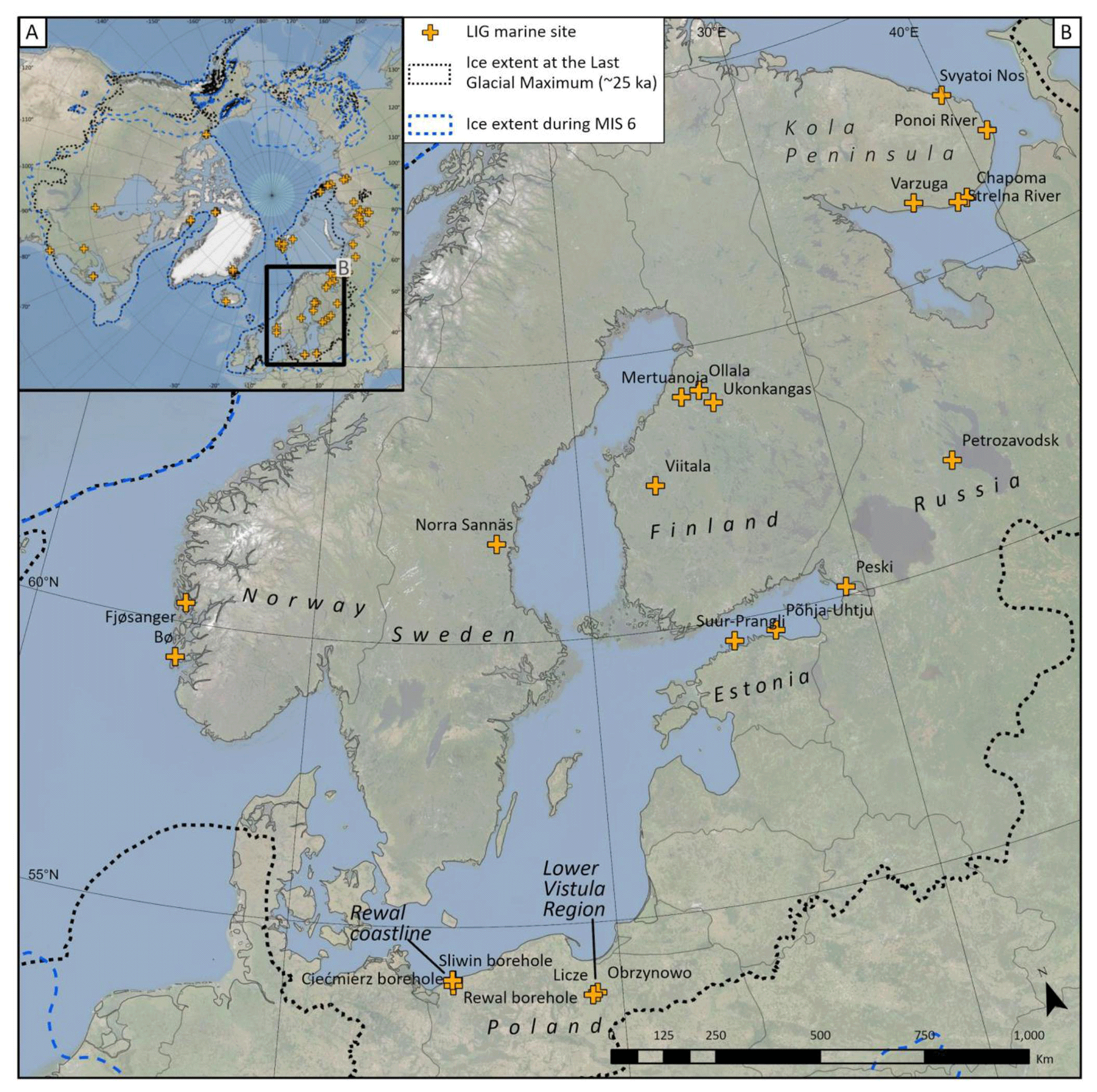
Figure 6The location of LIG marine sites in western Russia, Estonia, Poland, Finland, Sweden and Norway. Panel (a) situates the sites in the Northern Hemisphere, whereas panel (b) provides a regional map. Sites plotted on this map are detailed in Sect. 6.16–6.33. Extent of MIS 6 and Last Glacial Maximum ice sheets after Batchelor et al. (2019). Scale calculated at centre of mapped area. Base layer: ArcGIS World Imagery.
6.17 Svyatoi Nos, Kola Peninsula, Russia
The Svyatoi Nos site is located on the north-eastern coast of the Kola Peninsula (Fig. 6b). As described by Korsakova (2019, 2021), the MIS 6 (known locally as the Moscovian glaciation) glaciomarine sediments are overlain by marine mollusc-bearing silty sands that are present between 11 and 16 m a.s.l. The mollusc species indicate sublittoral faunal assemblage (e.g. Ikonen and Ekman, 2001) and temperate saline water conditions (e.g. Korsakova, 2019). Based mainly on mollusc, foraminifera, and pollen results, the silty sands are thought to have been deposited during the LIG (Gudina and Yevzerov, 1973; Ikonen and Ekman, 2001; Korsakova, 2009, 2019) despite the slightly younger IRSL age of 109.9 ± 10.9 ka obtained from these sands.
6.18 Chapoma, Kola Peninsula, Russia
In the south-eastern part of the Kola Peninsula (Fig. 6b), exposures at the Chapoma site occur in the river terraces on the bank of the Chapoma River, about 3.4 km from the river mouth (Gudina and Yevzerov, 1973). The exposure is approximately 25 m high. A till bed at the base is suggested to have been deposited during MIS 6 (known locally as the Moscovian glaciation; see Gudina and Yevzerov, 1973; Korsakova et al., 2004; Korsakova, 2019). Relevant to the present study, the till bed is overlain by clay, silt and sandy silt beds that span 6.5–10 m a.s.l., and with abundant mollusc shells (Korsakova, 2019). The foraminifera fauna identified from these marine sediments include a rich and relatively warmwater-indicating fauna with species such as Bulimina aculeata, Bolivina pseudoplicata and Hyalina baltica (e.g. Gudina and Yevzerov, 1973; Ikonen and Ekman, 2001). Pollen data from the marine sediments indicate a succession from a closed to open Betula–Pinus forests. Electron spin resonance dating obtained from molluscs at 9 m a.s.l. yielded ages of 128 ± 7.5 and 138.5 ± 9.6 ka, which supports deposition during the LIG. An additional marine bed at this section post-dates the LIG and was likely deposited during MIS 5a (see Discussion).
6.19 Strelna River, Kola Peninsula, Russia
Located just south of the Kola Peninsula, the Strelna site is situated approximately 7 km upstream from the mouth of the River Strelna (Fig. 6b). Many researchers, for example Grave et al. (1969) have studied the lithostratigraphy and biostratigraphy for this >16 m-thick sediment succession. The most recent summary of previous work is given in Korsakova (2019). At the base of this site is a 2.5 m-thick unit of mollusc-bearing fine sand and silt situated between 33 and 35.5 m a.s.l. The ESR-dated molluscs from this unit yielded an age of 111.5 ± 11.2 ka. Taken together, the mollusc and diatom assemblages suggest that the basal marine sediments were deposited in a coastal environment, possibly indicating a sea level above 36 m a.s.l. (Korsakova et al., 2016). Pollen evidence suggest that a Betula/Pinus forest existed in the area (Grave et al., 1969). Accordingly, this unit is most likely correlative with the LIG (e.g. Korsakova et al., 2004; Korsakova, 2019).
6.20 Varzuga, Kola Peninsula, Russia
Exposures along the banks of the Varzuga River between the Koytolov and Kletnoy rapids (south of Varzuga village) have been studied by Lavrova (1960), Gudina and Yevzerov (1973), Apukthin (1978) and Lunkka et al. (2018). An exposure located on the right bank of the Kletnoy rapid (Fig. 6b) consists of a marine mollusc-bearing clayey silt at the base of the section (situated between 10 and 14 m a.s.l.), conformably overlain by glaciolacustrine silt and sand-rich silt (Site “S1” of Lunkka et al., 2018). Pollen, diatom and foraminifera indicate that the marine silt was deposited in a sublittoral zone at water depths of 40–50 m during an interglacial stage, correlated with the LIG (Ikonen and Ekman, 2001, and references therein; Lunkka et al., 2018). Although the sedimentary sequence along the banks of the Varzuga River is glaciotectonized in places (Apukthin, 1978), the marine clay/silt situated between 10 and 14 m a.s.l. is in situ, where it is conformably overlain by glaciolacustrine silt at around 14 m a.s.l. These overlying glaciolacustrine silts are thought to have been deposited during a later stage of MIS 5, prior to 88 ka (Lunkka et al., 2018). Capping the stratigraphic sections are two till units interbedded with sand and silt (Lunkka et al., 2018).
6.21 Petrozavodsk, western Russia
Marine sediments assigned to the LIG were first noted in a borehole record from Petrozavodsk, western Russia (Fig. 6b), by Wollosovich (1908). These sediments are located at 40 m a.s.l. and conformably overlie glaciolacustrine clays (Wollosovich, 1908; Lukashov, 1982). A marine origin for these sediments is confirmed by saline diatom taxa (Ikonen and Ekman, 2001) and several mollusc species, suggesting saline conditions on the order of 10 ‰ to 15 ‰ (Funder et al., 2002). The LIG age is based on correlation with the local pollen record (Lukashov, 1982; Ikonen and Ekman, 2001). Based on the pollen taxa and its correlation with the saline diatom taxa, Ikonen and Ekman (2001) showed that the marine phase prevailed in the area for a long time during the LIG, i.e. from the Pinus–Betula PAZ to the Picea–Alnus–Carpinus PAZ (possibly between 130 and 124 ka).
6.22 Peski, western Russia
Miettinen et al. (2002) described a 32 m borehole record from Peski, western Russia (Fig. 6b). Sediments between 9 and 13.5 m a.s.l. were correlated with the LIG. The base of the borehole is a till (interpreted as deposited during the MIS 6 glaciation), followed by a dark bluish, organic-bearing clay and silt deposit containing Portlandia arctica molluscs between 10.5 and 11.5 m a.s.l., interpreted as deposited during relatively deep-water marine conditions. The marine deposit is assigned to the LIG based on palaeo-ecological and stratigraphic context. Pollen data from this interval suggest warm conditions, especially the occurrence of Corylus and Carpinus, which are associated with the climatic optimum of the LIG (Miettinen et al., 2002). Diatoms contained in the marine unit suggest relatively deep-water, planktonic conditions, possibly representing the maximum of the marine transgression (Miettinen et al., 2002). Marine conditions were confirmed by the subsequent identification of dinoflagellate cysts and foraminifera in these sediments (Miettinen et al., 2014). The LIG unit gradually transitions to later-stage MIS 5 deposition, which is distinguished by a change to grey colour and cooler conditions deduced from pollen and diatoms. This transition likely indicates that sea level remained above 13.5 m throughout the entire LIG. Stratigraphically, the marine unit is overlain by a 16 m-thick till associated with the advance of MIS 5d/b ice sheets (Miettinen et al., 2002).
6.23 Põhja-Uhtju, Estonia
Miettinen et al. (2002) described a Quaternary sediment sequence in a 70 m deep borehole from the island of Põhja-Uhtju in Estonia (Fig. 6b). The base of the recorded stratigraphy is composed of sands and silty clay, interpreted as deposited during the MIS 6 deglaciation. Overlying these sediments, between 51 and 49 m b.s.l., is clay and silt, interpreted as marine in origin and suggesting a sea level above the present at that time. Above these are ∼ 35 m of silty clays and tills, associated with later ice advances. The 51–49 m b.s.l. interval is assigned to a LIG marine incursion, an interpretation based on their palaeo-ecological and stratigraphic context. Pollen data, especially the occurrence of Corylus and Carpinus, suggest warm conditions at the climatic optimum of the LIG (Miettinen et al., 2002). The diatom assemblage in these sediments suggest shallow marine to brackish water conditions.
6.24 Suur-Prangli, Estonia
Similar to the nearby island of Põhja-Uhtju, a borehole at Suur-Prangli, Estonia (Fig. 6b) records marine sediments assigned to the LIG. Liivrand (1987) reported a silt/clay sediment succession between 61 and 75 m b.s.l. that is both overlain and underlain by tills. The diatom record suggests brackish-water conditions, followed by a shallow marine environment (Liivrand, 1991). This assignment to the LIG was based on stratigraphic position (bracketed by tills assigned to MIS 6 and MIS 4) and palaeo-climate succession recorded in pollen composition, notably a maximum Picea and Carpinus interval (Liivrand, 1991). As further justification for the LIG age assignment, the pollen assemblage observed at Suur-Prangli show a similar succession to nearby pollen successions (Forsström and Punkari, 1997) and a well-dated LIG pollen record from Germany (Field et al., 1994).
6.25 Lower Vistula region, Poland (two sites)
Extensive late Pleistocene stratigraphic records in the Lower Vistula region of Poland were first described by Roemer (1864). We describe two representative sites that later have been subject to extensive stratigraphic, sedimentological and palaeo-ecological analyses. However, we note that additional occurrences of LIG marine records from this areas are presented in Makowska (1986).
6.25.1 Obrzynowo
A 212 m borehole record from Obrzynowo, Poland (Fig. 6b), was first described in an unpublished report from the Polish Geological Institute at Warsaw University (Janczyk-Kopikowa and Marks, 2002) and was subsequently published in Knudsen et al. (2012). This borehole record (ground surface at 104.5 m a.s.l.) contains a sequence of glacial and interglacial deposits and intersects marine sediments between 108 and 115 m depth, which situates the entire marine sequence between 10.5 and 3.5 m b.s.l. (Janczyk-Kopikowa and Marks, 2002; Knudsen et al., 2012). This record captures a beach/shoreline environment from 10.5 to 6.5 m b.s.l. (fine-grained sand and silt with mollusc shells) that gradually transitions into deeper-water marine deposit from 6.5 to 3.5 m b.s.l. (clays, silts and very fine sands). Dinoflagellate cysts and diatoms confirm saline conditions (Knudsen et al., 2012). These marine sediments are both overlain and underlain by tills, fluvial sediments, varved clays and organic-rich sediments and this site likely documents several glacial–interglacial transitions over the late Quaternary. The marine sequence at Obrzynowo has been assigned to the LIG based on its stratigraphic position and a comparison with the Licze core (discussed next; Head et al., 2005), as well as comparison to other regional pollen successions that have been assigned to the LIG (an interpretation especially based on the presence of Picea and Carpinus; Mamakowa, 1989, 1988).
6.25.2 Licze
A borehole record at the Licze site (ground surface at 87 m a.s.l.; Fig. 6b) records a transition from freshwater to marine conditions between 8 and 14.5 m b.s.l. (Makowska et al., 2001; Zawidzka, 1997) in which there are freshwater molluscs that are gradually replaced by a marine assemblage. The first marine molluscs are present at 13.5 m b.s.l. and they remain common until 8 m b.s.l. (Mamakowa, 1989). Dinoflagellate cysts and diatoms confirm marine conditions through this stratigraphic interval and suggest warmer waters than present-day conditions (Head et al., 2005; Knudsen et al., 2012). Throughout this interval with sediment transition from silty sand to silt and clay suggests an environmental change (transgression) from a beach environment to deeper marine conditions (Makowska et al., 2001). These marine sediments are both overlain and underlain by extensive Quaternary deposits (tills, fluvial deposits, varved clays and organic-rich sediments). These marine sediments are assigned to the LIG owing to their stratigraphic position, along with a comparison to the pollen record at the Obrzynowo site (Head et al., 2005) and to other regional pollen successions, assigned to the LIG (especially due to the presence of Picea and Carpinus; Mamakowa, 1989, 1988)
6.26 Rewal coastline, Poland (three sites)
Marine sediments bracketed by tills were described in several borehole records along the Rewal coastline, Poland, by Krzyszkowski et al. (1999) as well as by Krzyszkowski (2010). The marine sediments consist of fine-grained sand (known as the Rewal Sand) containing a rich assemblage or plant detritus and marine shells (largely boreal Cardium sp. (now Cerastoderma), but also Astarte borealis, and the boreal Thracia popyracea; Krzymińska, 1996). Krzyszkowski et al. (1999) suggested that these sediments represent deposition either a lagoon or a beach setting. They were assigned to the LIG based on their stratigraphic position. Both sites are overlain by the Ninikowo Till (assigned to the last glacial cycle) and underlain by the Pustkowo Till (assigned to MIS 6 glaciation; Krzyszkowski et al., 1999). Here, we describe the position of LIG marine sediments in three representative boreholes from this region (sites mapped in Fig. 6b).
6.26.1 Rewal borehole
The Rewal borehole (WH5) encountered a marine sand unit at an elevation between 5.5 and 13 m b.s.l. (Krzyszkowski et al., 1999).
6.26.2 Ciećmierz borehole
The Ciećmierz borehole intersected a thin lens of the Rewal Sands situated between 6.5 and 8 m b.s.l. Additional pollen work suggests boreal conditions at the time of deposition of this marine unit (Krzyszkowski, 2010).
6.26.3 Sliwin borehole
The Sliwin borehole (WH4) encountered the marine unit between 6.3 and 9 m b.s.l. (Krzyszkowski et al., 1999).
6.27 Ollala, Finland
Forsström et al. (1988) described a sediment exposure and four boreholes at Ollala in central Finland (Fig. 6b) on their lithology, pollen, plant macrofossil and diatom content. At borehole F, there is a till (>4 m thick) at the base above the Proterozoic crystalline bedrock. Overlying this till are <1 m of glaciofluvial sands, which then change into silt (situated between 116.25 and 116.5 m a.s.l.) and then thick greenish gyttja (situated from 116.5 to 117.5 m a.s.l.). The silt and gyttja intervals contain diatom taxa indicating a shallow marine (saline and brackish water) basin passing upwards into freshwater diatom taxa, typical for a lake basin. This change from saline to freshwater taxa takes place in the lower part of the gyttja layer at 117 m a.s.l., indicating that the freshwater lake was isolated from the marine basin during the latter part of the LIG, likely the result of GIA uplift. Pollen data from this interval also clearly suggest that these sediments were deposited during interglacial conditions (Grönlund, 1991a, b; Nenonen, 1995). The gyttja unit is overlain by 0.5 m of glacially sheared and compressed organic-rich material that is, in turn, overlain by up to 5 m-thick Weichselian till (Forsström et al., 1987; Grönlund, 1991a). This marine gyttja unit is also present between 116.6 and 116.8 m a.s.l. at nearby borehole B (Forsström et al., 1987; Grönlund, 1991a).
6.28 Ukonkangas, Finland
The Ukonkangas site is a till-covered esker, located 8 km south-east of Kärsämäki, central Finland (Fig. 6b). According to Grönlund (1991b) the Ukonkangas pit exposes gravel at its base, overlain by ∼ 0.5 m-thick bluish, organic-bearing silt (situated between 105.4 and 105.95 m a.s.l.). This silt bed is laterally continuous for 15 m in the exposure, suggesting it is in situ. Grönlund (1991b) interpreted the silt bed as deposited in a littoral zone of the LIG White Sea (Fig. 1), with time becoming more shallow and less saline. Pollen content indicates that the regional vegetation was forested and composed of broad-leaved trees and other pollen (e.g. Osmunda) indicating temperate climatic conditions (Eriksson, 1993). The diatom taxa are typical to the LIG White/Baltic Sea taxa, which also occur at the LIG sites in adjacent areas (Grönlund 1991a, b). The silt unit is overlain by parallel bedded sand, interpreted as beach sand (situated between 105.95 and 108 m a.s.l.; Grönlund 1991b). The top 2 m of the section is composed of till (MIS 2?).
6.29 Viitala, Finland
At the Viitala site, located in western Finland (Fig. 6b), three borehole records documented a clay beneath the MIS 2 till (Nenonen et al., 1991). The clay unit is ∼ 5 m thick. Diatom taxa indicate that the lower ∼ 2 m of the clay was deposited in a large cool and freshwater basin during the early part of the LIG, and that the upper ∼ 3 m was deposited in a brackish/saline littoral zone of the LIG White/Baltic Sea (e.g. Grönlund, 1991a; see Fig. 1). These marine sediments are situated between 81.5 and 84.5 m a.s.l. Pollen data from the entire clay unit suggest a lower birch-dominated zone (∼ 2 m; freshwater sediments) and an upper birch–pin–oak–hazel-dominated zone (∼ 3 m; marine sediments). The interglacial-type pollen taxa and the stratigraphical position of the clay suggest that the clay unit was deposited during the LIG (Nenonen et al., 1991; Eriksson, 1993).
6.30 Mertuanoja, Finland
The Mertuanoja region is in the outskirts of Ylivieska, Finland (Fig. 6b), and is the stratotype area for the LIG of southern Finland (Nenonen, 1995; Eriksson et al., 1999). We present a composite of several sediment exposures studied in the Mertuanoja area. At the base of the stratigraphy is a till, deposited during the Saalian glaciation (MIS 6) (e.g. Nenonen, 1995; Lunkka et al., 2016). Overlying this till is the Mertuanoja Clay (average thickness ∼ 1.6 m), consisting of laminated silt and organic-bearing silty clay in its basal part overlain by a sand layer (2–20 cm thick), which is, in turn, overlain by laminated silt. Diatom data suggest deposition in a freshwater environment in the basal part of the Mertuanoja Clay, changing to marine/brackish water, and then back to freshwater conditions at deposition of the laminated silt and clay above the sand layer (Nenonen, 1995; Eriksson et al., 1999). Relevant to the present study is the transition from the freshwater diatom taxa at the basal part of the Mertuanoja Clay into the marine taxa that takes place at around 59 m a.s.l. Coastal marine conditions are recorded in this stratigraphic record until the sand layer at 60–61 m a.s.l., interpreted as littoral sand. The pollen spectra from the Mertuanoja Clay suggests that it was deposited during interglacial conditions correlated with the LIG (e.g. Grönlund, 1991a; Nenonen, 1995). A sand and gravel unit overlying the Mertuanoja Clay was OSL dated to 110 ± 7 ka (Lunkka et al., 2019), followed by tills and an upper-most sand and gravel unit dated by radiocarbon methods to between 70 and 35 ka (Lunkka et al., 2016).
6.31 Norra Sannäs, Sweden
Sub-till marine sediments were intersected in boreholes in the vicinity of Lake Dellen, central Sweden (Fig. 6b), during field work carried out in the late 1980s and early 1990s. Robertsson et al. (1997) described a representative borehole record from Norra Sannäs (surface at 45 m a.s.l.) that shows a marine (littoral) sequence at 17.35 m depth in the core, which translates to 27.65 m a.s.l. The diatom assemblage in clay sediments suggests deposition during marine to brackish conditions, which abruptly change to freshwater diatoms at 17.1 m depth, suggesting the end of marine conditions (Robertsson et al., 1997). Stratigraphically, the marine sediments are overlain and underlain by tills that have been assigned to MIS 4 and MIS 6, respectively, thus suggesting a LIG age for the marine sediments. This age assignment is also supported by pollen data (Robertsson et al., 1997), which bear a similar succession to other LIG records from the region. The sole geochronological attempt at this site was a radiocarbon dating of the marine sediments that gave an age of 25.48 ka (Ua-1666); Robertsson et al. (1997) considered this age unreliable owing to a very low organic content at the sampled interval.
6.32 Fjøsanger, Norway
The Fjøsanger site, located on the outskirts of Bergen (Fig. 6b), is situated along a small fjord, well inside the extent of the Scandinavian Ice Sheet during large Quaternary glaciations, including MIS 6 and MIS 2. The marine limit was 55 m a.s.l. during the last deglaciation, dated to 11.5 ka (Mangerud et al., 2019). Relevant to the present study, at Fjøsanger there is a continuous sequence of shallow marine sediments, presently situated between 0 and 15 m a.s.l., where molluscs, foraminifera, and pollen show that the climate changed from cold to warmer-than-present conditions and back to cold (Mangerud et al., 1981). The sequence is covered by a till. The fauna, especially the boreal Littorina littorea, and the coarse-grained sediments (gravel) suggest very shallow-water sediments, but beach sediments were not found; thus, sea level was slightly higher. Correlation of the pollen stratigraphy with sites in the Netherlands, Denmark and Germany shows clearly that the warm period represents the LIG, a conclusion supported by the occurrence of the marine gastropod Bittium reticulatum, which is known only from the LIG sediments in Europe (Mangerud et al., 1981), and by TL ages (Hütt et al., 1983). Amino acid stratigraphical correlation with classical European LIG sites yielded slightly high DL values for Fjøsanger, but within uncertainty (Miller and Mangerud, 1985). A surprising, and indeed important, conclusion is that the RSL at Fjøsanger was above 15 m a.s.l. from late MIS 6 through the entire LIG and into MIS 5d (Fig. 7) (Mangerud et al., 1981). We consider this to be a secure conclusion because the Fjøsanger sequence shows a complete LIG succession and 15 m a.s.l. is the elevation of the top of the in situ marine beds. Fjøsanger was one of the first sites where it was demonstrated that the LIG (Eemian) should be correlated with MIS 5e and not with the entire MIS 5 (Mangerud et al., 1979).
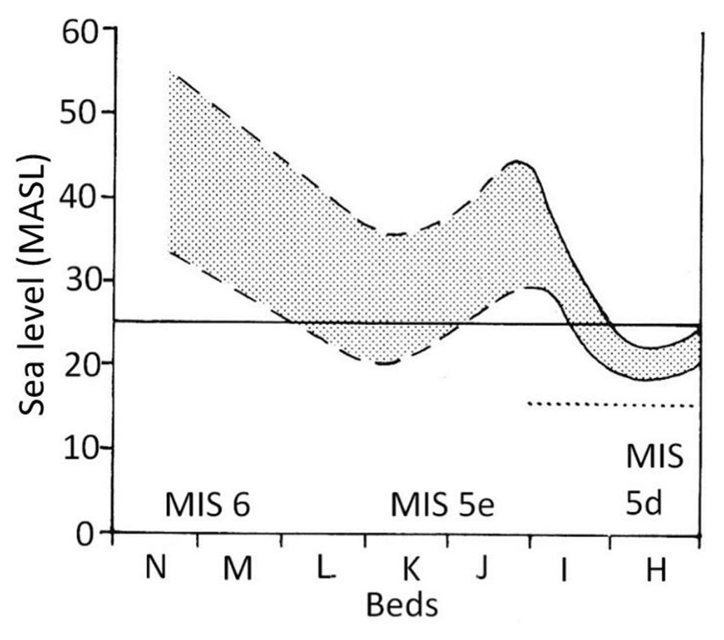
Figure 7Relative sea-level curve for Fjøsanger during the LIG, shown as a dotted uncertainty band. The dashed part of the curve is considered most uncertain. The line at 25 m a.s.l. shows the threshold in the Bergen Valley; when sea level was higher than this threshold the fjord turned into a sound that was open in both ends. The dotted line at 15 m a.s.l. shows the top of the LIG marine sediments and thus the minimum altitude of the RSL during the entire LIG. Modified from Mangerud et al. (1981).
6.33 Bø, Norway
The Bø site is located on the eastern side of the large island of Karmøy on the extreme south-western coast of Norway (Fig. 6b). Like the Fjøsanger site, Bø is situated well inside the extent of the Scandinavian Ice Sheet during large Quaternary glaciations, including MIS 6 and MIS 2. The marine limit was about 16 m a.s.l. during the last deglaciation, dated to 17.5 ka (Vasskog et al., 2019). Relevant to the present study, interglacial sediments were found between 1 and 6 m b.s.l. in an excavation, but only the upper 3 m could be sampled (Andersen et al., 1983). The interglacial sequence was covered by till and other sediments. The pollen stratigraphy (Andersen et al., 1983; Høeg, 1999) and amino acid stratigraphy (Miller and Mangerud, 1985; Sejrup, 1987) clearly shows that this site is LIG in age. The very early part of the interglacial is missing in the samples, but molluscs, foraminifera (Sejrup, 1987) and pollen show that the warmest part is present. Andersen et al. (1983) concluded that LIG RSL was more than 15–20 m a.s.l. because they postulate an open sea connection across the island. Sejrup (1987) described paired shells of the boreal molluscs (Lucinoma borealis and Pecten maximus); these present live-in water depths of 20–50 m, and he postulated that sea level was this high during the LIG but at its lowest at the end of the interglacial. While we cannot determine a precise RSL at Bø, the results support the conclusion from Fjøsanger, namely that sea level in western Norway during the entire LIG was at least 15 m higher than the current sea level.
6.34 Hidalen, Svalbard, Norway
The Hidalen site is in eastern Svalbard, on the island of Kongsøya (Fig. 8b). The marine limit from the last deglaciation is about 100 m a.s.l. (Salvigsen, 1981). The stratigraphy at Hidalen contains three coarsening-upward sequences from marine silt to littoral gravel, separated by till beds (Ingólfsson et al., 1995). The youngest coarsening-upward sequence (Unit F) is of Holocene age, whereas the two older ones have non-finite radiocarbon ages. The oldest (Unit B) obtained a TL age of 148 ka and combined with the amino acid DL ratio, Ingólfsson et al. (1995) considered Unit B to be of pre-LIG age. Based on the amino acid DL values they argued that the younger Unit D is of LIG age. Mangerud et al. (1998) presented two alternative interpretations, the first being the one by Ingólfsson et al. (1995). However, they argued that it was more probable that the oldest Unit B is of LIG age. Kongsøya is a national park with strong regulations, and no Quaternary geologist has later been allowed to go ashore to solve this problem. For the present interest, we state that LIG marine sediments are present on Kongsøya and they span ∼ 50 to >60 m a.s.l. If Unit D is indeed of LIG age, then sea level was up to ∼ 80 m a.s.l. In our database, we have added both units and note the controversy in age.

Figure 8The locations of LIG marine sites in Svalbard, Norway. Panel (a) situates the sites in the Northern Hemisphere, whereas panel (b) provides a regional map. Sites plotted on this map are detailed in Sect. 6.34–6.39. Extent of MIS 6 and Last Glacial Maximum ice sheets after Batchelor et al. (2019). Scale calculated at the centre of the mapped area. Base layer: ArcGIS World Imagery.
6.35 Kapp Ekholm, Svalbard, Norway
The Kapp Ekholm site (mapped in Fig. 8b; field photographs in Fig. 9) is in central Svalbard, ∼ 14 km outside the large Nordenskiöldbreen glacier, which occupies the head of Isfjorden–Billefjorden. This implies that if Kapp Ekholm was ice free, glaciers on Svalbard were not much larger than at present. The marine limit during the last deglaciation was 90 m a.s.l. (Salvigsen, 1984) and the stratigraphy at Kapp Ekholm suggests that this site was repeatedly covered by ice during the Quaternary. The site was first described by Lavrushin (1967, 1969), who found the subarctic mollusc Mytilus edulis within one of the marine formations (Fig. 10). Mytilus requires warmer climate on Svalbard than during the 20th century (Mangerud and Svendsen, 2018). Kapp Ekholm is the only pre-LGM site on Svalbard where Mytilus or other “warm-water” molluscs are found.
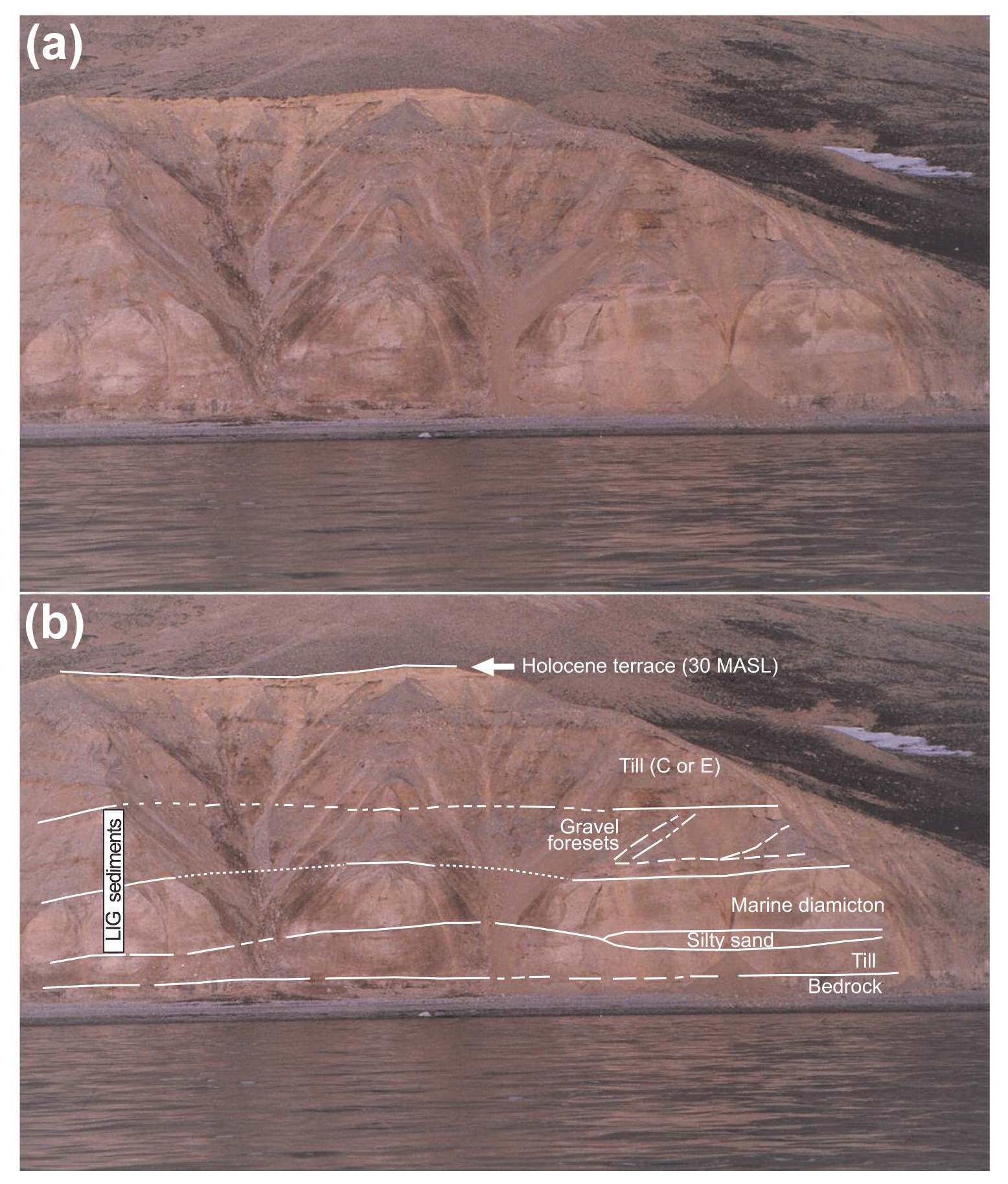
Figure 9Photograph of Sect. II at Kapp Ekholm, Svalbard. Panel (a) is the original photograph, and panel (b) shows stratigraphic units. Solid white line indicates a confirmed stratigraphic contact; dashed line indicates inferred stratigraphic contact (largely due to sediment slumping). The LIG sediments (indicated by the white text box) are about 10 m in thickness. Most Mytilus edulis were found in the lower part of the marine diamicton. Photo Jan Mangerud, 1988.
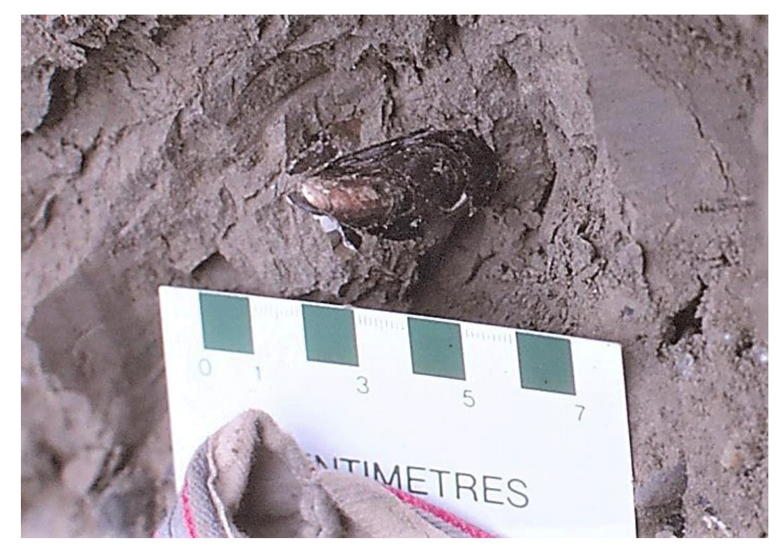
Figure 10Preserved Mytilus edulis in the LIG sediments at Kapp Ekholm, Svalbard. This mollusc requires warmer water than the conditions around Svalbard for the last millennia, until it immigrated in 2004. Photo Jan Mangerud, 1988.
Several marine and glacial units are found in superposition at Kapp Ekholm (stratigraphy shown in Fig. 9). The entire exposure is described in detail by Mangerud and Svendsen (1992); here we will only describe the formation containing Mytilus (“Formation B”), which is situated between 5 and 22 m a.s.l. The lower ∼ 5 m of Formation B contains thick marine mud with numerous floating stones (called “marine diamicton”). The stones have probably rolled down the steep slope from the shore. Molluscs, including thick Mya truncata, in living position, are common, and paired shells of subarctic Mytilus edulis are also found in this unit (Fig. 6). The mud is overlain by thin and almost horizontal sand beds, capped by 12 m-thick, steeply dipping gravel foresets. The latter are interpreted as formed by long-shore drift, and the top (22 m a.s.l.) therefore reflects sea level during the formation. The entire Formation B suggests a shallowing during deposition and thus sea level was considerably higher than 22 m a.s.l. when the mud and sand were deposited. Chronologically, Formation B is dated with five OSL dates that yielded an average of 118 ka (Mangerud et al., 1998), suggesting a LIG age, subsequently supported by several IRSL dates (Eccleshall et al., 2016). Moreover, the frequent occurrence of the “warm-water” demanding Mytilus edulis, suggests that Formation B should be correlated with an interglacial in northern Europe when sea water was warmer than at present. Amino acid DL values also strongly suggest that Formation B cannot stem from an older interglacial.
6.36 Skilvika, Svalbard, Norway
In south-western Svalbard, Skilvika is located on western Spitsbergen (Fig. 8b). The site was first described by Semevskij (1967), and later studied by several scientists. A detailed description was provided by Landvik et al. (1992). The entire Quaternary exposure is 1 km long and stretches up to 35 m a.s.l. Most of the exposure consists of Formations 3 and 4, which are the candidates for the LIG age and together span 15 to 30 m a.s.l. (stratigraphy summarize in Fig. 11). Formation 3 is a coarsening upward sequence from glaciomarine silt, through sand (shoreface) to cross-bedded gravel (foreshore). The overlying Formation 4 consists of a strange sediment, namely foresets of boulders and containing marine fossils in sand lenses between the up to 2 m large boulders. The foresets of Formation 4 interfinger with the beds in Formation 3 (Figs. 11 and 12). The interpretation is that Formations 3 and 4 together represent a prograding beach showing a sea level about 30 m above the present (Landvik et al., 1992). Formation 4 was formed by an advance of the local glacier. There were found neither foraminifera (Lycke et al., 1992) nor molluscs (Landvik et al., 1992) that require as warm water as at present and based on TL ages and amino acid DL values Landvik et al. (1992) concluded a MIS 5c age, which was also accepted by Mangerud et al. (1998), although with the comment that “an Eemian age cannot be ruled out”. Alexanderson and Landvik (2018) then performed an extensive dating program, obtaining 20 OSL ages from Formation 3. The result was a large spread in ages from 66 to 263 ka, although when excluding two outliers the range was 99 ± 7 to 149 ± 17 ka, with a mean of 119 ± 5 ka (n=18). After another quality screening, they obtained a mean age of 118 ± 7 ka (n=10). The conclusion is that Formations 3 and 4 probably are of LIG age, although warm-water species are missing, and a MIS 5c age cannot be excluded. The RSL was about 30 m a.s.l.
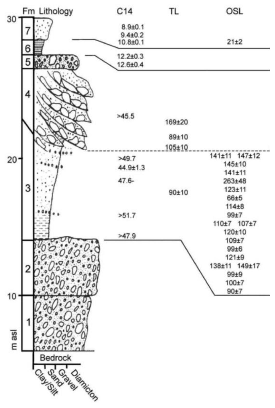
Figure 11Composite log of the Skilvika exposure with luminescence (TL and OSL in ka) and radiocarbon ages (in cal. ka for ages >40 ka, uncalibrated for younger ages). Formations (Fm) 3 and 4 are the candidates for the LIG (from Alexanderson and Landvik, 2018).

Figure 12The upper half of the photo shows the extremely coarse foresets in Formation 4 at Skilvika. Note how the foresets interfinger with the sand and gravel beds in Formation 3. Photo Jan Mangerud, 1984.
6.37 Kongsfjordhallet, Svalbard, Norway
The site Kongsfjordhallet is located on the north shore of Kongsfjorden, north-western Spitsbergen (Fig. 8b). Marine limit during the last glaciation was about 40 m a.s.l. (Lehman and Forman, 1992). These exposures have been studied by several scientists, apparently first by Boulton (1979). The oldest Quaternary marine units are probably about 1 million years old (Houmark-Nielsen and Funder, 1999). In this review we mainly rely on results reported by Alexanderson et al. (2018). Relevant to the present study, units 4 and 5 are considered to be of LIG age. The altitude of these units varies along the ∼ 700 m studied section of the coastline, but they are largely present from 27 to 34 m a.s.l. The base of these sediments is ∼ 1.5 m-thick glaciomarine mud. This is overlain by up to 3 m-thick littoral sand and gravel, suggesting a shallowing due to glacial isostatic uplift. The assumed LIG age is based on two OSL dates with an average of 132 ± 7 ka, supported by a diverse foraminifera fauna (Alexanderson et al., 2018). This age is also consistent with the chronology of the entire sequence. We find it probable that these units are of LIG age, although based on two OSL ages only. The RSL was about 34 m a.s.l. when the littoral sands and gravels were deposited. However, the units are parts of an emergence cycle; thus, sea level was initially higher than indicated by the littoral sediments.
6.38 Poolepynten, Svalbard, Norway
The Poolepynten site is located on the island Prins Karls Forland on the western coast of Spitsbergen (Fig. 8b). The marine limit from the last deglaciation is about 40 m a.s.l. (Forman, 1990). The site was first described by Miller (1982) and later in more detail by Bergsten et al. (1998), Andersson et al. (1999) and Alexanderson et al. (2013). The site has attracted much interest because the oldest known bones of polar bear (Ursus maritimus) were discovered here (Ingólfsson and Wiig, 2009; Lindqvist et al., 2010). In the present review, we mainly rely on results reported by Alexanderson et al. (2013). The exposure shows a sequence of several marine and glacial units with ages between 10 and 130 ka as dated with different geochronological methods. The lowermost unit (named A1 in Alexanderson et al., 2013) is considered to be of LIG age, and is the only unit discussed here. It is exposed between 2 and 4 m a.s.l. and consists of thin sand beds with scattered pebbles, shell fragments and kelp, and it is interpreted as shallow marine or sublittoral deposits. The polar bear jaw was found in this unit.
The LIG age of unit A1 is based on several lines of evidence: the stratigraphical position, amino acid DL values (Miller, 1982), slightly warm foraminifera fauna (Bergsten et al., 1998), the phylogenic position of the polar bear mandible (Lindqvist et al., 2010), and two robust OSL ages of 118 ± 13 and 105 ± 10 ka (Alexanderson et al., 2013). We consider it very probable that Unit A1 is of LIG age and that it indicates a RSL of 2–4 m a.s.l. However, as with all other sites on Svalbard, the unit is interpreted as part of an emergence cycle caused by GIA uplift. Thus, the mentioned sea level does not show the LIG highstand and possibly neither the lowstand.
6.39 Leinstranda, Svalbard, Norway
The Leinstranda site is located on the north-western coast of Spitsbergen (Fig. 8b). The site was discovered by Troitsky et al. (1979) and later studied by several scientists, in most detail by Miller et al. (1989) and Alexanderson et al. (2011b). A synthesis and critical review was provided by Alexanderson et al. (2011a). The marine limit from the last deglaciation is 46 m a.s.l. (Forman, 1990). The sequence consists of several formations of marine, beach and glacial sediments dated to 200–10 ka with different geochronological methods. The units considered to be of LIG age are found between 16 and 19 m a.s.l. The lower part consists of 2 m-thick glaciomarine silt considered to reflect a sea level about 80 m higher than at present. The sediments are coarsening upwards to shoreface sand reflecting a sea level of 20 m a.s.l. at its formation. Almost all dated samples are collected from the shoreface sand. Marine mollusc shells, some being paired, are found in all units. All species are common on Svalbard today.
Miller et al. (1989) found a foraminifera fauna that suggested slightly warmer conditions than at present and named the unit for the Leinstranda interglacial. Their amino acid results suggested a LIG age, which subsequently was supported by IRSL dating (Forman, 1999). We consider four recent OSL dates, with an average of 129 ± 10 ka, to provide the most reliable age (Alexanderson et al., 2011a, b). The conclusion is that Leinstranda represents a LIG site. The sea level was above 20 m a.s.l. when the dated bed was deposited and sea level was thus considerably higher before. Whether sea level later in the LIG dropped even lower due to glacial isostatic uplift is unknown.
6.40 Galtalækur site in Jökulhlaup valley, Iceland
Van Vliet-Lanoë et al. (2018) describe, in central southern Iceland, marine sediments exposed in deeply incised valleys (Rangá, Þjórsá and Hvítá rivers) that formed because of late glacial jökulhlaups (flooding events) from nearby glaciers (Fig. 13b). The Rangá Formation is around 30 m thick and records two separate marine transgressions following the MIS 6 deglaciation of the region. The marine unit (represented by the regional stratigraphic unit R-C2) consists largely of sands draped by thin silt sediment, representing a coastal fluvial setting, where a tidal delta formed in an estuary (Van Vliet-Lanoë et al., 2018). It is best preserved at the Galtalækur site, where it is located at approximated 120 m a.s.l. (extracted from a stratigraphic plot; exact measurements at that site were not provided). The Rangá Formation sediments are assigned to the LIG based on stratigraphic context, absolute dating and tephrachronology. From a stratigraphic standpoint, the Rangá Formation is overlain by extensive deglaciation deposits (tills, glaciofluvial and glacial marine sediments) that are dated to the Holocene via tephrachronology (presence of Vedde ash; Van Vliet-Lanoë et al., 2018). Contained in these marine sediments is a tephra layer from the Grimsvötn volcano which is dated to the LIG based on its position in North Atlantic marine cores (Davies et al., 2014). Both underlying and overlying units that bracket the Rangá Formation have absolute ages. Van Vliet-Lanoë et al. (2018) presented three K-Ar ages on the glacio-volcanic unit that underlies the Rangá Formation between 155 and 129 ka. Two other ages from this unit (using the method) also yielded ages in this range (Clay et al., 2015; Flude et al., 2008).

Figure 13The locations of LIG marine sites in Iceland and Greenland. Panel (a) situates the sites in the Northern Hemisphere, whereas panels (b), (c) and (d) provide regional maps. Sites plotted on this map are detailed in Sect. 6.40–6.42. Extent of MIS 6 and Last Glacial Maximum ice sheets after Batchelor et al. (2019). Scale calculated at centre of mapped area. Base layer: ArcGIS World Imagery.
6.41 Region of Scoresby Sund, East Greenland (eight sites)
Last Interglacial sites in the region of Scoresby Sund, eastern Greenland, were the subjects of intensive research in the early 1990s as part of the Polar North Atlantic Margins; Late Cenozoic Evolution (PONAM) project, which resulted in several papers published in the mid-1990s. A common indicator of LIG age is the presence of warmer-water than today fauna, e.g. Balanus crenatus. Present are also members of the Astarte genus, some arctic and some subarctic to their biogeography (Funder et al., 2002). The presence of Astarte borealis, generally regarded as an arctic species, is, however, thought only possible in this region under conditions of increased advection of Atlantic water, which occurred only during the LIG and the Holocene (Vosgerau et al., 1994). Some sites are also constrained to the LIG based on >20 luminescence ages (Mejdahl and Funder, 1994). Below, we present 8 locations where these LIG sediments were documented in the vicinity of Scoresby Sund. The coordinates for these sites are estimated from maps in the original publications.
6.41.1 Kikiakajik section
At Kikiakajik (Fig. 13c) there is a 700 m long and 10–15 m high coastal cliff, but it is partly covered by perennial snowbanks. Mangerud and Funder (1994) cleaned and described two exposures. The first exposure has a coarsening-upwards sequence from horizontally bedded marine silts at 3.5 m a.s.l. through sand to gravel foresets, which are cut by a till at 7.5 m a.s.l. The second exposure consists only of the gravel foresets at 9–13 m a.s.l., covered by till. The silt and sand contain a molluscs fauna similar to the one described at Kap Hope, including Balanus crenatus and the warmer than today-indicating Astarte borealis. A single shell was radiocarbon dated to >44 ka, and the sand was dated with TL to 132 ± 10 ka. The distinct fauna strongly suggests a correlation between Kap Hope and Kikiakajik, and the warm water requirements of the fauna together with the dates from both sites indicate a LIG age.
6.41.2 Kap Hope
At Kap Hope there is a 20 m high coastal section where Mangerud and Funder (1994) described a marine silt between 2 and 3 m a.s.l., directly overlying bedrock (Fig. 13c). The silt contains a rich Astarte fauna including the warmer-water species Balanus crenatus and Astarte borealis, which are not living in East Greenland today. The fauna suggests an offshore environment warmer than at present. From the silt there is a coarsening upward sequence through sand (well-sorted, ripple laminations with gravel lenses) to gravel (includes well-rounded boulders), representing a regression from offshore through shoreface to beach environment at 10 m a.s.l. The beach sediments are covered by a 5 m-thick sandy gravel interpreted to suggest a rising RSL, eventually capped by a till. Two radiocarbon dates from individual shells gave non-finite ages (>42 ka) and two TL/OSL dates from the shoreface sand yielded 97 ± 10 and 75 ± 8 ka, respectively. Mangerud and Funder (1994) assigned the entire clay–sand–gravel sequence to the LIG based on the fauna and supported by the TL/OSL dates, although the latter yielded too young ages. In the database, we have added separate entries for both the regressive and transgressive units.
6.41.3 Kap Stewart composite
Marine sediments assigned to the LIG are present from 0.5 to 40 m a.s.l. around Kap Stewart (Tveranger et al., 1994; Fig. 13c). In their study, the authors examined several sites to better understand the sedimentology and to find as many fossils as possible. However, ultimately, all sedimentary structures, dates and fossils were assumed to represent one single site, which we follow here. To provide additional context on the LIG marine event, we provide a brief overview of each individual site below.
At Loc. 471 marine sediments interpreted as deposited in a tidal, shallow marine delta environment were found between 9 and 12 m a.s.l. and at Loc. 473 similar sediments were found at 0.5–8 m a.s.l. (Tveranger et al., 1994). These sediments contain marine molluscs suggesting warmer-than-present water. Based on these molluscs and the stratigraphic position below diamicton and more recent sediments, these deposits were assigned a LIG age. From Loc. 473 the interglacial unit could be mapped on the surface some 500 m inland (towards the north) to Loc. 468 where the unit consists of tidally influenced channels and estuarine/lagunal deposits up to about 40 m a.s.l. The unit was mapped through Loc. 470 where it consists of trough cross-bedded sand and gravel located between 30 and 38 m a.s.l. and interpreted as fluvial deposits with palaeo-currents towards the fjord. The interpretation is that the transition from marine to a coarsening upwards fluvial sequence reflects a progradation of the palaeo-Ostraelv river delta. The vertical stacking of tidal channels and the thickness of fluvial deposits indicate that progradation took place during a RSL rise up to about 40 m a.s.l.
6.41.4 Hesteelv composite
Similar to the Kap Stewart site, in the Hesteelv area (Fig. 13c), workers examined several sites to better understand the stratigraphic record (Tveranger et al., 1994). Ultimately, all sediment successions, dates and fossils from studied sections were assumed to represent the same marine unit, situated between 5 and 35 m a.s.l., and tied to the LIG. For additional context on the LIG marine sediment, we provide below a brief overview of some individual sites.
At Hesteelv 13 outcrops, located in an area stretching 5 km along the fjord and 1 km inland, were cleaned and sedimentological logged in detail (Tveranger et al., 1994). Sediment units could (at several places) be traced on the surface between the outcrops and the correlations between the outcrops mentioned here are considered reliable. At Loc. 153 a continuous outcrop was cleaned from 5 to 71 m a.s.l., and this is a key exposure for the full stratigraphy of the area but here we will only describe the LIG sequence (Unit A in Tveranger et al., 1994), which is found at 5–35 m m a.s.l. The lower 15 m consist of 2–50 cm-thick sandy turbidites interbedded with massive or weakly laminated mud layers containing molluscs, dropstones and synsedimentary slumps. The turbidites are overlain by low-angle, cross-stratified sand, with layers of gravel, and sand with climbing ripples and planar cross-bedding. Depositional direction was towards the fjord (i.e. south) throughout the unit. The unit is interpreted as a prograding delta sequence with transition from offshore turbidites to shoreface deposits with migrating bars. The altitude and facies indicate a sea level between 35 and 40 m a.s.l. The interglacial sediments are overlain by a till, interstadial marine sediments and another till and deglacial sediments, not described here. The LIG unit can be followed from Loc. 153 to Loc. 152 (18–30 m a.s.l.) and Loc. 154 (9–33 m a.s.l.) by surface mapping. Both localities have a coarsening upward sequence like that at Loc. 153 and thus support the interpretation there. Last interglacial sediments were described also from some of the other outcrops and fossils collected. At some places erosional, regressive facies are mapped and interpreted as stemming from the subsequent falling RSL. Several terrestrial plant macrofossils (e.g. Betula pubescens), beetles and marine molluscs (e.g. Mytilus edulis) collected from the LIG unit in different outcrops show warmer-than-at-present climate, and mean July temperature was estimated to have been about 5 ∘C (Tveranger et al., 1994). Thus, an interglacial origin is clear. The average of nine OSL ages is 115 ± 29 ka and suggests a LIG age, which is consistent with the full stratigraphy at the site and indeed by correlation with other sites along Scoresby Sund (Vosgerau et al., 1994).
6.41.5 Site 443d, Fynselv area
At Site 443d (Fig. 13c), marine sediments were identified between 12 and 21.5 m a.s.l., dated by TL/OSL to 120 ± 10, 121 ± 10, and 122 ± 10 ka (Hansen et al., 1994). The marine sediment succession was interpreted as deposited in a deltaic to shallow marine environment (units Ib, Ic, Id). These marine sediments are overlain by a till followed by marine sediments, representing a later incursion.
6.41.6 Langelandselv composite
Like the Kap Stewart and Hesteelv sites, workers in the Langelandselv region (Fig. 13c) examined several sites to better understand the stratigraphic record (Landvik et al., 1994). The LIG marine unit (amalgamated from several sites) spans 0–70 m a.s.l. For additional context on the LIG marine sediment, we provide below a brief overview of some individual sites.
At sites 77A and 77D, a layer of marine silts and sands is situated between 0 and 5 m a.s.l. (Landvik et al., 1994). OSL/TL dating of the uppermost silt sediments yielded 122 and 121 ka (Mejdahl and Funder, 1994). Nearby, at sites 74 and 76A, marine silts and sands were documented between 4 and 11 m a.s.l. These marine sediments are overlain by ∼ 10 m of sand, interpreted to be of fluvial origin. These were OSL/TL dated to 100, 106, 117 and 129 ka, the whole sediment succession suggesting an environmental change from marine conditions into a fluvial setting (Landvik et al., 1994).
At four sites in the Langelandselv region (sites 95, 96, 97 and 113), LIG marine sediments are situated at an anomalously high elevation. Landvik et al. (1994) suggested these marine sediments were deposited early during the LIG during isostatic recovery from the MIS 6 glaciation and were believed to represent an earlier interval than the other sites from the Scoresby Sund area, typically situated much closer to present-day sea level. At sites 95, 96 and 97, Landvik et al. (1994) described a sand unit containing ripple and herring-bone cross-beds, situated between 44 and 57 m a.s.l. These sands were interpreted as a shallow marine environment and were OSL dated to 117 ka (Landvik et al., 1994). The mollusc assemblage in these sands suggests deposition during a warm-water interval, which is also indicative of the LIG (Vosgerau et al., 1994). Finally, at site 113, Landvik et al. (1994) described marine sand (Unit A0) situated between 67 and 70 m a.s.l.
6.41.7 Location 72, Aucellaelv River
On the north shore of Scoresby Sund, along the Aucellaelv River (Fig. 13c), are marine sediments at the base of the stratigraphic record which consist of mollusc-bearing (largely Astarte borealis) sand and silt, situated between 12 and 16 m a.s.l., and interpreted as deposited in a sublittoral shallow marine environment (Unit 2; see Israelson et al., 1994). The sediments were dated via OSL and TL to 122 and 144 ± 15 ka (sample R9110004). A broad LIG age is also suggested by the presence of warm-water mollusc fauna. The marine sediment unit is both underlain and overlain by till and on top is sediment from a later marine event.
6.41.8 Lollandselv–Falsterselv region, Greenland
Ingólfsson et al. (1994) noted LIG marine sediments at 23 stratigraphic sites between the Lollandselv and Falsterselv rivers (Fig. 13c). A composite diagram of these sites shows shell-bearing marine silts situated between 0 and 8 m a.s.l. in this region (Ingólfsson et al., 1994). The maximum elevation of marine sediments in this location is 20 m a.s.l. The authors interpreted these marine silts as deposited during the LIG, representing a transition from glaciomarine to tidal and eventually a littoral depositional setting. Macrofossils (plants, molluscs) suggest temperatures warmer than the Holocene. These LIG marine sediments are overlain by a series of cross-bedded sands (fluvial), till (ice advance), topped by sediments suggesting a later marine incursion.
6.42 Thule, western Greenland (seven sites)
Kelly et al. (1999) described three separate marine events in sediment sequences from western Greenland (Fig. 13d). The middle marine sediment succession (known as the Qarmat Event) contains mollusc shells from Mya truncata, Hiatella arctica and Chlamys islandica. The age of these marine sediments is assigned to the LIG, based on TL ages between 91 and 154 ka (mean age at 127 ka). The Qarmat sediments coarsen upwards, and the uppermost sediments have wave influenced sedimentation. We outline seven sites below (locations mapped in Fig. 13d), as described by Kelly et al. (1999). Some of the chronological data are from Sejrup (1990).
6.42.1 Iterlak K
Sands and muds are situated from 25 to 27.5 m a.s.l. Marine shells are present, and two amino acid dates suggest deposition during the LIG, which is supported by a non-finite radiocarbon age.
6.42.2 Iterlak L
Sands and muds are situated from 11 to 14 m a.s.l. No marine shells or foraminifera were noted, but a TL age suggests deposition at 118 ka.
6.42.3 Saunders Ø B
The Qarmat marine event is situated between 3 and 20 m a.s.l. Glaciomarine muds are present from 3 to 6 m a.s.l. Overlying the glaciomarine sediments is a ∼ 1 m interval of sands, followed by clast-supported gravels with varying amounts of mud and sand, which was interpreted as a beach deposit. Marine shells are present. Three TL ages from the lowermost sediments yielded 154, 153 and 119 ka.
6.42.4 Saunders Ø C
The marine interval spans 5–12 m a.s.l. The lower part of the section consists largely of sands which gradually coarsens to sandy gravels at ∼ 8 m a.s.l., which was interpreted as a beach deposit. Marine shells are present and the uppermost sediments, at ∼ 12 m a.s.l., were dated with a TL to 91 ka.
6.42.5 Narsaarsuk D
Sand with occasional coarse gravel beds are situated from 0 to 6 m a.s.l. The sediments have signs of being wave influenced. Marine shells and foraminifera are present, and amino acid dating of shells suggest deposition during the LIG.
6.42.6 Narsaarsuk E
Clay and silt transitioning to sands are situated from 11 to 17 m a.s.l. Marine shells and foraminifera are present. A TL age from the upper sediments suggests deposition at 119 ka, which is supported by amino acid dating suggesting a LIG timeframe, as do two non-finite radiocarbon ages.
6.42.7 Narsaarsuk F+G
At this site, sand with occasional coarse gravel beds is situated from 3 to 9 m a.s.l. Marine shells, foraminifera and plant matter are present. Amino acid dating suggests deposition of these sediments broadly within the LIG, which is supported by a non-finite radiocarbon age as well as a TL age of 123 ka.
6.43 Iles de la Madeleine, Quebec, Canada (three sites)
In eastern Canada, the Iles de la Madeleine contains sediment exposures bearing an extensive stratigraphic record that details the interplay between sea-level and Pleistocene ice sheets. Marine sediments assigned to the LIG have been described at three sites, shortly described below.
6.43.1 Camping site
Rémillard et al. (2017) described marine sediments (Fig. 14b) along the cliffs of the Iles de la Madeleine that overlie local bedrock. These sediments consist of fine to medium red sand with gravel beds, moderately to poorly sorted, and 10–30 cm in thickness. This unit was located at 14 m a.s.l. with a maximum thickness of 4 m. The sediments were interpreted as a barrier beach sediment displaying alternating low and high energy fluctuations and were assigned to the early part of MIS 5 (likely 5e), based on an IRSL age of 115 ± 8 ka (OSL51; Rémillard et al., 2017). The unit was originally interpreted as being marine limiting, which we have kept, despite a beach barrier being more strictly a terrestrial limiting deposit.
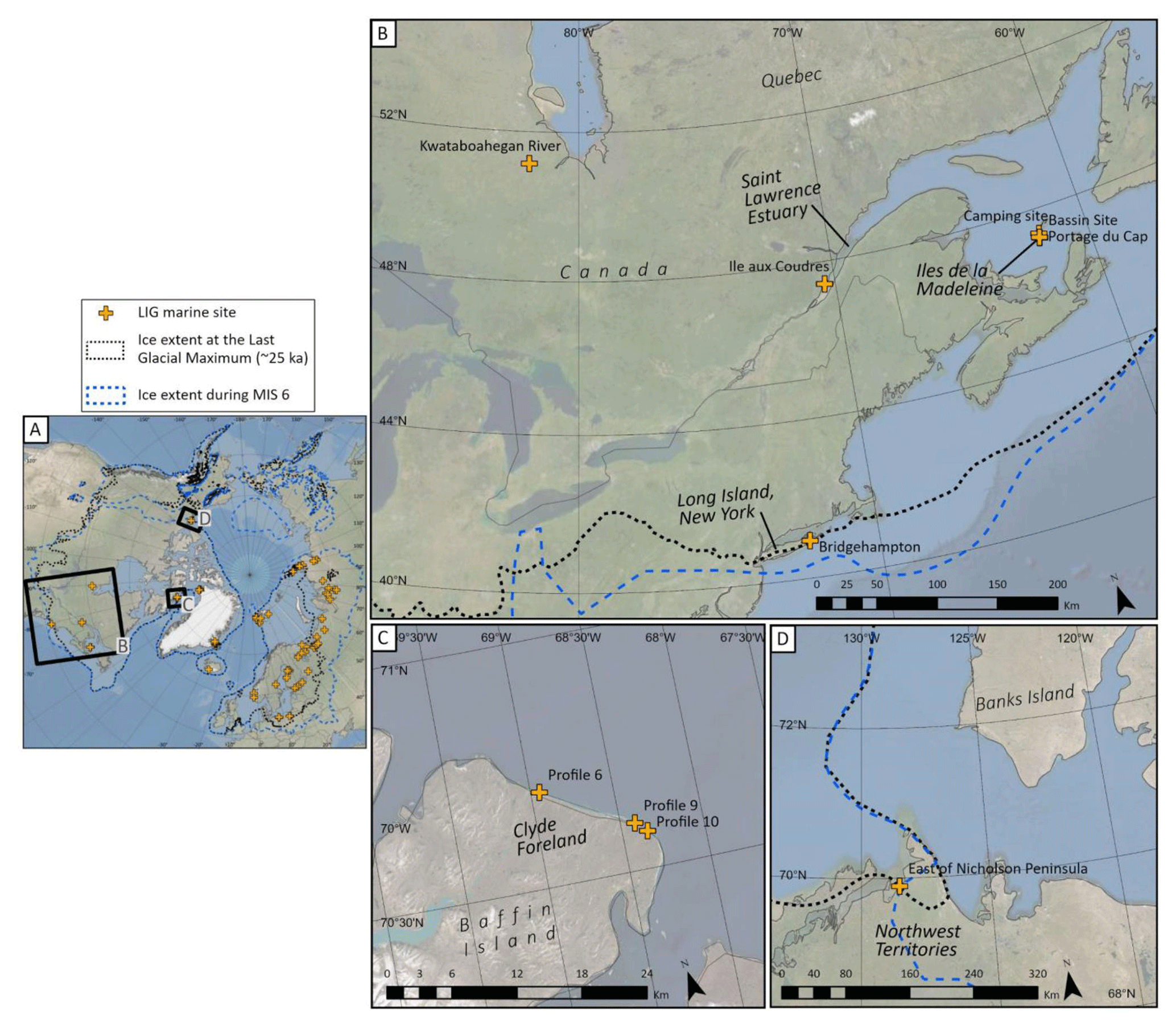
Figure 14The locations of LIG marine sites in North America. Panel (a) situates the sites in the Northern Hemisphere, whereas panels (b), (c) and (d) provide regional maps. Sites plotted on this map are detailed in Sect. 6.43–6.48. Extent of MIS 6 and Last Glacial Maximum ice sheets after Batchelor et al. (2019). Scale calculated at centre of mapped area. Base layer: ArcGIS World Imagery.
6.43.2 Portage du Cap
The Portage du Cap site (Fig. 14b) was first described by Prest et al. (1976) and subsequently by Dredge et al. (1992). At this site, a sequence of sub-till silts, pebbles and gravel are exposed within a gravel pit. The entire marine sequence spans 14–17 m a.s.l. (Dredge et al., 1992). Underlying the entire marine sequence is sandstone bedrock containing borings from Zirphaea sp., a species that lives in the modern intertidal zone in the region. The lowest unit, situated at 14 m a.s.l., is a grey marine silt, rich in dinoflagellate cysts, containing a pollen, beetle and diatom assemblage suggesting conditions warmer than the present day in the region (Dredge et al., 1992; Prest et al., 1976). Within this unit there are clast-supported beach gravels with well-rounded pebbles. Overlying the gravel unit is a 1–2 m-thick organic sand unit with a woody organic horizon. For this reason, the lowermost section of this stratigraphic sequence has been assigned to a LIG marine incursion that immediately followed the removal of MIS 6 ice from this area. On top of this unit is a gravel unit with a pollen assemblage similar to the present day, likely the result of relative climatic cooling following peak LIG conditions, paired with local sea-level rise and beach formation (Dredge et al., 1992). Three radiocarbon ages are available at this site. Plant detritus and wood have been dated to >38 and >35 ka (GSC-2313 and BGS-259; Prest et al., 1976) and a marine shell was dated to 42.9 ± 0.72 ka (GSC-4633 HP; McNeely and McCuaig, 1991). The finite age on the marine shell is possibly beyond the reliability limit for dating marine shells (Pigati, 2002), and all radiocarbon ages are considered minimum.
6.43.3 Le Bassin site
Dredge et al. (1992) described a stratigraphic section of sub-till peat overlain by clays, sands and gravels at the Bassin site, Iles de la Madeleine, Canada (Fig. 14b). At the base of the section overlying bedrock is a 0.5 m sand interval, followed by a 0.2 m peat layer. This was interpreted as formed in nearshore fluvial and lacustrine environments. Overlying the peat layer is a 0.9 m silt and clay unit, followed by 0.1 m of sand, both interpreted as marine in origin based on the presence of warm-water oyster shells (Ostrea virginica). The altitude of these marine sediments is unclear; we assume the base of the stratigraphic section is 0 m a.s.l. (“just below tide level” according to Dredge et al., 1992), which would situate the marine silt, clay and sands between 0.7 and 1.7 m a.s.l. Pollen data from these sediments suggest conditions similar to the present day (Mott and Grant, 1985). The sub-till sediments suggest that, following deglaciation of this region, the local area became a peatland and, as sea levels rose, it transitioned to a lagoon environment, with beach ridge and coastal barrier formation (Dredge et al., 1992). Three ages on these sediments range from 89 to 106 ka (UQT-182, UQT-183, UQT-184) and were interpreted as minimum age constraints by the original authors. Two diamictons (interpreted as tills deposited during ice advances) truncate the sand unit. Based on pollen and stratigraphic position, Dredge et al. (1992) suggested a LIG age assignment.
6.44 Clyde Foreland, Baffin Island, Canada (three sites)
First described by Løken (1966) and Feyling-Hanssen (1967), sub-till mollusc-bearing marine sands are present along cliffs of the Clyde Foreland, Baffin Island (Fig. 14c). These are known as the Cape Christian marine sediments. Several radiocarbon dating attempts on organic material from this unit yielded infinite ages or finite ages (e.g. QL-188) that can be considered minimum ages. Feyling-Hanssen (1967) suggested that these sediments were deposited during the LIG owing to its content of relatively warm-water-indicating foraminifera (Cassidulina teretis). Warm conditions were confirmed via pollen analyses. Later, these sites were re-visited by Miller et al. (1977), who reported a 230Th age of 130 ka. Below, we document three of these sites, as described by Miller et al. (1977). These sites are correlated with each other based on stratigraphic position and amino acid ratios.
6.44.1 Profile 6
Cape Christian marine sediments are situated between 27 and 28 m a.s.l. They are underlain by a series of sands and tills and overlain by a thin layer of buried soil along with till from later Pleistocene ice advance.
6.44.2 Profile 9
Cape Christian marine sediments (coarse sand and cobbles) are found between 9 and 11 m a.s.l. These marine sediments are overlain by two tills and younger marine sediments. This is the type section for the Cape Christine marine sediments.
6.44.3 Profile 10
Miller et al. (1977) documented coarse sands and gravels between 1.8 and 2.5 m a.s.l., which they correlate with the LIG Cape Christian marine sediments.
6.45 Isle-aux-Coudres, Quebec, Canada
Occhietti et al. (1995) described a core taken on Isle-aux-Coudres, located in the Saint Lawrence Estuary, Canada, that showing a succession of Pleistocene-aged deposits (Fig. 14b). A till was noted at the base of this record (known as the Baie-Saint-Paul glacial complex), followed by a series of clays, rhythmites and deltaic sediments, known as the “Guettard Sea” sediments, present from 125 to 2 m b.s.l. Occhietti et al. (1995) described, at the base of this stratigraphic unit, a very compact, finely stratified grey clay between 125 and 102 m b.s.l. A dinoflagellate cyst at 119 m b.s.l. suggests a marine origin for these sediments, and the authors interpreted it as a transgressive prodeltaic (deep marine) deposit. Next, between 102 and 71 m b.s.l., are grey rhythmites, hypothesized to be a high-level prodeltaic deposit resulting from the gradual shallowing of marine waters. Lastly, the sediment core shows silts and sandy silts between 71 and 2 m b.s.l., interpreted as prodeltaic, transitioning to deltaic sediments. This uppermost unit contains benthic foraminifera common to brackish marine water. Based on stratigraphic context (i.e. heavily isostatic depression following large-scale glaciation), Occhietti et al. (1995) aligned this record with the transition period between MIS 6 and the LIG. They inferred a large-scale, long-lasting glaciation followed by ice recession, rapid marine inundation into the isostatically depressed landscape, and shallowing of marine waters owing to subsequent rebound. This accumulation of marine sediments may represent 3.5 kyr of deposition (Occhietti et al., 1995). Since the age of the deposit is based on regional correlations and environmental conditions from pollen assemblage composition, rather than direct dating, we assign the lowest age quality score.
6.46 Bridgehampton, New York, United States
Marine sediments, typically sandy clay that is brown or grey/green in colour, were first encountered at depth on Long Island, New York in the early 1900s (Fuller, 1914; Fig. 14b). The so-called “Gardiners Clay” is present at depth in several borehole records between 20 and 45 m b.s.l. in various well records in this region (Nemickas and Koszalka, 1982). Palaeo-ontological work revealed a variety of warm-water fauna, including foraminifera, coelenterata, bryozoa and mollusca (Gustavson, 1972), confirming a marine origin for these sediments. At the Bridgehampton site, the Gardiners Clay was encountered between 23 and 46 m b.s.l. (Nemickas and Koszalka, 1982).
The Gardiners Clay is provisionally assigned to the LIG, based on stratigraphic context and amino acid dating. Stratigraphically, this marine unit is overlain by a series of Pleistocene deposits, notably the Montauk till, associated with the most recent (MIS 2) glaciation (Nemickas and Koszalka, 1982). Moreover, at some sites, the Gardiners Clay is underlain by a gravel deposit (Jameco Gravel; Fuller, 1914) that has been associated with fluvial or glaciofluvial deposition immediately following retreat of the MIS 6 ice sheet and prior to the marine incursion. The interpretation of the age is complicated by the fact that no amino acid racemization had been conducted on shells from the Bridgehampton site. However, shells contained in the Gardiners Clay from a nearby outcrop (40002; the stratigraphy of which was not described in detail) yielded an age assignment of early MIS 5 (Wehmiller et al., 1988; Wehmiller and Pellerito, 2015). The significant difference in elevation and depositional context (at depth in a drill core vs. sub-aerial outcrop) implies the Gardiners Clay might represent two marine deposits of different ages.
6.47 Kwataboahegan River, Ontario, Canada
The Hudson Bay Lowlands contain a rich stratigraphic record consisting of tills interspaced by non-glacial sediments. Along the Kwataboahegan River (Fig. 14b), in situ marine sediments were first discovered underlying till by Bell (1904), and later described in detail by Skinner (1973). These so-called “Bell Sea” sediments were first reported to be at 75 m a.s.l. (Skinner, 1973), however subsequent geochronological work on samples originally obtained by Skinner (1973) report the elevation as 90 m a.s.l. (McNeely, 2002). The reason for this discrepancy is unknown. These marine sediments consist of 0.8 m compact bluish grey sand and silt that are deformed owing to subsequent Wisconsinan ice advance over the region. An “undulating bed of marine mollusc shells” is present near the mid-point of the sediment package (Skinner, 1973).
The Bell Sea sediments are assigned to the LIG based on stratigraphic context, amino acid dating and minimum limiting radiocarbon ages. Stratigraphically, this marine deposit is overlain by tills that are assigned to the MIS 4 and MIS 2 glaciations. Amino acid dating also supports a LIG assignment for the Bell Sea sediments; Andrews et al. (1983) show that isoleucine epimerization ratios from shells in the Bell Sea sediments (average of ∼ 0.2) are significantly older than ratios from assumed mid-Wisconsinan marine deposits (∼ MIS 5–3) in this region (average of ∼ 0.14), which are even older than shells from the post-LGM marine incursion (average of ∼ 0.03). In calculating the amino acid dates, the average regional diagenetic temperature (0.6 ∘C) can only be reconciled with the isoleucine epimerization ratios if the smallest isoleucine epimerization ratio (Bell Sea sediments), is assigned to the LIG (Andrews et al., 1983). For that reason, the Bell Sea sediments were assigned to ∼ 130 ka (Andrews et al., 1983). Finally, two radiocarbon ages on marine shells (Hiatella arctica) from the Bell Sea deposit yielded >37 ka (GSC-1475; Blake, 1988) and 47.85 ± 1.09 ka (TO-2503; McNeely, 2002). The finite age is unreliable because shells samples are susceptible to modern-day contamination, and the date is very close to the limit of radiocarbon dating (McNeely, 2002). Thus, both are considered to be minimum limiting radiocarbon ages.
6.48 East of the Nicholson Peninsula, Northwest Territories, Canada
Along the westernmost coastline of the Northwest Territories, Canada, sediments representing the Liverpool Bay Interglaciation are exposed as part of the Ikpisugyuk Formation (Fig. 14d). As described by Rampton (1988), a layer of organic-bearing marine sand and silt is present between 0 and 2 m a.s.l. (Locality VH-83-050), which was interpreted as an intertidal beach complex. Fossils from a nearby exposure of the Ikpisugyuk Formation (VH-83-040; does not contain a marine unit) suggest a climate warmer-than-present, which supports LIG deposition (Rampton, 1988). Radiocarbon age attempts on driftwood contained in this unit were non-finite (GSC-3722) and amino acid ratios 0.1–0.15, both supporting a LIG age assignment based on the amino acid framework for nearby Banks Island (Vincent, 1982, 1983).
During our search for sites to include in this database, we located several LIG sites containing marine sediments that are not in situ, mostly due to post-depositional deformation and/or relocation. These sites are thus unsuitable as indicators of RSL but merit inclusion in this paper. We describe several such sites below, ordered east to west.
7.1 Lower Ob sites, West Siberian Plain, Russia
As shown in Fig. 4, the stratigraphic record present at the Lower Ob sites, West Siberian Plain, contains a well-dated LIG section consisting of alluvial sediment with OSL ages of 125–138 ka and thick peat with ages of 133 and 141 ka. These terrestrial sediments occur at the same altitudes or slightly higher than the corresponding marine sediments of the Arctic. However, marine sediments at the base of this stratigraphic sequence (separated from the overlying terrestrial beds by a till) yielded a youngest age of 153 ± 15 (sand with rich fauna of boreal foraminifers of the LIG assemblage in Hashgort borehole at lat/long 65.42, 65.67; Arkhipov et al., 1992). This marine unit possibly represents an earlier marine incursion and is therefore excluded from our database.
7.2 Pechora Lowland, Russia
At the More-Yu site, Pechora Lowland (lat/long 67.867, 60.183), OSL ages of 112 and 120 ka were obtained from large sand blocks with shells of boreal molluscs included into the glacially deformed diamict sequence (Fig. 3). The date of 130 ± 8 ka from this section on boreal Arctica islandica shell confirms a LIG age of the detached marine sand and a Weichselian age of the encompassing till with fossil glacial ice (Astakhov and Svendsen, 2002). We exclude this site from our database owing to the likely glacial translocation of the marine unit. Another site in the Pechora Lowland is Vastiansky Kon, which was first described in 1938 and revisited by Tveranger et al. (1998). The stratigraphic record, along with the presence of warmer-water marine shells, suggests a LIG age for marine sediments at this site. However, it has been glaciotectonized and is therefore inappropriate for inclusion in our database.
7.3 Malaya Kachkovka, Kola Peninsula, Russia
The Malaya Kachkovka site is in the tributary valley of the Malaya Kachkovka River on the eastern coast of the Kola Peninsula (lat/long 67.40, 40.90; 140 m a.s.l.). The entire sediment exposure is ∼ 10 m thick (Gudina and Yevzerov, 1973). The mollusc and foraminifera fauna, as well as the pollen content of a marine sediment interval between 127.5 and 134 m a.s.l. were studied by Lavrova (1960) and Gudina and Yevzerov (1973). The marine part of the section comprises a 0.5 m-thick clay unit at the base of the exposure, overlain by mollusc-bearing sands. Lavrova (1960) considered that the mollusc fauna contained in the sediments represents the upper sublittoral zone, and according to Gudina and Yevzerov (1973) the faunal assemblage represents the warmest fauna of interglacial marine sediment faunas discovered on the Kola Peninsula. Uranium–thorium ages on Astarte borealis shells from coarse and medium marine sands at around 132 m a.s.l. yielded ages of 102 ± 4 and 114 ± 4 ka (Arslanov et al., 1981), suggesting that the sediments were deposited during the LIG. However, Gudina and Yevzerov (1973) pointed out that the characteristics of the faunal assemblages and the high altitude of the marine sediments might suggest that they do not represent the LIG but rather an older interglacial. Even if this is not the case (i.e. from an earlier interglacial), the till on top of the marine sediments might indicate that the marine sequence is not in an in situ position and has been glacially thrust as a block to its present high-altitude position. The site is thus excluded from our LIG database.
7.4 Ludyanoi, Kola Peninsula, Russia
Grave et al. (1969) described a riverbank section of the Ludyanoi creek (lat/long 66.33, 39.92; 70 m a.s.l.), a small tributary to Pulonga River, south-eastern costal area of the Kola Peninsula. They described a sediment exposure where the top 10.7 m of the section is glaciofluvial sands and gravels overlying a 1.5 m-thick till. Below the till is a 3.7 m-thick greenish grey marine clay with shells and shell fragments recognized as Astarte borealis, A. elliptica, A. crenata and A. montaqui, of which the latter two are considered subarctic to their biogeography. The top of the marine clay unit is at around 60 m a.s.l., but it is not precisely known if this marine unit is in situ. It is therefore excluded from our database.
7.5 Lovozero, Kola Peninsula, Russia
There is a thick sediment sequence at the Lovozero site located in the inner part of the Kola Peninsula, Russia (lat/long 67.08, 38.970; 210 m a.s.l.). The lower part of the drill hole sections contains a 44 m-thick sand and silt unit between 140 and 184 m a.s.l. A proportion of the diatom flora in the lower part of the sediment core is marine and the pollen taxa is dominated with pine and birch (Ikonen and Ekman 2001). However, it is generally thought that diatoms and pollen are mostly reworked in this lower sand-rich sediment unit and therefore, the correlation of this unit with the LIG is not possible and the position of the sea level cannot be reconstructed (e.g. Ikonen and Ekman, 2001). We do not include the Lovozero site in our database.
7.6 Evijärvi, Finland
The Evijärvi site is situated in central Ostrobothnia, western Finland (lat/long 63.434, 23.322; 67 m a.s.l.). At this site, the LIG sediments occur on the proximal flank of a drumlin (Eriksson et al., 1980). In the top 6.4 m of the borehole record, several till and sand beds occur. The interglacial sediments consist of silt (9.0–9.5 m depth) and gyttja (6.4.–7.4 m depth) interbedded with till. Samples for pollen and diatoms were analysed from borehole sediments (Grönlund, 1991a; Eriksson, 1993). The pollen spectra of the silt layer (9.0–9.5 m depth) and gyttja layer (6.4–7.4 m depth) indicate only one local pollen assemblage zone consisting of Betula, Alnus, Picea and Corylus, which is correlated with the LIG (Erikson, 1993). Diatoms in the silt bed (9.0–9.5 depth) above the till at the base of the core are exclusively marine, while the diatom taxa in the gyttja are dominated by marine lagoonal types (Grönlund, 1991a). We do not include the Evijärvi site in our database because these LIG marine sediments are not at their original position of deposition but have been transported for an unknown distance and altitude by ice (e.g. Eriksson, 1993).
7.7 Norinkylä, Finland
The Norinkylä site is situated in southern Ostrobothnia, western Finland (lat/long 62.58, 22.020, 114 m a.s.l.). This site exposes till on top of the flanks of an esker, and in between are glacially deformed gyttja, organic-rich silt and sand, suggested to be LIG in age (Niemelä and Tynni, 1979; Donner, 1988). Boreholes made in the Rahkaneva mire next to the till-covered esker display silt, clay and gyttja in between two till beds with a maximum thickness of 4.5 m. The inter-till sediments have been studied for their lithology and pollen and diatom content (Grönlund, 1991b; Erikson, 1993). The pollen assemblage shows a succession typical for the LIG in western Finland (Eriksson, 1993). Freshwater diatom taxa dominate the lowermost part of the inter-till sediments (biostratigraphically belonging to the early LIG Betula regional zone; Grönlund, 1991b), while there is a transition to marine diatom taxa that takes place at around 97 m a.s.l. Saline diatom taxa dominate the interglacial sediment between 97 and 102 m a.s.l. (Grönlund, 1991a, b). We do not include the Norinkylä LIG sediments in our database because these sediments are glaciotectonized and have been transported an unknown distance from their original place of deposition.
7.8 Svartenhuk Halvø, western–central Greenland
Kelly (1986) and Bennike et al. (1994) describe a raised marine deposit in western–central Greenland, which was correlated with the LIG based on amino acid dating. They found no evidence of a Holocene highstand in this location. However, more recent work at this site suggests it may not have been deposited during the LIG (Lane et al., 2015). We were unable to add this site to the database as there was limited information on the elevation, geology and conflicting age constraints.
7.9 Nantucket, Massachusetts, United States
Marine sediments, bracketed by two tills, on Nantucket, Massachusetts, United States, were first described in the 1800s (Desor and Cabot, 1849; Verrill, 1875). These marine sediments are located between 0 and 20 m a.s.l. (Oldale et al., 1982). These sediments consist of a gravel base, overlain by several metres of cross-bedded so-called “Sankaty Sands” that contain stratified silt and clay along with abundant marine shells. Oldale et al. (1982) assigned the Sankaty Sands to the LIG based on stratigraphic context, palaeo-environmental data, absolute chronology (, minimum radiocarbon ages) and relative age determinations (amino acid racemization). The lowermost till was assigned to MIS 6 and the upper till to MIS 2 ice advances, and the Sankaty Sands were stratigraphically constrained to the time interval immediately following retreat of the MIS 6 ice sheet. Palaeo-environmentally, well-preserved warm-water oyster shells (Crassostrea virginica) and clam shells (Mercenaria mercenaria) are present at the base of this marine unit, and cooler-water clams (Mercenaria campechiensis) and mussels (Mytilus edulis) are present near the top (Verrill, 1875). These marine shells capture the transition from warm-water LIG conditions to more temperate MIS 5d conditions (Oldale et al., 1982). In terms of absolute chronology, corals located within the Sankaty Sands were dated via methods to 133 ± 7 ka, which the authors believed to be a maximum age for this deposit (SHIO/80-9; Oldale et al., 1982). Moreover, seven radiocarbon ages were obtained from wood and shells located at this site. Four yielded non-finite ages and three were finite. However, the latter were suspected of being affected by modern carbon contamination (Oldale et al., 1982). Finally, amino acid racemization analyses (isoleucine epimerization ratios) of 10 shells from this marine unit suggest deposition between 140 and 120 ka (Oldale et al., 1982). In summary, the palaeo-environmental data, stratigraphic context and available age assignments all suggest a LIG age for the Sankaty Sands. Despite the clear evidence of LIG age assignment, the section is glaciotectonized, and is therefore unreliable as an estimate of palaeo-sea level.
7.10 Western Banks Island, Canada
Lakeman and England (2014) describe a glaciotectonized marine deposit on Phillips Island, located off the western coast of Banks Island, which dated to the LIG based on OSL dates and non-finite radiocarbon dates. The exposure has interbedded sand, silt and clay with abundant mollusc fossils. The OSL samples were taken at 7 m a.s.l. Several other raised in situ marine deposits were sampled in western Banks Island but returned finite ages that would place the age of those deposits to MIS 3. They cautioned that the results from the Phillips Island OSL dates means that those radiocarbon dates may be minimum ages. If regarded in this way, these sites may be from the LIG, but the ambiguity means we have not added these sites to the database.
This paper brings together 82 LIG sea-level proxies from the formerly glaciated Northern Hemisphere. In general, the sites reported in this paper do not offer constraint on the global LIG highstand, but rather evidence of GIA-influenced sea-level positions after the end of the MIS 6 glaciation. The motivation behind some of the research described herein was to constrain the extent of the Barents Sea, and the (possible) connection between the White Sea and the Baltic Sea caused by the glacio-isostatic depression of western Russia during the MIS 6 glaciation and into the LIG (Ikonen and Ekman, 1991; Funder et al., 2002; Miettinen et al., 2014). Last Interglacial sites in Svalbard, Iceland and Greenland are largely located along the modern-day coastline. Comparatively fewer LIG sites are present in North America, likely owing to more glacial erosion or their sub-surface position in borehole records. Overall, LIG marine sites in the Northern Hemisphere have “poor”, “average” or “good” chronological constraints (ranks of 2, 3 or 4; see Table 5 and Fig. 15), due to conflicting geochronological data, a dependence on chronostratigraphic inference, large dating uncertainties and a fragmented stratigraphic record. The quality of RSL data is more varied, with some sites ranking very low (e.g. rank of 0 for the Kwataboahegan River site), and others very high (e.g. rank of 5 at the Fjøsanger and Bø sites; see Table 5 and Fig. 15).
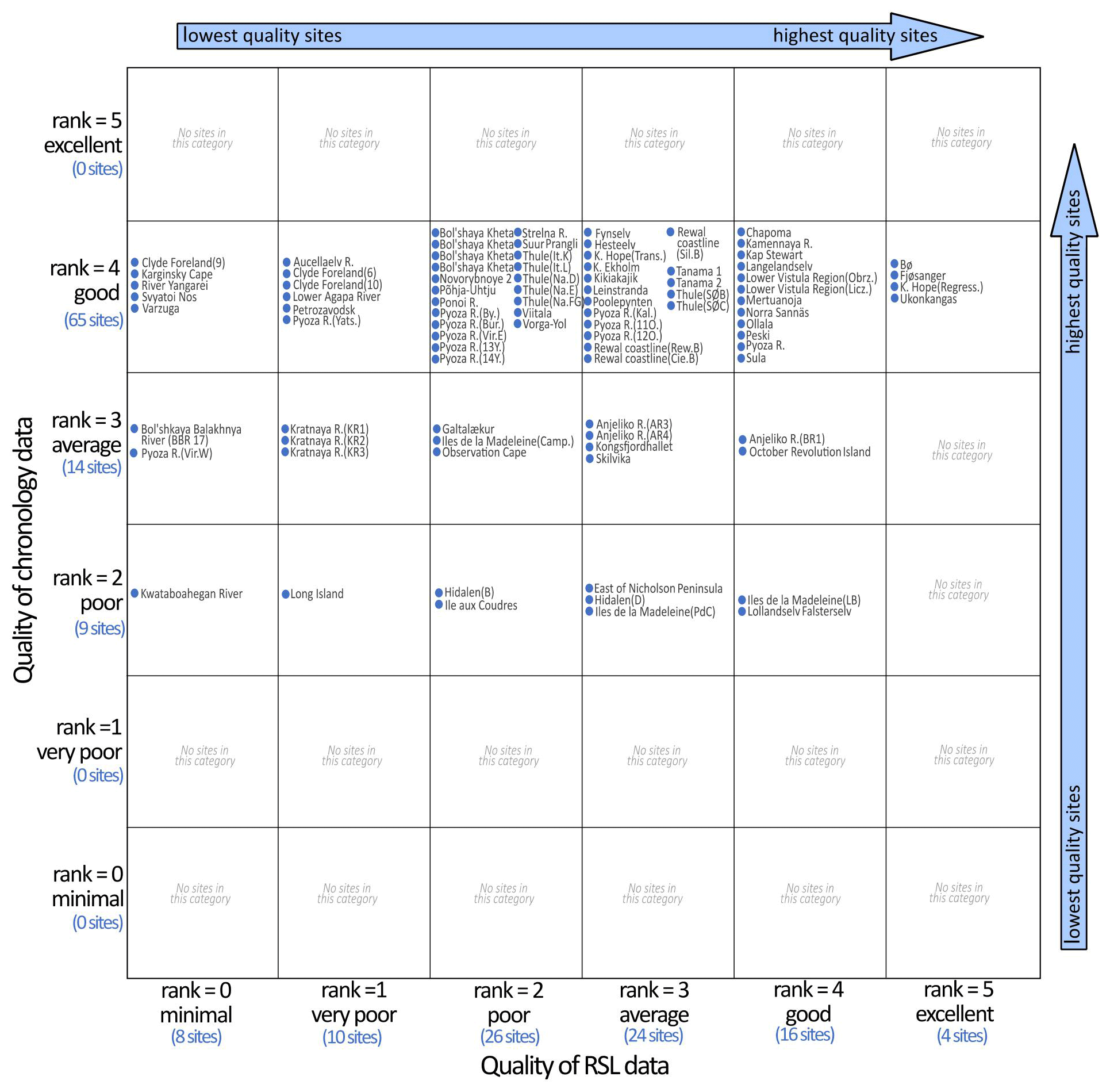
Figure 15Schematic diagram showing each site with quality scores for the RSL data (horizontal axis) and chronology data (vertical axis).
8.1 Pre- and post-LIG sea-level oscillations
Northern Hemisphere ice sheets waxed and waned many times during the Quaternary (Batchelor et al., 2019), allowing for marine incursions prior to the LIG (e.g. during MIS 7) and during later intervals (e.g. during MIS 5c, MIS 5a, MIS 3 and the Holocene), with maximum highstands preferentially during the transitional stages between glacials and following interglacials/interstadials. However, given difficulties inherent to dating sediments beyond the range of radiocarbon dating, chronological constraints remain a key challenge for these deposits. Here, we highlight some locations where pre-LIG and post-LIG sea-level oscillations are recorded. This list is not exhaustive; rather, it is meant to provide examples of other sea-level oscillations that are preserved in the stratigraphic record and to provide context for the difficulties in assigning ages to marine deposits in the glaciated Northern Hemisphere.
Several pre-LIG marine units have been described at Kongsfjordhallet, Svalbard (Houmark-Nielsen and Funder, 1999). The oldest marine unit is probably as much as 1 million years old. Marine sediments dating to MIS 7 have been documented at several sites in Russia. At the Bol'shaya Kheta River sections (lat/long 67.97, 83.10), in addition to LIG marine sediments (see Sect. 6.10), a lower marine bed contains shells of the extinct mollusk Cyrtodaria jenisseae Sachs (today generally considered to be Cyrtodaria angusta; see e.g. Möller et al., 2019a) and OSL ages at 225 ± 16, 226 ± 21, 162 ± 23, 231 ± 17 ka indicate a MIS 7 age (Nazarov et al., 2020; Astakhov and Semionova, 2021). A pre-LIG age is also suggested for numerous sites on the Taimyr Peninsula. Kind and Leonov (1982) claimed that >60 outcrops on central Taimyr Peninsula, south of Lake Taimyr, expose LIG-aged marine sediments. In the Bol´shaya Balakhnya river valley such sediment should reach 30–40 m a.s.l., while further to the north-east, in the Bol'shaya Rassokha River valley, such sediment should reach 60–70 m a.s.l. However, as demonstrated in Möller et al. (2019a) from a large number of sections along the Bol´shaya Balakhnya River, these sediments are of an older age as suggested from numerous ESR and OSL dates (Möller et al., 2019a, b). The sediments that Kind and Leonov (1982) presumed were LIG in age are often overlain by a till; as the sediment sections are south of the Severokokora ice marginal zone, marking the southern maximum boundary of the MIS 5d (known locally as the Early Zyryanka) glaciation over Taimyr (Möller et al., 2019a), this till must predate the MIS 5d glaciation (MIS 6 or older) and the marine sediments are consequently of a pre-LIG age.
Post-LIG marine sediments are far more commonly preserved in the stratigraphic record. For example, at the Chapoma site on the Kola Peninsula, in addition to LIG marine sediments (see Sect. 6.18), an upper marine silt is present between 11 and 13 m a.s.l. (Korsakova, 2019). Two ESR dates on shells at around 12 m a.s.l. in this marine unit yielded ages of 85.5 ± 3.2 and 86.0 ± 3.9 ka (Arslanov, 1981), placing it in MIS 5a. Multiple sea-level oscillations are also present at the Lower Agapa River sections (Gudina et al., 1968) as well as the Strelna River site (Sect. 6.19) where a sequence of upper marine sediments was dated via IRSL and ESR to between 102 and 84 ka (Korsakova et al., 2004; Korsakova, 2019). Möller et al. (2015, 2019a) describe several marine sequences in the central and southern parts of the Taimyr Peninsula, Russia. All these marine sediment successions were dated with ESR and OSL; with six outliers excluded the mean age is ∼ 86 ka (n=62) with an age scatter of ±15 ka, which firmly puts these sediments into MIS 5c–b (known locally as the Early Zyryanka). Finally, marine sediments at the Anjeliko River site (Sect. 6.5) have been constrained to an ESR age cluster of 80–93 ka (mean age 86 ka), suggesting deposition at marine inundation during MIS 5a following a Kara Sea Ice Sheet glaciation during MIS 5d–5c.
Marine sediments dating to MIS 3 have been described in the glaciated region of Russia and Europe. For example, at the Ozernaya River on October Revolution Island, offshore of Taimyr Peninsula (Sect. 6.6), Marine unit IV sediments were exposed in two sections on opposite sides of the river valley, ∼ 2.5 km apart (Oz 4 and Oz 5; Möller et al., 2007). These sediments contained a rhythmical sedimentation pattern, several in situ positioned paired mollusc shells and almost complete skeletons of at least nine narwhals (Monodon Monoceros) that were in the process of eroding out at the top of the sediment succession. The Marine IV sediments were interpreted as formed in a marine setting at a water level >65 m a.s.l. within a deeply embayed estuary behind a valley-mouth bar/barrier system in the Ozernaya valley (Möller et al., 2007). Radiocarbon dating of a narwhal tusk and molluscs yielded ages of ∼ 50, 45.4 and 46.8 ka (all at the upper limit of radiocarbon dating), ages supported by a single mollusc shell ESR dated to 59 ka. The dating of Marine IV sediments thus suggests that they are of a MIS 3 age, formed at a marine inundation of the island that probably was glaciated during the whole timespan of MIS 5d–4. Marine sediments dated to between the LIG and MIS 2 are widespread in Svalbard (Mangerud et al., 1998; Alexanderson et al., 2018). For example, at Kapp Ekholm (described in Sect. 6.35) there are two pre-Holocene marine units situated stratigraphically above the LIG beds, one considered to be of a MIS 5c age and the younger of MIS 3 age. Beds of basal till are found between these marine units.
Marine sediments dating to MIS 3 are uncommon in North America and are often less reliably constrained than similar sites in Russia and Europe. Nevertheless, shallow marine and beach sediments in Eastern Canada constrained to MIS 3, using OSL and radiocarbon dating, are situated at 30, 37 and ∼ 15 m a.s.l. (Rémillard et al., 2016, 2017). Also, in the Saint Lawrence Lowlands, marine sediments dated by radiocarbon to MIS 3 are situated at 30 m a.s.l. (Dionne and Occhietti, 1996). Finally, there is evidence of a marine incursion between the LIG and the Holocene in the Hudson Bay Lowlands, Canada (Severn River marine unit; 55 m a.s.l.). These marine sediments have been dated via amino acid techniques (Andrews et al., 1983), TL age attempts (Forman et al., 1987) and OSL attempts (Dalton et al., 2016). However, there is no clear consensus on the age of this marine incursion as most attempts spanned MIS 5a–3 and were of relatively low precision (e.g. ±10 ka).
8.2 Holocene sea-level databases
Holocene marine sediments are widely preserved in the glaciated Northern Hemisphere and are documented in several databases, including the Russian Arctic (Baranskaya et al., 2018), the Baltic Sea (Rosentau et al., 2021), European western coast (García-Artola et al., 2018), Greenland (Long et al., 2011) and eastern Canada (Vacchi et al., 2018).
The database on LIG sites in the glaciated Northern Hemisphere is available here: https://doi.org/10.5281/zenodo.5602212 (Dalton et al., 2021). A detailed description of database fields in the WALIS database is available here: https://doi.org/10.5281/zenodo.3961544 (Rovere et al., 2020).
Reconstructing sea-level change through the LIG is critical for understanding the sensitivity of the Earth system to future change. Here, we contribute 82 LIG sea-level proxies from the formerly glaciated Northern Hemisphere to the WALIS database. Given their position in the envelope of Northern Hemisphere ice sheets, these data are useful for testing the reliability of MIS 6 ice sheet reconstructions, and deducing LIG sea level. Obtaining an accurate chronology remains one of the most significant challenges for LIG deposits in the glaciated region. When geochronological data are lacking, often the only way to distinguish between interglacial deposits is via palaeo-ecological inferences, which have their own set of uncertainties. Therefore, key areas of future research should focus on revisiting these sites to vet the stratigraphic record and testing new geochronological methods (especially , OSL, and the potential for cosmogenic nuclide methods to constrain the age of buried sediments, e.g. Balco and Rovey, 2008). Future work to locate new LIG sites (particularly in North America, which has a relative scarcity of LIG sites) should be focussed on coastal regions that are known to contain extensive stratigraphic records (e.g. the Saint Lawrence valley).
ASD and EJG conceptualized this paper. ASD wrote the first draft with substantial input from JM, PM, JPL and VA. EJG managed data entry into the WALIS database and developed the methodological framework. All the authors reviewed/edited subsequent drafts of the manuscript.
The contact author has declared that neither they nor their co-authors have any competing interests.
The information contained in this database was the result of studies from
many scientists over the course of several decades. Please cite the original
sources of the data in addition to this database.
Publisher's note: Copernicus Publications remains neutral with regard to jurisdictional claims in published maps and institutional affiliations.
This article is part of the special issue “WALIS – the World Atlas of Last Interglacial Shorelines”. It is not associated with a conference.
Funding for Evan J. Gowan was provided through a Japan Society for the Promotion of Science Postdoctoral Fellowship, Helmholtz Exzellenznetzwerks “The Polar System and its Effects on the Ocean Floor (POSY)” and Helmholtz Climate Initiative REKLIM (Regional Climate Change), a joint research project at the Helmholtz Association of German research centres (HGF). Fieldwork for Jan Mangerud was funded by several consecutive grants from the Research Council of Norway. Specific project funding for research on Taimyr/Russia was provided through grants from the Swedish Natural Science Research Council (VR) to Per Möller (contract nos. G-650-199815671/2000 and 621-2008-3759) and logistics were mainly arranged and, to a large extent, funded by the Swedish Polar Research Secretariat (SPRS). Fieldwork for Juha P. Lunkka was funded by the Academy of Finland and the Finnish Academy of Science and Letters. Overview of Russian sites by Valery Astakhov was performed according to the research plan of the St. Petersburg State University, Russia. This study was also supported by the PACES-II program at the Alfred Wegener Institute and the Bundesministerium für Bildung und Forschung funded project, PalMod. The WALIS database was developed by the ERC Starting Grant “Warmcoasts” (ERC-StG-802414) and PALSEA. PALSEA is a working group of the International Union for Quaternary Sciences (INQUA) and Past Global Changes (PAGES), which in turn received support from the Swiss Academy of Sciences and the Chinese Academy of Sciences. The database structure was designed by Alessio Rovere, Deirdre Ryan, Thomas Lorscheid, Andrea Dutton, Peter Chutcharavan, Dominik Brill, Nathan Jankowski, Daniela Mueller, Melanie Bartz, Evan Gowan, and Kim Cohen. Thanks go to Svend Funder for helpful discussions as well as two anonymous reviewers.
This paper was edited by Alexander R. Simms and reviewed by two anonymous referees.
Alexanderson, H. and Landvik, J. Y.: Sediments of MIS 5e age suggested by new OSL dates from the Skilvika section, west Svalbard, Polar Res., 37, 1503907, https://doi.org/10.1080/17518369.2018.1503907, 2018.
Alexanderson, H., Landvik, J. Y., Molodkov, A., and Murray, A. S.: A multi-method approach to dating middle and late Quaternary high relative sea-level events on NW Svalbard – A case study, Quat. Geochronol., 6, 326–340, 2011a.
Alexanderson, H., Landvik, J. Y., and Ryen, H. T.: Chronology and styles of glaciation in an inter-fjord setting, northwestern Svalbard, Boreas, 40, 175–197, 2011b.
Alexanderson, H., Ingólfsson, Ó., Murray, A. S., and Dudek, J.: An interglacial polar bear and an early Weichselian glaciation at Poolepynten, western Svalbard, Boreas, 42, 532–543, 2013.
Alexanderson, H., Henriksen, M., Ryen, H. T., Landvik, J. Y., and Peterson, G.: 200 ka of glacial events in NW Svalbard: an emergence cycle facies model and regional correlations, Arktos, 4, 1–25, https://doi.org/10.1007/s41063-018-0037-z, 2018.
Andersen, B. G., Sejrup, H.-P., and Kirkhus, Ø.: Eemian and Weichselian Deposits at Bø on Karmøy, SW Norway: A Preliminary Report, Norg. Geol. Unders. B., 380, 189–201, 1983.
Andersson, T., Forman, S. L., Ingólfsson, Ó., and Manley, W. F.: Late Quaternary environmental history of central Prins Karls Forland, western Svalbard, Boreas, 28, 292–307, 1999.
Andrews, J. T., Shilts, W. W., and Miller, G. H.: Multiple deglaciations of the Hudson Bay Lowlands, Canada, since deposition of the Missinaibi (Last-Interglacial?) Formation, Quaternary Res., 19, 18–37, 1983.
Apukhtin, N. I.: Novye dannye po stratigraphii chetvertichnykh otlozheniy yuzhnoy chasti Kolskogo poluostrova [New data on Quaternary stratigraphy of the southeastern part of the Kola Peninsula]. Trudy VSEGEI, Leningrad: chetvertisnaya geologiya i geomorfologiya, in: Proceeding of the All-Russian Geological Institute: Quaternary Geology and Geomorphology, vol. 297, pp. 53–65, https://www.vsegei.ru/en/ (last access: 29 March 2022), 1978 (in Russian).
Arkhipov, S. A.: A chronostratigraphic scale of the glacial Pleistocene of the West Siberian North, in: Pleistotsen Sibiri. Stratigrafia i mezhregionalnye korrelatsii, edited by: Skabichevskaya, N. A., Nauka, Novosibirsk, 19–30, 1989.
Arkhipov, S. A., Levchuk, L. K., and Shelkoplyas, V. N.: Marine Quaternary sediments of the Lower Ob, in: Geokhronologia chetvertichnogo perioda, edited by: Murzayeva, V. E., Punning, J.-M. K., and Chichagova, O. A., Nauka, Moscow, 90–101, 1992.
Arslanov, K., Yevzerov, V. Y., Tertichnyi, N. I., Gerasimov, S. A., and Lokshin, N. V.: K voprosu o vozraste otlozhenii borealnoi transgressii (ponoiskikh sloev) na Kolskom poluostrove [On the age of deposits (Ponoi Beds) Boreal transgression in the Kola Peninsula], in: Pleistotsenovye Oledeneniya Vostochno-Evropeiskoi Ravniny [Pleistocene Glaciations on the East European Plain], edited by: Velichko, A. A. and Faustova, M. A., Nauka Press, Moscow, 28–37, 1981 (in Russian).
Astakhov, V. and Nazarov, D. V.: Stratigraphy of the Upper Pleistocene in northern West Siberia and its geochronometric foundation, Regionalnaya Geologia i Metallogenia, 43, 36–47, 2010a (in Russian).
Astakhov, V. and Nazarov, D. V.: Correlation of Upper Pleistocene sediments in northern West Siberia, Quaternary Sci. Rev., 29, 3616–3629, 2010b.
Astakhov, V. I.: Pleistocene glaciations of northern Russia – a modern view, Boreas, 42, 1–24, https://doi.org/10.1111/j.1502-3885.2012.00269.x, 2013.
Astakhov, V. I. and Semionova, L.: The penultimate interglaciation of northern Russia, Quatern. Int., 605–606, 142–154, 2021.
Astakhov, V. I. and Svendsen, J. I.: Age of remnants of a Pleistocene glacier in Bol`shezemel`skaya Tundra, Dokl. Earth Sci., 384, 468–472, translated from Doklady Akademii Nauk, 384, 534–538, 2002.
Astakhov, V. I., Arslanov, K. A., and Nazarov, D. V.: The age of mammoth fauna on the Lower Ob, Dokl. Earth Sci., 396, 538–542, translated from Doklady Akademii Nauk, 396, 253–257, 2004.
Astakhov, V. I., Arslanov, K. A., Maksimov, F. E., Kuznetsov, V. Y., Razina, V. V., and Nazarov, D. V.: The age of interglacial peat on the Lower Ob, Dokl. Earth Sci., 401, 298–302, translated from Doklady Akademii Nauk, 2005, 400, 95–99, 2005.
Balco, G. and Rovey, C. W: An isochron method for cosmogenic nuclide dating of buried soils and sediments, Am. J. Sci., 308, 1083–1114, 2008.
Baranskaya, A. V., Khan, N. S., Romanenko, F. A., Roy, K., Peltier, W. R., and Horton, B. P.: A postglacial relative sea-level database for the Russian Arctic coast, Quaternary Sci. Rev., 199, 188–205, 2018.
Batchelor, C. L., Margold, M., Krapp, M., Murton, D. K., Dalton, A. S., Gibbard, P. L., Stokes, C. R., Murton, J. B., and Manica, A.: The configuration of Northern Hemisphere ice sheets through the Quaternary, Nat. Commun., 10, 3713, https://doi.org/10.1038/s41467-019-11601-2, 2019.
Bell, J. M.: Economic Resources of Moose River Basin, Report of the Bureau of Mines Part I, 1904, 135–191, 1904.
Bennike, O., Hansen, K. B., Knudsen, K. L., Penney, D. N., and Rasmussen, K. L.: Quaternary marine stratigraphy and geochronology in central West Greenland, Boreas, 23, 194–215, 1994.
Bergsten, H., Andersson, T., and Ingólfsson, Ó.: Foraminiferal stratigraphy of raised marine deposits, representing isotope stage 5, Prins Karls Forland, western Svalbard, Polar Res., 17, 81–89, 1998.
Blake, W. J.: Geological Survey of Canada Radiocarbon Dates XXVII, Geological Survey of Canada, Paper 87–7, 100, https://doi.org/10.4095/126099, 1988.
Bolshiyanov, D. Y. and Makeyev, V. M.: Archipelago of Severnaya Zemlya: Environmental History, Gidrometeoizdat, St. Petersburg, 1995.
Boulton, G. S.: Glacial history of the Spitsbergen archipelago and the problem of a Barents Shelf ice sheet, Boreas, 8, 31–57, 1979.
Clay, P. L., Busemann, H., Sherlock, S. C., Barry, T. L., Kelley, S. P., and McGarvie, D. W.: ages and residual volatile contents in degassed subaerial and subglacial glassy volcanic rocks from Iceland, Chem. Geol., 403, 99–110, 2015.
Cohen, K. M., Cartelle, V., Barnett, R., Busschers, F. S., and Barlow, N. L. M.: Last Interglacial sea-level data points from Northwest Europe, Earth Syst. Sci. Data Discuss. [preprint], https://doi.org/10.5194/essd-2021-390, in review, 2021.
Dahl-Jensen, D., Albert, M. R., Aldahan, A., Azuma, N., Balslev-Clausen, D., Baumgartner, M., Berggren, A. M., Bigler, M., Binder, T., Blunier, T., Bourgeois, J. C., Brook, E. J., Buchardt, S. L., Buizert, C., Capron, E., Chappellaz, J., Chung, J., Clausen, H. B., Cvijanovic, I., Davies, S. M., Ditlevsen, P., Eicher, O., Fischer, H., Fisher, D. A., Fleet, L. G., Gfeller, G., Gkinis, V., Gogineni, S., Goto-Azuma, K., Grinsted, A., Gudlaugsdottir, H., Guillevic, M., Hansen, S. B., Hansson, M., Hirabayashi, M., Hong, S., Hur, S. D., Huybrechts, P., Hvidberg, C. S., Iizuka, Y., Jenk, T., Johnsen, S. J., Jones, T. R., Jouzel, J., Karlsson, N. B., Kawamura, K., Keegan, K., Kettner, E., Kipfstuhl, S., Kjær, H. A., Koutnik, M., Kuramoto, T., Köhler, P., Laepple, T., Landais, A., Langen, P. L., Larsen, L. B., Leuenberger, D., Leuenberger, M., Leuschen, C., Li, J., Lipenkov, V., Martinerie, P., Maselli, O. J., Masson-Delmotte, V., McConnell, J. R., Miller, H., Mini, O., Miyamoto, A.,Montagnat-Rentier, M., Mulvaney, R., Muscheler, R., Orsi, A. J., Paden, J., Panton, C., Pattyn, F., Petit, J. R., Pol, K., Popp, T., Possnert, G., Prié, F., Prokopiou, M., Quiquet, A., Rasmussen, S. O., Raynaud, D., Ren, J., Reutenauer, C., Ritz, C., Röckmann, T., Rosen, J. L., Rubino, M., Rybak, O., Samyn, D., Sapart, C. J., Schilt, A., Schmidt, A. M. Z., Schwander, J., Schüpbach, S., Seierstad, I., Severinghaus, J. P., Sheldon, S., Simonsen, S. B., Sjolte, J., Solgaard, A. M., Sowers, T., Sperlich, P., Steen-Larsen, H. C., Steffen, K., Steffensen, J. P., Steinhage, D., Stocker, T. F., Stowasser, C., Sturevik, A. S., Sturges, W. T., Sveinbjörnsdottir, A., Svensson, A., Tison, J. L., Uetake, J., Vallelonga, P., van de Wal, R. S. W., van der Wel, G., Vaughn, B. H., Vinther, B., Waddington, E., Wegner, A., Weikusat, I., White, J. W. C., Wilhelms, F., Winstrup, M., Witrant, E., Wolff, E. W., Xiao, C., and Zheng, J.: Eemian interglacial reconstructed from a Greenland folded ice core, Nature, 493, 489–494, 2013.
Dalton, A. S., Finkelstein, S. A., Barnett, P. J., and Forman, S. L.: Constraining the Late Pleistocene history of the Laurentide Ice Sheet by dating the Missinaibi Formation, Hudson Bay Lowlands, Canada, Quaternary Sci. Rev., 146, 288–299, 2016.
Dalton, A. S., Gowan, E. J., Mangerud, J., Möller, P., Lunkka, J. P., and Astakhov V.: Last interglacial (MIS 5e) sea level proxies in the glaciated Northern Hemisphere (1.0), Zenodo [data set], https://doi.org/10.5281/zenodo.5602212, 2021.
Davies, S. M., Abbott, P. M., Meara, R. H., Pearce, N. J. G., Austin, W. E. N., Chapman, M. R., Svensson, A., Bigler, M., Rasmussen, T. L., Rasmussen, S. O., and Farmer, E. J.: A North Atlantic tephrostratigraphical framework for 130–60 ka b2k: new tephra discoveries, marine-based correlations, and future challenges, Quaternary Sci. Rev., 106, 101–121, 2014.
Der Sarkissian, C., Möller, P., Hofman, C. A., Ilsøe, P., Rick, T. C., Schiøtte, T., Sørensen, M. V., Dalén, L., and Orlando, L.: Unveiling the ecological applications of ancient DNA from mollusk shells, Front. Ecol. Evol., 8, https://doi.org/10.3389/fevo.2020.00037, 2020.
Desor, M. E. and Cabot, E. C.: On the Tertiary and more recent deposits in the Island of Nantucket, Geological Society of London Quarterly Journal, 5, 340–344, 1849.
Devyatova, E. I.: Late Pleistocene Environments as Related to Human Migrations in the Dvina River Basin and in Karelia, Karelia, Petrozavodsk, 156 pp., 1982 (in Russian).
Devyatova, E. I. and Loseva, E. I.: Stratigraphy and Palaeogeography of the Quaternary Period in the Mezen River Basin, Akademiya Nauk SSSR, Izdalstoo Nauka, Leningrad, 105 pp., 1964 (in Russian).
Dionne, J.-C. and Occhietti, S.: Aperçu du Quaternaire à l'embouchure du Saguenay, Québec, Geogr. Phys. Quatern., 50, 5–34, 1996.
Donner, J.: The Eemian site of Norinkylä compared with other interglacial and interstadial sites in Ostrobothnia, Western Finland, Annales Academiae Scientiarum Fennicae A III, 149, 31, ISBN 9789514105609, 1988.
Douka, K., Higham, T. F. G., and Hedges, R. E. M.: Radiocarbon dating of shell carbonates: old problems and new solutions, Munibe Suplemento, 31, 18–27, 2010.
Dredge, L. A., Mott, R. J., and Grant, D. R.: Quaternary stratigraphy, paleoecology, and glacial geology, Îles de la Madeleine, Quebec, Can. J. Earth Sci., 29, 1981–1996, 1992.
Duller, G. A. T.: Single-grain optical dating of Quaternary sediments: why aliquot size matters in luminescence dating, Boreas, 37, 589–612, 2008.
Dutton, A. and Lambeck, K.: Ice Volume and Sea Level During the Last Interglacial, Science, 337, 216–219, 2012.
Dyer, B., Austermann, J., D'Andrea, W. J., Creel, R. C., Sandstrom, M. R., Cashman, M., Rovere, A., and Raymo, M. E.: Sea-level trends across The Bahamas constrain peak last interglacial ice melt, P. Natl. Acad. Sci. USA, 118, e2026839118, https://doi.org/10.1073/pnas.2026839118, 2021.
Eccleshall, S. V., Hormes, A., Hovland, A., and Preusser, F.: Constraining the chronology of Pleistocene glaciations on Svalbard: Kapp Ekholm re-visited, Boreas, 45, 790–803, 2016.
Eriksson, B.: The Eemian pollen stratigraphy and vegetational history of Ostrobothnia, Finland, Bulletin of the Geological Survey of Finland, 372, 36 pp., ISBN 951-690-519-6, ISSN 0367-522X, 1993.
Eriksson, B., Grönlund, T., and Kujansuu, R.: Interglasiaalikerrostuma Evijärvellä, Pohjanmaalla (An interglacial deposit at Evijärvi, in the Pohjanmaa region, Finland), Geologi, 32, 65–71, 1980 (in Finnish with English summary).
Eriksson, B., Grönlund, T., and Uutela A.: Biostratigraphy of Eemian sediments at Mertuanoja, Pohjanmaa (Ostrobothnia), western Finland, Boreas, 28, 274–291, 1999.
Feyling-Hanssen, R. W.: The Clyde Foreland, Field Report North-Central Baffin Island 1966, Department of Energy, Mines & Resources, Geographic Branch, Ottawa, 35–55, 1967.
Field, M. H., Huntley, B., and Müller, H.: Eemian climate fluctuations observed in a European pollen record, Nature, 371, 779–783, 1994.
Flude, S., Burgess, R., and McGarvie, D. W.: Silicic volcanism at Ljósufjöll, Iceland: Insights into evolution and eruptive history from Ar–Ar dating, J. Volcanol. Geotherm. Res., 169, 154–175, 2008.
Forman, S. L.: Post-glacial relative sea-level history of northwestern Spitsbergen, Svalbard, Geol. Soc. Am. Bull., 102, 1580–1590, 1990.
Forman, S. L.: Infrared and Red Stimulated Luminescence Dating of Late Quaternary Nearshore Sediments from Spitsbergen, Svalbard, Arct. Antarct. Alp. Res., 31, 34–49, 1999.
Forman, S. L., Wintle, A. G., Thorleifson, L. H., and Wyatt P. H.: Thermoluminescence properties and age estimates for Quaternary raised marine sediments, Hudson Bay Lowland, Canada, Can. J. Earth Sci., 24, 2405–2411, 1987.
Forsström, L. and Punkari, M.: Initiation of the last glaciation in northern Europe, Quaternary Sci. Rev., 16, 1197–1215, 1997.
Forsström, L., Eronen, M., and Grönlund, T.: On marine phases and shoreline levels of the Eemian interglacial and Weichselian interstadials on the coast of Ostrobothnia, Finland, Geol. S. Finl., 2, 37–42, 1987.
Forsström L., Aalto M., Eronen M., and Grönlund T.: Stratigraphic evidence for Eemian crustal movements and relative sea-level changes in eastern Fennoscandia, Palaeogeogr. Palaeoclimatol. Palaeoecol., 68, 317–335, 1988.
Fuller, M. L.: The geology of Long Island, New York, U. S. Geological Survey Professional Paper, 82, 1914, 231 pp., https://doi.org/10.3133/pp82, 1914.
Funder, S., Demidov, I., and Yelovicheva, Y.: Hydrography and mollusc faunas of the Baltic and the White Sea–North Sea seaway in the Eemian, Palaeogeogr. Palaeoclimatol. Palaeoecol., 184, 275–304, 2002.
García-Artola, A., Stéphan, P., Cearreta, A. Kopp, R. E., Khan, N. S., and Horton, B. P.: Holocene sea-level database from the Atlantic coast of Europe, Quaternary Sci. Rev., 196, 177–192, 2018.
Godfrey-Smith, D. I., Huntley, D. J., and Chen, W. H.: Optical dating studies of quartz and feldspar sediment extracts, Quaternary Sci. Rev., 7, 373–380, 1988.
Grave, M. K., Gunova, V. S., Devyatova, E. I., Lavrova, M. A., Lebedeva, R. M., Samsonova, L. Y., and Cheremisinova, E. A.: Mikulinskoye mezhlednikoviye na yugo-vostoke Kolskogo poluostrova [Mikulinian interglacial in the southeastern Kola Peninsula], in: Main Problems of Geomorphology and Anthropogen Stratigraphy of the Kola Peninsula, edited by: Grave, M. K. and Koshechkin, B. I., Nauka Press, Leningrad, pp. 25–56, 1969 (in Russian).
Grönlund, T.: The diatom stratigraphy of the Eemian Baltic Sea on the basis of sediment discoveries in Ostrobothnia, Finland, Geological Survey of Finland, Report of Investigation, 112, 26 pp., ISBN 951-690-418-1, ISSN 0781-4240, 1991a.
Grönlund, T.: New Cores from Eemian interglacial deposits in Ostrobothnia, Finland, Geological Survey of Finland Bulletin, 352, 31 pp., ISBN 951-690-417-3, ISSN 0367-522-X, 1991b.
Grøsfjeld, K., Funder, S., Seidenkrantz, M. S., and Glaister, C.: Last Interglacial marine environments in the White Sea region, northwestern Russia, Boreas, 35, 493–520, 2006.
Grün, R.: Electron spin resonance (ESR) dating, Quatern. Int., 1, 65–109, 1989.
Gudina, V. I. and Yevzerov, V. Y.: The Stratigraphy and Foraminifera of the Upper Pleistocene in the Kola Peninsula, translated by: Lees, E., edited by: Hughes, M., The British Library Board, ISBN 853501815, https://doi.org/10.1017/S0016756800026224, 1973.
Gudina, V. I., Nuzhdina, N. A., and Troitskiy, S. L.: New data on the marine Pleistocene of the Taymyr Lowland, Akademiya Nauk SSSR, Sibirskoe Otdelenie, Geologia i Geofizika, 40–48, 1968 (in Russian).
Gudina, V. I., Kryukov, V. D., Levchuk, L. K., and Sudkov, L. A.: Upper-Pleistocene sediments in north-eastern Taymyr, Bulletin of Commission on Quaternary Researches, 52, 90–97, 1983 (in Russian).
Gustavson, T. C.: A Warm-Water Pleistocene Fauna from the Gardiners Clay of Eastern Long Island, J. Paleontol., 46, 447–449, 1972.
Hansen, L. A., Ørgensen, M. E., Houmark-Nielsen, M., and Kronborg, C.: Late Pleistocene stratigraphy and depositional environments of the Fynselv area, Jameson Land, East Greenland, Boreas, 23, 385–397, 1994.
Head, M. J., Seidenkrantz, M.-S., Janczyk-Kopikowa, Z., Marks, L., and Gibbard, P. L.: Last Interglacial (Eemian) hydrographic conditions in the southeastern Baltic Sea, NE Europe, based on dinoflagellate cysts, Quatern. Int., 130, 3–30, 2005.
Høeg, H. I.: Pollenanalytiske undersøkelser i Rogaland og Ersdal i Vest-Agder [Pollen analytical investigations in Rogaland and in Ersdal in Vest-Agder], Artikkelsamling til Kerstin Griffin på 60-arsdagen [Museum landscape. A collection of papers for the 60th birthday of Kerstin Griffin], AmS-Rapport 12A, 145–226, 1999.
Houmark-Nielsen, M. and Funder, S.: Pleistocene stratigraphy of Kongsfjordhallet, Spitsbergen, Svalbard, Polar Res., 18, 39–50, 1999.
Houmark-Nielsen, M., Demidov, I., Funder, S., Grøsfjeld, K., Kjær, K. H., Larsen, E., Lavrova, N., Lyså, A., and Nielsen, J. K.: Early and Middle Valdaian glaciations, ice-dammed lakes and periglacial interstadials in northwest Russia: new evidence from the Pyoza River area, Global Planet. Change, 31, 215–237, 2001.
Huntley, D. J., Godfrey-Smith, D. I., and Thewalt, M. L. W.: Optical dating of sediments, Nature, 313, 105–107, 1985.
Hütt, G., Punning, J.-M., and Mangerud, J.: Thermoluminescence dating of the Eemian-Early Weichselian sequence at Fjøsanger, western Norway, Boreas, 12, 227–231, 1983.
Hütt, G., Molodkov, A., Kessel, H., and Raukas, A.: ESR dating of subfossil Holocene shells in Estonia, Nucl. Tracks Radiat. Meas., 10, 891–898, 1985.
Ikonen, L. and Ekman, I.: Biostratigraphy of the Mikulino interglacial sediments in NW Russia: the Petrozavodsk site and a literature review, Annales Academiae Scientiarum Fennicae A III Geologica-Geographica, 161, 88 pp., ISBN 978-9514109065, 2001.
Ingólfsson, Ó. and Wiig, Ø.: Late Pleistocene fossil find in Svalbard: the oldest remains of a polar bear (Ursus maritimus Phipps, 1744) ever discovered, Polar Res., 28, 455–462, 2009.
Ingólfsson, Ó., Lyså, A., Funder, S., Möller, P., and Björck, S.: Late Quaternary glacial history of the central west coast of Jameson Land, East Greenland, Boreas, 23, 447–458, 1994.
Ingólfsson, Ó., Rögnvaldsson, F., Bergsten, H., Hedenäs, L., Lemdahl, G., Lirio, J. M., and Sejrup, H. P.: Late Quaternary glacial and environmental history of Kongsøya, Svalbard, Polar Res., 14, 123–139, 1995.
Israelson, C., Funder, S., and Kelly, M.: The Aucellaelv stade at Aucellaelv, the first Weichselian glacier advance in Scoresby Sund, East Greenland, Boreas, 23, 424–431, 1994.
Janczyk-Kopikowa, Z. and Marks, L.: Eemian marine sediments in Poland, Unpublished Report, Polish Geological Institute, Warsaw University, Warsaw, 2002, 5, http://www.pgi.gov.pl/en/ (last access: 29 March 2022), 2002.
Katzenberger, O. and Grün, R.: ESR-dating of circumarctic molluscs, Nuclear Tracks, 10, 885–890, 1985.
Kelly, M.: Quaternary pre-Holocene marine events of western Greenland, Rapport Grønlands Geologiske Undersøgelse, 131, 1–23, ISSN 0418-6559, 1986.
Kelly, M., Funder, S., Houmark-Nielsen, M., Knudsen, K., L., Kronborg, C., Landvik, J., and Sorby, L.: Quaternary glacial and marine environmental history of northwest Greenland: a review and reappraisal, Quaternary Sci. Rev., 18, 373–392, 1999.
Kind, N. V.: Geokhronologia pozdniego antropogena po izotopnym dannym [Late Quaternary geochchronology according to isotope data], Moscow, Nauka, 255 pp., 1974 (in Russian).
Kind, N. V. and Leonov, B. N.: Antropogen Taimyra (The Anthropogene of Taymyr Peninsula), Nauka, Moscow, 1982.
Knudsen, K. L., Jiang, H., Gibbard, P. L., Kristensen, P., Seidenkrantz, M.-S., Janczyk-Kopikowa, Z., and Marks, L.: Environmental reconstructions of Eemian Stage interglacial marine records in the Lower Vistula area, southern Baltic Sea, Boreas, 41, 209–234, 2012.
Korsakova, O. P.: Pleistocene marine deposits in the coastal areas of Kola Peninsula (Russia), Quatern. Int., 206, 3–15, 2009.
Korsakova, O.: Formal stratigraphy of the Neopleistocene (Middle and Upper/Late Pleiostocene) in the Kola region, NW Russia, Quatern. Int., 534, 42–59, 2019.
Korsakova, O.: Upper Pleistocene and Holocene stratigraphy in the Kola Peninsula and Northern Karelia (N–W Russia): Marine and glacial units, Quatern. Int., 605–606, 108–125, 2021.
Korsakova, O. P., Molodkov, A. N., and Kolka, V. V.: Geological-stratigraphic position of Upper Pleistocene marine sediments in the Southern Kola Peninsula: evidence from geochronological and geological data, Dokl. Earth Sci., 398, 908–912, 2004.
Korsakova, O., Kolka, V., and Semenova, L.: Late Pleistocene stratigraphy according to the sediments sequence from eastern Kola Peninsula, Ponoi Ricer Valley (North-Western Russia), Quatern. Int., 420, 280–293, 2016.
Krzymińska, J.: Analiza mikrofauny i malakofauny z osadów strefy brzegowej – czesc zachodnia, Arch. Oddz. Geologii Morza, PIG-PIB, Gdañsk, 1996.
Krzyszkowski, D.: Till stratigraphy, petrography and palaeogeography along the northwestern coastal region of Poland, Biuletyn pañstwowego instytutu geologicznego, 438, 51–92, 2010.
Krzyszkowski, D., Dobracka, E., Dobracki, R., Czerwonka, J. A., and Kuszell, T.: Stratigraphy of Weichselian deposits in the cliff sections between Lukecin and Niechorze, Baltic Coast, northwestern Poland, Quaternary Studies in Poland, 16, 27–45, 1999.
Lakeman, T. R. and England, J. H.: Late Wisconsinan glaciation and postglacial relative sea-level change on western Banks Island, Canadian Arctic Archipelago, Quaternary Res., 80, 99–112, 2014.
Lambeck, K., Purcell, A., Funder, S., Kjær, K. H., Larsen, E., and Möller, P.: Constraints on the Late Saalian to early Middle Weichselian ice sheet of Eurasia from field data and rebound modelling, Boreas, 35, 539–575, 2006.
Lamothe, M. and Huntley, D. J.: Thermoluminescence Dating of Late Pleistocene Sediments, St. Lawrence Lowland, Québec, Geogr. Phys. Quatern., 42, 33–44, https://doi.org/10.7202/032707ar, 1988.
Landvik, J. Y., Bolstad, M., Lycke, A. K., Mangerud, J., and Sejrup, H. P.: Weichselian stratigraphy and palaeoenvironments at Bellsund, western Svalbard, Boreas, 21, 335–358, 1992.
Landvik, J. Y., Lyså, A., Funder, S., and Kelly, M.: The Eemian and Weichselian stratigraphy of the Langelandselv area, Jameson Land, East Greenland, Boreas, 23, 412–423, 1994.
Lane, T. P., Roberts, D. H., Ó Cofaigh, C., Vieli, A., and Moreton, S. G.: The glacial history of the southern Svartenhuk Halvø, West Greenland, Arktos, 1, 19, https://doi.org/10.1007/s41063-015-0017-5, 2015.
Lavrova, M. A.: On the interglacial marine transgressions of the Pechora region, Uchonye zapiski, Leningrad University, Series Geography, 124, 14–51, 1949 (in Russian).
Lavrova, M. A.: Chetvertichnaya Geologiya Kolskogo Poluostrova [Quaternary Geology of the Kola Peninsula], Academy of Sciences of USSR Press, Moscow-Leningrad, 1960 (in Russian).
Lavrushin, J. A.: Pleistocene of Northern Spitsbergen, Doklady Akademii Nauka, SSR, 176(I), 167–170, 1967 (in Russian, internal English translation, The Norwegian Polar Research Institute).
Lavrushin, J. A.: Quaternary Deposits of Spitsbergen, Nauka, Moscow, 1969 (in Russian, internal English translation, The Norwegian Polar Research Institute).
Lehman, S. J. and Forman, S. L.: Late Weichselian glacier retreat in Kongsfjorden, west Spitsbergen, Svalbard, Quaternary Res., 37, 139–154, 1992.
Liivrand, E.: Regional type section of the Eemian marine deposits on Suur-Prangli, P. Est. Acad. Sci. Geol., 36, 20–26, 1987 (in Russian with English Summary).
Liivrand, E.: Biostratigraphy of the Pleistocene deposits in Estonia and correlations in the Baltic region, PhD thesis, Stockholm University, Stockholm, 114 pp., http://urn.kb.se/resolve?urn=urn:nbn:se:su:diva-173951 (last access: 29 March 2022), 1991.
Lindqvist, C., Schuster, S. C., Sun, Y., Talbot, S. L., Qi, J., Ratan, A., Tomsho, L. P., Kasson, L., Zeyl, E., Aars, J., Miller, W., Ingólfsson, Ó., Bachmann, L., and Wiig, Ø.: Complete mitochondrial genome of a Pleistocene jawbone unveils the origin of polar bear, P. Natl. Acad. Sci. USA, 107, 5053–5057, 2010.
Lisiecki, L. E. and Raymo, M. E.: A Pliocene-Pleistocene stack of 57 globally distributed benthic δ18O records, Paleoceanography, 20, PA1003, https://doi.org/10.1029/2004PA001071, 2005.
Løken, O. H.: Baffin Island refugia older than 54 000 years, Science, 153, 1378–1380, 1966.
Long, A. J., Woodroffe, S. A., Roberts, D. H., and Dawson, S.: Isolation basins, sea-level changes and the Holocene history of the Greenland Ice Sheet, Quaternary Sci. Rev., 30, 3748–3768, 2011.
Lukashov, A. D.: Guidebook for Excursions A-4, C-4, Karelia, INQUA XI Congress, Moscow, 57 pp., 1982.
Lunkka, J. P., Lintinen, P., Nenonen, K., and Huhta, P.: Stratigraphy of the Koivusaarenneva exposure and its correlation across central Ostrobothnia, Finland, B. Geol. Soc. Finland, 88, 53–67, 2016.
Lunkka, J. P., Kaparulina, E. Putkinen, N., and Saarnisto, M.: Late Pleistocene palaeoenvironments and the last deglaciation on the Kola Peninsula, Russia, Arktos 4, 1–18, https://doi.org/10.1007/s41063-018-0053-z, 2018.
Lunkka J. P., Sarala P., and Gibbard P. L.: Morphostratigraphy and its application to correlation of multiple till sequences in formerly glaciated terrains – an example from the eastern flank of the Scandinavian Ice Sheet, 3rd International Congress of Stratigraphy – Strati 2019, 2–9 July 2019 Milano, Italy, Abstracts p. 347, http://www.strati2019.it/ (last access: 29 March 2022), 2019.
Lycke, A. K., Mangerud, J., and Sejrup, H. P.: Late Quaternary foraminiferal stratigraphy from western Svalbard, Boreas, 21, 271–288, 1992.
Makowska, A.: Pleistocene seas in Poland-sediments, age and palaeogeography, Prace Instytutu Geologicznego, 120, 1–74, ISSN 0866-9465, 1986.
Makowska, A., Kabulski, P., and Uniejewska, M.: The Tychnowy sea deposits from new boreholes against the structure of the Pleistocene complex in the Prabuty-Susz area, lower Vistula region, Biuletyn Panstwowego Instytutu Geologicznego, 398, 69–84, 2001.
Mamakowa, K.: Pollen stratigraphy of the Eemian and adjoining glacial deposits based on continuous sequences in Poland, B. Pol. Acad. Sci., 36, 299–307, 1988.
Mamakowa, K.: Late Middle Polish glaciation, Eemian and Early Vistulian vegetation at Imbramowice near Wroclaw and the pollen stratigraphy of this part of the Pleistocene in Poland, Acta Palaeobot., 29, 11–176, 1989.
Mangerud, J. and Funder, S.: The interglacial-glacial record at the mouth of Scoresby Sund, East Greenland, Boreas, 23, 349–358, 1994.
Mangerud, J. and Svendsen, J. I.: The last interglacial-glacial period on Spitsbergen, Svalbard, Quaternary Sci. Rev., 11, 633–664, 1992.
Mangerud, J. and Svendsen, J. I.: The Holocene Thermal Maximum around Svalbard, Arctic North Atlantic; molluscs show early and exceptional warmth, Holocene, 28, 65–83, 2018.
Mangerud, J., Sønstegaard, E., and Sejrup, H.-P.: Correlation of the Eemian (interglacial) Stage and the deep-sea oxygen-isotope stratigraphy, Nature, 277, 189–192, 1979.
Mangerud, J., Sønstegaard, E., Sejrup, H.-P., and Haldorsen, S.: A continuous Eemian-Early Weichselian sequence containing pollen and marine fossils at Fjøsanger, western Norway, Boreas, 10, 137–208, 1981.
Mangerud, J., Dokken, T., Hebbeln, D., Heggen, B., IngÓLfsson, Ó., Landvik, J. Y., Mejdahl, V., Svendsen, J. I., and Vorren, T. O.: Fluctuations of the Svalbard–Barents Sea ice sheet during the last 150 000 years, Quaternary Sci. Rev., 17, 11–42, 1998.
Mangerud, J., Svendsen, J. I., and Astakhov, V. I.: Age and extent of the Barents and Kara Sea ice sheets in Northern Russia, Boreas, 28, 46–80, 1999.
Mangerud, J., Hughes, A. L. C., Sæle, T. H., and Svendsen, J. I.: Ice-flow patterns and precise timing of ice sheet retreat across a dissected fjord landscape in western Norway, Quaternary Sci. Rev., 214, 139–163, 2019.
McNeely, R.: Geological Survey of Canada Radiocarbon Dates XXXIII, Geological Survey of Canada, Current Research 2001, 1–51, https://doi.org/10.4095/213319, 2002.
McNeely, R. and McCuaig, S.: Geological Survey of Canada Radiocarbon Dates XXIX, Geological Survey of Canada, Paper 89-7, 1–134, https://doi.org/10.4095/132453, 1991.
Mejdahl, V. and Funder, S. Luminescence dating of Late Quaternary sediments from East Greenland, Boreas, 23, 525–535, 1994.
Miettinen, A., Rinne, K., Haila, H., Hyvärinen, H., Eronen, M., Delusina, I., Kadastik, E., Kalm, V., and Gibbard, P.: The marine Eemian of the Baltic: new pollen and diatom data from Peski, Russia, and Põhja-Uhtju, Estonia, J. Quaternary Sci., 17, 445–458, 2002.
Miettinen, A., Head, M. J., and Knudsen, K. L.: Eemian sea-level highstand in the eastern Baltic Sea linked to long-duration White Sea connection, Quaternary Sci. Rev., 86, 158–174, 2014.
Miller, G. H.: Quaternary Depositional Episodes, Western Spitsbergen, Norway: Aminostratigraphy and Glacial History, Arct. Antarct. Alp. Res., 14, 321–340, 1982.
Miller, G. H., Andrews, J. T., and Short, S. K.; The last interglacial-glacial cycle, Clyde foreland, Baffin Island, N.W.T.: stratigraphy, biostratigraphy, and chronology, Can. J. Earth Sci., 14, 2824–2857, 1977.
Miller, G. H. and Mangerud, J.: Aminostratigraphy of European marine interglacial deposits, Quaternary Sci. Rev., 4, 215–278, 1985.
Miller, G. H., Sejrup, H. P., Lehman, S. J., and Forman, S. L.: Glacial history and marine environmental change during the last interglacial-glacial cycle, western Spitsbergen, Svalbard, Boreas, 18, 273–296, 1989.
Mirošnikov, L. D.: Quaternary deposits and some of the geomorphological features of Chelyuskin Peninsula, Bulletin of the Leningrad State University, Series of Geology and Geography, 2, 11–21, 1959.
Möller, P., Lubinski, D. J., Ingólfsson, Ó., Forman, S. L., Seidenkrantz, M.-S., Bolshiyanov, D. Y., Lokrantz, H., Antonov, O., Pavlov, M., Ljung, K., Zeeberg, J., and Andreev, A.: Erratum to: Severnaya Zemlya, Arctic Russia: a nucleation area for Kara Sea ice sheets during the Middle to Late Quaternary, Quaternary Sci. Rev., 26, 1149–1191, 2007.
Möller, P., Fedorov, G., Pavlov, M., Seidenkrantz, M.-S., and Sparrenbom, C.: Glacial and palaeoenvironmental history of the Cape Chelyuskin area, Arctic Russia, Polar Res., 27, 222–248, 2008.
Möller, P., Alexanderson, H., Funder, S., and Hjort, C.: The Taimyr Peninsula and the Severnaya Zemlya archipelago, Arctic Russia: a synthesis of glacial history and palaeo-environmental change during the Last Glacial cycle (MIS 5e–2), Quaternary Sci. Rev., 107, 149–181, 2015.
Möller, P., Benediktsson, Í. Ö., Anjar, J., Bennike, O., Bernhardson, M., Funder, S., Håkansson, L. M., Lemdahl, G., Licciardi, J. M., Murray, A. S., and Seidenkrantz, M.-S.: Glacial history and palaeo-environmental change of southern Taimyr Peninsula, Arctic Russia, during the Middle and Late Pleistocene, Earth-Sci. Rev., 196, 102832, https://doi.org/10.1016/j.earscirev.2019.04.004, 2019a.
Möller, P., Benediktsson, I. O., Anjar, J., Bennike, O., Bernhardson, M., Funder, S., Håkansson, L. M., Lemdahl, G., Licciardi, J. M., Murray, A. S., and Seidenkrantz, M. S.: Data set on sedimentology, palaeoecology and chronology of Middle to Late Pleistocene deposits on the Taimyr Peninsula, Arctic Russia, Data Brief, 25, 104267, https://doi.org/10.1016/j.dib.2019.104267, 2019b.
Molodkov, A.: ESR dating of Quaternary shells: recent advances, Quaternary. Sci. Rev., 7, 477–484, 1988.
Molodkov, A., Dreimanis, A., ĀBoltiņš, O., and Raukas, A.: The ESR age of Portlandia arctica shells from glacial deposits of Central Latvia: an answer to a controversy on the age and genesis of their enclosing sediments, Quaternary. Sci. Rev., 17, 1077–1094, 1998.
Molodkov, A. N. and Raukas, A.: The age of Upper Pleistocene marine deposits of the Boreal transgression on the basis of electron-spin resonance (ESR) dating of subfossil mollusc shells, Boreas, 17, 267–272, 1988.
Molodkov, N. A. and Bolikhovskaya, N. S.: Eustatic sea-level and climate changes over the last 600 ka as derived from mollusc-based ESR-chronostratigraphy and pollen evidence in Northern Eurasia, Sediment. Geol., 150, 185–201, 2002.
Mott, R. J. and Grant, D. R.: Pre-Wisconsinan paleoenvironments in Atlantic Canada, Geogr. Phys. Quatern., 39, 239–254, 1985.
Murray, A. S., Svendsen, J. I., Mangerud, J., and Astakhov, V. I.: Testing the accuracy of quartz OSL dating using a known age Eemian site on the Sula river, northern Russia, Quat. Geochronol., 2, 102–109, 2007.
Nazarov, D. V.: Quaternary deposits of the Central part of the West Siberian Arctic, PhD thesis, St. Petersburg University, Russia, https://english.spbu.ru/ (last access: 29 March 2022), 2011 (in Russian).
Nazarov, D. V., Pushka, D. V., Nikolskaya, O. A., and Gerasicheva, A. V.: State geological map of the Russian Federation. Scale 1:1 000 000 (third generation), Series West Siberian, Map of Quaternary formations, Sheet R-44 – Gydan Peninsula, Cartographic factory VSEGEI, 2018 (in Russian).
Nazarov, D. V., Nikolskaya, O. A., Gladysheva, A. S., Zhigmanovsky, I. V., Ruchkin, M. V., and Merkulyev, A. V.: Pleistocene marine deposits of the Lower Yenisei basin: OSL age, facies and paleontological characteristics, Regionalnaya Geologia i Metallogenia, 82, 16–34, 2020 (in Russian).
Nazarov, D. V., Nikolskaia, O. A., Gladysheva, A. S., Zhigmanovskiy, I. V., Ruchkin, M. V., Merkuljev, A. V., Thomsen, K. J.: Evidence for the intrusion of marine Atlantic waters into the West Siberian Arctic during the Middle Pleistocene, Boreas, https://doi.org/10.1111/bor.12558, 2021.
Nenonen, K., Eriksson, B., and Grönlund, T.: The Till Stratigraphy of Ostrobothnia, Western Finland, with Reference to New Eemian Interglacial Sites, Striae, 34, 65–76, 1991.
Nenonen, K.: Pleistocene Stratigraphy and Reference Sections in Southern and Western Finland, Geological Survey of Finland, Regional Office for Mid-Finland. 94 pp., 1995.
Nemickas, B. and Koszalka, E. J.: Geohydrologic Appraisal of Water Resources of the South Fork, Long Island, New York, Geological Survey water-supply paper 2073, 1982, 55 pp. + maps, https://doi.org/10.3133/wsp2073, 1982.
Niemelä, J. and Tynni, R.: Interglacial and interstadial sediments in the Pohjanmaa region, Finland, Bulletin of the Geological Survey of Finland, 302, 48 pp., ISBN 978-9516901056, 1979.
Nikonov, A. A.: Stratigrafiya i paleogeografiya antropogena Kolskogo poluostrova i prilegayushschikh oblastei [Quaternary stratigraphy and paleogeography of the Kola Peninsula and adjacent areas], in: Verhniy Pleistocen. Stratigrafya I Absolyutnaya Geohronologia [Upper Pleistocene. Stratigraphy and Geochronology], edited by: Grichuk, V. P., Nauka Press, Moscow, 92–105, 1966 (in Russian).
Occhietti, S., Long, B., Clet, M., Boespflug, X., and Sabeur, N.: Séquence de la transition Illinoien-Sangamonien: forage IAC-91 de l'Ile aux Coudres, estuaire moyen du Saint-Laurent, Québec, Can. J. Earth Sci., 32, 1950–1964, 1995.
Oldale, R. N., Valentine, P. C., Cronin, T. M., Spiker, E. C., Blackwelder, B. W., Belknap, D. F., Wehmiller, J. F., and Szabo, B. J.: Stratigraphy, structure, absolute age, and paleontology of the upper Pleistocene deposits at Sankaty Head, Nantucket Island, Massachusetts, Geology, 10, 246–252, 1982.
Otvos, E. G.: The Last Interglacial Stage: Definitions and marine highstand, North America and Eurasia, Quatern. Int., 383, 158–173, 2015.
Pigati, J. S.: On correcting 14C ages of gastropod shell carbonate for fractionation, Radiocarbon, 44, 755–760, 2002.
Prest, V. K., Terasmae, J., Matthews, J. V. J., and Lichti-Federovich, S.: Late-Quaternary History of Magdalen Islands, Quebec, Maritime Sediments, 12, 39–59, 1976.
Rampton, V. N.: Quaternary Geology of the Tuktoyaktuk Coastlands, Northwest Territories, Geological Survey of Canada Memoir, 423, 98 pp., https://doi.org/10.4095/126937, 1988.
Ramsay, W.: Beiträge zur Geologie der recenten und pleistoc änen Bildungen der Halbinsel Kanin, Bulletin de Sociéte de Géographie de Finlande, Fennia, 21, 66 pp., 1904.
Rasmussen, T. L., Thomsen, E., Kuijpers, A., and Wastegård, S.: Late warming and early cooling of the sea surface in the Nordic seas during MIS 5e (Eemian Interglacial), Quaternary Sci. Rev., 22, 809–821, 2003.
Reimer, P. J., Austin, W. E. N., Bard, E., Bayliss, A., Blackwell, P. G., Bronk Ramsey, C., Butzin, M., Cheng, H., Edwards, R. L., Friedrich, M., Grootes, P. M., Guilderson, T. P., Hajdas, I., Heaton, T. J., Hogg, A. G., Hughen, K. A., Kromer, B., Manning, S. W., Muscheler, R., Palmer, J. G., Pearson, C., van der Plicht, J., Reimer, R. W., Richards, D. A., Scott, E. M., Southon, J. R., Turney, C. S. M., Wacker, L., Adolphi, F., Büntgen, U., Capano, M., Fahrni, S. M., Fogtmann-Schulz, A., Friedrich, R., Köhler, P., Kudsk, S., Miyake, F., Olsen, J., Reinig, F., Sakamoto, M., Sookdeo, A., and Talamo, S.: The IntCal20 Northern Hemisphere radiocarbon age calibration curve (0–55 cal kBP), Radiocarbon, 62, 725–757, 2020.
Rémillard, A. M., St-Onge, G., Bernatchez, P., Hétu, B., Buylaert, J.-P., Murray, A. S., and Vigneault, B.: Chronology and stratigraphy of the Magdalen Islands archipelago from the last glaciation to the early Holocene: new insights into the glacial and sea-level history of eastern Canada, Boreas, 45, 604–628, 2016.
Rémillard, A. M., St-Onge, G., Bernatchez, P., Hétu, B., Buylaert, J.-P., Murray, A. S., and Lajeunesse, P.: Relative sea-level changes and glacio-isostatic adjustment on the Magdalen Islands archipelago (Atlantic Canada) from MIS 5 to the late Holocene, Quaternary Sci. Rev., 171, 216–233, 2017.
Robertsson, A.-M., Svedlund, J.-O., Andrén, T., and Sundh, M.: Pleistocene stratigraphy in the Dellen region, central Sweden, Boreas, 26, 237–260, 1997.
Roemer, F.: Notizuber das Vorkommen von Cardium edule und Buccinum (Nassa) reticulatum im Diluvial-Kies bei Bromberg im Grossherzogthum Posen, Zeitschrift fur Deutschen Geologischen Gesellschaft, 16, 611–614, 1864.
Rosentau, A., Klemann, V., Bennike, O., Steffen, H., Wehr, J., Latinović, M., Bagge, M., Ojala, A., Berglund, M., Becher, G. P., and Schoning, K.: A Holocene relative sea-level database for the Baltic Sea, Quaternary Sci. Rev., 266, 107071, https://doi.org/10.1016/j.quascirev.2021.107071, 2021.
Rovere, A., Raymo, M. E., Vacchi, M., Lorscheid, T., Stocchi, P., Gomez-Pujol, L., Harris, D. L., Casella, E., O'Leary, M. J., and Hearty, P. J.: The analysis of Last Interglacial (MIS 5e) relative sea-level indicators: Reconstructing sea-level in a warmer world, Earth-Sci. Rev., 159, 404–427, 2016.
Rovere, A., Ryan, D., Murray-Wallace, C., Simms, A., Vacchi, M., Dutton, A., Lorscheid, T., Chutcharavan, P., Brill, D., Bartz, M., Jankowski, N., Mueller, D., Cohen, K., and Gowan, E.: Descriptions of database fields for the World Atlas of Last Interglacial Shorelines (WALIS) (Version 1,0), Zenodo [data set], https://doi.org/10.5281/zenodo.3961544, 2020.
Saks, V. N.: Chetvertichny period v Sovietskoi Arktike (The Quaternary Period in the Soviet Arctic), Leningrad-Moscow, Institute of Geology of the Arctic, 627 p., 1953 (in Russian).
Salvigsen, O.: Radiocarbon Dated Raised Beaches in Kong Karls Land, Svalbard, and their Consequences for the Glacial History of the Barents Sea Area, Geogr. Ann. A, 63, 283–291, 1981.
Salvigsen, O.: Occurrence of pumice on raised beaches and Holocene shoreline displacement in the inner Isfjorden area, Svalbard, Polar Res., 2, 107–113, 1984.
Sánchez Goñi, M. F., Bakker, P., Desprat, S., Carlson, A. E., Van Meerbeeck, C. J., Peyron, O., Naughton, F., Fletcher, W. J., Eynaud, F., Rossignol, L., and Renssen, H.: European climate optimum and enhanced Greenland melt during the Last Interglacial, Geology, 40, 627–630, 2012.
Schellmann, G. and Radtke, U.: Problems encountered in the determination of dose and dose rate in ESR dating of mollusc shells, Quaternary. Sci. Rev., 18, 1515–1527, 1999.
Sejrup, H.-P.: Molluscan and foraminiferal biostratigraphy of an Eemian-Early Weichselian section on Karmøy, southwestern Norway, Boreas, 16, 27–42, 1987.
Sejrup, H.-P.: Amino acid geochronology, in: Late Quaternary stratigraphy and glaciology in the Thule area, Meddeleser om Grønland, edited by: Funder, S., Geoscience, 22, 36–39, 1990.
Semevskij, D. V.: Pleistocene deposits in Spitsbergen, 1967 (Russian geological report; internal English translation held at the Norwegian Polar Institute).
Skinner, R. G.: Quaternary stratigraphy of the Moose River Basin, Ontario, Geological Survey of Canada Bulletin, 225, 1–77, https://doi.org/10.4095/100702, 1973.
Slater, T., Lawrence, I. R., Otosaka, I. N., Shepherd, A., Gourmelen, N., Jakob, L., Tepes, P., Gilbert, L., and Nienow, P.: Review article: Earth's ice imbalance, The Cryosphere, 15, 233–246, https://doi.org/10.5194/tc-15-233-2021, 2021.
Šnejder, G. V.: Stratigrafija kajnozojskih otloženij i nekotore certy rel’efa severovostocnoj okonecnosti Tajmyrskogo Poluostrova (Stratigraphy of Cenozoic deposits of some topographic features of the Taymyr Peninsula, north-eastern extremity), PGO Sevmorgeologija, Leningrad, 35–48, 1989.
Stuiver, M. and Polach, H. A.: Discussion: reporting of 14C data, Radiocarbon, 19, 355–363, 1977.
Sukhorukova, S. S.: The key sequence of marine sediments and climate fluctuations of the Kazantsevo (Eemian) interglacial (northern Siberia), Geologia i Geofizika, 39, 74–84, 1998.
Troitsky, L., Punning, J.-M., Hütt, G., and Rajamä, R.: Pleistocene glaciation chronology of Spitsbergen, Boreas, 8, 401–407, 1979.
Tveranger, J., Houmark-Nielsen, M., Løvberg, K., and Mangerud, J.: Eemian-Weichselian stratigraphy of the Flakkerhuk ridge, southern Jameson Land, East Greenland, Boreas, 23, 359–384, 1994.
Tveranger, J., Astakhov, V., Mangerud, J., and Svendsen, J. I.: Signature of the last shelf-centered glaciation at a key section in the Pechora basin, Arctic Russia, J. Quaternary Sci., 13, 189–203, 1998.
Vacchi, M., Englehart, S. E., Nikitina, D., Ashe, E. L., Peltier, W. R., Roy, K., Kopp, R. E., and Horton, B. P.: Postglacial relative sea-level histories along the eastern Canadian coastline, Quaternary Sci. Rev., 201, 124–146, 2018.
Vasskog, K., Svendsen, J.-I., Mangerud, J., Agasøster Haaga, K., Svean, A., and Lunnan, E. M.: Evidence of early deglaciation (18 000 cal a bp) and a postglacial relative sea-level curve from southern Karmøy, south-west Norway, J. Quaternary Sci., 34, 410–423, 2019.
Verrill, A. E.: On the post-Pliocene fossils of Sankaty Head, Nantucket Island, with a note on the geology by S. H. Scudder, Am. J. Sci., 10, 364–375, 1875.
Vincent, J.-S.: The Quaternary history of Banks Island, N.W.T., Canada, Géogr. Phys. Quat., 36, 209–232, 1982.
Vincent, J.-S.: La geologie du Quaternaire et la geomorphologie de Pile Banks, Arctique Canadien, Commission geologique du Canada, Memoire 405, https://doi.org/10.4095/119517, 1983 (in French).
Vliet-Lanoë, B. V., Schneider, J.-L., Guðmundsson, Á., Guillou, H., Nomade, S., Chazot, G., Liorzou, C., and Guégan, S.: Eemian estuarine record forced by glacio-isostasy (southern Iceland) – link with Greenland and deep sea records, Can. J. Earth Sci., 55, 154–171, 2018.
Volkova, V. S: Sediments of Boreal transgression on Bolshaya and Malaya Kheta rivers (left tributaries of the Yenissei), Doklady pervichnoi organizatsii naychno-tekhnicheskogo Gornogo obshchestva, 1, 43–49, 1958 (in Russian).
Vosgerau, H., Funder, S., Kelly, M., Knudsen, K. L., Kronborg. C., Madsen, H. B., and Sejrup, H. P.: Palaeoenvironment and changes in relative sea level during the last interglaciation at Langelandselv. Jameson Land. East Greenland, Boreas, 23, 398–411, 1994.
Wehmiller, J. F., Belknap, D. F., Boutin, B. S., Mirecki, J. E., Rahaim, S. D., York, L. L., and Easterbrook, D. J.: A review of the aminostratigraphy of Quaternary mollusks from United States Atlantic Coastal Plain sites, in: Dating Quaternary Sediments, Geological Society of America, https://doi.org/10.1130/SPE227-p69, 1988.
Wehmiller, J. F. and Pellerito, V.: An evolving database for Quaternary aminostratigraphy, Geo. Res. J., 6, 115–123, 2015.
Wollosovich, K. A.: Petrozavodskiy morskoy postpliotsen, Mater. Geol. Russl., 23, 298–318, 1908 (in Russian).
Zagwijn, W. H.: An analysis of Eemian climate in western and central Europe, Quaternary Sci Rev., 15, 451–469, 1996.
Zawidzka, K.: Badania petrograficzno-litologiczne osadow czwartorzedowych, Szczegolowa, Szczegolowa Mapa Geologiczna Polski w skali 1:50 000, CAG PIG, Warszawa, 1997.
- Abstract
- Introduction
- Sea-level proxies
- Elevation measurements
- Overview of dating techniques
- Quality assessment
- Relative sea-level proxies
- Other LIG marine sites
- Discussion
- Data availability
- Conclusions and future research
- Author contributions
- Competing interests
- Disclaimer
- Special issue statement
- Acknowledgements
- Review statement
- References