the Creative Commons Attribution 4.0 License.
the Creative Commons Attribution 4.0 License.
 | 25 Oct 2021
A review of last interglacial sea-level proxies in the western Atlantic and southwestern Caribbean, from Brazil to Honduras
Karla Rubio-Sandoval
Alessio Rovere
Ciro Cerrone
Paolo Stocchi
Thomas Lorscheid
Thomas Felis
Ann-Kathrin Petersen
Deirdre D. Ryan
We use a standardized template for Pleistocene sea-level data to review last interglacial (Marine Isotope Stage 5 – MIS 5) sea-level indicators along the coasts of the western Atlantic and southwestern Caribbean, on a transect spanning from Brazil to Honduras and including the islands of Aruba, Bonaire, and Curaçao. We identified six main types of sea-level indicators (beach deposits, coral reef terraces, lagoonal deposits, marine terraces, Ophiomorpha burrows, and tidal notches) and produced 55 standardized data points, each constrained by one or more geochronological methods. Sea-level indicators are well preserved along the Brazilian coasts, providing an almost continuous north-to-south transect. However, this continuity disappears north of the Rio Grande do Norte Brazilian state. According to the sea-level index points (discrete past position of relative sea level in space and time) the paleo sea-level values range from ∼ 5.6 to 20 m above sea level (a.s.l.) in the continental sector and from ∼ 2 to 10 m a.s.l. in the Caribbean islands. In this paper, we address the uncertainties surrounding these values. From our review, we identify that the coasts of northern Brazil, French Guiana, Suriname, Guyana, and Venezuela would benefit from a renewed study of Pleistocene sea-level indicators, as it was not possible to identify sea-level index points for the last interglacial coastal outcrops of these countries. Future research must also be directed at improving the chronological control at several locations, and several sites would benefit from the re-measurement of sea-level index points using more accurate elevation measurement techniques. The database compiled in this study is available in spreadsheet format at the following link: https://doi.org/10.5281/zenodo.5516444 (Version 1.02; Rubio-Sandoval et al., 2021).
- Article
(26089 KB) - Full-text XML
- BibTeX
- EndNote


In this paper, we present the results of a literature survey on the last interglacial shorelines (here broadly defined as having formed during Marine Isotope Stage (MIS) 5, 132–80 ka) along the Atlantic coasts of the following countries and territories: Brazil, French Guiana, Suriname, Guyana, Venezuela, Bonaire, Curaçao, Aruba, Colombia, Panama, Costa Rica, Nicaragua, and Honduras. The area covered by this review spans a large latitudinal gradient, including a passive margin (the central southern coasts of Brazil) and areas located within the Caribbean Plate (Fig. 1). The large geographic span of this review was selected to fill the geographic gap between the existing sea-level compilation of Simms (2021, Mexico and the northwestern Caribbean Sea) and Gowan et al. (2021, Atlantic coasts of Argentina and Uruguay).
While we found reports on Pleistocene shorelines in most of the countries and territories listed above, we could only extract sea-level index points (or marine-/terrestrial-limiting points) for Brazil, Bonaire, Curaçao, Aruba, and the islands of Providencia and San Andrés in Colombia (Fig. 1). This was broadly caused by a lack of enough published metadata to allow a proper standardization of sea-level data for the remaining coastal areas.
We used published peer-reviewed scientific papers to compile a database of MIS 5 relative sea-level indicators using the standardized framework of WALIS, the World Atlas of Last Interglacial Shorelines (Rovere et al., 2020). Overall, we report data contained in 36 papers, from which we extracted 50 relative sea-level (RSL) index points, 4 marine-limiting data points, and 1 terrestrial-limiting data point. Age constraints are associated with each geological sea-level proxy using luminescence (n=21), U series (n=48), and electron spin resonance (ESR, n=24) dating techniques. Several outcrops were assigned minimum ages based on limiting radiocarbon ages or other non-radiometric age constraints (e.g., chronostratigraphic correlations). The database is available with open access at this link: https://doi.org/10.5281/zenodo.5516444 (Version 1.02; Rubio-Sandoval et al., 2021).
In the following sections, we first discuss the elevation measurement methods, sea-level datums, and the main dating techniques used by the original authors. We then describe the sea-level indicators identified in this work by region. We then discuss data quality, processes causing departures from eustasy, and the presence in our area of interest of sea-level index points associated with older Pleistocene interglacials or the Holocene. Finally, we discuss potential future research directions that may be required to improve the quantity and quality of the data contained in our review.
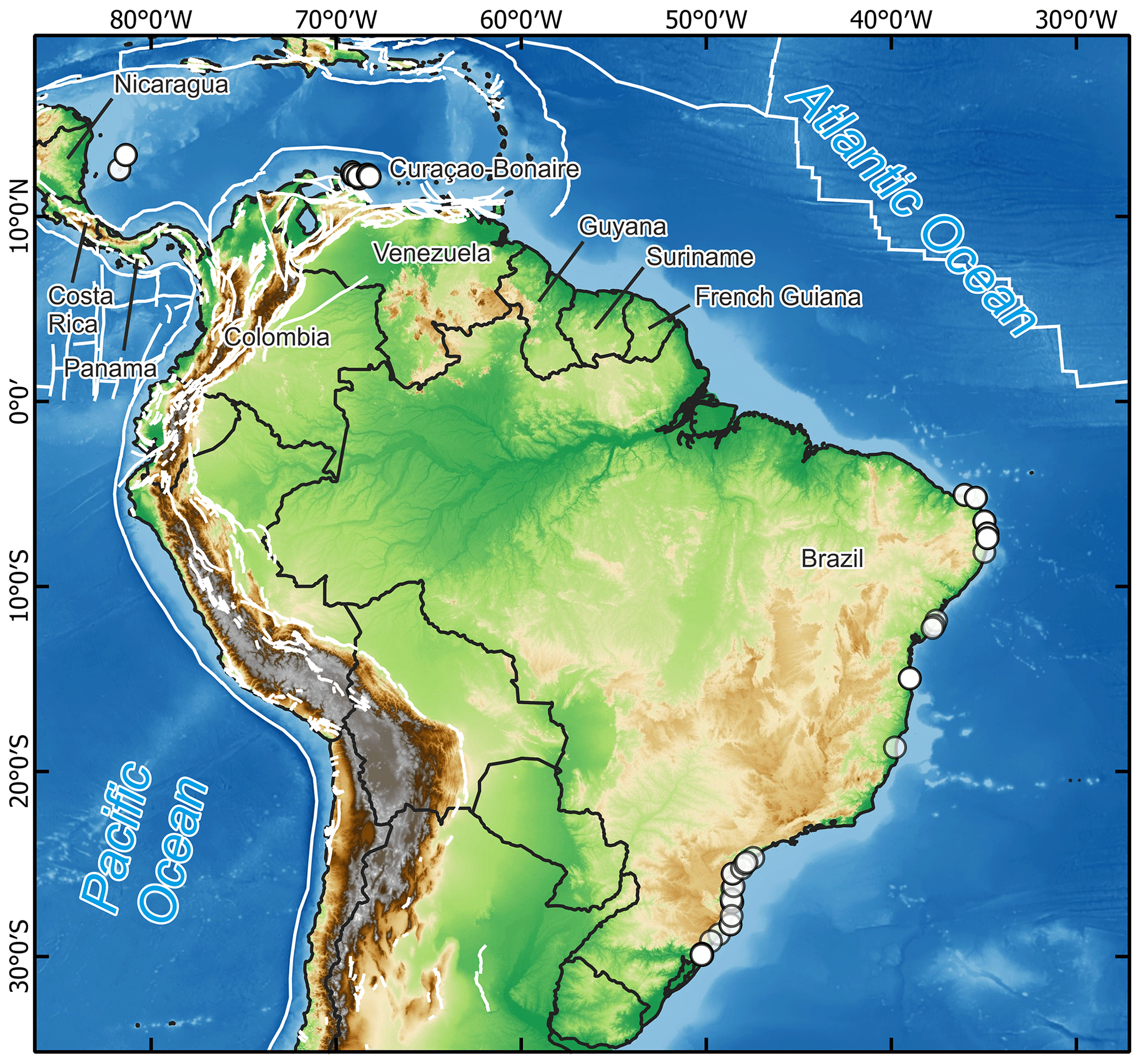
Figure 1General overview of the areas surveyed in this study. Dots show the location of sea-level data points inserted in WALIS. White lines indicate the location of active faults and tectonic plate boundaries from the Global Active Faults Database (Styron and Pagani, 2020). Basemap compiled by terrestris (https://www.terrestris.de, last access: 18 October 2021), with data from GEBCO (https://doi.org/10.5285/836f016a-33be-6ddc-e053-6c86abc0788e), SRTM 30 m by NASA EOSDIS Land Processes Distributed Active Archive Center (LP DAAC, https://lpdaac.usgs.gov/, last access: 18 October 2021), and Natural Earth (http://www.naturalearthdata.com, last access: 18 October 2021).
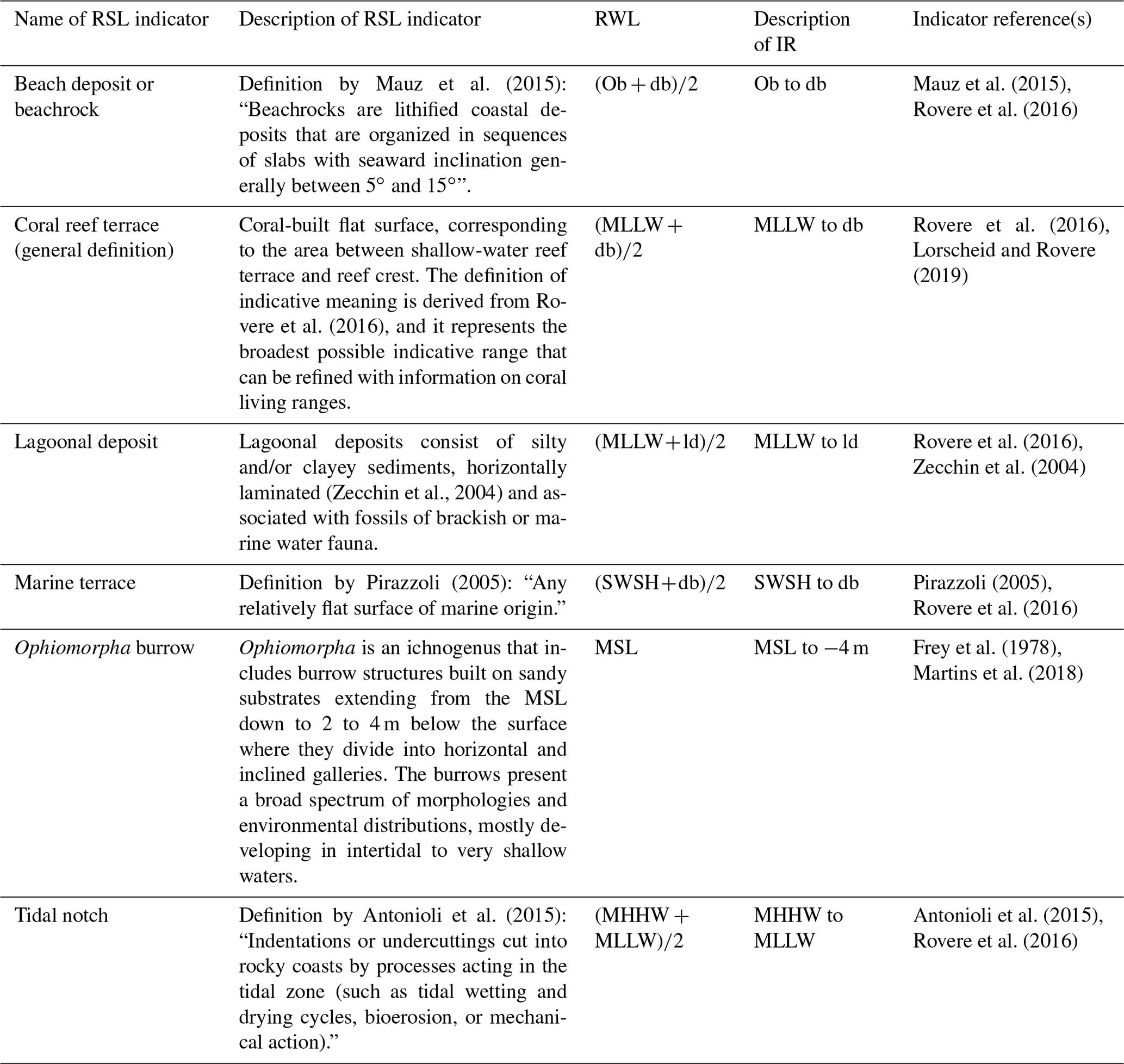
Within the region of interest (Fig. 1), we identified six main types of sea-level indicators (Table 1). In addition to these, cheniers of a possible last interglacial (LIG) age were reported in French Guiana and Suriname, and beach ridges were described in Venezuela. However, these latter instances were not included in the database due to an overall lack of sufficient information to produce standardized index points at these locations. To correlate each point with a paleo relative sea level, we applied the concept of indicative meaning that was introduced for Holocene sea-level studies (Shennan, 1982, 1986, 1989; Shennan et al., 1983) and recently also adopted for Pleistocene sea-level index points (Rovere et al., 2016). The indicative meaning “describes the central tendency (reference water level) and 2-sigma vertical range (indicative range) of the indicator's distribution relative to tidal levels” (Khan et al., 2019). In the database, we calculated the reference water level (RWL) and indicative range (IR) for each sea-level index point either using modern analogs (when reported by the original study) or applying ex situ quantifications derived from global wave and tide atlases, through the IMCalc tool (Lorscheid and Rovere, 2019).
In Brazil, marine terraces are the most widespread indicator type, although fossil beaches are also common. At several locations in Brazil, sandy sediments are characterized by the presence of the Ophiomorpha burrows ichnofacies (Barbosa et al., 1986; Bittencourt et al., 1979; Tomazelli and Dillenburg, 2007). The main observed ichnospecies is Ophiomorpha nodosa, which through comparison with burrows left by modern counterparts (Callianassa major; Frey et al., 1978) is considered an excellent sea-level indicator. Tomazelli and Dillenburg (2007) indicate that Ophiomorpha burrows allow the definition of the average low tide level during the deposition. However, we decided to adopt a more conservative indicative meaning (mean sea level (MSL) to −4 m) as Frey et al. (1978) report that, depending on the geographic region and environmental conditions, the burrows can also be found in shallow subtidal environments.
Several authors described coral reef terraces for the islands of Bonaire, Curaçao, and Aruba, located offshore Venezuela (Alexander, 1961; Schubert and Szabo, 1978; Schellmann et al., 2004). Several sea-level indicators, derived from coral reef terraces, are well preserved on the islands of Bonaire and Curaçao (Muhs et al., 2012; Felis et al., 2015; Obert et al., 2016; Lorscheid et al., 2017). Coral reef terraces are also reported on the Colombian islands of Providencia and San Andrés (Geister, 1972, 1986), located in the Caribbean Sea, offshore Nicaragua. At both islands, the whole reef complex is subdivided into different units according to their topography and ecology (Geister, 1992).
Table 1Sea-level indicators in the study area, with reference water level (RWL) and indicative range (IR) quantifications. db denotes breaking depth; ld denotes lagoonal depth; MHHW denotes mean higher high water; MLLW denotes mean lower low water; MSL denotes mean sea level; Ob denotes ordinary berm; SWSH denotes storm wave swash height.
In general, the majority of studies we reviewed do not report how elevations were measured (Fig. 2a). Whenever this was the case, we assumed an elevation measurement error equal to 20 % of the elevation reported (Rovere et al., 2016). This was also applied when elevations were derived from cross-section drawings in the original publications. Other elevation measurement methods include differential GPS, metered tape or rod, topographic mapping, and total station (Fig. 2a). Among these, the most accurate technique is differential GPS, used by Tomazelli and Dillenburg (2007) and Martins et al. (2018) in Brazil to report the elevations for the maximum height of Ophiomorpha burrows. Differential GPSs were also used by Muhs et al. (2012) and Lorscheid et al. (2017) in Curaçao and Bonaire, respectively. In this study, we also report new differential GPS elevation measurements taken by Alessio Rovere, Thomas Felis, and Thomas Lorscheid in 2016 on Bonaire at the same sites reported in Felis et al. (2015) and Obert et al. (2016). In northern Brazil, Suguio et al. (2011) used a total station to measure the elevation of different outcrops and referred the measurements to mean sea level using the tide-table predictions from two local stations. This technique also offers a good degree of absolute elevation accuracy (±0.1 m/±0.2 m), depending on the reference point and its distance from the base station. The rest of the elevation measurement methods reported have different degrees of precision depending on the reference object scale.
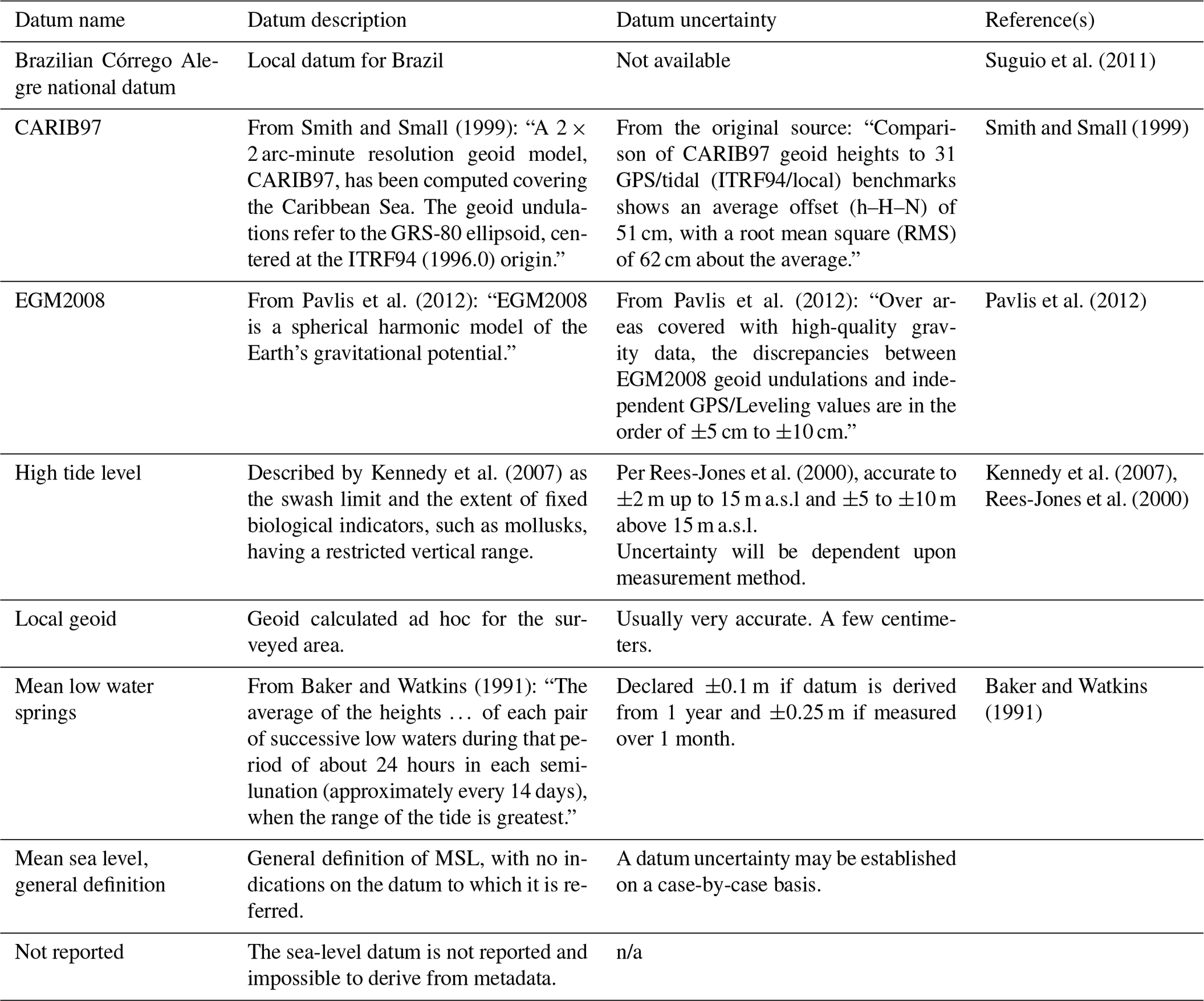
In Brazil, elevations were referred to different datums, such as mean low water springs (Tomazelli and Dillenburg, 2007), the local geoid (Martins et al., 2018), and local sea-level datums such as the Brazilian Córrego Alegre national datum (Suguio et al., 2011). Similarly, in Curaçao, a variety of datums are used: high tide level (Schellmann et al., 2004), CARIB97, and the locally resolved geoid for the Caribbean Sea (Muhs et al., 2012). The new GPS measurements from Bonaire reported for the first time in this paper are referred to the EGM2008 geoid (Fig. 2b, Table 2).
To obtain the geographic coordinates of the sites, in several cases it was necessary to use Google Earth or to geocode location names to gather latitude and longitude values. Relatively few studies provided site coordinates (Fig. 2c). Hence, we remark that, for some sites, the coordinates are to be interpreted as merely indicative of the general location of the site.
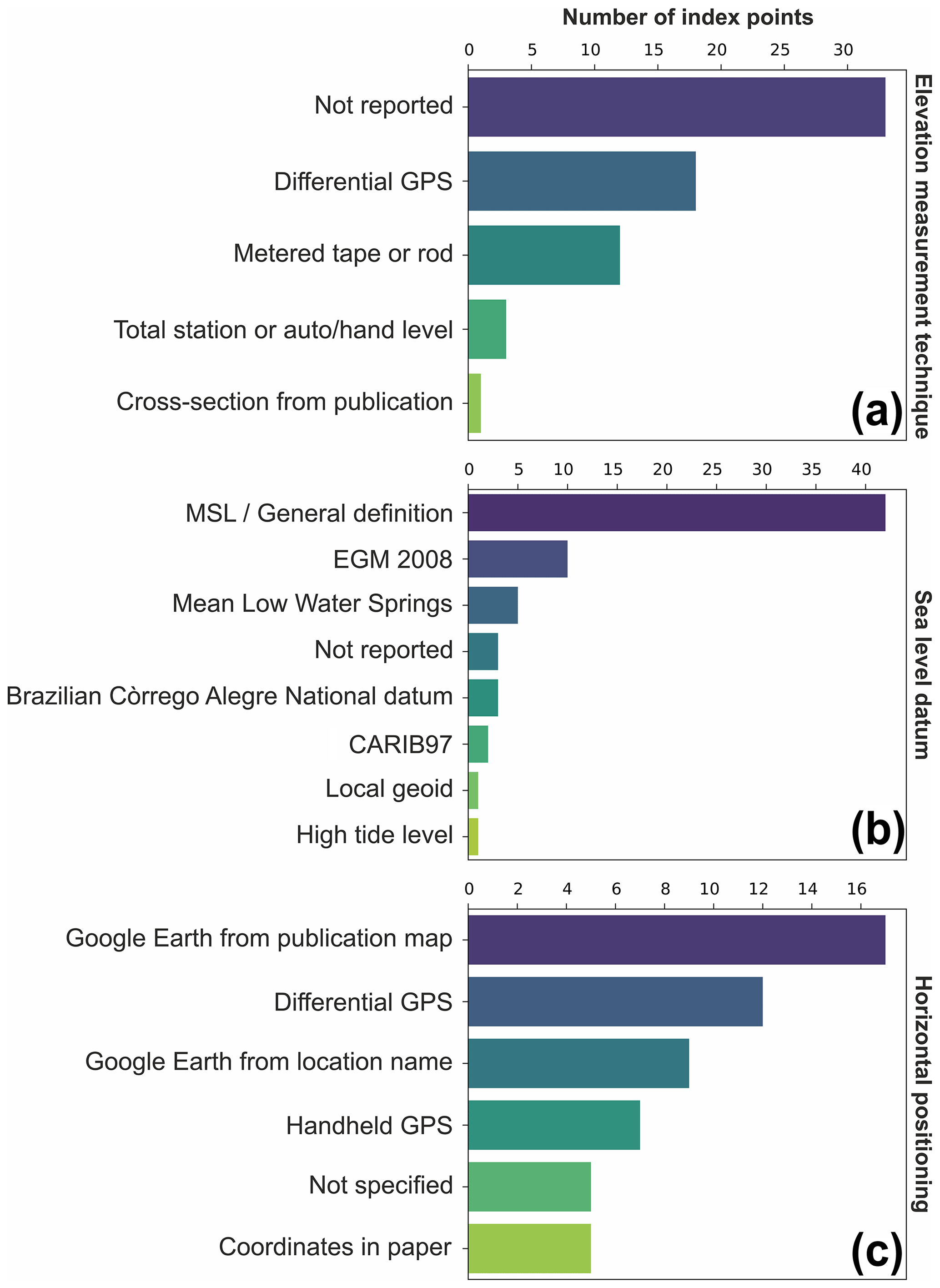
Figure 2Frequency of elevation measurement techniques (a), datums (b), and horizontal positioning techniques (c) used in the database.
The last interglacial deposits in the western Atlantic and southwestern Caribbean have been dated using a wide variety of techniques: U series, optically stimulated luminescence (OSL), thermoluminescence (TL), electron spin resonance (ESR), chronostratigraphy, and radiocarbon dates providing minimum ages. The abundance and preservation of corals on the islands Curaçao and Bonaire allow the application of U series to provide reliable age assignments (Muhs et al., 2012; Felis et al., 2015; Obert et al., 2016; Lorscheid et al., 2017). ESR has also been used by Schellmann et al. (2004) to date the coral reef terraces of Curaçao mainly to confirm the age of LIG deposits previously dated with U series by Schubert and Szabo (1978) and to present for the first time radiometric ages for older deposits.
Fossil corals have been preserved only at one site along the Brazilian coast. OSL and TL techniques have been used in different outcrops in northern and southern Brazil to assess the chronology of Pleistocene marine terraces (Poupeau et al., 1988; Barreto et al., 2002; Suguio et al., 2003, 2011; Buchmann and Tomazelli, 2003; Giannini et al., 2007).
Other age assignments rely on relative dating based on the cross-correlation of outcrops due to the stratigraphic similarities or radiocarbon dates (e.g., Bittencourt et al., 1979; Suguio et al., 1982; Angulo et al., 2002). When an outcrop had only minimum radiocarbon ages (radiocarbon ages above the detection limit), the deposit is considered older than Holocene. There are three chronostratigraphic constraints in Brazil (Barrier III in the Rio Grande do Sul state, the Cananéia Formation in the São Paulo state, and Sector I deposits in the Bahia state; see regional descriptions in Sect. 5 for details) and one in Bonaire (lower terrace). In Brazil, the chronostratigraphic constraints are common due to the preservation of Pleistocene deposits and their almost uninterrupted extension along the coastal plain. The Barrier III, Cananéia Formation, and Sector I deposits have been dated using OSL, TL, or U-series techniques and were attributed broader MIS 5 or more detailed MIS 5e ages (Tomazelli and Dillenburg, 2007; Suguio et al., 2003; Martin et al., 1982).
In the following sections, we describe the sea-level indicators in our database divided by country and, where applicable, by lower administrative boundaries (e.g., states, regions, provinces). An overview of the sites, the correlated paleo RSL, and the chronological attribution associated with them are reported in Table 3. We refer to the sea-level indicators included in the database with their WALIS RSL ID number, shortened here to RSL ID. This number is included in the first column of the “RSL proxies” spreadsheet within the database and is a unique ID attributed automatically to each data point entered into WALIS.
Table 3Proxies compiled in this study. Elevation and paleo RSL errors are reported as 1σ; age uncertainties (where an absolute age is indicated) are 2σ. Type of data points: SLI denotes sea-level indicator; TLI denotes terrestrial limiting; MLI denotes marine limiting. Dating techniques are abbreviated as follows: LUM is luminescence; STRAT is chronostratigraphic constraints; Other is other age attribution; U–Th is U series; ESR is electron spin resonance. * denotes ages recalculated by Chutcharavan and Dutton (2021). For the U-series ages on Bonaire, Brocas et al. (2016) report the following average ages: 1 BON-5-A is 121±1.1 ka. 2 BON-26-A is 124.9±1.9 ka. 3 BON-24-AII.2 is 125.5±2.4 ka. 4 BON-12-A is 123.9±1.3 ka.
5.1 Brazil
Studies describing the marine deposits in Brazil date back to the late 1800s (Hartt and Agassiz, 1870). In the early 1970s, the study of Quaternary coastal deposits began with Suguio and Petri (1973) describing the Iguape–Cananéia lagoonal region at the border between the regions of São Paulo and Paraná (Fig. 3). Later, the stratigraphic units of the state of Bahia were analyzed by Bittencourt et al. (1979) and further by Martin et al. (1982) and Bernat et al. (1983). These authors gathered new information on past sea-level changes and their meaning in the context of tectonic deformations. In the 1980s and 1990s, the exploration of Pleistocene deposits was extended to the states neighboring Bahia. In the south, Pleistocene outcrops were reported in Espírito Santo (Suguio et al., 1982), Rio de Janeiro (Martin et al., 1986, 1998), São Paulo (Suguio and Martin, 1995), and on the southern border of Brazil at Rio Grande do Sul (Villwock, 1984; Poupeau et al., 1988). To the north, studies focussed on the states of Sergipe (Bittencourt et al., 1983), Alagoas (Bittencourt et al., 1983; Barbosa et al., 1986), and Pernambuco (Martin et al., 1986; Dominguez et al., 1990). Most published papers presented data related to the Quaternary transgressive history of Brazil, describing the so-called “Penultimate Transgression” (called the “Cananéia Transgression” in the São Paulo state), attributed to MIS 5e (∼120 ka). The main highstand of this transgression was reported at an elevation of ca. 8 m above sea level (a.s.l.). In general, the study of the Last Interglacial in Brazil is hindered by the small number of reliable chronological constraints. Therefore, the most recent studies were directed to use radiometric dating techniques (such as OSL or TL) to establish radiometric ages for Pleistocene deposits (Barreto et al., 2002; Buchmann and Tomazelli, 2003; Suguio et al., 2003; Tomazelli and Dillenburg, 2007; Rossetti et al., 2011; Suguio et al., 2011; Bezerra et al., 2015).
The collective effort from these researchers over the years has made possible the knowledge of the Brazilian coastal plain geomorphological history and the description of the Pleistocene sea-level changes, preserved mostly in the form of beach and coastal deposits. According to the literature, the last interglacial sequences are present almost continuously on a north–south gradient from Rio Grande do Sul to Rio Grande do Norte, leaving only eroded remains in the most northern states (Fig. 3). Listed below are the published descriptions of the LIG deposits in this country, divided by administrative units (states).
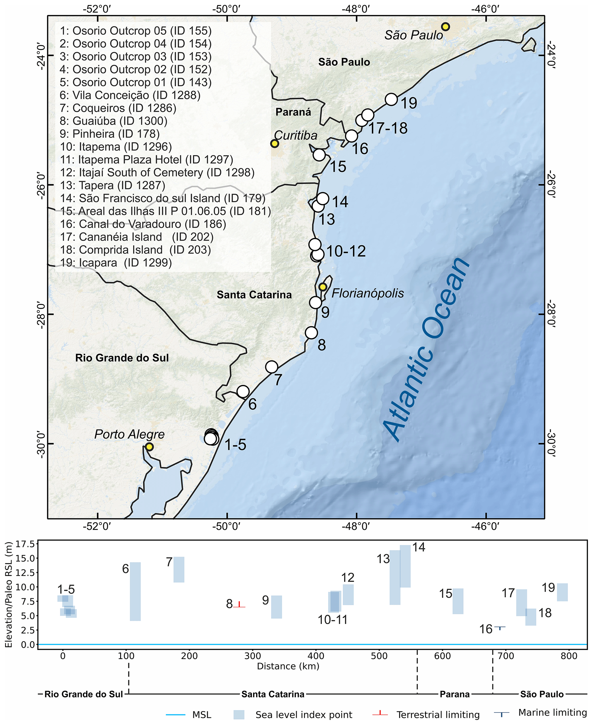
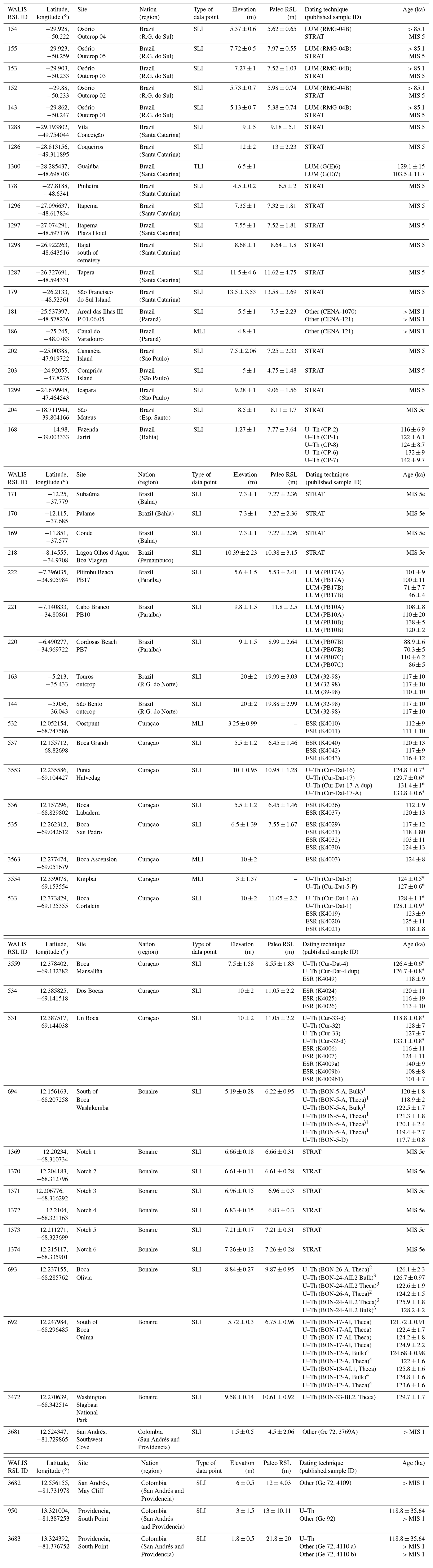
Figure 3Last interglacial sea-level data in the Brazilian states of Rio Grande do Sul, Santa Catarina, Paraná, and São Paulo. Upper panel: map of sites. Basemap: Esri, Garmin, GEBCO, NOAA NGDC (now NCEI), and other contributors. Lower panel: distance–elevation plot.
5.1.1 Rio Grande do Sul
Villwock (1984) and Tomazelli et al. (2006) described a system of Pleistocene lagoon barriers sub-parallel to the modern coast throughout the Rio Grande do Sul coastal area. Among these barriers (named I, II, and III), Barrier III is the best preserved and has an almost continuous extension between the cities of Tramandaí (to the north) and Chuí (to the south). This barrier was associated with the LIG transgression because it occurs at the back of the Holocene lagoon-barrier system (Tomazelli et al., 2006). Tomazelli and Dillenburg (2007) re-assessed the age and elevations of Barrier III deposits at Osório, describing five outcrops of foreshore sands with abundant Ophiomorpha ichnofossils (RSL IDs 143 and 152 to 155) (Fig. 3). The deposits are 4–5 m thick, and their reported elevations refer to the maximum elevation of Ophiomorpha burrows, ranging from 5.13 ± 0.7 to 7.72 ± 0.5 m above mean low water springs (elevations measured with differential GPS). The authors recognize that there are limited chronological data for these outcrops but highlight that a minimum age for the foreshore deposits is available for one of the sites, where coastal dunes covering the foreshore sands were dated with TL to 85 ka (Poupeau et al., 1988). Buchmann and Tomazelli (2003) used TL to date a similar foreshore deposit at Bujuru (Conceição Lighthouse) to 109 ± 7.5 ka. One photo in Dillenburg et al. (2009) (their Fig. 3.16) shows that this outcrop is possibly located a few meters above the modern sea level. In our literature survey, we were not able to find further details on the luminescence age reported by this study or on elevation measurements of this outcrop; therefore we do not include it in our database.
5.1.2 Santa Catarina
In the state of Santa Catarina, deposits correlated with Barrier III deposits of Rio Grande do Sul (lagoon and barrier facies) were reported in a series of 1 : 100 000 geomorphological maps (Horn Filho et al., 2014, and references therein). The deposits are mapped as widespread across the coastal plain. A geological field trip guide by Horn Filho et al. (2017) describes Upper Pleistocene lagoonal/beach deposits at three sites: Vila Conceição (RSL ID 1288), Coqueiros (RSL ID 1286), and Tapera (RSL ID 1287). These three outcrops are located at elevations of 9–12 m a.s.l., but their elevations are bounded by large uncertainties as it is unclear how they were measured (Fig. 3).
More accurate elevation measurements are available in recent work by Martins et al. (2018). These authors investigated Ophiomorpha burrows within Barrier III deposits at Pinheira (RSL ID 178). They used differential GPS to measure the top of Ophiomorpha at 4.5 m a.s.l. (Fig. 3).
Another site where beach/shallow marine (occasionally with Ophiomorpha burrows) deposits occur is São Francisco do Sul Island, located on the northern coast of the Santa Catarina state (Horn Filho and Simó, 2008). These deposits were reported at 10–17 m a.s.l. (RSL ID 179) but were assigned, in our database, as low quality due to uncertainties in their location and elevation. A detailed map (1 : 10 000) of the coastal deposits on São Francisco do Sul Island shows the distribution of Pleistocene lagoonal and beach deposits in this area (Horn Filho and Vieira, 2017). Accurate elevation measurements of these units will help to shed light on the correlation of these deposits with other sea-level indicators in the Santa Catarina state.
Summarizing the sandy marine terraces on the Santa Catarina state coast, Martin et al. (1988) report three additional sites attributed broadly to MIS 5: two at Itapema and one at Itajaí (RSL IDs 1296 to 1298). These are located at 6–8 m a.s.l. (Fig. 3).
Approximately 8 km south of Imbituba, Giannini et al. (2007) used OSL to date deposits associated with “alluvial-eolian deflation” and “eolian accumulation” facies. These deposits yielded ages of 129.1 ± 15 ka and 103.5 ± 11.7 ka, respectively. The deflation facies is located at a lower elevation (6.5 m a.s.l.) than the accumulation facies and was inserted into WALIS (RSL ID 1300) as a terrestrial-limiting point.
5.1.3 Paraná
In the state of Paraná, Branco et al. (2010) report a Pleistocene barrier at elevations between 5 and 10 m a.s.l. Among 19 stratigraphic sections, they report the presence of Ophiomorpha burrows at Section P 01.06.05 (RSL ID 181) at 5.5 m a.s.l. (Fig. 3).
Angulo et al. (2002) describe a marine terrace deposited on an estuarine paleo-channel in Canal do Varadouro (RSL ID 186) (Fig. 3). The sediments are approximately 1 m thick and have an undulated lamination, suggesting that they formed within an intertidal environment. The reported elevation is 4 m above the current high tide level (4.8 m a.s.l.). For both sites in the state of Paraná, only minimum ages are available.
5.1.4 São Paulo
In the southern part of the São Paulo state, the Pleistocene Cananéia Formation (a sandy coastal unit first described by Suguio and Petri, 1973) is reported in the Iguape–Cananéia lagoon region on Cananéia and Comprida islands (Fig. 3). The formation is capped by a member characterized by sands with Ophiomorpha burrows (Martin and Suguio, 1976). This formation was initially considered MIS 5 based on minimum radiocarbon ages (Martin and Suguio, 1976), an age later confirmed by OSL and TL ages of 94 ka (average age from Watanabe et al., 1997), and 81.55 ± 4.5 ka (average age from Suguio et al., 2003). We identified two (poorly constrained) sea-level index points on Cananéia and Comprida islands (RSL IDs 202, 203). Both data points are derived from Martin and Suguio (1976). From the description in the paper, we interpreted them as marine terraces. On Cananéia Island, the Cananéia Formation is located between 5–6 and 9–10 m a.s.l. On Comprida Island, the altitudes vary from 2.5 to 3 m a.s.l. in the south and from 5 to 6 m a.s.l. in the north. As this difference is related to differential erosion to which the area was subject during the Holocene transgressive phase, we used the highest occurrence of the terrace as the reported elevation.
A cross-section in Martin et al. (1988) reports another sea-level indicator associated with the Cananéia Formation close to Icapara (RSL ID 1299) at 8.5 m above high tide (Fig. 3).
5.1.5 Rio de Janeiro
Martin et al. (1998) describe Pleistocene beach barriers and sandy terraces in the Rio de Janeiro state. These are located at 6–8 m a.s.l. (Isla and Angulo, 2016) and have been assigned to the Last Interglacial based on infinite radiocarbon ages. As no details on sea-level indicators are available for these terraces, we did not insert them into WALIS.
5.1.6 Espírito Santo
Suguio et al. (1982) studied the area near the Doce River mouth in the state of Espírito Santo. The authors describe the Pleistocene marine terraces which created an almost-continuous strip of 4 km along the north section of the coastal plain. In the São Mateus area, these marine terraces reach a height of 9 to 10 m a.s.l. datum (RSL ID 204) (Fig. 4), while to the south (close to the river entrance) the elevation ranges from 6 to 10 m and the terrace loses its continuity as a result of the erosive effect of the Holocene transgression. The authors did not present specific ages for these deposits but assume a stratigraphic correlation with those of the neighboring state Bahia (see below), which indicates deposition during the LIG.
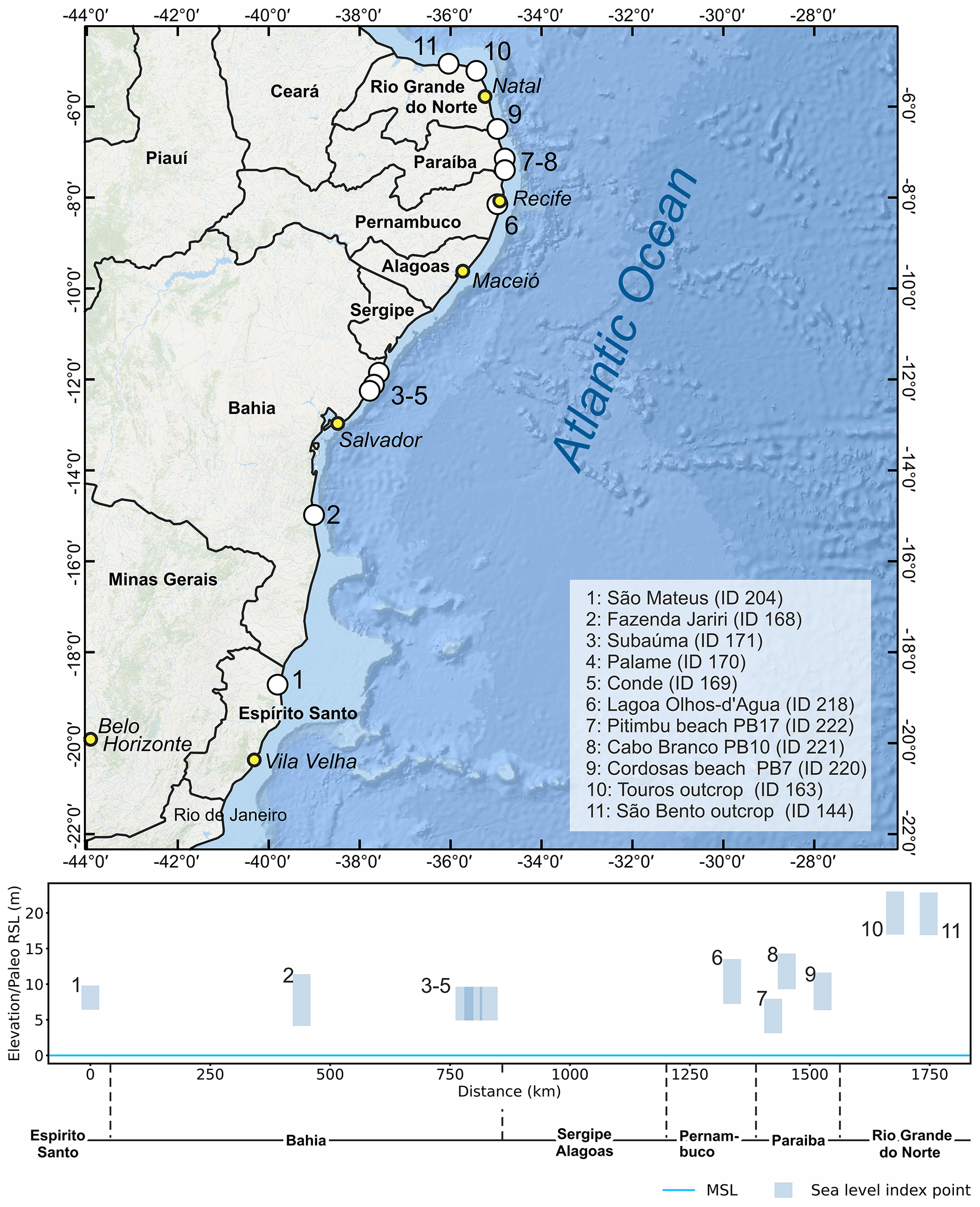
Figure 4Last interglacial sea-level data in the Brazilian states of Espírito Santo, Bahia, Pernambuco, Paraíba, and Rio Grande do Norte. Upper panel: map of sites. Basemap: Esri, Garmin, GEBCO, NOAA NGDC (now NCEI), and other contributors. Lower panel: distance–elevation plot.
5.1.7 Bahia
In the state of Bahia, Martin et al. (1982) identified a fossil coral reef at “Fazenda Jariri” at an elevation corresponding to the modern high tide mark (1.27 ± 1 m a.s.l.; RSL ID 168) (Fig. 4). They sampled 15 Siderastrea spp. corals, most likely, the species Siderastrea stellata, which is endemic to the coasts of Brazil and is reported as a primary bioconstructor in the shallow-water reefs in this area (Laborel, 1970). S. stellata is common in intertidal pools (de Oliveira Soares et al., 2017) with an average living range constrained between −3 and −10 m depth (Segal and Castro, 2000). We used these values as upper and lower limits, respectively, of the indicative range to calculate paleo RSL for this site at 7.8 ± 3.6 m. These corals yielded (alpha-counting) U-series ages between 116 ± 6.9 and 142 ± 9.7 ka.
Another three sites in the Bahia state are reported by Bittencourt et al. (1979): Conde, Palame, and Subaúma (RSL IDs 169, 170, 171) (Fig. 4). At these sites, the authors report that “the remnants of the penultimate transgression are indicated by a sand terrace, the top of which is situated 6 m above high tide level”. These deposits are associated with the so-called “Bahia Sector I” stratigraphy, which is attributed to MIS 5e thanks to the ages of Martin et al. (1982).
5.1.8 Sergipe and Alagoas
To complement the work carried out by Bittencourt et al. (1979), Bittencourt et al. (1983) analyzed the Pleistocene marine terraces deposited in the Sergipe state and south of the state of Alagoas. According to the authors, these sandy marine terraces present the same sedimentological and geomorphological characteristics as those observed in Bahia (Sect. 5.1.7). Therefore, the deposits can be inferred as spatially continuous from Bahia to Sergipe and Alagoas states (Barbosa et al., 1986). While the interglacial terraces are presented in maps within these publications, no precise location information is given; therefore these data were not inserted into WALIS.
5.1.9 Pernambuco
The Pleistocene marine terraces in the state of Pernambuco were described by Dominguez et al. (1990). Their elevations range from 7 to 11 m above the present high tide level; some outcrops show traces of ancient beach ridges in the region between Lagoa Olhos d'Agua and Boa Viagem (RSL ID 218) (Fig. 4). These terraces have similar sedimentological characteristics as those described in the states of Alagoas, Sergipe, and Bahia, suggesting a depositional continuity; however, in Pernambuco they are mostly present in small patches, arranged discontinuously along the coast. There are no absolute ages for the region, but these deposits are correlated with those in the state of Bahia (Dominguez et al., 1990).
There are indications of additional MIS 5 marine-associated deposits within the Pernambuco state. Suguio et al. (2005) and later Suguio et al. (2011) reported MIS 5 TL and OSL ages for sands that could be either marine or eolian in origin. Pending further clarifications on these deposits, we did not insert them into WALIS. On the island of Fernando de Noronha, eolianites within Unit I of the Pleistocene Caracas Formation (Almeida, 1955) returned minimum radiocarbon ages of 50 000 years BP (Angulo et al., 2013). The poor constraint on age and location has precluded entry of these deposits into WALIS.
5.1.10 Paraíba
Suguio et al. (2005, 2011) described Late Pleistocene marine terraces in the Paraíba state and dated them using TL and OSL techniques. Information to derive index points is given for only three of the nine dated outcrops. Two samples collected above 4.1 ± 1.5 m a.s.l. at Pitimbu Beach (Fig. 4) (RSL ID 220) yield TL ages of 101 ± 9 ka (PB17A) and 71 ± 7.7 ka (PB17B) and OSL ages of 100 ± 11 ka (PB17A) and 46 ± 4 ka (PB17B). These samples were collected from a massive sandstone unit, overlying a planar cross-stratification in sandstone. As no further details are given in the original papers, we interpret these sediments as part of a marine terrace and assign this data point a large indicative range. A unit composed of loose sands was dated at Cordosas Beach (RSL ID 222) and yielded TL ages of 88.96 ka (PB07B) and 110 ± 6.2 ka (PB07C) and OSL ages of 70.3 ± 5 ka (PB07B) and 86 ± 5 ka (PB07C). The best described among the outcrops of Suguio et al. (2011) is the one at Cabo Branco cliff (RSL ID 221) (Fig. 4). Here, at 9.8 m a.s.l., a sandstone facies is characterized by planar cross-stratification and Ophiomorpha burrows. This deposit yielded a TL age of 138 ± 5 ka and an OSL age of 120 ± 2 ka (sample PB10B). A sandstone unit immediately above the location where these samples were taken (sample PB10A) was dated 108 ± 8 ka (TL) and 110 ± 20 ka (OSL).
5.1.11 Rio Grande do Norte
Barreto et al. (2002) described two distinct marine terraces in the state of Rio Grande do Norte. The sediments of these terraces were grouped into two stratigraphic units, dated to 220–206 and 117–110 ka with luminescence techniques. The younger 117–110 ka marine terrace deposit is preserved for about 120 km along the E–W coast and was associated with the highstand of MIS 5e. Two outcrops of this terrace, between São Bento and Touros, were described (RSL IDs 144, 163). The elevations of the shallow-water facies reported by Barreto et al. (2002) range from 1–10 m a.s.l. and 2 km north of the town of Zumbi rise to a maximum of 20 m (Fig. 4). Therefore, the authors suggested a regional tectonic uplift by 10–12 m (considering the mean reported MIS 5e highstand of Brazil: 8 ± 2 m a.s.l.; Barreto et al., 2002).
5.1.12 Amapá
In the northernmost states of Brazil, information on Pleistocene marine deposits was generally lacking until the recent work of Bezerra et al. (2015) in the state of Amapá. These authors define the Pleistocene “Itaubal Formation” and subdivide it into two progradational units (upper and lower), separated by an unconformity. Using OSL ages, the Itaubal lower unit was constrained to MIS 5 (120 to 71 ka). Detailed facies analysis along several outcrops allowed Bezerra et al. (2015) to assert that the Itaubal lower unit is representative of “subtidal and tide-influenced meandering stream and floodplain deposits”. While this study presents accurate chronological data and detailed facies analysis of the lower unit, it is not possible to insert any index point into the database due to the lack of any absolute elevation measurements constrained to the modern sea level (only outcrop thickness is reported). However, we remark that this area looks promising for future research, especially because of the limited number of LIG deposits preserved in northern Brazil.
5.2 French Guiana, Suriname, and Guyana
French Guiana, Suriname, and Guyana share a very similar geological setting. Along the coasts of these three countries, different authors report the presence of littoral deposits that were emplaced by previous sea-level highstands (Brinkman and Pons, 1968; Iriondo, 2013). These deposits were studied by Choubert (1956) and Boyé and Cruys (1961), who described a unit made of sands and clays parallel to the shoreline that was initially attributed to the Riss-Würm (MIS 5) transgressive event. In French Guiana and Suriname, similar sedimentological facies are named the “Coswine Series” and “Coropina Series”, respectively. Brinkman and Pons (1968) propose that the Coswine and Coropina series are divided into two members, the Para Member (attributed to the Middle Pleistocene) and the Lelydorp Member (attributed to the Eemian interglacial, MIS 5e). These authors suggest that the Lelydorp Member outcrops between the towns of Cayenne and Organabo in French Guiana and the district of Coronie in Suriname.
The attribution of the Lelydrop member to MIS 5e was due to a radiocarbon date above the detection limit considered a minimum age by Brinkman and Pons (1968) (48 000 years BP, sample ID GRN 4718). Wong (1992) continued with the study of this region publishing “the Quaternary stratigraphy of Suriname”, in which he addressed the problem related to the chronological assignment of these eroded and weathered records. Wong et al. (2009) used paleomagnetic data to estimate ages along the Suriname coastal plain. The results suggest that the Lelydorp Member is of Early Pleistocene age, hence much older than hitherto assumed. Due to the lack of precise chronologic constraints, and with the work of Wong et al. (2009) essentially pre-dating the units previously assumed to be of last interglacial age, no data have been inserted in WALIS for French Guiana, Guyana, and Suriname.
5.3 Venezuela
The Pleistocene marine deposits of Venezuela are well known and have been extensively described by Bermudez and Farias (1975). As early as the late 1700s, Humboldt remarked upon formations now recognized as Pleistocene age within the state of Sucre (Bermudez and Farias, 1975). A couple of centuries later, Bermudez (1969) presented a detailed account of the Quaternary and recent stratigraphy of Venezuela. In this study, the author mentions Pleistocene marine units on Cabo Blanco (state of Miranda); on the south coast of the island of Tortuga; and on the islands Cubagua, Coche, and Margarita. In Cabo Blanco, Bermudez (1969) describes Pleistocene “raised beaches”, located at 62 m a.s.l. Danielo (1976) worked on the northern coasts of Venezuela and reported the presence of several Pleistocene beach deposits on the Araya and Paraguaná peninsulas, as well as in Puerto Cumareboy and Margarita regions. Among the different sea-level proxies on the northern coasts of Venezuela identified by the author, it appears that two would correlate with MIS 5, notably the so-called “Tyrrhénien I” (25–30 m) and the “Oujien” (6–8 m). Unfortunately, there is no dating associated with these deposits, therefore they could not be included in our database.
The Paraguaná Peninsula is one of the most studied sites in Venezuela that concerns Quaternary outcrops. Here, Rey (1996), described a 1.7 m thick conglomeratic sequence containing fragments of mollusks and foraminifera. The author interprets the depositional environment as that of a high-energy beach and reports that this unit cannot be older than the Pleistocene due to the presence of the marine foraminifera Globorotalia truncatulinoides. Audemard (1996a, b) reported several Pleistocene coastal outcrops along the Paraguaná Peninsula. On the southern coast of the peninsula, at Punta Cardón, Audemard (1996a, b) reports the presence of a fossil coral reef, with a height of 1.5 m, and species of the genera Porites preserved in living position within a “reddish sand matrix”. The author attributes this reef tentatively to MIS 5. To the west of the Paraguaná Peninsula, Audemard (1996a) reports a terrace with heights from 4 to 5 m a.s.l. This terrace presents sediments with different grain sizes and fragments of shells and corals. One radiocarbon analysis was performed on a coral fragment; its age was above the detection limit, and the author assigns an MIS 5 age. To the north of the Paraguaná Peninsula, the same author describes two eroded “isolated beach deposits” at Punta Macolla; despite not presenting an elevation for these, he correlates them with MIS 5.
After the work of Audemard (1996b), no further references could be found in this review. Up to now, none of the studies listed above presents radiometric dates, and the estimated ages were based on either geomorphological (Danielo, 1976; Audemard, 1996a, b; Rey, 1996) or biological (Bermudez, 1969; Bermudez and Farias, 1975) characteristics of the deposits described. Only the work of Audemard (1996a) refers to a single coral radiocarbon sample with an age beyond the dating limit. None of the studies listed was included in WALIS.
5.4 Aruba, Curaçao, and Bonaire (ABC) islands
Aruba, Curaçao, and Bonaire islands lie in front of Venezuela, forming the so-called “ABC islands” group. These three islands are included in this review due to their proximity to the Venezuelan coast and the quantity of last interglacial sea-level indicators that have been reported along their shores. The Pleistocene sea-level record at these islands is mostly preserved in the form of staircases of coral reef terraces (Alexander, 1961; Herweijer and Focke, 1978). These are usually wider along the windward sides of the islands than their leeward sides. The terraces display shore-parallel changes in elevation, which would suggest they have been affected by tectonic processes. This seems likely as they are located between the south Caribbean and South American plates (Hippolyte and Mann, 2011). The reef terraces are often interrupted by bocas, i.e., incisions in the continuity of the Pleistocene reefs that expose the stratigraphy of the terrace, which can be also observed along sea cliffs. These outcrops facilitated the study of paleo-ecological properties of Pleistocene reefs (Pandolfi and Jackson, 2001; Meyer et al., 2003) and their dating (Schellmann et al., 2004; Obert et al., 2016; Felis et al., 2015; Schubert and Szabo, 1978; Hamelin et al., 1991) and helped unravel their significance in the context of paleo relative sea-level changes (Lorscheid et al., 2017; Muhs et al., 2012; Kim and Lee, 1999). The evidence of MIS 5e reef terrace development on each island is briefly described in the following.
5.4.1 Aruba
In Aruba, the so-called “third terrace” (third terrace level counting from the modern sea level) was attributed to a “Sangamonian” (i.e., MIS 5e) age by Alexander (1961). The terrace is reported as well developed and is parallel to the shore along the northwestern coasts of the island. The terrace elevation is “25 feet” (7.6 m) a.s.l. While Pleistocene marine terraces appear prominent in the landscape of Aruba, we could not find any description or absolute ages to confirm the MIS 5e age designation; therefore, we did not insert any data point for Aruba into the database.
5.4.2 Curaçao
Several last interglacial MIS 5e index points were reported from the island of Curaçao (Fig. 5). The first U-series ages on corals from Curaçao were reported by Schubert and Szabo (1978) and later revisited by Muhs et al. (2012). We included in WALIS the sites reported by Schellmann et al. (2004), analyzed with ESR, and those reported by Muhs et al. (2012), measured with a differential GPS and analyzed with U series. In reporting U-series and ESR data for Curaçao, we included only those ages within MIS 5e. We did not insert into the database the U-series ages obtained by Hamelin et al. (1991), as they were rejected by the original authors due to (i) large difference in ages (multiple kiloyears) between different subsamples of the same coral or (ii) being outside the acceptable range for initial uranium isotopic composition.
Figure 5Last interglacial sea-level data in Curaçao. Upper panel: map of reported sites. The dashed line shows the location of the last interglacial terrace. The “single coral” data points represent coral elevations as reported in Chutcharavan and Dutton (2021). Background map compiled with data from GEBCO (https://doi.org/10.5285/836f016a-33be-6ddc-e053-6c86abc0788e) and SRTM 30 m by NASA EOSDIS Land Processes Distributed Active Archive Center (LP DAAC, https://lpdaac.usgs.gov/). Lower panel: distance–elevation plot.
In general, within the bocas dissecting the lower terrace of Curaçao, there are two distinct units where well-preserved corals (often in growth position) appear: the Cortalein (lower) and Hato (upper) units (Fig. 6). Both ESR and U-series ages confirm that the Cortalein unit was forming during MIS 7 (ca. 200 ka), while the Hato unit is MIS 5e in age (Muhs et al., 2012; Schellmann et al., 2004). We report in the database only the dated samples collected from the Hato unit. In the following paragraphs, we report sample IDs as indicated in Table 2 of Schellmann et al. (2004) and Table 1 of Muhs et al. (2012) (for U series).
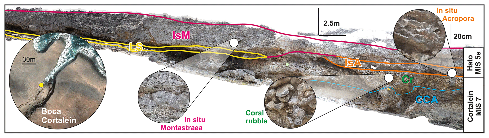
Figure 6Photomosaic with the interpretation of the paleo reef units of MIS 7 and MIS 5e age at Boca Cortalein, Curaçao (originally by Ann-Kathrin Petersen, edited by Alessio Rovere). IsM: in situ Montastraea sp.; LS: layered sediments (beachrock); IsA: in situ Acropora sp.; Cr: coral rubble; CCA: solitary corals and calcareous algae.
The elevations reported by Muhs et al. (2012) are referenced to the CARIB97 geoid (Smith and Small, 1999). We assigned an elevation uncertainty of 0.95 m, calculated from the root mean square of the sum of squares of the maximum error reported by Muhs et al. (2012) (0.8 m) and the CARIB97 datum uncertainty (0.51 m). Elevations for the sites mentioned in Schellmann et al. (2004) were taken directly from their Table 2, were referred to a general “mean sea level” datum, and were assigned an arbitrary uncertainty of 20 % of the measured elevation. A similar approach was used in reporting sites investigated by Schubert and Szabo (1978).
On the leeward (southeastern) side of the island, a reef sequence at Punta Halvedag (RSL ID 3553) was reported up to 10 m above the present sea level. For this sequence, we included in WALIS four ages reported by Muhs et al. (2012) on two corals (Cur-Dat-16 and Cur-Dat-17). Muhs et al. (2012) were concerned about the U values for seawater and considered the ages to be overestimated by ∼ 2.5–3.5 ka. Therefore, in WALIS we constrain the Punta Halvedag site as “younger than” these two corals, with the caveat that their age is most likely MIS 5e. North of Punta Halvedag, the same reef sequence is visible at Knipbai (RSL ID 3554). As little information on the stratigraphic context is given for this site, we inserted it into WALIS as a marine-limiting data point. From the Hato unit at this location, one Acropora palmata was dated (Cur-Dat-5; Muhs et al., 2012). Muhs et al. (2012) report that this coral “shows evidence of U gain, which would tend to bias the sample to a younger apparent age”. Therefore, in WALIS we constrain the Knipbai site as “older than” this coral.
On the windward (northwestern) side of the island, most of the locations reported in WALIS have been surveyed inside bocas, where corals have been dated with both ESR and U series. At Un Boca, three coral samples (99-6, 99-7, 99-9) yielded ESR ages between 101 ± 7 and 140 ± 9 ka (Schellmann et al., 2004). The top elevation of in situ corals at Un Boca is 10 m with significant uncertainties that stem from the unreported elevation measurement method. At Un Boca (RSL ID 531), Muhs et al. (2012) re-dated two corals, that had already been dated to MIS 5e by Schubert and Szabo (1978). The new analyses yielded ages of 118.1 ± 0.8 ka (Cur-33-d, Acropora palmata) and 132.3 ± 0.8 ka (Cur-33-d, Diploria sp.). The authors note that the sample Cur-32-d is probably biased old by 2.5–3.5 ka. One Acropora palmata coral (original ID 00-7) was analyzed by Schellmann et al. (2004) at a site located a few hundred meters south of Un Boca, called Dos Bocas (RSL ID 534). Three subsamples of this coral yielded ESR ages between 113 ± 10 and 120 ± 11 ka. The reef terrace at Dos Bocas was assigned the same elevation as Un Boca, based on the data reported by Schellmann et al. (2004). Slightly more than 1 km south of Dos Bocas, another site (Boca Mansaliña, RSL ID 3559) yielded one Acropora palmata coral (sample 00-13) analyzed using ESR to provide an age of 118 ± 9 ka (Schellmann et al., 2004) and one Siderastrea siderea coral (sample Cur-Dat-4), of which two subsamples gave U-series ages of 125.7 ± 0.7 and 126.0 ± 0.8 ka. The highest in situ coral at this location is reported at 7–8 m a.s.l., and it appears to have been sampled close to the top of the terrace (Fig. 8 panel 3 of Schellmann et al., 2004, and Fig. 8a of Muhs et al., 2012). Acropora palmata corals were also dated with ESR (00-5) and U series (Cur-Dat-1) at Boca Cortalein (RSL ID 533), yielding ages between 118–125 ka (with error bars between 8–11 ka) and a U-series average age of 127.3 ka (on two subsamples of the same coral). Also, at Boca Cortalein, we approximate the height of the reef terrace with the highest in situ coral, which is reported at 10 m a.s.l. (Schellmann et al., 2004). Approximately 15 to 18 km south of Boca Cortalein, three additional sites were reported by Schellmann et al. (2004) and Muhs et al. (2012). At Boca Ascension (RSL ID 3563), a Montastraea sp. coral yielded an ESR age of 124 ± 8 ka (99-3; Schellmann et al., 2004), but not enough stratigraphic information was given to establish a sea-level index point; therefore we insert this site into WALIS as marine limiting. At Boca San Pedro (RSL ID 535), four Acropora palmata corals (00-9) were collected at 6–7 m a.s.l. and were dated with ESR to 103–124 ka (Schellmann et al., 2004). In this case, a cross-section (Fig. 5-2 of Schellmann et al., 2004) shows that the highest of these corals was sampled close to the top of a reef terrace; therefore we consider this point a valid sea-level indicator.
Towards the southern part of the island, south of Curaçao International Airport, two nearby sites were dated with ESR by Schellmann et al. (2004): Boca Labadera (RSL ID 536) and Boca Grandi (RSL ID 537). These sites have ages ranging between 120 ± 13 and 112 ± 9 ka. At these two sites, all dated samples (n=5, WALIS ESR IDs 124 to 128) are close to the top of the terrace, were measured at 5–6 m a.s.l., and have been treated in WALIS as valid sea-level indicators. At the southern tip of Curaçao, one site was reported by Schellmann et al. (2004) as “Sheraton Hotel” and is here reported as Oostpunt (RSL ID 532). Here, two Acropora palmata corals (001-1) were sampled at 2.5–4 m. As no information is given on the stratigraphy of the reef terrace at this site, we insert this point into WALIS as a marine-limiting point.
5.4.3 Bonaire
The general coastal setting of Bonaire, similarly to that of Curaçao and Aruba, is characterized by broad (hundreds of meters wide) paleo reef terraces on the windward (northern and eastern) side of the island and narrow (tens of meters or less) paleo reef terraces on the leeward (southwestern) side (Fig. 7).
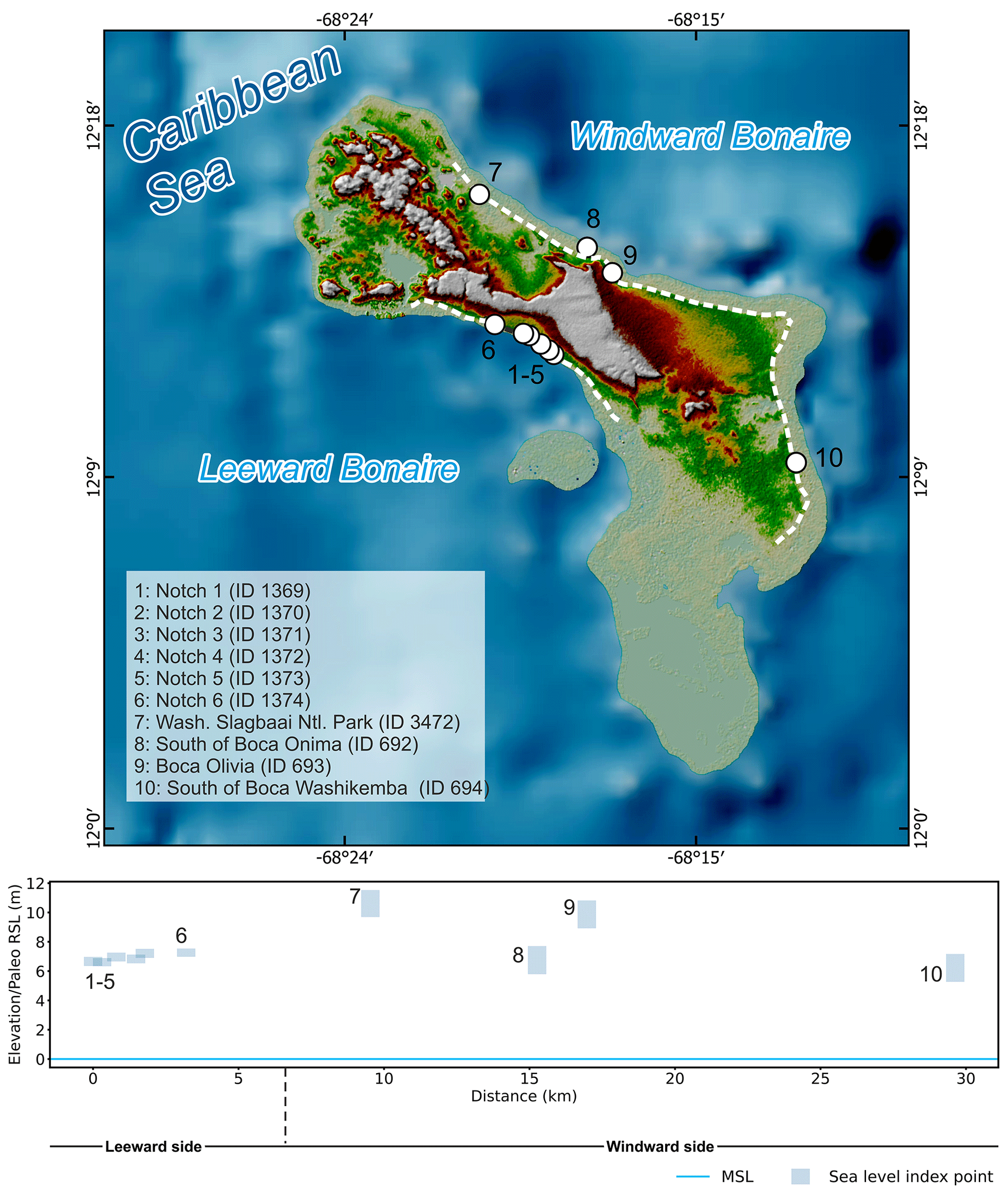
Figure 7Last interglacial sea-level data in Bonaire. Upper panel: map of sites. The dashed line shows the location of the last interglacial terrace. Basemap compiled with data from GEBCO (https://doi.org/10.5285/836f016a-33be-6ddc-e053-6c86abc0788e) and SRTM 30 m by NASA EOSDIS Land Processes Distributed Active Archive Center (LP DAAC, https://lpdaac.usgs.gov/). Lower panel: distance–elevation plot.
On the leeward side, Lorscheid et al. (2017) measured six tidal notches carved into limestones older than MIS 5e (Fig. 8a). The elevations of the notches were measured with a combination of differential GPS and laser rangefinders and are reported at between 6.61 and 7.26 m a.s.l. (RSL IDs 1369 to 1374). Samples of a fossil coral from the terrace immediately below the notches yielded initial activity ratios higher than expected from the modern seawater value and were therefore considered unreliable by Lorscheid et al. (2017). Nevertheless, the notches are considered coeval with the terrace immediately below (Fig. 8b), which is correlated with the better-dated terrace level on the windward side of the island, described below.

Figure 8(a) Tidal notch on the leeward side of Bonaire; (b) last interglacial reef 1–2 m below the location of the photo shown in (a); (c) exposed reef section on the windward side of Bonaire; (d) large massive coral eroded on top of the MIS 5e terrace on the windward side of Bonaire; (e) panorama view of the MIS 5e terrace on the windward side of Bonaire. Photos by Thomas Lorscheid (a), Alessio Rovere (b, c, e), and Thomas Felis (d).
Felis et al. (2015) and Obert et al. (2016) report several U-series ages from different skeletal parts (theca walls or bulk material) of nine corals located on top of the lower reef terrace characterizing the windward (northern and eastern) side of Bonaire (Fig. 8c, d, e). As there are multiple subsamples for some individual corals, Brocas et al. (2016) calculate the weighted mean and weighted standard error of five of these nine corals giving a range from 120.5 ± 1.1 to 125.85 ± 2.46 ka. Of the 42 ages reported by Obert et al. (2016) and 1 age reported by Felis et al. (2015), we inserted into WALIS only those accepted within the original publication (based on progressively less strict criteria), restricting the number of available ages to 25 (8 corals). The elevation of these samples was initially measured using an altimeter “calibrated” to the sea level at the time of measurement. The sampling sites were then revisited by Thomas Lorscheid, Alessio Rovere, and Thomas Felis in 2016, and each sampled coral on top of the reef terrace was re-measured with differential GPS and referred to the EGM2008 geoid. We report these new measurements in this paper for the first time. To provide additional constraint to each sample, an elevation was also recorded at the nearest accessible instance of the coral reef inner margin, which we consider here to approximate the paleo sea level with an indicative range included between the mean lower low water and the breaking depth, which we derived from IMCalc (Lorscheid and Rovere, 2019).
South of Boca Washikemba, Obert et al. (2016) and Felis et al. (2015) dated two corals: BON-5-A (120.5 ± 1.1 ka average age according to Brocas et al., 2016) and BON-5-D (117.7 ± 0.8 ka). The inner margin of the reef terrace 3 km north was measured at 5.19 ± 0.28 m, where in situ massive corals can be recognized (RSL ID 694). While this is the only site dated on the eastern coast of Bonaire, the wide coral reef terrace is almost continuous until a second site is reached on the northeastern coastline (identified within WALIS as Boca Olivia, RSL ID 693), where Obert et al. (2016) dated two other corals BON-26-A and BON-24-AII.2, giving average ages of 124.9 ± 19 and 125.5 ± 2.4 ka, respectively (Brocas et al., 2016). The inner margin of the coral reef terrace was measured 500 m inland of these two corals, at an elevation of 8.84 ± 0.27 m. At 3 km north of this point, south of Boca Onima (RSL ID 692), three corals (BON-17-AI, BON-12-A, and BON-13-AI.1) yielded an average age of 124.3 ± 1.5 ka (Obert et al., 2016; Brocas et al., 2016). The inner margin correlated to these corals was measured very close to the sample locations, at an elevation of 5.72 ± 0.3 m. At 4 km north of Boca Onima close to the Washington Slagbaai National Park border (RSL ID 3472), Obert et al. (2016) dated one coral (BON-33-BI.2) to 129.7 ± 1.7 ka. The inner margin of the terrace closest to this coral was measured at 9.58 ± 0.14 m. The measured elevations show a trend of becoming higher towards the north. That the coral ages reveal a broad trend from younger at lower elevations in the south to older at higher elevations in the north, with intermediate ages at intermediate elevations in between, has been noted by Obert et al. (2016) and attributed to the slight tilting of the island with relative uplift in the north and submergence in the south (Hippolyte and Mann, 2011). Consequently, this trend is unlikely to reflect past sea-level variations (Obert et al., 2016).
5.5 Colombia to Honduras
The coastal deposits of Colombia associated with the LIG have been mainly studied and described on offshore islands (Porta and Solé de Porta, 1960; Bürgl, 1961; Geister, 1972, 1986, 1992). Porta et al. (2008) mentioned the existence of marine terraces and coral platforms of different elevations along the mainland Colombian coast, mainly between Cartagena and Barranquilla; however, no further details are given on their ages or elevations or specific locations.
Porta and Solé de Porta (1960) describe the Quaternary coastal deposits on Tierra Bomba Island. While the main focus of their paper is to describe the marine faunas of the islands, the authors mention Pleistocene marine terraces with heights of more than 20 m; however, none of these deposits are directly correlated with the Last Interglacial. One year later, Bürgl (1961) mentions three geological and geomorphological units on the island of San Andrés: (i) a marine platform of recent age, (ii) a terrestrial platform of Pleistocene age, and (iii) inland limestones of Miocene age. Geister (1972) hypothesizes that the deposits on the “terrestrial” platform were formed during a marine transgression and correlates them with coral terraces observed on Providencia (Fig. 9) according to its geomorphology. Geister (1986) suggests the Providencia terraces are of Sangamon Interglacial age (MIS 5) based on a minimum radiocarbon age. The same author (Geister, 1992) later described this and the rest of the coral deposits of Providencia. He highlights that this fossil reef terrace is the only emerged relict of the Pleistocene complex which now underlies the Holocene deposits.
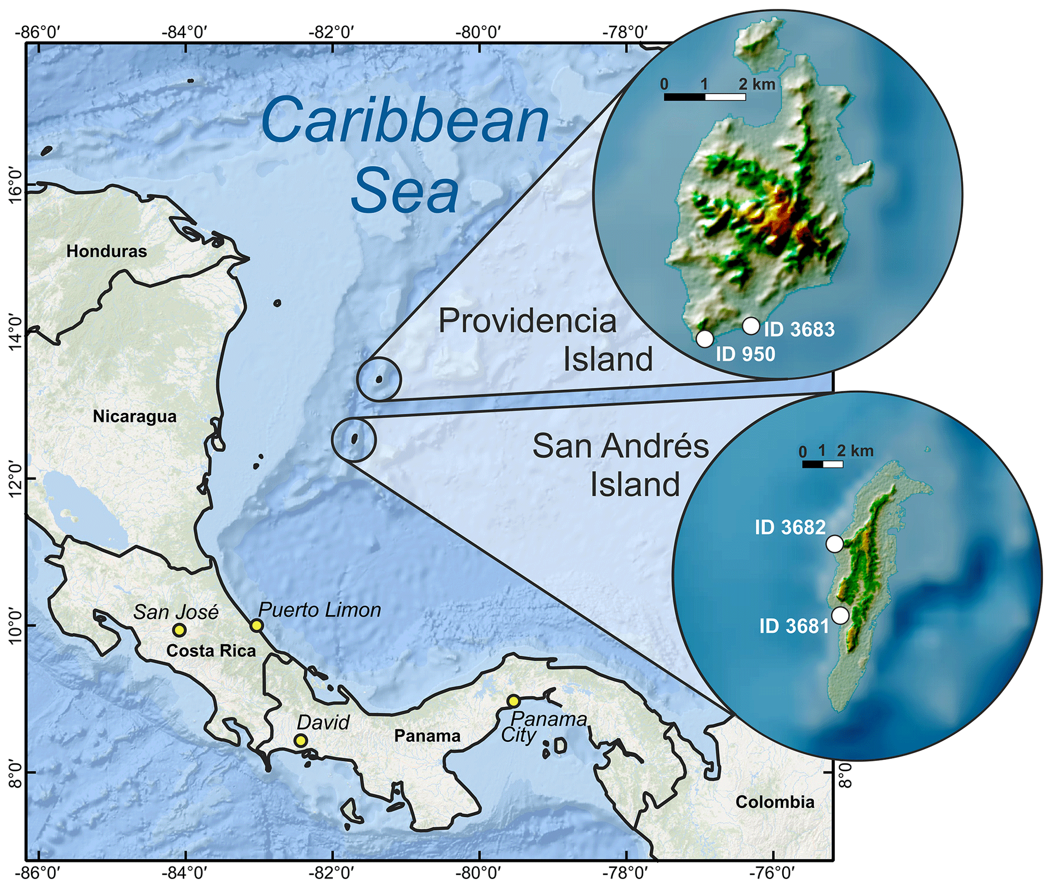
Figure 9Location of Providencia and San Andrés islands within the Caribbean Sea. The insets show last interglacial sea-level data on the two islands. Basemap: Esri, Garmin, GEBCO, NOAA NGDC (now NCEI), SRTM 30 m by NASA EOSDIS Land Processes Distributed Active Archive Center (LP DAAC, https://lpdaac.usgs.gov/).
Literature describing MIS 5 relative sea-level indicators in Panama, Costa Rica, Nicaragua, and Honduras is scarce. Only one study in Costa Rica mentions the presence of a paleo-coral reef for which an Eemian age (MIS 5e) is postulated, in Puerto Viejo (Bergoeing, 2006). We surmise that it is possible that MIS 5 outcrops have not yet been described or do not exist in Panama, Nicaragua, and Honduras. For Panama and Costa Rica, several studies focus on the Pacific zone (Bee, 1999; Davidson, 2010; Bauch et al., 2011), which is out of the area of interest for this paper. No studies have been found in Nicaragua and Honduras, but we do not discard the possible existence of descriptions of MIS 5 outcrops in journals that we could not access online.
5.5.1 San Andrés
From the work of Geister (1972), it is possible to derive two sea-level indicators (generally defined as reef terraces) on the island of San Andrés. One is located on the south of the island at a point called Southwest Cove (RSL ID 3681) and the second to the north, at May Cliff (RSL ID 3682) (Fig. 9). The elevation of the Southwest Cove site was 1.5 m a.s.l., and the coral sampled belonged to the species Acropora palmata, which has an average living range between −1 and −5 m depth (Lighty et al., 1982). We use these values as the upper and lower limit, respectively, of the indicative range to calculate the paleo RSL for this site at 4.5 ± 2.06 m (RSL ID 3681). This sample was radiocarbon dated, giving an age of 26 020 ± 675 years BP, which according to the authors should be considered a minimum age. The May Cliff sample comes from a Dendrogyra cylindrus coral (from −2 to −10 m living range in San Andrés, as reported by Cavada-Blanco et al., 2016) found at 6 m a.s.l. with a minimum radiocarbon age of 33 000 ± 770 years BP. Considering the average living range of D. cylindrus (Cavada-Blanco et al., 2016) on this island, the paleo RSL calculated is 12 ± 4.03 m (RSL ID 3682).
5.5.2 Providencia
To the south of the island of Providencia, Geister (1972) reports the elevation and two radiocarbon dates (33 310 ± 2300 years BP and 29 270 ± 930 years BP) of a specimen of the coral Siderastrea radians. The reported elevation of the sample is 1.8 m a.s.l., and both radiocarbon dates were considered minimum ages. Twenty years later, the same author describes a coral reef terrace at about +3 m at a site called South Point (RSL ID 950) (Fig. 9). One U-series age confirms the association of these deposits with MIS 5e, albeit with a large error (118 ± 11.0 ka; U-Series ID 2026) (Geister, 1992).
The western Atlantic and southwestern Caribbean database is available at https://doi.org/10.5281/zenodo.5516444 (Version 1.02; Rubio-Sandoval et al., 2021). The description of the database fields can be found at https://zenodo.org/record/3961544 (Rovere et al., 2020).
7.1 Data quality
Each RSL data point in our compilation has been assigned two quality scores, one for age and one for RSL information. The quality ranking goes from 0 (rejected) to 5 (excellent) and follows the guidelines given in Rovere et al. (2020). Thanks to the standardized WALIS interface, similar scores are also available for RSL data points located to the south and to the north of our region, which were compiled into WALIS by Gowan et al. (2021) and Simms (2021). In Fig. 10, we compare the quality scores assigned in our review to those assigned by these studies. This comparison shows that the quality of both age and RSL information for our study area is, in general, higher than those in the nearby sites. However, the high scores on both properties are driven by the sites in the ABC islands, and no site in Brazil goes above the “average” age scores. Concerning the RSL information, in Brazil only the sites described by Tomazelli and Dillenburg (2007) and Martins et al. (2018) have been scored as “good” to “excellent”. This means that, potentially, these sites have final uncertainties in the paleo RSL below 2 m, but their attribution to MIS 5e should be supported by more reliable dating.
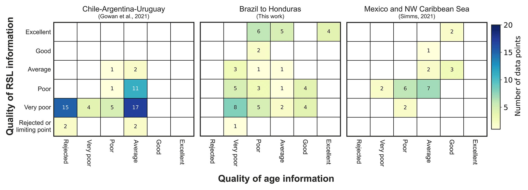
Figure 10Quality of RSL and age information as estimated by (from left to right) Gowan et al. (2021) for Chile–Argentina–Uruguay, Brazil–Honduras (this study), and Mexico and the NW Caribbean Sea (Simms, 2021). All studies used the same rationale to give a score to age and RSL information (see Rovere et al., 2020).
7.2 Departures from the eustatic signal
While in the WALIS interface there is the option to compile data and metadata on tectonic rates that affect each reported RSL data point, we chose to leave these fields blank. The reason behind this choice is that late Quaternary tectonic rates along the coasts covered by our review are often back-calculated from the elevation of the last interglacial shoreline and assumptions about the MIS 5e eustatic sea level, and therefore inserting such rates into the database would be affected by circularity. However, we remark that the area is characterized by different tectonic settings. The southern portion of Brazil (Fig. 3) is located roughly in the center of the South American Plate and hence sits on a passive margin. Towards the north (Fig. 4), several authors noted an increase in seismicity and highlighted the presence of faults offsetting Neogene deposits (Bezerra et al., 2006).
As remarked in the regional descriptions above, in this area last interglacial deposits appear higher than 20 m and are hence considered uplifted (Barreto et al., 2002). The ABC islands are located on the Caribbean Plate, hence the elevation of MIS 5e sites on these islands is affected by tectonic displacement. Based on several levels of Quaternary reef terraces, Muhs et al. (2012) calculated that sites on the island of Curaçao are characterized by uplift rates on the order of 0.026–0.054 m/ka. Similarly, the island of Bonaire has also been affected by tectonic uplift, which appears to have caused a tilting of the island. Lorscheid et al. (2017) report that this tilting is 192 mm/km to the southeast, with the direction of the tilting comparing well with the one reported by Hippolyte and Mann (2011).
Besides tectonics, other regional processes might influence the elevation of RSL indicators in the area of interest. Earth dynamic topography has been shown to cause significant departures from eustasy in last interglacial sea-level records also along passive margins. Along the coasts of Brazil, Earth dynamic topography might contribute to several meters of uplift (Austermann et al., 2017, their Fig. 3A, C). However, these predictions are still bounded by significant uncertainties (Austermann et al., 2017, their Fig. 3B) and cannot be employed to “correct” the RSL records shown here.
Another significant factor that may have caused the displacement of last interglacial RSL data points is sediment isostasy (Pico, 2020), which is defined as the isostatic response to sediments deposited by large rivers on the shelf. In particular, this process may affect areas close to the Amazon river (Pico, 2020, their Fig. 3) causing net land subsidence on the order of tens of meters. This could explain why we did not find studies describing last interglacial RSL data points in this area, hinting that they might be located well below the modern sea level.
A further process that has surely affected the current elevations of last interglacial RSL sea-level proxies along the coasts of Brazil to Honduras is glacio- and hydro-isostatic adjustment (GIA), which is caused by the isostatic response of the Earth to mass fluctuations of continental ice sheets. GIA consists of both solid Earth and mean sea surface (i.e., geoid) vertical variations that show up as relative sea-level (RSL) variations. The deviation of the local GIA-modulated RSL changes from the global mean, i.e., “eustatic”, sea-level change, depends primarily on the distance from the ice sheets. During glacial periods such as MIS 6, the crust subsides underneath a growing ice sheet in response to the ice load. The upper mantle material is therefore pushed outwards to accommodate the bending lithosphere. At the same time, the increased mutual gravitational pull between the ice mass and the ocean water causes the latter to rise in the proximity of the ice margins. As a result, ice-proximal locations experience RSL rise, which is significantly larger than the eustatic fall. Further away from the ice margins, the crust undergoes uplift in response to the upper mantle flow that is directed radially outwards and upwards. This is the so-called uplifting peripheral forebulge area, where the local glacial RSL drop is significantly larger (and faster in time) with respect to the global eustatic drop. Moving away from the forebulge, the local RSL drop tends to approximate the global eustatic signal, with deviations that depend on the water-loading redistributions in response to solid Earth and gravitational as well as rotational perturbations.
During deglacial and interglacial periods such as MIS 5, the GIA process operates in the same way, but the overall trend switches. Accordingly, RSL drop is expected over the previously ice-covered region, while the collapse of the uplifted peripheral forebulge results in RSL rise larger than the eustatic one. Interestingly, during the termination of the deglacial phases, the far-field areas that are either along the continental margins or in the equatorial band comprised between the tropics do experience a noticeable RSL fluctuation that consists of an early highstand (above the eustatic value), which is then followed by a drop. Two processes are at work here: (i) the so-called continental levering, which consists of an upward tilt of the continental margins in response to the subsidence of the ocean basins which are loaded with meltwater, and (ii) the ocean syphoning, where water migrates towards the collapsing peripheral forebulges in response to ocean mass conservation.
7.3 Last interglacial sea-level fluctuations
The current research status of the Last Interglacial in the western Atlantic and southwestern Caribbean does not allow for the discernment of sea-level oscillations within MIS 5e, since most studies in the region lack the refined chronology necessary to identify such detailed sea-level patterns. However, we remark that this area might help to solve several questions related to the presence and magnitude of sea-level oscillations during MIS 5e if high-quality data were to become available.
To illustrate this point, we model the GIA-modulated RSL changes by solving the gravitationally self-consistent sea-level equation (SLE; Spada and Stocchi, 2007). We use a solid Earth model that is spherically symmetric, self-gravitating, and rotating and is divided into shells that are characterized by a linear Maxwell viscoelastic rheology. We divide the mantle into three layers and impose a vertical stratification of viscosity following the VM2 mantle viscosity profile of Peltier (2004). We force our model with the ANICE–SELEN ice sheet chronology, which consists of four ice sheets (North America, Eurasia, Greenland, and Antarctica) and covers the last 410 kyr of climate fluctuations (i.e., four glacial-to-interglacial cycles; de Boer et al., 2014). For the MIS 5e interglacial, we impose a global mean-sea-level scenario where Greenland and Antarctic ice sheets release 2.5 and 1.0 m ESL equivalent, respectively, at 127 ka. The Greenland Ice Sheet remains stationary until 117 ka, while the Antarctic Ice Sheet releases another 4.5 m after 120 ka. This scenario is in line with the “two-stepped” last interglacial sea level proposed by Hearty et al. (2007) and O'Leary et al. (2013), which is still debated as little evidence supports the notion of a rapid collapse of the Antarctic Ice Sheet (AIS; Barlow et al., 2018; Polyak et al., 2018).
The GIA model shows a strong latitudinal dependence of the RSL change along the transect composed by our compilation and those of Gowan et al. (2021) to the south and that of Simms (2021) to the north (Fig. 11b). Such a regionally varying RSL pattern depends on the interplay between the collapsing forebulge in the north and the continental levering and ocean syphoning in the south.
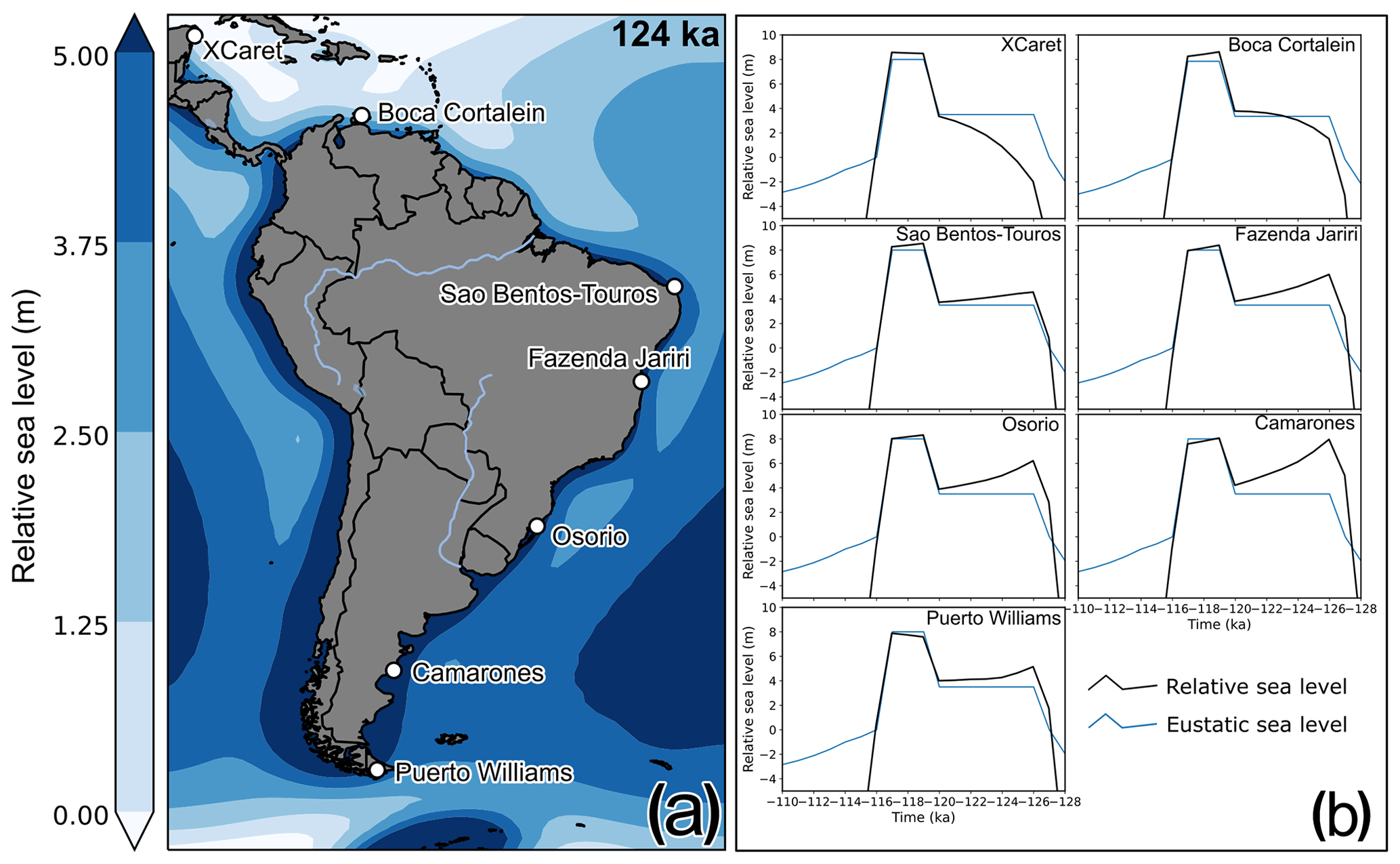
Figure 11(a) Relative sea level as predicted by the ANICE–SELEN model at 124 ka along a transect including selected sites in our review and those of Gowan et al. (2021) and Simms (2021); (b) time vs. RSL at each location shown in (a).
In particular, at the northernmost site of Xcaret, the predicted RSL elevation at 127 ka is still ∼ 6 m lower than the eustatic value (i.e., +3.5 m a.s.l.). This stems from the local contribution of the collapsing forebulge that was uplifted in response to the North American ice sheet glaciation at MIS 6. The viscous response of the upper mantle results in a delay of the local RSL change, which reaches, through a monotonic rise, the actual eustatic value only at 120 ka, i.e., immediately before the final jump that is caused by the AIS melting. A similar trend, albeit smaller in amplitude, is predicted at Boca Cortalein, thus implying that the forebulge-related processes cease to exist between Venezuela and northern Brazil, where a true eustatic “sea-level jump” is expected. The predicted RSL curve at São Bento–Touros is close to the eustatic, although the combination of levering and syphoning is visible in the form of a ∼ 1.0 m highstand at 127 ka, which is then followed by an RSL drop towards the eustatic value at 120 ka. The GIA-driven highstand at 127 ka increases towards the south and reaches its maximum at Camarones, i.e., at a significant distance from the North American ice sheet and Antarctica. Interestingly, the predicted highstand at 127 ka is of the same magnitude as the final peak between 119 and 117 ka. Under such a scenario, there should be evidence, along all the coasts of Argentina and central Brazil, of a high-to-low sea-level swing, caused by the interplay between GIA and eustatic changes. At Puerto Williams, instead, the proximity to the AIS results in a much lower highstand at 127 ka, most likely as a function of the reduced gravitational pull after MIS 6 and MIS 5e melting.
The effects of solid Earth and gravitational perturbations are also visible in the predicted elevations of the final jump that is caused by the AIS fast melting. The southernmost sites, being closer to the AIS, are affected by the geoid drop that is caused by the reduced gravitational pull. As a result, the predicted highstand is slightly lower than the eustatic one. On the other hand, the northernmost sites experience a higher-than-eustatic peak, again as expected by the self-gravitation process.
7.4 Other interglacials and Holocene sea-level indicators
Among the studies reviewed, there are some reported ages/inferences related to other Quaternary sea-level highstands. In Brazil, Barreto et al. (2002) and Suguio et al. (2011) describe shorelines with elevations ranging from −2 to 10 m a.s.l. that were associated with MIS 7 (substage 7c). In Curaçao, Schellmann et al. (2004) and Muhs et al. (2012) associate the lower terrace with MIS 7, estimating a paleo sea level between −3.3 and +2.3 m, and the middle terrace with MIS 11, estimating a paleo sea level ranging between approximately +8.3 and +10 m.
For the Holocene, the work of Khan et al. (2017) presents standardized sea-level index points in Honduras, Panama, Venezuela, Curaçao, Guyana, and Suriname. A review of Holocene studies in Brazil was conducted by Angulo et al. (2006) and a database is available, although it is not yet standardized to state-of-the-art templates for Holocene sea-level studies (i.e., Khan et al., 2019).
7.5 Future research directions
There are several lines of inquiry that merit attention which concern LIG sea-level studies in the area covered by this database.
Except for the islands of Bonaire and Curaçao, the age control on sea-level index points associated with MIS 5 is generally poor. Most locations have limited chronological control, relying upon minimum radiocarbon ages or chronostratigraphic correlations between sites. In Brazil, more accurate chronological techniques have been employed to date Pleistocene sediments (i.e., OSL and TL), but there is a general lack of reporting standards of geochemical values and metadata, which makes it difficult to assess the reliability of each sample.
With a few exceptions (Tomazelli and Dillenburg, 2007; Martins et al., 2018), the elevation of Brazilian sea-level proxies should be better measured with state-of-the-art techniques, such as differential global navigation satellite systems (GNSSs), to reduce the currently large uncertainties. Therefore, a research priority for the vast area between Rio Grande do Sul and Rio Grande do Norte (Figs. 3 and 4) is to perform new fieldwork aimed at re-measuring and re-dating the sites reported in our database, providing enough data and metadata on both elevation and age.
In Venezuela, the Paraguaná Peninsula appears as a potential target for investigations on LIG shorelines. Here, there is a general need for better site descriptions, location information, and measurement. Coupled with U-series and/or OSL ages at selected sites, this will enable the possibility of adding to our database several sea-level index points. Concerning French Guiana, Suriname, and Guyana, there is evidence that LIG transgressive sequences are preserved, but the central need is to identify key sites and provide reliable geological descriptions, ages, and elevation measurements. Similarly, in the long stretch of coast from Colombia to Honduras, a research priority for future studies is to identify whether last interglacial sites are present. The fossil coral reef in Puerto Viejo (Costa Rica) reported in Bergoeing (2006) may represent the starting point for investigations on LIG sea-level changes in the region, which might also encompass a better description and dating of the reefs of the San Andrés and Providencia islands.
In Bonaire and Curaçao, the sea-level index points are generally well described, precisely measured, and dated. This stands in strong contrast with the neighboring area of Aruba, where reef terraces are only generally reported in the literature and for which age control and stratigraphic descriptions are not available. Completing the LIG history of the ABC islands by including details on the fossil reefs of Aruba appears to be a priority in this area.
Together with the data compiled in Simms (2021) and Gowan et al. (2021), the data in this paper provide a unique transect across the forebulge of the former Antarctic Ice Sheet. The location of this transect may be used to test different ice melting histories, including testing the possibility of a rapid Antarctic Ice Sheet collapse during the Last Interglacial. This will be possible only by largely improving, with new field data, the data quality both of RSL index points and of their associated age.
KRS compiled the database and wrote the manuscript with help from AR and DDR. AR, TL, TF, CC, AKP, and PS contributed original field data from Bonaire and Curaçao. All authors gave input on the manuscript, revised the final text, and agree with its contents.
Some authors are members of the editorial board of Earth System Science Data. The peer-review process was guided by an independent editor, and the authors have also no other competing interests to declare.
Publisher’s note: Copernicus Publications remains neutral with regard to jurisdictional claims in published maps and institutional affiliations.
This article is part of the special issue “WALIS – the World Atlas of Last Interglacial Shorelines”. It is not associated with a conference.
This work is part of the PhD thesis of Karla Rubio-Sandoval, funded by the ERC Starting Grant WARMCOASTS (ERC-StG-802414). We would like to thank Peter Augustinus, Edward Antony, Theo Wong, Franck Audemard, Alcina Barreto, and Afonso Nogueira for clarifying aspects of the RSL indicators across different areas of the region reviewed. Figures 4, 3 and 9 were created using ArcGIS® software by Esri. ArcGIS® and ArcMap™ are the intellectual property of Esri and are used herein under license © Esri. All rights reserved. For more information about Esri® software, please visit https://www.esri.com (last access: 18 October 2021). The data used in this study were compiled in WALIS, a sea-level database interface developed by the ERC Starting Grant WARMCOASTS (ERC-StG-802414), in collaboration with the PALSEA (PAGES and INQUA) working group. The database structure was designed by Alessio Rovere, Deirdre D. Ryan, Thomas Lorscheid, Andrea Dutton, Peter Chutcharavan, Dominik Brill, Nathan Jankowski, Daniela Mueller, Melanie Bartz, Evan Gowan, and Kim Cohen. The data points used in this study were contributed to WALIS by Karla Rubio-Sandoval and Alessio Rovere, with Peter Chutcharavan assisting with some U-series data entry.
This research has been supported by the European Research Council, H2020 (WARMCOASTS (grant no. 802414)).
This paper was edited by Colin V. Murray-Wallace and reviewed by Rafael C. Carvalho, Thomas M. Cronin, and one anonymous referee.
Alexander, C. S.: The marine terraces of Aruba, Bonaire, and Curaçao, Netherlands Antilles, Ann. Assoc. Am. Geogr., 51, 102–123, 1961.
Almeida, F. D.: Geologia e petrologia do Arquipelago de Fernando de Noronha: [Brazil] Div. Geologia e Mineralogia do Depto. Nac. Prod. Mineral. Mon. XIII, 181 pp., Brazil, 1955.
Angulo, R. J., Pessenda, L. C. R., and de Souza, M. C.: O significado das datações ao 14C na reconstrução de paleoníveis marinhos e na evolução das barreiras quaternárias do litoral paranaense, Revista Brasileira de Geociências, 32, 95–106, 2002.
Angulo, R. J., Lessa, G. C., and de Souza, M. C.: A critical review of mid-to late-Holocene sea-level fluctuations on the eastern Brazilian coastline, Quaternary Sci. Rev., 25, 486–506, 2006.
Angulo, R. J., de Souza, M. C., Fernandes, L. A., and Disaró, S. T.: Quaternary sea-level changes and aeolianites in the Fernando de Noronha archipelago, northeastern Brazil, Quaternary Int., 305, 15–30, 2013.
Antonioli, F., Presti, V. L., Rovere, A., Ferranti, L., Anzidei, M., Furlani, S., Mastronuzzi, G., Orru, P., Scicchitano, G., Sannino, G., Spampinato, C., Pagliarulo, R., Deiaana, G., de Sabata, E., Sansò, P., Vacchi, M., and Vecchio, A.: Tidal notches in Mediterranean Sea: a comprehensive analysis, Quaternary Sci. Rev., 119, 66–84, 2015.
Audemard, F. A.: Late Quaternary marine deposits of the Paraguana peninsula, state of Falcon, northwestern Venezuela: preliminary geological observations and neotectonic implications, Quaternary Int., 31, 5–11, 1996a.
Audemard, F. A.: Field-trip guidebook to “The late Quaternary marine deposits of the Paraguaná peninsula and Coro surroundings”, in: 5th Annual CLIP Meeting, July 1996, Punta Cardon, Venezuela, 1996b.
Austermann, J., Mitrovica, J. X., Huybers, P., and Rovere, A.: Detection of a dynamic topography signal in last interglacial sea-level records, Sci. Adv., 3, e1700457, https://doi.org/10.1126/sciadv.1700457, 2017.
Baker, R. F. and Watkins, M.: Guidance notes for the determination of mean high water mark for land title surveys, Professional Development Committee of the New Zeeland Institute of Surveyor, New Zeeland, 1991.
Barbosa, L. M., Bittencourt, A. C. S. P., Dominguez, J. M. L., and Martin, L.: The Quaternary coastal deposits of the State of Alagoas: influence of the relative sea-level changes, Quat. S. Am. A., 4, 269–290, 1986.
Barlow, N. L., McClymont, E. L., Whitehouse, P. L., Stokes, C. R., Jamieson, S. S., Woodroffe, S. A., Bentley, M. J., Callard, S. L, Cofaigh, C. Ò., Evans, D. J. A., Horrocks, J. R., Lloyd, J. M., Long, A. J., Margold, M., Roberts, D. H., and Sanchez-Montes, M. L.: Lack of evidence for a substantial sea-level fluctuation within the Last Interglacial, Nat. Geosci., 11, 627–634, 2018.
Barreto, A. M. F., Bezerra, F. H. R., Suguio, K., Tatumi, S. H., Yee, M., Paiva, R. P., and Munita, C. S.: Late Pleistocene marine terrace deposits in northeastern Brazil: sea-level change and tectonic implications, Palaeogeogr. Palaeocl., 179, 57–69, 2002.
Bauch, T., Reijmer, J. J. G., McNeill, D. F., and Schäfer, P.: Development of a Pliocene mixed-carbonate siliciclastic reef (Limon, Costa Rica), Sediment. Geol., 239, 37–47, 2011.
Bee, B.: Rapid Quaternary uplift of marine terraces: Cabo Blanco to Montezuma area, Península de Nicoya, Costa Rica, Geol. Soc. Am. Bull., 89, 981–999, 1999.
Bergoeing, J. P.: El Cuaternario en Costa Rica. Proposición cronológica, Rev. Reflexiones, 85, 207–226, 2006.
Bergoeing, J. P.: La transgresión Flandense, Revista Geográfica, 144, 229–239, 2008.
Bermudez, P. J.: Cuaternario y reciente en Venezuela, Mem. Soc. Cienc. Nat. La Salle, 24, 43–59, 1969.
Bermudez, P. J. and Farias, J.: Contribucion al estudio del Pleistocene marine de Venezuela, Mem. Soc. Venez. Cienc. Nat. La Salle, 35, 69–118, 1975.
Bernat, M., Martin, L., Bittencourt, A. C. S. P., and Vilas Boas, G.: Io-U dates of a coral formation from the last interglacial age on the Brazilian coast. Use of 229Th as a tracer, Comptes Rendus des Seances de l'Academie des Sciences. Serie 2, 296, 197–200, 1983.
Bezerra, F. H., Ferreira, J. M., and Sousa, M. O.: Review of seismicity and Neogene tectonics in northeastern Brazil, Revista de la Asociación Geológica Argentina, 61, 525–535, 2006.
Bezerra, I. S. A. A., Nogueira, A. C. R., Guimarães, J. T. F., and Truckenbrodt, W.: Late Pleistocene sea-level changes recorded in tidal and fluvial deposits from Itaubal Formation, onshore portion of the Foz do Amazonas Basin, Brazil, Braz. J. Geol., 45, 63–78, 2015.
Bittencourt, A. C. S. P., Martin, L., Vilas Boas, G., and Flexor, J. M.: Quaternary marine formations of the coast of the State of Bahia (Brazil), IGCP, São Paulo, 1979.
Bittencourt, A. C. S. P., Martin, L., Dominguez, J. M. L., and Ferreira, Y. D. A.: Evolução paleogeográfica quaternária da costa do Estado de Sergipe e da costa sul do Estado de Alagoas, Revista Brasileira de Geociências, 13, 93–97, 1983.
Boyé, M. and Cruys, H.: New data on the coast sedimentary formations in French Guiana, Geological Survey Department, Guyana, 1961.
Branco, J. C., Ângulo, R. J., de Souza, M. C., Disaró, S. T., Pupo, D. V., Scheel-Ybert, R., Gonçalves, T., and Pessenda, L. C. R.: Fósseis e idade de um setor da barreira pleistocênica paranaense, Revista de Gestão Costeira Integrada, 20, 5–25, https://doi.org/10.5894/rgci-n197, 2010.
Brinkman, R. and Pons, L. J.: A pedo-geomorphological classification and map of the Holocene sediments in the coastal plain of the three Guianas, Stichting voor Bodemkartering Wageningen, Soil Survey Institute, Wageningen, the Netherlands, 1968.
Brocas, W. M., Felis, T., Obert, J. C., Gierz, P., Lohmann, G., Scholz, D., Kölling, M., and Scheffers, S. R.: Last interglacial temperature seasonality reconstructed from tropical Atlantic corals, Earth Planet. Sc. Lett., 449, 418–429, 2016.
Buchmann, F. S. C. and Tomazelli, L. J.: Relict nearshore shoals of Rio Grande do Sul, southern Brazil: Origin and effects on nearby modern beaches, J. Coastal Res., 35, 318–322, 2003.
Bürgl, H.: Contribución a la estratigrafía y litogénesis de la Isla de San Andrés, Boletín Geológico, 7, 5–25, 1961.
Cavada-Blanco, F., Croquer, A., Villamizar, A., Arocha, D., Agudo, E., Villamizar, E., González, G., Boadas, H., Naveda, J., Rodríguez, J., Pellegrini, N., and Sánchez, R.: A Survival Blueprint for the Pillar coral, Dendrogyra cylindrus. Compilation from the Workshop “Strategic planning for the conservation and management of the Caribbean threatened species: Dendrogyra cylindrus, Acropora palmata and A. cervicornis and their habitat at Archipelago Los Roques National Park, South Caribbean”, 24–28 November 2015, Universidad Simon Bolivar, Caracas, Venezuela, 2016.
Choubert, B.: French Guiana, Geol. Soc. Am. Mem., 65, 63–75, 1956.
Chutcharavan, P. M. and Dutton, A.: A global compilation of U-series-dated fossil coral sea-level indicators for the Last Interglacial period (Marine Isotope Stage 5e), Earth Syst. Sci. Data, 13, 3155–3178, https://doi.org/10.5194/essd-13-3155-2021, 2021.
Danielo, A.: Formes et dépôts littoraux de la côte septentrionale du Vénézuéla, JSTOR, Annales de Geographie, 467, 68–97, 1976.
Davidson, D.: Recent Uplift of the Burica Peninsula, Panama and Costa Rica, Recorded by Marine Terraces, e Geosciences Department, Stanford, California, 2010.
de Boer, B., Stocchi, P., and van de Wal, R. S. W.: A fully coupled 3-D ice-sheet–sea-level model: algorithm and applications, Geosci. Model Dev., 7, 2141–2156, https://doi.org/10.5194/gmd-7-2141-2014, 2014.
de Oliveira Soares, M., da Cruz Lotufo, T. M., Vieira, L. M., Salani, S., Hajdu, E., Matthews-Cascon, H., Leão, Z. M. A. N., and Kikuchi, P.: Brazilian Marine Animal Forests: A New World to Discover in the Southwestern Atlantic, in: Marine Animal Forests, Springer International Publishing, Cham., 73–110, 2017.
Dillenburg, S. R., Barboza, E. G., Tomazelli, L. J., Ayup-Zouain, R. N., Hesp, P. A., and Clerot, L. C. P.: The Holocene Coastal Barriers of Rio Grande do Sul, in: Geology and Geomorphology of Holocene Coastal Barriers of Brazil, 53–91, Springer, Berlin, Heidelberg, 2009.
Dominguez, J. M. L., Bittencourt, A. C. S. P., Leão, Z. M. A. N., and de Azevedo, A. E. G.: Geologia do Quaternário costeiro do estado de Pernambuco, Revista Brasileira de Geociências, 20, 208–215, 1990.
Felis, T., Giry, C., Scholz, D., Lohmann, G., Pfeiffer, M., Pätzold, J., Kölling, M., and Scheffers, S. R.: Tropical Atlantic temperature seasonality at the end of the last interglacial, Nat. Commun., 6, 6159, https://doi.org/10.1038/ncomms7159, 2015.
Frey, R. W., Howard, J. D., and Pryor, W. A.: Ophiomorpha: its morphologic, taxonomic, and environmental significance, Palaeogeogr. Palaeocl., 23, 199–229, 1978.
Geister, J.: Nota sobre la edad de las calizas coralinas del Pleistoceno marino en las Islas de San Andres y Providencia (Mar Caribe occidental, Colombia), Mitt. Inst. Colombo-Alemán Invest. Cient., 6, 135–140, 1972.
Geister, J.: Recent coral reefs and geology history of providencia island (western caribbean sea, colombia), Geología Colombiana, 15, 115–134, 1986.
Geister, J.: Modern reef development and Cenozoic evolution of an oceanic island/reef complex: Isla de Providencia (Western Caribbean Sea, Colombia), Facies, 27, 1, https://doi.org/10.1007/BF02536804, 1992.
Giannini, P. C. F., Sawakuchi, A. O., Martinho, C. T., and Tatumi, S. H.: Eolian depositional episodes controlled by Late Quaternary relative sea-level changes on the Imbituba–Laguna coast (southern Brazil), Mar. Geol., 237, 143–168, 2007.
Gowan, E. J., Rovere, A., Ryan, D. D., Richiano, S., Montes, A., Pappalardo, M., and Aguirre, M. L.: Last interglacial (MIS 5e) sea-level proxies in southeastern South America, Earth Syst. Sci. Data, 13, 171–197, https://doi.org/10.5194/essd-13-171-2021, 2021.
Hamelin, B., Bard, E., Zindler, A., and Fairbanks, R. G.: mass spectrometry of corals: How accurate is the UTh age of the last interglacial period?, Earth Planet. Sc. Lett., 106, 169–180, 1991.
Hartt, C. F. and Agassiz, L.: Scientific Results of a Journey in Brazil by Louis Agassiz and His Travelling Companions: Geology and Physical Geography of Brazil, Fields, Osgood., London, 1870.
Hearty, P. J., Hollin, J. T., Neumann, A. C., O'Leary, M. J., and McCulloch, M.: Global sea-level fluctuations during the Last Interglaciation (MIS 5e), Quaternary Sci. Rev., 26, 2090–2112, 2007.
Herweijer, J. P. and Focke, J. W.: Late Pleistocene depositional and denudational history of Aruba, Bonaire and Curaçao (Netherlands Antilles), Geol. en Mijnb., 57, 177–187, 1978.
Hippolyte, J.-C. and Mann, P.: Neogene–Quaternary tectonic evolution of the Leeward Antilles islands (Aruba, Bonaire, Curaçao) from fault kinematic analysis, Mar. Petrol. Geol., 28, 259–277, 2011.
Horn Filho, N. O. and Simó, D. H.: The upper pleistocene of São Francisco do Sul Island coastal plain: geomorphologic, sedimentologic and evolutive aspects, Braz. J. Oceanogr., 56, 179–187, 2008.
Horn Filho, N. O. and Vieira, C. V.: Mapa geoevolutivo da planície costeira da Ilha de São Francisco do Sul, SC, Brasil, 2017.
Horn Filho, N. O., Schmidt, A. D., Benedet, C., Neves, J., Pimenta, L. H. F., Paquette, M., Alencar, R., Silva, W. B., Villela, E., Genovez, R., and Santos, C. G.: Estudo geológico dos depósitos clásticos quaternários superficiais da planície costeira de Santa Catarina, Brasil, GRAVEL, 12, 41–107, 2014.
Horn Filho, N. O., Lima, A. de S., Pereira, A., Covello, C., Porto Filho, E., Sanchez, G. M., Goés, I. M. de A., Matos, I. da S., Silva, M., and Souza, R. R.: Roteiro geológico na planície costeira de Santa Catarina, Brasil, Florianópolis, Edições do Bosque, 2017.
Iriondo, M.: El cuaternario de las Guayanas, Museo Provincial de Ciencias Naturales Florentino Ameghino, Santa Fe, Argentina, 2013.
Isla, F. I. and Angulo, R. J.: Tectonic processes along the South America coastline derived from Quaternary marine terraces, J. Coastal Res., 32, 840–852, 2016.
Kennedy, D. M., Tannock, K. L., Crozier, M. J., and Rieser, U.: Boulders of MIS 5 age deposited by a tsunami on the coast of Otago, New Zealand, Sediment. Geol., 200, 222–231, 2007.
Khan, N. S., Ashe, E., Horton, B. P., Dutton, A., Kopp, R. E., Brocard, G., Engelhart, S. E., Hill, D. F., Peltier, W. R., Vane, C. H., and Scatena, F. N.: Drivers of Holocene sea-level change in the Caribbean, Quaternary Sci. Rev., 155, 13–36, 2017.
Khan, N. S., Horton, B. P., Engelhart, S., Rovere, A., Vacchi, M., Ashe, E. L., Törnqvist, T. E., Dutton, A., Hijma, M., and Shennan, I.: Inception of a global atlas of sea levels since the Last Glacial Maximum, Quaternary Sci. Rev., 220, 359–371, 2019.
Kim, K. H. and Lee, D. J.: Distribution and depositional environments of coralline lithofacies in uplifted Pleistocene coral reefs of Bonaire, Netherlands Antilles, Journal of the Paleontological Society of Korea, 15, 115–133, 1999.
Laborel, J.: Madreporaires et hydrocoralliares recifaux des cotes Bresiliennes. Systematique, ecologie. repartition verticale et geographique, Results Scientifique du Campagne de Calypso, 9, 171–229, 1970.
Lighty, R. G., Macintyre, I. G., and Stuckenrath, R.: Acropora palmata reef framework: a reliable indicator of sea level in the western Atlantic for the past 10,000 years, Coral reefs, 1, 125–130, 1982.
Lorscheid, T. and Rovere, A.: The indicative meaning calculator–quantification of paleo sea-level relationships by using global wave and tide datasets, Open Geospatial Data, Software and Standards, 4, 10, https://doi.org/10.1186/s40965-019-0069-8, 2019.
Lorscheid, T., Felis, T., Stocchi, P., Obert, J. C., Scholz, D., and Rovere, A.: Tides in the Last Interglacial: insights from notch geometry and palaeo tidal models in Bonaire, Netherland Antilles, Sci. Rep.-UK, 7, 16241, https://doi.org/10.1038/s41598-017-16285-6, 2017.
Martin, L. and Suguio, K.: Etude Preliminaire du Quaternaire Marin: Comparaison du Litoral de São Paulo et de Salvador de Bahia (BRESIL), Inst. Geoci., Cidade Univ. C.P. 20899, Sao Paulo, Brazil, 1976.
Martin, L., Bittencourt, A. C. S. P., and Boas, G. da S. V.: Primeira ocorrência de corais pleistocênicos da costa brasilleira: datação do máximo da penúltima transgressão, Ciências da Terra, 3, 16–17, 1982.
Martin, L., Dominguez, J. M. L., and Suguío, K.: Consequence of relative sea-level changes during the Quaternary on sandy coastal sedimentation: examples from Brazil, in: International symposium on sea-level changes and quaternary shorelines, 119–135, CRC Press, USA, 1986.
Martin, L., Suguio, K., and Flexor, J.-M.: Hauts niveaux marins Pleistocenes du littoral bresilien, Palaeogeogr. Palaeocl., 68, 231–239, 1988.
Martin, L., Flexor, J.-M., and Suguio, K.: Pleistocene wave-built terraces of Northem Rio de Janeiro State, Brazil, 1998.
Martins, D. C., Cancelli, R. R., Lopes, R. P., Hanler, P., Testa, E. H., and Barboza, E. G.: Ocorrência de Ophiomorpha nodosa em sedimentos pleistocênicos da Planície Costeira da Pinheira, Santa Catarina, Brasil, Rev. Bras. Paleontolog., 21, 79–86, 2018.
Mauz, B., Vacchi, M., Green, A., Hoffmann, G., and Cooper, A.: Beachrock: a tool for reconstructing relative sea level in the far-field, Mar. Geol., 362, 1–16, 2015.
Meyer, D., Bries, J., Greenstein, B., and Debrot, A.: Preservation of in situ reef framework in regions of low hurricane frequency: Pleistocene of Curaçao and Bonaire, southern Caribbean, Lethaia, 36, 273–285, 2003.
Muhs, D. R., Pandolfi, J. M., Simmons, K. R., and Schumann, R. R.: Sea-level history of past interglacial periods from uranium-series dating of corals, Curaçao, Leeward Antilles islands, Quaternary Res., 78, 157–169, 2012.
Obert, J. C., Scholz, D., Felis, T., Brocas, W. M., Jochum, K. P., and Andreae, M. O.: dating of Last Interglacial brain corals from Bonaire (southern Caribbean) using bulk and theca wall material, Geochim. Cosmochim. Ac., 178, 20–40, 2016.
O'Leary, M. J., Hearty, P. J., Thompson, W. G., Raymo, M. E., Mitrovica, J. X., and Webster, J. M.: Ice sheet collapse following a prolonged period of stable sea level during the last interglacial, Nat. Geosci., 6, 796–800, 2013.
Pandolfi, J. M. and Jackson, J. B. C.: Community structure of Pleistocene coral reefs of Curaçao, Netherlands Antilles, Ecol. Monogr., 71, 49–67, 2001.
Pavlis, N. K., Holmes, S. A., Kenyon, S. C., and Factor, J. K.: The development and evaluation of the Earth Gravitational Model 2008 (EGM2008), J. Geophys. Res.-Sol. Ea., 117, B04406, https://doi.org/10.1029/2011JB008916, 2012.
Peltier, W. R.: Global glacial isostasy and the surface of the ice-age Earth: the ICE-5G (VM2) model and GRACE, Annu. Rev. Earth Planet. Sc., 32, 111–149, 2004.
Pico, T.: Towards assessing the influence of sediment loading on Last Interglacial sea level, Geophys. J. Int., 220, 384–392, 2020.
Pirazzoli, P. A.: Marine terraces, Encyclopedia of Coastal Science, Springer Netherlands, Dordrecht, 632–633, 2005.
Polyak, V. J., Onac, B. P., Fornós, J. J., Hay, C., Asmerom, Y., Dorale, J. A., Ginés, J., Tuccimei, P., and Ginés, A.: A highly resolved record of relative sea level in the western Mediterranean Sea during the last interglacial period, Nat. Geosci., 11, 860–864, 2018.
Porta, J. and de Porta, N. S.: El cuaternario marino de la isla de Tierrabomba (Bolívar), Boletín de Geología, 4, 19–44, 1960.
Porta, J., Barrera, R., and Julià, R.: Raised marsh deposits near Cartagena de Indias, Colombia: evidence of eustatic and climatic instability during the late Holocene, Boletín de Geología, 30, 21–28, 2008.
Poupeau, G., Soliani, J. R. E., Rivera, A., Loss, E., and Vasconcellos, M.: Datação por termoluminescência de alguns depósitos arenosos costeiros do último ciclo climático, no nordeste do Rio Grande do Sul, Pesquisas em Geociências, 21, 25–47, 1988.
Rees-Jones, J., Rink, W. J., Norris, R. J., and Litchfield, N. J.: Optical luminescence dating of uplifted marine terraces along the Akatore Fault near Dunedin, South Island, New Zealand, New Zeal. J. Geol. Geop., 43, 419–424, 2000.
Rey, O.: Estratigrafía de la península de Paraguaná, Venezuela, Rev. Fac. Ing., 11, 35–45, 1996.
Rossetti, D. F., Bezerra, F. H. R., Góes, A. M., Valeriano, M. M., Andrades-Filho, C. O., Mittani, J. C. R., Tatumi, S. H., and Brito-Neves, B. B.: Late Quaternary sedimentation in the Paraíba Basin, Northeastern Brazil: landform, sea level and tectonics in Eastern South America passive margin, Palaeogeogr. Palaeocl., 300, 191–204, 2011.
Rovere, A., Raymo, M. E., Vacchi, M., Lorscheid, T., Stocchi, P., Gomez-Pujol, L., Harris, D. L., Casella, E., O'Leary, M. J., and Hearty, P. J.: The analysis of Last Interglacial (MIS 5e) relative sea-level indicators: Reconstructing sea-level in a warmer world, Earth-Sci. Rev., 159, 404–427, 2016.
Rovere, A., Ryan, D., Murray-Wallace, C., Simms, A., Vacchi, M., Dutton, A., Lorscheid, T., Chutcharavan, P., Brill, D., Bartz, M., Jankowski, N., Mueller, D., Cohen, K., and Gowan, E.: Descriptions of database fields for the World Atlas of Last Interglacial Shorelines (WALIS), Zenodo [data set], https://doi.org/10.5281/zenodo.3961544, 2020.
Rubio-Sandoval, K., Rovere, A., Cerrone, C., Stocchi, P., Lorscheid, T., Felis, T., Petersen, A. K., and Ryan, D. D.: Last Interglacial sea-level proxies in the Western Atlantic and Southwestern Caribbean, from Brazil to Honduras (Version 1.02), Zenodo, https://doi.org/10.5281/zenodo.5516444, 2021.
Schellmann, G., Radtke, U., Scheffers, A., Whelan, F., and Kelletat, D.: ESR dating of coral reef terraces on Curaçao (Netherlands Antilles) with estimates of younger Pleistocene sea level elevations, J. Coastal Res., 20, 947–957, 2004.
Schubert, C. and Szabo, B. J.: Uranium-series ages of pleistocene marine deposits on the islands of Curaçao and La Blanquilla, Caribbean Sea, Geol. Mijnbouw, 57, 325–332, 1978.
Segal, B. and Castro, C. B.: Slope preferences of reef corals (Cnidaria, Scleractinia) in the Abrolhos Archipelago, Brazil, Bolm Mus. Nac., ns Zool., 418, 1–10, 2000.
Shennan, I.: Interpretation of Flandrian sea-level data from the Fenland, England, P. Geol. Assoc., 93, 53–63, 1982.
Shennan, I.: Flandrian sea-level changes in the Fenland. I: The geographical setting and evidence of relative sea-level changes, J. Quaternary Sci., 1, 119–153, 1986.
Shennan, I.: Holocene crustal movements and sea-level changes in Great Britain, J. Quaternary Sci., 4, 77–89, 1989.
Shennan, I., Tooley, M. J., Davis, M. J., and Haggart, B. A.: Analysis and interpretation of Holocene sea-level data, Nature, 302, 404–406, 1983.
Simms, A. R.: Last interglacial sea levels within the Gulf of Mexico and northwestern Caribbean Sea, Earth Syst. Sci. Data, 13, 1419–1439, https://doi.org/10.5194/essd-13-1419-2021, 2021.
Smith, D. A. and Small, H. J.: The CARIB97 high-resolution geoid height model for the Caribbean Sea, J. Geodesy, 73, 1–9, https://doi.org/10.1007/s001900050212, 1999.
Spada, G. and Stocchi, P.: SELEN: A Fortran 90 program for solving the “sea-level equation”, Comput. Geosci., 33, 538–562, 2007.
Styron, R. and Pagani, M.: The GEM global active faults database, Earthq. Spectra, 36, 160–180, 2020.
Suguio, K. and Martin, L.: Brazilian Coastline Quaternary Foriviations – The States of São Paulo and Bahia Litoral Zone Evolutive Schemes, An. Acad. Bras. Ciênc., 48, 325–334, 1995.
Suguio, K. and Petri, S.: Stratigraphy of the Iguapé-Cananéia lagoonal region sedimentary deposits, São Paulo State, Brazil: part I: field observations and grain size analysis, Boletim IG, 4, 01–20, 1973.
Suguio, K., Barreto, A. M. F., Bezerra, F. H. R., and de Oliveira, P. E.: Síntese sobre prováveis níveis relativos do mar acima do atual no pleistoceno do Brasil, 2005.
Suguio, K., Martin, L., and Dominguez, J. M. L.: Evolução da planície costeira do Rio Doce (ES) durante o quaternário: Influência das flutuações do nível do mar, 1982.
Suguio, K., Tatumi, S. H., Kowata, E. A., Munita, C. S., and Paiva, R. P.: Upper Pleistocene deposits of the Comprida Island (São Paulo State) dated by thermoluminescence method, An. Acad. Bras. Ciênc., 75, 91–96, 2003.
Suguio, K., Bezerra, F. H. R., and Barreto, A. M. F.: Luminescence dated Late Pleistocene wave-built terraces in northeastern Brazil, An. Acad. Bras. Ciênc., 83, 907–920, 2011.
Tomazelli, L. J. and Dillenburg, S. R.: Sedimentary facies and stratigraphy of a last interglacial coastal barrier in south Brazil, Mar. Geol., 244, 33–45, 2007.
Tomazelli, L. J., Dillenburg, S. R., and Villwock, J. A.: Geological evolution of Rio Grande do Sul coastal plain, southern Brazil, J. Coastal Res., 1, 275–278, 2006.
Villwock, J. A.: Geology of the Coastal Province of Rio Grande do Sul, Southern Brazil. A Synthesis, Pesquisas em Geociências, 16, 5–49, 1984.
Watanabe, S., Ortega, N. R. S., Ayta, W. E. F., Coaquira, J. A. H., Cortezao, S. U., and Arenas, J. S. A.: TL dating of sands from Ilha de Cananeia, Radiat. Meas., 27, 373–376, 1997.
Wong, T.: Quaternary Stratigraphy of Suriname, in: Evolution des littoraux de Guyane et de la zone caraïbe méridionale pendant le quaternaire, ORSTOM, Paris, 1992.
Wong, T. E., de Kramer, R., de Boer, P. L., Langereis, C., and Sew-A-Tjon, J.: The influence of sea-level changes on tropical coastal lowlands; the Pleistocene Coropina Formation, Suriname, Sediment. Geol., 216, 125–137, 2009.
Zecchin, M., Ronald, N., and Cesare, R.: Raised Pleistocene marine terraces of the Crotone peninsula (Calabria, southern Italy): facies analysis and organization of their deposits, Sediment. Geol., 172, 165–185, 2004.
- Abstract
- Introduction
- Types of sea-level indicators
- Positioning and sea-level datums
- Dating techniques
- Relative sea-level data
- Data availability
- Further remarks and conclusions
- Author contributions
- Competing interests
- Disclaimer
- Special issue statement
- Acknowledgements
- Financial support
- Review statement
- References