the Creative Commons Attribution 4.0 License.
the Creative Commons Attribution 4.0 License.
 | 04 May 2020
An integrated compilation of data sources for the development of a marine protected area in the Weddell Sea
Katharina Teschke
Hendrik Pehlke
Volker Siegel
Horst Bornemann
Rainer Knust
Thomas Brey
The Southern Ocean may contribute a considerable amount to the proposed global network of marine protected areas (MPAs) that should cover about 10 % of the world's oceans in 2020. In the Antarctic, the Commission for the Conservation of Antarctic Marine Living Resources (CCAMLR) is responsible for this task, and currently Germany leads a corresponding scientific evaluation of the wider Weddell Sea region. Compared to other marine regions within the Southern Ocean, the Weddell Sea is exceptionally well investigated. A tremendous amount of data and information has been produced over the last 4 decades. Here, we give a systematic overview of all data sources collected in the context of the Weddell Sea MPA planning process. The compilation of data sources is comprised of data produced by scientists and institutions from more than 20 countries that were either available within our institutes, downloaded via data portals or transcribed from the literature. It is the first compilation for this area that includes abiotic data, such as bathymetry and sea ice, and ecological data from zooplankton, zoobenthos, fish, birds and marine mammals. All data layer products based on this huge compilation of environmental and ecological data are available from the data publisher PANGAEA via the six persistent identifiers at https://doi.org/10.1594/PANGAEA.899595 (Pehlke and Teschke, 2019), https://doi.org/10.1594/PANGAEA.899667 (Teschke et al., 2019a), https://doi.org/10.1594/PANGAEA.899645 (Teschke et al., 2019b), https://doi.org/10.1594/PANGAEA.899591 (Teschke et al., 2019c), https://doi.org/10.1594/PANGAEA.899520 (Pehlke et al., 2019a) and https://doi.org/10.1594/PANGAEA.899619 (Pehlke et al., 2019b). This compilation of data sources including the final data layer products will serve future research and monitoring well beyond the current MPA development process.
- Article
(3150 KB) - Full-text XML
-
Supplement
(8218 KB) - BibTeX
- EndNote


Marine protected areas (MPAs) have experienced a significant increase in number and coverage at a global scale during recent decades (e.g. Mora and Sale, 2011; McDermott et al., 2018; UNEP-WCMC and IUCN, 2019). The number of MPAs has increased almost 1.5 times since the 1990s and the total area protected is currently almost 30 million km2. At the United Nations World Summit on Sustainable Development in 2002 the international community of states reached an agreement about the establishment of a representative network of MPAs for the purpose of long-term conservation of marine biodiversity by 2012 (A/CONF.199/20, 2002). The adopted “strategic plan for biodiversity 2011–2020” of the Convention on Biological Diversity aims for the conservation of at least 10 % of coastal and offshore marine areas by 2020 based on a MPA network (CBD, 2010). The Southern Ocean may contribute a considerable proportion of this MPA network due to its size, and the uniqueness of the Antarctic environment renders its conservation the more urgent.
The Weddell Sea represents the southerly part of the Atlantic Sector of the Southern Ocean. About a quarter of the Weddell Sea's entire marine area covers the continental shelf along the eastern contour of the Antarctic Peninsula and the Antarctic continent up to 20∘ E as a heuristically chosen non-topographic delineation. The Weddell Sea is deserving of protection in multiple respects. On the one hand, all arguments for the conservation of the Southern Ocean hold true for the Weddell Sea as well; i.e. it is an extreme environment that is mostly dominated by the seasonal dynamic of the sea ice and has an excellently adapted biota. The biodiversity is – particularly in the benthos – very high (e.g. Brey et al., 1994; Brandt et al., 2007), and there is a significant number of endemic species, i.e. unique to the Antarctic or even to the Weddell Sea (e.g. Arntz et al., 1994; Clarke and Johnston, 2003; Linse et al., 2006). Moreover, the Weddell Sea plays an important role for seabirds, penguins and marine mammals. Almost one-third of the entire population of emperor penguins (Fretwell et al., 2012) and a major part of the population of crabeater seals (cf. Bester and Odendaal, 2000; Southwell et al., 2012; Gurarie et al., 2017a, b) apparently are found in the Weddell Sea. Sponge associations that are comparable to tropical reef systems in terms of their structural and functional complexity occur along the eastern Weddell Sea shelf (Barthel and Gutt, 1992), and on the broad shelf in the southern Weddell Sea a special benthic community – adapted to very cold water temperatures – seems to be resident (Teschke et al., 2016).
The Weddell Sea is – despite being one of the most remote and inaccessible places on Earth – relatively well investigated compared to other Antarctic regions. For approximately 30 years the Weddell Sea has been the geographical focus area of German Antarctic research. In addition, there are manifold research activities of other nations. Consequently, we were able to compile a tremendous amount of environmental and ecological data to support the development of a Weddell Sea MPA (WSMPA) under the Commission for the Conservation of Antarctic Marine Living Resources (CCAMLR). Here, we present a systematic overview of all environmental and ecological data sources collected for the development of a WSMPA and provide data layer products that are based on this data compilation.
2.1 Study site
The WSMPA Planning Area in which we acquired the environmental and ecological data is located between the Antarctic Peninsula and 20∘ E (Fig. 1). The northern border is at 64∘ S and the continental margin forms the southern border. This area is defined by CCAMLR's MPA Planning Domains in the CCAMLR Convention Area (SC-CAMLR-XXX, 2011) and by aiming at a bio-geographically homogeneous area, particularly on the shelf (Teschke et al., 2016). In addition to the WSMPA Planning Area (approx. 4.2 million km2 in size) we compiled data for a 200 km wide buffer area near the Antarctic Peninsula, which is part of an MPA initiative led by Argentina and Chile (CCAMLR-XXXVII/31, 2018). This buffer zone is adjacent to the northern border of the WSMPA Planning Area and has eastern and western boundaries at 30 and 60∘ W, respectively. Some data (e.g. seal tracking data) extend beyond the WSMPA Planning Area (plus buffer) and originate from adjacent regions of the Weddell Sea, such as the Bellinghausen Sea along the western side of the Antarctic Peninsula.

Figure 1CCAMLR Convention Area, showing the marine protected area (MPA) Planning Domains and the planning area (including a 200 km wide buffer area near the Antarctic Peninsula) for the development of a MPA in the wider Weddell Sea (red-shaded area). Domain 1 – Western Peninsula–South Scotia Arc; Domain 2 – North Scotia Arc; Domain 3 – Weddell Sea; Domain 4 – Bouvet Maud; Domain 5 – Crozet–del Cano; Domain 6 – Kerguelen Plateau; Domain 7 – Eastern Antarctica; Domain 8 – Ross Sea; Domain 9 – Amundsen–Bellingshausen.
2.2 Data compilation
All raw data sets of environmental and ecological parameters collected by the end of 2016 and further processed as part of the WSMPA planning process are systematically described, and the primary reference is mentioned, such as the data portal from which the data are freely available or the website of the institute or organisation from which the data can be requested (see Tables 1 and 2; see all data records in Figs. 2 and S1 in the Supplement). For each individual raw data set in Tables 1 and 2, the accessibility status is indicated; i.e. it is immediately clear which data sets are directly freely available and which data sets must first be requested.
Table 1Data collection of environmental parameters compiled for the development of a marine protected area (MPA) in the wider Weddell Sea (Antarctica). For each raw data set, the name of the data source, the primary reference, such as the data portal or website on which the data are available, and examples of publications that have used the respective raw data set are listed. In addition, DOI links are provided to the final WSMPA data layer products where the respective environmental raw data sets have been mapped (as in the pelagic regionalisation approach) or used as explanatory variables for the development of species distribution data layers.
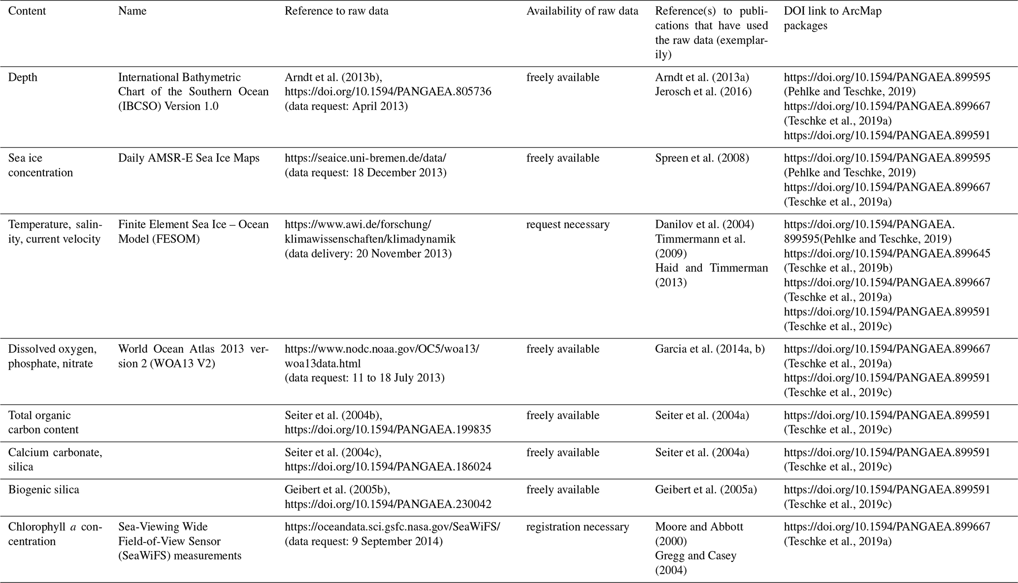
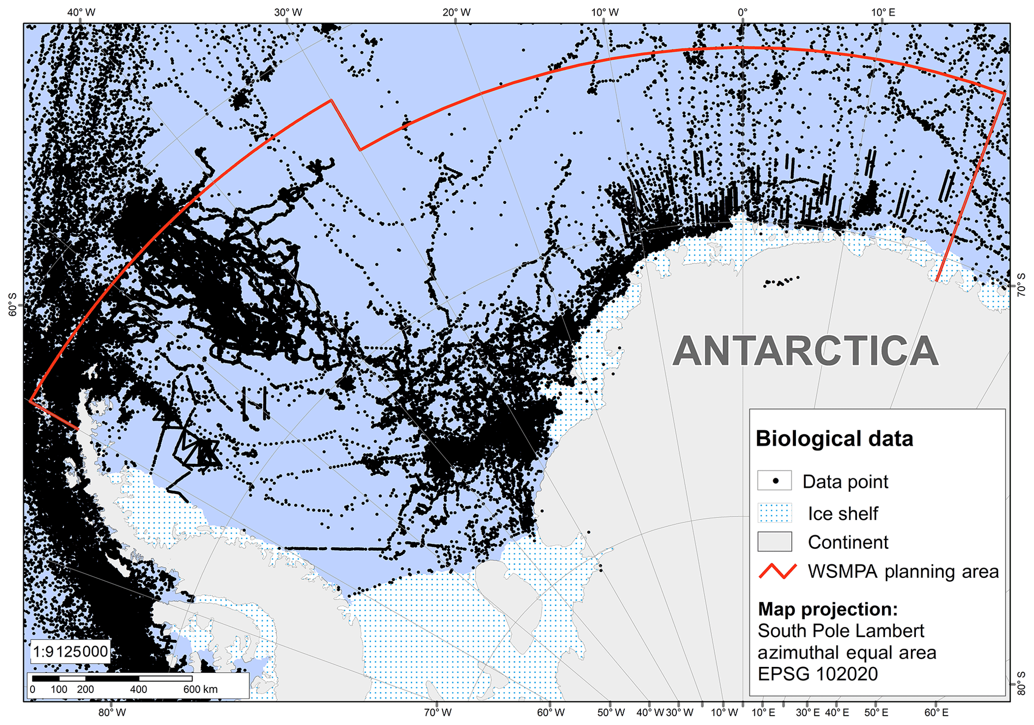
Figure 2Distribution of all data recordings across the wider Weddell Sea region compiled in the context of the WSMPA planning initiative. Figure S1 in the Supplement provides the distribution of data recordings per higher taxonomic group, i.e. zooplankton, zoobenthos, fishes, birds and pinnipeds.
In addition, we offer data layer products that we developed on the basis of the raw data sets whose sources are described here. The methods used to process and analyse the data and to develop each data layer are described in detail in the Supplement. All data layer products with a metadata description are freely available from the data publisher PANGAEA via the six persistent identifiers at https://doi.org/10.1594/PANGAEA.899595 (Pehlke and Teschke, 2019), https://doi.org/10.1594/PANGAEA.899667 (Teschke et al., 2019a), https://doi.org/10.1594/PANGAEA.899645 (Teschke et al., 2019b), https://doi.org/10.1594/PANGAEA.899591 (Teschke et al., 2019c), https://doi.org/10.1594/PANGAEA.899520 (Pehlke et al., 2019a) and https://doi.org/10.1594/PANGAEA.899619 (Pehlke et al., 2019b) (see Tables 1 and 2). The data layers are available either as ArcMap packages (as a .mxd file, containing a map document with all associated files) or as individual GIS files for those who use GIS software other than the ESRI software (ArcMap). The shape and raster files, all of which have the same spheroid (WGS 1984, EPSG 4326) and projection (South Pole Lambert Azimuthal Equal Area, EPSG 102020), were processed in such a way that they can be easily used for the analysis of MPA scenarios or other geostatistical analyses in the Weddell Sea without direct access to the underlying raw data. For example, the shape and raster files could be stacked to identify hotspots and cold spots of biodiversity, or certain layers could be used as explanatory variables in species distribution models.
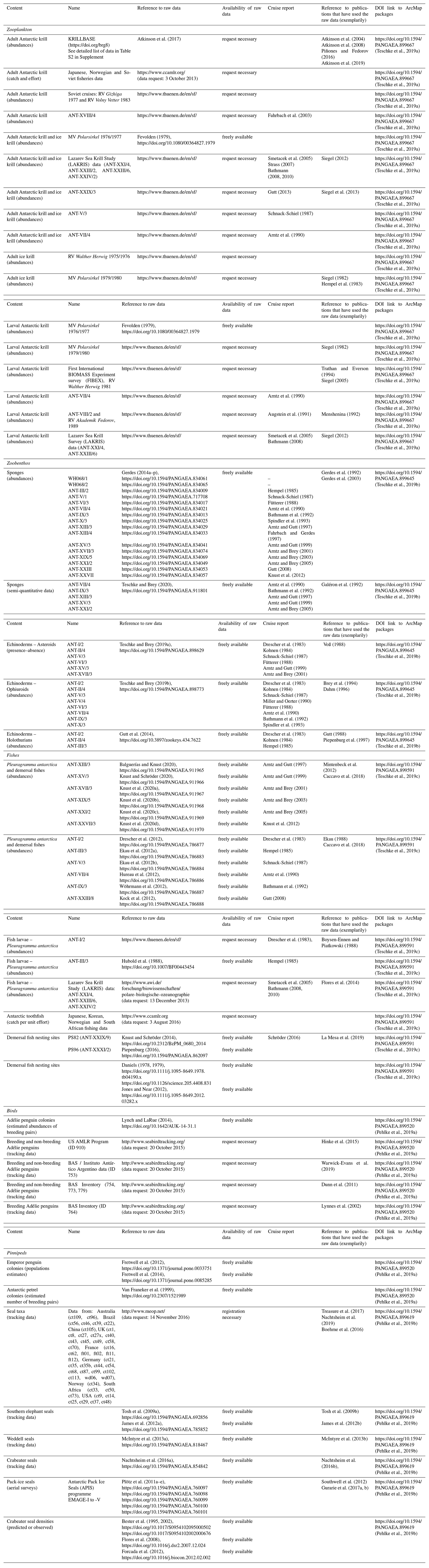
Table 2Data collection of ecological parameters compiled for the development of a marine protected area (MPA) in the wider Weddell Sea (Antarctica). For each raw data set, the name of the data source, the primary reference, such as the data portal or website on which the data are available, and the respective cruise reports and/or examples of publications that have used the respective raw data set are listed. In addition, DOI links to the final WSMPA data layer products are provided, including the respective raw data sets.
2.3 Environmental data
2.3.1 IBCSO data
The bathymetric data used in the context of the WSMPA planning initiative originate from the first regional digital bathymetric model (DBM) established in the International Bathymetric Chart of the Southern Ocean (IBCSO) Version 1.0 programme (data request: April 2013) (Table 1; Fig. 3a). This chart model is based upon bathymetric data of different origins, such as multi-beam and single-beam data; digitised depths from nautical charts; and predicted bathymetry from many hydrographic offices, scientific institutions, and data centres. The IBCSO Version 1.0 DBM has a horizontal resolution of 500 m×500 m and a vertical resolution of 1 m based on a polar stereographic projection with true scale at 65∘ referenced to the WGS84 ellipsoid (Arndt et al., 2013a, b).
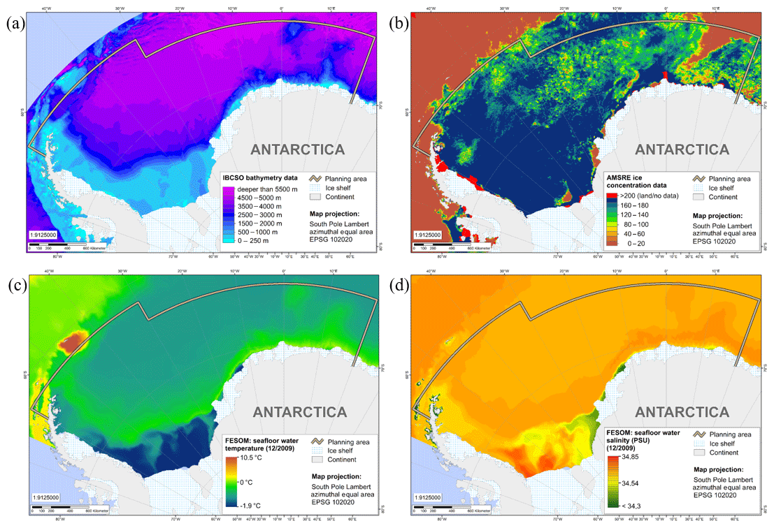
Figure 3Raster data sets of environmental parameters, which have been used as basic data in a regionalisation analysis of environmental provinces in the context of the WSMPA planning: IBCSO bathymetry (a), AMSR-E sea ice maps (exemplarily for 15 December 2009) (b), FESOM sea bottom temperature and salinity data (exemplarily for December 2009) (c, d).
2.3.2 AMSR-E sea ice maps
Daily high-resolution sea ice maps of the Antarctic Ocean are provided by the PHAROS group (PHysical Analysis of RemOte Sensing images) at the Institute of Environmental Physics, University of Bremen, Germany. The sea ice raster maps, which were used in the context of the WSMPA planning initiative, are derived from satellite observations of daily sea ice concentration by the Advanced Microwave Scanning Radiometer – Earth Observing System (AMSR-EOS) instrument on board the Aqua satellite. Daily AMSR-E sea ice maps (2013) (June 2002–October 2011) were downloaded from IUP, University of Bremen (data request: 18 December 2013) (see Table 1; Fig. 3b). The ARTIST Sea Ice (ASI) concentration algorithm was used with a spatial resolution of 6.25 km×6.25 km (Spreen et al., 2008) and a polar stereographic projection (EPSG: 3976).
2.3.3 FESOM data
Monthly mean values of seawater temperature, salinity and current velocity from 1990 to 2009 were derived from the Finite Element Sea Ice – Ocean Model (FESOM) (Table 1; Fig. 3c, d). The model run was initialised on 1 January 1980 with hydrographic data from the Polar Science Center Hydrographic Climatology (Steele et al., 2001), and forced with NCEP daily atmospheric re-analysis data (Kalnay et al., 1996) for 1980 to 2009. For more information on FESOM and the atmospheric-forcing data sets, see, e.g. Timmermann et al. (2009) and Haid and Timmermann (2013), respectively. The FESOM raster has a resolution of ; in the vertical, two z levels (i.e. sea surface and sea bottom) are used. The raster is based on the WGS84 geographic coordinate system (EPSG: 4326).
IBCSO data, AMSR-E sea ice maps and FESOM data were used in a pelagic regionalisation analysis of the Weddell Sea. The respective data layer products are available at https://doi.org/10.1594/PANGAEA.899595 (Pehlke and Teschke, 2019) (“Pelagic regionalisation – clustering approach”). The clustering approach to classifying different pelagic provinces is described in the Supplement. In addition, the data sets were used as environmental variables in various geostatistical approaches to develop spatial distribution maps for (i) adult Antarctic krill (AMSR-E), (ii) ice krill (IBCSO, FESOM), (iii) echinoderms (FESOM), (iv) demersal fish (IBCSO, FESOM), (v) Antarctic toothfish (IBCSO), (vi) Antarctic petrel (IBCSO, AMSR-E, FESOM) and (vii) emperor penguins (AMSR-E). The methods used to develop the different spatial distribution maps are described in the Supplement, and the PANGAEA link to the respective data layer products (including file names) is given in the corresponding subsection under Sect. 2.4.
2.3.4 SeaWiFS data
Near-surface chlorophyll a concentration values stem from the Sea-Viewing Wide Field-of-View Sensor (SeaWiFS) measurements on board the OrbView-2 (formerly SeaStar) spacecraft (Table 1). The monthly aggregated data (1997 to 2010) were downloaded as level 3 standard mapped images (L3SMI) with a spatial resolution of 9 km×9 km (data request: 9 September 2014).
2.3.5 WOA13 data
Data on dissolved oxygen, phosphate and nitrate were obtained from the World Ocean Atlas 2013 version 2 (WOA13 V2) (Garcia et al., 2014a, b) (Table 1). The data (1955 to 2012) were downloaded as monthly statistical means with a horizontal resolution of and 57 and 37 vertical (z) levels between 0 to 1500 and 0 to 500 m for dissolved oxygen and phosphate or nitrate, respectively. The data requests were made on 11 July 2013 (dissolved oxygen), 17 July 2013 (nitrate) and 18 July 2013 (phosphate), respectively.
2.3.6 Data on chemical sediment components
A data compilation of total organic carbon content and calcium carbonate and silica in surface sediments was downloaded from the data archive PANGAEA (Seiter et al., 2004a, b, c, and references therein) (see Table 1). Data on biogenic silica of the sediment surface were obtained from PANGAEA as well (Geibert et al., 2005b).
The data described under Sect. 2.3.4 to 2.3.6 were used as explanatory variables in the Antarctic krill species distribution model (SDM) (SeaWiFS, WOA13, chemical sediment components) and in the demersal fish SDM (WOA13, chemical sediment components). The SDMs are described in detail in the Supplement and the PANGAEA link to the respective data layer products (including file names) is given in the corresponding subsection under Sect. 2.4.
2.4 Ecological data
In the following, we describe the sources of raw data sets used in the WSMPA planning process and indicate which data layer product was developed on the basis of which raw data sets. In addition, the methods for processing and analysing the data and for developing each data layer are described in detail in the Supplement.
2.4.1 Zooplankton
Antarctic krill (adults)
The WSMPA data collection of adult Antarctic krill (Euphausia superba) originates from (i) historical UK data from “Discovery Expeditions” (1928–1939) and data collected during the SIBEX cruise by British Antarctic Survey; (ii) five South African data sets from the 1990s; (iii) four Soviet data sets from 1998 and 1990; (iv) Polish data (Witek et al., 1985); and (v) German data from location discovery cruises with MV Polarsirkel in 1979/1980 and 1980/1981 (Siegel, 1982), RV Walther Herwig cruises (1975/1976, 1977/1978), and the 2004 Lazarev Sea Krill Survey (LAKRIS) (RV Polarstern cruise ANT-XXI/4) (Siegel, 2012). All of the data are publicly available via the database KRILLBASE (2013, https://doi.org/brg8) (Atkinson et al., 2017) (see Table S2 in the Supplement, which provides a detailed list of data used from KRILLBASE). The data from KRILLBASE were complemented by abundance data on E. superba, which were collected (a) during the Norwegian Antarctic research expedition 1976/1977 (MV Polarsirkel); (b) during two Soviet research cruises in 1977 and 1983; (c) in the context of the Lazarev Sea Krill Survey; and (d) during the RV Polarstern cruises ANT-V/1-3, ANT-VII/4, ANT-XVIII/4, and ANT-XXIX/3 (Table 2). Furthermore, fisheries data on E. superba for the WSMPA Planning Area (i.e. Statistical Subarea 48.5 and the southern part of Subarea 48.6) stem from the CCAMLR database (https://www.ccamlr.org; data request: 3 October 2013) (Table 2).
All of these data were used in a species distribution model (SDM) of adult Antarctic krill and ultimately led to a data layer product showing habitat suitability for adult Antarctic krill in the WSMPA Planning Area (see https://doi.org/10.1594/PANGAEA.899667, Teschke et al., 2019a; “Adult Antarctic krill, Euphausia superba – habitat suitability prediction”).
Antarctic krill (larvae)
Abundance data on Antarctic krill larvae stem from (a) the Antarctic research expeditions 1976/1977 and 1979/1980 with MV Polarsirkel, (b) the First International BIOMASS Experiment survey (FIBEX), (c) the Lazarev Sea Krill Survey (LAKRIS), and the (d) RV Polarstern cruise ANT-VII/4 and the combined RV Polarstern (ANT-VIII/2) and RV Akademik Fedorov cruises (see Table 2).
All of the data on Antarctic krill larvae were used for an interpolation approach and led to a map of the interpolated abundances of krill larvae in the WSMPA Planning Area (see https://doi.org/10.1594/PANGAEA.899667, Teschke et al., 2019a; “Antarctic krill larvae, Euphausia superba – interpolated abundance”).
Ice krill
Abundance data on adult ice krill (Euphausia crystallorophias) originate from pelagic trawl surveys during (a) the German Antarctic research cruise 1975/1976 with RV Walther Herwig; (b) the “Pre-Site Survey” 1979/1980 with MV Polarsirkel; (c) the Lazarev Sea Krill Survey; and (d) RV Polarstern cruises ANT-V/1-3, ANT-VII/4, and ANT-XXIX/3 (Table 2).
The abundance data on E.crystallorophias were used for an interpolation approach and led to a map showing the interpolated abundances of ice krill (see https://doi.org/10.1594/PANGAEA.899667, Teschke et al., 2019a; “Ice krill, Euphausia crystallorophias – interpolated density”). In addition, the abundance data on E. crystallorophias were used for “ground truthing” of the potential ice krill habitat (https://doi.org/10.1594/PANGAEA.899667, Teschke et al., 2019a; “Ice krill, Euphausia crystallorophias – pot habitat”).
All data on E. superba and E. crystallorophias that were used, in addition to KRILLBASE and the CCAMLR database, are stored in the data warehouse of the Thünen Institute of Sea Fisheries (https://www.thuenen.de/de/sf, last access: 9 March 2020) and can be requested on demand.
2.4.2 Zoobenthos
Sponges
Abundance data and semi-quantitative data on sponges (higher taxonomic groups) that were compiled in the context of the WSMPA planning initiative, originate from zoobenthos data sets. The abundance data (Gerdes, 2014a–p) and the semi-quantitative data set (Teschke and Brey, 2020) are publicly available via PANGAEA (see Table 2).
Based on these data, we developed a map of the occurrence of sponges in the WSMPA Planning Area (https://doi.org/10.1594/PANGAEA.899645, Teschke et al., 2019b; “Sponges, Porifera – interpolated presence”).
Echinoderms
The compiled data set on echinoderms consists of presence–absence data on a species level for asteroids and abundance data on ophiuroid taxa and holothurian taxa. The first two data sets are freely available in PANGAEA (Teschke and Brey, 2019a, b), and the latter is available from the following information system: http://biodiversity.aq/ (last access: 9 March 2020) (Gutt et al., 2014).
These data were used in a clustering approach to ultimately identify the potential habitat for echinoderms in the WSMPA Planning Area by environmental proxies (https://doi.org/10.1594/PANGAEA.899645, Teschke et al., 2019b; “Special echinoderm assemblage – pot habitat”).
2.4.3 Fish
Antarctic silverfish and demersal fish
The WSMPA data collection on Antarctic silverfish larvae (Pleuragramma antarctica) originates from quantitative zooplankton data sets obtained during the RV Polarstern cruises ANT-I/2 and ANT-III/3 and during the Lazarev Sea Krill Survey (LAKRIS) (Table 2). The ANT-I/2 data are stored in the data warehouse of the Thünen Institute of Sea Fisheries and can be requested on demand (https://www.thuenen.de/de/sf). Data on fish larvae from ANT-III/3 are available from Hubold et al. (1988), and the LAKRIS data can be requested from https://www.awi.de/forschung/biowissenschaften/polare-biologische-ozeanographie (data request: 13 December 2013).
Abundance data on demersal fish and adult P. antarctica stem from benthic and pelagic trawl surveys from six RV Polarstern cruises between 1996 and 2011 (Table 2) and are published in PANGAEA (Knust, 2020 and references therein, i.e. Balguerías and Knust, 2020; Knust and Schröder, 2020; Knust et al., 2020a–d). This data compilation was complemented by data on demersal fish and P. antarctica derived from trawl and dredge surveys published in PANGAEA (Drescher et., 2012; Ekau et al., 2012a, b; Hureau et al., 2012; Kock et al., 2012; Wöhrmann et al., 2012).
All abundance data on Antarctic silverfish (adults and larvae) were used for an interpolation approach and led to a map of the interpolated abundances of P. antarctica in the WSMPA Planning Area (https://doi.org/10.1594/PANGAEA.899591, Teschke et al., 2019c; “Antarctic silverfish, Pleuragramma antarctica – interpolated abundance”).
All data on demersal fish were used in a SDM and led to a data layer product showing the habitat suitability for demersal fish in the WSMPA Planning Area (see https://doi.org/10.1594/PANGAEA.899591, Teschke et al., 2019c; “Demersal fish – habitat suitability prediction”).
Antarctic toothfish (adults)
Fishery data on the Antarctic toothfish (Dissostichus mawsoni) for the WSMPA Planning Area (i.e. Statistical Subarea 48.5 and southern part of Subarea 48.6) were taken from the CCAMLR database (https://www.ccamlr.org; data request: 3 August 2016) (Table 2).
The data were used to determine the potential habitat of D. mawsoni in the WSMPA Planning Area (see https://doi.org/10.1594/PANGAEA.899591, Teschke et al., 2019c; “Adult toothfish, Dissostichus mawsoni – pot habitat”).
Demersal fish nesting sites
Information about nesting sites of demersal fish was collected during the RV Polarstern cruises PS82 (Knust and Schröder, 2014) and PS96 (Piepenburg, 2016). The data collected during the RV Polarstern cruises were supplemented by data from the literature (Daniels, 1978, 1979; Jones and Near, 2012). The map with the locations of the nesting sites of demersal fish is available at PANGAEA (https://doi.org/10.1594/PANGAEA.899591, Teschke et al., 2019c; “Demersal fish – observation of nesting sites”) and is also shown in the Supplement (see Fig. S12).
2.4.4 Flying and non-flying seabirds
Breeding and non-breeding Adélie penguins
Tracking data on breeding and non-breeding Adélie penguins (Pygoscelis adeliae) originate from (i) British Antarctic Survey (BAS) inventory data (ID 754, 764, 773, 779), (ii) a data set from BAS and Instituto Antártico Argentino (ID 753), and (iii) a data set from the US AMLR Program (NOAA) (ID 910) (see also Table 2). All the data are stored in Birdlife International's Seabird Tracking Database (http://www.seabirdtracking.org/; data request: 20 October 2015). Adélie penguin breeding locations and estimated abundances of breeding pairs were derived from Lynch and LaRue (2014).
The tracking data on P. adeliae were used to model the probability of breeding and non-breeding P. adeliae occurrence during foraging (https://doi.org/10.1594/PANGAEA.899520, Pehlke et al., 2019a; “Breeding Adélie penguin, Pygoscelis adeliae – modelled foraging trip” and “Non-breeding Adélie penguin, Pygoscelis adeliae – modelled foraging trips”). The final data layer product for breeding P. adeliae also depicts breeding locations, estimated abundances of breeding pairs and buffer areas around each colony.
Breeding emperor penguins
Data on emperor penguin (Aptenodytes forsteri) colony locations and breeding population estimates were derived from Fretwell et al. (2012, 2014) (Table 2).
These data were used to develop a probability map of foraging areas for A. forsteri (https://doi.org/10.1594/PANGAEA.899520, Pehlke et al., 2019a; “Breeding emperor penguin, Aptenodytes forsteri – modelled foraging areas”).
Antarctic petrels
Information on breeding locations and estimated number of breeding pairs of the Antarctic petrel (Thalassoica antarctica) is published in Van Franeker et al. (1999) (Table 2).
The information on breeding pairs and their colony locations is shown in the final data layer product next to modelled foraging habitats of T. antarctica (https://doi.org/10.1594/PANGAEA.899520, Pehlke et al., 2019a; “Antarctic petrel, Thalassoica antarctica – modelled foraging areas”).
2.4.5 Pinnipeds
Tracking data from pinnipeds were obtained from the MEOP data portal “Marine Mammals Exploring the Oceans Pole to Pole” available via http://www.meop.net/ (data request: 14 November 2016) (see Table 2 for a detailed list of data used). Furthermore, the data from the MEOP data portal were complemented by tracking data sets on southern elephant seals (Tosh et al., 2009a, b; James et al., 2012a, b), Weddell seals (McIntyre et al., 2013a, b) and crabeater seals (Nachtsheim et al., 2016a, b) stored in PANGAEA.
All of these tracking data were used to model the probability of seal occurrence during foraging (https://doi.org/10.1594/PANGAEA.899619, Pehlke et al., 2019b; “Seal abundance – modelled prediction values”).
Point data from pack-ice seals (unspecified taxa) based on aerial surveys are from Plötz et al. (2011a–e) and were downloaded from PANGAEA (Table 2). These data were sampled during five flight campaigns from 1996 to 2001 within the Antarctic Pack Ice Seals (APIS) programme. Additionally, information on crabeater seal density (predicted or observed) was derived from Bester et al. (1995, 2002), Flores et al. (2008) and Forcada et al. (2012; Table 2).
All the APIS point data and information on seal densities were used to develop a map showing the distribution patterns of seals in the WSMPA Planning Area (https://doi.org/10.1594/PANGAEA.899619, Pehlke et al., 2019b; “Seal abundance – modelled and interpolated prediction values”).
Detailed information on how the data were compiled can be found in Sect. 2.2.
This is the first compilation of data sources for the Antarctic Weddell Sea and adjacent seas that considers data across the entire ecosystem, i.e. from abiotic data, such as bathymetry and sea ice, to ecological data, ranging from zooplankton and zoobenthos to fish, birds, and marine mammals. The effort to create such a compilation of data sources was directly coupled with the initiative to develop a WSMPA. However, our compilation of data sources will facilitate the future research on fauna, ecology and nature conservation in the Weddell Sea. Using our systematic overview of available data for the development of a specific data collection, future projects can avoid performing this time-consuming multi-parameter data search from scratch. In addition, our work serves to guide future studies aimed at closing data gaps in the wider Weddell Sea region and/or simply pointing to specific data sets that may be of particular interest to future generations (baseline is a particular issue). For example, some of the ecological data sets were collected in the 1980s and earlier, when the Weddell Sea was still almost pristine and hardly affected by any anthropogenic activities, thus these data sets are optimally suited to describe a reference state for assessing the effect of pressures on the Weddell Sea ecosystem. In addition, the ecological data – with a few exceptions – provide information on abundances of the respective taxa and are therefore better suited for use as an indicator for environmental changes than presence–absence data or presence data only. Ultimately, the compilation of data sources serves to motivate researchers to incorporate further data, both from existing ”paper sources” and from future measurements, into existing data repositories and archives.
Subsequent work will focus on the development of an efficient and tailor-made management system for the storage of these complex and heterogeneous data and information on WSMPA data compilation and automated data mining, handling and analysis. This system will serve three purposes: (i) to better enable a more holistic and integrative approach towards ecosystem research in the Weddell Sea in general; (ii) to enable the management of the WSMPA to carry out the tasks of the Research and Monitoring Programme as a mandatory part of an MPA under CCAMLR when adopting the MPA; and (iii) to provide key stakeholders and the public with access to data, information, and management measures related to the ecosystem of the Weddell Sea region in general and the WSMPA in particular. The CCAMLR MPA Information Repository (CMIR) currently being developed by the CCAMLR Secretariat will also be available in the future as a suitable storage location for metadata on CCAMLR MPAs in Antarctica.
The supplement related to this article is available online at: https://doi.org/10.5194/essd-12-1003-2020-supplement.
KT collected all of the data together, described the metadata and led the writing of the paper. HP took over the technical part of the data acquisition (retrieval, storage, processing). VS collected and prepared the data on zooplankton for further analyses within the WSMPA planning process. HB and RK were significantly involved in the collection of the data on pinnipeds and fishes, respectively. TB contributed to the writing of the paper.
The authors declare that they have no conflict of interest.
In particular, we would like to thank all of our colleagues from all of the national and international scientific institutions who have supported us in providing the data that we used to build up our data compilation for the wider Weddell Sea, i.e. from the Alfred Wegener Institute (Hauke Flores, Dieter Gerdes, Julian Gutt, Stefan Hain, Kerstin Jerosch, Dieter Piepenburg, Ralf Timmermann), British Antarctic Survey (Mike Dunn, Phil Trathan), CCAMLR Secretariat (Elanor Miller, Tim Jones, David Ramm), Helmholtz Centre Geesthacht (Verena Haid), Instituto Antártico Argentino (Enrique Marschoff, Mercedes Santos), National Oceanic and Atmospheric Administration (Jefferson Hinke, Wayne Trivelpiece), Royal Belgian Institute of Natural Sciences (Anton van de Putte), Stony Brook University (Heather Lynch), Thünen Institute of Sea Fisheries (Karl-Hermann Kock), University of Gothenburg (Tomas Lundälv), University of Padua (Emilio Riginella), University of St. Andrews (Lars Boehme), and Wageningen University and Research (Jan van Franeker). The marine mammal data were collected and made freely available by the International MEOP Consortium and the national programmes that contribute to it (http://www.meop.net, data request: 14 November 2016). The seal tracking data ct96 and ct109 are collected by the Integrated Marine Observing System (IMOS). IMOS is a national collaborative research infrastructure supported by the Australian Government. It is operated by a consortium of institutions as an unincorporated joint venture, with the University of Tasmania as its lead agent. We thank the two anonymous reviewers for their careful reading and constructive comments on the manuscript.
This research has been supported by the German Federal Ministry of Food and Agriculture (BMEL) through the Federal Office for Agriculture and Food (BLE) (grant no. 2813HS009).
This paper was edited by Dirk Fleischer and reviewed by two anonymous referees.
A/Conf.199/20: Report of the World Summit on Sustainable Development, Johannesburg, South Africa, 26 August–4 September, United Nations Publication, New York, 167 pp., 2002.
AMSR-E Sea Ice Maps (until 4 October 2011): available at: http://seaice.uni-bremen.de/data/amsre/asi_daygrid_swath/s6250/, data request: 18 December 2013.
Arndt, J. E., Schenke, H. W., Jakobsson, M., Nitsche, F.-O., Buys, G., Goleby, B., Rebesco, M., Bohoyo, F., Hong, J., Black, J., Greku, R., Udintsev, G., Barrios, F., Reynoso-Peralta, W., Morishita, T., and Wigley, R.: The International Bathymetric Chart of the Southern Ocean (IBCSO) Version 1.0 – A new bathymetric compilation covering circum – Antarctic waters, Geophys. Res. Lett., 40, 3111–3117, https://doi.org/10.1002/grl.50413, 2013a.
Arndt, J. E., Schenke, H. W., Jakobsson, M., Nitsche, F.-O., Buys, G., Goleby, B., Rebesco, M., Bohoyo, F., Hong, J., Black, J., Greku, R., Udintsev, G., Barrios, F., Reynoso-Peralta, W., Morishita, T., and Wigley, R.: The International Bathymetric Chart of the Southern Ocean (IBCSO) Version 1.0., PANGAEA, https://doi.org/10.1594/PANGAEA.805736, 2013b.
Arntz, W. and Brey, T.: The expedition ANTARKTIS XVII/3 (EASIZ III) of the research vessel “Polarstern” in 2000, Ber. Polar Meeresforsch., 402, 181 pp., https://doi.org/10.2312/BzPM_0402_2001, 2001.
Arntz, W. and Brey, T.: The expedition ANTARKTIS XIX/5 (LAMPOS) of the research vessel “Polarstern” in 2002, Ber. Polar Meeresforsch., 462, 120 pp., https://doi.org/10.2312/BzPM_0462_2003, 2003.
Arntz, W. and Brey, T.: The expedition ANTARKTIS XXI/2 (BENDEX) of the research vessel “Polarstern” in 2003/2004, Ber. Polar Meeresforsch., 503, 149 pp., https://doi.org/10.2312/BzPM_0503_2005, 2005.
Arntz, W. and Gutt, J.: The expedition ANTARKTIS XIII/3 (EASIZ I) of “Polarstern” to the eastern Weddell Sea in 1996, Ber. Polarforsch., 249, 148 pp., https://doi.org/10.2312/BzP_0249_1997, 1997.
Arntz, W. and Gutt, J.: The expedition ANTARKTIS XV/3 (EASIZ II) of the research vessel “Polarstern” in 1998, Ber. Polarforsch., 301, 229 pp., https://doi.org/10.2312/BzP_0301_1999, 1999.
Arntz, W., Ernst, W., and Hempel, G.: The expedition ANTARKTIS VII/4 (EPOS leg 3) and VII/5 of the research vessel “Polarstern” in 1989, Ber. Polarforsch., 68, 214 pp., https://doi.org/10.2312/BzP_0068_1990, 1990.
Arntz, W. E., Brey, T., and Gallardo V. A.: Antarctic Zoobenthos, Oceanogr. Mar. Biol., 32, 241–304, 1994.
Atkinson, A., Siegel, V., Pakhomov, E., and Rothery, P.: Long-term decline in krill stock and increase in salps within the Southern Ocean, Nature, 432, 101–103, https://doi.org/10.1038/nature02996, 2004.
Atkinson, A., Siegel, V., Pakhomov, E. A., Rothery, P., Loeb, V., Ross, R. M., Quetin, L. B., Schmidt, K., Fretwell, P., Murphy, E. J., Tarling, G. A., and Fleming, A. H.: Oceanic circumpolar habitats of Antarctic krill, Mar. Ecol. Prog. Ser., 362, 1–23, https://doi.org/10.3354/meps07498, 2008.
Atkinson, A., Hill, S. L., Pakhomov, E. A., Siegel, V., Anadon, R., Chiba, S., Daly, K. L., Downie, R., Fielding, S., Fretwell, P., Gerrish, L., Hosie, G. W., Jessopp, M. J., Kawaguchi, S., Krafft, B. A., Loeb, V., Nishikawa, J., Peat, H. J., Reiss, C. S., Ross, R. M., Quetin, L. B., Schmidt, K., Steinberg, D. K., Subramaniam, R. C., Tarling, G. A., and Ward, P.: KRILLBASE: a circumpolar database of Antarctic krill and salp numerical densities, 1926–2016, Earth Syst. Sci. Data, 9, 193–210, https://doi.org/10.5194/essd-9-193-2017, 2017.
Atkinson, A., Hill, S. L., Pakhomov, E. A., Siegel, V., Reiss, C. S., Loeb, V. J., Steinberg, D. K., Schmidt, K., Tarling, G. A., Gerrish, L., and Sailley, S. F.: Krill (Euphausia superba) distribution contracts southward during rapid regional warming, Nat. Clim. Change, 9, 142–147, https://doi.org/10.1038/s41558-018-0370-z, 2019.
Augstein, E., Bagriantsev, N., and Schenke, H. W.: The expedition ANTARKTIS VIII/1-2, 1989 with the Winter Weddel Gyre study of the research vessels “Polarstern” and “Akademik Fedorov”, Ber. Polarforsch., 84, 134 pp., https://doi.org/10.2312/BzP_0084_1991, 1991.
Balguerías, E. and Knust, R.: Fish abundances and masses from trawl samples taken in the wider Weddell Sea (Antarctica) during POLARSTERN cruise ANT-XIII/3, PANGAEA, https://doi.org/10.1594/PANGAEA.911965, 2020.
Barthel, D. and Gutt, J.: Sponge associations in the eastern Weddell Sea, Antarct. Sci., 4, 137–150, https://doi.org/10.1017/S0954102092000221, 1992.
Bathmann, U.: The expedition ANTARKTIS-XXIII/6 of the research vessel “Polarstern” in 2006, Ber. Polar Meeresforsch., 580, 175 pp., https://doi.org/10.2312/BzPM_0580_2008, 2008.
Bathmann, U.: The expedition ANTARKTIS- XXIV/2 of the research vessel “Polarstern” in 2007/2008, Ber. Polar Meeresforsch., 604, 205 pp., https://doi.org/10.2312/BzPM_0604_2010, 2010.
Bathmann, U., Schulz-Baldes, M., Fahrbach, E., Smetacek, V., and Hubberten, H. W.: The expeditions ANTARKTIS IX/1-4 of the research vessel “Polarstern” in 1990/91, Ber. Polarforsch., 100, 403 pp., https://doi.org/10.2312/BzP_0100_1992, 1992.
Bester, M. N. and Odendaal, P. N.: Abundance and distribution of Antarctic pack ice seals in the Weddell Sea, in: Antarctic Ecosystems: Models for Wider Ecological Understanding, edited by: Davison, W., Howard-Williams, C., and Broady, P., Caxton Press, Christchurch, 51–55, 2000.
Bester, M. N., Erickson, A. W., and Ferguson, J. W. H.: Seasonal change in the distribution and density of seals in the pack ice off Princess Martha Coast, Antarctica, Antarct. Sci., 7, 357–364, https://doi.org/10.1017/S0954102095000502, 1995.
Bester, M. N., Ferguson, J. W. H., and Jonker, F. C.: Population densities of pack ice seals in the Lasarev Sea, Antarctica, Antarct. Sci., 14, 123–127, https://doi.org/10.1017/S0954102002000676, 2002.
Boehme, L., Baker, A., Fedak, M., Årthun, M., Nicholls, K., Robinson, P, Costa, D., Biuw, M., and Photopoulou, T.: Bimodal winter haul-out patterns of adult Weddell seals (Leptonychotes weddellii) in the Southern Weddell Sea, PLoS ONE, 11, e0155817, https://doi.org/10.1371/journal.pone.0155817, 2016.
Boysen-Ennen, E. and Piatkowski, U.: Meso- and macrozooplankton communities in the Weddell Sea, Antarctica, Polar Biol., 9, 17–35, https://doi.org/10.1007/BF00441761, 1988.
Brandt, A., Gooday, A. J., Brix, S. B., Brökeland, W., Cedhagen, T., Choudhury, M., Cornelius, N., Danis, B., De Mesel, I., Diaz, R. J., Gillan, D. C., Ebbe, B., Howe, J., Janussen, D., Kaiser, S., Linse, K., Malyutina, M., Brandao, S., Pawlowski, J., Raupach, M., and Vanreusel, A.: The Southern Ocean deep sea: first insights into biodiversity and biogeography, Nature, 447, 307–311, https://doi.org/10.1038/nature05827, 2007.
Brey, T., Klages, M., Dahm, C., Gorny, M., Gutt, J., Hain, S., Stiller, M., and Arntz, W. E.: Antarctic benthic diversity, Nature, 368, p. 297, https://doi.org/10.1038/368297a0, 1994.
Caccavo, J. A., Papetti, C., Wetjen, M., Knust, R., Ashford, J. R., and Zanel, L.: Along-shelf connectivity and circumpolar gene flow in Antarctic silverfish (Pleuragramma antarctica), Sci. Rep., 8, 17856, https://doi.org/10.1038/s41598-018-36030-x, 2018.
CCAMLR-XXXVII/31: Proposal on a conservation measure establishing a marine protected area in the Domain 1 (Western Antarctic Peninsula and South Scotia Arc), Delegations of Argentina and Chile, CAMLR Commission Meeting, Hobart, Australia, 27 pp., 22 October to 2 November 2018.
Clarke, A. and Johnston, N. M.: Antarctic marine benthic diversity, Oceanogr. Mar. Biol., 41, 47–114, 2003.
Convention on Biological Diversity (CBD): CBD, COP 10 Decision X/2, available at: http://www.cbd.int/decision/cop/?id=12268 (last access: 16 April 2020), 2010.
Dahm, C.: Ecology and population dynamics of Antarctic ophiuroids (Echinodermata), Ber. Polarforsch., 194, 289 pp., https://doi.org/10.2312/BzP_0194_1996, 1996.
Daniels, R. A.: Nesting Behaviour of Harpagifer bispinis in Arthur Harbour, Antarctic Peninsula, J. Fish. Biol., 12, 465–474, https://doi.org/10.1111/j.1095-8649.1978.tb04190.x, 1978.
Daniels, R. A.: Nest guard replacement in the Antarctic fish Harpagifer bispinis: Possible altruistic behaviour, Science, 205, 831–833, https://doi.org/10.1126/science.205.4408.831, 1979.
Danilov, S., Kivman, G., and Schröter, J.: A finite element ocean model: principles and evaluation, Ocean Model., 6, 125–150, https://doi.org/10.1016/S1463-5003(02)00063-X, 2004.
Drescher, E., Hubold, G., Piatkowski, U., Plötz, J., and Voß, J.: Das biologische Programm der Antarktis-I-Expedition mit FS “Polarstern”: Stationslisten der Plankton-, Benthos- und Grundschleppnetzfänge und Liste der Probennahme an Robben und Vögeln, Ber. Polarforsch., 12, 34 pp., https://doi.org/10.2312/BzP_0012_1983, 1983.
Drescher, H.-E., Hubold, G., Piatkowski, U., Plötz, J., Voß, J., Kock, K.- H., and Gutt, J.: Counts of fish species from trawl and dredge samples in the eastern Weddell Sea and at the Antarctic Peninsula during POLARSTERN cruise ANT-I/2, PANGAEA, https://doi.org/10.1594/PANGAEA.786877, 2012.
Dunn, M. J., Silk, J. R. D., and Trathan, P. N.: Post-breeding dispersal of Adélie penguins (Pygoscelis adeliae) nesting at Signy Island, South Orkney Islands, Polar Biol., 34, 205–214, https://doi.org/10.1007/s00300-010-0870-4, 2011.
Ekau, W.: Ecomorphology of nototheniid fish from the Weddell Sea, Antarctica, Rep. Polar Res., 51, 140 pp., https://doi.org/10.2312/BzP_0051_1988, 1988.
Ekau, W., Hubold, G., Kock, K.-H., and Gutt, J.: Counts of fish species from trawl and dredge samples in the eastern Weddell Sea and at the Antarctic Peninsula during POLARSTERN cruise ANT-III/3, PANGAEA, https://doi.org/10.1594/PANGAEA.786883, 2012a.
Ekau, W., Hubold, G., Wöhrmann, A. P. A., Kock, K.-H., and Gutt, J.: Counts of fish species from trawl and dredge samples in the eastern Weddell Sea and at the Antarctic Peninsula during POLARSTERN cruise ANT-V/3, PANGAEA, https://doi.org/10.1594/PANGAEA.786884, 2012b.
Fahrbach, E. and Gerdes, D.: The expedition ANTARKTIS XIII/4-5 of the research vessel “Polarstern” in 1996, Ber. Polarforsch., 239, 126 pp., https://doi.org/10.2312/BzP_0239_1997, 1997.
Fahrbach, E., Fütterer D., El Naggar, S., and Oerter, H.: The expedition ANTARKTIS XVIII/3-4 of the research vessel “Polarstern” in 2000/2001 including operations on land and at the Neumayer Station, Ber. Polarforsch. Meeresforsch., 445, 164 pp., https://doi.org/10.2312/BzPM_0445_2003, 2003.
Fevolden, S. E.: Investigations on krill (Euphausiacea), sampled during the Norwegian Antarctic Research Expedition 1976/77, Sarsia, 64, 189–198, https://doi.org/10.1080/00364827.1979.10411381, 1979.
Flores, H., Haas C., van Franeker, J. A., and Meesters, E.: Density of pack-ice seals and penguins in the western Weddell Sea in relation to ice thickness and ocean depth, Deep-Sea Res. Pt. II, 55, 1068–1074, https://doi.org/10.1016/j.dsr2.2007.12.024, 2008.
Flores, H., Hunt, B. P. V., Kruse, S., Pakhomov, E. A., Siegel, V., van Franeker, J. A., Strass, V., Van de Putte, A. P., Meesters E. H. W. G., and Bathmann, U.: Seasonal changes in the vertical distribution and community structure of Antarctic macrozooplankton and micronekton, Deep-Sea Res. Pt. I, 84, 127–141, https://doi.org/10.1016/j.dsr.2013.11.001, 2014.
Forcada, J., Trathan, P. N., Boveng, P. L., Boyd, I. L., Burns, J. M., Costa, D. P., Fedak, M., Rogers, T. L., and Southwell, C. J.: Responses of Antarctic pack-ice seals to environmental change and increasing krill fishing, Biol. Conserv., 149, 40–50, https://doi.org/10.1016/j.biocon.2012.02.002, 2012.
Fretwell, P. T., LaRue, M. A., Morin, P., Kooyman, G. L., Wienecke, B., Ratcliffe, N., Fox, A. J., Fleming, A. H., Porter, C., and Trathan, P. N.: An Emperor Penguin Population Estimate: The First Global, Synoptic Survey of a Species from Space, PLoS ONE, 7, e33751, https://doi.org/10.1371/journal.pone.0033751, 2012.
Fretwell, P. T., Trathan P. N., Wienecke, B., and Kooyman, G. L.: Emperor penguins breeding on iceshelves, PLoS ONE, 9, e85285, https://doi.org/10.1371/journal.pone.0085285, 2014.
Fütterer, D.: The expedition ANTARKTIS-VI of the research vessel “Polarstern” in 1987/1988, Ber. Polarforsch., 58, 267 pp., https://doi.org/10.2312/BzP_0058_1988, 1988.
Galéron, J., Herman, R. L., Arnaud, P. M., Arntz, W. E., Hain, S., and Klages, M.: Macrofaunal communities on the continental shelf and slope of the southeastern Weddell Sea, Antarctica, Polar Biol., 12, 283–290, https://doi.org/10.1007/BF00238271, 1992.
Garcia, H. E., Locarnini, R. A., Boyer, T. P., Antonov, J. I., Baranova, O. K., Zweng, M. M., Reagan, J. R., and Johnson, D. R.: World Ocean Atlas 2013, Volume 3: Dissolved Oxygen, Apparent Oxygen Utilization, and Oxygen Saturation, in: NOAA Atlas NESDIS, edited by: Levitus, S. and Mishonov, A., 75, 27 pp., 2014a.
Garcia, H. E., Locarnini, R. A., Boyer, T. P., Antonov, J. I., Baranova, O. K., Zweng, M. M., Reagan, J. R., and Johnson, D. R.: World Ocean Atlas 2013, Volume 4: Dissolved Inorganic Nutrients (phosphate, nitrate, silicate), in: NOAA Atlas NESDIS, edited by: Levitus, S. and Mishonov, A., 76, 25 pp., 2014b.
Geibert, W., Rutgers van der Loeff, M., Usbeck, R., Gersonde, R., Kuhn, G., and Seeberg-Elverfeldt, J.: Quantifying the opal belt in the Atlantic and southeast Pacific sector of the Southern Ocean by means of 230Th normalization, Global Biogeochem. Cy., 19, GB4001, https://doi.org/10.1029/2005GB002465, 2005a.
Geibert, W., Rutgers van der Loeff, M., Usbeck, R., Gersonde, R., Kuhn, G., and Seeberg-Elverfeldt, J.: Accumulation rates of bulk sediment and opal in surface sediments of the South Atlantic, PANGAEA, https://doi.org/10.1594/PANGAEA.230042, 2005b.
Gerdes, D.: Abundance of macrozoobenthos in surface sediments sampled during Walther Herwig II cruise WH068/1, Alfred Wegener Institute, Helmholtz Centre for Polar and Marine Research, Bremerhaven, PANGAEA, https://doi.org/10.1594/PANGAEA.834061, 2014a.
Gerdes, D.: Abundance of macrozoobenthos in surface sediments sampled during Walther Herwig II cruise WH068/2, Alfred Wegener Institute, Helmholtz Centre for Polar and Marine Research, Bremerhaven, PANGAEA, https://doi.org/10.1594/PANGAEA.834065, 2014b.
Gerdes, D.: Abundance of macrozoobenthos in surface sediments sampled during POLARSTERN cruise ANT-III/2, Alfred Wegener Institute, Helmholtz Centre for Polar and Marine Research, Bremerhaven, PANGAEA, https://doi.org/10.1594/PANGAEA.834009, 2014c.
Gerdes, D.: Abundance of macrozoobenthos in surface sediments sampled during POLARSTERN cruise ANT-V/1, Alfred Wegener Institute, Helmholtz Centre for Polar and Marine Research, Bremerhaven, PANGAEA, https://doi.org/10.1594/PANGAEA.717708, 2014d.
Gerdes, D.: Abundance of macrozoobenthos in surface sediments sampled during POLARSTERN cruise ANT-VI/3, Alfred Wegener Institute, Helmholtz Centre for Polar and Marine Research, Bremerhaven, PANGAEA, https://doi.org/10.1594/PANGAEA.834017, 2014e.
Gerdes, D.: Abundance of macrozoobenthos in surface sediments sampled during POLARSTERN cruise ANT-VII/4, Alfred Wegener Institute, Helmholtz Centre for Polar and Marine Research, Bremerhaven, PANGAEA, https://doi.org/10.1594/PANGAEA.834021, 2014f.
Gerdes, D.: Abundance of macrozoobenthos in surface sediments sampled during POLARSTERN cruise ANT-IX/3, Alfred Wegener Institute, Helmholtz Centre for Polar and Marine Research, Bremerhaven, PANGAEA, https://doi.org/10.1594/PANGAEA.834013, 2014g.
Gerdes, D.: Abundance of macrozoobenthos in surface sediments sampled during POLARSTERN cruise ANT-X/3, Alfred Wegener Institute, Helmholtz Centre for Polar and Marine Research, Bremerhaven, PANGAEA, https://doi.org/10.1594/PANGAEA.834025, 2014h.
Gerdes, D.: Abundance of macrozoobenthos in surface sediments sampled during POLARSTERN cruise ANT-XIII/3, Alfred Wegener Institute, Helmholtz Centre for Polar and Marine Research, Bremerhaven, PANGAEA, https://doi.org/10.1594/PANGAEA.834029, 2014i.
Gerdes, D.: Abundance of macrozoobenthos in surface sediments sampled during POLARSTERN cruise ANT-XIII/4, Alfred Wegener Institute, Helmholtz Centre for Polar and Marine Research, Bremerhaven, PANGAEA, https://doi.org/10.1594/PANGAEA.834033, 2014j.
Gerdes, D.: Abundance of macrozoobenthos in surface sediments sampled during POLARSTERN cruise ANT-XV/3, Alfred Wegener Institute, Helmholtz Centre for Polar and Marine Research, Bremerhaven, PANGAEA, https://doi.org/10.1594/PANGAEA.834041, 2014k.
Gerdes, D.: Abundance of macrozoobenthos in surface sediments sampled during POLARSTERN cruise ANT-XVII/3 (EASIZ III), Alfred Wegener Institute, Helmholtz Centre for Polar and Marine Research, Bremerhaven, PANGAEA, https://doi.org/10.1594/PANGAEA.834074, 2014l.
Gerdes, D.: Abundance of macrozoobenthos in surface sediments sampled during POLARSTERN cruise ANT-XIX/5, Alfred Wegener Institute, Helmholtz Centre for Polar and Marine Research, Bremerhaven, PANGAEA, https://doi.org/10.1594/PANGAEA.834069, 2014m.
Gerdes, D.: Abundance of macrozoobenthos in surface sediments sampled during POLARSTERN cruise ANT-XXI/2, Alfred Wegener Institute, Helmholtz Centre for Polar and Marine Research, Bremerhaven, PANGAEA, https://doi.org/10.1594/PANGAEA.834049, 2014n.
Gerdes, D.: Abundance of macrozoobenthos in surface sediments sampled during POLARSTERN cruise ANT-XXIII/8, Alfred Wegener Institute, Helmholtz Centre for Polar and Marine Research, Bremerhaven, PANGAEA, https://doi.org/10.1594/PANGAEA.834053, 2014o.
Gerdes, D.: Abundance of macrozoobenthos in surface sediments sampled during POLARSTERN cruise ANT-XXVII/3, Alfred Wegener Institute, Helmholtz Centre for Polar and Marine Research, Bremerhaven, PANGAEA, https://doi.org/10.1594/PANGAEA.834057, 2014p.
Gerdes, D., Klages, M., Arntz, W. E., Herman, R. L., Galéron, J., and Hain, S.: Quantitative investigations on macrobenthos communities of the southeastern Weddell Sea shelf based on multibox corer samples, Polar Biol., 12, 291–30, https://doi.org/10.1007/BF00238272, 1992.
Gerdes, D., Hilbig, B., and Montiel, A.: Impact of iceberg scouring on macrobenthic communities in the high-Antarctic Weddell Sea, Polar Biol., 26, 295–301, https://doi.org/10.1007/s00300-003-0484-1, 2003.
Gregg, W. W. and Casey, N. W.: Global and regional evaluation of the SeaWiFS chlorophyll data set, Remote Sens. Environ., 93, 463–479, https://doi.org/10.1016/j.rse.2003.12.012, 2004.
Gurarie, E., Bengtson, J. L., Bester, M. N., Blix, A. S., Cameron, M., Bornemann, H., Nordøy, E., Plötz, J., Steinhage, D., and Boveng, P.: Distribution, density and abundance of Antarctic ice seals off Queen Maud Land and the eastern Weddell Sea, Polar Biol., 40, 1149–1165, https://doi.org/10.1007/s00300-016-2029-4, 2017a.
Gurarie, E., Bengtson, J. L., Bester, M. N., Blix, A. S., Cameron, M., Bornemann, H., Nordøy, E., Plötz, J., Steinhage, D., and Boveng, P.: Erratum to: Distribution, density and abundance of Antarctic ice seals off Queen Maud Land and the eastern Weddell Sea, Polar Biol., 40, 1167–1168, https://doi.org/10.1007/s00300-016-2050-7, 2017b.
Gutt, J.: On the Distribution and ecology of sea cucumbers (Holothuroidea, Echinodermata) in the Weddell Sea (Antarctica), Ber. Polarforsch., 41, 87 pp., https://doi.org/10.2312/BzP_0041_1988, 1988.
Gutt, J.: The Expedition ANTARKTIS-XXIII/8 of the research vessel “Polarstern” in 2006/2007, Ber. Polarforsch., 569, 153 pp., https://doi.org/10.2312/BzPM_0569_2008, 2008.
Gutt, J.: The expedition ANTARKTIS-XXIX/3 of the research vessel “Polarstern” in 2013, Ber. Polarforsch., 665, 151 pp., https://doi.org/10.2312/BzPM_0665_2013, 2013.
Gutt, J., Piepeburg, D., and Voß, J: Asteroids, ophiuroids and holothurians from the southeastern Weddell Sea (Southern Ocean), ZooKeys, 434, 1–15, https://doi.org/10.3897/zookeys.434.7622, 2014.
Haid, V. and Timmermann, R.: Simulated heat flux and sea ice production at coastal polynyas in the southwestern Weddell Sea, J. Geophys. Res.-Oceans, 118, 2640–2652, https://doi.org/10.1002/jgrc.20133, 2013.
Hempel, G.: Die Expedition ANTARKTIS-III mit FS “Polarstern” 1984/85, Ber. Polarforsch., 25, 209 pp., https://doi.org/10.2312/BzP_0025_1985, 1985.
Hempel, I., Hubold, G., and Kaczmaruk, B.: Distribution of some groups of zooplankton in the inner Weddell Sea in summer 1979/80, Ber. Polarforsch., 9, 35 pp., https://doi.org/10.2312/BzP_0009_1983, 1983.
Hinke, J. T., Polito, M. J., Goebel, M. E., Jarvis, S., Reiss, C. S., Thorrold, S. R., Trivelpiee, W. Z., and Watters, G. M.: Spatial and isotopic niche partitioning during winter in chinstrap and Adélie penguins from the South Shetland Islands, Ecosphere, 6, 125, https://doi.org/10.1890/ES14-00287.1, 2015.
Hubold, G., Hempel, I., and Meyer, M.: Zooplankton communities in the southern Weddell Sea (Antarctica), Polar Biol., 8, 225–233, https://doi.org/10.1007/BF00443454, 1988.
Hureau, J.-C., Balguerías, E., Duhamel, G., Kock, K.-H., Ozouf-Costaz, C., White, M., and Gutt, J.: Counts and mass of fish species from trawl and dredge samples in the eastern Weddell Sea during POLARSTERN cruise ANT-VII/4, PANGAEA, https://doi.org/10.1594/PANGAEA.786886, 2012.
James, B. C., McIntyre, T., Tosh, C. A., Bornemann, H., Plötz, J., and Bester, M. N.: Dive depth frequency of 23 adult male southern elephant seals (Mirounga leonina) from Marion Island and King George Island, PANGAEA, https://doi.org/10.1594/PANGAEA.785852, 2012a.
James, B. S., McIntyre, T., Tosh, C. A., Bornemann, H., Plötz, J., and Bester, M. N.: Inter-population differences in diving behaviour of adult male southern elephant seals (Mirounga leonina), Polar Biol., 35, 1759–1766, https://doi.org/10.1007/s00300-012-1214-3, 2012b.
Jerosch, K., Kuhn, G., Krajnik, I., Scharf, F., and Dorschel, B.: A geomorphological seabed classification for the Weddell Sea, Antarctica, Mar. Geophys. Res., 37, 127–141, https://doi.org/10.1007/s11001-015-9256-x, 2016.
Jones, C. D. and Near, T. J.: The reproductive behaviour of Pogonophryne scotti confirms widespread egg-guarding parental care among Antarctic notothenioids, J. Fish Biol., 80, 2629–2635, https://doi.org/10.1111/j.1095-8649.2012.03282.x, 2012.
Kalnay, E., Kanamitsu, M., Kistler, R., Collins, W., Deaven, D., Gandin, L., Iredell, M., Saha, S., White, G., Woollen, J., Zhu, Y., Chelliah, M., Ebisuzaki, W., Higgins, W., Janowiak, J., Mo, K. C., Ropelewski, C., Wang, J., Leetmaa, A., Reynolds, R., Jenne, R., and Joseph, D.: The NCEP/NCAR 40-year reanalysis project, B. Am. Meteorol. Soc., 77, 437–471, 1996.
Knust, R.: Fish abundances and masses from trawl samples taken in the wider Weddell Sea (Antarctica), PANGAEA, https://doi.org/10.1594/PANGAEA.911972, 2020.
Knust, R. and Schröder, M.: The expedition PS82 of the research vessel “Polarstern” to the southern Weddell Sea in 2013/2014, Ber. Polarforsch., 680, 155 pp., https://doi.org/10.2312/BzPM_0680_2014, 2014.
Knust, R. and Schröder, A.: Fish abundances and masses from trawl samples taken in the wider Weddell Sea (Antarctica) during POLARSTERN cruises ANT-XV/3, PANGAEA, https://doi.org/10.1594/PANGAEA.911966, 2020.
Knust, R., Gerdes, D., and Mintenbeck, K.: The expedition ANTARKTIS-XXVII/3 of the research vessel “Polarstern” in 2011 (CAMBIO), Ber. Polarforsch., 644, 202 pp., https://doi.org/10.2312/BzPM_0644_2012, 2012.
Knust, R., Mintenbeck, K., and Schröder, A.: Fish abundances and masses from trawl samples taken in the wider Weddell Sea (Antarctica) during POLARSTERN cruise ANT-XVII/3, PANGAEA, https://doi.org/10.1594/PANGAEA.911967, 2020a.
Knust, R., Brodte, E.-M., and Mintenbeck, K.: Fish abundances and masses from trawl samples taken in the wider Weddell Sea (Antarctica) during POLARSTERN cruise ANT-XIX/5, PANGAEA, https://doi.org/10.1594/PANGAEA.911968, 2020b.
Knust, R., Brodte, E.-M., and Mintenbeck, K.: Fish abundances and masses from trawl samples taken in the wider Weddell Sea (Antarctica) during POLARSTERN cruise ANT-XXI/2, PANGAEA, https://doi.org/10.1594/PANGAEA.911969, 2020c.
Knust, R., Mintenbeck, K., Hirse, T., Koschnick, N., Damerau, M., and Matchiner, M.: Fish abundances and masses from trawl samples taken in the wider Weddell Sea (Antarctica) during POLARSTERN cruise ANT-XXVII/3, PANGAEA, https://doi.org/10.1594/PANGAEA.911970, 2020d.
Kock, K.-H., Busch, M., Holst, M., Klimpel, S., Pietschok, D., Pshenichnov, L., Riehl, R., Schöling, S., and Gutt, J.: Counts and mass of fish species from trawl samples in the western Weddell Sea during POLARSTERN cruise ANT-XXIII/8, PANGAEA, https://doi.org/10.1594/PANGAEA.786888, 2012.
Kohnen, H.: Die Expedition Antarktis-II mit FS “Polarstern” 1983/84: Bericht vom Fahrtabschnitt 4 Punta – Arenas – Kapstadt (ANT-II/4); mit Beiträgen der Fahrtteilnehmer, Ber. Polarforsch., 19, 185 pp., https://doi.org/10.2312/BzP_0019_1984, 1984.
KRILLBASE: A database of Antarctic krill and salp densities in the Southern Ocean, 1926 to 2016, available at: https://www.bas.ac.uk/project/krillbase/#data, data request: 26 September 2013.
La Mesa, M., Piepenburg, D., Pineda-Metz, S. E. A., Riginella, E., and Eastman, J. T.: Spatial distribution and habitat preferences of demersal fish assemblages in the southeastern Weddell Sea (Southern Ocean), Polar Biol., 42, 1025–1040, https://doi.org/10.1007/s00300-019-02495-3, 2019.
Linse, K., Griffiths, H. J., Barnes, D. K. A., and Clarke, A.: Biodiversity and biogeography of Antarctic and Sub-Antarctic Mollusca, Deep-Sea Res. Pt. II, 53, 985–1008, https://doi.org/10.1016/j.dsr2.2006.05.003, 2006.
Lynch, H. J. and LaRue, M. A.: First global census of the Adélie Penguin, Auk, 131, 457–66, https://doi.org/10.1642/AUK-14-31.1, 2014.
Lynnes, A. S., Reid, K., Croxall, J. P., and Trathan, P. N.: Conflict or co-existence? Foraging distribution and competition for prey between Adélie and chinstrap penguins, Mar. Biol., 141, 1165–1174, https://doi.org/10.1007/s00227-002-0899-1, 2002.
Marine Mammals Exploring the Oceans Pole to Pole: available at: http://www.meop.net/, data request: 14 November 2016.
McDermott, G. R., Meng, K. C., McDonald, G. G., and Costello, C. J.: The blue paradox: Preemptive overfishing in marine reserves, P. Natl. Acad. Sci. USA, 116, 5319–5325, https://doi.org/10.1073/pnas.1802862115, 2018.
McIntyre, T., Stansfield, L. J., Bornemann, H., Plötz, J., and Bester, M. N.: Hydrographic data from Atka Bay taken by Weddell seals during expedition NEU2008 with links to datasets, PANGAEA, https://doi.org/10.1594/PANGAEA.818467, 2013a.
McIntyre, T., Stansfield, L. J., Bornemann, H., Plötz, J., and Bester, M. N.: Hydrographic influences on the summer dive behaviour of Weddell seals (Leptonychotes weddellii) in Atka Bay, Antarctica, Polar Biol., 36, 1693–1700, https://doi.org/10.1007/s00300-013-1384-7, 2013b.
Menshenina L.: Distribution of Euphausiid larvae in the Weddell Gyre in September-October 1989, Proc. NIPR Symp. Polar Biol., 5, 44–54, 1992.
Miller, H. and Oerter, H.: The expedition ANTARKTIS-V of RV “POLARSTERN” 1986/87: report of legs ANT-V/4-5, Ber. Polarforsch., 57, 206 pp., https://doi.org/10.2312/BzP_0057_1990, 1990.
Mintenbeck, K., Barrera-Oro, E. R., Brey, T., Jacob, U., Knust, R., Mark, F. C., Moreira, E., Strobel, A., and Arntz, W. E.: Impact of Climate Change on Fishes in Complex Antarctic Ecosystems, in: Global Change in Multispecies Systems Part 1, Advances in Ecological Research, edited by: Jacob, U. and Woodward, G., Elsevier Ltd. Academic Press, Burlington, Massachusetts, 46, 351-426, https://doi.org/10.1016/B978-0-12-396992-7.00006-X, 2012.
Moore, J. K. and Abbott, M. R.: Phytoplankton chlorophyll distributions and primary production in the Southern Ocean, J. Geophys. Res., 105, 709–722, https://doi.org/10.1029/1999JC000043, 2000.
Mora, C. and Sale, P. F.: Ongoing global biodiversity loss and the need to move beyond protected areas: a review of the technical and practical shortcomings of protected areas on land and sea, Mar. Ecol. Prog. Ser., 434, 251–266, https://doi.org/10.3354/meps09214, 2011.
Nachtsheim, D. A., Jerosch, K., Hagen, W., Plötz, J., and Bornemann, H.: Crabeater seals (Lobodon carcinophaga) in the Weddell Sea during DRE1998 campaign, PANGAEA, https://doi.org/10.1594/PANGAEA.854842, 2016a.
Nachtsheim, D. A., Jerosch, K., Hagen, W., Plötz, J., and Bornemann, H.: Habitat modelling of crabeater seals (Lobodon carcinophaga) in the Weddell Sea using the multivariate approach Maxent, Polar Biol., 40, 961–976, https://doi.org/10.1007/s00300-016-2020-0, 2016b.
Nachtsheim, D. A., Ryan, S., Schröder, M., Jensen, L., Oosthuizen, W. C., Bester, M. N., Hagen, W., and Bornemann, H.: Foraging behaviour of Weddell seals (Leptonychotes weddellii) in connection to oceanographic conditions in the southern Weddell Sea, Prog. Oceanogr., 173, 165–179, https://doi.org/10.1016/j.pocean.2019.02.013, 2019.
Pehlke, H. and Teschke, K.: Pelagic regionalisation approach in the wider Weddell Sea (Antarctica) with link to ArcGIS map package, PANGAEA, https://doi.org/10.1594/PANGAEA.899595, 2019.
Pehlke, H., Brey, T., and Teschke, K.: Spatial distribution of a flying seabird (Antarctic petrel) and penguins (Adélie penguin, Emperor penguin) in the wider Weddell Sea (Antarctica) with links to ArcGIS map packages, PANGAEA, https://doi.org/10.1594/PANGAEA.899520, 2019a.
Pehlke, H., Brey, T., and Teschke, K.: Spatial distribution of seals in the wider Weddell Sea (Antarctica) with links to ArcGIS map packages, PANGAEA, https://doi.org/10.1594/PANGAEA.899619, 2019b.
Piepenburg, D.: Seabed photographs taken along OFOS profiles during POLARSTERN cruise PS96 (ANT-XXXI/2 FROSN), Alfred Wegener Institute, Helmholtz Centre for Polar and Marine Research, Bremerhaven, PANGAEA, https://doi.org/10.1594/PANGAEA.862097, 2016.
Piepenburg, D., Voß, J., and Gutt, J.: Assemblages of sea stars (Echinodermata: Asteroidea) and brittle stars (Echinodermata: Ophiuroidea) in the Weddell Sea (Antarctica) and off Northeast Greenland (Arctic): a comparison of diversity and abundance, Polar Biol., 17, 305–322, https://doi.org/10.1007/PL00013372, 1997.
Piňones, A. and Fedorov, A. V.: Projected changes of Antarctic krill habitat by the end of the 21st century, Geophys. Res. Lett., 43, 8580–8589, https://doi.org/10.1002/2016GL069656, 2016.
Plötz, J., Steinhage, D., and Bornemann, H.: Seal census raw data during campaign EMAGE-I. Alfred Wegener Institute, Helmholtz Center for Polar and Marine Research, Bremerhaven, PANGAEA, https://doi.org/10.1594/PANGAEA.760097, 2011a.
Plötz, J., Steinhage, D., and Bornemann, H.: Seal census raw data during campaign EMAGE-II. Alfred Wegener Institute, Helmholtz Center for Polar and Marine Research, Bremerhaven, PANGAEA, https://doi.org/10.1594/PANGAEA.760098, 2011b.
Plötz, J., Steinhage, D., and Bornemann, H.: Seal census raw data during campaign EMAGE-III. Alfred Wegener Institute, Helmholtz Center for Polar and Marine Research, Bremerhaven, PANGAEA, https://doi.org/10.1594/PANGAEA.760099, 2011c.
Plötz, J., Steinhage, D., and Bornemann, H.: Seal census raw data during campaign EMAGE-IV. Alfred Wegener Institute, Helmholtz Center for Polar and Marine Research, Bremerhaven, PANGAEA, https://doi.org/10.1594/PANGAEA.760100, 2011d.
Plötz, J., Steinhage, D., and Bornemann, H.: Seal census raw data during campaign EMAGE-V. Alfred Wegener Institute, Helmholtz Center for Polar and Marine Research, Bremerhaven, PANGAEA, https://doi.org/10.1594/PANGAEA.760101, 2011e.
SC-CAMLR-XXX: Report of the thirtieth meeting of the Scientific Committee, Annex 6 (Report of the Workshop on Marine Protected Areas), 259–311, Hobart, Australia, 24–28 October 2011.
Schnack-Schiel, S.: The Winter-Expedition of RV “Polarstern” to the Antarctic (ANT V/1-3), Ber. Polarforsch., 39, 259 pp., https://doi.org/10.2312/BzP_0039_1987, 1987.
Schröder, M.: The expedition PS96 of the research vessel “Polarstern” to the southern Weddell Sea in 2015/2016, Ber. Polarforsch., 700, 142 pp., https://doi.org/10.2312/BzPM_0700_2016, 2016.
Seabird Tracking Database: available at: http://seabirdtracking.org/, data request: 20 October 2015.
Seiter, K., Hensen, C., Schröter, J., and Zabel, M.: Organic carbon content in surface sediments-defining regional provinces, Deep-Sea Res. Pt. I, 51, 2001–2026, https://doi.org/10.1016/j.dsr.2004.06.014, 2004a.
Seiter, K., Hensen, C., Schröter, J., and Zabel, M.: Total organic carbon content in surface sediments, a compilation from different sources, PANGAEA, https://doi.org/10.1594/PANGAEA.199835, 2004b.
Seiter, K., Hensen, C., Schröter, J., and Zabel, M.: Global data compilation of benthic data sets I, PANGAEA, https://doi.org/10.1594/PANGAEA.186024, 2004c.
Siegel, V.: Investigations on krill (Euphausia superba) in the southern Weddell Sea, Meeresforschung, 29, 244–252, 1982.
Siegel, V.: Distribution and population dynamics of Euphausia superba: summary of recent findings, Polar Biol., 29, 1–22, https://doi.org/10.1007/s00300-005-0058-5, 2005.
Siegel, V.: Krill stocks in high latitudes of the Antarctic Lazarev Sea: seasonal and interannual variation in distribution, abundance and demography, Polar Biol., 35, 1151–1177, https://doi.org/10.1007/s00300-012-1162-y, 2012.
Siegel, V., Reiß, C. S., Dietrich, K. S., Haraldsson, M., and Rohardt, G.: Distribution and abundance of Antarctic krill (Euphausia superba) along the Antarctic Peninsula, Deep-Sea Res. Pt. I, 177, 63–74, https://doi.org/10.1016/j.dsr.2013.02.005, 2013.
Smetacek, V., Bathmann, U., and Helmke, E.: The expeditions ANTARKTIS XXI/3-4-5 of the research vessel “Polarstern” in 2004, Ber. Polar Meeresforsch., 500, 302 pp., https://doi.org/10.2312/BzPM_0500_2005, 2005.
Southwell, C., Bengtson, J., Bester, M. N., Shytte Blix, A., Bornemann, H., Boveng, P., Cameron, M., Forcada, J., Laake, J., Nordøy, E., Plötz, J., Rogers, T., Southwell, D., Steinhage, D., Stewart, B., and Trathan, P.: A review of data on abundance, trends in abundance, habitat use and diet of ice-breeding seals in the Southern Ocean, CCAMLR Sci., 19, 49–74, 2012.
Spindler, M., Dieckmann, G., and Thomas, D.: The expedition ANTARKTIS X/3 of the research vessel “Polarstern” in 1992, Ber. Polarforsch., 121, 122 pp., https://doi.org/10.2312/BzP_0121_1993, 1993.
Spreen, G., Kaleschke, L., and Heygster, G.: Sea ice remote sensing using AMSR-E 89-GHz channels, J. Geophys. Res.-Oceans, 113, C02S03, https://doi.org/10.1029/2005JC003384, 2008.
Steele, M., Morley, R., and Ermold, W.: PHC: A global ocean hydrography with a high quality Arctic Ocean, J. Climate, 14, 2079–2087, https://doi.org/10.1175/1520-0442(2001)014<2079:PAGOHW>2.0.CO;2, 2001.
Strass, V.: The expedition ANTARKTIS-XXIII/2 of the research vessel “Polarstern” in 2005/2006, Ber. Polarforsch., 568, 138 pp., https://doi.org/10.2312/BzPM_0568_2007, 2007.
Teschke, K. and Brey, T.: Presence and absence records of sea star species (class: Asteroidea) from trawl, grab and trap samples in the Weddell Sea and western Antarctic Peninsula region during POLARSTERN cruises ANT I/2, ANT II/4, ANT V/3, ANT VI/3, ANT XV/3 and ANT XVII/3, Alfred Wegener Institute, Helmholtz Centre for Polar and Marine Research, Bremerhaven, PANGAEA, https://doi.org/10.1594/PANGAEA.898629, 2019a.
Teschke, K. and Brey, T.: Abundance records of five most abundant brittle star species (Ophiuroidea) from trawl, grab and trap samples in the Weddell Sea and neighbouring seas during POLARSTERN cruises ANT I/2, ANT II/4, ANT V/3 and 4, ANT VI/3, ANT IX/3 and ANT X/3 between 1983 and 1992, Alfred Wegener Institute, Helmholtz Centre for Polar and Marine Research, Bremerhaven, PANGAEA, https://doi.org/10.1594/PANGAEA.898773, 2019b.
Teschke, K. and Brey, T.: Semi-quantitative records of benthic taxa from trawl samples taken in the wider Weddell Sea (Antarctica) during POLARSTERN cruises ANT VII/4, ANT IX/3, ANT XIII/3, ANT XV/3 and ANT XXI/2 between 1989 and 2004, Alfred Wegener Institute, Helmholtz Centre for Polar and Marine Research, Bremerhaven, PANGAEA, https://doi.org/10.1594/PANGAEA.911801, 2020.
Teschke, K., Bester, M. N., Bornemann, H., Brandt, A., Brtnik, P., de Broyer, C., Burkhardt, E., Dieckmann, G., Flores, H., Gerdes, D., Griffiths, H. J., Gutt, J., Hain, S., Hellmer, H., Herata, H., Isla, E., Jerosch, K., Knust, R., Kock, K.- H., Krause, R., Kuhn, G., Lemke, P., Liebschner, A., Linse, K., Pehlke, H., Petrov, A., Schröder, M., Shust, K. V., Schwegmann, S., Siegel, V., Timmermann, R., Trathan, P. N., van de Putte, A., van Franeker, J., van Opzeeland, I. C., von Nordheim, H., and Brey, T.: Scientific background document in support of the development of a CCAMLR MPA in the Weddell Sea (Antarctica) – Version 2016 – Part A: General context of the establishment of MPAs and background information on the Weddell Sea MPA planning area, Hobart, Tasmania, October 2016, SC-CAMLR-XXXV/BG/11, 113 pp., 2016.
Teschke, K., Pehlke, H., and Brey, T.: Spatial distribution of zooplankton (Antarctic krill, ice krill) in the wider Weddell Sea (Antarctica) with links to ArcGIS map packages, PANGAEA, https://doi.org/10.1594/PANGAEA.899667, 2019a.
Teschke, K., Pehlke, H., and Brey, T.: Spatial distribution of zoobenthos (sponges, echinoderms) in the wider Weddell Sea (Antarctica) with links to ArcGIS map packages, PANGAEA, https://doi.org/10.1594/PANGAEA.899645, 2019b.
Teschke, K., Pehlke, H., and Brey, T.: Spatial distribution of demersal and pelagic fishes in the wider Weddell Sea (Antarctica) with links to ArcGIS map packages, PANGAEA, https://doi.org/10.1594/PANGAEA.899591, 2019c.
Timmermann, R., Danilov, S., Schröter, J., Böning, C., Sidorenko, D., and Rollenhagen, K.: Ocean circulation and sea ice distribution in a finite element global sea ice – ocean model, Ocean Model., 27, 114–129, https://doi.org/10.1016/j.ocemod.2008.10.009, 2009.
Tosh, C. A., Bornemann, H., Ramdohr, S., Schröder, M., Martin, T., Carlini, A. R., Plötz, J., Bester, M. N., and Sellmann, L.: At surface behaviour of adult male southern elephant seals from King George Island from expedition JUB2000, PANGAEA, https://doi.org/10.1594/PANGAEA.692856, 2009a.
Tosh, C. A., Bornemann, H., Ramdohr, S., Schröder, M., Martin, T., Carlini, A., Plötz, J., and Bester, M. N.: Adult male southern elephant seals from King George Island utilize the Weddell Sea, Antarct. Sci., 21, 113–121, https://doi.org/10.1017/S0954102008001557, 2009b.
Trathan, P. N. and Everson, I.: Status of the FIBEX acoustic data from the West Atlantic, CCAMLR Sci., 1, 35–48, 1994.
Treasure, A., Roquet, F., Ansorge, I., Bester, M., Boehme, L., Bornemann, H., Charrassin, J. B., Chevallier, D., Costa, D., Fedak, M., Guinet, C., Hammill, M., Harcourt, R., Hindell, M., Kovacs, K., Lea, M.A., Lovell, P., Lowther, A., Lydersen, C., McIntyre, T., McMahon, C., Muelbert, M., Nicholls, K., Picard, B., Reverdin, G., Trites, A., Williams, G., and de Bruyn, P.N.: Marine Mammals Exploring the Oceans Pole to Pole: A Review of the MEOP Consortium, Oceanography, 30, 132–138, https://doi.org/10.5670/oceanog.2017.234, 2017.
UNEP-WCMC and IUCN: Marine Protected Planet, Cambridge, UK: UNEP-WCMC and IUCN, available at: http://www.protectedplanet.net (last access: 16 April 2020), 2019.
Van Franeker, J. A., Gavrilo, M., Mehlum, F., Veit, R. R., and Woehler, E. J.: Distribution and abundance of the Antarctic Petrel, Waterbirds, 22, 14–28, https:/doi.org/10.2307/1521989, 1999.
Voß, J.: Zoogeography and community analysis of macrozoobenthos of the Weddell Sea (Antarctica), Ber. Polarforsch., 45, 145 pp., https://doi.org/10.2312/BzP_0045_1988, 1988.
Warwick-Evans, V., Downie, R., Santos, M., and Trathan, P. N.: Habitat preferences of Adélie Pygoscelis adeliae and Chinstrap Penguins Pygoscelis antarctica during pre-moult in the Weddell Sea (Southern Ocean), Polar Biol., 42, 703–714, https://doi.org/1007/s00300-019-02465-9, 2019.
Witek, Z., Kittel, W., Czykieta, H., Zmijewska, M., and Presler, E.: Macrozooplankton in the southern Drake Passage and in the Bransfield Strait during BIOMASS-SIBEX (December 1983–January 1984), Pol. Polar Res., 6, 95–115, 1985.
Wöhrmann, A. P. A., Zimmermann, C., Kock, K.-H., and Gutt, J.: Counts of fish species from trawl and dredge samples in the eastern Weddell and Lazarev Seas during POLARSTERN cruise ANT-IX/3, PANGAEA, https://doi.org/10.1594/PANGAEA.786887, 2012.