Articles | Volume 18, issue 11
https://doi.org/10.5194/essd-18-7915-2026
© Author(s) 2026. This work is distributed under
the Creative Commons Attribution 4.0 License.
the Creative Commons Attribution 4.0 License.
https://doi.org/10.5194/essd-18-7915-2026
© Author(s) 2026. This work is distributed under
the Creative Commons Attribution 4.0 License.
the Creative Commons Attribution 4.0 License.
Data description article
| 
02 Nov 2026
Data description article |
| 02 Nov 2026
| 02 Nov 2026
Network-based subbasin-scale mapping of streamflow alteration in Ontario, Canada

Department of Civil and Environmental Engineering, University of Waterloo, Ontario, Canada
Bryan A. Tolson
Department of Civil and Environmental Engineering, University of Waterloo, Ontario, Canada
James R. Craig
Department of Civil and Environmental Engineering, University of Waterloo, Ontario, Canada
Robert A. Metcalfe
Environmental and Life Sciences Graduate Program, Trent University, Ontario, Canada
Aquatic Research and Monitoring Section, Ministry of Natural Resources, Trent University, Ontario, Canada
Jonathan Romero-Cuellar
Department of Civil and Environmental Engineering, University of Waterloo, Ontario, Canada
James J. Luce
Aquatic Research and Monitoring Section, Ministry of Natural Resources, Trent University, Ontario, Canada
Related authors
Qiutong Yu, Bryan A. Tolson, Hongren Shen, Ming Han, Juliane Mai, and Jimmy Lin
Hydrol. Earth Syst. Sci., 28, 2107–2122, https://doi.org/10.5194/hess-28-2107-2024, https://doi.org/10.5194/hess-28-2107-2024, 2024
Short summary
Short summary
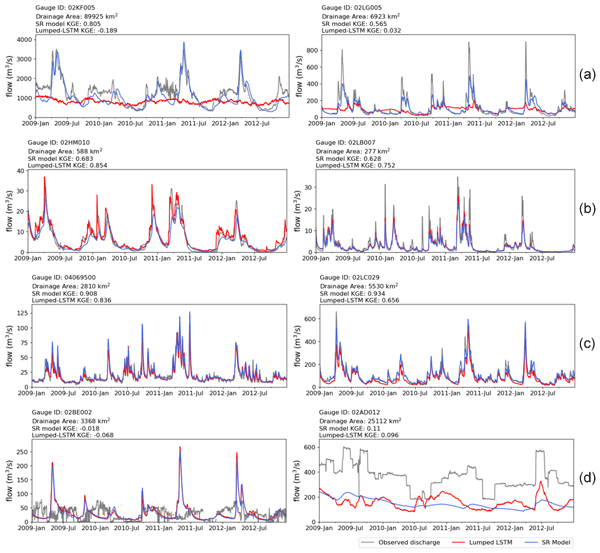
It is challenging to incorporate input variables' spatial distribution information when implementing long short-term memory (LSTM) models for streamflow prediction. This work presents a novel hybrid modelling approach to predict streamflow while accounting for spatial variability. We evaluated the performance against lumped LSTM predictions in 224 basins across the Great Lakes region in North America. This approach shows promise for predicting streamflow in large, ungauged basin.
Juliane Mai, Hongren Shen, Bryan A. Tolson, Étienne Gaborit, Richard Arsenault, James R. Craig, Vincent Fortin, Lauren M. Fry, Martin Gauch, Daniel Klotz, Frederik Kratzert, Nicole O'Brien, Daniel G. Princz, Sinan Rasiya Koya, Tirthankar Roy, Frank Seglenieks, Narayan K. Shrestha, André G. T. Temgoua, Vincent Vionnet, and Jonathan W. Waddell
Hydrol. Earth Syst. Sci., 26, 3537–3572, https://doi.org/10.5194/hess-26-3537-2022, https://doi.org/10.5194/hess-26-3537-2022, 2022
Short summary
Short summary
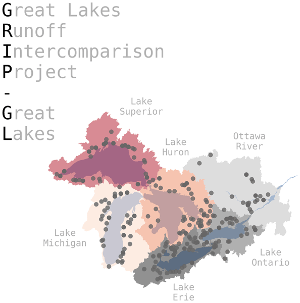
Model intercomparison studies are carried out to test various models and compare the quality of their outputs over the same domain. In this study, 13 diverse model setups using the same input data are evaluated over the Great Lakes region. Various model outputs – such as streamflow, evaporation, soil moisture, and amount of snow on the ground – are compared using standardized methods and metrics. The basin-wise model outputs and observations are made available through an interactive website.
Jonathan Romero-Cuellar, James R. Craig, Bryan A. Tolson, and Rezgar Arabzadeh
Nat. Hazards Earth Syst. Sci., 26, 5389–5406, https://doi.org/10.5194/nhess-26-5389-2026, https://doi.org/10.5194/nhess-26-5389-2026, 2026
Short summary
Short summary
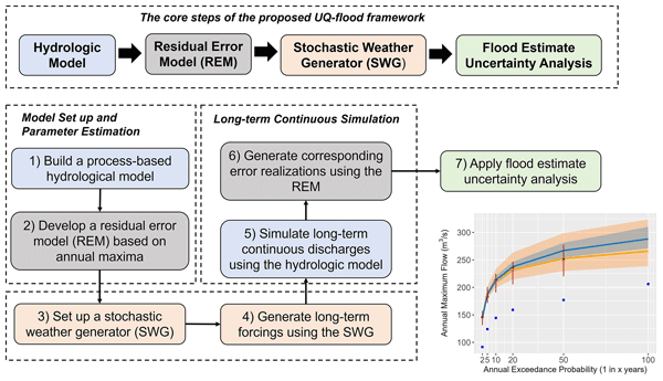
Reliable flood estimates are difficult when river records are short. We developed a method that combines recorded weather and river flow with computer simulations of many possible years, while correcting errors in predicted flood peaks. Tests in three Canadian watersheds showed that estimates based on 30 years of data agreed with benchmarks from much longer records. The method could support clearer, more informed decisions about flood protection and infrastructure where data are limited.
Aida Jabbari, Biljana Music, David Huard, James Craig, Richard Turcotte, Mohammad Bizhanimanzar, Simon Lachance-Cloutier, Charles Malenfant, and François Anctil
EGUsphere, https://doi.org/10.5194/egusphere-2026-4806, https://doi.org/10.5194/egusphere-2026-4806, 2026
This preprint is open for discussion and under review for Geoscientific Model Development (GMD).
Short summary
Short summary
Reliable streamflow predictions are important for managing water resources and preparing for floods. We developed and tested 48 versions of a hydrological model to explore how differences in model design and weather data affect predictions. We found that combining several models and accounting for uncertainty in weather data produced more reliable predictions while using fewer models. This approach can support more robust water management and flood forecasting.

Robert Chlumsky, James R. Craig, and Bryan A. Tolson
Geosci. Model Dev., 18, 3387–3403, https://doi.org/10.5194/gmd-18-3387-2025, https://doi.org/10.5194/gmd-18-3387-2025, 2025
Short summary
Short summary
We aim to improve mapping of floods and present a new method for hydraulic modelling that uses a combination of novel geospatial analysis and existing hydraulic modelling approaches. This method is wrapped into a modelling software called Blackbird. We compared Blackbird with two other existing options for flood mapping and found that the Blackbird model outperformed both. The Blackbird model has the potential to support real-time and large-scale flood mapping applications in the future.
Raoul A. Collenteur, Ezra Haaf, Mark Bakker, Tanja Liesch, Andreas Wunsch, Jenny Soonthornrangsan, Jeremy White, Nick Martin, Rui Hugman, Ed de Sousa, Didier Vanden Berghe, Xinyang Fan, Tim J. Peterson, Jānis Bikše, Antoine Di Ciacca, Xinyue Wang, Yang Zheng, Maximilian Nölscher, Julian Koch, Raphael Schneider, Nikolas Benavides Höglund, Sivarama Krishna Reddy Chidepudi, Abel Henriot, Nicolas Massei, Abderrahim Jardani, Max Gustav Rudolph, Amir Rouhani, J. Jaime Gómez-Hernández, Seifeddine Jomaa, Anna Pölz, Tim Franken, Morteza Behbooei, Jimmy Lin, and Rojin Meysami
Hydrol. Earth Syst. Sci., 28, 5193–5208, https://doi.org/10.5194/hess-28-5193-2024, https://doi.org/10.5194/hess-28-5193-2024, 2024
Short summary
Short summary
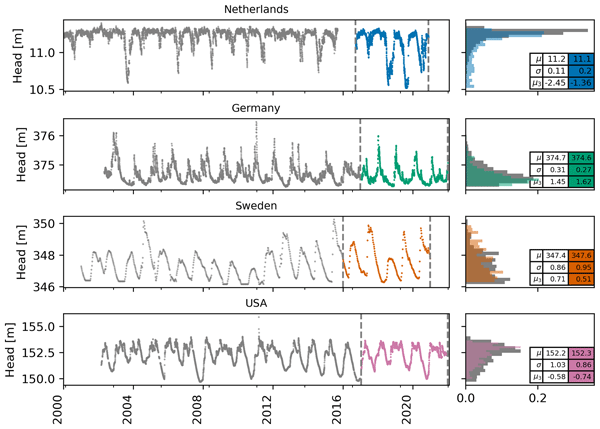
We show the results of the 2022 Groundwater Time Series Modelling Challenge; 15 teams applied data-driven models to simulate hydraulic heads, and three model groups were identified: lumped, machine learning, and deep learning. For all wells, reasonable performance was obtained by at least one team from each group. There was not one team that performed best for all wells. In conclusion, the challenge was a successful initiative to compare different models and learn from each other.
Qiutong Yu, Bryan A. Tolson, Hongren Shen, Ming Han, Juliane Mai, and Jimmy Lin
Hydrol. Earth Syst. Sci., 28, 2107–2122, https://doi.org/10.5194/hess-28-2107-2024, https://doi.org/10.5194/hess-28-2107-2024, 2024
Short summary
Short summary
It is challenging to incorporate input variables' spatial distribution information when implementing long short-term memory (LSTM) models for streamflow prediction. This work presents a novel hybrid modelling approach to predict streamflow while accounting for spatial variability. We evaluated the performance against lumped LSTM predictions in 224 basins across the Great Lakes region in North America. This approach shows promise for predicting streamflow in large, ungauged basin.
Samah Larabi, Juliane Mai, Markus Schnorbus, Bryan A. Tolson, and Francis Zwiers
Hydrol. Earth Syst. Sci., 27, 3241–3263, https://doi.org/10.5194/hess-27-3241-2023, https://doi.org/10.5194/hess-27-3241-2023, 2023
Short summary
Short summary
The computational cost of sensitivity analysis (SA) becomes prohibitive for large hydrologic modeling domains. Here, using a large-scale Variable Infiltration Capacity (VIC) deployment, we show that watershed classification helps identify the spatial pattern of parameter sensitivity within the domain at a reduced cost. Findings reveal the opportunity to leverage climate and land cover attributes to reduce the cost of SA and facilitate more rapid deployment of large-scale land surface models.
Robert Chlumsky, Juliane Mai, James R. Craig, and Bryan A. Tolson
Hydrol. Earth Syst. Sci. Discuss., https://doi.org/10.5194/hess-2023-69, https://doi.org/10.5194/hess-2023-69, 2023
Revised manuscript not accepted
Short summary
Short summary
A blended model allows multiple hydrologic processes to be represented in a single model, which allows for a model to achieve high performance without the need to modify its structure for different catchments. Here, we improve upon the initial blended version by testing more than 30 blended models in twelve catchments to improve the overall model performance. We validate our proposed, updated blended model version with independent catchments, and make this version available for open use.
Robert Chlumsky, James R. Craig, Simon G. M. Lin, Sarah Grass, Leland Scantlebury, Genevieve Brown, and Rezgar Arabzadeh
Geosci. Model Dev., 15, 7017–7030, https://doi.org/10.5194/gmd-15-7017-2022, https://doi.org/10.5194/gmd-15-7017-2022, 2022
Short summary
Short summary
We introduce the open-source RavenR package, which has been built to support the use of the hydrologic modelling framework Raven. The R package contains many functions that may be useful in each step of the model-building process, including preparing model input files, running the model, and analyzing the outputs. We present six reproducible use cases of the RavenR package for the Liard River basin in Canada to demonstrate how it may be deployed.
Juliane Mai, Hongren Shen, Bryan A. Tolson, Étienne Gaborit, Richard Arsenault, James R. Craig, Vincent Fortin, Lauren M. Fry, Martin Gauch, Daniel Klotz, Frederik Kratzert, Nicole O'Brien, Daniel G. Princz, Sinan Rasiya Koya, Tirthankar Roy, Frank Seglenieks, Narayan K. Shrestha, André G. T. Temgoua, Vincent Vionnet, and Jonathan W. Waddell
Hydrol. Earth Syst. Sci., 26, 3537–3572, https://doi.org/10.5194/hess-26-3537-2022, https://doi.org/10.5194/hess-26-3537-2022, 2022
Short summary
Short summary
Model intercomparison studies are carried out to test various models and compare the quality of their outputs over the same domain. In this study, 13 diverse model setups using the same input data are evaluated over the Great Lakes region. Various model outputs – such as streamflow, evaporation, soil moisture, and amount of snow on the ground – are compared using standardized methods and metrics. The basin-wise model outputs and observations are made available through an interactive website.
Cited articles
Arsenault, R., Brissette, F., Martel, J.-L., Troin, M., Lévesque, G., Davidson-Chaput, J., Gonzalez, M. C., Ameli, A., and Poulin, A.: A comprehensive, multisource database for hydrometeorological modeling of 14,425 North American watersheds, Sci. Data, 7, 243, https://doi.org/10.1038/s41597-020-00583-2, 2020.
Bejarano, M. D., Jansson, R., and Nilsson, C.: The effects of hydropeaking on riverine plants: a review, Biol. Rev., 93, 658–673, https://doi.org/10.1111/brv.12362, 2018.
Bipa, N. J., Stradiotti, G., Righetti, M., and Pisaturo, G. R.: Impacts of hydropeaking: A systematic review, Sci. Total Environ., 912, 169251, https://doi.org/10.1016/j.scitotenv.2023.169251, 2024.
Blöschl, G., Sivapalan, M., Wagener, T., Viglione, A., and Savenije, H. H. G. (Eds.): Runoff Prediction in Ungauged Basins: Synthesis Across Processes, Places and Scales, Cambridge University Press, https://doi.org/10.1017/CBO9781139235761, 2013.
Brimley, B., Cantin, J. F., Harvey, D., Kowalchuk, M., Marsh, P., Ouarda, T. B. M. J., Phinney, B., Pilon, P., Renouf, M., Tassone, B., Wedel, R., and Yuzyk, T.: Establishment of the reference hydrometric basin network (RHBN) for Canada, Environment Canada, Ottawa, Catalogue No. En4-701/1999E-PDF, 41 pp., https://publications.gc.ca/pub?id=9.936545&sl=0 (last access: 25 October 2026), 1999.
Brogan, C., Burgholzer, R., Keys, T., Kleiner, J., Shortridge, J., and Scott, D.: The Cumulative Role of Impoundments in Streamflow Alteration, JAWRA J. Am. Water Resour. As., 58, 119–133, https://doi.org/10.1111/1752-1688.12979, 2022.
Burke, M., Jorde, K., and Buffington, J. M.: Application of a hierarchical framework for assessing environmental impacts of dam operation: Changes in streamflow, bed mobility and recruitment of riparian trees in a western North American river, J. Environ. Manage., 90, S224–S236, https://doi.org/10.1016/j.jenvman.2008.07.022, 2009.
Cipollini, S., Fiori, A., and Volpi, E.: A New Physically Based Index to Quantify the Impact of Multiple Reservoirs on Flood Frequency at the Catchment Scale Based on the Concept of Equivalent Reservoir, Water Resour. Res., 58, e2021WR031470, https://doi.org/10.1029/2021WR031470, 2022.
Cipollini, S., Volpi, E., and Fiori, A.: Toward a Catchment-Scale Assessment of Flood Peak Attenuation by Multiple Reservoirs, Water Resour. Res., 59, e2022WR032821, https://doi.org/10.1029/2022WR032821, 2023.
Craig, J. R., Brown, G., Chlumsky, R., Jenkinson, R. W., Jost, G., Lee, K., Mai, J., Serrer, M., Sgro, N., Shafii, M., Snowdon, A. P., and Tolson, B. A.: Flexible watershed simulation with the Raven hydrological modelling framework, Environ. Model. Softw., 129, 104728, https://doi.org/10.1016/j.envsoft.2020.104728, 2020.
Dang, T. D., Chowdhury, A. F. M. K., and Galelli, S.: On the representation of water reservoir storage and operations in large-scale hydrological models: implications on model parameterization and climate change impact assessments, Hydrol. Earth Syst. Sci., 24, 397–416, https://doi.org/10.5194/hess-24-397-2020, 2020.
de Rham, L., Dibike, Y., Beltaos, S., Peters, D., Bonsal, B., and Prowse, T.: A Canadian River Ice Database from the National Hydrometric Program Archives, Earth Syst. Sci. Data, 12, 1835–1860, https://doi.org/10.5194/essd-12-1835-2020, 2020.
Déry, S. J., Stadnyk, T. A., MacDonald, M. K., and Gauli-Sharma, B.: Recent trends and variability in river discharge across northern Canada, Hydrol. Earth Syst. Sci., 20, 4801–4818, https://doi.org/10.5194/hess-20-4801-2016, 2016.
Döll, P., Fiedler, K., and Zhang, J.: Global-scale analysis of river flow alterations due to water withdrawals and reservoirs, Hydrol. Earth Syst. Sci., 13, 2413–2432, https://doi.org/10.5194/hess-13-2413-2009, 2009.
Du, T. L. T., Lee, H., Bui, D. D., Graham, L. P., Darby, S. D., Pechlivanidis, I. G., Leyland, J., Biswas, N. K., Choi, G., Batelaan, O., Bui, T. T. P., Do, S. K., Tran, T. V., Nguyen, H. T., and Hwang, E.: Streamflow Prediction in Highly Regulated, Transboundary Watersheds Using Multi-Basin Modeling and Remote Sensing Imagery, Water Resour. Res., 58, e2021WR031191, https://doi.org/10.1029/2021WR031191, 2022.
Erikson, C. M., Renshaw, C. E., and Magilligan, F. J.: Spatial variation in drainage area – Runoff relationships and implications for bankfull geometry scaling, Geomorphology, 446, 108998, https://doi.org/10.1016/j.geomorph.2023.108998, 2024.
Esri: World Topographic Map/World Imagery Basemap, Esri, https://www.arcgis.com/home/item.html?id=30e5fe3149c34df1ba922e6f5bbf808f and https://www.arcgis.com/home/item.html?id=10df2279f9684e4a9f6a7f08febac2a9 (last access: 25 October 2026), 2024.
Fry, L. M., Hunter, T. S., Phanikumar, M. S., Fortin, V., and Gronewold, A. D.: Identifying streamgage networks for maximizing the effectiveness of regional water balance modeling, Water Resour. Res., 49, 2689–2700, https://doi.org/10.1002/wrcr.20233, 2013.
Google: Google Maps base layer, Google, https://www.google.com/maps (last access: 25 October 2026), 2024.
Grill, G., Ouellet Dallaire, C., Fluet Chouinard, E., Sindorf, N., and Lehner, B.: Development of new indicators to evaluate river fragmentation and flow regulation at large scales: A case study for the Mekong River Basin, Ecol. Indic., 45, 148–159, https://doi.org/10.1016/j.ecolind.2014.03.026, 2014.
Grill, G., Lehner, B., Thieme, M., Geenen, B., Tickner, D., Antonelli, F., Babu, S., Borrelli, P., Cheng, L., Crochetiere, H., Ehalt Macedo, H., Filgueiras, R., Goichot, M., Higgins, J., Hogan, Z., Lip, B., McClain, M. E., Meng, J., Mulligan, M., Nilsson, C., Olden, J. D., Opperman, J. J., Petry, P., Reidy Liermann, C., Sáenz, L., Salinas-Rodríguez, S., Schelle, P., Schmitt, R. J. P., Snider, J., Tan, F., Tockner, K., Valdujo, P. H., van Soesbergen, A., and Zarfl, C.: Mapping the world's free-flowing rivers, Nature, 569, 215–221, https://doi.org/10.1038/s41586-019-1111-9, 2019.
Habets, F., Molénat, J., Carluer, N., Douez, O., and Leenhardt, D.: The cumulative impacts of small reservoirs on hydrology: A review, Sci. Total Environ., 643, 850–867, https://doi.org/10.1016/j.scitotenv.2018.06.188, 2018.
Han, M., Shen, H., Tolson, B. A., Craig, J. R., Mai, J., Lin, S. G. M., Basu, N. B., and Awol, F. S.: BasinMaker 3.0: A GIS toolbox for distributed watershed delineation of complex lake-river routing networks, Environ. Model. Softw., 164, 105688, https://doi.org/10.1016/j.envsoft.2023.105688, 2023.
Hrachowitz, M., Savenije, H. H. G., Blöschl, G., McDonnell, J. J., Sivapalan, M., Pomeroy, J. W., Arheimer, B., Blume, T., Clark, M. P., Ehret, U., Fenicia, F., Freer, J. E., Gelfan, A., Gupta, H. V., Hughes, D. A., Hut, R. W., Montanari, A., Pande, S., Tetzlaff, D., Troch, P. A., Uhlenbrook, S., Wagener, T., Winsemius, H. C., Woods, R. A., Zehe, E., and Cudennec, C.: A decade of Predictions in Ungauged Basins (PUB) – a review, Hydrolog. Sci. J., 58, 1198–1255, https://doi.org/10.1080/02626667.2013.803183, 2013.
Hudson, D. T., Leach, J. A., Webster, K., and Houle, D.: Streamflow regime of a lake-stream system based on long-term data from a high-density hydrometric network, Hydrol. Process., 35, e14396, https://doi.org/10.1002/hyp.14396, 2021.
Hughes, D., Birkinshaw, S., and Parkin, G.: A method to include reservoir operations in catchment hydrological models using SHETRAN, Environ. Model. Softw., 138, 104980, https://doi.org/10.1016/j.envsoft.2021.104980, 2021.
International Joint Commission: An Overview of Great Lakes Diversions, International Joint Commission, https://ijc.org/en/lsbc/watershed/great-lakes-diversions (last access: 25 October 2026), 2020.
Jorde, K., Burke, M., Scheidt, N., Welcker, C., King, S., and Borden, C.: 23 Reservoir operations, physical processes, and ecosystem losses, in: Gravel-Bed Rivers VI: From Process Understanding to River Restoration, Developments in Earth Surface Processes, Vol. 11, edited by: Habersack, H., Piégay, H., and Rinaldi, M., Elsevier, 607–636, https://doi.org/10.1016/S0928-2025(07)11151-2, 2007.
Kern, J. D., Characklis, G. W., Doyle, M. W., Blumsack, S., and Whisnant, R. B.: Influence of deregulated electricity markets on hydropower generation and downstream flow regime, J. Water Res. Pl., 138, 342–355, https://doi.org/10.1061/(ASCE)WR.1943-5452.0000183, 2012.
Kratzert, F., Klotz, D., Herrnegger, M., Sampson, A. K., Hochreiter, S., and Nearing, G. S.: Toward Improved Predictions in Ungauged Basins: Exploiting the Power of Machine Learning, Water Resour. Res., 55, 11344–11354, https://doi.org/10.1029/2019WR026065, 2019a.
Kratzert, F., Klotz, D., Shalev, G., Klambauer, G., Hochreiter, S., and Nearing, G.: Towards learning universal, regional, and local hydrological behaviors via machine learning applied to large-sample datasets, Hydrol. Earth Syst. Sci., 23, 5089–5110, https://doi.org/10.5194/hess-23-5089-2019, 2019b.
Kumar, H., Hwang, J., Devineni, N., and Sankarasubramanian, A.: Dynamic Flow Alteration Index for Complex River Networks With Cascading Reservoir Systems, Water Resour. Res., 58, e2021WR030491, https://doi.org/10.1029/2021WR030491, 2022.
Lehner, B., Liermann, C. R., Revenga, C., Vörösmarty, C., Fekete, B., Crouzet, P., Döll, P., Endejan, M., Frenken, K., Magome, J., Nilsson, C., Robertson, J. C., Rödel, R., Sindorf, N., and Wisser, D.: High-resolution mapping of the world's reservoirs and dams for sustainable river-flow management, Front. Ecol. Environ., 9, 494–502, https://doi.org/10.1890/100125, 2011.
Lehner, B., Beames, P., Mulligan, M., Zarfl, C., De Felice, L., van Soesbergen, A., Thieme, M., Garcia de Leaniz, C., Anand, M., Belletti, B., Brauman, K. A., Januchowski-Hartley, S. R., Lyon, K., Mandle, L., Mazany-Wright, N., Messager, M. L., Pavelsky, T., Pekel, J.-F., Wang, J., Wen, Q., Wishart, M., Xing, T., Yang, X., and Higgins, J.: The Global Dam Watch database of river barrier and reservoir information for large-scale applications, Sci. Data, 11, 1069, https://doi.org/10.1038/s41597-024-03752-9, 2024.
Lewis, A., Hatfield, T., Chilibeck, B., and Roberts, C.: Assessment Methods for Aquatic Habitat and Instream Flow Characteristics in Support of Applications to Dam, Divert, or Extract Water from Streams in British Columbia, Final Version, British Columbia Ministry of Water, Land and Air Protection and Ministry of Sustainable Resource Management, https://www.env.gov.bc.ca/wld/documents/bmp/assessment_methods_instreamflow_in_bc.pdf (last access: 25 October 2026), 2004.
Lueders, M. B., McManamay, R. A., Oliver, J. A., Young, D., Bean, P., and Mayes, K.: Reconstructing Long-Term Historical Hydrologic Alteration to Support Environmental Flows in Texas, River Res. Appl., 1–17, https://doi.org/10.1002/rra.70172, 2026.
Maavara, T., Chen, Q., Van Meter, K., Brown, L. E., Zhang, J., Ni, J., and Zarfl, C.: River dam impacts on biogeochemical cycling, Nat. Rev. Earth Environ., 1, 103–116, https://doi.org/10.1038/s43017-019-0019-0, 2020.
Messager, M. L., Lehner, B., Grill, G., Nedeva, I., and Schmitt, O.: Estimating the volume and age of water stored in global lakes using a geo-statistical approach, Nat. Commun., 7, 13603, https://doi.org/10.1038/ncomms13603, 2016.
Metcalfe, R. A., Mackereth, R. W., Grantham, B., Jones, N., Pyrce, R. S., Haxton, T., Luce, J. J., and Stainton, R.: Aquatic Ecosystem Assessments for Rivers, Aquatic Research Series 2013-06, Science and Research Branch, Ministry of Natural Resources, Peterborough, Ontario, ISBN 978-1-4606-3215-4 (PDF), 2013.
Ministry of Natural Resources and Forestry: Maintaining Water Management Plans: Technical Bulletin, Ministry of Natural Resources and Forestry, https://files.ontario.ca/technical-bulletin-maintaining-wmps.pdf (last access: 25 October 2026), 2016.
Montanari, A., Young, G., Savenije, H. H. G., Hughes, D., Wagener, T., Ren, L. L., Koutsoyiannis, D., Cudennec, C., Toth, E., Grimaldi, S., Blöschl, G., Sivapalan, M., Beven, K., Gupta, H., Hipsey, M., Schaefli, B., Arheimer, B., Boegh, E., Schymanski, S. J., Di Baldassarre, G., Yu, B., Hubert, P., Huang, Y., Schumann, A., Post, D. A., Srinivasan, V., Harman, C., Thompson, S., Rogger, M., Viglione, A., McMillan, H., Characklis, G., Pang, Z., and Belyaev, V.: “Panta Rhei – Everything Flows”: Change in hydrology and society – The IAHS Scientific Decade 2013–2022, Hydrolog. Sci. J., 58, 1256–1275, https://doi.org/10.1080/02626667.2013.809088, 2013.
Nilsson, C., Reidy, C. A., Dynesius, M., and Revenga, C.: Fragmentation and flow regulation of the world's large river systems, Science, 308, 405–408, https://doi.org/10.1126/science.1107887, 2005.
Ontario Ministry of Natural Resources: Ontario Dam Inventory, Ontario Ministry of Natural Resources [data set], https://geohub.lio.gov.on.ca/maps/mnrf::ontario-dam-inventory/about (last access: 25 October 2026), 2014.
Ontario Ministry of Natural Resources and Forestry: Lakes and Rivers Improvement Act Administrative Guide, Ontario Ministry of Natural Resources and Forestry, https://www.ontario.ca/page/lakes-and-rivers-improvement-act-administrative-guide (last access: 25 October 2026), 2017.
Ouarda, T., Rasmussen, P., Cantin, J., Bobée, B., Laurence, R., and Hoang, V.: Identification d'un réseau hydrométrique pour le suivi des modifications climatiques dans la province de Québec, Rev. Sci. Eau J. Water Sci., 12, 425–448, https://doi.org/10.7202/705359ar, 1999.
Palmer, M. and Ruhi, A.: Linkages between flow regime, biota, and ecosystem processes: Implications for river restoration, Science, 365, eaaw2087, https://doi.org/10.1126/science.aaw2087, 2019.
Pellerin, J.: Updating the Canadian Reference Hydrometric Basin Network to detect climate-related trends in streamflow, Master's Thesis, University of Waterloo, https://hdl.handle.net/10012/14574 (last access: 25 October 2026), 2019.
Petts, G. E.: The Adjustment of River channel Capacity Downstream from Reservoirs in Great Britain, PhD thesis, University of Southampton, https://eprints.soton.ac.uk/458889/ (last access: 25 October 2026), 1978.
Petts, G. E.: Complex response of river channel morphology subsequent to reservoir construction, Prog. Phys. Geogr., 3, 329–362, https://doi.org/10.1177/030913337900300302, 1979.
Petts, G. E.: Long-term consequences of upstream impoundment, Environ. Conserv., 7, 325–332, https://doi.org/10.1017/S0376892900008183, 1980.
Petts, G. E.: Impounded rivers: perspectives for ecological management, Wiley, ISBN 9780471103066, 1984.
Poff, N. L., Allan, J. D., Bain, M. B., Karr, J. R., Prestegaard, K. L., Richter, B. D., Sparks, R. E., and Stromberg, J. C.: The natural flow regime, BioScience, 47, 769–784, https://doi.org/10.2307/1313099, 1997.
Poff, N. L., Richter, B. D., Arthington, A. H., Bunn, S. E., Naiman, R. J., Kendy, E., Acreman, M., Apse, C., Bledsoe, B. P., Freeman, M. C., Henriksen, J., Jacobson, R. B., Kennen, J. G., Merritt, D. M., O'Keeffe, J. H., Olden, J. D., Rogers, K., Tharme, R. E., and Warner, A.: The ecological limits of hydrologic alteration (ELOHA): a new framework for developing regional environmental flow standards, Freshwater Biol., 55, 147–170, https://doi.org/10.1111/j.1365-2427.2009.02204.x, 2010.
Richter, B. D., Postel, S., Revenga, C., Scudder, T., Lehner, B., Churchill, A., and Chow, M.: Lost in development's shadow: The downstream human consequences of dams, Water Altern., 3, 14–42, 2010.
Salwey, S., Coxon, G., Pianosi, F., Lane, R., Hutton, C., Bliss Singer, M., McMillan, H., and Freer, J.: Developing water supply reservoir operating rules for large-scale hydrological modelling, Hydrol. Earth Syst. Sci., 28, 4203–4218, https://doi.org/10.5194/hess-28-4203-2024, 2024.
Schmadel, N. M., Harvey, J. W., Alexander, R. B., Schwarz, G. E., Moore, R. B., Eng, K., Gomez-Velez, J. D., Boyer, E. W., and Scott, D.: Thresholds of lake and reservoir connectivity in river networks control nitrogen removal, Nat. Commun., 9, 2779, https://doi.org/10.1038/s41467-018-05156-x, 2018.
Schmadel, N. M., Harvey, J. W., Schwarz, G. E., Alexander, R. B., Gomez-Velez, J. D., Scott, D., and Ator, S. W.: Small Ponds in Headwater Catchments Are a Dominant Influence on Regional Nutrient and Sediment Budgets, Geophys. Res. Lett., 46, 9669–9677, https://doi.org/10.1029/2019GL083937, 2019.
SEI International: Strategic Environmental Assessment of the Hydropower Master Plan in the Context of the Power Development Plan VI: Final Report, Stockholm Environment Institute, https://mediamanager.sei.org/documents/Publications/SEI-SEA-Hydropower-Vietname-FullReport-2009.pdf (last access: 25 October 2026), 2009.
Shen, H.: Streamflow Alteration Index (SAI) calculation tools (v1.0.0), Zenodo [code], https://doi.org/10.5281/zenodo.23602080, 2026.
Shen, H., Han, M., Tolson, B., and Metcalfe, R. A.: The Ontario Lake and River Routing Product Version 2 (OLRRP V2), Zenodo [data set], https://doi.org/10.5281/zenodo.14225103, 2024.
Shen, H., Tolson, B., Craig, J., Metcalfe, R. A., Romero-Cuellar, J., and Luce, J.: Streamflow Alteration Index (SAI) v1.0 Database for Ontario, Canada, Zenodo [data set], https://doi.org/10.5281/zenodo.19547932, 2026.
Shrestha, P. K., Samaniego, L., Rakovec, O., Kumar, R., Mi, C., Rinke, K., and Thober, S.: Toward Improved Simulations of Disruptive Reservoirs in Global Hydrological Modeling, Water Resour. Res., 60, e2023WR035433, https://doi.org/10.1029/2023WR035433, 2024.
Smokorowski, K. E.: The ups and downs of hydropeaking: a Canadian perspective on the need for, and ecological costs of, peaking hydropower production, Hydrobiologia, 849, 421–441, https://doi.org/10.1007/s10750-020-04480-y, 2022.
Stainton, R. T.: Hydrologic Zone of Influence Downstream of Waterpower Facilities: Literature Review and Analysis of Potential Methods to Support Prediction in Ontario Rivers, IWS Report No. 02-2012, Institute for Watershed Science, Trent University, Peterborough, Ontario, Canada, 2012.
Steyaert, J. C., Sutanudjaja, E. H., Bierkens, M., and Wanders, N.: Data derived reservoir operations simulated in a global hydrologic model, Hydrol. Earth Syst. Sci., 29, 6499–6527, https://doi.org/10.5194/hess-29-6499-2025, 2025.
Tharme, R. E.: A global perspective on environmental flow assessment: emerging trends in the development and application of environmental flow methodologies for rivers, River Res. Appl., 19, 397–441, https://doi.org/10.1002/rra.736, 2003.
Tursun, A., Xie, X., Wang, Y., Peng, D., Liu, Y., Zheng, B., Wu, X., and Nie, C.: Streamflow Prediction in Human-Regulated Catchments Using Multiscale Deep Learning Modeling With Anthropogenic Similarities, Water Resour. Res., 60, e2023WR036853, https://doi.org/10.1029/2023WR036853, 2024.
Wada, Y., Bierkens, M. F. P., de Roo, A., Dirmeyer, P. A., Famiglietti, J. S., Hanasaki, N., Konar, M., Liu, J., Müller Schmied, H., Oki, T., Pokhrel, Y., Sivapalan, M., Troy, T. J., van Dijk, A. I. J. M., van Emmerik, T., Van Huijgevoort, M. H. J., Van Lanen, H. A. J., Vörösmarty, C. J., Wanders, N., and Wheater, H.: Human–water interface in hydrological modelling: current status and future directions, Hydrol. Earth Syst. Sci., 21, 4169–4193, https://doi.org/10.5194/hess-21-4169-2017, 2017.
Wang, J., Walter, B. A., Yao, F., Song, C., Ding, M., Maroof, A. S., Zhu, J., Fan, C., McAlister, J. M., Sikder, S., Sheng, Y., Allen, G. H., Crétaux, J.-F., and Wada, Y.: GeoDAR: georeferenced global dams and reservoirs dataset for bridging attributes and geolocations, Earth Syst. Sci. Data, 14, 1869–1899, https://doi.org/10.5194/essd-14-1869-2022, 2022.
Water Survey of Canada: National Water Data Archive (HYDAT), 14 October 2025 release, Water Survey of Canada [data set], https://www.canada.ca/en/environment-climate-change/services/water-overview/quantity/monitoring/survey/data-products-services/national-archive-hydat.html (last access: 25 October 2026), 2025.
WCD: Dams and Development: A New Framework for Decision-making: the Report of the World Commission on Dams, Earthscan, ISBN 9781853837982, 2000.
Wieczorek, M. E., Wolock, D. M., and McCarthy, P. M.: Dam impact/disturbance metrics for the conterminous United States, 1800 to 2018, U.S. Geological Survey [data set], https://doi.org/10.5066/P92S9ZX6, 2021.
Winemiller, K. O., McIntyre, P. B., Castello, L., Fluet-Chouinard, E., Giarrizzo, T., Nam, S., Baird, I. G., Darwall, W., Lujan, N. K., Harrison, I., Stiassny, M. L. J., Silvano, R. A. M., Fitzgerald, D. B., Pelicice, F. M., Agostinho, A. A., Gomes, L. C., Albert, J. S., Baran, E., Petrere, M., Zarfl, C., Mulligan, M., Sullivan, J. P., Arantes, C. C., Sousa, L. M., Koning, A. A., Hoeinghaus, D. J., Sabaj, M., Lundberg, J. G., Armbruster, J., Thieme, M. L., Petry, P., Zuanon, J., Vilara, G. T., Snoeks, J., Ou, C., Rainboth, W., Pavanelli, C. S., Akama, A., Soesbergen, A. V., and Sáenz, L.: Balancing hydropower and biodiversity in the Amazon, Congo, and Mekong, Science, 351, 128–129, https://doi.org/10.1126/science.aac7082, 2016.
Yang, X., Pavelsky, T. M., Ross, M. R. V., Januchowski-Hartley, S. R., Dolan, W., Altenau, E. H., Belanger, M., Byron, D., Durand, M., Van Dusen, I., Galit, H., Jorissen, M., Langhorst, T., Lawton, E., Lynch, R., Mcquillan, K. A., Pawar, S., and Whittemore, A.: Mapping Flow-Obstructing Structures on Global Rivers, Water Resour. Res., 58, e2021WR030386, https://doi.org/10.1029/2021WR030386, 2022.
Yassin, F., Razavi, S., Elshamy, M., Davison, B., Sapriza-Azuri, G., and Wheater, H.: Representation and improved parameterization of reservoir operation in hydrological and land-surface models, Hydrol. Earth Syst. Sci., 23, 3735–3764, https://doi.org/10.5194/hess-23-3735-2019, 2019.
Yin, Z., Lin, P., Riggs, R., Allen, G. H., Lei, X., Zheng, Z., and Cai, S.: A synthesis of Global Streamflow Characteristics, Hydrometeorology, and Catchment Attributes (GSHA) for large sample river-centric studies, Earth Syst. Sci. Data, 16, 1559–1587, https://doi.org/10.5194/essd-16-1559-2024, 2024.
Yue, S. and Gan, T. Y.: Simple scaling properties of Canadian annual average streamflow, Adv. Water Resour., 27, 481–495, https://doi.org/10.1016/j.advwatres.2004.02.019, 2004.
Zajac, Z., Revilla-Romero, B., Salamon, P., Burek, P., Hirpa, F. A., and Beck, H.: The impact of lake and reservoir parameterization on global streamflow simulation, J. Hydrol., 548, 552–568, https://doi.org/10.1016/j.jhydrol.2017.03.022, 2017.
Short summary
Dams and other water-control structures can influence rivers far downstream. We calculated the Streamflow Alteration Index for 245 576 subbasins across Ontario, Canada, averaging 4.3 square kilometres. By linking structure locations with connected lake and river networks, we mapped potential downstream influence, including places without flow measurements. This province-wide dataset supports river modelling, water management, ecological studies and targeted local assessments.
Dams and other water-control structures can influence rivers far downstream. We calculated the...


Altmetrics
Final-revised paper
Preprint