the Creative Commons Attribution 4.0 License.
the Creative Commons Attribution 4.0 License.
 | 29 Apr 2026
Creation and analysis of a multi-hazard dataset: Tenerife (Canary Islands) as a case study
Marta López-Saavedra
Joan Martí
Marc Martínez-Sepúlveda
In the context of escalating climate change impacts and the heightened frequency of natural hazards, the imperative for robust multi-risk assessment and proactive mitigation strategies has become increasingly evident. Tenerife, situated in the Atlantic archipelago, encapsulates the challenges faced by communities globally, prompting a paradigm shift towards anticipatory risk management. This study presents a pioneering effort to establish a multi-hazard dataset for regions susceptible to be impacted by multiple natural hazards, using Tenerife (Canary Islands) as a case study, to provide a foundation for more accurate risk assessments and informed decision-making. Our methodology involved the systematic collection and analysis of over 500 years of historical data (https://doi.org/10.20350/digitalCSIC/17088, López-Saavedra et al., 2025) on volcanic activity, earthquakes, floods, landslides, and extreme weather events, allowing us to identify patterns, impacts, and effective resilience measures. In this sense, our holistic approach aims to empower stakeholders with a nuanced understanding of natural processes. The dataset reveals key patterns in hazard occurrence and impacts, such as the frequent and damaging floods linked to heavy rainfall and ravine overflows. It also highlights the increasing frequency and severity of these events in recent decades, underscoring the urgent need for improved management practices. Other hazards, like rock falls and landslides, though less common, pose significant risks in areas affected by human activities. Key recommendations include the implementation of flood prevention measures such as ravine cleaning, water retention areas, and reforestation, as well as enhanced geotechnical studies and slope stabilization efforts to mitigate landslide risks. The approach outlined here is not only applicable to Tenerife but serves as a scalable model for other regions facing complex natural hazard scenarios. By leveraging historical insights alongside contemporary methodologies, this contribution aims to strengthen natural risk resilience and inform future risk mitigation strategies.
- Article
(5515 KB) - Full-text XML
-
Supplement
(398 KB) - BibTeX
- EndNote


In the face of escalating climate change impacts and the increasing frequency and intensity of natural hazards, the need for robust multi-hazard risk assessment and mitigation strategies has never been more critical. Fortunately, contemporary discourse on risk management has evolved beyond a reactive stance, prompting a paradigm shift toward proactive and anticipatory approaches (e.g., UNISDR, 2015; UNDRR, 2022). Many regions worldwide have a complex history of exposure to various natural hazards, including volcanic activity, seismic events, and meteorological phenomena (e.g., López-Saavedra and Martí, 2023; Lee et al., 2024). Understanding the dynamic interplay of these hazards is fundamental to forecasting and mitigating their future manifestations (e.g., Ming et al., 2022; Ward et al., 2022; López-Saavedra and Martí, 2023).
Traditionally, quantitative risk assessments have relied on physics-based predictive models. However, data-driven predictive models are increasingly being integrated into risk assessments (Stødle et al., 2023). Data-driven modeling is instrumental in approximating the relationships between explanatory and response variables (Stødle et al., 2023). This empirical approach not only enables the identification of complex patterns but also provides a framework for addressing uncertainties – an essential component of multi-hazard assessments, given the intricate and often unexpected interrelationships among natural phenomena (López-Saavedra and Martí, 2023). Today, the continuous collection of vast amounts of operational data through advanced sensing and monitoring systems allows for more sophisticated, data-driven risk assessment approaches (Guikema, 2020). These methodologies, which include statistical and machine learning models, leverage extensive datasets to forecast future outcomes and evaluate potential risks, thereby surpassing the limitations imposed by historical data alone (Stødle et al., 2023).
Despite the advancements facilitated by data-driven methods, a significant challenge remains: the availability and comprehensiveness of historical and real-time data on natural phenomena in specific regions. Many areas face limitations in both the instrumentation used to monitor these phenomena and the relatively recent initiation of data collection efforts (UNDRR and WMO, 2023), which restricts the availability of long-term datasets necessary for robust risk assessment and management. In numerous regions, existing datasets are insufficiently comprehensive to establish baseline conditions or accurately define “background” levels of natural hazards. This lack of historical data undermines the ability to set effective warning thresholds and develop comprehensive risk management protocols. For instance, without a detailed historical record, identifying patterns or establishing reliable baselines for event frequency and intensity becomes challenging, thereby hindering the development of accurate quantitative risk models and effective hazard preparedness strategies (Stødle et al., 2023).
Addressing these data gaps necessitates the development of a comprehensive historical record of all significant events that have occurred in each region. The significance of such a dataset extends beyond data collection, as it provides a critical resource for developing and validating predictive models applicable across different scenarios and timeframes. For example, probabilistic risk models, which simulate a range of possible future events based on historical data and expert knowledge, depend on the quality and completeness of the available data (UNDRR, 2012). Additionally, probabilistic modelling can be employed to generate deterministic scenarios by using real data as input values, which are then subjected to climate change predictive models to assess hazard impacts. A well-documented multi-hazard database, integrating robust exposure, vulnerability (physical, social, economic) and resilience data, supports the generation of robust probabilistic risk assessments and enhances the capacity to manage uncertainties associated with future risk scenarios (UNDRR, 2012). Such a record serves as a foundation for understanding the full spectrum of potential hazards which, combined with impact studies, and vulnerability and exposure, data, enables the quantification and measurement of their impacts, thereby enabling more informed and proactive risk management strategies (Guikema, 2020). Furthermore, a comprehensive historical dataset not only facilitates the establishment of baseline conditions but also supports the development of early warning systems and response protocols by providing a detailed account of past events, which is instrumental in evaluating future risks (López-Saavedra and Martí, 2023). Therefore, establishing a thorough historical record of natural hazards is indispensable for effective multi-hazard assessments and for enhancing the resilience of communities against future events. By compiling a comprehensive dataset, regions can better identify historical patterns, develop more accurate risk models, and design more effective risk management strategies, in alignment with the principles outlined in the Sendai Framework for Disaster Risk Reduction (UNISDR, 2015).
This approach aims not only to document a region's encounters with various hazards but also to empower stakeholders with a comprehensive understanding of the underlying natural processes. This holistic strategy, integrating contemporary monitoring techniques with historical context, establishes a synergy essential for effective, long-term risk mitigation (e.g., Notti et al., 2022; Luino et al., 2023a, b; Oliva and Olcina, 2024). This contribution serves as a blueprint for developing a multi-hazard database that integrates data from diverse sources and in various formats. Tenerife has been selected as a case study due to its status as a microcosm of vulnerability within the Atlantic archipelago, exemplifying the challenges faced by communities worldwide. This approach systematically captures the historical record of natural events. The proposed methodology not only illuminates the unique challenges faced by this region but also provides a scalable model applicable to areas experiencing diverse natural phenomena. By establishing this comprehensive dataset, we aim to facilitate precise multi-hazard assessments and improve multi-risk management. Our ultimate objective is to contribute to a proactive and informed approach, enhancing natural risk resilience in Tenerife and serving as a template for regions worldwide that grapple with the complex interplay of natural hazards affecting their populations.
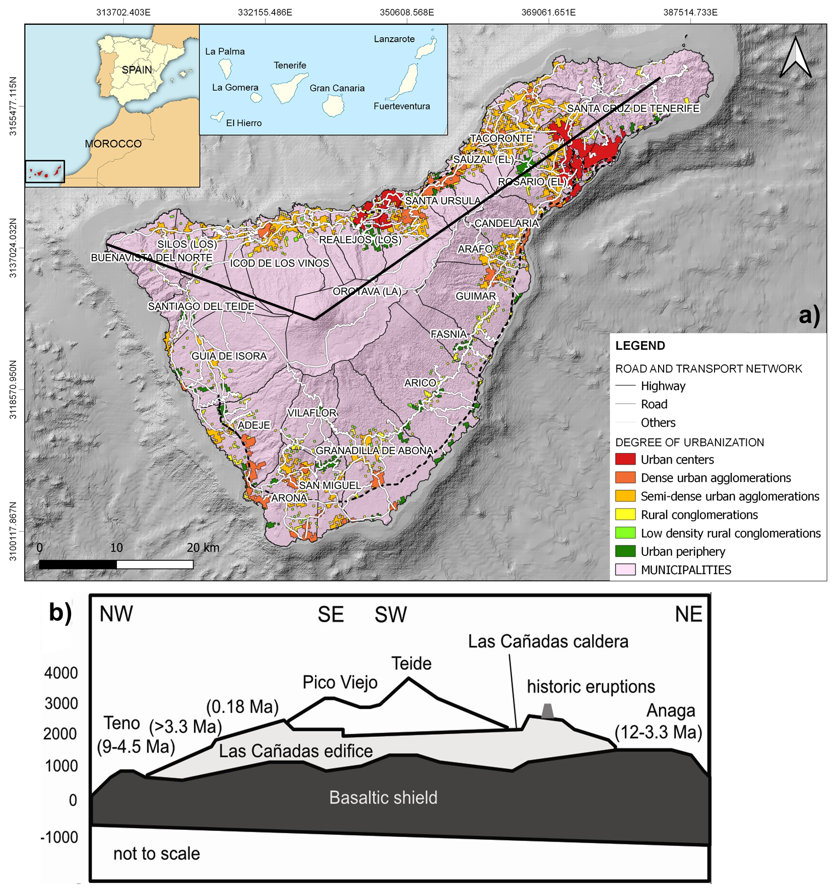
Figure 1(a) Geographical location of the Canary Islands in general, and Tenerife in particular, together with the distribution of municipalities and urban areas; (b) schematic cross-section of the island. The black lines correspond to the cross-section of part (b) of this figure. Source: adapted from López-Saavedra et al. (2021) and López-Saavedra and Martí (2023) (CC BY-NC-ND 4.0).
With a land area of 2034 km2, Tenerife is the largest of the eight volcanic islands that constitute the Canary Islands archipelago. Located in the east-central Atlantic Ocean, approximately 300 km off the southern coast of Morocco in northwest Africa (Fig. 1a), the Canary Islands lie within the African Plate. The origin of the Canarian magmatism, whether it is the result of a persistent mantle plume or active tectonics or a combination of both, is still a matter of considerable debate (Hernández-Pacheco and Ibarrola, 1973; Anguita and Hernán, 1975, 2000; Schmincke, 1982; Araña and Ortiz, 1991; Hoernle and Schmincke, 1993; Carracedo et al., 1998; Fullea et al., 2015).
Regional tectonics in this sector of the African Plate, investigated through GPS measurements, seismicity analysis, and crustal deformation studies (Jiménez-Munt et al., 2001; Jiménez-Munt and Negredo, 2003; Serpelloni et al., 2007; Jiménez-Munt et al., 2011; Cunha et al., 2012; Bezzeghoud et al., 2014), have revealed the presence of a simple extensional deformation field oriented west to east across the Canary Archipelago. This deformation, which is perpendicular to the Mid-Atlantic and Terceira Ridges, has been identified as a key mechanism facilitating the formation of pathways for magma ascent to the surface (Anguita and Hernán, 2000).
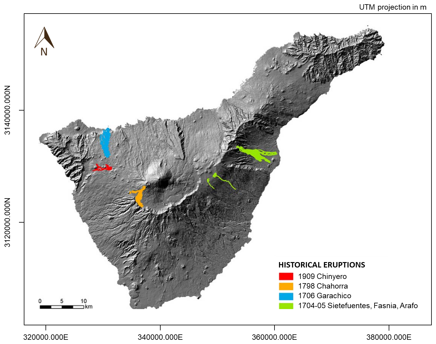
Figure 2Map of the historical eruptions of Tenerife (Canary Islands). Source: adapted from IGN (2025).
Centrally located within the archipelago, Tenerife emerges as a large, pyramid-shaped volcanic edifice, rising nearly 8000 m above the Miocene oceanic crust (Fig. 1b). The island hosts the active Teide volcano, which reaches an elevation of 3718 m above sea level, ranking Tenerife as the third-largest and one of the most complex volcanic systems globally, following Mauna Loa and Mauna Kea in Hawaii. Despite its geographical distance from the Iberian Peninsula, the Canary Islands remain part of the Spanish state due to their colonial history.
The geological evolution of Tenerife is characterized by two primary superimposed volcanic complexes: a basaltic shield complex (>12 Ma to present; Abdel-Monem et al., 1972; Ancochea et al., 1990; Thirlwall et al., 2000) and a central complex (<4 Ma to present; Fuster et al., 1968; Araña, 1971; Ancochea et al., 1990; Martí et al., 1994) (Fig. 1b). As an active volcanic island, Tenerife is subject to volcanic hazards such as lava flows, Pyroclastic Density Currents (PDCs), ashfall, explosions, earthquakes, gas emissions, etc. The construction of the island has been primarily driven by basaltic shield-building volcanism, which remains active today through eruptions along the northeastern (Dorsal Rift Zone) and northwestern (Santiago Rift Zone) fissure vent systems. Additionally, volcanic activity occurs at several small scoria-lava cones located at the heads of major landslide valleys (La Orotava, Icod, and Güímar) and within a broad monogenetic volcanic field in the southern part of the island (Martí, 2019).
Tenerife has been the site of four of the 14 historic eruptions that have occurred in the archipelago since 1500 CE: Siete Fuentes-Fasnia-Arafo (1704–1705), Garachico (1706), Chahorra (1798), and Chinyero (1909) (Fig. 2). In contrast, Teide and its twin volcano, Pico Viejo, have not erupted in historical times, with their last known eruption (Lavas Negras) occurring approximately 1000 years ago (Martí et al., 2022). However, up to 18 eruptions have been identified on the island during the Holocene (Martí et al., 2008).
Seismic activity in Tenerife is closely associated with volcanic processes, as evidenced by the high-magnitude earthquakes that occurred during the triple eruption of Siete Fuentes, Fasnia, and Arafo (1704–1705) (Sánchez-Sanz, 2014). In fact, all historical eruptions have been preceded and/or accompanied by felt earthquakes (Romero, 1991).
At present, moderate-magnitude (typically not exceeding 2.0 mbLg(L), occasionally reaching 3.0 mbLg(L)) and shallow seismicity, primarily related to magma intrusion and hydrothermal system dynamics, is concentrated along the Santiago Rift Zone, particularly around the Chahorra (1798) and Chinyero (1909) volcanoes. Similar activity is also observed along the Dorsal Rift Zone, affecting the Arafo, Fasnia, and Siete Fuentes (1704–1705) volcanoes, as well as the southern monogenetic volcanic field (IGN, 2023a, b).
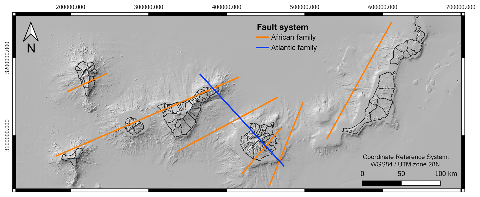
Figure 3Volcano-tectonic lines of the Canary Islands' region. Source: adapted from Bosshard and Macfarlane (1970), and Mezcua et al. (1992). * Note: Orange lines = African family of faults; blue lines = Atlantic family of faults. Fault traces are not to scale nor is the location accurate, but are indicative.
In addition to this background seismicity, Tenerife experiences episodic seismic swarms that are concentrated in four key seismogenic zones: (i) the western sector of the Caldera de Las Cañadas, where two significant swarms, comprising hundreds of low-magnitude earthquakes, occurred in 2016 and 2019; (ii) the Izaña region, which exhibited substantial seismic activity between 2009 and 2011; (iii) the area surrounding Pico del Teide, where seismicity recurs periodically; and (iv) the Vilaflor region, at the head of the southern monogenetic volcanic field, where intermittent seismic activity has persisted to the present (Domínguez Cerdeña et al., 2019).
However, the most significant earthquakes have been concentrated along the fault zone between Tenerife and Gran Canaria (Fig. 3), which has produced the strongest seismic event recorded in historical times (ML 5.3 in 1989; Mezcua et al., 1992).
On the other hand, the Canary Islands exhibit a subtropical climate, characterized by mild winters (mean temperature >20 °C), low annual precipitation (<225 mm), and abundant sunshine (2800 h yr−1) (Azorín-Molina et al., 2018; Megías and García-Román, 2022). However, due to its location, the weather variability in the Canary Islands is influenced by the interaction between the semi-permanent Azores subtropical high-pressure system, and its relation with the Icelandic Low, and the air masses coming from the Sahara (Cropper and Hanna, 2014; Cabildo de Tenerife, 2020; Megías and García-Román, 2022). For this reason, there are three main types of weather on the islands (Cabildo de Tenerife, 2020):
-
The trade winds regime, characterized by stable, warm and not very rainy weather, which originates mainly in summer, when the Azores Anticyclone withdraws towards the Portuguese coast.
-
The Atlantic squalls, which leave more unstable and rainy weather, especially in autumn and spring, originating when the Azores Anticyclone withdraws towards the center of the Atlantic and a Polar Front squall approaches.
-
Saharan weather, warmer and drier, especially in the winter months, although it can occur at any time of the year, and is caused when the Azores Anticyclone withdraws towards the center of the Atlantic and a dry air mass from the Sahara arrives. It is often accompanied by the well-known “calima” or Saharan dust in suspension.
Tenerife's climate is strongly influenced by topography and orientation (Cabildo de Tenerife, 2020; Megías and García-Román, 2022), resulting in pronounced contrasts between the windward (northern) and leeward (southern) slopes. The northern slopes, exposed to the trade winds, experience higher precipitation, greater humidity, and less sunshine, whereas the southern slopes are much drier and more arid. There are also great differences within each slope depending on the altitude (e.g., precipitation and average annual temperature, respectively, of 223 mm and 21 °C on the coast of Santa Cruz de Tenerife, 559 mm and 16.8 °C in the middle zone of Los Rodeos, and 487 mm and 10 °C on the summits of Izaña) (Cabildo de Tenerife, 2020) (Figs. 4 and 5).
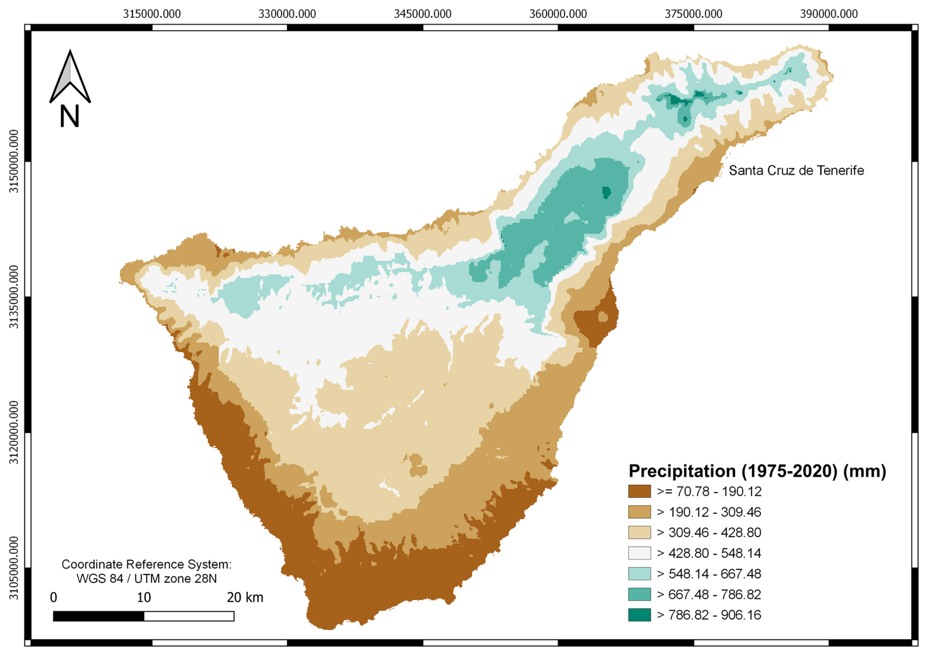
Figure 4Precipitation of Tenerife (Canary Islands) during the period 1975–2020 measured in millimeters (mm). Source: adapted from the Gobierno de Canarias (2023a).
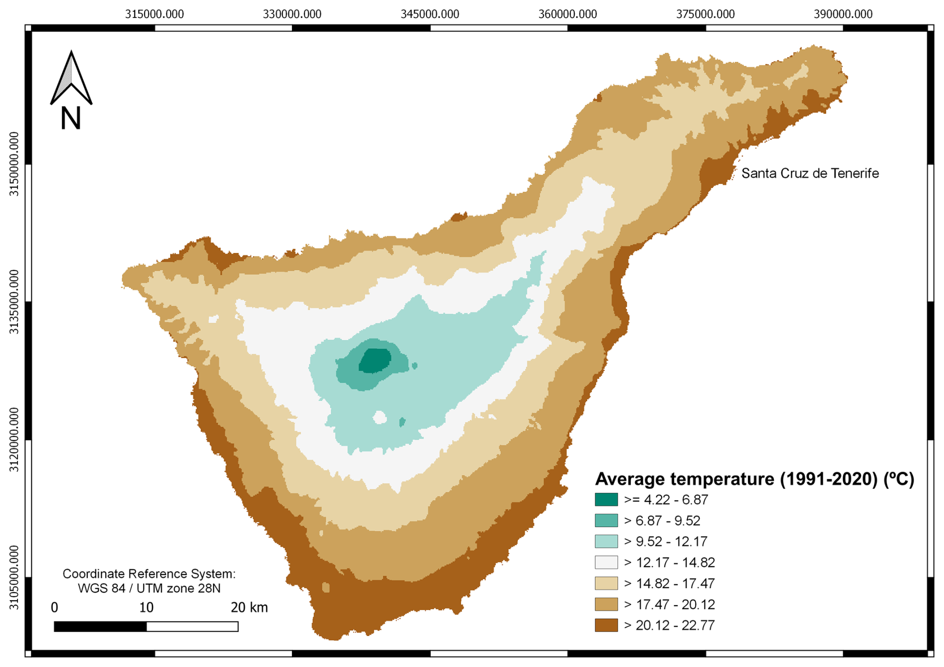
Figure 5Average temperature of Tenerife (Canary Islands) during the period 1991–2020 measured in degrees Celsius (°C). Source: adapted from Gobierno de Canarias (2023b).
Beyond these endogenous and exogenous geophysical, hydrological and meteorological processes, Tenerife has been affected by multiple derived hazards. These include tectonic and rainfall-induced landslides of varying magnitudes, floods caused by torrential rains, heavy swell and tsunamis, lava flows and human-induced forest fires, droughts and plagues, tsunamis caused by distal earthquakes, or even the effects of the Saharan dust. For this reason, Tenerife, like many other volcanic islands, presents an intrinsically multi-hazardous nature that requires an in-depth analysis of the hazards to which it is exposed and institutional attention to mitigate their effects.
Natural hazard risk management in the Canary Islands operates within a multi-level governance framework in which each island council (Cabildo) coordinates its own emergency and risk planning, in line with regional and national civil protection structures. In Tenerife, the Territorial Insular Emergency Plan for Civil Protection (Cabildo de Tenerife, 2020) acts as the territorial umbrella plan, supported by hazard-specific emergency response plans such as PEVOLCA (volcanic risk), PESICAN (seismic risk), PEINCA (flood risks), INFOCA (wildfire risks), or PEFMA (for adverse meteorological phenomena).
The PEIN identifies several natural hazards for Tenerife, including hydrological hazards, seismic activity, volcanic eruptions, adverse atmospheric phenomena, slope movements, locust plagues, and forest fires. Additionally, the PEIN conducts a comparative risk analysis to classify these hazards based on their probability of occurrence and potential consequences, thereby establishing priorities for planning and response strategies. This classification is based on historical data regarding hazardous events that have impacted the island's territory (hazard assessment) and an evaluation of vulnerable elements (vulnerability assessment), including the population, critical infrastructure, cultural heritage, and protected areas.
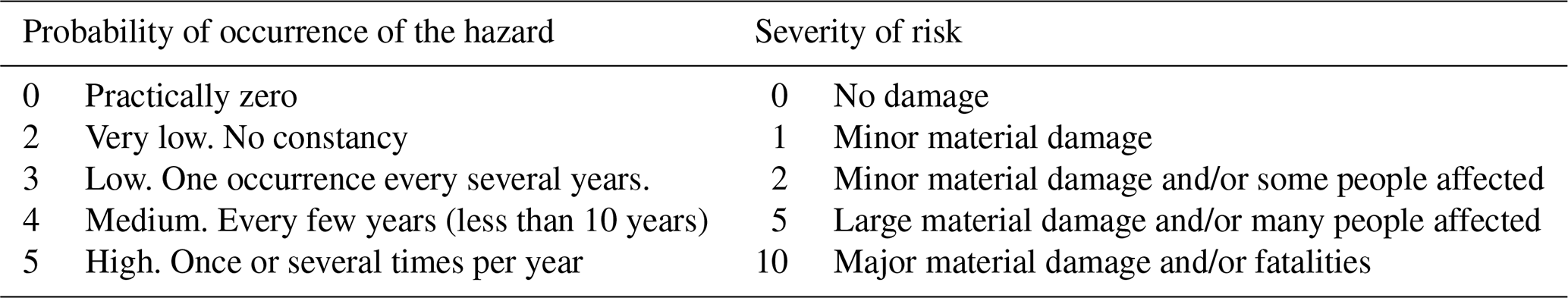
The PEIN risk assessment considers two key parameters: probability (the estimated or projected frequency of an event) and severity (the extent of potential damage). The risk level is determined using an index (1) that integrates these factors, expressed as follows:
The PI and SI can be as shown in Table 1.
Table 1Risk Probability and Severity Indices. Source: Cabildo de Tenerife (2020).
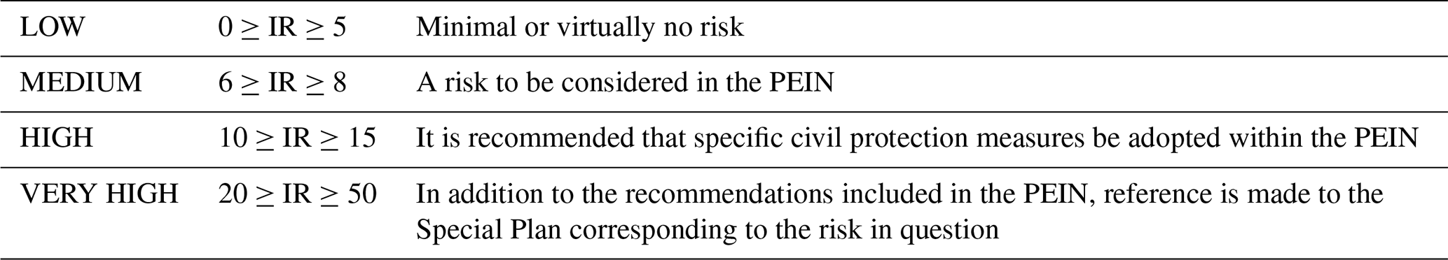
Based on the value obtained by multiplying each PI and SI assigned to each hazard, risks can be categorised according to their RI as shown in Table 2.
Thus, the risk classification obtained and included in the PEIN is shown in Table 3.
Table 3Classification of the Level of Risk of Different Natural Phenomena in Tenerife According to Their Probability and Severity. Source: Cabildo de Tenerife (2020).
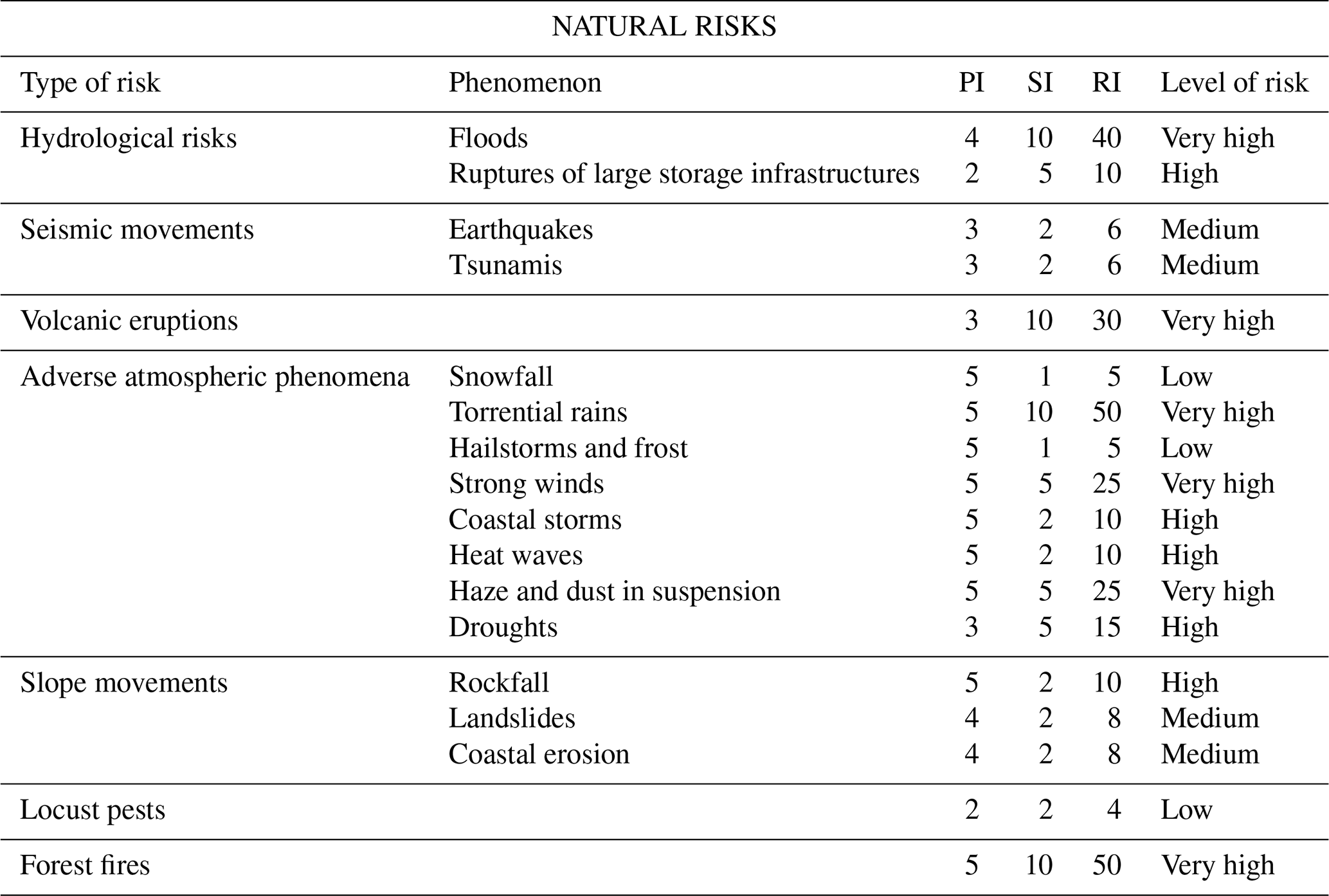
According to this classification (Tables 2 and 3), forest fires and torrential rainfall represent the greatest risks to the population of Tenerife, given their high frequency and significant impact. These are followed by floods, volcanic eruptions, strong winds, and Saharan dust storms (haze). In contrast, snowfall, hailstorms, frost, and locust plagues are identified as the least significant risks. However, this risk probability must be periodically reassessed in light of historical records and the potential recurrence of natural events observed in the past.
Beyond these identified natural hazards, climatic patterns, affecting average temperature and precipitation levels, are expected to be altered by climate change as in many other areas (IPCC, 2022). According to IPCC WGI Interactive Atlas data (https://interactive-atlas.ipcc.ch/, last access: 3 February 2023) (Gutiérrez et al., 2021; Iturbide et al., 2021), under a 1.5 °C global temperature increase, Tenerife's average temperature could rise by 1.1 °C (SSP5-8.5), while annual precipitation could decrease by 18.5 %. These projected changes may exacerbate existing natural hazards, including forest fires, torrential rainfall, flash floods, droughts, and haze, in addition to reducing water reserves.
In addition, Tenerife also faces a critical challenge due to its insular nature: sea level rise. Given its geographical setting, this phenomenon is of particular concern, as it threatens coastal urban areas and infrastructure. NASA has developed sea level rise projections based on data from the IPCC Sixth Assessment Report (Fox-Kemper et al., 2021; Garner et al., 2022; IPCC, 2022; Kopp et al., 2023). These projections, available through an online interactive tool (https://sealevel.nasa.gov/ipcc-ar6-sea-level-projection-tool, last access: 16 May 2023), provide estimates relative to the 1995–2014 baseline for five Shared Socioeconomic Pathway (SSP) scenarios and five future Global Mean Surface Temperature (GMST) levels (2080–2100). Sea level projections are also provided at five specific future Global Mean Surface Temperatures (from 2080–2100): 1.5, 2, 3, 4 and 5 °C.
According to these projections, in the worst-case scenario (SSP5-8.5, Fig. 6), Tenerife could experience a sea level rise of 1.53 m, whereas in the best-case scenario (SSP1-1.9, Fig. 6), the rise would be 0.75 m. This represents a serious threat, as most urban centers are located along the island's coastline (Fig. 1a). Furthermore, Tenerife is undergoing rapid population growth, necessitating further urban expansion, which could lead to increased exposure to other natural hazards in inland areas.
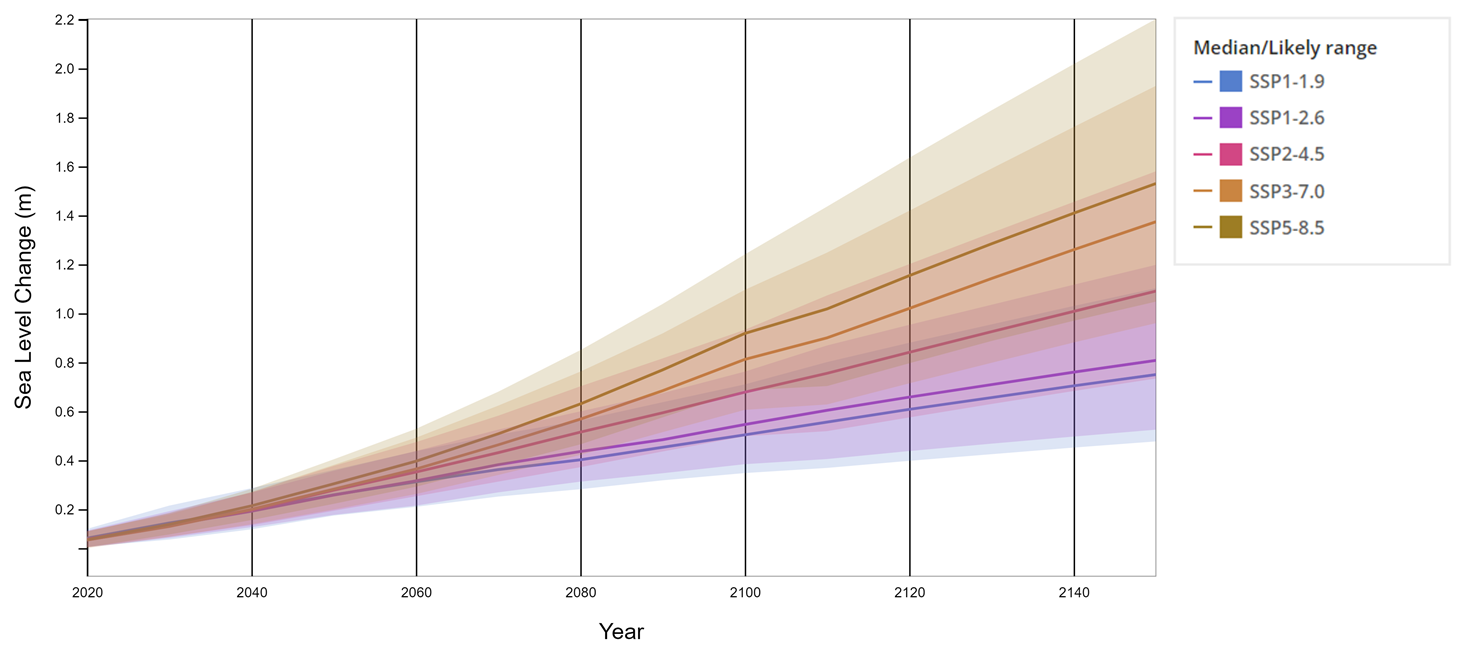
Figure 6Projected sea level rise under different SSP scenarios for Tenerife. Source: Fox-Kemper et al. (2021), Garner et al. (2022), Kopp et al. (2023), Creative Commons Attribution 4.0 International License.
* Note: By 2100, the SSP1-1.9 scenario limits global warming to roughly 1.5 °C above pre-industrial levels (1850–1900), following a temporary overshoot, and anticipates achieving net-zero CO2 emissions around mid-century. The SSP1-2.6 pathway maintains warming below 2.0 °C (median estimate), with carbon neutrality projected in the latter half of the century. SSP2-4.5 aligns with the higher range of emission levels expected from current Nationally Determined Contributions (NDCs) by 2030. The IPCC Special Report on 1.5 °C (SR1.5) estimated that NDC implementation could lead to a temperature increase between 2.7 and 3.4 °C by 2100, which falls within the upper bounds of SSP2-4.5 projections. Although several countries introduced 2050 net-zero targets by the end of 2020 – consistent with SSP1-1.9 and SSP1-2.6 – the overall emissions outlook for 2030 remained largely unchanged. The SSP2-4.5 trajectory modestly diverges from a baseline scenario with no additional climate policies, with a median projected warming of approximately 2.7 °C by century's end. SSP3-7.0 represents a medium-to-high emissions pathway lacking new climate interventions, marked by substantial non-CO2 emissions such as aerosols. SSP5-8.5 constitutes a high-end reference scenario also assuming no further climate policies, and such emission levels are only realized in Integrated Assessment Models under the fossil-fueled development storyline of SSP5. Uncertainty ranges (17th–83rd percentiles) are included, and temperature projections are referenced to a 1995–2014 baseline. The accompanying figure illustrates projected total sea level change and associated uncertainties. Source: Fox-Kemper et al. (2021), Garner et al. (2022), Kopp et al. (2023).
While climate change does not directly affect the frequency or magnitude of volcanic eruptions or earthquakes, it may worsen associated secondary hazards. For instance, desertification and increased soil erosion could destabilize slopes, making them more prone to landslides during seismic events or volcanic unrest. Given these risks, it is crucial to thoroughly analyze past natural hazards in Tenerife to develop effective risk mitigation strategies and enhance resilience in the face of future climate-related transformations.
Furthermore, this single-hazard planning model on which the Spanish risk management system is based, in which each hazard is managed separately, lacks mechanisms for the coordination or integrated communication of multiple risks. The historical multi-hazard dataset presented here offers an opportunity to address this gap by providing a shared, cross-hazard evidence base that can inform more holistic and interconnected disaster risk reduction strategies in the future.
While the PEIN identifies a wide range of hazards for Tenerife, our historical dataset focuses on volcanic eruptions, earthquakes, tsunamis, landslides and rockfalls, and floods. This selection was determined by four main factors:
-
Documented historical occurrence (1494–2020) – Only hazards with recurrent, well-documented events over at least several centuries were included, ensuring consistency and reliability in long-term analysis.
-
Availability and quality of historical records – Hazards such as hailstorms, heatwaves, or droughts are relevant but lack sufficiently detailed and consistent historical documentation to support robust analysis in this version of the dataset.
-
Cascading and multi-hazard potential – Selected hazards are known to trigger or be triggered by other events, making them particularly relevant for multi-hazard analysis.
-
These hazards are the ones covered by Special Plans (see Sect. 3) designed to manage this type of hazard and any resulting emergencies.
We compiled all existing records of historical events produced by these geophysical and hydrological hazards that have impacted the island of Tenerife, covering the period from its colonization by the Castilians around 1494 to the present day. This compilation was conducted as part of the doctoral thesis of López-Saavedra (2023) and was completed in 2022. Consequently, the dataset spans from 1494 to 2020, which was selected as the endpoint in the work of López-Saavedra (2023). This time frame provides a sufficiently broad period to ensure high-quality results. The complete record is presented in Table S1 in the Supplement.
For each event, we collected data on the following variables:
-
Event (e.g., type, specific name, etc.)
-
Start and end dates
-
Location (i.e., place of origin)
-
Cascading effects and associated hazards
-
Main affected areas
-
Fatalities
-
Injuries
-
Displacements
-
Economic, social, and environmental losses
-
Management and resilience measures (actions taken before, during, and after the event, as well as recovery efforts)
-
Additional observations (e.g., measurement data, magnitudes, relevant notes)
The primary objective of this first stage was to compile a comprehensive, data-driven historical record of all hazard events affecting Tenerife over the last five centuries, without introducing interpretive bias at the data-entry stage. For this reason, events were recorded as independent entries, without assigning explicit interrelationships (e.g., primary vs. secondary hazards, triggering chains, or compound events), except in cases where these were explicitly documented in the source material. This ensures that the dataset captures the complete range of events – regardless of whether their causal connections are already known or remain to be identified – and forms a robust foundation for subsequent analytical processing. Some cascading events were labelled as such when clearly stated in historical sources, but in most cases, the identification of hazard interactions will be carried out during the analysis phase. While this initial compilation phase deliberately avoids interpretive classification, we fully recognise the importance of established multi-hazard frameworks for subsequent analysis and interoperability. Future stages of this research will explicitly incorporate hazard typologies and interaction categories from both the scientific literature (e.g., Gill and Malamud, 2016; Kappes et al., 2012; López-Saavedra and Martí, 2023) and operational frameworks (e.g., UNDRR). This staged approach – objective data gathering first, analytical classification later – ensures both transparency in the dataset's construction and adaptability for integration into broader multi-hazard risk assessment and modelling efforts.
As a documentary foundation, we relied on previously compiled historical records for each type of event. For volcanic eruptions, we used the Global Volcanism Program database from the Smithsonian Institution (2013) and studies by Carracedo (2008) and Romero (1991). For earthquakes, we consulted the Catalog and Seismic Bulletins for the Canary Islands, maintained by the National Geographic Institute (IGN, 2021), and supplemented this with the Review of the Seismic Catalog of the Canary Islands (1341–2000) (IGN, 2020). The dataset was limited to epicenters within latitudes 29 and 27° and longitudes −15 and −18°, covering Tenerife and its offshore surroundings. Additionally, we filtered earthquakes by magnitude, selecting those with mbLg(L)≥3.5, as they are considered to release sufficient energy to be perceived by the population, potentially causing damage or serving as precursors to volcanic eruptions.
For landslides, we used the Movements Database of the Geological and Mining Institute of Spain (IGME, 2016). For floods, we consulted event catalogs from Arroyo (2009), Quirantes et al. (1993), Dorta (2007), and Pinto (1954), as well as the Plan de Defensa Frente Avenidas de Tenerife (PDA) from the Tenerife Water Council (Consejo Insular de Aguas de Tenerife, 2004). Finally, for tsunamis, we referenced the study by Galindo et al. (2021).
Beyond these sources, we updated and expanded the records primarily through historical chronicles housed in the Provincial Historical Archive of Santa Cruz de Tenerife, the Diocesan Historical Archive of San Cristóbal de La Laguna, and the Municipal Historical Archive of San Cristóbal de La Laguna. Additionally, we examined documents from the Digital Press Archive (Jable) of the University of Las Palmas de Gran Canaria (ULPGC) and the Virtual Library of Historical Press, managed by the Subdirectorate General of Library Coordination of the Ministry of Culture and Sport of the Government of Spain. These documentary sources were further complemented by numerous scientific articles, historical newspaper archives, and official documents issued by the Cabildo of Tenerife and other islands. We also incorporated legal documents published in the Official State Gazette (BOE) of Spain, including Royal Decrees, Laws, and Orders enacted in response to past hazards. The complete bibliography is listed as a Supplement.
Cross-referencing multiple sources enabled us to verify the dataset for inconsistencies, errors, or missing values, thereby improving its reliability and accuracy. The historical record of Tenerife underwent a preliminary qualitative analysis. We evaluated the frequency and duration of each type of event, as well as their locations and areas of impact. We qualitatively identified recurring patterns or trends by analyzing commonalities in the temporal and spatial distribution of events over the studied period. Additionally, we assessed the socioeconomic consequences of these events to determine their severity, considering economic losses, approved recovery budgets, the type and quantity of damaged infrastructure, and the extent of the damage (e.g., flooded, burnt, damaged, destroyed, devastated, affected). Finally, we analyzed the risk management measures implemented during and after these events, evaluating their effectiveness in mitigating impacts and enhancing resilience.
The historical record of multi-hazard events analyzed in this study was compiled into a dataset, which is publicly available in the DIGITAL.CSIC repository under the https://doi.org/10.20350/digitalCSIC/17088 (López-Saavedra et al., 2025).
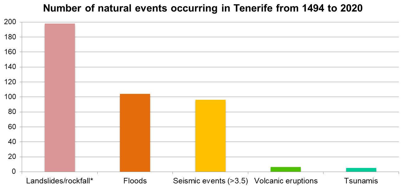
Figure 7Frequency of different types of natural hazards compiled in this analysis that occurred in Tenerife between 1494 and 2020.
* Note: Rockfalls/landslides display the number of events of this type occurring between 1941 and 2020 due to the lack of earlier data, hence the subdued color bar. It is important to note that only seismic events with a magnitude greater than 3.5 mbLg(L) have been considered.
From 1494 to 2020, a total of six volcanic eruptions occurred in Tenerife, two of which could be considered part of the same eruptive event, resulting in a total of five distinct occurrences. Additionally, 96 seismic events with a magnitude greater than 3.5 mbLg(L) were recorded during this period, 13 of which – whether seismic swarms or individual earthquakes – were considered of volcanic origin due to their association with previous eruptions (Fig. 2). Furthermore, 104 floods and five tsunamis were documented, most of which were triggered by distal earthquakes, except for one caused by a landslide on the coast of Tenerife. The frequency of these events is shown in Fig. 7.
Regarding landslides and rockfalls, the available records cover a much shorter period. Between 1941 and 2020, up to 198 such events were documented, although the exact date remains unknown for 71 of them. According to these data, landslides and rockfalls could be considered the most frequent hazards, followed by floods. However, it is important to note that only earthquakes with a magnitude greater than 3.5 mbLg(L) were considered due to their potential impact on the population, although seismic activity of any magnitude is the most frequent event in Tenerife (IGN, 2021). Details can be found in Table S1 (López-Saavedra et al., 2025).
The dataset reveals that most landslides and rockfalls during the study period occurred along roadsides, closely linked to human activities such as road construction, which results in steep, unstable slopes. Another common location for these events is on coastal cliffs and ravines throughout the island. The data also indicate that, in some years, up to 22 such events were recorded. They generally occur more frequently in February and November, followed by January, October, and December, although they can also happen throughout the rest of the year. According to the information presented in Table S1, these events typically occur very quickly, lasting from a few seconds to a few minutes. In some cases, instability persists for hours or days, but the actual rockfall is instantaneous. In general, the causes of these events are difficult to determine because the direct cause is not usually observed, but rather the event once it has already occurred. However, most landslides or rockfalls recorded in the dataset have not triggered other events in a cascade effect, with the exception of the landslide on 7 July 1941, caused by the impact of a wind wave, causing part of a cliff to collapse into the sea and triggering a tsunami that inundated the coast of Santa Cruz de Tenerife (Fig. 1a).
Between 1941 and 2020, landslides and rockfalls caused a total of 16 fatalities, most of them occurring on beaches or in ravines, such as the Infierno Ravine (west of Tenerife), a popular hiking route, or in houses near slopes. Additionally, at least 10 injuries were recorded. Some of these events may have caused prolonged closures of beaches or trekking areas, with economic and reputational effects on tourism-dependent municipalities. In some cases, victims were tourists, which raises questions about impacts on risk perception, insurance, and emergency response capacity. However, compared to other events, in these cases big population preventive evacuations were not done and, in the cases were no fatalities were produced, economic losses were less significant than other disasters such as those produced by floods or volcanic eruptions. At the same time, cleanup and recovery efforts in affected areas are usually quick and straightforward, with normal conditions restored within the same day or the following days, due to the smaller affected area compared to other hazards.
Regarding floods, they are concentrated mainly in November and December, with less frequent occurrences in October and January, followed by February, March, and April. However, while autumn and winter floods remain relatively constant, primarily occurring in November and December, floods in spring have shown a slight trend toward increased frequency from January to March, extending into April and May, and even sporadically occurring in August. This seasonal distribution aligns with the Atlantic storm patterns mentioned in the “Geographical, geological and climatic context” section. Flood events generally last between one and three days, though some persist for up to a week. Most floods occur in the northern part of the island, coinciding with the areas of highest precipitation, as shown in Fig. 4.
Like landslides and rockfalls, floods are often triggered by a preceding event, typically meteorological events such as heavy storms, but can also be triggered by landslide dam failures or volcanic triggers. However, unlike landslides and rockfalls, floods can themselves initiate cascading hazards. These multi-hazard scenarios are typically characterized by intense rainfall leading to flash floods, which overflow through ravines and inundate population centers in low-lying coastal areas. Additionally, these floods are usually accompanied by significant sediment transport. To a lesser extent, some floods are also caused by wave action during storm events with strong winds.
Floods are responsible for significant human and economic losses. According to recorded events, approximately 800 fatalities were attributed to floods throughout the study period, although historical accounts suggest that the actual number may be higher. Numerous injuries and evacuations were also reported. Economic losses recorded between 2000 and 2020 alone exceeded EUR 37 billion. Typically, these losses result from the destruction and damage of houses, buildings, infrastructure, and municipal facilities. It is important to note that due to technological advancements, inflation, and urban expansion, economic losses have increased in value toward the end of the study period. Available data indicate that floods pose greater challenges for emergency management and recovery than other hazard types. In earlier centuries, emergency management was primarily the responsibility of local mayors and municipal authorities, supported by the Insular Council. Recovery efforts were largely carried out by local workers with strong community participation. However, in recent times, these tasks have been integrated into the Spanish national risk management system.
Tectonic earthquakes affecting Tenerife are also relatively frequent and typically have their epicenters in the surrounding sea. Many of these earthquakes occur in the marine area between Gran Canaria and Tenerife, over the fault zone depicted in Fig. 2. On land, seismic activity is most commonly recorded in the Icod and Orotava Valleys in the north of the island. The strongest perceived shaking is concentrated in the northern region, with lesser effects in the metropolitan, northwestern, eastern, and southern zones. These earthquakes generally last a few seconds to a few minutes, though foreshocks and aftershocks may persist for several days before and after the mainshock.
In the context of Tenerife and the study period, tectonic earthquakes typically do not trigger additional hazards, and their immediate effects are often negligible. Occasionally, they have caused landslides and rockfalls. No fatalities were recorded during the study period, either because they did not occur or because they were not documented. Few injuries and evacuations were reported, with panic among the population being the most common consequence. No significant damage or economic losses were documented. The highest recorded magnitude was M 6.3 (M = estimation of Mw moment magnitude in the Canary Islands based on correlations obtained in Rueda et al., 2020), though most recorded events were below M 5.0. The highest calculated epicentral intensity was 7.3. Volcanic earthquakes, however, tend to have higher epicentral intensities and magnitudes exceeding M 6. Due to their characteristics, these events did not require significant management measures or recovery efforts.
Volcanic eruptions were the least frequent events during the study period. The first documented eruption, corroborated by geological evidence, was the Siete Fuentes-Fasnia eruption, which began on 31 December 1704, in eastern Tenerife. Seventeen days after its conclusion, the Arafo eruption began in the nearby Güímar Valley. The next eruption, Garachico (Arenas Negras), occurred 404 d after the end of the Arafo eruption, in the northwest of the island. Between the end of this event and the start of the Chahorra (Narices del Teide) eruption in 1798, 91 years, 11 months, and 25 d elapsed. The last recorded eruption was the Chinyero event, occurring from 18 to 27 November 1909, in northwest Tenerife, 111 years, 2 months, and 3 d after the previous eruption.
All recorded eruptions took place in rift zones. The Siete Fuentes, Arafo, and Fasnia eruptions originated in the Dorsal Rift Zone; the Arenas Negras and Chinyero eruptions in the Santiago Rift Zone; and the Narices del Teide eruption on the southwestern flank of Pico Viejo, though it remains unclear whether it should also be classified under the Santiago Rift Zone. These eruptions produced multiple associated hazards, including seismic activity, explosions, ashfall, pyroclastic ejections, lava flows, and landslides. The affected area varied depending on the hazard.
All historical eruptions in Tenerife were of the Strombolian type, with Volcanic Explosivity Index (VEI) (Newhall and Self, 1982) values between 2 and 3 and lava flow volumes ranging from 0.004 to 0.035 km3.
In summary, Table 4 shows the possible scenarios that can be found in Tenerife given its historical record.
Table 4Possible Natural Hazard Scenarios for Tenerife According to its Historical Record (1494–2020).
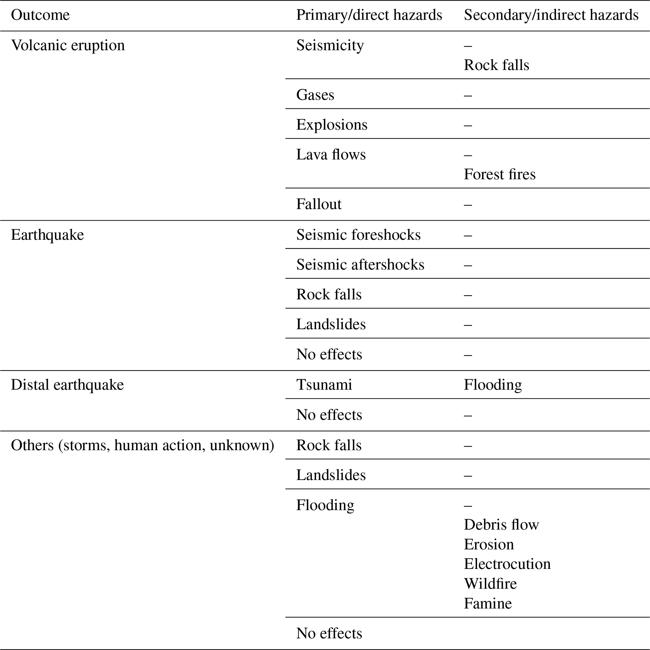
The recorded events enabled us to compile a catalog of many possible multi-hazard scenarios according to what have occurred in Tenerife over the past 526 years. Therefore, any of these events can be considered to have a probability greater than zero of recurring in the future. However, this is not an exhaustive list of all possible scenarios for the island, as some events with much longer recurrence periods, such as major eruptions, may have occurred before the analyzed period. Thus, the dataset enables the identification of plausible, historically grounded scenarios. Furthermore, future scenarios may differ, since emerging hazards and changing system dynamics may generate new or previously unrecorded interactions. This is especially for those scenarios involving weather-related hazards due to the effects of climate change. Nevertheless, all the scenarios listed here are more likely to occur in the short-term than any scenario not included in Table 4.
Comparison of the results from our historical multi-hazard dataset with the PEIN (Cabildo de Tenerife, 2020) risk ranking reveals both consistencies and discrepancies that underscore the value of empirical, cross-hazard analysis. For volcanic eruptions, the PEIN assigns a probability index of 3, which aligns with our findings, as eruptions occur on the order of decades. However, the severity index of 10 – equal to that of floods – merits further consideration. Historical eruptions in Tenerife have not caused direct fatalities, whereas floods have repeatedly resulted in loss of life, greater economic damage, and higher frequency (probability index 4–5). Climate change is also likely to increase flood frequency and intensity, further widening the gap in overall risk. While it is reasonable that floods rank above eruptions in risk, the current scale may understate this difference. For landslides and rockfalls, the PEIN levels are broadly consistent with our dataset; however, our analysis reveals strong associations with anthropogenic factors, particularly road construction. Additionally, extreme rainfall events – projected to become more frequent – are likely to exacerbate both hazards, suggesting that their probability and impact could increase in the coming decades. In the case of earthquakes, our dataset indicates that events exceeding magnitude 3.5 occur almost annually, supporting an increase in the PEIN probability index from 3 to 4 or 5. Conversely, the severity index could be reduced from 2 to 1, reflecting the limited damage historically recorded. Moreover, the PEIN classification does not distinguish between tectonic earthquakes and those of volcanic origin, an important consideration for risk interpretation. Finally tsunami classifications are consistent with our findings. However, most are associated with distant earthquakes, the probability of which should be studied in greater depth, as should the trajectories of the waves. The anthropogenic factor of urban expansion along the coastline should also be taken into account.
The absence of multi-hazard cause–effect considerations in the PEIN means that hazard rankings are still derived from a single-hazard perspective. Incorporating cascading and coincident hazard interactions into probability and severity assessments would allow for a more holistic and realistic appraisal of risk, which in turn should be reflected in both ranking systems and emergency plans.
The value of this comparison lies in demonstrating how a data-driven, historical multi-hazard perspective can complement and refine existing institutional rankings. By grounding hazard probability and severity assessments in scientific evidence derived from five centuries of recorded events, this dataset enables a more objective appraisal of risk than reliance on single-hazard classifications alone. It also provides a consistent cross-hazard framework, allowing for the identification of trends, under- or overestimations, and potential cascading effects that may not be visible within current planning tools. For that reason, this historical data compilation allowed us to identify both successful strategies and areas for improvement in the management of natural hazards. Based on these analyses, we extracted valuable insights and lessons from the dataset. By identifying patterns and recurring trends, we also identified common patterns of vulnerability inferred from observed impacts, such as location-specific trends (e.g., recurrent flood damage in low-elevation coastal settlements), severity of impacts (displacement, fatalities, infrastructure damage), and systemic weaknesses in recovery. At the same time, persistent challenges and, thus, possible resilience measures are discussed in this section. Collectively, these findings contributed to the development of recommendations and guidelines for future hazard preparedness, response, and recovery efforts in Tenerife. This preliminary assessment also provided insight into the possible scenarios that could unfold on the island, and must be used as a scenario-support tool, not a predictive one. At the same time, the proposed strategies and measures are recommendations based on the results obtained, but a more detailed analysis of their feasibility is necessary.
According to the records, floods are most likely to occur during the autumn-winter seasons, with the highest probability between November and January. However, the data suggest that flooding events may also extend into the winter-spring period, from January to May. The most probable cause of these scenarios is heavy rainfall associated with storms, leading to the overflow of ravines. This pattern aligns with the distribution of storms throughout the year (i.e., intense waves as a cause of flooding are less frequent than storms in Tenerife, and even less so due to tsunamis; other causes, such as landslides obstructing the ravine course and triggering upstream flooding, are not considered due to a lack of evidence). The island's subtropical climate, influenced by Atlantic storms, contributes to these heavy rainfall events, particularly during these periods of the year. These storms typically approach from the ocean towards the land from the north, resulting in the heaviest precipitation in the northern and northwestern regions of the island.
Given Tenerife's steep slopes, heavy rainfall is also expected to trigger flash floods – sudden and rapid flooding events characterized by swift-moving water, which can be particularly hazardous due to their speed and the limited time available for evacuation or preparation. The main hazard associated with these events is the overflow of ravines, which typically occurs when they reach flatter areas or zones modified by human activity, such as channeling, bridge construction, flow alterations, or paving. The most affected municipalities include Santa Cruz de Tenerife, San Cristóbal de La Laguna, Garachico (particularly by waves), San Andrés, La Orotava Valley, Güímar, Puerto de la Cruz, Los Realejos, and Icod de los Vinos, among others (Fig. 1a). Additionally, torrential floods transport large volumes of sediment through ravines, and when combined with landslides occurring simultaneously, they result in debris flows that deposit mud and large rocks in overflow areas. This exacerbates the impact and complicates cleanup and recovery efforts.
Overall, the frequency of this phenomenon has remained relatively constant throughout the study period, but a slight increase has been observed in recent years. However, its impact has clearly intensified, with flooding events affecting metropolitan and coastal areas more frequently. The findings indicate that this scenario causes the most damage and has the potential to become even more severe in the future. The distribution of major population centers is a critical factor, as most are situated in areas with high rainfall, often along or near major ravines. Many of these ravines have been paved and converted into streets, while others have been modified with infrastructure that disrupts natural drainage toward the sea. It is crucial to recognize that water will always follow its natural course, meaning that reactive damage repairs, rather than proactive risk mitigation measures, are likely to have greater economic and social consequences.
To mitigate flood risks, the following measures should be considered:
-
Clearing ravines to reduce solid load during torrential floods.
-
Creating water retention areas, such as parks, gardens, or other open, permeable spaces to accommodate controlled water overflow.
-
Reforesting headwaters and high-precipitation areas to reduce runoff and mitigate wildfire risk through improved forest management and removal of combustible materials.
-
Increasing channel permeability by avoiding paved ravine beds.
-
Raising the height of bridges crossing ravines to prevent obstruction during floods.
-
Improving drainage toward the sea by cleaning and expanding the sewage system, opening its outlet to the beach while protecting it from sand blockages during storms, and increasing the slope toward the sea to prevent wave intrusion, taking into account projected sea-level rise (Fig. 6).
-
Preserving the natural alignment of ravines and integrating land-use planning accordingly.
All these measures, along with others, should be designed based on detailed flood hazard mapping, taking into account potential secondary risks arising from their implementation.
Another common hazard in Tenerife is rockfalls and small-scale landslides. These typically occur along road cuts or within ravines, the latter being less frequented by tourists. Consequently, such events generally do not result in fatalities, injuries, significant damage, or high costs. However, notable exceptions include the landslide in Barranco del Infierno on 26 October 2015, which resulted in one fatality and four injuries, and the rockfall on 1 November 2009, in Los Gigantes (west coast), which caused the deaths of two people at Santiago del Teide beach. Another significant landslide occurred on 27 January 1947, in Tacoronte, resulting in five fatalities (IGME, 2016).
It is worth noting that historical records likely underestimate the occurrence of such events, as they appear less frequently documented compared to other hazard types. This limitation could not be fully addressed, as it is not possible to assume a constant frequency over time; the occurrence of landslides depends on multiple factors distinct from those influencing other hazards. For example, road construction can increase slope failures, while variations in rainfall and other environmental factors also play a role. However, while it cannot be assumed that past frequency was significantly lower, records indicate that despite the high frequency of these events in recent years, they have not caused substantial economic or social losses, suggesting they may not represent a critical future threat. Nevertheless, their consequences, such as road closures and risks to individuals, should not be overlooked. Moreover, in contexts where no direct damage is recorded, such events may remain absent from historical datasets. For that reason, for some types of hazards, such as landslides or rockfalls, relying on historical record data may result in underestimating unreported or undocumented events in uninhabited or infrastructure-free areas.
Despite uncertainties in the data, records indicate that rockfalls and landslides result from various factors, including temperature fluctuations, rainfall, and earthquakes acting on slopes in combination with gravity. Most events occur along roads or in areas modified by human activity. In some cases, landslides follow periods of rainfall, earthquakes, floods, strong winds, or intense waves. However, their occurrence is more evenly distributed throughout the year than floods, making it difficult to establish a single triggering cause. Some events have been preceded by earthquakes, which may have destabilized slopes, leading to landslides in subsequent days.
Given this, preparedness measures are essential, particularly after heavy rainfall and seismic activity. Recommended actions include:
-
Modifying the slopes of roadsides prone to landslides.
-
Installing protective structures such as meshing and bolting to retain small landslides.
-
Removing unstable rock masses from road embankments.
-
Conducting thorough geological and geotechnical studies before creating new road cuts.
-
Preserving the original topography as much as possible to avoid the creation of excessively steep slopes, which, despite their practicality in volcanic terrain, may lead to long-term consequences.
Earthquakes felt in Tenerife generally originate from either tectonic or magmatic sources. Tectonic earthquakes are typically associated with the transform fault running through the channel between Gran Canaria and Tenerife. This area exhibits the highest seismic activity in the Canary Islands, with 400–500 earthquakes per year below 2.5 mbLg, of which fewer than a dozen exceed this magnitude (IGN, 2022). Earthquakes recorded in Tenerife have reached maximum intensities of 1–6 on the MSK-64 scale (Medvedev and Sponheuer, 1964) and rarely cause damage. Notable exceptions include the 9 May 1989 earthquake (M5.0), which had a maximum epicentral intensity of 6.7, causing minor structural damage (Mezcua et al., 1992).
Magmatic earthquakes, often occurring in swarms, have not caused significant damage in Tenerife. Other hazards affecting the island include Saharan dust storms, wildfires, and tsunamis, though the latter are rare. Haze originating from the Sahara, which, in addition to causing respiratory problems, has occasionally been accompanied by locust plagues, as occurred in 2004. Forest fires, often triggered by heat waves and/or human activity, represent another significant hazard. Notably, the 2007 wildfire burned approximately 15 000 ha – the same number of hectares that were affected again in the 2023 fire. The presence of haze can further exacerbate wildfire conditions. Additionally, while tsunamis are less common, historical records indicate the occurrence of a tsunami on 31 March 1761. However, some of these records are not well substantiated. Nevertheless, as an island located in the middle of the Atlantic Ocean, Tenerife remains susceptible to any tsunami that propagates through this region.
To further enhance our understanding and improve the precision and accuracy of the data used in this study, it is crucial to conduct additional fieldwork and integrate citizen science initiatives. This roadmap highlights the necessity of comprehensive geological studies through field campaigns in Tenerife and underscores the importance of investing in Earth sciences and fundamental geological research, particularly in the field of physical geology. Fieldwork plays a pivotal role in scientific research, especially in geological studies. Direct observation and data collection in the field provide critical insights into processes and phenomena occurring within a given region. In the case of Tenerife, conducting field campaigns will yield invaluable information on the island's geological characteristics, including its volcanic activity, tectonic processes, and hazard-prone areas. By supplementing our dataset with new field observations, we can refine our understanding of the local geology and enhance the accuracy of our analyses.
It should be noted that implementation of these measures, could influence other hazards – sometimes positively, by creating co-benefits, and sometimes requiring careful management of trade-offs. For example, restoring natural drainage and riparian buffers not only mitigates flood peaks but can also reduce sediment loads that contribute to coastal erosion, while improved land-use planning in flood-prone areas may also lower exposure to landslides triggered by heavy rainfall. Conversely, certain flood-control infrastructures, if poorly designed, could exacerbate downstream flooding or disrupt sediment supply in ways that affect coastal stability. These observations align with evidence from similar insular volcanic regions (e.g., Kappes et al., 2012; Ruangpan et al., 2020), where integrated approaches have demonstrated the benefits of aligning measures across hazards. In the case of Tenerife, several of the proposed measures are already partially embedded within existing Plans, such as the Flood Risk Management Plans (FRMPs) developed under Royal Decree 903/2010, which transposes the EU Floods Directive (2007/60/EC) into Spanish law. However, they are designed within a single-hazard paradigm, and currently do not explicitly integrate cascading or compound hazard scenarios. The historical multi-hazard dataset presented here could therefore complement these existing planning instruments by providing data-driven and scientifically grounded insights to better capture dynamic, interconnected risks and support the evolution toward a more holistic DRR strategy.
Moreover, incorporating citizen science initiatives can significantly contribute to the acquisition of valuable data. Citizen science involves engaging the public in scientific research, enabling individuals from diverse backgrounds to actively participate in data collection and analysis. In Tenerife and other regions, citizen scientists can assist by reporting observations, sharing photographs, and providing local knowledge of natural events and processes. Community involvement facilitates the collection of a broader range of data points, improves spatial coverage, and enhances our comprehension of the region's geological dynamics.
To effectively implement community-based engagement (which includes local wisdom, shared learning, and participatory resilience-building) and citizen science (focused on the observation, documentation, and interpretation of hazard events by citizens) initiatives, oriented to raise awareness of potential multi-hazard risks and resilience measures, it is essential to establish collaborative platforms and communication channels between scientists and the public. These platforms can streamline data sharing, provide standardized data collection protocols, and ensure the accuracy and reliability of the collected information. Engaging citizens in the scientific process not only expands the available dataset but also fosters public awareness and understanding of naturalhazards and their potential impacts.
While our analysis is grounded in a data-driven assessment of historical events, it is important to recognise that existing risk management strategies in Tenerife and the Canary Islands have been influenced by past decisions and accumulated institutional experience. Considering this historical dimension can help identify persistent constraints and, more importantly, reveal opportunities to introduce measures that strengthen and modernise current approaches. In this way, the dataset supports both evidence-based decision-making and the evolution toward more integrated and forward-looking landslide risk governance.
The dataset supporting the findings of this study is publicly available through the digital repository Digital.CSIC. The dataset can be accessed directly via the following DOI: https://doi.org/10.20350/digitalCSIC/17088 (López-Saavedra et al., 2025). No additional access tokens or review links are required.
The creation of a comprehensive multi-hazard dataset for Tenerife, encompassing events from 1494 to 2020, represents a pivotal step toward understanding and preparing for the diverse challenges faced by the island. Despite acknowledging the inherent uncertainties in the data, this catalog serves as a valuable resource for long-term multi-hazard assessments. The uncertainties highlighted in the discussion underscore the need for continuous research and fieldwork to refine our understanding.
Such datasets play a critical role in complementing short-term hazard assessments, guiding the design of monitoring networks, and informing the development of effective risk mitigation strategies. By fostering a deeper understanding of historical events, these datasets contribute to the formulation and implementation of disaster risk reduction policies. They serve as a cornerstone in strengthening regional risk management systems, enhancing resilience against a complex array of hazards.
While the dataset holds strong potential for advanced applications such as risk modelling and machine learning, its current version should be regarded as an initial step in a longer-term development process. At this stage, certain limitations remain – particularly in metadata standardisation, indicator definition, validation protocols, and interoperability – which may constrain its immediate use for such purposes.
The utility of this dataset extends beyond academic research, offering practical applications for regional policymakers and risk management authorities. As we navigate the uncertainties associated with natural hazards, the establishment of such datasets stands as a proactive measure, providing a foundation for informed decision-making and fostering a resilient and adaptive response to the challenges posed by Tenerife's dynamic geological landscape.
The supplement related to this article is available online at https://doi.org/10.5194/essd-18-2979-2026-supplement.
MLS: Conceptualization, Data curation, Formal analysis, Funding acquisition, Investigation, Methodology, Visualization, Writing – original draft preparation, Writing – review and editing; JM: Conceptualization, Funding acquisition, Methodology, Project administration, Resources, Supervision, Validation, Writing – review and editing; MMS: Data curation, Formal analysis, Methodology, Software.
The contact author has declared that none of the authors has any competing interests.
Publisher's note: Copernicus Publications remains neutral with regard to jurisdictional claims made in the text, published maps, institutional affiliations, or any other geographical representation in this paper. The authors bear the ultimate responsibility for providing appropriate place names. Views expressed in the text are those of the authors and do not necessarily reflect the views of the publisher.
This article is part of the special issue “Methodological innovations for the analysis and management of compound risk and multi-risk, including climate-related and geophysical hazards (NHESS/ESD/ESSD/GC/HESS inter-journal SI)”. It is not associated with a conference.
This work was partially supported by the EG grant EVE (DG ECHO H2020 Ref. 826292) and the CSIC grant MAPCAN (CSIC Ref. 202130E083). Marta López-Saavedra received an FPU PhD grant (FPU19/02413) from the Ministry of Science, Innovation and Universities of the Government of Spain. We thank the projection authors from Fig. 6 for developing and making the sea-level rise projections available, multiple funding agencies for supporting the development of the projections, and the NASA Sea-Level Change Team for developing and hosting the IPCC AR6 Sea-Level Projection Tool. We also thank the collaboration and dedication of Carlos Rodríguez, from the Provincial Historical Archive of Santa Cruz de Tenerife.
This research has been supported by the European Civil Protection and Humanitarian Aid Operations (grant no. 826292), the Consejo Superior de Investigaciones Científicas (grant no. 202130E083), and the Ministerio de Ciencia, Innovación y Universidades (grant no. FPU19/02413).
The article processing charges for this open-access publication were covered by the CSIC Open Access Publication Support Initiative through its Unit of Information Resources for Research (URICI).
This paper was edited by Robert Sakic Trogrlic and reviewed by Julia Crummy and one anonymous referee.
Abdel-Monem, A., Watkins, N. D., and Gast, P. W.: Potassium-Argon ages, volcanic stratigraphy and geomagnetic polarity history of the Canary Islands: Tenerife, La Palma and Hierro, Am. J. Sci., 272, 805–825, https://doi.org/10.2475/ajs.272.9.805, 1972.
Ancochea, E., Fúster, J. M., Ibarrola, E., Cendrero, A., Coello, J., Hernan, F., Cantagrel, J. M., and Jamond, C.: Volcanic evolution of the island of Tenerife (Canary Islands) in light of new K-Ar data, J. Volcanol. Geoth. Res., 44, 231–249, https://doi.org/10.1016/0377-0273(90)90019-C, 1990.
Anguita, F. and Hernan, F.: A propagating fracture model versus a hot spot origin for the Canary islands, Earth Planet. Sc. Lett., 27, 11–19, https://doi.org/10.1016/0012-821X(75)90155-7, 1975.
Anguita, F. and Hernán, F.: The Canary Islands origin: a unifying model, J. Volcanol. Geoth. Res., 103, 1–26, https://doi.org/10.1016/S0377-0273(00)00195-5, 2000.
Araña, V.: Litología y estructura del Edificio Cañadas, Tenerife (Islas Canarias), Estud. Geol.-Madrid, 27, 95–135, 1971.
Araña, V. and Ortiz, R.: The Canary Islands: tectonics, magmatism and geodynamic framework, in: Magmatism in Extensional Structural Settings. The Phanerozoic African Plate, edited by: Kampunzu, A. B. and Lubala, R. T., Springer-Verlag, Germany, 209–249, https://doi.org/10.1007/978-3-642-73966-8_9, 1991.
Arroyo, J.: Cinco siglos de la temperie canaria: cronología de efemérides meteorológicas, Asociación Canaria de Meteorología (ACANMET), Tenerife, https://www.acanmet.org/portal/media/formacion/Microsoft%20Word%20-%20CRONOLOGIA.pdf (last access: 2 September 2024), 2009.
Azorin-Molina, C., Menendez, M., McVicar, T. R., Acevedo, A., Vicente-Serrano, S. M., Cuevas, E., Minola, L., and Chen, D.: Wind speed variability over the Canary Islands, 1948–2014: focusing on trend differences at the land–ocean interface and below–above the trade-wind inversion layer, Clim. Dynam., 50, 4061–4081, https://doi.org/10.1007/s00382-017-3861-0, 2018.
Bezzeghoud, M., Adam, C., Buforn, E., Borges, J. F., and Caldeira, B.: Seismicity along the Azores-Gibraltar region and global plate kinematics, J. Seismol., 18, 205–220, https://doi.org/10.1007/s10950-013-9416-x, 2014.
Bosshard, E. and Macfarlane, D. J.: Crustal structure of the western Canary Islands from seismic refraction and gravity data, J. Geophys. Res.-Space, 75, 4901–4918, https://doi.org/10.1029/JB075i026p04901, 1970.
Cabildo de Tenerife: Plan Territorial Insular de Emergencias de Protección Civil de la Isla de Tenerife, Dirección Insular de Seguridad, Área de Sostenibilidad, Medio Ambiente y Seguridad, Tenerife, https://transparencia.tenerife.es/planificacion-y-programacion/planes-y-programas-anuales (last access: 15 May 2024), 2020.
Carracedo, J. C.: El volcán Teide: volcanología, interpretación de paisajes e itinerarios comentados, Servicio de Publicaciones de la Caja General de Ahorros de Canarias, Tenerife, ISBN 978-84-7985-242-9, https://dialnet.unirioja.es/servlet/articulo?codigo=10182515 (last access: 17 March 2024), 2008.
Carracedo, J. C., Day, S., Guillou, H., Rodriguez Badiola, E., Canas, J. A., and Pérez-Torrado, F. J.: Hotspot volcanism close to a passive continental margin: the Canary Islands, Geol. Mag., 135, 591–604, https://doi.org/10.1017/S0016756898001447, 1998.
Consejo Insular de Aguas de Tenerife: Plan de Defensa Frente Avenidas de Tenerife (PDA), Cabildo Insular de Tenerife, Tenerife, https://www.aguastenerife.org/index.php?option=com_content&view=article&id=130&Itemid=1704 (last access: 2 September 2024), 2004.
Cropper, T. E. and Hanna, E.: An analysis of the climate of Macaronesia, 1865–2012, Int. J. Climatol., 34, 604–622, https://doi.org/10.1002/joc.3710, 2014.
Cunha, T. A., Matias, L. M., Terrinha, P., Negredo, A. M., Rosas, F., Fernandes, R. M. S., and Pinheiro, L. M.: Neotectonics of the SW Iberia margin, Gulf of Cadiz and Alboran Sea: a reassessment including recent structural, seismic and geodetic data, Geophys. J. Int., 188, 850–872, https://doi.org/10.1111/j.1365-246X.2011.05328.x, 2012.
Domínguez Cerdeña, I., del Fresno, C., Díaz, E., Muñoz, A., Rodríguez, R., Domínguez, J., and Rueda, J.: Magmatic plumbing system beneath Tenerife traced by seismic activity, Am. Geophys. Union, Fall Meeting 2019, abstract #V51J-023, 2019.
Dorta, P.: Catálogo de riesgos climáticos en Canarias: Amenazas y vulnerabilidad, Geographicalia, 51, 133–160, https://doi.org/10.26754/ojs_geoph/geoph.2007511118, 2007.
Fox-Kemper, B., Hewitt, H. T., Xiao, C., Aðalgeirsdóttir, G., Drijfhout, S. S., Edwards, T. L., Golledge, N. R., Hemer, M., Kopp, R. E., Krinner, G., Mix, A., Notz, D., Nowicki, S., Nurhati, I. S., Ruiz, L., Sallée, J.-B., Slangen, A. B. A., and Yu, Y.: Ocean, Cryosphere and Sea Level Change, in: Climate Change 2021: The Physical Science Basis, Contribution of Working Group I to the Sixth Assessment Report of the Intergovernmental Panel on Climate Change, edited by: Masson-Delmotte, V., Zhai, P., Pirani, A., Connors, S. L., Péan, C., Berger, S., Caud, N., Chen, Y., Goldfarb, L., Gomis, M. I., Huang, M., Leitzell, K., Lonnoy, E., Matthews, J. B. R., Maycock, T. K., Waterfield, T., Yelekçi, O., Yu, R., and Zhou, B., Cambridge University Press, Cambridge, UK and New York, NY, USA, 1211–1362, https://doi.org/10.1017/9781009157896.011, 2021.
Fullea, J., Camacho, A. G., Negredo, A. M., and Fernández, J.: The Canary Islands hot spot: New insights from 3D coupled Geophys.–petrological modelling of the lithosphere and uppermost mantle, Earth Planet. Sc. Lett., 409, 71–88, https://doi.org/10.1016/j.epsl.2014.10.038, 2015.
Fuster, J. M., Araña, V., Brandle, J. L., Navarro, M., Alonso, U., and Aparicio, A.: Geología y Volcanología de las Islas Canarias: Tenerife, Instituto Lucas Mallada, CSIC, https://books.google.es/books/about/Geologia_y_volcanologia_de_las_islas_Can.html?id=eWzqzAEACAAJ&redir_esc=y (last access: 3 September 2024), 1968.
Galindo, I., Romero, C., Martín-González, E., Vegas, J., and Sánchez, N.: A Review on Historical Tsunamis in the Canary Islands: Implications for Tsunami Risk Reduction, GeoSci., 11, 222, https://doi.org/10.3390/geosciences11050222, 2021.
Garner, G., Hermans, T. H. J., Kopp, R., Slangen, A., Edwards, T., Levermann, A., Nowicki, S., Palmer, M. D., Smith, C., Fox-Kemper, B., Hewitt, H., Xiao, C., Aðalgeirsdóttir, G., Drijfhout, S., Golledge, N., Hemer, M., Krinner, G., Mix, A., Notz, D., Nurhati, I., Ruiz, L., Sallée, J.-B., Yu, Y., Hua, L., Palmer, T., and Pearson, B.: IPCC AR6 WGI Sea Level Projections, World Data Center for Climate (WDCC) at DKRZ, https://doi.org/10.26050/WDCC/AR6.IPCC-DDC_AR6_Sup_SLPr, 2021.
Gill, J. C. and Malamud, B. D.: Hazard interactions and interaction networks (cascades) within multi-hazard methodologies, Earth Syst. Dynam., 7, 659–679, https://doi.org/10.5194/esd-7-659-2016, 2016.
Gobierno de Canarias: Precipitación durante el periodo 1975–2020 medida en milímetros (mm), Sitcan, Gobierno de Canarias, https://opendata.sitcan.es/upload/medio-ambiente/atlas-climatico-canarias/Ppt-TF-1975-2020.zip (last access: 3 February 2023) 2023a.
Gobierno de Canarias: Temperatura media durante el periodo 1991–2020 medida en grados centígrados (°C), Sitcan, Gobierno de Canarias, https://opendata.sitcan.es/upload/medio-ambiente/atlas-climatico-canarias/Tmed-TF-1991-2020.zip (last access: 3 February 2023), 2023b.
Guikema, S. D.: Artificial intelligence for natural hazards risk analysis: Potential, challenges, and Research needs, Risk Anal., 40, 1117–1123, https://doi.org/10.1111/risa.13476, 2020.
Gutiérrez, J. M., Jones, R. G., Narisma, G. T., Alves, L. M., Amjad, M., Gorodetskaya, I. V., Grose, M., Klutse, N. A. B., Krakovska, S., Li, J., Martínez-Castro, D., Mearns, L. O., Mernild, S. H., Ngo-Duc, T., van den Hurk, B., and Yoon, J.-H.: Atlas, in: Climate Change 2021: The Physical Science Basis. Contribution of Working Group I to the Sixth Assessment Report of the Intergovernmental Panel on Climate Change, edited by: Masson-Delmotte, V., Zhai, P., Pirani, A., Connors, S. L., Péan, C., Berger, S., Caud, N., Chen, Y., Goldfarb, L., Gomis, M. I., Huang, M., Leitzell, K., Lonnoy, E., Matthews, J. B. R., Maycock, T. K., Waterfield, T., Yelekçi, O., Yu, R., and Zhou, B., Cambridge University Press, in press, Interactive Atlas available at http://interactive-atlas.ipcc.ch/ (last access: 12 April 2024), 2021.
Hernández-Pacheco, A. and Ibarrola, E.: Geochemical variation trends between the different Canary Islands in relation to their geological position, Lithos, 6, 389–402, https://doi.org/10.1016/0024-4937(73)90055-8, 1973.
Hoernle, K. A. J. and Schmincke, H.: The role of partial melting in the 15 Ma geochemical evolution of Gran Canaria: A blob model for the Canary hotspot, J. Petrol., 34, 599–626, https://doi.org/10.1093/petrology/34.3.599, 1993.
IGME: BDMOVES. Base de Datos de Movimientos del terreno, https://igme.maps.arcgis.com/home/webmap/viewer.html?webmap=bdba2e8c7189486ba56a657026645dcc (last access: 26 November 2023), 2016.
IGN: Volcanología, https://www.ign.es/web/vlc-teoria-general, last access: 25 February 2025.
IGN: Revisión del Catálogo Sísmico de las Islas Canarias (1341–2000), https://www.ign.es/web/resources/acercaDe/libDigPub/Catalogo_Sismolog%C3%ADa_Canarias.pdf (last access: 5 November 2023), 2020.
IGN: Catálogo de terremotos, https://doi.org/10.7419/162.03.2022, 2021.
IGN: Sismicidad en las Islas Canarias, https://www.ign.es/web/resources/sismologia/tproximos/sismotectonica/pag_sismotectonicas/can_enmedio.html (last access: 10 June 2024), 2022.
IGN: Descripción geológica de Tenerife, Instituto Geográfico Nacional, https://www.ign.es/web/resources/sismologia/tproximos/sismotectonica/pag_sismotectonicas/can_tenerife.html (last access: 20 February 2024), 2023a.
IGN: Descripción geológica de las Islas Canarias, Instituto Geográfico Nacional, https://www.ign.es/web/resources/sismologia/tproximos/sismotectonica/pag_sismotectonicas/canarias.html (last access: 20 February 2024), 2023b.
IPCC: Climate Change 2022: Impacts, Adaptation, and Vulnerability, in: Contribution of Working Group II to the Sixth Assessment Report of the Intergovernmental Panel on Climate Change, edited by: Pörtner, H.-O., Roberts, D. C., Tignor, M., Poloczanska, E. S., Mintenbeck, K., Alegría, A., Craig, M., Langsdorf, S., Löschke, S., Möller, V., Okem, A., and Rama, B., Cambridge University Press, Cambridge, UK and New York, NY, USA, 3056 pp., https://doi.org/10.1017/9781009325844, 2022.
Iturbide, M., Fernández, J., Gutiérrez, J. M., Bedia, J., Cimadevilla, E., Díez-Sierra, J., Manzanas, R., Casanueva, A., Baño-Medina, J., Milovac, J., Herrera, S., Cofiño, A. S., San Martín, D., García-Díez, M., Hauser, M., Huard, D., and Yelekci, Ö.: Repository supporting the implementation of FAIR principles in the IPCC-WG1 Atlas, Zenodo, https://doi.org/10.5281/zenodo.3691645, 2021.
Jiménez-Munt, I. and Negredo, A. M.: Neotectonic modelling of the western part of the Africa-Eurasia plate boundary: from the Mid-Atlantic ridge to Algeria, Earth Planet. Sc. Lett., 205, 257–271, https://doi.org/10.1016/S0012-821X(02)01045-2, 2003.
Jiménez-Munt, I., Fernández, M., Torne, M., and Bird, P.: The transition from linear to diffuse plate boundary in the Azores-Gibraltar region: results from a thin-sheet model, Earth Planet. Sc. Lett., 192, 175–189, https://doi.org/10.1016/S0012-821X(01)00442-3, 2001.
Jiménez-Munt, I., Fernández, M., Vergés, J., Garcia-Castellanos, D., Fullea, J., Pérez-Gussinyé, M., and Afonso, J. C.: Decoupled accomodation of Africa-Eurasia convergence in the NW-Moroccan margin, J. Geophys. Res., 116, B08403. https://doi.org/10.1029/2010JB008105, 2011.
Kappes, M. S., Keiler, M., von Elverfeldt, K., and Glade, T.: Challenges of analyzing multi-hazard risk: A review, Nat. Hazards, 64, 1925–1958, https://doi.org/10.1007/s11069-012-0294-2, 2012.
Kopp, R. E., Garner, G. G., Hermans, T. H. J., Jha, S., Kumar, P., Reedy, A., Slangen, A. B. A., Turilli, M., Edwards, T. L., Gregory, J. M., Koubbe, G., Levermann, A., Merzky, A., Nowicki, S., Palmer, M. D., and Smith, C.: The Framework for Assessing Changes To Sea-level (FACTS) v1.0: a platform for characterizing parametric and structural uncertainty in future global, relative, and extreme sea-level change, Geosci. Model Dev., 16, 7461–7489, https://doi.org/10.5194/gmd-16-7461-2023, 2023.
Lee, R., White, C. J., Adnan, M. S. G., Douglas, J., Mahecha, M. D., O'Loughlin, F. E., Patelli, E., Ramos, A. M., Roberts, M. J., Martius, O., Tubaldi, E., van den Hurk, B., Ward, P. J., and Zscheischler, J.: Reclassifying historical disasters: From single to multi-hazards, Sci. Total Environ., 912, 169120, https://doi.org/10.1016/j.scitotenv.2023.169120, 2024.
López-Saavedra, M.: Multi-hazard assessment and risk management in volcanic islands, Doctoral Thesis, Dipòsit Digital de la Universitat de Barcelona, University of Barcelona, Spain, http://hdl.handle.net/2445/204643 (last access: 5 May 2024), 2023.
López-Saavedra, M. and Martí, J.: Reviewing the multi-hazard concept. Application to volcanic islands, Earth-Sci. Rev., 236, 104286, https://doi.org/10.1016/j.earscirev.2022.104286, 2023.
López-Saavedra, M., Martí, J., Rubio, J. L., and Kelfoun, K.: Cascading Effects of Extreme Geohazards on Tenerife (Canary Islands), J. Geophys. Res.-Solid, 126, e2021JB022294, https://doi.org/10.1029/2021JB022294, 2021.
López-Saavedra, M., Martí, J., and Martínez-Sepúlveda, M.: Historical record of non-extreme events occurring on the Island of Tenerife (Canary Islands) in the period 1494–2020, DIGITAL.CSIC. [data set], https://doi.org/10.20350/DIGITALCSIC/17088, 2025.
Luino, F., Barriendos, M., Gizzi, F. T., Glaser, R., Gruetzner, C., Palmieri, W., Porfido, S., Sangster, H., and Turconi, L.: Historical Data for Natural Hazard Risk Mitigation and Land Use Planning, Land, 12, 1777, https://doi.org/10.3390/land12091777, 2023a.
Luino, F., Gizzi, F. T., Palmieri, W., Porfido, S., and Turconi, L.: Historical Memory as an Effective and Useful Tool for Proper Land Use Planning: Lessons Learnt from Some Italian Cases, Land, 12, 1751, https://doi.org/10.3390/land12091751, 2023b.
Martí, J.: Las Cañadas caldera, Tenerife, Canary Islands: A review, or the end of a long volcanological controversy, Earth-Sci. Rev., 196, 102889, https://doi.org/10.1016/j.earscirev.2019.102889, 2019.
Martí, J., Mitjavila, J., and Araña, V.: Stratigraphy, structure and geochronology of the Las Cañadas caldera (Tenerife, Canary Islands), Geol. Mag., 131, 715–727, https://doi.org/10.1017/S0016756800012838, 1994.
Martí, J., Geyer, A., Andújar, J., Teixidó, F., and Costa, F.: Assessing the potential for future explosive activity from Teide–Pico Viejo stratovolcanoes (Tenerife, Canary Islands), J. Volcanol. Geoth. Res., 17, 529–542, https://doi.org/10.1016/j.jvolgeores.2008.07.011, 2008.
Martí, J., Dorado-García, O., and López-Saavedra, M.: The Volcanic Geoheritage of El Teide National Park (Tenerife, Canary Islands, Spain), Geoheritage, 14, 65, https://doi.org/10.1007/s12371-022-00698-5, 2022.
Medvedev, S. V. and Sponheuer, W.: Scale of Seismic Intensity, https://www.iitk.ac.in/nicee/wcee/article/4_vol1_A2-143.pdf (last access: 8 May 2024), 1964.
Megías, E. and García-Román, M.: Influence of Trade Winds on the Detection of Trans-Hemispheric Swells near the Canary Islands, Atmosphere, 13, 505, https://doi.org/10.3390/atmos13040505, 2022.
Mezcua, J., Buforn, E., Udías, A., and Rueda, J.: Seismotectonics of the Canary Islands, Tectonophysics, 208, 447–452, https://doi.org/10.1016/0040-1951(92)90440-H, 1992.
Ming, X., Liang, Q., Dawson, R., Xia, X., and Hou, J.: A quantitative multi-hazard risk assessment framework for compound flooding considering hazard inter-dependencies and interactions, J. Hydrol., 607, 127477, https://doi.org/10.1016/j.jhydrol.2022.127477, 2022.
Newhall, C. and Self, S.: The volcanic explosivity index (VEI): an estimate of the explosive magnitude for historical eruptions, J. Geophys. Res.-Oceans, 87, 1231–1238, https://doi.org/10.1029/JC087iC02p01231, 1982.
Notti, D., Guenzi, D., Lasaponara, R., and Giordan, D.: Merging Historical Archives with Remote Sensing Data: A Methodology to Improve Rockfall Mitigation Strategy for Small Communities, Land, 11, 1951, https://doi.org/10.3390/land11111951, 2022.
Oliva, A. and Olcina, J.: Historical Floods and Territorial Planning: Lessons Learned and Opportunities Lost after the Santa Teresa Flood (1879) in the Segura Basin (Spain), Land, 13, 28, https://doi.org/10.3390/land13010028, 2024.
Pinto, J. M.: Canarias Prehispánica y África Occidental española, Consejo Superior de Investigaciones Científicas, Tenerife, https://hdl.handle.net/20.500.12285/mdcte/1515 (last access: 18 February 2023), 1954.
Quirantes, F., Fernández-Pello, L., and Yanes, A.: Los aluviones históricos en Canarias, Paper presented at XIII Congreso Nacional de Geografía, Universidad de Sevilla, Sevilla, https://www.researchgate.net/publication/283081633_Los_aluviones_historicos_en_Canarias (last access: 18 February 2023), 1993.
Romero, C. (Ed.): Las Manifestaciones Volcánicas Históricas del Archipiélago Canario, Consejería de política territorial, Gobierno autónomo de Canarias, 2 tomos, https://www.proquest.com/openview/6accc0f8ee4c6d3f8a12123a6f7dc3f8/1?pq-origsite=gscholar&cbl=2026366&diss=y (last access: 15 December 2022), 1991.
Ruangpan, L., Vojinovic, Z., Di Sabatino, S., Leo, L. S., Capobianco, V., Oen, A. M. P., McClain, M. E., and Lopez-Gunn, E.: Nature-based solutions for hydro-meteorological risk reduction: a state-of-the-art review of the research area, Nat. Hazards Earth Syst. Sci., 20, 243–270, https://doi.org/10.5194/nhess-20-243-2020, 2020.
Rueda, J. (Coordinador), Abella, R., Blanco, M. J., Díaz, E., Domínguez Cerdeña, I. F., Domínguez, J., Fernández de Villalta, M., del Fresno, C., López Díaz, R., López, C., López Muga, M., Muñoz, A., Sánchez Sanz, C., and Mezcua, J.: Revisión del Catálogo Sísmico de las Islas Canarias (1341–2000), Publicación Instituto Geográfico Nacional-Centro Nacional de Información Geográfica, https://doi.org/10.7419/162.34.2020, 2020.
Sánchez Sanz, C.: Revisión del Catálogo Sísmico de las Islas Canarias, Proyecto Fin de Carrera, E. T. S. Ing. Topografía, Geodesia y Cartografía, Universidad Politécnica de Madrid, 329 pp., 2014.
Schmincke, H.: Volcanic and geochemical evolution of the Canary Islands, in: Geology of the Northwest African Continental Margin, edited by: von Rad, U., Hinz, K., Sarnthein, M., and Siebold, E., Springer-Verlag, Berlin, 273–306, ISBN 978-3869720050, 1982.
Serpelloni, E., Vannucci, G., Pondrelli, S., Argnani, A., Casula, G., Anzidei, M., Baldi, P., and Gasperini, P.: Kinematics of the Western Africa-Eurasia plate boundary from focal mechanisms and GPS data, Geophys. J. Int., 169, 1180–1200, https://doi.org/10.1111/j.1365-246X.2007.03367.x, 2007.
Smithsonian Institution: Global Volcanism Program, https://volcano.si.edu/ (last access: 5 November 2021), 2013.
Stødle, K., Flage, R., Guikema, S. D., and Aven, T.: Data-driven predictive modeling in risk assessment: Challenges and directions for proper uncertainty representation, Risk Anal., 43, 2644–2658, https://doi.org/10.1111/risa.14128, 2023.
Thirlwall, M. F., Singer, B. S., and Marriner, G. F.: 39Ar/40Ar ages and geochemistry of the basaltic shield stage of Tenerife, Canary Islands, Spain, J. Volcanol. Geoth. Res., 103, 247–297, https://doi.org/10.1016/S0377-0273(00)00227-4, 2000.
UNDRR: Deterministic and probabilistic risk. Prevention Web, UN Office for Disaster Risk Reduction, https://www.preventionweb.net/understanding-disaster-risk/key-concepts/deterministic-probabilistic-risk#:~:text=A%20probabilistic%20approach%20can%20generate,is%20possible%20with%20historical%20data (last access: 18 February 2023), 2012.
UNDRR: The Midterm Review of the Implementation of the Sendai Framework for Disaster Risk Reduction 2015–2030, Literature Review, UN Office for Disaster Risk Reduction, https://sendaiframework-mtr.undrr.org/publication/report-midterm-review-implementation-sendai-framework-disaster-risk-reduction-2015-2030#:~:text=informed%20sustainable%20development.-,The%20Midterm%20Review%20of%20the%20Implementation %20of%20the%20Sendai%20Framework,can%20mirror %20evolving%20issues%20rather (last access: 18 February 2023), 2022.
UNDRR, WMO: Global status of multi-hazard early warning systems 2023, Geneva, Switzerland, https://www.undrr.org/reports/global-status-MHEWS-2023 (last access: 20 March 2024), 2023.
UNISDR: From a reactive to proactive then people centered approach to Disaster Risk Reduction, Reports, United Nations Office for Disaster Risk Reduction, https://www.undrr.org/publication/reactive-proactive-then-people-centered-approach-disaster-risk-reduction (last access: 5 November 2021), 2015.
Ward, P. J., Daniell, J., Duncan, M., Dunne, A., Hananel, C., Hochrainer-Stigler, S., Tijssen, A., Torresan, S., Ciurean, R., Gill, J. C., Sillmann, J., Couasnon, A., Koks, E., Padrón-Fumero, N., Tatman, S., Tronstad Lund, M., Adesiyun, A., Aerts, J. C. J. H., Alabaster, A., Bulder, B., Campillo Torres, C., Critto, A., Hernández-Martín, R., Machado, M., Mysiak, J., Orth, R., Palomino Antolín, I., Petrescu, E.-C., Reichstein, M., Tiggeloven, T., Van Loon, A. F., Vuong Pham, H., and de Ruiter, M. C.: Invited perspectives: A research agenda towards disaster risk management pathways in multi-(hazard-)risk assessment, Nat. Hazards Earth Syst. Sci., 22, 1487–1497, https://doi.org/10.5194/nhess-22-1487-2022, 2022.
- Abstract
- Introduction
- Geographical, geological, and climatic context
- Disaster risk reduction planning
- Methodology
- Results
- Discussion
- Data availability
- Concluding remarks
- Author contributions
- Competing interests
- Disclaimer
- Special issue statement
- Acknowledgements
- Financial support
- Review statement
- References
- Supplement