the Creative Commons Attribution 4.0 License.
the Creative Commons Attribution 4.0 License.
 | 03 Mar 2026
Global mapping of lake-terminating glaciers
William Armstrong
Rodrigo Aguayo
Tobias Bolch
Fabien Maussion
Vibhor Agarwal
Iestyn Barr
Nathaniel R. Baurley
Mike Cloutier
Katelyn DeWater
Frank Donachie
Yoann Drocourt
Siddhi Garg
Gunjan Joshi
Byron Guzman
Stanislav Kutuzov
Thomas Loriaux
Caleb Mathias
Brian Menounos
Evan Miles
Aleksandra Osika
Kaleigh Potter
Adina Racoviteanu
Brianna Rick
Miles Sterner
Guy D. Tallentire
Levan Tielidze
Rebecca White
Kunpeng Wu
Whyjay Zheng
Proglacial lakes at glacier termini have received widespread attention in the literature for their role in accelerating melt, velocity and contributing to cryospheric hazards. Although global and regional inventories for both glaciers and lakes exist, lake-terminating glaciers have not been consistently identified at the global scale. Based on the most recent global glacier inventory (RGI 7.0), which so far identifies marine-terminating glaciers in most regions, but not lake-terminating glaciers, we present a global inventory of lake-terminating glaciers, differentiating between three categories based on the degree of contact between the glacier terminus and any proglacial lakes. Contributors manually assigned categories to glaciers using satellite imagery from as close to the target date of 2000 as possible, aided by regional lake inventories where available. The resulting dataset corresponds to the year 2000 (±1.5), matching to the timestamp of RGI 7.0 outlines (2001 ± 6.2). We find that of 274 531 glaciers worldwide, 1.4 % terminate in lakes, with regional percentages varying between 0.5 % and 6.7 % across the 19 RGI regions. These glaciers account for 11.4 % of global glacier area (0.2 % to 41.8 % across regions). With multiple submissions available for 1260 individual glaciers, we find mapping conflicts between contributors to be low (6.7 %). The lake termini data set is available at https://doi.org/10.5281/zenodo.15524733 (Steiner et al., 2025) as well as at https://github.com/GLIMS-RGI/lake_terminating (last access: 2 February 2026). This dataset is integrated into the forthcoming update to the RGI, v7.1.
- Article
(14517 KB) - Full-text XML
- BibTeX
- EndNote


Lakes at glacier termini are of fundamental importance for glacier evolution, as they can increase glacier mass loss through both calving and subaqueous melt (collectively referred to as frontal ablation). Their presence has been shown to result in increased glacier velocities (Pronk et al., 2021; Minowa et al., 2023; Baurley et al., 2020), unstable termini due to buoyancy (Boyce et al., 2007; Trüssel et al., 2013; Main et al., 2023) or accelerated grounding line recession (Sutherland et al., 2020), either individually or in combination, driving dynamic thinning (Tsutaki et al., 2019; Larsen et al., 2015; King et al., 2019). Field measurements have shown how varying temperature, turbidity gradients, and lake circulation facilitate differential backwasting at the ice-lake interface (Röhl, 2003, 2006; Sugiyama et al., 2016; Dye et al., 2025) and conversely how subglacial discharge impacts the stratigraphy of proglacial lakes (Sugiyama et al., 2021). Minowa et al. (2021) found that lake-terminating glaciers in Patagonia collectively lost ∼ 24 Gt a−1 through frontal ablation on average over 2000–2019. Retreat rates, which may not differentiate between subaqueous melt and calving, were found to be between 20 to 70 m a−1 in the Himalaya (Watson et al., 2020; Pratap et al., 2025) and 800 m a−1 in Patagonia. Calving into lakes can be an important driver of glacier mass loss (Warren and Aniya, 1999), but remains poorly constrained with relatively few observations. Knowledge about lake-terminating glaciers is also important for geodetic mass balance estimations. Zhang et al. (2023) found that the mass loss of lake-terminating glaciers in the Himalaya was underestimated by 6.5 % by existing geodetic studies, which fail to account for lake water replacing lost ice mass. This wide range of studies, though drawing from limited in-situ observations, suggests that lake-terminating glaciers exhibit distinct properties that are crucial to consider, especially in light of regional or global investigations of glacier dynamics.
Insights from these studies remain difficult to upscale, as no comprehensive global assessment of lake-terminating status exists. There are many regional lake inventories that indicate the presence of proglacial lakes or lake-terminating glaciers (Table 1, e.g., Chen et al., 2021; How et al., 2021; Mölg et al., 2021; Rick et al., 2022; Wood et al., 2021). At the global scale, two existing lake inventories with time stamps (Shugar et al., 2020; Zhang et al., 2024) differ in the assessment of the presence of glacial lakes, with estimates for the total number (n) and volume (V) varying by a factor of ∼5 and ∼8, respectively (n=71 508 and V= 1280.6 ± 354.1 km3 for 2020 in Zhang et al., 2024; n= 14 394 and V= 156.5 km3 in 2018 in Shugar et al., 2020). A third global inventory, Song et al. (2025), finds 117 352 lakes, but has no associated timing of their presence. While we do not attempt to assess these differences comprehensively, visual inspection of these datasets suggests that for each dataset many lakes are missed, likely due to the automated approaches that were employed in identification and limitations coming from the resolution of Landsat imagery. Each of these inventories include lakes that are near glaciers (i.e. proglacial lakes), but two (Shugar et al., 2020; Zhang et al., 2024) do not distinguish lakes in direct contact with glacier ice. The matter is further complicated by rapid changes in glacier cover, necessitating a lake inventory that temporally matches existing global glacier inventories. A comprehensive, regularly updated global glacier inventory with a timestamp close to 2000 exists (Randolph Glacier Inventory (RGI) version 7.0, RGI Consortium, 2023, hereinafter referred to as RGI 7.0). A previous version of the RGI, RGI 6.0, included information about lake-terminating glaciers for three regions: 01 (Alaska; n=148), 17 (Southern Andes, n=133), and 19 (Antarctic and Subantarctic, n=17). In RGI 7.0, only marine-terminating glaciers have been identified. The aim of this study is therefore to identify lake-terminating glaciers in RGI 7.0, using existing lake inventories as a guideline. Temporally, we focus as much as possible on the target year of ∼ 2000 which is consistent with the RGI 7.0 glacier outlines.
We used RGI 7.0 as a baseline for glaciers to be investigated. We determined that a manual approach to identify and classify lake-terminating glaciers was necessary due to the complex morphology of glacier termini, inconsistencies in the RGI 7.0 outlines, and a lack of any globally standardized glacier lake dataset. To assemble the author team, distribute workload and ensure a community-based approach utilizing regional knowledge of various experts, we put out an open call through the Cryolist listserv (https://lists.cryolist.org/mailman/listinfo/cryolist, last access: 2 February 2026), from which we received more than 63 contributions from 29 individual contributors across all 19 RGI regions.
Rick et al. (2022)Pekel et al. (2016)How et al. (2021)Wieczorek et al. (2023)Andreassen et al. (2022)Buckel et al. (2018); Mölg et al. (2021)Wang et al. (2020)Chen et al. (2021)Wang et al. (2020)Chen et al. (2021)Wang et al. (2020)Chen et al. (2021)Wood et al. (2021)Loriaux and Casassa (2013)Wilson et al. (2018)Carrivick et al. (2022)Table 1Lake inventories used for the individual RGI regions. When no inventory was available, classification was performed using Landsat and ASTER imagery from ca. 2000.
Where available, we relied on existing lake inventories for each region (Table 1) that closely matched the 2000 baseline year of RGI 7.0. To aid this effort, we developed a Python and equivalent R script (published with the dataset, see Sect. 4) that used a lake inventory to produce a limited subset of RGI glaciers that should be manually evaluated for lake-terminating status. The general workflow implemented in this script is to (a) create a geodatabase of terminus locations using the term_lat and term_lon fields from RGI 7.0; (b) buffer the terminus positions (default 1 km); and (c) spatially join the lake polygons and buffered RGI terminus positions. The term_type field was then set to a value of 2 where the RGI 7.0 value of term_type was equal to 9 (“not set”) and an inventory lake was located within the buffer around the glacier terminus. In a later processing script, this field was re-named auto_term to indicate whether the use of the lake inventory indicated that the glacier might be lake-terminating. For High Mountain Asia (RGI regions 13–15), the default 1 km buffer was not sufficient due to erroneous lake data, with existing inventories missing a large number of smaller lakes. Because of this, mapping in this case was largely done manually, like for regions without existing inventories.
Where no inventory was available, or available inventories were too far removed temporally from 2000 (>10 years), we relied on satellite imagery to manually identify lakes larger than ∼ 0.01 km2 adjacent to glaciers. In most cases, the available satellite imagery was Landsat 5 TM or Landsat 7 ETM+ images from ca. 2000 (±2 years). For a small portion of the Canadian Arctic and Greenland Periphery, where the latitude is outside of Landsat orbital coverage (approx. > 82.7° N; RGI regions 03 and 05), we used ASTER imagery instead.
In all regions, whether or not lake inventories were available, we asked contributors to manually check and revise the collection of possible lake-terminating glaciers and assign lake-terminating relevance categories (stored as lake_cat in the dataset), based on the following general criteria and their expert judgment, predominantly resting on the relative proportion of glacier ice intersecting with lake water and the potential resulting effects of this connection:
-
Lake-terminating Category 3 (Fig. 1). The glacier is in direct contact with a lake that spans at least 50 % of the terminal perimeter (planimetric length of the glacier terminus), based on a visual assessment. Glaciers in this category have a lake that is large enough relative to the glacier width/terminal perimeter to have a visible impact on the glacier. Visual indicators of this category may include a calving front, crevasses, and/or icebergs.
-
Lake-terminating Category 2 (Fig. 2). The glacier is in direct contact with a lake that spans a smaller part (clearly less than 50 % but more than 10 % by visual assessment) of the terminus, or with one or more disjointed lakes that occur along the glacier margin. Potential indicators of this category included a calving front, crevasses, and/or icebergs, but are less certain than in Category 3 cases.
-
Lake-terminating Category 1 (Fig. 3). The glacier is in contact with one or more small lakes (area > 0.01 km2) that collectively are in contact with < 10 % of the terminal perimeter. Glaciers in this lake-terminating category intersect with a lake along a very limited (< 10 %) portion of the terminus. Cases that are unclear but likely do have some intersection between lakes and ice are also included in this category. Additionally, we included cases where glaciers have multiple or unclear termini (e.g. ice cap margins) in this category, if expert judgment considered the adjacent lakes not relevant for glacier dynamics. In the RGI v7.1 integration, we consider these termini to be land-terminating, given the likely minor role these lakes play for potential dynamics or melt. However, the potential for future development into larger water bodies warrants inclusion of this category.
-
Not lake-terminating, Category 0 (Fig. 4). The glacier is not lake-terminating; its terminus is almost exclusively in contact with land or the ocean, or has a terminal water body that is so small as to seem inconsequential. We did not consider glaciers with supraglacial lakes that have not amalgamated to form one lake spanning the majority of the glacier’s terminus to be lake-terminating. Similarly, we did not consider glaciers with proglacial water bodies smaller than 0.01 km2 to be lake-terminating.
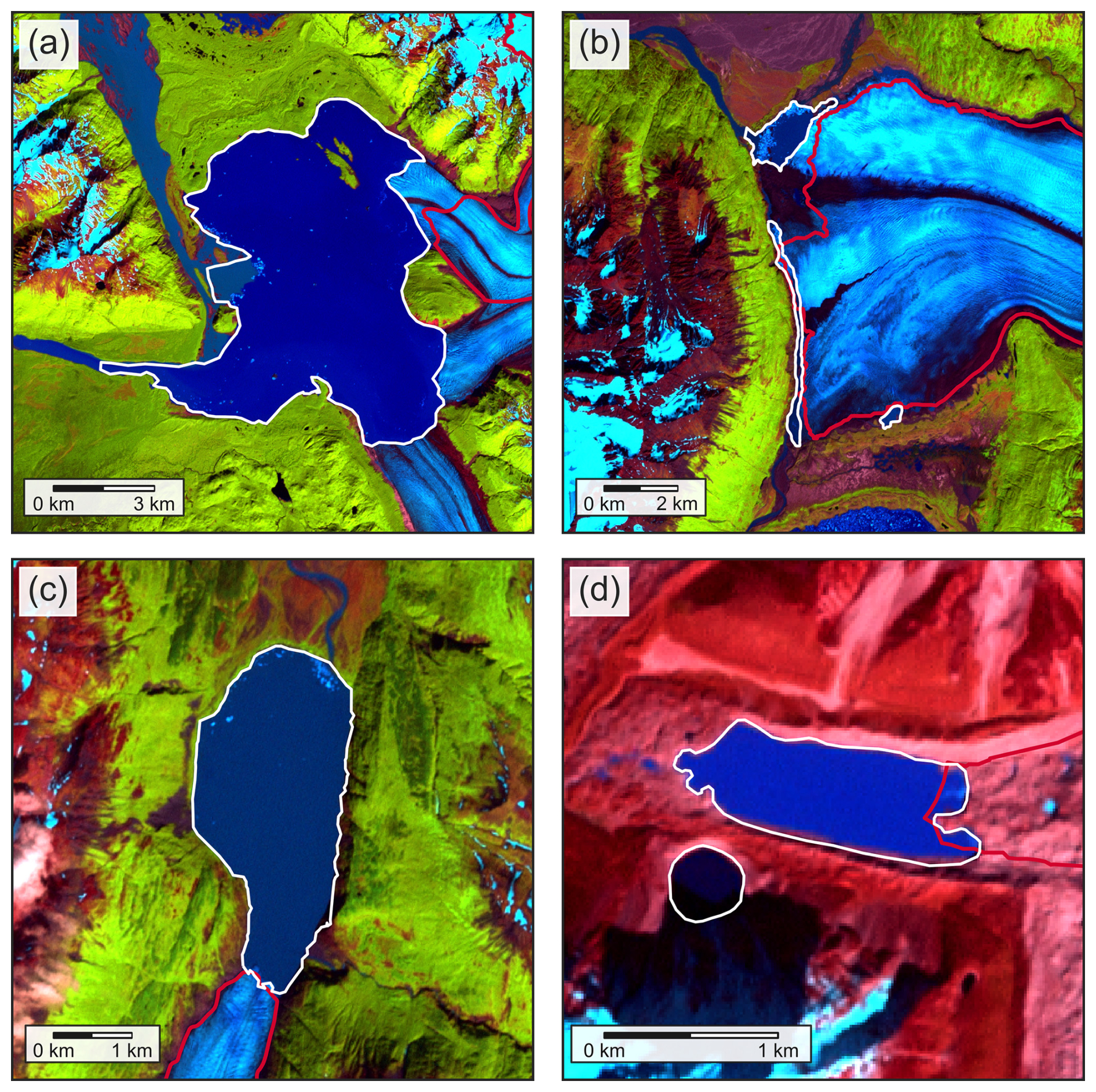
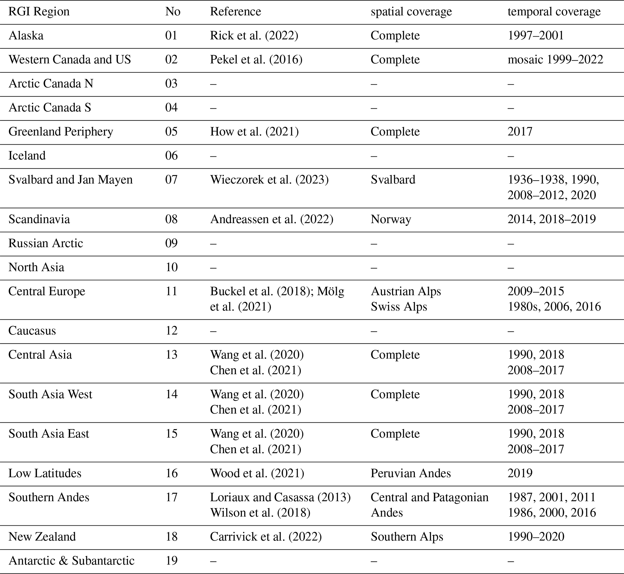
Figure 1Examples of lake-terminating Category 3 glacier termini. Background images are Landsat 7 ETM+ false-color composites (bands 5, 4, 3). RGI 7.0 outlines are shown in red, while lake outlines are shown in white. (a) Alsek Glacier (RGI2000-v7.0-G-01-16980) in Alaska (region 01). Landsat image acquired 10 August 2000. (b) Knik Glacier (RGI2000-v7.0-G-01-10684) in Alaska (region 01). Landsat image acquired 31 July 1999. (c) Skilak Glacier (RGI2000-v7.0-G-01-08014) in Alaska (region 01). Landsat image acquired 9 August 2000. (d) Lhotse Shar Glacier (RGI2000-v7.0-G-15-06763) in South Asia East (region 15). Landsat image acquired 30 October 2000.
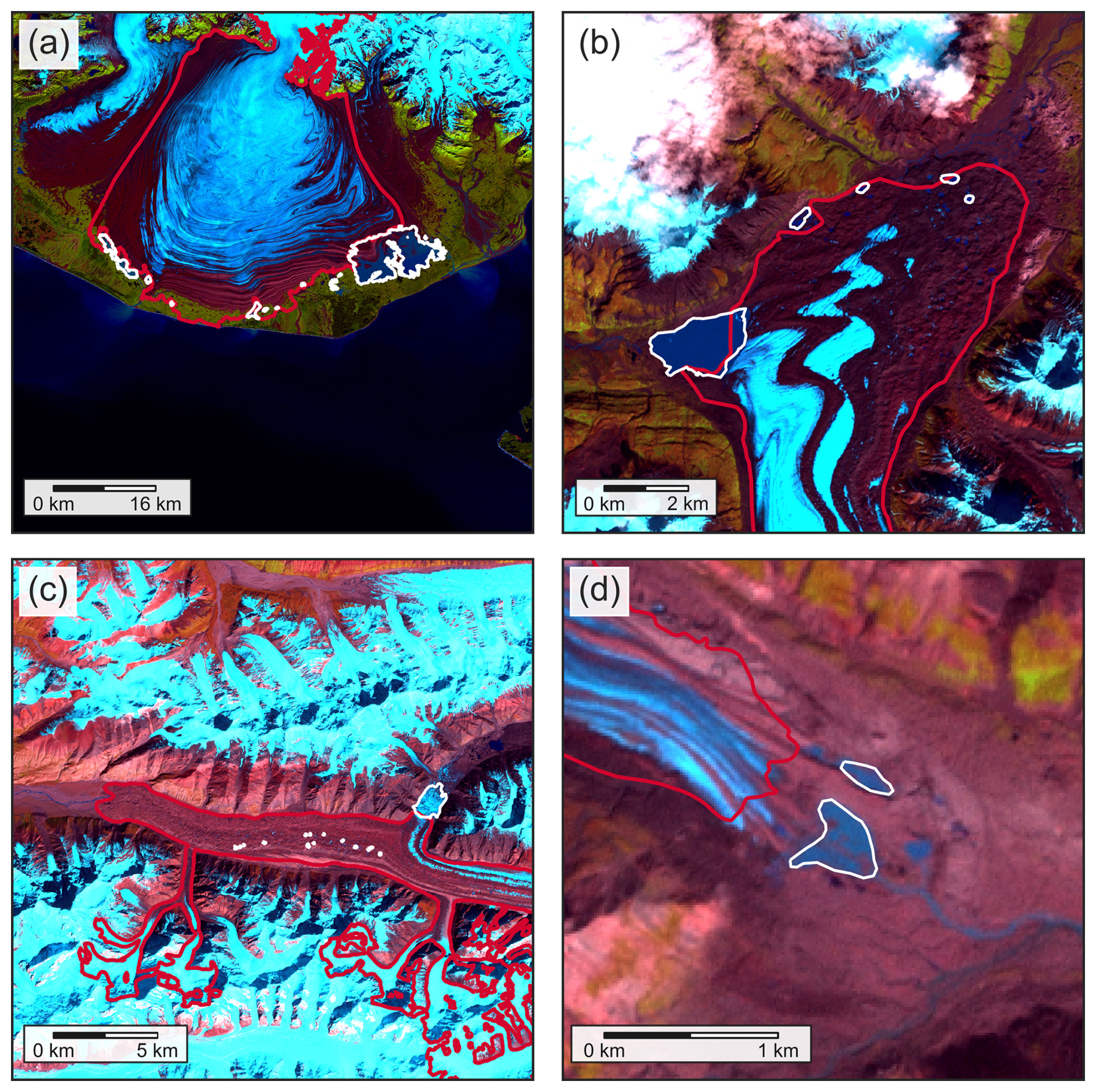
Figure 2Examples of lake-terminating Category 2 glacier termini. Background images are Landsat 7 ETM+ false-color composites (bands 5, 4, 3). RGI 7.0 outlines are shown in red, while lake outlines are shown in white. (a) Malaspina (Sít' Tlein) Glacier (RGI2000-v7.0-G-01-15261) in Alaska (region 01). Landsat image acquired 9 September 2000. (b) Russell Glacier (RGI2000-v7.0-G-01-16437) in Alaska (region 01). Landsat image acquired 31 August 2000. (c) Inilchek Glacier (RGI2000-v7.0-G-13-28434) in Central Asia (region 13). Landsat image acquired 13 September 2000. The main (largest) lake is not included in the regional lake inventory but is visible in satellite imagery (and is a known lake that is present most of the time but repeatedly drains as a glacial lake outburst flood). (d) Middle Fork Glacier (RGI2000-v7.0-G-01-06125) in Alaska (region 01). Landsat image acquired 11 August 1999.
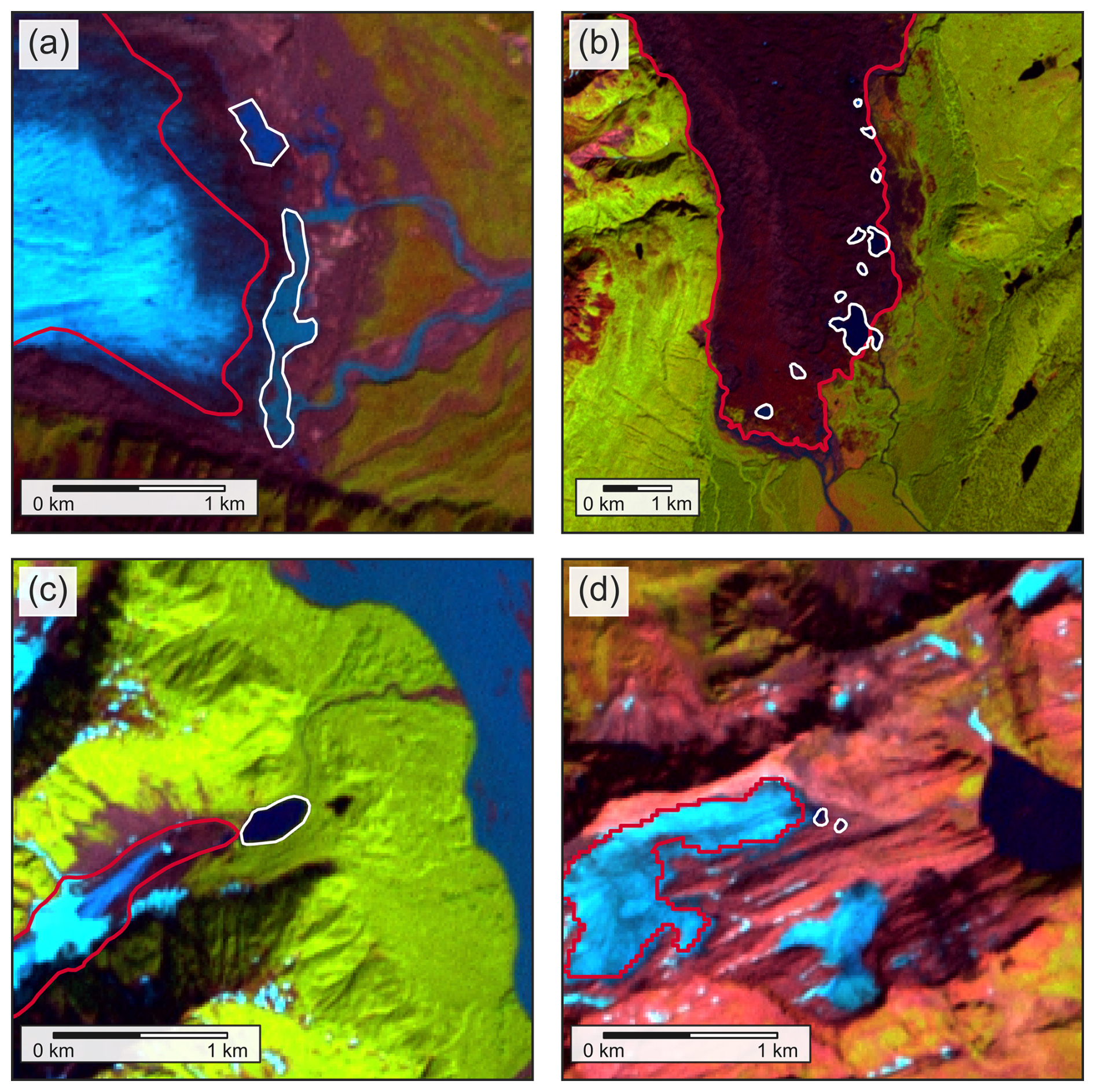
Figure 3Examples of lake-terminating Category 1 glacier termini. Background images are Landsat 7 ETM+ false-color composites (bands 5, 4, 3). RGI 7.0 outlines are shown in red, while lake outlines are shown in white. (a) Chisana Glacier (RGI2000-v7.0-G-01-05589) in Alaska (region 01). Landsat image acquired 11 August 1999. (b) Unnamed glacier (RGI2000-v7.0-G-01-04360) in Alaska (region 01). Landsat image acquired 16 August 2000. (c) Unnamed glacier (RGI2000-v7.0-G-01-16871) in Alaska (region 01). Landsat image acquired 10 August 2000. (d) Ghiaccio del Cavagn (RGI2000-v7.0-G-11-02473) in Central Europe (region 11). Landsat image acquired 28 August 2000.
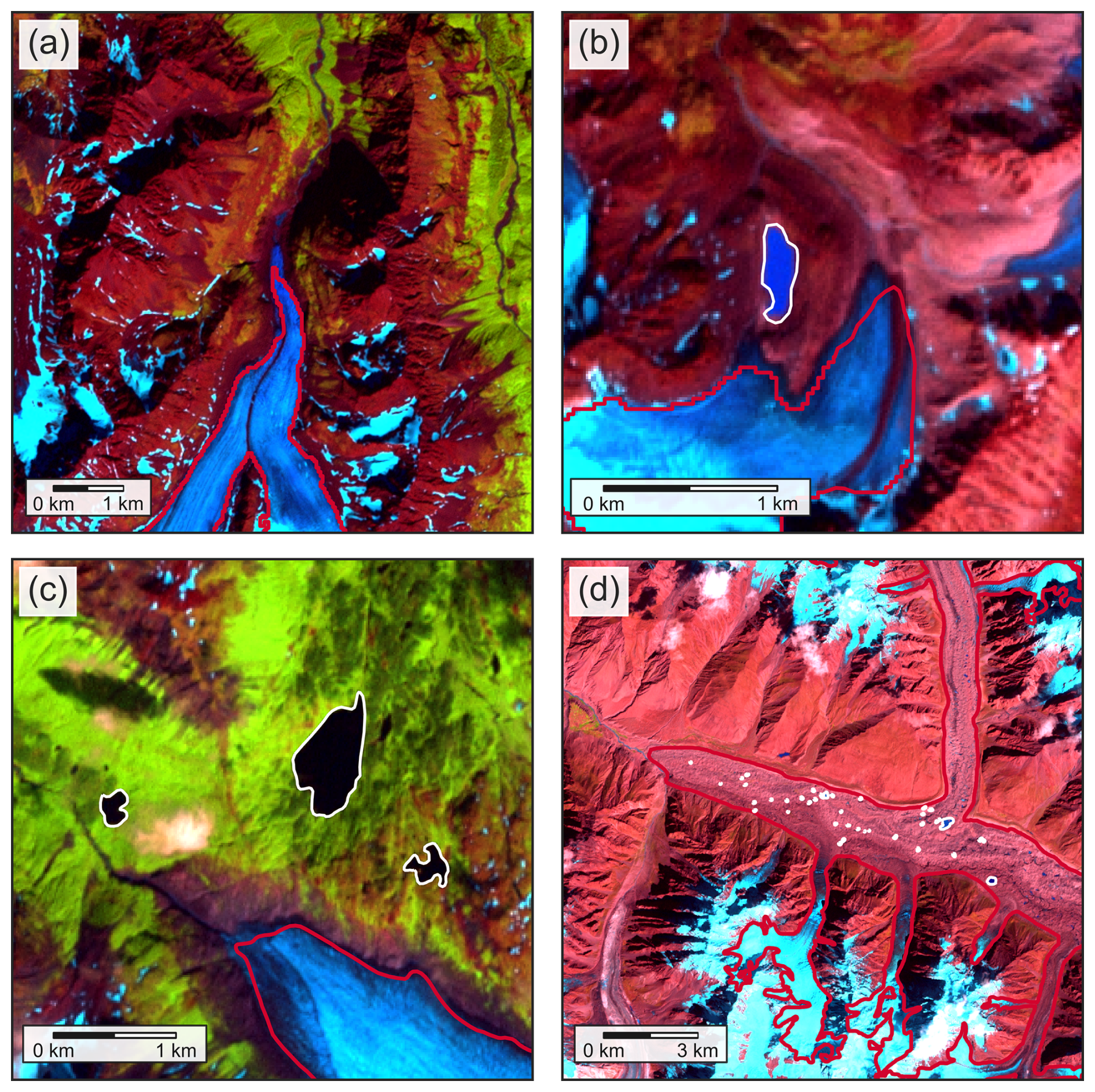
Figure 4Examples of lake-terminating Category 0 glacier termini. Background images are Landsat 7 ETM+ false-color composites (bands 5, 4, 3). RGI 7.0 outlines are shown in red, while lake outlines are shown in white. (a) Eklutna Glacier (RGI2000-v7.0-G-01-10928) in Alaska. Landsat image acquired 31 July 1999. (b) Unnamed glacier (RGI2000-v7.0-G-01-11048) in Alaska (region 01). Landsat image acquired 31 July 1999. (c) Harris Glacier (RGI2000-v7.0-G-01-08628) in Alaska (region 01). Landsat image acquired 9 August 2000. (d) Hispar Glacier, with numerous supraglacial ponds (RGI2000-v7.0-G-14-21670) in South Asia West (region 14). Landsat image acquired 11 September 2000.
These criteria require a proper identification of the glacier terminus from the entire glacier outline. For unclear termini found at ice caps and downstream-branching glaciers, we found it necessary to develop a strategy to locate the relevant portion of the glacier edge for the lake category assessment. Although the terminus is defined as the lowest end of a glacier (Cogley et al., 2011), a single point alone may not adequately capture the actual terminus (or potentially multiple termini). Additionally to the automatic classification of the terminus area using the 1 km buffer, we identified the lowest end of a glacier based on topography and flow direction as evident from images. This task must rely on the contributor's best judgment on the perceived topography, but only by doing so can we locate the terminus region and apply the criteria for the lake category classification. While the vast majority of lake flagging considered only terminal lakes, in the Canadian Arctic (RGI regions 03–04), some ice-marginal lakes are not in the terminus zone but show visible influence on glacier dynamics at scale, such as extensive calving. In this case, we assigned the glacier as Category 1, indicating a land-terminating glacier with potential future development driven by lake-ice interactions.
Additionally, we considered streams cutting across termini as Category 2 where expert judgment considered them to have considerable impact on ice melt, a feature only encountered in Alaska. Supraglacial lakes (lakes forming entirely on top of glacier ice) were not considered unless they coalesced into large water bodies that span the majority of the terminus.
In four regions (03, Arctic Canada North; 07, Svalbard and Jan Mayen; 17, Southern Andes; 19, Subantarctic and Antarctic Islands), we identified previously unidentified marine-terminating glaciers in the course of identifying lake-terminating glaciers using available Landsat imagery. In two of these regions (03 and 19), we also identified glaciers terminating in landfast ice or ice shelves. In region 03, we did this identification using the available Landsat imagery. For region 19, we compared the term_type attributes from version 6.0 of the RGI, high resolution coastline polylines from the Scientific Committee on Antarctic Research Antarctic Digital Database (Gerrish et al., 2024), and available Landsat imagery. To keep these glaciers distinct and aid in using this dataset to update the attributes of later RGI releases, we assigned marine-terminating glaciers a lake_cat of 99, and shelf-terminating glaciers a lake_cat of 98. For the purposes of estimating the total number and area of lake-terminating glaciers in each region, we treat these as having a lake_cat of 0 (i.e., not lake-terminating).
We acknowledge that neither the RGI 7.0 nor any lake database is perfect, including the dataset presented here. Given the complexity of the glacier-lake interface and the quality of imagery available, there can be uncertainty when judging whether a lake is actually ice-adjacent at the time of the inventory or simply in very close proximity. While this is less relevant for questions of hydrology, or even the potential lake hazard, it is more relevant in considering the influence on ice dynamics and upstream glacier mass loss. Although a consistent qualification of (un-)certainty across multiple contributing experts remains challenging, future iterations of this dataset may consider including a separate attribute that lets contributors self-assess their certainty for individual cases. In total, 45 047 glaciers were mapped by more than one contributor, and for a total of 1041 glaciers more than one submission is available, which we used to assess the agreement of classification across contributors.
Including all lake category categories described above in this database, even those with lower lake categories, will support future efforts where lakes could expand as glaciers continue to retreat (e.g., Furian et al., 2021). Future versions of this database, especially when they target a different year, and with the availability of updated glacier outlines, will benefit from this classification as changes in the terminus position may change the lake properties and could alter the connection category.
The data are stored and published as a comma-separated variable (CSV) file for each region, following the structure indicated in Table 2. The fields of the CSV file include the RGI ID (rgi_id), the assigned lake category (lake_cat), the ID of the satellite image used (image_id) and its respective date (image_date), the DOI of the lake inventory (if used; inventory_doi), and an identifier for the contributor(s) who classified the glacier (contributor). This structure allows for the lake termini product to be integrated seamlessly when processing RGI data.
(Chen et al., 2021)Table 2Data structure of the lake-terminating glacier dataset. rgi_id refers to the RGI ID (str), lake_cat to the assigned terminus category (int, 0 to 3), image_id to the corresponding imagery used for verification (str, either an identifier for the Landsat scene or text describing where imagery otherwise came from), image_date to the date of the imagery used (str, YYYY-MM-DD), inventory_doi to DOI of the lake inventory if available (str) and contributor to the ID of the contributor of the submission (str).

Additionally, we have used this dataset to update the term_type attribute for RGI 7.0 as follows, for all glaciers where the term_type attribute was previously not assigned (term_type = 9). Glaciers classified as lake_cat 2 or 3 in this study are given a term_type value of 2 in RGI 7.0 (i.e., lake-terminating). Glaciers classified with lake_cat values of 0 or 1 are given a term_type value of 0 (i.e., land-terminating). Finally, any glaciers classified in this study as marine-terminating (lake_cat = 98) or shelf-terminating (lake_cat = 99) are given a term_type value of 1 (marine-terminating) or 3 (shelf-terminating), respectively.
Of the 274 531 RGI 7.0 glaciers, 1.4 % (3837) were found to be lake-terminating, with 1.0 % (2734) classified as category 3, and the remaining 0.4 % (1103) as category 2 (Table 3). 98.1 % (269 302) were not lake-terminating (category 0 for land-terminating cases, categories 98 and 99 for marine-terminating or shelf-terminating cases), with an additional 0.5 % (1392) identified as having small lakes near the terminus (category 1). In individual regions, category 3 glaciers make up more than 1.0 % of all glaciers in 9 of the 19 RGI regions, with a maximum of 3.9 % in region 8 (Scandinavia). The relevance of lake-terminating glaciers increases when considering the area of the respective glaciers. While non lake-terminating glaciers (categories 0 and 1) comprise the vast majority of global glaciers by number (98.6 %), they only make up 88.5 % of the total glacier area. In contrast, while Category 3 and 2 lake-terminating glaciers account for 1.4 % of glaciers by number, they comprise 11.5 % by area (Table 3), reaching more than 20 % in regions 6 (Iceland, 33.1 %) and 17 (Southern Andes, 41.8 %). This prevalence of lake termini on larger glaciers is apparent from their relative frequency by area (Fig. 5a), with the median size of all glaciers (0.17 km2, σ= 38.42 km2), considerably smaller than for those lake-terminating (0.96 km2, σ= 110.03 km2).
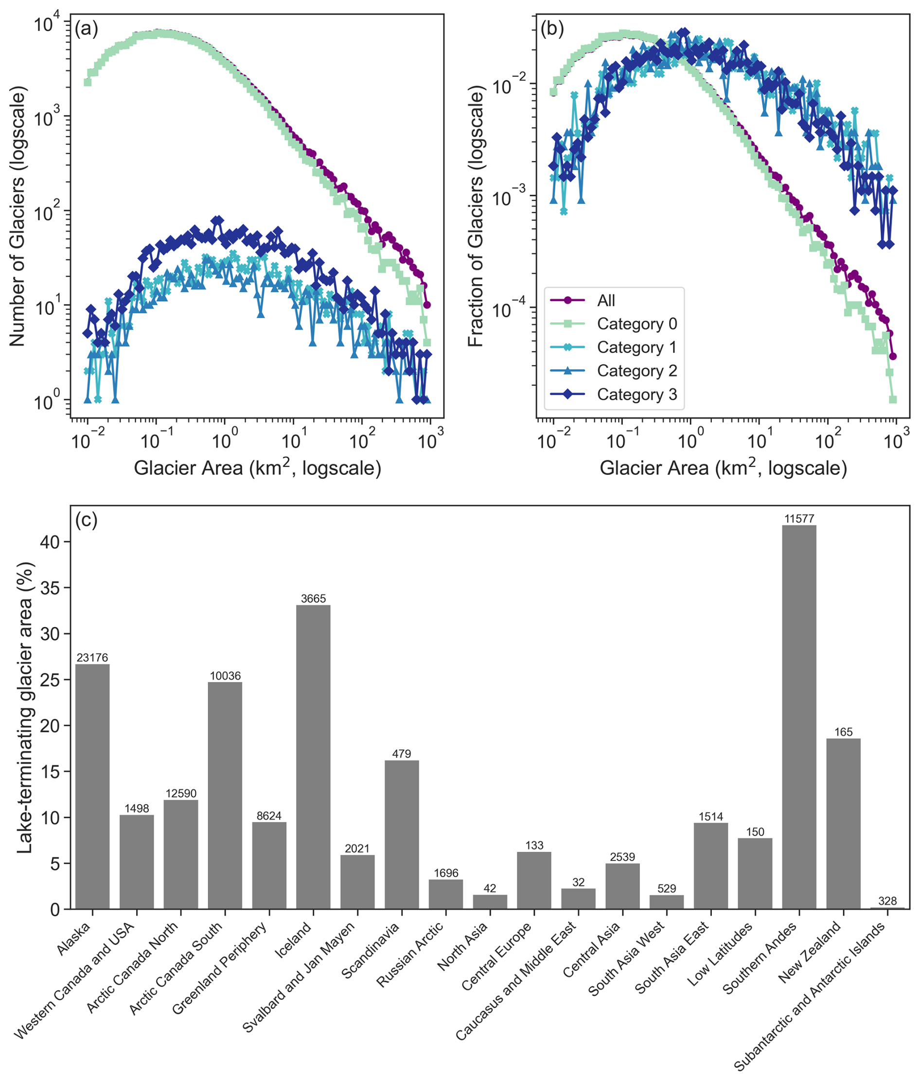
Figure 5(a) Number of glaciers per size category (log), for all glaciers in RGI 7.0, and for each lake-terminating category. (b) Fraction of glaciers per size category (log), for all glaciers in RGI 7.0, and for each lake-terminating category. (c) Relative area of lake-terminating glaciers (category 3 or 2) per RGI region. Bars are labeled with the total area (in km2) of lake-terminating glaciers for each region.
Table 3Number n, area A (in 1000 km2), and percent number/percent area for glaciers in each RGI region, by lake-terminating category. See Table 1 for region names and corresponding region number.
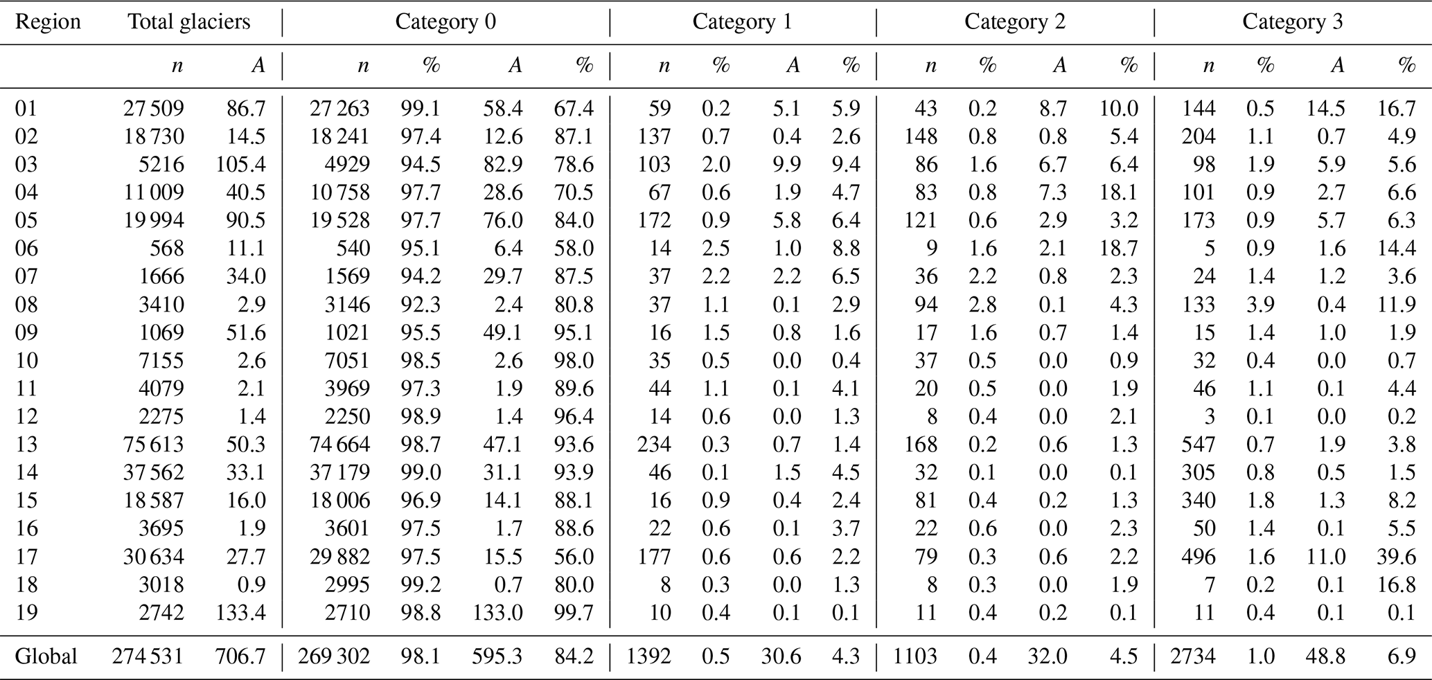
The difference between lake-terminating glacier number versus area becomes more apparent when comparing different regions (Table 3, Figs. 5 and 6). In the Russian Arctic (region 09), the Caucasus (region 12) and all three regions of High Mountain Asia (regions 13–15), both the relative number and area of glaciers with lake termini (Category 3 and 2) is below 5 %. In Alaska (region 01), Iceland (region 06) and the Southern Andes (region 17) on the other hand, the fraction of lake termini is low (0.7 %, 2.5 % and 1.9 %, respectively), but the associated glaciers respectively make up 26.7 %, 33.1 % and 41.8 % of the regional glacier area. These regions contain an abundance of large proglacial lakes, with Category 3 glaciers alone making up 16.7 %, 14.4 % and 39.6 % of the regional glacier area, respectively. In Scandinavia, 3.9 % of all glaciers have Category 3 termini (11.9 % by area). In Central Asia (region 13), South Asia West (region 14) and South Asia East (region 15), these relative numbers are much lower (0.7 %, 0.8 % and 1.8 %, respectively). In Central Asia and South Asia East, however, Category 3 lake-terminating glaciers still constitute 3.8 % and 8.2 % of the total area, while in South Asia West, their area is much smaller (1.5 %).
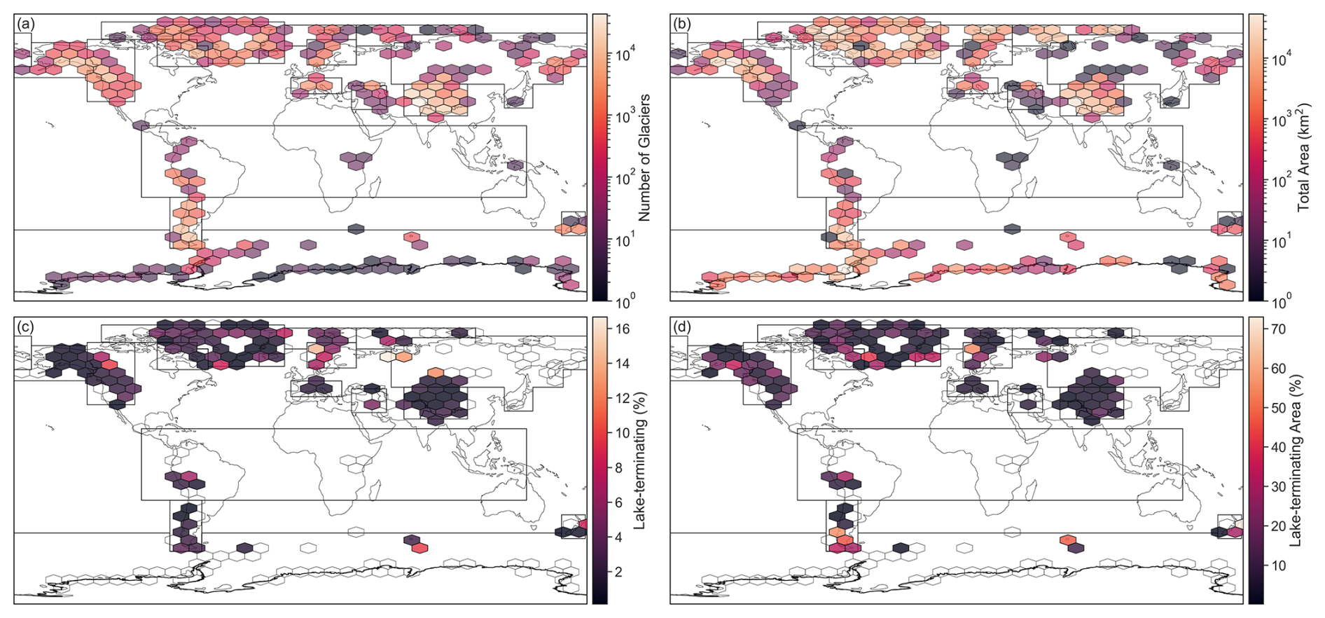
Figure 6Statistics aggregated to 10° hexagonal tiles. (a) Total number of glaciers according to RGI 7.0. (b) Total area of glaciers according to RGI 7.0 (km2). (c) Relative number of glacier termini classified as Category 3 and Category 2 (%). (d) Relative area of glaciers with termini classified as Category 3 and Category 2 (%).
Across RGI regions, “hotspots” of lake-terminating glaciers vary depending on the metric of interest. Considering the proportion of global lake-terminating glaciers by number, High Mountain Asia (regions 13–15) alone accounts for over one-third of the world's lake-terminating glaciers (Fig. 7a). The Southern Andes (region 17) are the next largest contributor at 15 %, with every other RGI region individually containing <10 % of the world's lake-terminating glaciers. Using the global proportion of lake-terminating glacier area as a metric produces an entirely different picture (Fig. 7b), with Alaska (region 01) alone accounting for ∼ 30 % of the world's lake-terminating glacier area. Arctic Canada (regions 03–04) holds another ∼ 30 %, the Southern Andes (region 17) hosts ∼ 15 %, and all other regions combined contain the remaining just over ∼ 25 % of global lake-terminating glacier area.
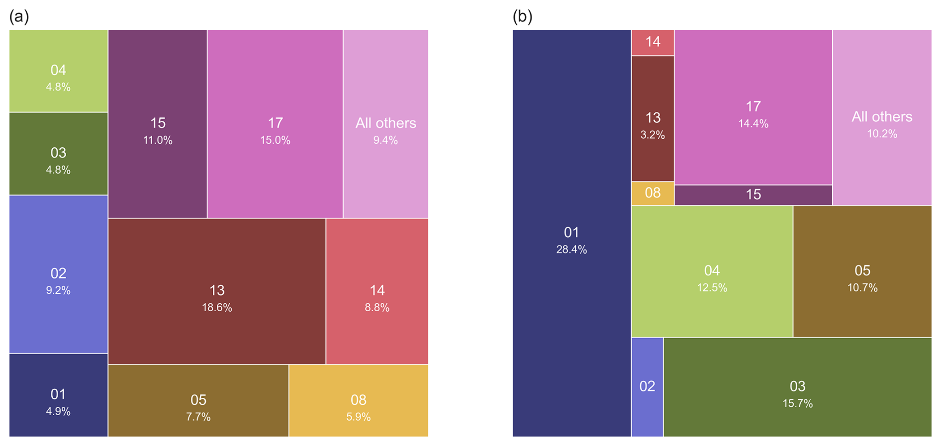
Figure 7Proportion of global lake-terminating glaciers in each RGI region, shown by (a) proportion of global number lake-terminating glaciers, and (b) proportion of global lake-terminating glacier area. RGI region numbers, with the percent attributable to that region shown within the chart. Lake-terminating glaciers are here defined as those with Category 3 or Category 2 termini. Regions with <2 % of the global total are combined into the “all others” category.
The prevalence of large lake-terminating glaciers in North America may in part reflect the region's geological setting and past glacial history resulting in glaciers that terminate in low sloping areas conducive to lake formation. Many large Alaska glaciers extend beyond the confines of bedrock constrained valleys to terminate in wide, relatively flat outwash plains that fill the deep troughs carved by Pleistocene glaciation (Péwé, 1975; Kaufman and Manley, 2004). In Arctic Canada, continental glaciation and limited tectonic activity for the past 30 Ma (Vamvaka et al., 2019) has resulted in low overall slope throughout the region. Low regional slope and large glacier area are both associated with the growth of proglacial lakes in Alaska (Field et al., 2021), potentially due to these quantities being associated with the more likely existence of large subglacial overdeepenings capable of hosting substantial proglacial lakes. In contrast, the high proportion of High Mountain Asia lake-terminating glaciers by number but small proportion by area may reflect the region's high average slope, less conducive to the formation of large proglacial lakes. In addition, the stability of the dam impounding the proglacial lake may partly explain regional variations in lake-terminating glacier abundance. The failure of a moraine dam impounding a proglacial lake is a common occurrence in High Mountain Asia, while it is rare in Alaska (Rick et al., 2023). The greater stability of moraine dams in Alaska, which again likely reflects the low average slope at glacier termini at regional scale, may allow for the persistence of terminal lakes that are less common in other regions.
While hazards associated with glacial lakes (i.e. glacial lake outburst floods) often occur from lakes without direct ice contact, hence making a much larger number of proglacial lakes potentially dangerous, drivers for outburst floods like glacier calving only play a role for glaciers with direct lake contact. Similarly, when considering the role of glacial lakes on ice dynamics, only ice contact lakes are relevant in potentially accelerating mass loss or increasing velocities. While earlier studies have focused on all potential proglacial lakes (between 14 394 (or 9414 for the 1990–1999 period, comparable to the time used for the inventory in this study, Shugar et al., 2020) and 71 505 (Zhang et al., 2024)), we find only 3837 glaciers that have direct lake contact. However, our inventory also suggests that the relative abundance of these proglacial lakes with direct ice contact varies widely between the different regions.
3.1 Mapping uncertainty
To evaluate the congruency of mapping for glacier as well as lake outlines, we extracted time stamps for images used to create RGI 7.0 outlines. We did the same for images used to check terminus type for lakes, which were reported for 75.49 % of all flags (Fig. 8). The average (±1σ) image year for RGI 7.0 is 2001 (±6.2), while for lake categories it was 2000 (±1.5). As we can assume that most lake termini have not changed significantly within this short period, this overlap was considered satisfactory.
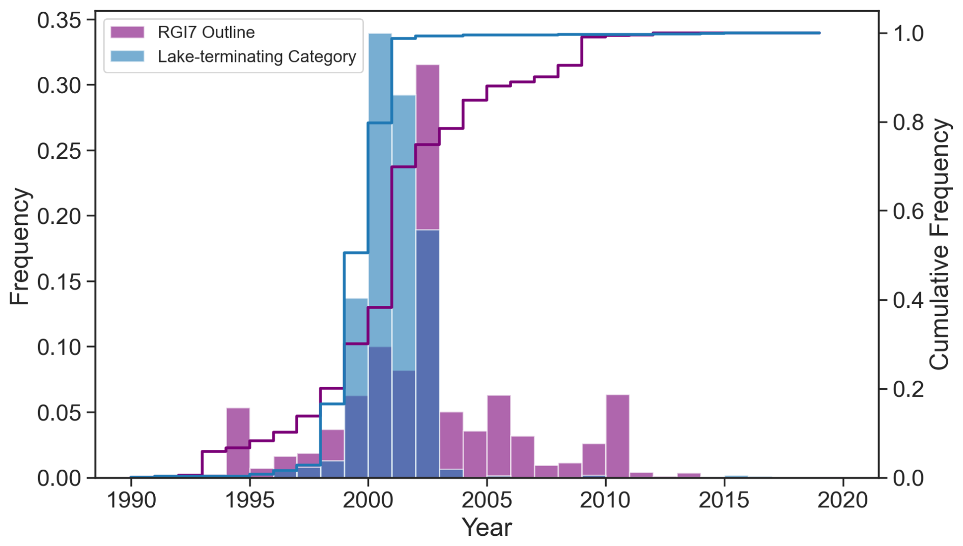
Figure 8Distribution of timestamp of imagery used to generate RGI 7.0 outlines and for classifying lake-terminating category.
Participants submitted their mapping in two ways: either individual files produced independently, or by compiling a consensus mapping for the region before submission. In total, 45 047 glaciers across seven regions were mapped by more than one participant (16 % of all glaciers). This was generally the case when one person did initial mapping and a second revised the judgment, without necessarily storing the original choice. For 1260 glaciers across eight regions, at least two separate submissions were available. Note that these duplicate submissions were not done with the primary intent to check consistency, but were sourced from all submissions, which suggests that the operators' attention to detail was no different from any other submission.
Of these 1260 cases where multiple lake category submissions were available, participants disagreed on the lake category classification for only 83 glaciers (6.7 %). As described in detail below, in only 14 of these 1260 cases (1.1 %) did a glacier originally identified as lake-terminating by one operator have its status changed to land-terminating after reviewing the conflict, suggesting the effort was consistent across operators. A confusion matrix of the disagreements is shown in Table 4. In the majority of cases (at least 72 out of 83, or 87 %), these disagreements were due in part to participants using different images for the classification. In most cases (44 out of 83, 53 %), the disagreement was between Category 0 and 1, which are both considered land-terminating. In 21 of these cases the final agreed category was 0, in 20 it was 1, and three times the reassessed category was Category 2. The decision of whether the glacier is in contact with one or more small lakes over a limited portion of the terminus (our definition for Category 1), or almost exclusively in contact with land (Category 0) is subjective. With a lack of precise and consistent lake outlines matching the time stamp of the glacier outlines, it remains difficult to tackle this issue with a consistent automatic approach (see Sect. 3.2). Such an effort could be the target of future work to refine this dataset.
Table 4Comparison of how operators disagreed for glaciers with mapping conflicts. The row and column headers indicate the assigned lake category.
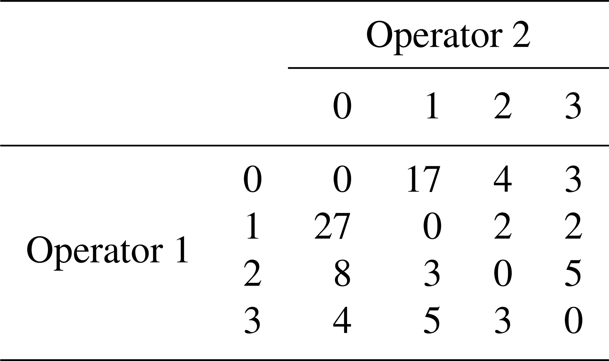
In 31 cases (37.4 %) there was disagreement between lake-terminating (Category 2 or 3) and land-terminating (Category 0 or 1), of which 14 were subsequently judged to be land-terminating and 17 lake-terminating. In 5 of these 31 cases, the disagreement was between category 2 and 1, which again provides opportunity for subjectivity as deciding whether the ice-lake interface spans more or less than 10 % of the terminus width can be difficult to quantify exactly. The remaining cases are largely subject to the different imagery used, and the quality of the ice-lake interface was considerably different or lakes had appeared between one or the other, potentially possible considering the time range of imagery used (Fig. 8). Often the disagreement was simply because of differing prioritization of glacier masks versus available imagery. Figure 9 shows two cases of Category 3 termini, where the RGI outlines alone do not suggest a clear interface with the present lake body (and were hence marked as Category 2 and 0, respectively, by different operators), while the imagery clearly suggests a substantial contact. Although in both of these cases the final category was stored as Category 3, it suggests that in cases where the outline does not clearly provide an overlap with the lake outline there may be more erroneous misclassifications.
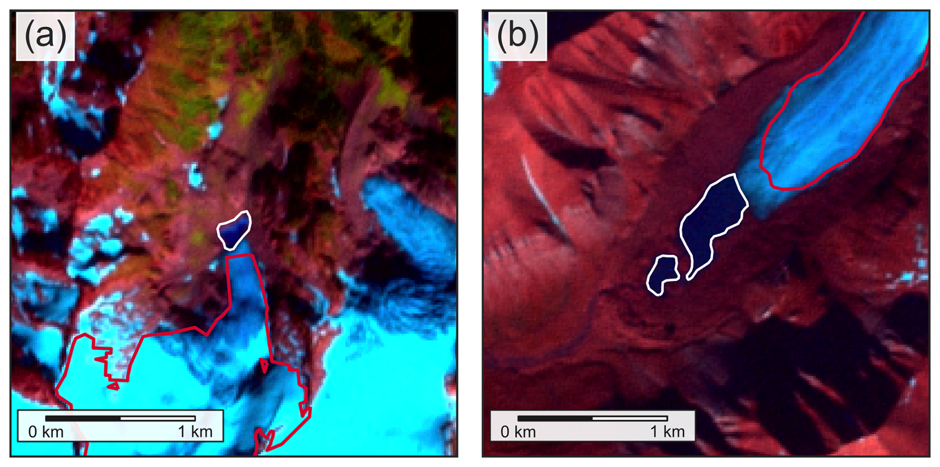
Figure 9Examples of glaciers where operators disagreed on lake categories for eventual lake-terminating Category 3 cases. RGI 7.0 outlines are shown in red, while lakes are shown in white. Background images are Landsat 7 ETM+ false-color composites (bands 5, 4, 3). (a) Shudder Glacier (RGI2000-v7.0-G-02-07418), mapped as both Category 3 and 2. Landsat image acquired 23 September 2000. (b) Ragnarbreen (RGI2000-v7.0-G-07-00470), mapped as both Category 3 and 0. Landsat image acquired 17 August 2000.
Where there was disagreement between participants over the classification for a glacier, the disagreement was resolved either by having a third person check the glacier and make a decision, or by having participants discuss and come to an agreement. We acknowledge that complete agreement is likely unattainable, as is the case for glacier outlines. We suggest, however, that future availability of consistent global lake inventories with a clear time stamp and based on high resolution imagery, will allow to further increase agreement on terminus type.
3.2 Comparison to global lake inventories
As an additional comparison, we used the automated approach described above (Sect. 2) to spatially join the buffered RGI 7.0 terminus locations with lakes from three global inventories (Shugar et al., 2020; Zhang et al., 2024; Song et al., 2025), using four different buffer sizes (0, 100, 500, and 1000 m). For the Shugar et al. (2020) inventory, we used lakes from 2000–2004; for Zhang et al. (2024), we used lakes from 1990; and for Song et al. (2025), we used all ice-contact and supraglacial lakes. For the purposes of this comparison, we assigned as lake-terminating all glaciers where the buffered terminus location intersected a lake.
Figure 10 shows the comparison of the manually identified lake-terminating glacier dataset produced by this study and the intersection of the buffered terminus location with the global lake inventories. Note that only Zhang et al. (2024) has a result for all RGI regions, as neither Shugar et al. (2020) nor Song et al. (2025) mapped regions 07 (Svalbard and Jan Mayen) or 19 (Antarctic and Subantarctic Islands) due to a comparative lack of cloud-free imagery.
On the regional scale, the different buffer sizes give regional percentages of lake-terminating glaciers down to 30 %, compared to the maximum. On the global scale, numbers of lake-terminating glaciers calculated by each inventory numbers between n=823 (Shugar et al., 2020, using a 0 m buffer) and n=32 405 (Zhang et al., 2024, using a 1000 m buffer). The wide range in the number of lake-terminating glaciers identified using each global inventory highlights the challenge in using an automated approach at the global scale using the currently available datasets.
The “best” choice of buffer for each inventory, as determined by the minimum absolute difference between the number of glaciers with a lake intersecting the buffered terminus location and the number of lake-terminating glaciers determined manually, varies by region for each lake inventory. For Shugar et al. (2020), the 500 m buffer produced the best agreement in 8 regions, while the 100 m buffer worked best in 6 regions. For the Zhang et al. (2024) inventory, the 100 m buffer worked best in 14 of 19 regions, while the 0 m buffer worked best for the Song et al. (2025) inventory.
While the Shugar et al. (2020) lake inventory largely matches temporally with the RGI outlines (ca. 2001 ± 6.2 years), there is a large temporal difference between the RGI outlines and the other two inventories we have used. While Song et al. (2025) do not report a date for their lake inventory, their dataset represents the maximum extent of individual lakes over the period 1984–2020. Because of this temporal discrepancy, we would not expect to see exact agreement with the manually identified lake-terminating glaciers. Additionally, the definition we use for Category 2 or 3 is not the same as “lake intersects a buffer around the terminus location”. Because of this, the number of glaciers identified using each global lake inventory are most often an overestimation, as falling within a buffer does not automatically imply substantial contact between the lake and the glacier terminus. In fact, for all inventories and all regions, the 1000 m buffer provided the best rate of agreement with the manual classification (glaciers identified as lake-terminating through both approaches), but this also came with a much higher rate of false positives (glaciers identified as lake-terminating from the spatial join but not from the manual identification). This increased rate of false positives, coupled with the difficulty in automatically identifying the terminus region from the RGI outline alone, demonstrates the need for manual checking.
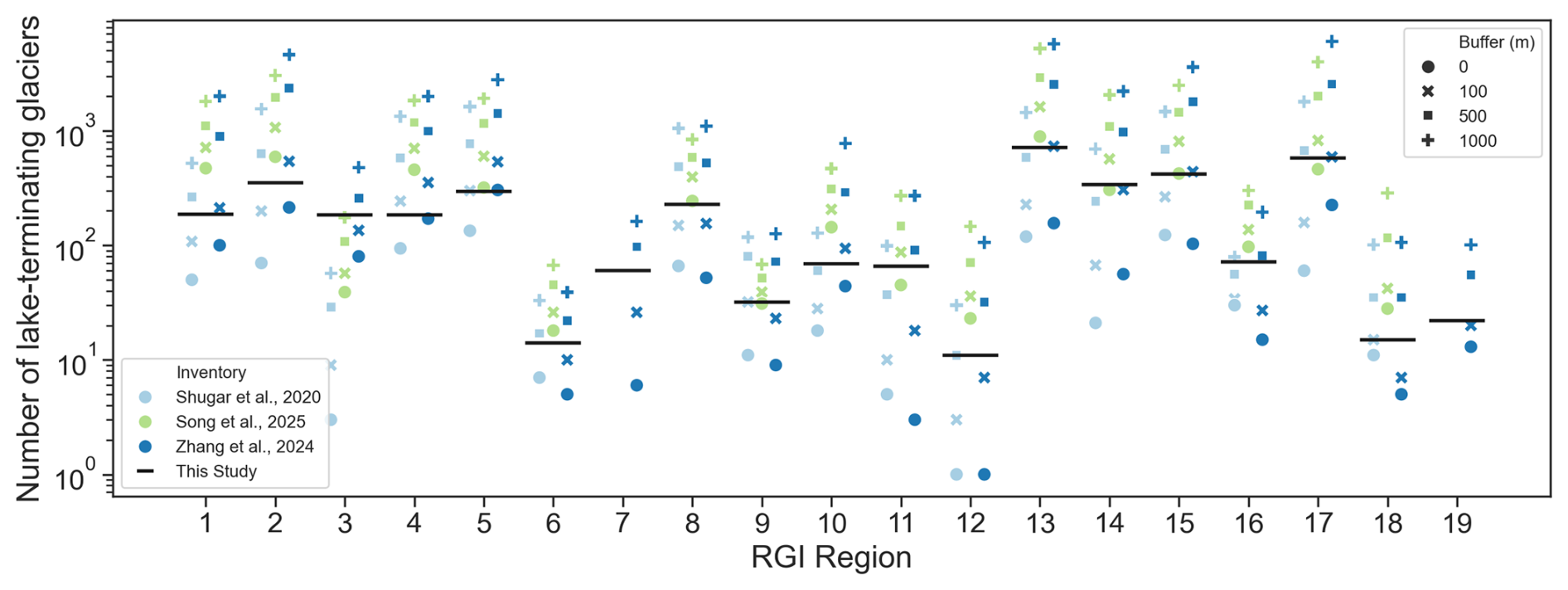
Figure 10Comparison of the number of lake-terminating glaciers for each RGI region identified using three global lake inventories (Shugar et al., 2020; Zhang et al., 2024; Song et al., 2025) with a variable buffer around the RGI 7.0 terminus location. Black lines indicate the number of lake-terminating glaciers identified as part of the current study.
The data generated for this study are available at https://doi.org/10.5281/zenodo.15524733 (Steiner et al., 2025). The data include all material documenting the process described in this manuscript. The final dataset produced is stored in the dataset folder, which contains the following sub-folders: contributor_files/, csv/, lakeflags/, and outlines/. The final .csv files for each RGI region are in the csv/ folder, while lakeflags/ contains geopackage (.gpkg) files for each region, with the lake-terminating category tables joined to the RGI 7.0 centroid for each glacier. The outlines/ folder contains .gpkg files with RGI 7.0 outlines for all glaciers with a lake-terminating category of 1, 2, or 3. The original files submitted by contributors are found in the contributor_files/ folder, organized into sub-folders for each RGI region where more than one file was submitted.
The dataset/ folder also includes files that contain the contributor names and IDs (contributors.csv), the number of glaciers that have been mapped by multiple operators per region (multiple_operators.csv) and a summary of glaciers where conflicts arose (mappingconflicts.csv).
The dataset can also be accessed at https://github.com/GLIMS-RGI/lake_terminating (last access: 2 February 2026). The scripts used to produce the figures and tables in this manuscript are available at https://doi.org/10.5281/zenodo.15524733 (Steiner et al., 2025). The data will also be integrated into the forthcoming RGI update, v7.1.
The importance of proglacial lakes is often noted across many glacierized mountain regions, whether it is for their potential to influence glacier dynamics, glacier mass loss, or their role in cryospheric hazards. While glacial lakes without a direct ice-water interface can potentially play an important role in mountain hydrology and limnology and as a source of glacial lake outburst floods, direct contact is necessary for the lake to have any potential influence on glacier dynamics and mass loss. In this study, we, for the first time, quantify the total number of glaciers in direct contact with a lake (3837, 1.4 % of all glaciers in RGI 7.0) as well as those that may influence dynamics, albeit with a less extensive ice-water interface (2734, 1 %). While these numbers are relatively low at the global scale, they rise up to 6.9 % and 3.9 %, respectively, in individual regions. Glaciers with adjacent lakes tend to be larger, with glaciers with lake termini making up 11.4 % of the total glacier cover, and 6.9 % of glaciers identified as Category 3.
Mapping exercises like the one conducted here are always subject to errors as well as some level of subjectivity when judging the role lakes may play at the glacier terminus. Relying on 1260 glaciers, where at least two individual operators independently flagged the termini, we can show that only for 6.7 % of all glaciers conflicts in judgment occurred. For 50 % of these conflicts the disagreement was over different categories of land-terminating glaciers (i.e. Category 0 and 1). The remaining disagreements suggest a relatively small margin of error in the dataset to correctly identify lake termini, largely subject to different imagery chosen for the analysis or the glacier masks being used as defining over underlying imagery.
We suggest that the relative importance of proglacial lakes should be further investigated, taking into account both these regional variations as well as the relative fraction by number and area. The prevalence of proglacial lakes has previously been identified as a cause for accelerated mass loss in the Himalaya (King et al., 2019) and Patagonia (Minowa et al., 2021). In combination with spatially distributed mass loss data, the dataset presented here can provide the baseline to effectively investigate to what degree this is the case for other regions or at the global scale.
The present analysis does not consider the actual number of lakes in contact with an individual glacier or the length of the ice-water interface, remaining a task for future analysis. Furthermore, the inventory only considers the time around the year 2000 (±1.5), to align with the available global glacier inventory (RGI 7.0) and could potentially be updated as updated glacier outlines become available. Modelling studies considering later time steps should use caution applying this dataset, considering the rapidly changing nature of lakes and their interfaces with glacier ice.
Future studies could use this inventory as an initial state to evaluate the changing nature of termini with adjacent lakes. Investigations into the role of the presence or absence of a proglacial lake on mass loss and ice dynamics is now possible at the global scale. This would improve our understanding of the relative importance of change along the ice-water interface, irrespective of the growing number of glacial lakes. The dataset will also allow for the scaling of in-situ insights on specific processes like calving or temperature and turbidity gradients, and could provide a baseline for investigations into the risk of outburst floods from proglacial lakes with and without ice-water interfaces.
FM initiated the study, RA, WA, TB, WK, RM and JS conceptualized the study and coordinated the mapping effort. JS led the writing and JS and RM did analysis, RM created figures with input from JS, RA, WA and TB. All others contributed by flagging individual termini in one or more regions as well as with reviewing the manuscript.
The contact author has declared that none of the authors has any competing interests.
Publisher's note: Copernicus Publications remains neutral with regard to jurisdictional claims made in the text, published maps, institutional affiliations, or any other geographical representation in this paper. The authors bear the ultimate responsibility for providing appropriate place names. Views expressed in the text are those of the authors and do not necessarily reflect the views of the publisher.
The authors thank Alexandre Bevington and Matt Nolan for supporting the study with satellite imagery and known lake locations. We thank Regine Hock for comments on presentation of this work that informed the text. The authors thank Penny How, Johnny Ryan, and an anonymous reviewer for constructive reviews that considerably improved both the manuscript and the dataset.
Levan Tielidze was supported by the Australian Research Council (ARC) Special Research Initiative (SRI) Securing Antarctica's Environmental Future (grant no. SR200100005). William Armstrong was supported by US NSF 2334775. Tobias Bolch was supported by ESA within the Dragon 6 project (grant no. 4000148860/25/I-LG-bgh). Brian Menounos was supported by the Natural Sciences and Engineering Research Council of Canada and Tula Foundation. This research has been supported by the University of Graz.
This paper was edited by Kang Yang and reviewed by Penelope How, Jonathan Ryan, and one anonymous referee.
Andreassen, L. M., Nagy, T., Kjøllmoen, B., and Leigh, J. R.: An inventory of Norway's glaciers and ice-marginal lakes from 2018–19 Sentinel-2 data, Journal of Glaciology, 68, 1085–1106, https://doi.org/10.1017/jog.2022.20, 2022. a
Baurley, N. R., Robson, B. A., and Hart, J. K.: Long-term impact of the proglacial lake Jökulsárlón on the flow velocity and stability of Breiðamerkurjökull glacier, Iceland, Earth Surface Processes and Landforms, 45, 2647–2663, https://doi.org/10.1002/esp.4920, 2020. a
Boyce, E. S., Motyka, R. J., and Truffer, M.: Flotation and retreat of a lake-calving terminus, Mendenhall Glacier, southeast Alaska, USA, Journal of Glaciology, 53, 211–224, https://doi.org/10.3189/172756507782202928, 2007. a
Buckel, J., Otto, J. C., Prasicek, G., and Keuschnig, M.: Glacial lakes in Austria – Distribution and formation since the Little Ice Age, Global and Planetary Change, 164, 39–51, https://doi.org/10.1016/j.gloplacha.2018.03.003, 2018. a
Carrivick, J. L., Sutherland, J. L., Huss, M., Purdie, H., Stringer, C. D., Grimes, M., James, W. H. M., and Lorrey, A. M.: Coincident evolution of glaciers and ice-marginal proglacial lakes across the Southern Alps, New Zealand: Past, present and future, Global and Planetary Change, 211, 103792, https://doi.org/10.1016/j.gloplacha.2022.103792, 2022. a
Chen, F., Zhang, M., Guo, H., Allen, S., Kargel, J. S., Haritashya, U. K., and Watson, C. S.: Annual 30 m dataset for glacial lakes in High Mountain Asia from 2008 to 2017, Earth System Science Data, 13, 741–766, https://doi.org/10.5194/essd-13-741-2021, 2021. a, b, c, d, e
Cogley, J. G., Hock, R., Rasmussen, L. A., Arendt, A. A., Bauder, A., Braithwaite, R. J., Jansson, P., Kaser, G., Möller, M., Nicholson, L., and Zemp, M.: Glossary of Glacier Mass Balance and Related Terms, in: IHP-VII Technical Documents in Hydrology No. 86, IACS Contribution No. 2, UNESCO-IHP, Paris, https://wgms.ch/downloads/Cogley_etal_2011.pdf (last access: 2 Feburay 2026), 2011. a
Dye, A., Bryant , R., Falcini, F., Mallalieu, J., Dimbleby, M., Beckwith, M., Rippin, D., and Kirchner, N.: Warm proglacial lake temperatures and thermal undercutting enhance rapid retreat of an Arctic glacier, The Cryosphere, 19, 4471–4486, https://doi.org/10.5194/tc-19-4471-2025, 2025. a
Field, H. R., Armstrong, W. H., and Huss, M.: Gulf of Alaska ice-marginal lake area change over the Landsat record and potential physical controls, The Cryosphere, 15, 3255–3278, https://doi.org/10.5194/tc-15-3255-2021, 2021. a
Furian, W., Loibl, D., and Schneider, C.: Future glacial lakes in High Mountain Asia: An inventory and assessment of hazard potential from surrounding slopes, Journal of Glaciology, https://doi.org/10.1017/jog.2021.18, 2021. a
Gerrish, L., Ireland, L., Fretwell, P., and Cooper, P.: High resolution vector polylines of the Antarctic coastline (7.9), UK Polar Data Centre, Natural Environment Research Council, UK Research & Innovation [data set], https://doi.org/10.5285/45C3CC90-098B-45E3-A809-16B80EED4EC2, 2024. a
How, P., Messerli, A., Mätzler, E., Santoro, M., Wiesmann, A., Caduff, R., Langley, K., Bojesen, M. H., Paul, F., Kääb, A., and Carrivick, J. L.: Greenland-wide inventory of ice marginal lakes using a multi-method approach, Scientific Reports, 11, 4481, https://doi.org/10.1038/s41598-021-83509-1, 2021. a, b
Kaufman, D. S. and Manley, W. F.: Pleistocene Maximum and Late Wisconsinan glacier extents across Alaska, USA, in: Developments in Quaternary Sciences, vol. 2, Elsevier, 9–27, ISBN 978-0-444-51592-6, https://doi.org/10.1016/S1571-0866(04)80182-9, 2004. a
King, O., Bhattacharya, A., Bhambri, R., and Bolch, T.: Glacial lakes exacerbate Himalayan glacier mass loss, Scientific Reports, 9, 18145, https://doi.org/10.1038/s41598-019-53733-x, 2019. a, b
Larsen, C. F., Burgess, E. W., Arendt, A. A., O'Neel, S., Johnson, A. J., and Kienholz, C.: Surface melt dominates Alaska glacier mass balance, Geophysical Research Letters, 42, 5902–5908, https://doi.org/10.1002/2015GL064349, 2015. a
Loriaux, T. and Casassa, G.: Evolution of glacial lakes from the Northern Patagonia Icefield and terrestrial water storage in a sea-level rise context, Global and Planetary Change, 102, 33–40, https://doi.org/10.1016/j.gloplacha.2012.12.012, 2013. a
Main, B., Copland, L., Smeda, B., Kochtitzky, W., Samsonov, S., Dudley, J., Skidmore, M., Dow, C., Wychen, W. V., Medrzycka, D., Higgs, E., and Mingo, L.: Terminus change of Kaskawulsh Glacier, Yukon, under a warming climate: retreat, thinning, slowdown and modified proglacial lake geometry, Journal of Glaciology, 69, 936–952, https://doi.org/10.1017/jog.2022.114, 2023. a
Minowa, M., Schaefer, M., Sugiyama, S., Sakakibara, D., and Skvarca, P.: Frontal ablation and mass loss of the Patagonian icefields, Earth and Planetary Science Letters, 561, 116811, https://doi.org/10.1016/j.epsl.2021.116811, 2021. a, b
Minowa, M., Schaefer, M., and Skvarca, P.: Effects of topography on dynamics and mass loss of lake-terminating glaciers in southern Patagonia, Journal of Glaciology, 69, 1580–1597, https://doi.org/10.1017/jog.2023.42, 2023. a
Mölg, N., Huggel, C., Herold, T., Storck, F., Allen, S., Haeberli, W., Schaub, Y., and Odermatt, D.: Inventory and evolution of glacial lakes since the Little Ice Age: Lessons from the case of Switzerland, Earth Surface Processes and Landforms, 46, 2551–2564, 2021. a, b
Pekel, J.-F., Cottam, A., Gorelick, N., and Belward, A. S.: High-resolution mapping of global surface water and its long-term changes, Nature, 540, 418–422, https://doi.org/10.1038/nature20584, 2016. a
Péwé, T. L.: Quaternary geology of Alaska, USGS Professional Paper 835, US Government Printing Office, Washington DC, https://doi.org/10.3133/pp835, 1975. a
Pratap, B., Oulkar, S. N., Garg, P. K., Sharma, P., and Thamban, M.: Mass balance of lake terminating Gepang Gath glacier (western Himalaya, India) and the role of glacier–lake interactions, Journal of Glaciology, 71, e30, https://doi.org/10.1017/jog.2025.31, 2025. a
Pronk, J. B., Bolch, T., King, O., Wouters, B., and Benn, D. I.: Contrasting surface velocities between lake- and land-terminating glaciers in the Himalayan region, The Cryosphere, 15, 5577–5599, https://doi.org/10.5194/tc-15-5577-2021, 2021. a
RGI Consortium: Randolph Glacier Inventory - A Dataset of Global Glacier Outlines (NSIDC-0770, Version 7), Boulder, Colorado USA, National Snow and Ice Data Center [data set], https://doi.org/10.5067/F6JMOVY5NAVZ, 2023. a
Rick, B., McGrath, D., Armstrong, W., and McCoy, S. W.: Dam type and lake location characterize ice-marginal lake area change in Alaska and NW Canada between 1984 and 2019, The Cryosphere, 16, 297–314, https://doi.org/10.5194/tc-16-297-2022, 2022. a, b
Rick, B., McGrath, D., McCoy, S. W., and Armstrong, W. H.: Unchanged frequency and decreasing magnitude of outbursts from ice-dammed lakes in Alaska, Nature Communications, 14, 6138, https://doi.org/10.1038/s41467-023-41794-6, 2023. a
Röhl, K.: Thermal regime of an ice-contact lake and its implication for glacier retreat, in: Ice in the Environment. Proceedings of the 16th IAHR International Symposium on Ice, International Asociation for Hydraulic Research, Dunedin, 304–312, ISBN 1-877139-52-1, 2003. a
Röhl, K.: Thermo-erosional notch development at fresh-water-calving Tasman Glacier, New Zealand, Journal of Glaciology, 52, 203–213, https://doi.org/10.3189/172756506781828773, 2006. a
Shugar, D. H., Burr, A., Haritashya, U. K., Kargel, J. S., Watson, C. S., Kennedy, M. C., Bevington, A. R., Betts, R. A., Harrison, S., and Strattman, K.: Rapid worldwide growth of glacial lakes since 1990, Nature Climate Change, https://doi.org/10.1038/s41558-020-0855-4, 2020. a, b, c, d, e, f, g, h, i, j, k
Song, C., Fan, C., Ma, J., Zhan, P., and Deng, X.: A spatially constrained remote sensing-based inventory of glacial lakes worldwide, Scientific Data, 12, 464, https://doi.org/10.1038/s41597-025-04809-z, 2025. a, b, c, d, e, f, g
Steiner, J., Armstrong, W., Kochtitzky, W., McNabb, R., Aguayo, R., Bolch, T., Maussion, F., Agarwal, V., Barr, I., Cloutier, M., DeWater, K., Donachie, F., Drocourt, Y., Garg, S., Joshi, G., Guzman, B., Kutuzov, S., Loriaux, T., Mathias, C., Menounos, B., Miles, E., Osika, A., Potter, K., Racoviteanu, A., Rick, B., Sterner, M., Tallentire, G., Tielidze, L., White, R., Wu, K., and Zheng, W.: GLIMS-RGI Lake-terminating glaciers: v1.0-subm, Zenodo [data set], https://doi.org/10.5281/zenodo.15524734, 2025. a, b, c
Sugiyama, S., Minowa, M., Sakakibara, D., Skvarca, P., Sawagaki, T., Ohashi, Y., Naito, N., and Chikita, K.: Thermal structure of proglacial lakes in Patagonia, Journal of Geophysical Research: Earth Surface, 121, 2270–2286, https://doi.org/10.1002/2016JF004084, 2016. a
Sugiyama, S., Minowa, M., Fukamachi, Y., Hata, S., Yamamoto, Y., Sauter, T., Schneider, C., and Schaefer, M.: Subglacial discharge controls seasonal variations in the thermal structure of a glacial lake in Patagonia, Nature Communications, 12, 6301, https://doi.org/10.1038/s41467-021-26578-0, 2021. a
Sutherland, J. L., Carrivick, J. L., Gandy, N., Shulmeister, J., Quincey, D. J., and Cornford, S. L.: Proglacial lakes control glacier geometry and behavior during recession, Geophysical Research Letters, https://doi.org/10.1029/2020gl088865, 2020. a
Trüssel, B. L., Motyka, R. J., Truffer, M., and Larsen, C. F.: Rapid thinning of lake-calving Yakutat Glacier and the collapse of the Yakutat Icefield, southeast Alaska, USA, Journal of Glaciology, 59, 149–161, https://doi.org/10.3189/2013J0G12J081, 2013. a
Tsutaki, S., Fujita, K., Nuimura, T., Sakai, A., Sugiyama, S., Komori, J., and Tshering, P.: Contrasting thinning patterns between lake- and land-terminating glaciers in the Bhutanese Himalaya, The Cryosphere, 13, 2733–2750, https://doi.org/10.5194/tc-13-2733-2019, 2019. a
Vamvaka, A., Pross, J., Monien, P., Piepjohn, K., Estrada, S., Lisker, F., and Spiegel, C.: Exhuming the Top End of North America: Episodic Evolution of the Eurekan Belt and Its Potential Relationships to North Atlantic Plate Tectonics and Arctic Climate Change, Tectonics, 38, 4207–4228, https://doi.org/10.1029/2019TC005621, 2019. a
Wang, X., Guo, X., Yang, C., Liu, Q., Wei, J., Zhang, Y., Liu, S., Zhang, Y., Jiang, Z., and Tang, Z.: Glacial lake inventory of high-mountain Asia in 1990 and 2018 derived from Landsat images, Earth System Science Data, 12, 2169–2182, https://doi.org/10.5194/essd-12-2169-2020, 2020. a, b, c
Warren, C. R. and Aniya, M.: The calving glaciers of southern South America, Global and Planetary Change, 22, 59–77, https://doi.org/10.1016/S0921-8181(99)00026-0, 1999. a
Watson, C. S., Kargel, J. S., Shugar, D. H., Haritashya, U. K., Schiassi, E., and Furfaro, R.: Mass Loss From Calving in Himalayan Proglacial Lakes, Frontiers in Earth Science, 7, 342, https://doi.org/10.3389/feart.2019.00342, 2020. a
Wieczorek, I., Strzelecki, M. C., Stachnik, Ł., Yde, J. C., and Małecki, J.: Post-Little Ice Age glacial lake evolution in Svalbard: inventory of lake changes and lake types, Journal of Glaciology, 69, 1449–1465, https://doi.org/10.1017/jog.2023.34, 2023. a
Wilson, R., Glasser, N. F., Reynolds, J. M., Harrison, S., Anacona, P. I., Schaefer, M., and Shannon, S.: Glacial lakes of the Central and Patagonian Andes, Global and Planetary Change, 162, 275–291, https://doi.org/10.1016/j.gloplacha.2018.01.004, 2018. a
Wood, J. L., Harrison, S., Wilson, R., Emmer, A., Yarleque, C., Glasser, N. F., Torres, J. C., Caballero, A., Araujo, J., Bennett, G. L., Diaz-Moreno, A., Garay, D., Jara, H., Poma, C., Reynolds, J. M., Riveros, C. A., Romero, E., Shannon, S., Tinoco, T., Turpo, E., and Villafane, H.: Contemporary glacial lakes in the Peruvian Andes, Global and Planetary Change, 204, 103574, https://doi.org/10.1016/j.gloplacha.2021.103574, 2021. a, b
Zhang, G., Bolch, T., Yao, T., Rounce, D. R., Chen, W., Veh, G., King, O., Allen, S. K., Wang, M., and Wang, W.: Underestimated mass loss from lake-terminating glaciers in the greater Himalaya, Nature Geoscience, 16, 333–338, https://doi.org/10.1038/s41561-023-01150-1, 2023. a
Zhang, T., Wang, W., and An, B.: Heterogeneous changes in global glacial lakes under coupled climate warming and glacier thinning, Communications Earth & Environment, 5, 1–9, https://doi.org/10.1038/s43247-024-01544-y, 2024. a, b, c, d, e, f, g, h, i, j