the Creative Commons Attribution 4.0 License.
the Creative Commons Attribution 4.0 License.
 | 22 Aug 2025
A comprehensive integrated macroseismic dataset from multiple earthquake studies
Andrea Tertulliani
Andrea Antonucci
Filippo Bernardini
Viviana Castelli
Emanuela Ercolani
Laura Graziani
Alessandra Maramai
Martina Orlando
Antonio Rossi
Tiziana Tuvè
Each Italian earthquake included in the Italian Parametric Catalogue (CPTI) is based on a single study, with its database stored in the Italian Macroseismic Database (DBMI). The DBMI contains macroseismic-intensity data for approximately 5000 Italian earthquakes. However, for the same events, numerous studies have been independently carried out over the years, with the data of such studies not having been incorporated into the DBMI. By consolidating all available data for each event, it is possible to significantly enhance the dataset used for hazard assessments and the reconstruction of local seismic histories. This approach would make studies of individual events much more robust and comprehensive. The objective of this work is to propose the integration of different macroseismic datasets for individual events by identifying criteria that can effectively merge a large number of intensity data points.
A total of 45 Italian earthquakes with data from multiple sources were identified and reassessed through a rapid review process. This effort has resulted in the creation of a new dataset (https://doi.org/10.13127/macroseismic/teral024, Tertulliani et al., 2024), substantially increasing the number of macroseismic data points (MDPs) for the earthquakes covered by this study compared to in the DBMI15 (from 2892 to 9328 MDPs). Consequently, the macroseismic distributions for these 45 events have become more detailed, robust, and extensive.
- Article
(6054 KB) - Full-text XML
- BibTeX
- EndNote


In the last few decades, a huge amount of information on the seismic history of Italy was produced, contributing to the compilation of the current seismic catalogue, the Parametric Catalogue of Italian Earthquakes (CPTI15) (Rovida et al., 2020, 2022). The CPTI15 lists 4894 events located in the entire Italian territory and neighboring areas from 1000 CE to 2020 and is fed by the Italian Macroseismic Database (DBMI15) (Locati et al., 2022), which contains over 120 000 macroseismic data points (MDPs) related to more than 3200 earthquakes. The single MDP is the geographical site where the effect of the ground shaking of an earthquake has been observed, synthetically described with a macroseismic-intensity value. Indeed, each of those data points is provided with geographical coordinates and an intensity value. This huge amount of data comes from approximately 190 studies produced over time by the scientific community and dedicated to one or more earthquakes. In many cases, several studies are available in the literature on the same earthquake. Such studies, produced at different times by different authors and with distinct research methods, ensure a multiplicity of views and types of information that are, in themselves, great contributions to the progress of scientific knowledge and a valuable tool for potential future research.
To keep abreast of this impressive scientific production, in 2017, the Italian Archive of Historical Earthquake Data (ASMI) was created (Rovida et al., 2017, 2024). Since 2017, the ASMI has been continuously implemented, collecting many references of interest, related not only to the thousands of earthquakes included in the CPTI15 catalogue but also to earthquakes that are below the energy thresholds set for inclusion in the CPTI15 (intensity 5 and/or magnitude 4). To date, the ASMI stores about 460 different data sources related to a total of about 6700 earthquakes.
The epicentral parameters of each event listed in the CPTI-DBMI catalogue are based on a single reference study (hereafter “preferred”), selected from among those collected in the ASMI, with criteria based on the intrinsic quality of the study itself.
A screening of all of the studies available for different earthquakes has pointed out that preferred studies are not always those that provide the largest number of MDPs or the most recent or up-to-date ones. Indeed, in several cases, studies of the same earthquake by different authors can produce different datasets in terms of the number of collected MDPs, the geographic distribution of the MDPs, the adopted macroseismic scale, or the methods used for collecting data.
It is important to note that the Italian Macroseismic Database does not include all of the MDPs available for a given earthquake but rather only includes those reported in the study preferred by the catalogue for that earthquake. This means that any MDPs available outside the preferred study run a great risk of being overlooked and ignored in further analysis of that same earthquake. This would be a great loss because, as was recently highlighted by a detailed analysis (Orlando et al., 2024), these different datasets are, in many cases, complementary to each other.
The integration of different datasets has been occasionally carried out and analyzed in recent years (Graziani et al., 2017; Tertulliani et al., 2018; Vannucci et al., 2021), but, so far, no general criteria for systematic applications have been established. The goal of this work is to verify if it is possible to integrate different datasets in one intensity compilation quickly and efficiently while retaining the good quality of intensity assessments without conducting a thorough and time-consuming revision of each earthquake. This operation would allow us to systematize a considerable amount of data that have been under-used or completely disregarded in previous studies. The unquestionable advantages of such an operation are as follows: (i) enhancement of the macroseismic database by adding a large number of previously overlooked MDPs, thereby improving and expanding the seismic histories (i.e., the list of effects observed in a place through time) of many locations; (ii) improvement of the knowledge of single earthquakes, thus providing the catalogue with more robust and reliable datasets; and (iii) enrichment of the available datasets of intensity values on both the MCS (Mercalli–Cancani–Sieberg) scale and the EMS-98 (European Macroseismic Scale).
To this end, we selected from the CPTI15 a set of 45 Italian earthquakes for which multiple datasets from different macroseismic sources are available in the ASMI. We built a new dataset consisting of 9328 MDPs, expressed for both MCS and EMS-98 scales (Tertulliani et al., 2024), that may be incorporated into the CPTI-DBMI database. This paper describes the input data that were used and the methodology adopted for building the new dataset. The exposition of some case studies and an analysis of the results and contents are also included.
Macroseismic intensity is a measure of the effects of an earthquake as perceived, experienced, and recorded by people, buildings, and the natural environment at specific sites. While magnitude is a quantification of the energy released by an earthquake at its source, macroseismic intensities summarize how the shaking produced by that energy release was felt and the consequences it produced at different points on the Earth's surface. Macroseismic intensity is defined according to discrete scales, whose degrees are related to standard descriptions or scenarios of seismic effects. The most common macroseismic scales are the MCS (Mercalli–Cancani–Sieberg; Sieberg, 1932), and the MSK (Medvedev–Sponahuer–Karnik; Medvedev et al., 1965). In the last few decades, the recent EMS-98 (European Macroseismic Scale, Grünthal, 1998) has been gradually taking over from earlier scales, particularly in Europe.
The information needed to assess the macroseismic intensities of recent earthquakes can be gathered in two main ways: either through questionnaires filled in by inhabitants in the affected areas (either directly or via online forms) or through field surveys, carried out by experts, aimed at collecting evidence of damage and environmental changes (e.g., landslides, ground fissures). The assessment of macroseismic intensities has always been a field reserved for expert seismologists, but it is undeniable that some subjectivity in interpretations is implicit in the process. Accordingly, in the last few decades, algorithms have been created with the aim of reducing subjectivity, particularly in processing large masses of data from crowdsourced macroseismology (Gasparini et al., 1992; Quitoriano and Wald, 2020; Sbarra et al., 2010). In the case of historical earthquakes (i.e., those for which intensities must be assessed secondhand from descriptive evidence), intensity evaluation is carried out after a careful screening and study of historical sources by means of a process of translating original accounts and information into diagnostic elements.
We selected from the CPTI15 (Rovida et al., 2022) 45 earthquakes with Mw ranging from 2.5 to 5.8, dated from 1985 to 2006 and located over the whole Italian territory (Fig. 1). The selected earthquakes, 26 of which occurred in the Etna volcanic region, are supported by a total of 2896 MDPs (Table A1 in the Appendix). For these earthquakes, several different datasets are available in the ASMI (Rovida et al., 2017, 2024), provided by various kinds of studies (reports of direct field surveys, data collections through questionnaires, and preliminary or final reviews). In some cases, other kinds of datasets are also available, such as data collected by sending questionnaires to schools or by individual macroseismic studies (i.e., Guidoboni et al., 2018). Using such a variety of macroseismic studies to assess intensities means dealing with inhomogeneous data collected by different research teams at different times with different means and criteria and using different macroseismic-intensity scales.
To provide a couple of examples, some studies provide intensity datasets georeferenced at a municipal scale; i.e., they provide for each municipal territory a single intensity degree. These data can be based either on one scenario of effects detected in a single inhabited site (e.g., the main locality of the municipality) or on the cumulation of scenarios detected in as many inhabited sites (“hamlets”) constituting the municipal territory. Other studies provide more detailed datasets, with intensity degrees assessed at the scale of hamlets.
Regarding intensity scales, until the year 2000, the MCS scale was mostly used in Italy. Subsequently, it was gradually supplanted by the adoption of the EMS-98 scale, particularly for direct field surveys.
Below, a brief description of the most recurring input datasets used for the present work is shown.
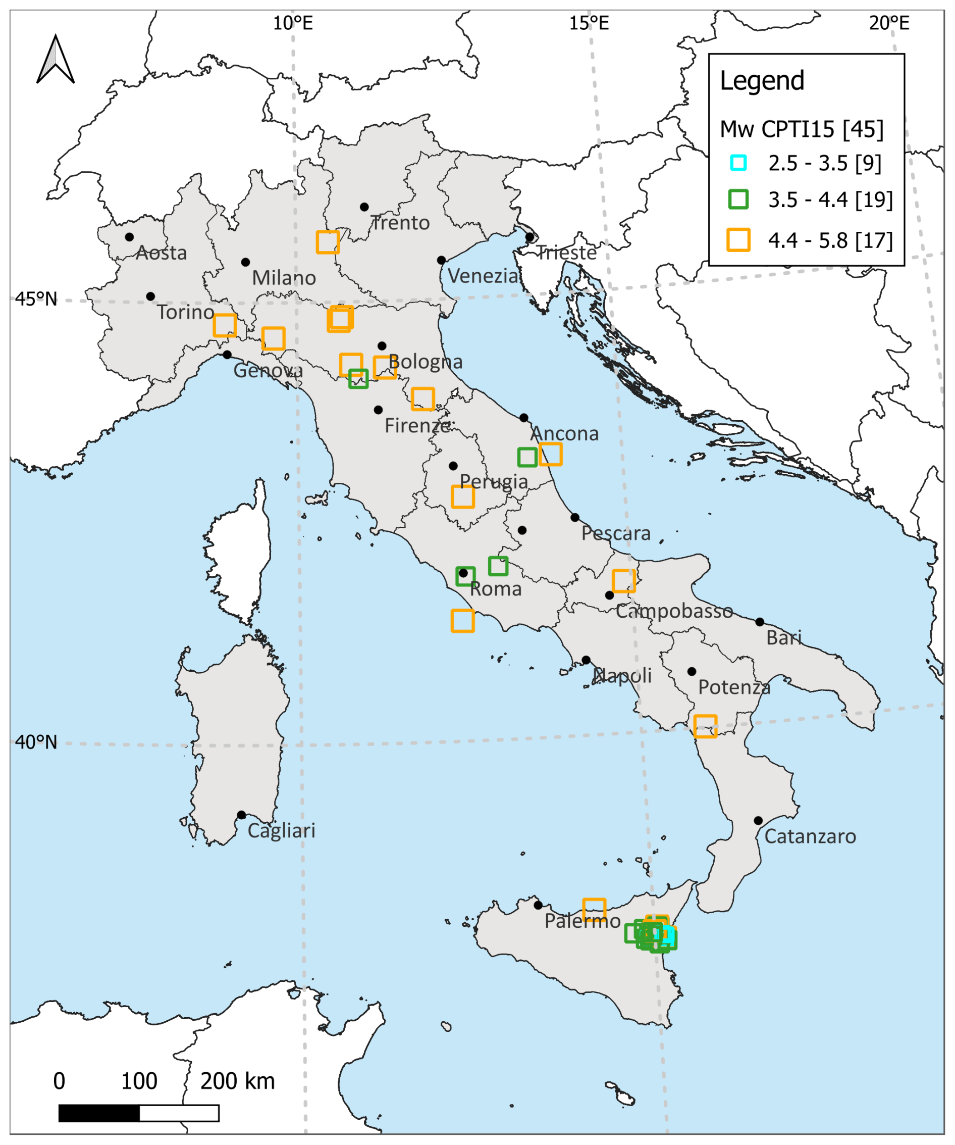
Figure 1Distribution of the selected earthquakes.
3.1 The ING/INGV Macroseismic Bulletin
The Macroseismic Bulletin of Istituto Nazionale di Geofisica e Vulcanologia (INGV; ING before 2000) is the main source of macroseismic data for most of the medium- to low-energy earthquakes that occurred in Italy from 1980 to 2009.
In 1978, the Istituto Nazionale di Geofisica (ING) signed an official agreement with the General Command of the Italian Carabinieri Corps to establish a dense network of correspondents capable of providing a continuous service for the collection of macroseismic observations in the aftermath of earthquakes (Favali et al., 1980). When an earthquake occurred, questionnaires were sent by the ING to the stations of Carabinieri located in a large area around the epicenter. Filled questionnaires were returned to the ING (Fig. 2), where a team of experts processed them and derived estimates of the macroseismic intensities (e.g., Spadea et al., 1983, 1984, 1985). In the following years, the network expanded to include other public bodies, such as the stations of the Italian Municipalities and Forest Guard, in order to increase the quantity and quality of the collected information. In the early 1990s, the network of correspondents consisted of more than 13 000 observation points, covering the entire country (Gasparini et al., 1992). This data collection service remained in operation until 2009.
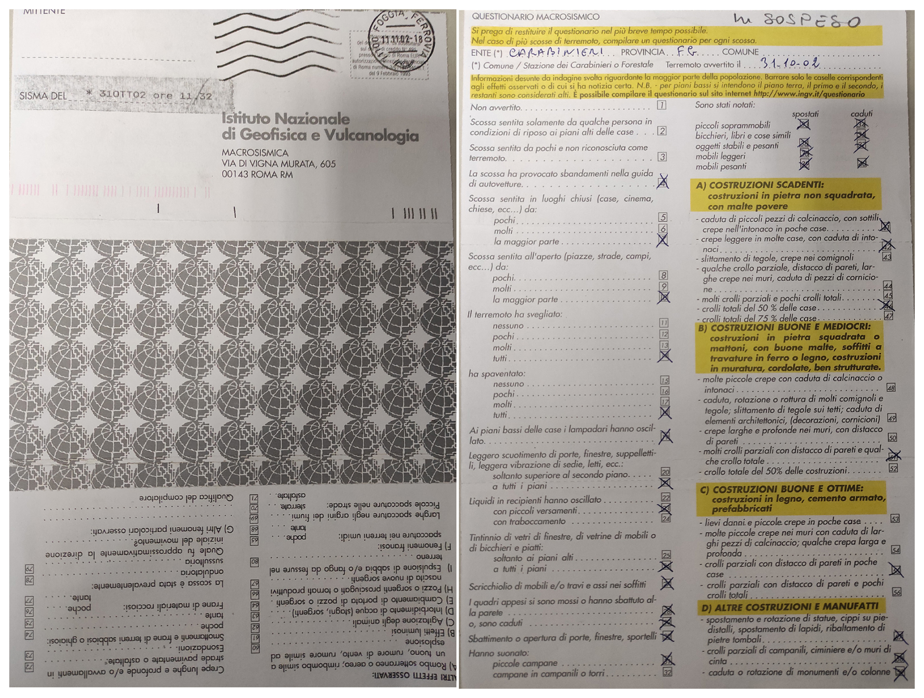
Figure 2Example of a hard-copy questionnaire of the ING Macroseismic Bulletin used during the 1990s.
The threshold earthquake magnitude for data collection was set at approximately 3.0 to gather information on medium- to low-energy earthquakes for which no field surveys would be carried out. The questionnaires included numerous questions on how the earthquake was perceived by people, its effects on objects inside buildings, damage to buildings of different types, and also environmental effects.
Until 1988, the questionnaires were based on the MSK and the MCS scales, and intensity was assigned according to both. From 1988 onwards, they were based on the MCS scale only. The information gathered from questionnaires for each earthquake was used by the ING staff to assess macroseismic intensity for each site, employing an algorithm based on weighted means in order to minimize subjectivity in the estimation of intensities (Gasparini et al., 1992). The resulting macroseismic data were published yearly in a Macroseismic Bulletin as a list of MDPs for each earthquake (e.g., Gasparini et al., 1994, 2003, 2011). The Macroseismic Bulletins used as a source in this study are one of the main data sources employed by the scientific community to study Italian seismicity and for compiling the DBMI15-CPTI15. Over the entire operational period of the Bulletin, intensity data for over 2400 earthquakes were collected, 392 of which have been considered to be the main ref (preferred reference) in the DBMI15-CPTI15, contributing more than 35 000 MDPs. It should be stressed that, unlike direct surveys, a vast majority of the data contained in the Bulletin are characterized by low-intensity values.
3.2 Direct field surveys
Some of the earthquakes considered in this paper are characterized by studies (and related datasets) resulting from macroseismic surveys carried out in the field by teams of experts. Usually, direct macroseismic investigations in earthquake-affected areas are performed for earthquakes exceeding a given magnitude threshold (Bottari et al., 1980; Camassi et al., 2008, 2009). They produce data that, having been collected by specially trained personnel, have a higher level of reliability than those collected through questionnaires. This latter circumstance was taken into account when establishing the criteria adopted in this study for merging the different datasets.
The goal of macroseismic field surveys is to assess intensity at a specific locality by means of direct observation of the effects produced by an earthquake in that locality. These effects can be either transient (those on people and objects) or permanent (building damage). When the scenario shows very minor and sporadic damage, data collection focuses more on transient effects, gathered both through press reviews and, above all, by interviewing the affected populations: people describe how they perceived the shaking and where (i.e., whether indoors or outdoors) and the effects they observed on household objects (oscillations, falls, breakages). Conversely, when widespread damage ranging from moderate to severe occurred, the survey would mainly be focused on building damage and may include vulnerability assessments of the whole building stock. The field-collected data serve as raw inputs, which, when analyzed according to the guidelines of the adopted macroseismic scale, allow the intensity to be estimated (Grünthal, 1998; Molin, 2009).
Over the years, direct survey techniques have evolved, both because they have been influenced by the adoption of different macroseismic scales and also to enhance objectivity in the investigation (Del Mese et al., 2023). As a result, macroseismic data derived from direct field surveys carried out at different times and with different methods can show inconsistencies and inhomogeneity. Such inhomogeneity can mainly be ascribed to the adoption of different macroseismic scales or even to the different geographical extent to which the survey was performed (municipality level vs. hamlet level).
Generally speaking, however, regardless of the period in which they were conducted, the results of direct field investigations are to be considered to be among the most reliable macroseismic data ever.
Due to time constraints and issues related to the availability of skilled personnel to deploy in the field, data from surveys, while detailed in the epicentral areas, often have a rather limited extent in the far field in contrast with data collected with indirect techniques. This is why data derived from direct field surveys are often incomplete in the far field. Therefore, for a given earthquake, these studies are more suitable to be integrated with other studies that provide more complete far-field datasets.
3.3 Other kinds of datasets
Our study includes 26 earthquakes located in the Etna Volcano region (Sicily), whose data come from the Macroseismic Catalogue of Etna Earthquakes (CMTE, Azzaro and D'Amico, 2014). This catalogue – the most updated collection of earthquakes existing in relation to this volcanic area – lists 1874 earthquakes, occurring between 1633 and 2023, including both foreshocks and aftershocks, 220 of which exceed the damage threshold. To date, the related macroseismic database contains 9274 MDPs, with an associated intensity dataset assessed according to the EMS-98 scale. The compilation of the CMTE is the result of the analysis of about 200 primary sources (scientific papers, bulletins, newspapers, archive documents, and direct surveys), providing a complete and homogeneous dataset to investigate local seismicity over the last 4 centuries.
In the 1980s and 1990s, some Italian seismological agencies collected macroseismic information by means of questionnaires distributed to schools to gather dense feedback from students (Esposito et al., 1988; Tertulliani and Donati, 2000). These data are plentiful but often of poor quality due to the impossibility of checking the competence of the compilers. Anyway, at least for some earthquakes, these are the only data available for intensity assessment.
Unifying the results of different macroseismic studies cannot be achieved by a mere combination of intensity values. First, it is necessary to identify homogenization criteria to optimize the quantity and quality of data. As already mentioned, the differences depend on the different methods of data collection (which vary according to historical periods), the macroseismic scale used, and the way it was used. The studies associated with the earthquakes analyzed in this work provide datasets that differ in terms of both the number of MDPs and the intensity values assessed for each point. Sometimes, different studies list the same localities whether or not they are assessing the same intensity value. Conversely, only one of the available studies can report some or many localities for a given earthquake. In fact, by comparing the datasets of each earthquake, we can find the following data layouts:
-
localities that are included in all of the available studies, with identical or different assigned intensities, on the MCS scale;
-
localities that are included in only one of the available studies, with MCS or EMS-98 intensity;
-
localities that are included in all of the available studies, with identical or different assigned intensities, on both the MCS and EMS-98 scales.
To accomplish our task efficiently and systematically, it was necessary to establish transparent criteria and to make a few assumptions about the nature of the data to be processed.
Taking a cue from recent experiences in macroseismology (Musson et al., 2010; Del Mese et al., 2023; Castellano et al., 2018; Bernardini and Ercolani, 2023), we adopted some guidelines that, we believe, can be applied to the entirety of the datasets being compared.
Firstly, we defined the following initial criteria:
- a.
Localities with an intensity value I on the EMS-98 and MCS scales assigned after a field survey have been included in the new dataset without further check, assuming that values assessed by expert personnel are robust and reliable.
- b.
Localities for which a single study assesses I≥5 not resulting from a field survey have been reviewed regardless of what scale is used.
- c.
Localities for which different studies assess two intensity values ≥ 5 on the same scale but with a difference greater than or equal to 1° have been reviewed; such an important difference in terms of intensity requires further evaluation to assess which diagnostics led to different estimates.
- d.
For localities in which different studies assess two intensity values < 5 on the same scale but which differ from each other by half a degree of intensity (i.e., I1=4–5 and I2=4), the integer value between the two (i.e., I=4) has been assigned in accordance with to the EMS-98 guidelines.
- e.
Localities for which a single study reports I<5 have been included in the new dataset without further verification. For lower intensity levels, where the estimation relies on transient effects, the literature (e.g., Musson et al., 2010; Sbarra et al., 2020) indicates that MCS and EMS-98 estimates are roughly equivalent. Therefore, regardless of the scale, the intensity value can be considered to be reliable for both the MCS and EMS-98 datasets.
In the case of localities with intensities from different scales, we note the following:
-
I=5–6 on the MCS has been considered to be equivalent to I=5 on the EMS; this assumption is based on the different definitions of intensity degrees 5 and 6 on the two scales – specifically, the onset of damage to buildings is expected at intensity degree 5 in the EMS-98 and at intensity degree 6 in the MCS scale.
-
I<5 on the MCS is considered to be equal to the same EMS-98 value; for this assumption, see criterion e above.
In addition, in all cases where the intensities assigned to localities in different studies have shown significant differences or when the available data are doubtful or lacking, a revision has been done.
It should be noted that, very often, the raw data collected either through direct surveys or through questionnaires are aimed at defining an intensity estimate according to the MCS scale. However, in order to assign an EMS-98 intensity from these data, we had to make some reasonable assumptions to compensate for the lack of information on building vulnerability classes, damage grades, and observed damage frequency. To overcome this criticality, the information contained in the questionnaires can be helpful. The latter, though not required to fulfill EMS-98 diagnostics, was meant to assess intensity based on the MSK scale, from which the EMS-98 is directly derived. By means of a careful examination of the answers to questionnaires, we were able to obtain a rough estimate of vulnerability classes and damage grades.
Three significant examples of this revision process are represented by the earthquakes that occurred in 1987 in the Marche region (central Italy), in 2002 in the Molise region (southern Italy), and in the Etna volcanic area.
The earthquake of 3 July 1987 (https://emidius.mi.ingv.it/ASMI/event/19870703_1021_000, last access: June 2025), with a moment magnitude (Mw) of 5.06 and a maximum epicentral intensity (Imax) of 7 on the MCS, underwent a significant revision based on two main sources: the ING Macroseismic Bulletin (Gasparini et al., 1988), which is the preferred study of the DBMI15-CPTI15 and contains 359 MDPs (Fig. 3a), and the study by Monachesi and Raccichini (Monachesi G., Raccichini S., (1987). Il terremoto di Porto San Giorgio (AP) del 3.7.1987. Indagine macrosismica diretta (nota preliminare). Osservatorio Geofisico Sperimentale. In Italian), which provides 36 MDPs obtained from direct field surveys. The analysis, which involved 78 specific checks, led to substantial modifications of the original datasets (Fig. 2b). In particular, seven MDPs reported in the ING Macroseismic Bulletin were excluded from the Tertulliani et al. (2024) dataset as the effects initially attributed to this event were subsequently linked to the earthquake of 5 July of the same year, which occurred close to the felt area of the studied event (https://emidius.mi.ingv.it/ASMI/event/19870705_1312_000, last access: June 2025). Due to the absence of original questionnaires and the presence of contradictory information, it was not possible to assign an intensity value for six localities. The revision work also identified questionnaires related to six previously unconsidered localities and added them to the intensity data, now consisting of 373 MDPs (Fig. 3b). Furthermore, in this study, the maximum intensity, initially estimated to be 7 on the MCS in the ING Macroseismic Bulletin, has been revised to 6–7 on the MCS and 6 on the EMS-98.
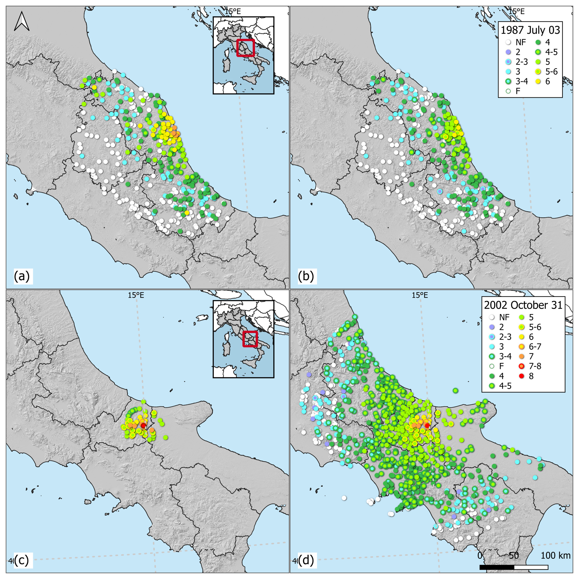
Figure 3Intensity distribution of 3 July 1987 (a) and 31 October 2002 earthquakes (c) as reported in the DBMI15 using the MCS and this study (b) and (d) on the EMS-98 scale.
We also calculated the macroseismic magnitude MwM with the algorithm proposed by Gasperini et al. (1999, 2010) using the resulting intensity data (Tertulliani et al., 2024). The estimated MwM is equal to 4.94 for the event that occurred on 3 July 1987 and differs by 0.34 units from those of the Italian catalogue (i.e., MwM 5.28). This difference can be attributed to the downward reassessment of the intensities of several localities. In addition, the macroseismic magnitudes estimated from the new datasets (i.e., MwM 4.94 for the MCS dataset and 4.96 for the EMS-98 one) show good agreement with the available instrumental estimate (i.e., Mw 5.06).
The second significant case study concerns the Molise earthquake of 31 October 2002 (https://emidius.mi.ingv.it/ASMI/event/20021031_1032_000, last access June 2025), with Mw of 5.74 and Imax of 8–9 on the MCS. For this event, the data from the preferred study of the DBMI15-CPTI15 (Bosi et al., 2002), with 51 MDPs, and of the INGV Macroseismic Bulletin (Gasparini et al., 2011), with 790 MDPs, were analyzed (Fig. 3c). Bosi et al. (2002) is a technical report compiled after the direct survey in the aftermath of the earthquake, focusing on near-field effects, while Gasparini et al. (2011) extended the data collection into the far field. Our revision, which required 168 specific checks, highlighted many necessary changes in the intensity evaluation: for a specific locality, the intensity was reduced after a careful analysis of both photographic documentation and field survey descriptions. The final result of this revision led to an increase in the number of MDPs to 798 (Fig. 3d) compared to the reference study of the DBMI15-CPTI15 (51 MDPs), integrating the epicentral data with the observed effects in the far field. In this case, the macroseismic magnitudes (MwM 5.27 for both datasets) are very similar to the macroseismic magnitude reported in the CPTI15 (i.e., MwM 5.33), and the difference between the instrumental magnitude (Mw 5.74) provided by the Italian catalogue and the macroseismic magnitudes obtained with the data reported in this study is equal to 0.47 units. The errors associated with the new estimates are significantly reduced, from ±0.23 to 0.04.
The third example is the earthquake recorded in the Etna area, near Piano Provenzana, on 27 October 2002 (https://emidius.mi.ingv.it/ASMI/event/20021027_0250_000, last access: June 2025), with Mw of 4.84 and maximum intensity equal to 8 on the EMS-98 (Fig. 4a). The revision of this event has been based on two sources: the direct field survey by Azzaro et al. (2006), which is the preferred study of the DBMI15-CPTI15, providing 17 MDPs, and the INGV Macroseismic Bulletin (Gasparini et al., 2011), which lists 101 MDPs.
The analysis included 54 specific checks, and, for 7 of these, only the intensity data from the direct survey were available. Additionally, four MDPs reported in the INGV Macroseismic Bulletin were excluded by Tertulliani et al. (2024) because the revised questionnaires were unreliable.
In this case, the revision work also led to an important increase in the number of MDPs, which now totals 106 MDPs (Fig. 4b), and the maximum intensity has been confirmed to be 8 on the EMS-98. The macroseismic magnitudes calculated with the relationship developed by D'Amico et al. (2025) for the volcanic region of Mt. Etna are equal to 4.19 for both scales.
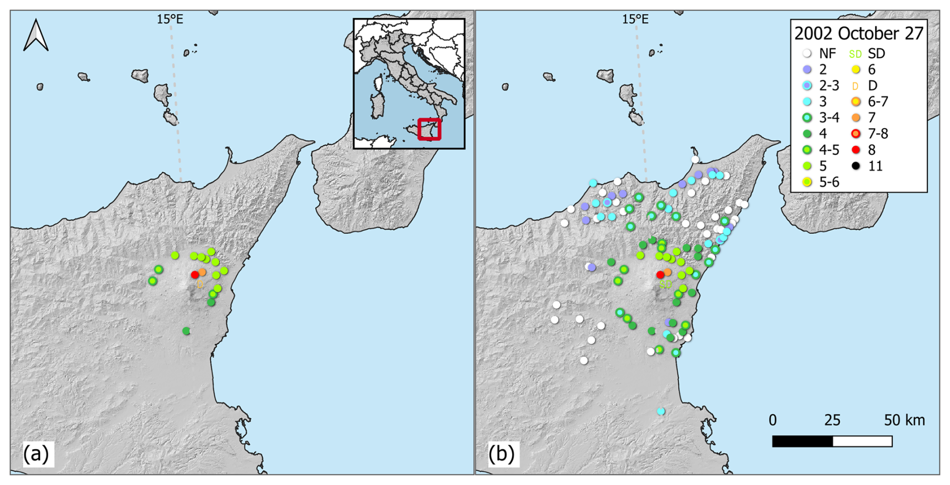
Figure 4Intensity distribution using the EMS-98 scale of the 27 October 2002 earthquakes, as in the DBMI15 (MDP set by Azzaro et al. (2006)) (a) and in this study (b).
This work allowed us to reconstruct a new complete dataset (Tertulliani et al., 2024) for 45 Italian earthquakes that occurred from 1985 to 2006. It represents the final result of a systematic harmonization and homogenization of both intensity data and geographical coordinates for each locality. This task was performed by a careful check of about 2000 macroseismic questionnaires (see Sect. 3.1) and of many other sources of various kinds. During this work, we were also able to correct several misinterpretations in the previous assessment of intensity, verifying the accuracy of the match between the effects produced and the assigned intensity. In this respect, 53 MDPs contained in the macroseismic bulletins were discarded from Tertulliani et al. (2024): 46 MDPs had incorrectly filled out questionnaires providing ambiguous information, while 7 MDPs mistakenly referred to one event instead of another.
For the 45 earthquakes studied (Tertulliani et al., 2024), the number of intensity data has increased from the 2892 MDPs currently included in the DBMI15 to 9328 MDPs as the final result of the present work. As Fig. 5 and Table A1 show, for 10 of the considered earthquakes, the number of MDPs increased by more than 500 % with respect to those presently collected in the DBMI15, while, for the other 25 earthquakes, the increase in the number of points was greater than 100 %.
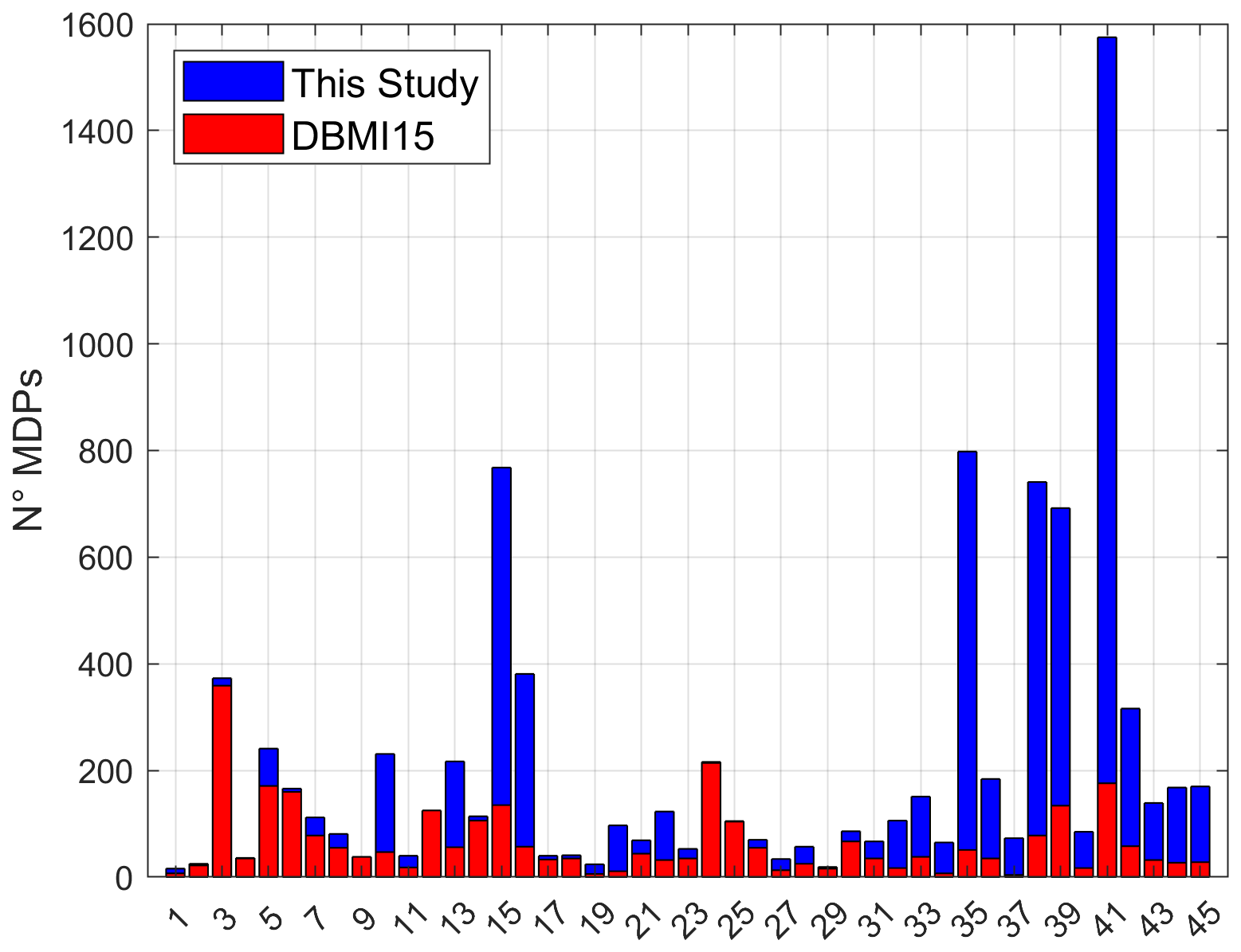
Figure 5Number of MDPs of the selected earthquakes as reported in the DBMI15 (red bars) and in this study (blue bars). On the horizontal axis is the progressive number of the studied earthquakes, as reported in Appendix A.
Furthermore, the intensity data contained in Tertulliani et al. (2024) are now provided for both the MCS and the EMS-98 scale. Figure 6 shows the data distribution as a function of each intensity degree, showing that the frequency of each intensity class is higher than those reported in the DBMI15 for both macroseismic scales. In particular, Fig. 6a shows that, after the revision, the number of data points is 105 and 845 for intensities 6 and 5 on the EMS-98, respectively, increasing by, respectively, 320 % and 754 %, whereas Fig. 6b shows that the number of data points for the MCS is equal to 993 for intensity 3 and 1370 for intensity 4–5, corresponding to an increase of 397 % and 512 %, respectively. In addition, for intensity 5–6, the number of total data points is slightly different between the two scales: 246 MDPs are present for the MCS and 120 are present for the EMS-98. This discrepancy is due to the different diagnostics used by the two scales for the degrees 5 and 6.
This huge increment of MDPs with intensity < 6 means that, unlike previously, the macroseismic data for many of the studied earthquakes are now representative of the entire impact area of the event, from the epicentral area to the far field, where the earthquake was felt only slightly. In fact, the increase in the number of low-intensity data is complemented by the significant amount of data related to localities situated at great epicentral distances. Figure 7 shows that, for the studied events, for I<5, the number of data points for distances > 100 km is significantly higher than that contained in the DBMI15. Indeed, considering intensities ≥ 2, Tertulliani et al. (2024) provide 1157 MDPs located at epicentral distances > 100 and 78 MDPs at distances > 200 km with respect to the 171 MDPs and the 9 MDPs included in the DBMI15 for the same distances.
As a result of the revision, the total amount of data contained in the dataset is related to 5027 Italian localities. Out of these, 129 were not reported in the DBMI15, while 3151 localities, related to the examined earthquakes, have been assigned a new intensity value.
Going into detail, the earthquake that showed the greatest increase in the amount of data is the one that occurred in northern Italy on 24 November 2004 (ID no. 41: https://emidius.mi.ingv.it/ASMI/event/20041124_2259_000, last access: 28 October 2024), for which, thanks to the results of our study, a total of 1575 MDPs are now available compared to 176 MDPs currently included in the DBMI15.
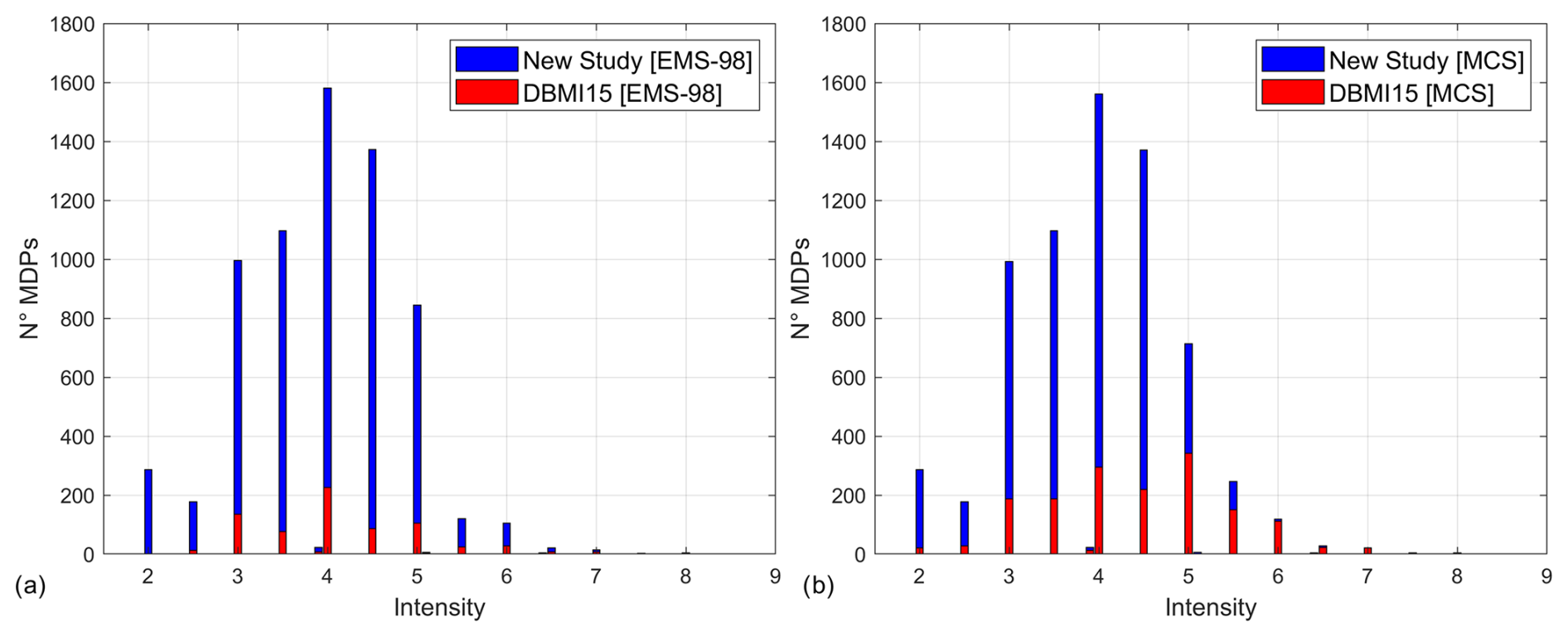
Figure 6Number of MDPs as a function of each intensity degree on the EMS-98 (a) and the MCS (b) provided in this study (blue bars) and in the DBMI15 (red bars).
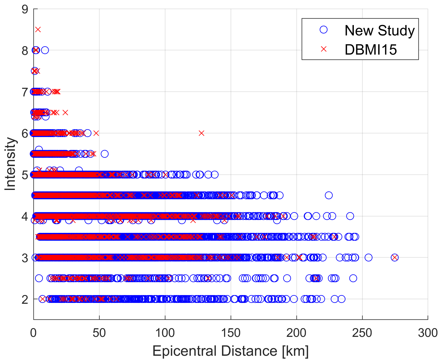
Figure 7Epicentral distance vs. intensity class of the data contained in the new study (blue) and in the DBMI15 (red).
Having access to a large dataset of intensity data for both the EMS-98 and MCS has also allowed us to carry out a comparative analysis of macroseismic magnitude estimates derived from the two scales. To this end, we calculated the macroseismic magnitude for each selected event (Appendix A) using intensity data expressed for both the EMS-98 and MCS. For the 19 earthquakes that occurred in the volcanic region of Mt. Etna, macroseismic magnitudes were estimated using the most recent relationship developed by D'Amico et al. (2025), whereas the remaining 26 events were calculated using the algorithm proposed by Gasperini et al. (1999, 2010). As expected, the comparison between magnitudes based on EMS-98 and MCS data shows no significant differences: the average difference between the macroseismic magnitudes derived from the two scales is small, amounting to −0.01 units. In detail, Fig. 8 shows that the differences between macroseismic magnitudes estimated using EMS-98 and MCS data do not exceed 0.2 magnitude units.
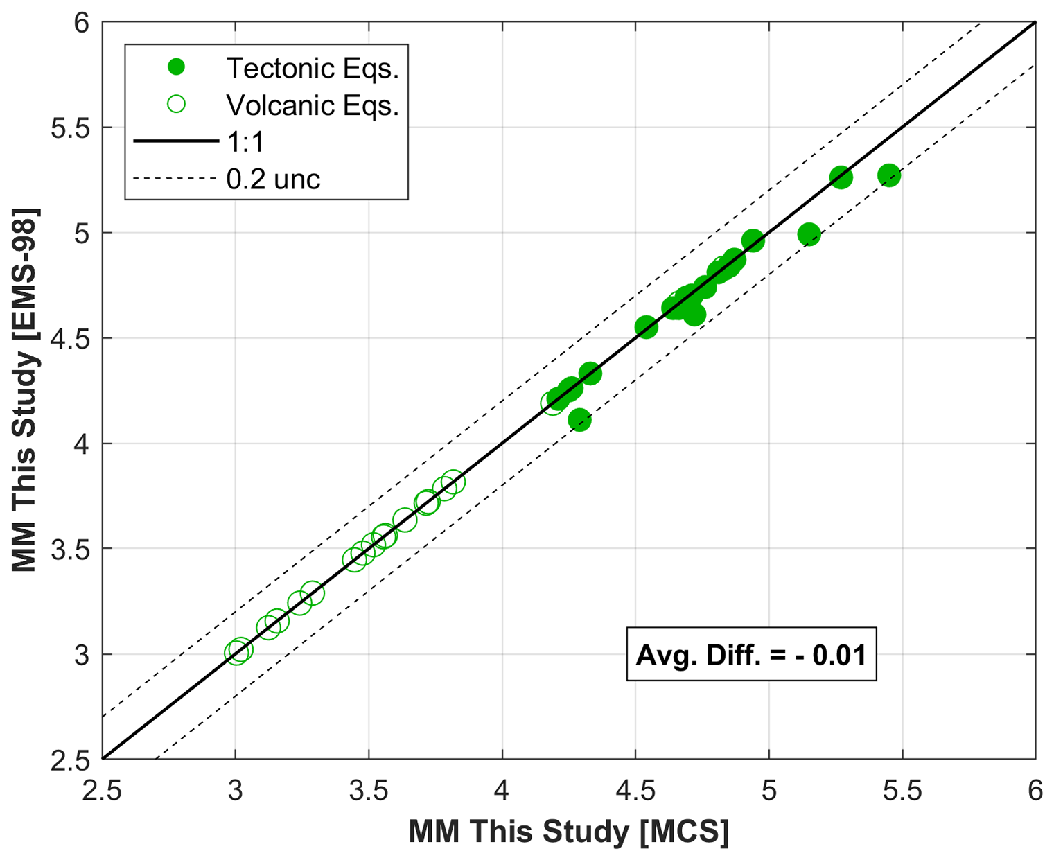
Figure 9 shows the comparison between the macroseismic estimates derived from the dataset introduced in this study and the instrumental magnitudes available from the CPTI15 catalogue. This analysis has been performed only for tectonic earthquakes as, for the volcanic events, the macroseismic magnitude was obtained by the calibration with the local magnitude (Ml) (D'Amico et al., 2025), not directly comparable with Mw magnitude.
Although some differences are observed, the average difference between the instrumental moment magnitude and the macroseismic magnitude is minimal, with an average difference of −0.05 units.
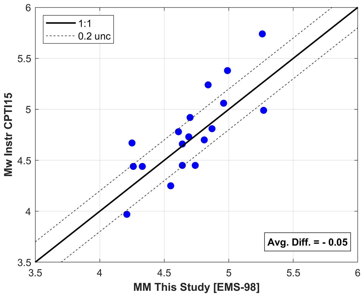
Figure 9Comparison between the macroseismic magnitude obtained with our dataset for the EMS-98 scale and the instrumental magnitude reported in the CPTI15.
In contrast, Fig. 10 shows the comparison between instrumental magnitudes and the macroseismic estimates currently included in the CPTI15 catalogue, which exhibit a larger average difference of −0.17 units. These results highlight a significant improvement achieved through the revised dataset proposed in this study.
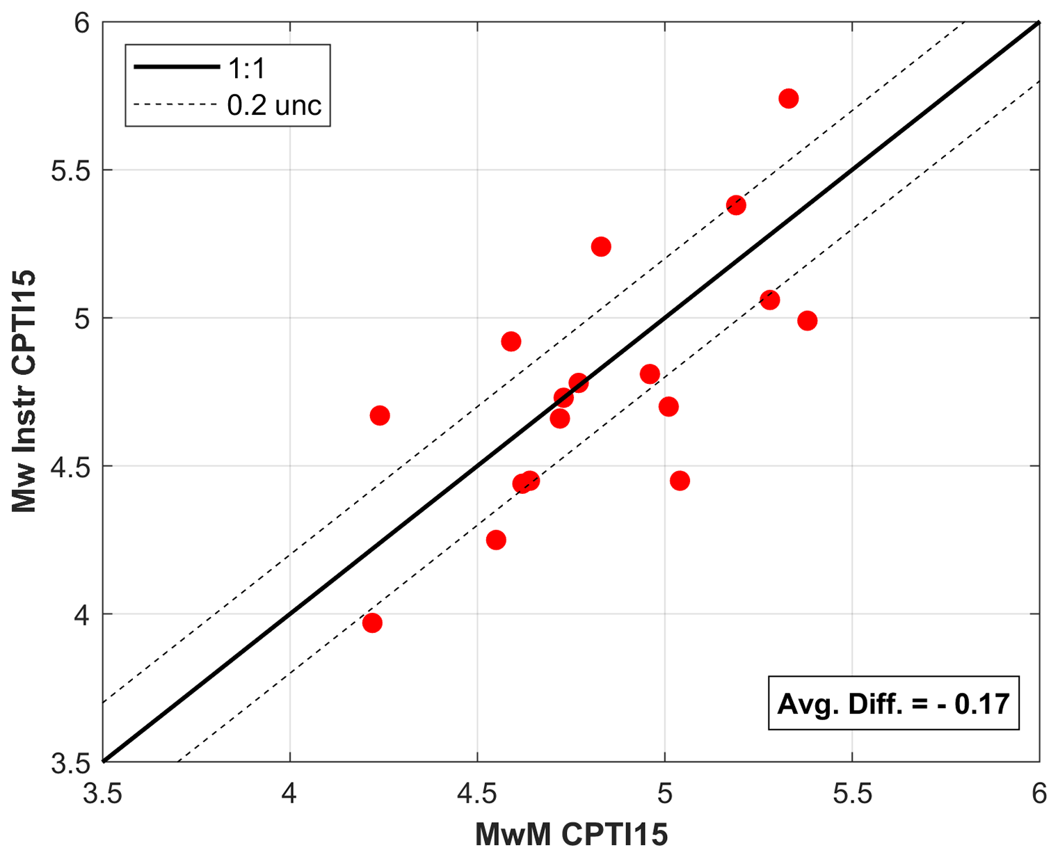
Figure 10Comparison between the macroseismic magnitude and the instrumental magnitude reported in the CPTI15.
Figure 11 shows the differences of each event between instrumental magnitudes reported in the CPTI15 and two sets of macroseismic magnitudes: those derived in this study (blue dots) and those reported in the CPTI15 (red dots). We excluded the earthquakes that occurred in the Etna region from this analysis.
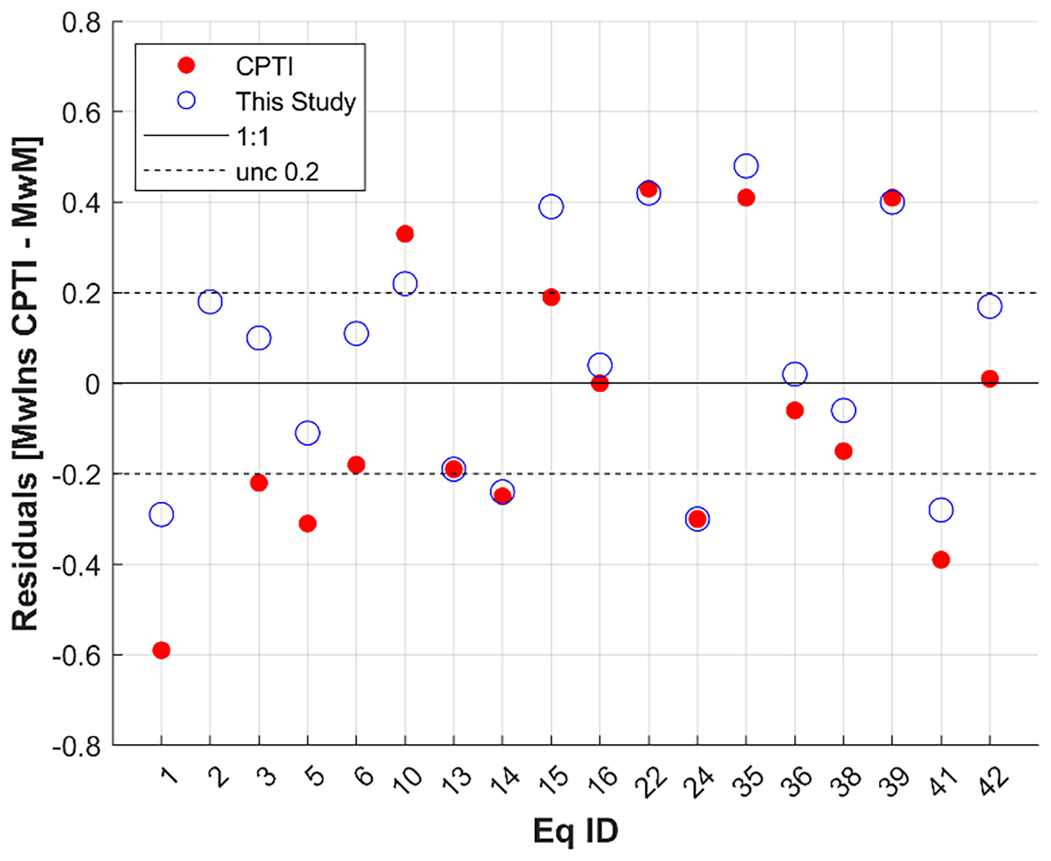
Figure 11Residuals between the instrumental magnitudes of the CPTI15 and macroseismic magnitudes obtained in this study (blue dots) and those reported in the CPTI15 (red dots). The x axis shows the event ID nos. as listed in Appendix A.
The promising results obtained from this study motivate the extension of this methodology to other earthquakes for which multiple studies are available in the CPTI15.
The integrated dataset (Tertulliani et al., 2024) is available at https://doi.org/10.13127/macroseismic/teral024, and it has been released under a Creative Commons Attribution 4.0 International (CC BY 4.0) license. The data file is downloadable in both Portable Document Format (.pdf) and MS Excel (.xlsx) format through the ASMI web portal (https://doi.org/10.13127/asmi, Rovida et al., 2017). The downloadable spreadsheets contain the list of 9328 MDPs, as described in the previous sections, together with the associated references and format descriptions of the contained field. The dataset is also available through the ASMI's web services (https://doi.org/10.13127/asmi, Rovida et al., 2017) according to the standards of the International Federation of Digital Seismograph Networks (fdsnws-event) and the Open Geospatial Consortium, particularly the Web Feature Service (OGC WFS) and the Web Map Service (OGC WMS).
In this work, we made a revision with the goal of making a new and complete dataset for several earthquakes, with the aim of including all MDPs coming from different macroseismic studies. In this respect, we identified several criteria aiming at integrating different datasets into a unique, reliable intensity compilation in a fast and robust way. Tertulliani et al. (2024) represent the result of this compilation of a total of 9328 MDPs related to 45 Italian earthquakes that occurred from 1985 to 2006, expressed according to the macroseismic scales of the EMS-98 and MCS. This dataset allows us to strongly increase the total number of data points available with respect to those already contained in the DBMI15 (from 2892 to 9328 MDPs) and to make the macroseismic distribution of the 45 events more solid, robust, and extensive.
In addition, the increment of the MDPs has allowed us to broaden the spatial distribution of the intensity observations, making it possible to include many data from the far field of the considered events. This, arguably, has positive influences on the parameterizations of the events themselves, which are now based on more exhaustive datasets.
An important finding of our study has been the improvement of the “seismic histories” (i.e., the list of earthquakes experienced through time by a locality) of 3151 Italian localities. Indeed, for many of the localities affected by the examined earthquakes, an intensity value was assigned for the first time as a result of our study: up to now, these places were not known to have experienced seismic events. As a relevant fact, it has to be underlined that the 45 analyzed earthquakes occurred in an era in which instrumental data already had high reliability. This offers the possibility of using this large amount of new intensity data for many seismological purposes, such as calibrating the methods for deriving earthquake parameters, the intensity prediction equations (IPEs), and the ground-motion-to-intensity conversion equations (GMICEs).
The concept of conducting a review based on objective criteria makes this methodology broadly applicable to other earthquakes, enabling a more efficient and systematic enhancement of knowledge about Italian seismicity. This approach avoids the need for exhaustive earthquake re-evaluation and focuses instead on addressing cases where datasets exhibit potential inconsistencies or non-homogeneity. In our analysis, only 1783 out of 9328 MDPs were re-examined, demonstrating the efficiency of the review process and its ability to streamline efforts without compromising reliability. The proposed methodology is particularly effective for the rapid yet reliable updating of medium to low earthquakes, which are characterized by a vast amount of low-intensity data. Such kinds of earthquakes are not only numerous but also critical for understanding regional seismic activity. While they often do not cause major damage, they are significant because they can still generate notable shaking, leading to localized damage and fright among the population. Consequently, studying them is essential for refining historical seismic histories and for contributing to the enhancement of the seismic hazard of a given area.
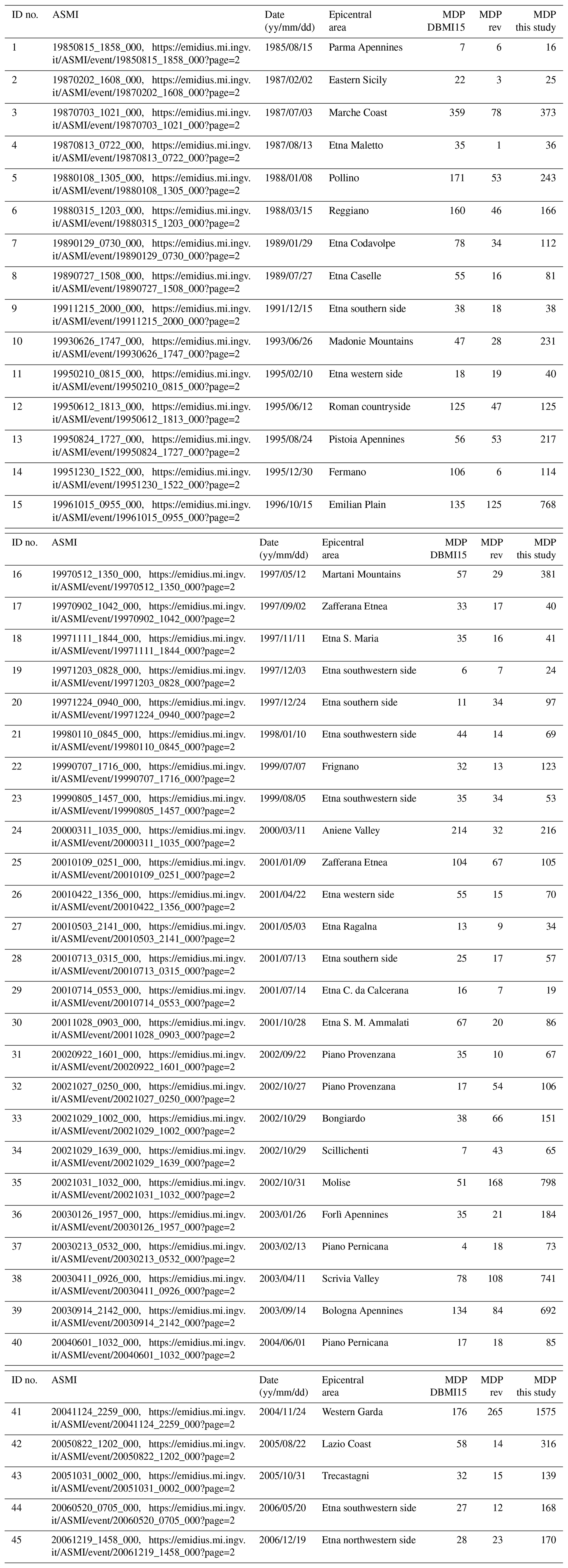
Table A1ID no., ASMI link, data, and epicentral area of the 45 selected earthquakes, with their number of MDPs as reported in the DBMI15 (MDP DBMI15), the number of data revised (MDP rev), and the total number provided by this study (MDP this study).
All links were accessed in June 2025.
AT designed the research and led the discussions. All of the co-authors wrote the initial paper and edited all of the following versions. All of the co-authors contributed to the dataset compilation. AA made all of the figures and the dataset elaborations.
The contact author has declared that none of the authors has any competing interests.
Publisher’s note: Copernicus Publications remains neutral with regard to jurisdictional claims made in the text, published maps, institutional affiliations, or any other geographical representation in this paper. While Copernicus Publications makes every effort to include appropriate place names, the final responsibility lies with the authors.
The authors would like to thank referee 1, Paolo Gasperini, for his thoughtful and constructive comments, which helped improve the clarity and overall quality of the paper. We also thank referee 2, Ludmila Provost, for her careful reading. We are grateful to both for appreciating our work and for clearly understanding its aims and objectives.
This paper was edited by Kirsten Elger and reviewed by Paolo Gasperini and Ludmila Provost.
Azzaro, R., D'Amico, S., Mostaccio, A., Scarfì, L., and Tuvè, T.: Terremoti con effetti macrosismici in Sicilia orientale nel periodo Gennaio 2002–Dicembre 2005, Quaderni di Geofisica, 41, Istituto Nazionale di Geofisica e Vulcanologia (INGV), Roma, 62 pp., 2006 (in Italian).
Azzaro, R. and D'Amico, S.: Catalogo Macrosismico dei Terremoti Etnei (CMTE), 1633–2023, Istituto Nazionale di Geofisica e Vulcanologia (INGV), https://doi.org/10.13127/cmte, 2014.
Bernardini, F. and Ercolani, E.: Rilievo macrosismico del terremoto dell'Appennino Tosco-Romagnolo (Mw = 4.9) del 18 settembre 2023 – ore 5:10 locali, Rapporto finale del 2 ottobre 2023, QUEST-INGV [data set], https://www.earth-prints.org/handle/2122/16564 (last access: May 2025), 2023.
Bosi, V., Galli, P., Gallipoli, M. R., Del Mese, S., Massucci, A., Rossi, A., Camassi, R., Ercolani, E., Piccarreda, C., Bernardini, F., Tertulliani, A., Vecchi, M., Maramai, A., and Mucciarelli, M.: Rilievo degli effetti prodotti dalla sequenza sismica molisana dell'ottobre-novembre 2002, Rapporto tecnico QUEST, Istituto Nazionale di Geofisica e Vulcanologia (INGV), Roma, 13 pp. https://doi.org/10.13127/QUEST/20021031, 2002 (in Italian).
Bottari, A., Lo Giudice, E., and Spadea, M. C.: Critical considerations on the evaluation of macroseismic effects, Ann. Geophys., 33, 261–280, https://doi.org/10.4401/ag-4708, 1980.
Camassi, R., Azzaro, R., and Tertulliani, A.: Macroseismology: the lessons we have learnt from the 1997/98 Colfiorito seismic sequence, Ann. Geophys., 51, 331–342, 2008.
Camassi, R., Galli, P., Tertulliani, A., Castenetto, S., Lucantoni, A., Molin, D., Naso, G., Peronace, E., Bernardini, F., Castelli, V., Cavaliere, A., Ercolani, E., Salimbeni, S., Tripone, D., Vannucci, G., Arcoraci, L., Berardi, M., Castellano, C., Del Mese, S., Graziani, L., Leschiutta, I., Maramai, A., Massucci, A., Rossi, A., Vecchi, M., Azzaro, R., D'Amico, S., Ferrari, F., Mostaccio, N., Platania, R., Scarfì, L., Tuvé, T., Zuccarello, L., Carlino, S., Marturano, A., Albini, P., Capera, A. G., Locati, M., Meroni, F., Pessina, V., Piccarreda, C., Rovida, A., Stucchi, M., Buffarini, G., Paolini, S., Verrubbi, V., Mucciarelli, M., Gallipoli, M.R., Barbano, M. S., Cecic, I., and Godec, M.: Macroseismic investigation: methodology, earthquake parameters, unresolved issues, Progettazione Sismica, 03 Special Issue, 47–53, 2009.
Castellano, C., Del Mese, S., Fodarella, A., Graziani, L., Maramai, A., Tertulliani, A., and Verrubbi, V.: Quest- Rilievo Macrosismico per i terremoti del Molise del 14 e 16 agosto 2018, Zenodo [data set], https://doi.org/10.5281/ZENODO.1405385, 2018.
D'Amico, S, Tuvè, T., and Mantovani A.: New relationships between macroseismic intensity and local magnitude for the volcanic region of Mt. Etna (Italy), J. Seismol., 29, 305–315, https://doi.org/10.1007/s10950-024-10274-9, 2025.
Del Mese, S., Graziani, L., Meroni, F., Pessina, V., and Tertulliani, A.: Considerations on using MCS and EMS-98 macroseismic scales for the intensity assessment of contemporary Italian earthquakes, Bull. Earthq. Eng., 21, 4167–4189 https://doi.org/10.1007/s10518-023-01703-0, 2023.
Esposito, E., Guerra, I., Marturano, A., Luongo, G., and Porfido, S.: Il terremoto dell'8 gennaio 1988 (ML=4.1) in Calabria Settentrionale, Atti del 7° Convegno Annuale del GNGTS, 3, 1637–1646, 1988 (in Italian).
Favali, P., Giovani, L., Spadea, M. C., and Vecchi, M.: Il terremoto della Valnerina del 19 Settembre 1979. Indagine macrosismica, Ann. Geophys., 33, 67–100, https://doi.org/10.4401/ag-4696, 1980 (in Italian).
Gasparini, C., De Rubeis, V., and Tertulliani, A.: A method for the analysis of macroseismic questionnaires, Nat. Hazards 5, 169–177, https://doi.org/10.1007/BF00127004, 1992.
Gasparini, C., Anzidei, M., Maramai, A., Murru, M., Riguzzi, F., Tertulliani, A., Cardoni, M., Del Mese, S., Vannucci, C., Vecchi, M., and Massucci, A.: Bollettino macrosismico 1987, Istituto Nazionale di Geofisica, Roma, 47 pp., https://emidius.mi.ingv.it/ASMI/study/BMING988 (last access: June 2025), 1988.
Gasparini, C., Tertulliani, A., Riguzzi, F., Anzidei, M., Maramai, A., Murru, M., De Rubeis, V., Vecchi, M., Del Mese, S., Vannucci, C., Conte, S., Massucci, A., and Saraceni, A. M.: Bollettino macrosismico 1991, Istituto Nazionale di Geofisica, Roma, 285 pp., https://emidius.mi.ingv.it/ASMI/study/BMING994 (last access: June 2025), 1994 (in Italian).
Gasparini, C., Conte, S., Rocchetti, E., Saraceni, A. M., and Vannucci, C.: Bollettino macrosismico 1999, Istituto Nazionale di Geofisica, Roma [data set], 99 pp., 2003.
Gasparini, C., Conte, S., and Vannucci, C. (Eds.): Bollettino macrosismico 2001–2005, CD-ROM, Istituto Nazionale di Geofisica e Vulcanologia, Roma [data set], 2011.
Gasperini, P., Bernardini, F., Valensise, G., and Boschi, E.: Defining seismogenic sources from historical earthquake felt reports, Bull. Seismol. Soc. Am., 89, 94–110, 1999.
Gasperini, P., Vannucci, G., Tripone, D., and Boschi, E.: The Location and Sizing of Historical Earthquakes Using the Attenuation of Macroseismic Intensity with Distance, Bull. Seismol. Soc. Am., 100, 2035–2066, https://doi.org/10.1785/0120090330, 2010.
Graziani, L., Tertulliani, A., Maramai, A., Rossi, A., and Arcoraci, L.: The 7 and 11 May, 1984 earthquakes in Abruzzo-Latium (Central Italy): reappraisal of the existing macroseismic datasets according to the EMS98, J. Seismol., 21, 1219–1227, https://doi.org/10.1007/s10950-017-9663-3, 2017.
Grünthal, G. (Ed.): European Macroseismic Scale 1998, Vol. 13, Conseil de l'Europe, Cahiers du Centre Européen de Géodynamique et de Séismologie, Luxembourg, Luxembourg, 99 pp., ISBN N2-87977-008-4, 1998.
Guidoboni, E., Ferrari, G., Mariotti, D., Comastri, A., Tarabusi, G., Sgattoni, G., and Valensise, G.: CFTI5Med, Catalogo dei Forti Terremoti in Italia (461 a.C.–1997) e nell’area Mediterranea (760 a.C.–1500), Istituto Nazionale di Geofisica e Vulcanologia (INGV) [data set], https://doi.org/10.6092/ingv.it-cfti5, 2018.
Locati, M., Camassi, R., Rovida, A., Ercolani, E., Bernardini, F., Castelli, V., Caracciolo, C. H., Tertulliani, A., Rossi, A., Azzaro, R., D'Amico, S., and Antonucci, A.: Italian Macroseismic Database (DBMI15), version 4.0, Istituto Nazionale di Geofisica e Vulcanologia (INGV) [data set], https://doi.org/10.13127/dbmi/dbmi15.4, 2022.
Medvedev, S. V., Sponheuer, W., and Karnik, V.: Seismic intensity scale version MSK 1964, Academy of Sciences of the USSR, Soviet Geophysical Committee, Moscow, 1965.
Molin, D.: Rilievo macrosismico in emergenza, Technical Report, Dipartimento della Protezione Civile, Ufficio III, Valutazione, prevenzione e mitigazione del rischio sismico, Roma, 2009 (in Italian).
Musson, R. M. W., Grünthal, G., and Stucchi, M.: The comparison of macroseismic intensity scales, J. Seismol., 14, 413–428, https://doi.org/10.1007/s10950-009-9172-0, 2010.
Orlando, M., Tertulliani, A., Antonucci, A., Bernardini, F., Castelli, V., Ercolani, E., Graziani, L., Maramai, A., Rossi, A., and Tuvè, T.: An approach for the integration of macroseismic datasets of different nature: application to the Parametric Catalogue of Italian Earthquakes (CPTI15), 39th ESC Assembly, Corfù, 2024.
Quitoriano, V. and Wald, D. J.: USGS “Did You Feel It?” – Science and lessons from 20 years of citizen science-based macroseismology, Front. Earth Sci., 8, p. 120, https://doi.org/10.3389/feart.2020.00120, 2020.
Rovida, A., Locati, M., Antonucci, A., and Camassi, R.: Archivio Storico Macrosismico Italiano (ASMI), Istituto Nazionale di Geofisica e Vulcanologia (INGV) [data set], https://doi.org/10.13127/asmi, 2017.
Rovida, A., Locati, M., Camassi, R., Lolli, B., and Gasperini, P.: The Italian earthquake catalogue CPTI15, B. Earthq. Eng., 18, 2953–2984, https://doi.org/10.1007/s10518-020-00818-y, 2020.
Rovida, A., Locati, M., Camassi, R., Lolli, B., Gasperini, P., and Antonucci, A.: Italian Parametric Earthquake Catalogue (CPTI15), version 4.0, Istituto Nazionale di Geofisica e Vulcanologia (INGV) [data set], https://doi.org/10.13127/cpti/cpti15.4, 2022.
Rovida, A., Locati, M., Antonucci, A., and Camassi, R.: The Italian Archive of Historical Earthquake Data, ASMI, Earth Syst. Sci. Data Discuss. [preprint], https://doi.org/10.5194/essd-2024-467, in review, 2024.
Sbarra, P., Tosi, P., and De Rubeis, V.: Web-based macroseismic survey in Italy: Method validation and results, Nat. Hazards, 54, 563–581, https://doi.org/10.1007/s11069-009-9488-7, 2010.
Sbarra, P., Tosi, P., De Rubeis, V., and Sorrentino, D.: Quantification of earthquake diagnostic effects to assess low macroseismic intensities, Nat. Hazards, 104, 1957–1973, https://doi.org/10.1007/s11069-020-04256-6, 2020.
Spadea, M. C., Vecchi, M., and Del Mese, S.: Bollettino macrosismico 1981, Istituto Nazionale di Geofisica, Roma, 10 pp., 1983.
Spadea, M. C., Vecchi, M., and Del Mese, S.: Bollettino macrosismico 1982, Istituto Nazionale di Geofisica, Roma, 23 pp., 1984.
Spadea, M. C., Vecchi, M., and Del Mese, S.: Bollettino macrosismico 1983, Istituto Nazionale di Geofisica, Roma, 25 pp., 1985.
Sieberg, A.: Die Erdbeben. In: Handbuch der Geophysik, edited by: Gutenberg, B., Erdbeben, Sect. V. Gebrüder Bornträger, Berlin, 527–686, 1932.
Tertulliani, A. and Donati, S.: A macroseismic network of schools for the collection of earthquake effects in a large city, Seismol. Res. Lett., 71, 536–543, 2000.
Tertulliani, A., Cecić, I., Meurers, R., Sović, I., Kaiser, D., Grünthal, G., Pazdirkova, J., C. Sira, Guterch, B., Kysel, R., Camelbeeck, T., Lecocq, and Szanyi, T. G.: The 6 May 1976 Friuli earthquake: re-evaluation and unification of transnational macroseismic data, Boll. Geofis. Teor. App., 59, 417–444, https://doi.org/10.4430/bgta0234, 2018.
Tertulliani, A., Antonucci, A., Bernardini, F., Castelli, V., Ercolani, E., Graziani, L., Maramai, A., Orlando, M., Rossi, A., and Tuvè, T.: Macroseismic intensity data related to 45 Italian earthquakes from 1985 to 2006, Archivio Storico Macrosismico Italiano [data set], https://doi.org/10.13127/macroseismic/teral024, 2024.
Vannucci, G., Lolli B., and Gasperini P.: Inhomogeneity of Macroseismic Intensities in Italy and Consequences for Macroseismic Magnitude Estimation, Seismol. Res. Lett., 92, 2234–2244, https://doi.org/10.1785/0220200273, 2021.