the Creative Commons Attribution 4.0 License.
the Creative Commons Attribution 4.0 License.
 | 13 Mar 2025
A European database of resources on coastal storm impacts
Paola Emilia Souto-Ceccon
Juan Montes
Enrico Duo
Paolo Ciavola
Tomás Fernández-Montblanc
Detailed information on coastal storm impacts is crucial to evaluate the degree of physical and economic damage caused by floods, implement effective recovery actions for risk prevention and preparedness, and design appropriate coastal zone management plans. This article presents a new database containing information on extreme storm events that generated impacts and flooding along European coastlines between 2010 and 2020. The storm events, associated with specific locations, are used to define test cases that are subsequently employed to retrieve information from different extreme coastal storms that hit the same area. The database collects items organized in worksheets and constitutes an inventory of resources with different types of information that is employed to characterize a storm event (i.e. hydrodynamics and weather information) and its consequences (impacts, flood extent, etc.). The guidelines and polygons (in GeoJSON format) that define the domain of the sites are also provided along with the database. The database contains 11 coastal storm events, 26 sites, 28 test cases, and 232 resources, and it has been designed to allow the addition of new events and resources. Descriptive statistical analyses were performed to define the types and topics addressed by the resources and the distribution of the resource types per country. Lastly, an example of the application of the database to European-scale flood modelling is provided. The European Coastal Flood Awareness System (ECFAS) database is available at https://doi.org/10.5281/zenodo.6538416 (Souto-Ceccon et al., 2021).
- Article
(4731 KB) - Full-text XML
- BibTeX
- EndNote


Coastal flood events generate critical impacts and economic losses along European coastlines every year. Vousdoukas et al. (2020) estimated that coastal flooding produces losses of EUR 1.4 billion each year and affects hundreds of thousands of people. The trend in economic losses due to natural hazards has been rising since the early 20th century (Svetlana et al., 2015), despite growing cooperation between countries with respect to managing flood risk (Hall et al., 2015), the existence of specific policies at the European level (e.g. European Union Floods Directive 2007/60/EC), and significant research efforts (Di Baldassarre et al., 2018).
The extent of low-lying coastal areas subject to flood risk is expected to increase due to relative sea-level rise and the potential increase in storm frequency due to climate change (Vousdoukas et al., 2016b; Magnan et al., 2022; Le Gal et al., 2023). Additionally, the socioeconomic pressure on coastal areas will intensify the exposure component of the risk (Van Dongeren et al., 2018). Therefore, the study, monitoring, and forecasting of coastal floods are crucial for risk managers to tackle the current and future challenges faced by coastal communities.
Databases collecting qualitative and quantitative physical and socioeconomic information related to storm impacts have become essential tools, providing coastal managers with access to up-to-date and accurate information. There are databases that collect events at the national level, such as the French Base de Donnèes Historique sur les Inondations (BDHI; Lang et al., 2016), the Italian Sistema Informativo sulle Catastrofi Idrogeologiche (Guzzetti and Tonelli, 2004), the Spanish Catálogo Nacional de Inundaciones Históricas (Pascual and Bustamante, 2017), the Swiss flood and landslide damage database (Hilker et al., 2009), and the SurgeWatch Database (https://www.surgewatch.org, last access: 23 February 2025) of coastal flood events in the UK covering the period from 1915 to 2016 (Haigh et al., 2017). However, due to language and cultural barriers, compiling reliable information becomes problematic when the scale of the analysis is supra-national. Additionally, the lack of a common methodological framework for structuring a database may lead to inconsistencies in terms of the “extent” and “completeness” of the datasets (Paprotny et al., 2018b).
There are also global databases that are widely used, such as the NatCatSERVICE (https://www.munichre.com/en/solutions/for-industry-clients/natcatservice.html, last access: 23 February 2025) and the EM-DAT (https://www.emdat.be/, last access: 23 February 2025). Such databases include information on different hazards and are mainly focused on collecting data on economic losses and disasters defined following specific criteria (Mazhin et al., 2021). The EM-DAT collects information on disasters derived from a wide range of hazards (e.g. earthquakes, drought, floods, and storms), which are defined using specific criteria, but it does not consider less significant, although impactful, events, introducing a so-called threshold bias, as defined by Gall et al. (2009). EM-DAT represents a widely used global database that contains valuable information, but it could be prone to “missingness” (Jones et al., 2022) and collects information at a large scale that cannot be exploited for local-scale studies. Studies that need information at a more detailed scale should rely on databases at the national level (Mazhin et al., 2021).
Several efforts have been made to create databases that include a specific reference to coastal flood impacts at the European level. The most relevant of these are the Resilience-Increasing Strategies for Coasts – toolKIT (RISC-KIT) database (Ciavola et al., 2018) and the Historical Analysis of Natural Hazards in Europe (HANZE) database (Paprotny et al., 2018a, 2024b).
During the European Union (EU) Seventh Framework Program (FP7), the RISC-KIT EU FP7 project created a web-based GIS storm impact repository (Ciavola et al., 2018). This database contains data related to 318 storm-generated impacts along the coasts of Europe, including hydrodynamic and wind conditions registered during storm events (updated up to 2017). The RISC-KIT database includes the compilation of information in online forms to avoid losing information in the case that a hyperlink or resource is removed from the Internet. However, the compilation, amendment, or update of the information contained therein can only be done by an authorized operator. The data were freely available for consultation and download for the duration of the project; however, no new entries nor changes to the existing data were allowed without a previous request for registration. Furthermore, as the database was financed by specific project funds, public access to the database is no longer available. Moreover, the French Base de Donnèes Historique sur les Inondations is no longer accessible; it has been closed for security reasons.
The HANZE database was developed under the umbrella of the EU FP7 RAIN (Risk Analysis of Infrastructure Networks in Response to Extreme Weather) project and the EU Horizon 2020 programme's BRIGAID (Bridging the Gap for Innovations in Disaster Resilience) project. Originally, the database was a collection of fluvial, coastal, and compound events that affected European coastlines between 1870 and 2016. The HANZE database has recently been updated to include new events up to 2020 and to update the previous version (Paprotny et al., 2024b). Information regarding the duration of the events, affected locations, and losses and impacts is provided, when available, for each entry. The database is open access and can be downloaded from Zenodo (https://doi.org/10.5281/zenodo.11259233, Paprotny, 2024). The methods and criteria used to build the database are presented in Paprotny et al. (2024b). The HANZE database is provided in several .csv files with georeferenced information. Sources are listed along with the hyperlinks. The database includes different types of events (coastal, flash floods, river, and river–coastal events). For the present work, the information included in the original database was used.
Despite the great effort expended creating different databases, the content of most databases has not been regularly updated; moreover, some of them have been disabled or are not open access. In addition, some of the existing databases report pre-elaborated information that might generate biases in the absence of user guidelines for data interpretation. The database presented here focuses on resources defined as a collection of different types of information that can be used to characterize an event (i.e. hydrodynamics and weather information) and its consequences (impacts, including beach erosion and flood extent). The only data actively handled by the operator are the association of the storm to one site and the selection of the reference date. This choice was made to avoid data manipulation and possible misinterpretations of the authors of the database, giving the user the freedom to choose and analyse the resources and the collected information according to their specific needs. Users are allowed to use and edit the database for different purposes (e.g. flood model validation, shoreline displacement studies, and storm impact assessment).
The database presented in this paper (Souto-Ceccon et al., 2021; https://doi.org/10.5281/zenodo.6538416) was developed within the framework of the European H2020 ECFAS project (“A proof-of-concept for the implementation of a European Copernicus coastal flood awareness system”; grant no. 101004211) . The project aimed to implement a proof of concept that can contribute to the evolution of the Copernicus Emergency Management System (CEMS) by building a European coastal flood awareness system, also generating coastal products to be added to the CEMS Risk and Recovery products portfolio. The objectives and capabilities of the ECFAS database are as follows:
-
to provide a list of resources specifically related to coastal storms;
-
to provide an intuitive searchable tool where synoptic, meteorological, and hydrodynamic data of coastal storms and their related coastal flood and impact information are organized as a collection of records that can be queried or retrieved based on users' needs and purposes.
This paper aims to present the ECFAS database of resources (ECFAS DB) and its structure. The remainder of the paper is structured as follows: Sect. 2 presents the database components and the information provided by each component; Sect. 3 presents the main statistics derived from the database contents; in Sect. 4, an example of the application of the database within the ECFAS project is given; and Sect. 5 includes a brief discussion and some conclusive remarks.
The ECFAS database of resources collects information on coastal events affecting locations along European coasts from 2010 to 2020. An event is defined as a (marine) storm that was able to cause considerable flooding and impacts along European coastal areas. Three inclusion criteria were defined to identify and select an event to be added in the database:
-
it is included in CEMS activations and/or
-
it is included in relevant and already available databases;
-
it is reported in at least one official/reliable source of information (e.g. institutional websites, scientific articles, and technical reports) and in other different types of resources.
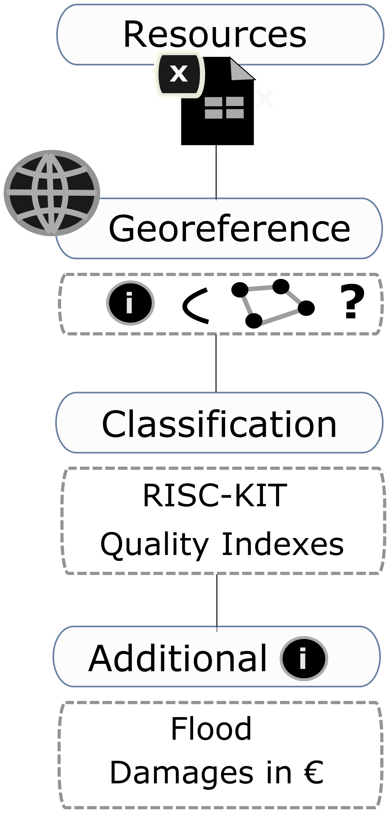
The project's partners provided information on storms that generated floods and impacts in their countries. In some cases, the identified events were found to be part of a cluster of storms. In those cases, they were included as a single entry in the database, but a flag was added to account for the nature of the storm. If necessary, any user can manually update the database based on their specific needs, following the standardized criteria described above, ensuring that the data are consistent and comparable. The final product is structured around three components, the guidelines, the polygons, and the resources, with each containing information and/or data (Fig. 1). The guidelines were implemented to provide potential, even non-expert, users with clear information on key aspects of the database, such as the rationale behind the product, the definitions of the different components and items (e.g. how a “storm” or “test case” is defined), and the sources of information and their characteristics. This can support the proper and coherent use of the dataset. A future development could be the construction of a GUI to allow direct on-screen data addition through georeferencing and databasing online tools. Therefore, the guidelines comprise a document providing the content and structure of the organized collection of spreadsheets. Moreover, the guidelines document includes instructions on how to query and retrieve the necessary information from the spreadsheets for the users' purposes. The polygons and resources are described in the next paragraphs.
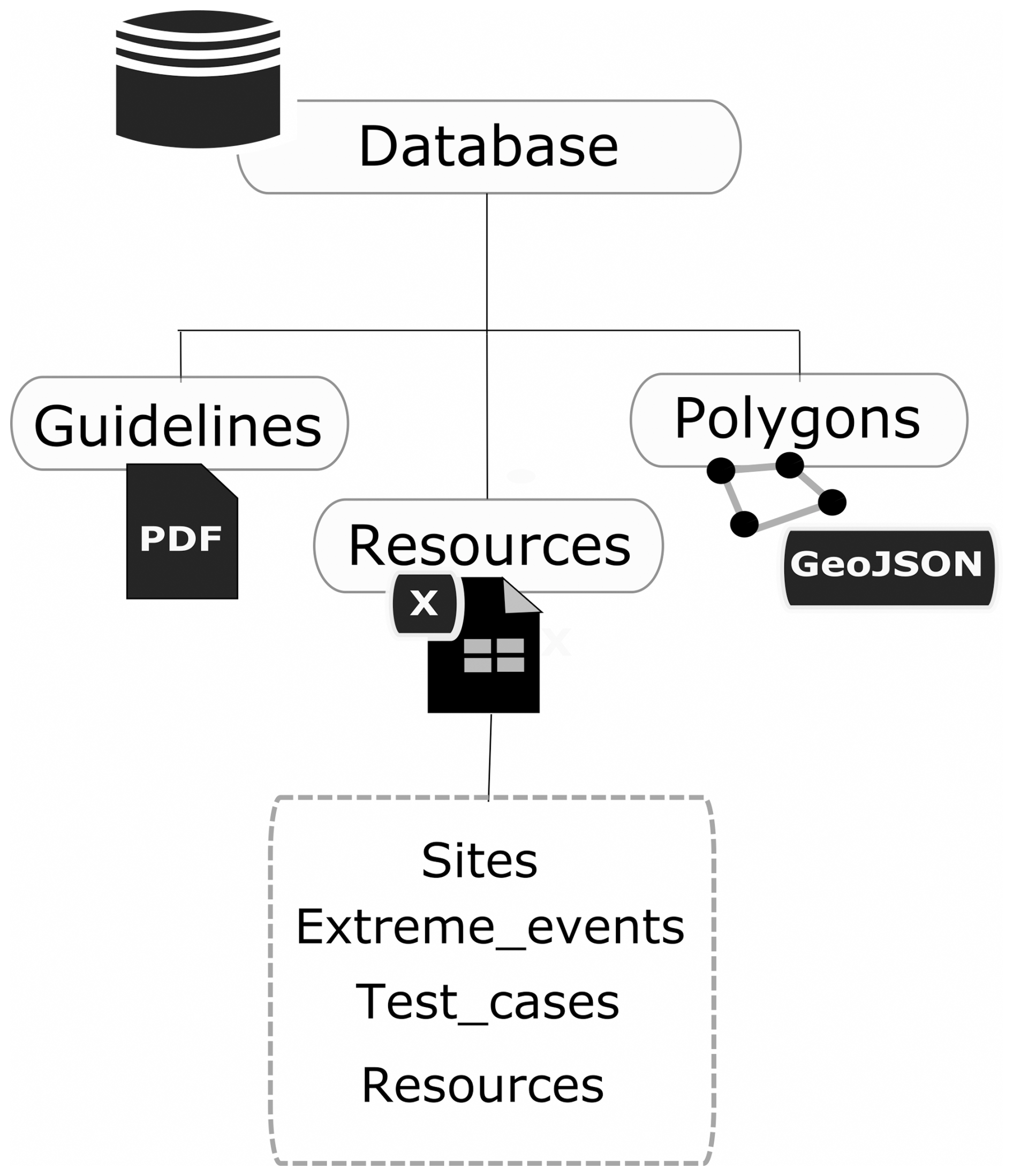
In the framework of this work, a “resource” is any digital or paper-based source of information that provides details, descriptions, images, or any material related to extreme coastal storms. The database benefits from the information included in the existing resources and provides all of the available sources categorized according to the type of resource (e.g. scientific reports and media) and topic (e.g. weather, hydrodynamics, and impacts).
2.1 Polygons
The polygons, provided in GeoJSON format, define the area of interest (AoI) for each site (26 sites; Fig. 2). The selection and definition of the sites are intended to represent different coastal regions (Vousdoukas et al., 2016a; Fernández-Montblanc et al., 2019) and, thus, the heterogeneity of the European coastlines as comprehensively as possible. Furthermore, the selection of the sites was carried out considering events that were able to generate considerable coastal floods and impacts.
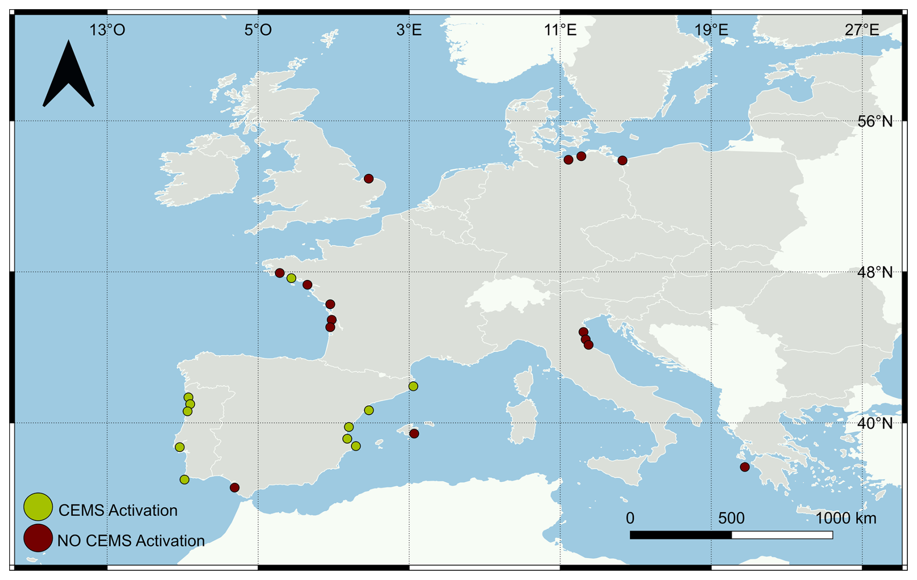
Figure 2Distribution of the 26 sites included in the ECFAS database of resources. Different colours indicate CEMS activation (green) or no CEMS activation (red) at the sites for the considered storms. Publisher's remark: please note that the above figure contains disputed territories according to the United Nations.
Entries were not pre-filtered based on a coastal flood extent threshold, as done for other databases, nor on the basis of an impact threshold (e.g. economic losses or fatalities) (Paprotny et al., 2024b). Some of these sites experienced flooding due to different storm events, and some storm events impacted more than one site across different countries. Therefore, a test case was defined as a site hit by an extreme meteo-marine event at a given moment. The database contains 28 test cases. The polygons were defined based on the assessment of the areas affected by coastal flood events following the criteria listed below:
-
If the area of interest of the activation from the CEMS Rapid Mapping Service was available, it was considered.
-
In areas where there was no Rapid Mapping Service activation information, the polygon extension was defined based on publicly available information related to the reported impacts and flood extent.
In both cases, if impacts were reported over a vast area, a sub-area was selected, corresponding to the portion of the territory with the larger number of reported impacts.
2.2 Resources
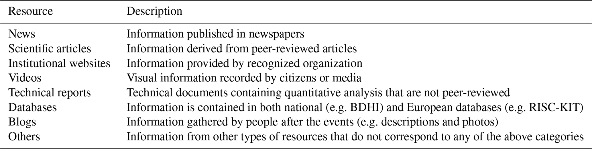
The resources component of the ECFAS database contains information about sites, extreme meteo-marine events, test cases, and available resources for information retrieval (Fig. 1). The spreadsheets link the “Fields” category to allow for cross-referencing and easy reading as well as the possible compilation of new data. This guarantees that the database is a simple tool that could accommodate changes, making it a living tool. The “Sites” spreadsheet contains information indicating the country and the regional marine domain as well as a cross-reference to the corresponding polygon that defines each site. The “Extreme Events” spreadsheet collects information regarding the characteristics of the coastal events, such as their official name (e.g. given by public meteo-services, any specialized agency, or by the press or meteo-websites), whether an event belongs to a cluster of storms (i.e. a sequence of storm events occurring on successive days and affecting large portions of European coastlines), the maximum wave height (retrieved from the literature), and the total water level (i.e. considering the contribution of ocean circulation, steric sea level, tides, storm surges, and waves; Irazoqui Apecechea et al., 2023). For each extreme event, impacts are also registered following the categories defined by the nomenclature of the RISC-KIT database, such as impacts on population, environment, economy, buildings, and infrastructure (Ciavola et al., 2018). The “Resources” spreadsheet organizes a collection of sources that are cross-linked to the corresponding storm event and site. The types of resources considered to gather the information are presented in Table 1.
Blogs and news have been included as a source of information, as they have been proven effective with respect to providing information on the location of the impacts and consequences related to coastal storms (Tschoegl et al., 2006; Santos et al., 2014). However, it is necessary to consider possible biases due to certain types of resources that could misrepresent specific impacts. For example, newspapers and media generally focus on urbanized coasts, emphasizing the impacts on population and infrastructure assets (representing accounting, threshold, and geography biases; Gall et al., 2009), whereas impacts on natural beaches are generally overlooked (Sancho-García et al., 2021). Similar considerations can be applied to information retrieved from blogs and/or social media. However, there are several reasons why newspapers are considered a primary source of information: they cover local events and occurrences with specific and frequent information; the same event is usually reported in different newspapers, making it possible to have a variety of resources and, thus, allowing for comparison; newspapers archives are usually maintained through time and are accessible; and newspaper information could be the only available source of information for historical events (La Red, 2013; Santos et al., 2014). Sancho-García et al. (2021) used news to assess the impact of extreme events at a regional level in Spain and found that these resources, even if they could lead to some bias, offer a quick assessment of the economic and physical damage intensity and distribution and also provide essential information to identify the location of hotspots.
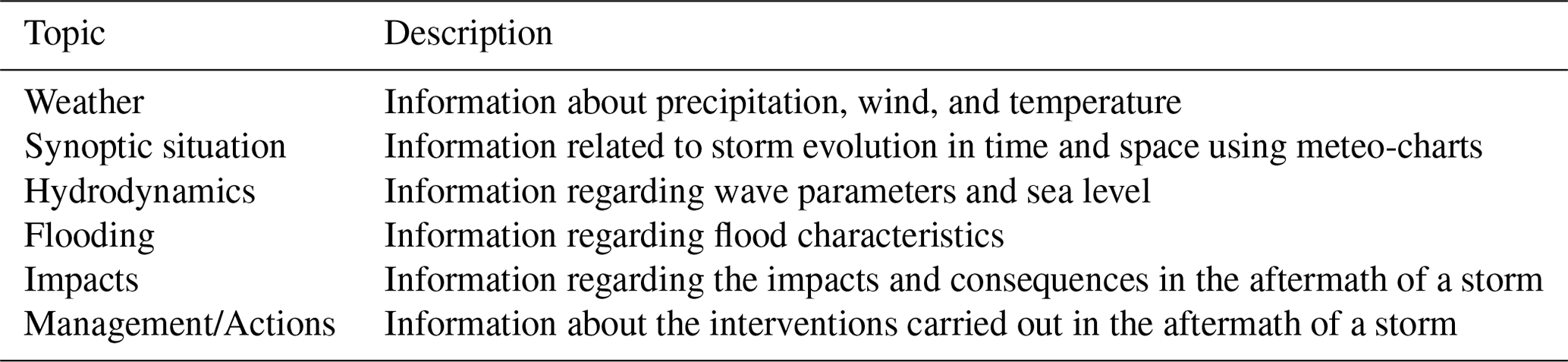
The polygons, provided in GeoJSON format, define the AoI for each site (26 sites; Fig. 2). The information retrieved from the resources covers one or several topics, such as weather, synoptic situation, and hydrodynamics, depending on the case. The topics were categorized following Table 2.
The resources were carefully quality (cross-)checked, and the hydrodynamic information of each event was retrieved from (only) institutional and reliable resources, such as (peer-reviewed) scientific articles and/or technical reports/institutional websites of responsible entities (e.g. national or local public institutions) and/or reliable databases (e.g. RISC-KIT database). The resources collected in the spreadsheet can be filtered by event, site, resource type, or topic. Resource retrieval by users is facilitated by the addition of hyperlinks and complete URLs.
Table 3 shows the database statistics for each country in terms of the number of sites, events, test cases, and resources. France and Spain represent the majority of resources (29 and 28, respectively) due to the higher number of attributed test cases (6 and 7, respectively). On the other hand, fewer resources are related to the test cases in Germany and Poland (5 and 0, respectively), even though both areas were hit by the same extreme storm event. In this case, such a difference in the number of resources may be a consequence of the language used in each country to release information about the event (English vs. the local language).
Table 3Statistics on spatial and temporal coverage. The table considers only the resources that are associated with one country, excluding those giving general information about the storm or referring to more than one country.
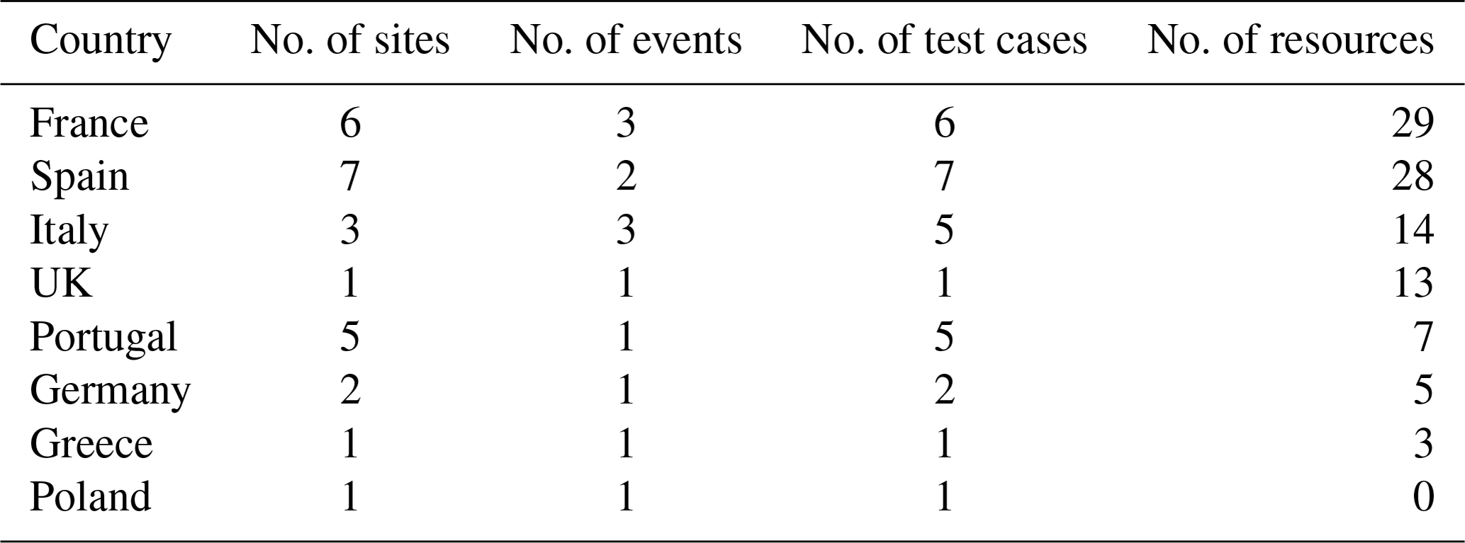
Another aspect to be considered is possibly associated with the storm's name, which often changes according to the affected country. A single event impacting different areas can be named differently; for instance, a storm that was referred to as Christina in France was named Hercules in Portugal.
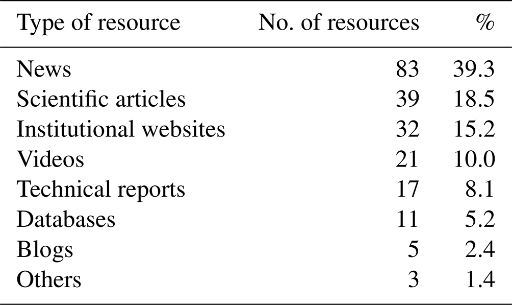
The number of collected observations (occurrences) substantially differs for each type of resource (Table 4). News is the resource accounting for more than one-third of all collected observations (relative frequency of 39.3 %).
Table 4Number of resources collected per resource type and their relative frequency.
The distribution of the types of resources per country (Fig. 3) was analysed, considering resources referring solely to the affected country. The most common resources concerning the seven storm events registered in southern European countries (Portugal, Spain, Italy, and Greece) are “News” and “Videos”. Little information was found in “Technical reports”, “Scientific articles”, and “Institutional websites”, even though the seven events included storms of a certain magnitude, such as the storm Gloria in Spain in 2020 (Amores et al., 2020; Sanuy et al., 2021) and storm Vaia in Italy in 2018 (Cavaleri et al., 2019; Ferrarin et al., 2020; Morucci et al., 2020). Storm events that affected France and the UK generally had a more significant impact if compared with southern Europe.
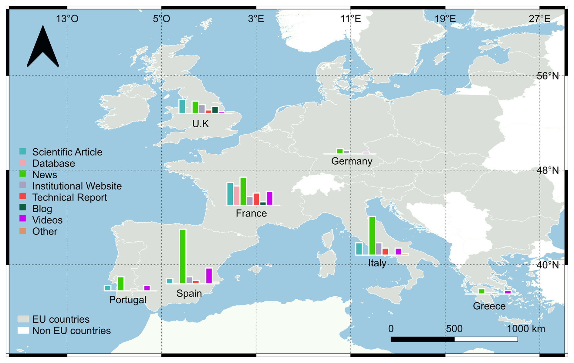
Figure 3Distribution of the resource types per European country contained in the ECFAS database of resources. The histograms represent the frequencies in relation to the total number of resources. Poland was excluded because no resources were found for this country. Publisher's remark: please note that the above figure contains disputed territories according to the United Nations.
The number of observations (occurrences) of each topic and the percentages of resources per topic are shown in Table 5. Note that each resource can refer to more than one topic. Due to the more significant presence of News as a resource type – responsible for 39.3 % of the observations retrieved by all considered resources (Table 4) – the most covered topics are “Impacts” and “Flooding”, while more technical topics, such as “Hydrodynamics”, “Synoptic”, and “Weather” are less frequent.
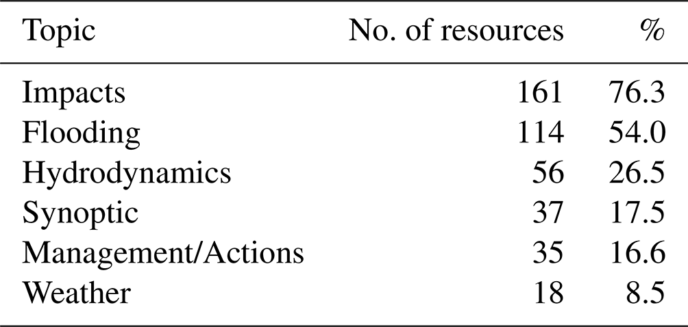
Resource information “Management/Actions” that refers to response actions taken after events are not very frequent considering the number of events accounted for in the database, which may indicate little disclosure of the information about the costs incurred and the measures taken after the events. Moreover, the news tends to report the impacts during or in the immediate aftermath of the event because this strikes most listeners' interest. The recovery phase could be slow and take time and is, therefore, less interesting or catchy. This is one of the main reasons why the news does not always precisely quantify the damages (direct and indirect) incurred following the occurrence of an event, nor does it report on recovery actions unless the event is of such a magnitude that it remains in the political and cultural “agenda” for a longer period.
3.1 The example of storm Christina: different countries in the path of one single event
Storm Christina affected several areas across Europe from 5 to 7 January 2014. The event is present in other databases (RISC- KIT, SurgeWatch, and Base de Donnèes Historique sur les Inondations) due to the severe consequences recorded following the storm's passage. The extensive attention given to the storm in Portugal and France enabled the collection of a significant number of resources that were added to the database. A total of eight test cases were defined: three test cases in France and five in Portugal. As stated previously, the event was named differently in the two countries: Hercules in Portugal and Christina in France. The latter name was given by the University of Berlin, the institution that started to establish names for low- and high-pressure systems back in 1954 (Kotroni et al., 2021). In contrast, Hercules was the name given by The Weather Channel, a North American private TV channel (Santos et al., 2014). The information related to storm Christina in France and Portugal is shown in Fig. 4. According to the types of resources (Fig. 4a), neither the “Blogs” nor “Others” category is present in the database for this storm. Resources collected from the “Database” and Institutional websites categories were related to the passage of Christina in France only. The Scientific articles resource type was found for Portugal only. Furthermore, the percentage of Technical reports was higher in France (8.3 %) than in Portugal (2.8 %), possibly because there are institutional responsibilities that request report provision in the former country.
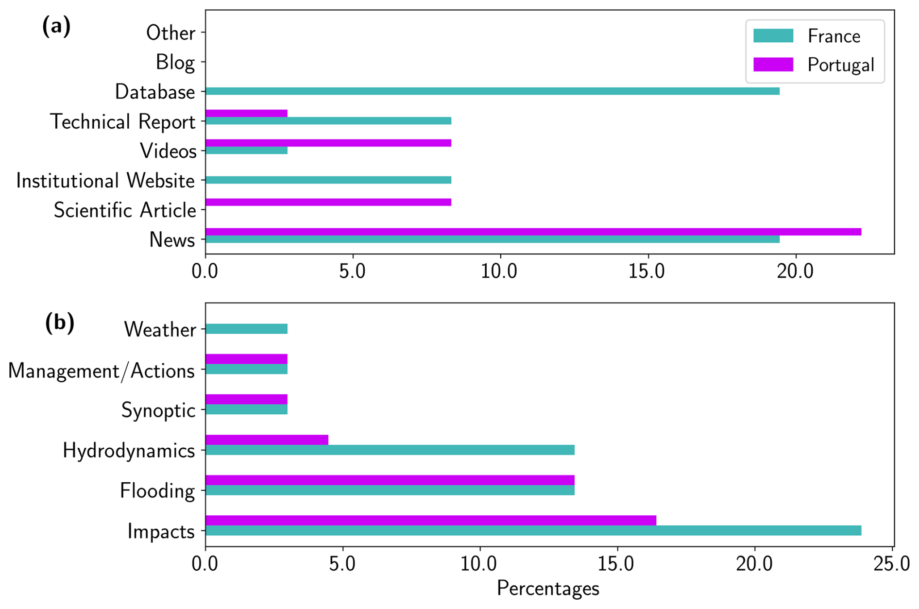
Figure 4Percentage of occurrence for each type (a) and topic (b) of the resources collected after the passage of storm Christina in France (green) and Portugal (magenta).
The differences detected in the types of resources publishing material about the same storm event among countries might be an indicator of the number and type of institutions covering this kind of information. In Portugal, the event information seems to be provided by academic institutions, whereas in France, it is provided by government institutions at different levels (e.g. regional and national). These differences could be due to (1) the number of coastal assets that are exposed to storm events or (2) the presence of efficient coastal protection. In countries where the coastline is vulnerable and heavily occupied, storms can generate large impacts and economic damages that are then reported. In addition, there are countries in which the administration performs a systematic collection of information on storm impacts in order to implement effective coastal risk management (e.g. for the Emilia-Romagna region in Italy, see Armaroli et al., 2012). The availability of scientific papers could be an indicator of the presence of specialized research teams in universities or research entities that perform the collection of information and analysis of the effect of extreme events on coastal areas. Regarding the topics published by the resources (Fig. 4b), Weather is the only topic exclusively addressed in France. All other topics are present with a similar frequency (Management/Actions and Synoptic) or more frequently present in the French resources (Hydrodynamics, Flooding, and Impacts).
Impact databases can be used for several purposes, such as building statistics, evaluating the level of risk for specific areas, implementing effective protection actions, or reconstructing past events that caused significant socioeconomic impacts (Paprotny et al., 2024a). Within the framework of the ECFAS project, the database supported the calibration and validation of coastal flood extent and flood impact modelling at the European scale. The in-depth analysis of the information retrieved from the resources (quantitative, qualitative, or visual data) supported the geolocation of flood and impact markers, hereafter called the “database of markers” (DBM), that were used to generate tailored coastal flood and impact catalogues. These catalogues represent (i) a series of flood maps covering most of the European coasts, built considering different hazard scenarios, and (ii) layers at a pan-EU scale with information on the flood impact on the population and other assets, such as buildings and roads, produced using the flood maps of the flood catalogue (Duo et al., 2022a; Le Gal et al., 2022b; Montes et al., 2022; Le Gal et al., 2023). The retrieved information on flood markers was used to validate the flood simulations implemented with the LISFLOOD-FP model (Le Gal et al., 2022a, 2024) that was then used to build the flood catalogue. The economic-loss-related information (i.e. damage to buildings and infrastructure repair costs) and affected population were qualitatively and, where possible, quantitatively compared with the impact estimated with an algorithm for impact assessment developed within the framework of the ECFAS project (Duo et al., 2022b) and that was used to build the impact catalogue (Duo et al., 2025). The DBM characteristics are briefly described in the following to show how the information collected on flooding events and impacts could be analysed to build a reliable baseline for risk studies and to show the importance of implementing consistent, coherent, comprehensive, and hazard-specific databases (i.e. for coastal flooding).
4.1 From the database to impact identification
The methodology adopted to generate the DBM is illustrated in Fig. 5. The resources in the ECFAS DB spreadsheets were filtered by test case and analysed (by searching for all of the information related to the floods and impacts caused by a specific storm at a specific site). Each resource was deeply analysed in terms of the content and quality of the information. Flooded areas and impacts were identified and geolocated (when possible). If a specific location was not identified, a generic location in the area of interest was assigned. Each georeferenced flooded area and impact constituted a marker. All of the identified markers were stored in shapefiles, and the related information was stored in an Excel spreadsheet. In addition to the coordinates' position, some extra information to describe and characterize the markers was retrieved from the resources and was incorporated as attribute fields in the shapefiles. Each marker was classified by the following: (i) an impact category and subcategory following those adopted in the RISC-KIT project (Viavattene et al., 2015); (ii) quality indexes and additional information regarding flood presence and economic damages; (iii) a resource identifier specifying where the information was retrieved; and (iv) any other information that could be helpful to describe the marker.
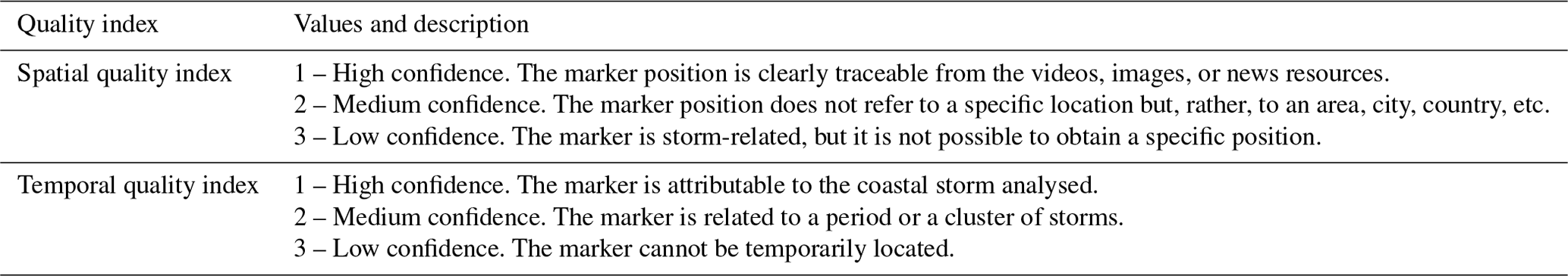
Quality indexes were adopted to control the temporal and spatial precision of each marker, as the information provided from different resources may not always be precise. The uncertainty affects the accuracy of the geolocation and the associated information's reliability. Each quality index follows a three-level classification, with 1 being the maximum quality and 3 being the minimum. The criteria adopted to assign the categories are shown in Table 6. The overall reliability of the retrieved information was evaluated during the search and collection phase while building the database of resources.
In addition, in the attribute table, a field for economic damage is added, providing, when possible, the damage costs (in EUR) caused by the event. Finally, when it was possible to assign specific information on the characteristics of the flood, fields were included providing the following: (i) a flag indicating the availability of specific flood-related information, (ii) the reported or assessed flood depth (in metres), and (iii) the level of confidence on the evaluation of the flood depth (low, medium, or high). When not directly reported, the flood depth evaluation was conducted by analysing pictures, videos, or any material that could support the analysis. A few examples are shown in Fig. 6. Next, the confidence level of the evaluation was applied depending on the presence of a reference scale (e.g. a person standing in the picture). Finally, the data description information was associated with the DBM to indicate additional information that could not be described in the other fields.
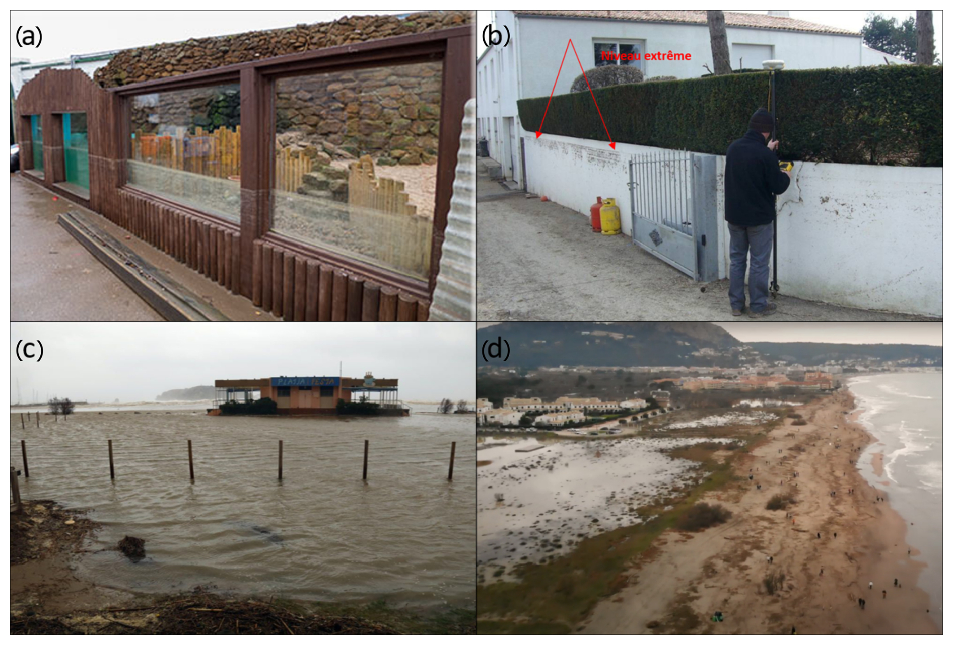
Figure 6Examples of the level of confidence associated with the flood depth: panels (a) and (b) show a high level of confidence (clear spatial references in the pictures), panel (c) shows a medium level of confidence (some reference in the picture), and panel (d) shows a low level of confidence (no clear reference in the picture). References for the images are as follows: (a) https://www.sealsanctuary.co.uk/pressrel09102014hsls.html (last access: 2 January 2025); (b) http://infoterre.brgm.fr/rapports/RP-58261-FR.pdf (last access: 23 February 2025) (Pedreros et al., 2010; last access: 2 January 2025); (c) https://www.diaridegirona.cat/baix-emporda/2020/01/21/temporal-esborra-les-platges-l-48749485.html (last access: 2 January 2025); (d) https://www.youtube.com/watch?v=oQ5ME3pImmo&list=UUUP8KKlJgWf6JTHg-NNKN9g&ab_channel=CostaBravaVibes (last access: 2 January 2025).
4.2 Flood and impact markers in the ECFAS case studies
A total of 213 markers were retrieved for 28 test cases using the 211 currently available resources. The number of markers recovered from each type of resource is shown in Table 7.
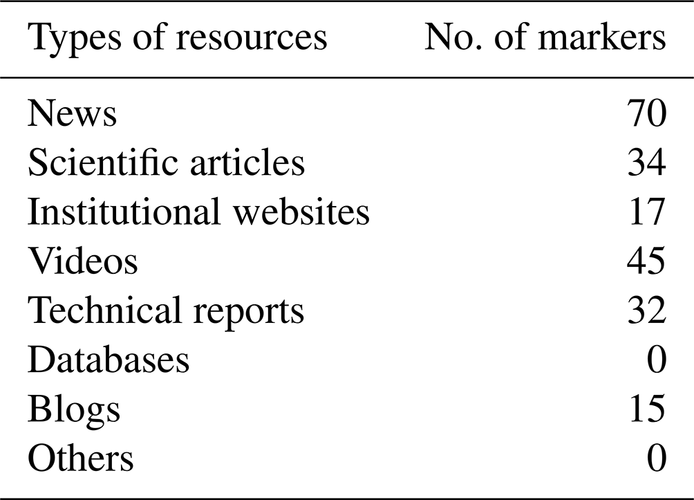
The type of resource that proportionally resulted in more marker occurrences was Blogs (from 5 blogs reported in Table 4, 15 markers were obtained), followed by Technical reports (32 markers were established from the 17 technical reports reported in Table 4) and Videos (45 markers were established from the 21 videos reported in Table 4). Neither the Database or Others resource types generated markers. The analysis of markers' spatial and temporal quality indexes is presented in Fig. 7a and b. The resources mainly produced georeferenced points with high spatial and temporal confidence; the points with low confidence were less frequent.
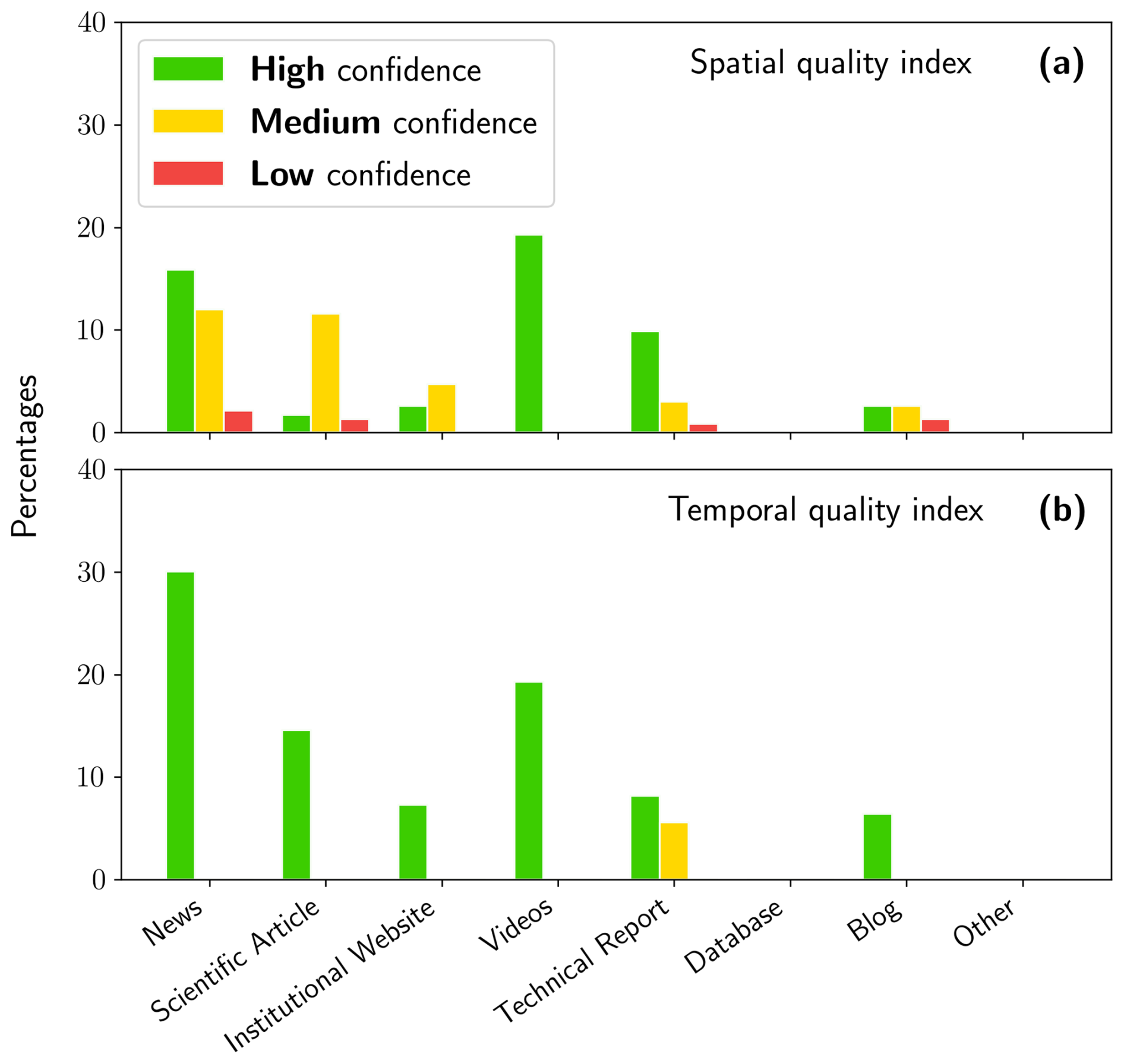
Figure 7Percentage of occurrence of the high (green), medium (yellow), and low (red) confidence values per resource type for the (a) spatial quality index and (b) temporal quality index.
The markers retrieved from Scientific articles mostly show medium spatial confidence (Fig. 7a). Scientific articles about coastal storm events usually study the generation of the event and the associated hydrodynamics, which infrequently produces georeferenced information (e.g. wave height or wind velocity from a given buoy or station). In the case of articles publishing information about coastal storm impacts and/or storm impact assessment, the images and information provided focus on the processes rather than on their precise location. The Technical report resource type shows that the geolocations are relatively less defined in time than the other types of resources. Private companies usually produce technical reports upon request from regional or national authorities following one or several damaging events. However, such consultancies imply costs, and the physical and economic damages are assessed after a (long) period of bad weather. Therefore, the markers retrieved from technical reports are precisely localized in space but less so in time. The most reliable resource type is Videos, which shows high confidence with respect to the spatial and temporal quality indexes. The markers retrieved from Blogs and Institutional websites are of high, medium, and low spatial confidence (Fig. 7a and b); this may be due to the use of common local names to identify the position of impacts and flood extent, making this information difficult to interpret for a user not familiar with the area.
Le Gal et al. (2023) implemented a pan-European catalogue of flood maps (water depth and velocities) within the framework of the ECFAS project, considering different storm scenarios. To build the catalogue, the flood model, as well as the simulated floods obtained using the LISFLOOD-FP model (Bates and De Roo, 2000; Bates et al., 2010) forced with hindcasts of total water levels (Melet et al., 2021), was validated using the information included in the ECFAS database, considering 12 test cases for which observations of the actual extent of storms impact were available, i.e. satellite-derived flood maps and in situ flood markers from the DBM (see Fig. 1 and Table 1 of Le Gal et al., 2023). Depending on the availability of satellite imagery, satellite-based mapping in CEMS is carried out some time after the peak of the event; therefore, it is not always able to capture the maximum extent of the flood. This limitation may produce a bias in the estimation of the accuracy of the model. However, satisfactory agreement was found between the model results and the observed flooded areas and markers, showing the value of measured and observed flood information for model validation. For validation purposes, Le Gal et al. (2023) defined a “hit” when the model was able to flood the grid cell(s) enclosing the identified marker(s). The hit ratio was defined as “the number of markers that were hit compared to the total number of markers available for the test case”. Among the analysed test cases, five have a marker hit ratio of 100 %. For the other test cases, one has a hit ratio of 94.11 %, whereas the remaining cases show values of 50 %, 25 %, and 0 %, respectively. For two test cases, no flood markers could be obtained from the database resources to perform the validation.
The DBM was also exploited to validate the impact assessment implemented in the ECFAS project on the basis of the flood catalogue from Le Gal et al. (2023). The impact assessment methodology combines object-based and probabilistic evaluations to give uncertainty estimates for economic damage assessment (Duo et al., 2025). The approach was applied to 16 test cases of the ECFAS DB that represented 10 extreme events able to considerably affect 15 European coastal sites (refer to Table 1 and Fig. 1 of Duo et al., 2025). Three reference cases were then selected for validation purposes, i.e. to compare the modelled impacts with reported economic damages (Xynthia in France, 2010; Xaver in UK, 2013; Emma in Spain, 2018). The findings demonstrate that the ECFAS DB provides valuable information to retrieve flood and impact markers for a model's validation. Specifically, the information retrieved from the database was georeferenced and characterized by analysing the different sources of each event and was then categorized according to several impact categories. The information contained in the database also made it possible to assign quality indexes in relation to the type of resource. The type of information retrieved was flood and impact markers, local damage (in EUR), and other additional information that could be significant for the validation of the models (Le Gal et al., 2023; Duo et al., 2025). These data supported the findings that the impact model from Duo et al. (2025) is more accurate than traditional grid-based approaches.
The ECFAS database, including the guidelines and the GeoJSON files, is available for download from Zenodo: https://doi.org/10.5281/zenodo.6538416 (Souto-Ceccon et al., 2021).
A properly designed database provides access to up-to-date and accurate information that users should be able to easily consult. Therefore, an appropriate database design is essential to achieve the objectives. Users are more likely to use a database that meets their needs and can quickly adapt to changes. A database of resources such as the one presented in this paper is coast-specific, follows defined rules and definitions, and can be easily improved and/or updated by adding new information. Furthermore, resources are provided without data manipulation, so the user can apply different methodologies and criteria to extract and use the data. Ideally, a database for the assessment of the impact of extreme events should include all of the information associated with risk definition, from the hazard characteristics to the exposure and vulnerability, coping capacity, and resilience of the affected area as well as information on the impacts and recovery actions. The implementation of a comprehensive database could be challenging, as it should include a large amount of information and be designed according to different purposes (e.g. insurance, risk assessment, and emergency management). Furthermore, the standardization of a data definition and collection and a common classification scheme and terminology might not be available nor applied (Koç and Thieken, 2018). The ECFAS awareness system for coastal floods at the pan-EU scale was designed using a bottom-up approach, and comprehensive user consultation was carried out to design the system. The ECFAS DB includes biases due to its characteristics, but it was not built by filtering information according to pecuniary losses nor by the severity of the event (threshold bias). However, given that it is defined as a database that collects information only if a coastal flood is reported, it could over-represent densely populated, built-up, and easily accessible areas (geography bias) (Gall et al., 2009).
The ECFAS database is a collection of resources. Currently the most similar database is the French Base de Données Historique sur les Inondations (BDHI). The BDHI lists and describes flood events from different (e.g. river or coastal) sources that have occurred in French territory over the past centuries and up to the present day. The archived documents can be in the form of a press article, hydrological report, meteorological report, historical study, etc. However, the BDHI is a national tool and can only be accessed by authorized users. In contrast, the ECFAS DB covers different European countries and is an open-access tool that can be exploited, as is, by any user; it can also be updated or complemented with new events according to the interest of different users' communities and purposes (e.g. coastal flood risk management, early-warning system and emergency, and model validation). Via labelling with unique identifiers, the ECFAS DB allows for a quick and consistent retrieval of all of the resources associated with an event or test case. Another relevant characteristic is that the ECFAS DB groups the resources per storm event, so that it is possible to immediately establish if the same storm affected more than one country or location. This characteristic of the ECFAS DB is especially important if supranational/transboundary studies (e.g. at the pan-EU level) have to be carried out.
The ECFAS DB has been built to minimize the biases that could affect databases (Gall et al., 2009). Although intrinsic biases may be present in the sources, these are not amplified or newly introduced in the database considering the method used for its implementation and the inclusion criteria. Therefore, given the very limited data interpretation, it can be easily scaled and updated using information from different (European and beyond) countries and storms with different extents. The process requires a certain amount of time, as the resources have to be retrieved and quality checked. Additionally, the guidelines will support the future update and use of the database.
The countries with the lowest number of retrieved resources are Greece, Germany, and Poland; this could be due to a language-related issue or to the different names given to the same storm events. This might introduce biases, affecting the geographical coverage and completeness of the database. Language barriers can be addressed, for example, through collaboration with translation services or local institutions, research centres, or universities working on coastal flood risk that could support the identification and consequent translation of local information.
The distribution of the resource types per country seems to indicate that more resource types were observed in France and the UK, with a higher presence of Technical reports, Scientific articles, and Institutional websites. The differences between the types of resources can also be observed by comparing those provided for storm Christina, which affected Portugal and France. Therefore, the higher presence of these resource types could be related to a broad awareness of coastal flooding events or to the significance of their impacts at a national level. For example, it is worth noting that, in February 2010, France experienced one the most critical European coastal flood events of recent years (Kolen et al., 2013), in terms of physical and economic damages and casualties, certainly raising people's consciousness, and the UK is significantly and frequently exposed to such events (Haigh et al., 2016), which supports investment in national and regional initiatives. The ECFAS DB could allow for other evaluations to be carried out, such as investigating if an “awareness pattern” exists across different countries in relation to national and European policies. The advantages and applications of the database were assessed during the ECFAS project. Georeferenced points (markers) for each test case were retrieved from its corresponding resources, following a specific and replicable methodology to use the information to validate the results obtained from impact and flood models. The same dataset and its application to identify flood markers could be useful to improve the available flood damage curves at the pan-EU scale (e.g. Jongman et al., 2012) or to build new ones for specific cases or countries. However, the identification of georeferenced markers from the database is not always possible due to the description of the impacts provided in the resources, which can be too generic, not contain clear pictures, or use jargon with respect to the localities or assets affected.
PSC: paper and research conceptualization, data analysis, and writing and editing of the manuscript. JM: research conceptualization, data analysis, and writing and editing of the manuscript. ED: research conceptualization and editing of the manuscript. PC: discussion of results, editing of the manuscript, provision of funding, and supervision of the PhD thesis. TFM: research conceptualization and editing of the manuscript. CA: discussion of results, co-supervision of PhD thesis, writing and editing of the manuscript, and coordination of exchange with the ECFAS project.
The contact author has declared that none of the authors has any competing interests.
Publisher's note: Copernicus Publications remains neutral with regard to jurisdictional claims made in the text, published maps, institutional affiliations, or any other geographical representation in this paper. While Copernicus Publications makes every effort to include appropriate place names, the final responsibility lies with the authors.
The authors are grateful to Bruna Alves Rodriguez for her contribution to improving the readability of the original version of the paper.
This work was supported by the EU H2020 ECFAS project (a proof-of-concept for the implementation of a European Copernicus coastal flood awareness system, https://www.ecfas.eu, last access: 23 February 2025) financed by the Horizon 2020 Research and Innovation programme under grant no. 101004211.
This paper was edited by Sebastiano Piccolroaz and reviewed by two anonymous referees.
Amores, A., Marcos, M., Carrió, D. S., and Gómez-Pujol, L.: Coastal impacts of Storm Gloria (January 2020) over the north-western Mediterranean, Nat. Hazards Earth Syst. Sci., 20, 1955–1968, https://doi.org/10.5194/nhess-20-1955-2020, 2020.
Armaroli, C., Ciavola, P., Perini, L., Calabrese, L., Lorito, S., Valentini, A., and Masina, M.: Critical storm thresholds for significant morphological changes and damage along the Emilia-Romagna coastline, Italy, Geomorphology, 143, 34–51, 2012.
Bates, P. and De Roo, A.: A Simple Raster-Based Model for Flood Inundation Simulation, J. Hydrol., 236, 54–77, https://doi.org/10.1016/S0022-1694(00)00278-X, 2000.
Bates, P. D., Horritt, M. S., and Fewtrell, T. J.: A Simple Inertial Formulation of the Shallow Water Equations for Efficient Two-Dimensional Flood Inundation Modelling, J. Hydrol., 387, 33–45, https://doi.org/10.1016/j.jhydrol.2010.03.027, 2010.
Cavaleri, L., Bajo, M., Barbariol, F., Bastianini, M., Benetazzo, A., Bertotti, L., Chiggiato, J., Davolio, S., Ferrarin, C., Magnusson, L., Papa, A., Pezzutto, P., Pomaro, A., and Umgiesser, G.: The October 29, 2018 storm in Northern Italy – an exceptional event and its modeling, Prog. Oceanogr., 178, 102178, https://doi.org/10.1016/j.pocean.2019.102178, 2019.
Ciavola, P., Harley, M. D., and Den Heijer, C.: The RISC-KIT storm impact database: A new tool in support of DRR, Coast. Eng., 134, 24–32, 2018.
Di Baldassarre, G., Nohrstedt, D., Mård, J., Burchardt, S., Albin, C., Bondesson, S., Breinl, K., Deegan, F. M., Fuentes, D., Lopez, M. G., Granberg, M., Nyberg, L., Nyman, M. R., Rhodes, E., Troll, V., Young, S., Walch, C., and Parker, C. F.: An integrative research framework to unravel the interplay of natural hazards and vulnerabilities, Earth's Future, 6, 305–310, 2018.
Duo, E., Montes Pérez, J., Le Gal, M., Souto Ceccon, P. E., Cabrita, P., Fernández Montblanc, T., and Ciavola, P.: ECFAS Pan-EU Impact Catalogue, D5.4 – Pan-EU flood maps catalogue – ECFAS project (GA 101004211), https://www.ecfas.eu (last access: 23 February 2025), (1.2), Zenodo [data set], https://doi.org/10.5281/zenodo.6778864, 2022a.
Duo, E., Montes-Pérez, J., and Souto-Ceccon, P. E.: ECFAS Impact Tool, D5.3 – Algorithms for impact assessment – ECFAS project (GA 101004211), Zenodo [code], https://doi.org/10.5281/zenodo.5809296, 2022b.
Duo, E., Montes, J., Le Gal, M., Fernández-Montblanc, T., Ciavola, P., and Armaroli, C.: Validated probabilistic approach to estimate flood direct impacts on the population and assets on European coastlines, Nat. Hazards Earth Syst. Sci., 25, 13–39, https://doi.org/10.5194/nhess-25-13-2025, 2025.
Fernández-Montblanc, T., Vousdoukas, M., Ciavola, P., Voukouvalas, E., Mentaschi, L., Breyiannis, G., Feyen, L., and Salamon, P.: Towards robust pan-European storm surge forecasting, Ocean Model., 133, 129–144, 2019.
Ferrarin, C., Valentini, A., Vodopivec, M., Klaric, D., Massaro, G., Bajo, M., De Pascalis, F., Fadini, A., Ghezzo, M., Menegon, S., Bressan, L., Unguendoli, S., Fettich, A., Jerman, J., Ličer, M., Fustar, L., Papa, A., and Carraro, E.: Integrated sea storm management strategy: the 29 October 2018 event in the Adriatic Sea, Nat. Hazards Earth Syst. Sci., 20, 73–93, https://doi.org/10.5194/nhess-20-73-2020, 2020.
Gall, M., Borden, K. A., and Cutter, S. L.: When do losses count? Six fallacies of natural hazards loss data, B. Am. Meteorol. Soc., 90, 799–810, 2009.
Guzzetti, F. and Tonelli, G.: Information system on hydrological and geomorphological catastrophes in Italy (SICI): a tool for managing landslide and flood hazards, Nat. Hazards Earth Syst. Sci., 4, 213–232, https://doi.org/10.5194/nhess-4-213-2004, 2004.
Haigh, I. D., Wadey, M. P., Wahl, T., Ozsoy, O., Nicholls, R. J., Brown, J. M., Horsburgh, K., and Gouldby, B.: Spatial and temporal analysis of extreme sea level and storm surge events around the coastline of the UK, Scientific Data, 3, 1–14, 2016.
Haigh, I. D., Ozsoy, O., Wadey, M. P., Nicholls, R. J., Gallop, S. L., Wahl, T., and Brown, J. M.: An improved database of coastal flooding in the United Kingdom from 1915 to 2016, Scientific Data, 4, 1–10, 2017.
Hall, J., Arheimer, B., Aronica, G. T., Bilibashi, A., Boháč, M., Bonacci, O., Borga, M., Burlando, P., Castellarin, A., Chirico, G. B., Claps, P., Fiala, K., Gaál, L., Gorbachova, L., Gül, A., Hannaford, J., Kiss, A., Kjeldsen, T., Kohnová, S., Koskela, J. J., Macdonald, N., Mavrova Guirguinova, M., Ledvinka, O., Mediero, L., Merz, B., Merz, R., Molnar, P., Montanari, A., Osuch, M., Parajka, J., Perdigão, R. A. P., Radevski, I., Renard, B., Rogger, M., Salinas, J. L., Sauquet, E., Šraj, M., Szolgay, J., Viglione, A., Volpi, E., Wilson, D., Zaimi, K., and Blöschl, G.: A European Flood Database: facilitating comprehensive flood research beyond administrative boundaries, P. Int. Ass. Hydrol. Sci., 370, 89–95, 2015.
Hilker, N., Badoux, A., and Hegg, C.: The Swiss flood and landslide damage database 1972–2007, Nat. Hazards Earth Syst. Sci., 9, 913–925, https://doi.org/10.5194/nhess-9-913-2009, 2009.
Irazoqui Apecechea, M., Melet, A., and Armaroli, C.: Towards a pan-European coastal flood awareness system: Skill of extreme sea-level forecasts from the Copernicus Marine Service, Frontiers in Marine Science, 9, 1091844, https://doi.org/10.3389/fmars.2022.1091844, 2023.
Jones, R. L., Guha-Sapir, D., and Tubeuf, S.: Human and economic impacts of natural disasters: can we trust the global data?, Scientific Data, 9, 1–7, 2022.
Jongman, B., Kreibich, H., Apel, H., Barredo, J. I., Bates, P. D., Feyen, L., Gericke, A., Neal, J., Aerts, J. C. J. H., and Ward, P. J.: Comparative flood damage model assessment: towards a European approach, Nat. Hazards Earth Syst. Sci., 12, 3733–3752, https://doi.org/10.5194/nhess-12-3733-2012, 2012.
Koç, G. and Thieken, A. H.: The relevance of flood hazards and impacts in Turkey: What can be learned from different disaster loss databases?, Nat. Hazards, 91, 375–408, 2018.
Kolen, B., Slomp, R., and Jonkman, S.: The impacts of storm Xynthia February 27–28, 2010 in France: lessons for flood risk management, J. Flood Risk Manag., 6, 261–278, 2013.
Kotroni, V., Lagouvardos, K., Bezes, A., Dafis, S., Galanaki, E., Giannaros, C., Giannaros, T., Karagiannidis, A., Koletsis, I., Kopania, T., Papagiannaki, K., Papavasileiou, G., Vafeiadis, V., and Vougioulas, E.: Storm naming in the eastern mediterranean: Procedures, events review and impact on the citizens risk perception and readiness, Atmosphere, 12, 1537, https://doi.org/10.3390/atmos12111537, 2021.
La Red: The challenge of information sources. Project DesInventar, http://www.desinventar.net/data_sources.html (last access: 2 January 2025), 2013.
Lang, M., Coeur, D., Audouard, A., Oliver, M. V., and Pène, J.-P.: BDHI: a French national database on historical floods, in: vol. 7, 3rd European conference on flood risk management (FLOODrisk 2016), 17–21 October 2016, Lyon, France, p. 04010, https://doi.org/10.1051/e3sconf/20160704010, 2016.
Le Gal, M., Ciavola, P., Gastal, V., Fernandez-Montblanc, T., and Delbour, S.: Validated LISFLOOD-FP model for coastal areas, Deliverable 5.2 – ECFAS Project (GA 101004211), Zenodo [code], https://doi.org/10.5281/zenodo.5809290, 2022a.
Le Gal, M., Fernández Montblanc, T., Montes Pérez, J., Duo, E., Souto Ceccon, P. E., Cabrita, P., and Ciavola, P.: ECFAS Pan-EU Flood Catalogue, D5.4 – Pan-EU flood maps catalogue – ECFAS project (GA 101004211), Zenodo [code], https://doi.org/10.5281/zenodo.6778807, 2022b.
Le Gal, M., Fernández-Montblanc, T., Duo, E., Montes Perez, J., Cabrita, P., Souto Ceccon, P., Gastal, V., Ciavola, P., and Armaroli, C.: A new European coastal flood database for low–medium intensity events, Nat. Hazards Earth Syst. Sci., 23, 3585–3602, https://doi.org/10.5194/nhess-23-3585-2023, 2023.
Le Gal, M., Fernández-Montblanc, T., Montes Perez, J., Duo, E., Souto Ceccon, P., Ciavola, P., and Armaroli, C.: Influence of model configuration for coastal flooding across Europe, Coast. Eng., 192, 104541, https://doi.org/10.1016/j.coastaleng.2024.104541, 2024.
Magnan, Alexandre K. M., Oppenheimer, M., Garschagen, M., Buchanan, M. K., Duvat, V. K. E., Forbes, D. L., Ford, J. D., Lambert, E., Petzold, J., Renaud, F. G., Sebesvari, Z., van de Wal, R. S. W., Hinkel, J., and Pörtner, H.: Sea level rise risks and societal adaptation benefits in low-lying coastal areas, Sci. Rep., 12, 10677, https://doi.org/10.1038/s41598-022-14303-w, 2022.
Mazhin, S. A., Farrokhi, M., Noroozi, M., Roudini, J., Hosseini, S. A., Motlagh, M. E., Kolivand, P., and Khankeh, H.: Worldwide disaster loss and damage databases: A systematic review, Journal of Education and Health Promotion, 10, 329, https://doi.org/10.4103/jehp.jehp_1525_20, 2021.
Melet, A., Irazoqui Apecechea, M., Fernández-Montblanc, T., and Ciavola, P.: Report on the Calibration and Validation of Hindcasts and Forecasts of Total Water Level along European Coasts, Deliverable 4.1 – ECFAS project (GA 101004211), Zenodo [report], https://doi.org/10.5281/zenodo.6571778, 2021.
Montes, J., Duo, E., Souto, P., Gastal, V., Grigoriadis, D., Le Gal, M., Fernández-Montblanc, T., Delbour, S., Ieronymidi, E., Armaroli, C., and Ciavola, P.: Evaluating coastal flood impacts at the EU-scale: the ECFAS approach, in: EGU General Assembly Conference Abstracts, 23–27 May 2022, Vienna, Austria, EGU22–11295, https://doi.org/0.5194/egusphere-egu22-11295, 2022.
Morucci, S., Coraci, E., Crosato, F., and Ferla, M.: Extreme events in Venice and in the North Adriatic Sea: 28–29 October 2018, Rendiconti Lincei, Scienze Fisiche e Naturali, 31, 113–122, 2020.
Paprotny, D.: HANZE database of historical flood impacts in Europe, 1870–2020 (v2.1.2), Zenodo [data set], https://doi.org/10.5281/zenodo.11259233, 2024.
Paprotny, D., Morales-Nápoles, O., and Jonkman, S. N.: HANZE: a pan-European database of exposure to natural hazards and damaging historical floods since 1870, Earth Syst. Sci. Data, 10, 565–581, https://doi.org/10.5194/essd-10-565-2018, 2018a.
Paprotny, D., Sebastian, A., Morales-Nápoles, O., and Jonkman, S. N.: Trends in flood losses in Europe over the past 150 years, Nat. Commun., 9, 1–12, 2018b.
Paprotny, D., Rhein, B., Vousdoukas, M. I., Terefenko, P., Dottori, F., Treu, S., Śledziowski, J., Feyen, L., and Kreibich, H.: Merging modelled and reported flood impacts in Europe in a combined flood event catalogue for 1950–2020, Hydrol. Earth Syst. Sci., 28, 3983–4010, https://doi.org/10.5194/hess-28-3983-2024, 2024a.
Paprotny, D., Terefenko, P., and Śledziowski, J.: HANZE v2.1: an improved database of flood impacts in Europe from 1870 to 2020, Earth Syst. Sci. Data, 16, 5145–5170, https://doi.org/10.5194/essd-16-5145-2024, 2024b.
Pascual, G. and Bustamante, A.: Catálogo Nacional de Inundaciones Históricas, Dirección General de Protección Civil y Emergencias, Ministerio del Interior español, https://www.miteco.gob.es/content/dam/miteco/es/agua/formacion/2a_sistnacionalproteccioncivil_dgpcye_tcm30-379120.pdf (last access: 23 February 2025), 2014.
Pedreros, R., Garcin, M., Krien, Y, Monfort Climent, D., Mugica, J., and François, B.: Tempête Xynthia: compte rendu de mission préliminaire, Rapport BRGM/RP-58261-FR, 45 pp., https://infoterre.brgm.fr/rapports/RP-58261-FR.pdf (last access: 2 January 2025), 2010.
Sancho-García, A., Guillén, J., Gracia, V., Rodríguez-Gómez, A. C., and Rubio-Nicolás, B.: The use of news information published in newspapers to estimate the impact of coastal storms at a regional scale, Journal of Marine Science and Engineering, 9, 497, https://doi.org/10.3390/jmse9050497, 2021.
Santos, Â., Mendes, S., and Corte-Real, J.: Impacts of the storm Hercules in Portugal, Finisterra, 49, 98, https://doi.org/10.18055/Finis6468, 2014.
Sanuy, M., Rigo, T., Jiménez, J. A., and Llasat, M. C.: Classifying compound coastal storm and heavy rainfall events in the north-western Spanish Mediterranean, Hydrol. Earth Syst. Sci., 25, 3759–3781, https://doi.org/10.5194/hess-25-3759-2021, 2021.
Souto-Ceccon, P. E., Duo, E., Ciavola, P., Fernandez-Montblanc, T., and Armaroli, C.: Database of extreme events, test cases selection and available data, Deliverable 5.1 – ECFAS Project (GA 101004211), Zenodo [data set], https://doi.org/10.5281/zenodo.6538416, 2021.
Svetlana, D., Radovan, D., and Ján, D.: The economic impact of floods and their importance in different regions of the world with emphasis on Europe, Proc. Econ. Financ., 34, 649–655, 2015.
Tschoegl, L., Below, R., and Guha-Sapir, D.: An analytical review of selected data sets on natural disasters and impacts, Centre for Research on the Epidemiology of Disasters Louvain, https://www.cred.be/sites/default/files/TschoeglDataSetsReview.pdf (last access: 23 February 2025), 2006.
Van Dongeren, A., Ciavola, P., Martinez, G., Viavattene, C., Bogaard, T., Ferreira, O., Higgins, R., and McCall, R.: Introduction to RISC-KIT: Resilience-increasing strategies for coasts, Coast. Eng., 134, 2–9, 2018.
Viavattene, C., Jimenez, J., Owen, D., Priest, S. J., Parker, D. J., Micou, P., and Ly, S.: Coastal risk assessment framework guidance document, Tech. rep., Middlesex University, https://repository.mdx.ac.uk/item/8613w (last access: 23 February 2025), 2015.
Vousdoukas, M. I., Voukouvalas, E., Annunziato, A., Giardino, A., and Feyen, L.: Projections of extreme storm surge levels along Europe, Clim. Dynam., 47, 3171–3190, 2016a.
Vousdoukas, M. I., Voukouvalas, E., Mentaschi, L., Dottori, F., Giardino, A., Bouziotas, D., Bianchi, A., Salamon, P., and Feyen, L.: Developments in large-scale coastal flood hazard mapping, Nat. Hazards Earth Syst. Sci., 16, 1841–1853, https://doi.org/10.5194/nhess-16-1841-2016, 2016b.
Vousdoukas, M. I., Mentaschi, L., Hinkel, J., Ward, P. J., Mongelli, I., Ciscar, J.-C., and Feyen, L.: Economic motivation for raising coastal flood defenses in Europe, Nat. Commun., 11, 1–11, 2020.
- Abstract
- Introduction
- The ECFAS database of resources
- Database statistics
- The ECFAS database of resources in the framework of the ECFAS project: an example of application
- Data availability
- Discussion and conclusive remarks
- Author contributions
- Competing interests
- Disclaimer
- Acknowledgements
- Financial support
- Review statement
- References