the Creative Commons Attribution 4.0 License.
the Creative Commons Attribution 4.0 License.
 | 11 Jul 2023
The ITAlian rainfall-induced LandslIdes CAtalogue, an extensive and accurate spatio-temporal catalogue of rainfall-induced landslides in Italy
Silvia Peruccacci
Stefano Luigi Gariano
Massimo Melillo
Monica Solimano
Fausto Guzzetti
Maria Teresa Brunetti
Italy is frequently hit and damaged by landslides, resulting in substantial and widespread disruptions. In particular, slope failures have a high impact on the population, communication infrastructure, and economic and productive sectors. The hazard posed by landslides requires adequate responses for landslide risk mitigation, with special attention to the risk to the population. In 2006 the Italian Department of Civil Protection, an office of the Prime Minister, commissioned the Research Institute for Geo-Hydrological Protection (Istituto di Ricerca per la Protezione Idrogeologica), a research institute of the Italian National Research Council, to carry out operational forecasting of rainfall-induced landslides.
Collecting landslide information in a catalogue is a preliminary action toward landslide forecasting. The use of spatially and temporally inaccurate landslide catalogues results in uncertain and unreliable operational landslide forecasting. Consequently, accurate catalogues are needed to reduce the uncertainties, which are to some extent unavoidable. To this end, over the last 15 years many researchers have been involved in compiling a catalogue called ITALICA (ITAlian rainfall-induced LandslIdes CAtalogue), which currently lists 6312 records with information on rainfall-induced landslides that occurred over the Italian territory between January 1996 and December 2021. Overall, more than one-third of the catalogue has very high geographic accuracy (less than 1 km2) and hourly temporal resolution. In contrast, less than 2 % of the catalogue has low and very low geographical accuracy and daily temporal resolution. This makes ITALICA the largest catalogue of rainfall-induced landslides accurately located in space and time available in Italy. Without this high level of accuracy, the precipitation responsible for the initiation of landslides cannot be reliably reconstructed, thus making the prediction of landslide occurrence ineffective. ITALICA can be accessed at https://doi.org/10.5281/zenodo.8009366 (Brunetti et al., 2023).
ITALICA's information on rainfall-induced landslides in Italy places a special emphasis on their spatial and temporal locations, making the catalogue especially suitable for defining the rainfall conditions capable of triggering future landslides in the Italian territory. This information is fundamental for decision-making in landslide risk management.
- Article
(3053 KB) - Full-text XML
- BibTeX
- EndNote


Italy has a long history of landslides and of related disasters. Landslides are complex and diverse phenomena triggered by a variety of causes, including natural (meteorological or geophysical) and anthropogenic factors. Rainfall-induced landslides are more widespread than any other geological event and occur anywhere in Italy, with serious consequences for people and property. Between 1972 and 2021, landslides made 145 548 people homeless or evacuees and caused 2504 casualties (Polaris report, Bianchi and Salvati, 2023, https://polaris.irpi.cnr.it/report/last-report/, last access: 25 May 2023, in Italian). In the 4-year period 2017–2020, the Italian Institute for Environmental Protection and Research (ISPRA) counted 645 “major landslide events”, defined as those that cause deaths, injuries, evacuations, and damage to buildings, cultural heritage, and infrastructures (Trigila et al., 2021). To mitigate landslide risk in Italy, in 2006 the Italian Department of Civil Protection (DPC), an office of the Prime Minister, commissioned the Research Institute for Geo-Hydrological Protection of the Italian National Research Council (CNR IRPI) to carry out operational forecasting of rainfall-induced landslides.
The prediction of the possible spatial and temporal occurrence of shallow rainfall-induced landslides over large areas is accomplished by using empirical rainfall thresholds (Guzzetti et al., 2022). This simplified approach aims to identify an empirical relationship between rainfall and landslide occurrence, explicitly neglecting knowledge of the physical laws governing slope instability mechanisms. Thresholds are calculated on a statistical basis by compiling historical catalogues of past documented failures and analysing the triggering rainfall conditions. They are well suited for predicting the occurrence of shallow landslides (e.g. slides, flows, and falls), where there is a direct correlation between rainfall and landslide initiation (Guzzetti et al., 2007; Segoni et al., 2018). However, thresholds are not as effective at predicting the occurrence of deep-seated landslides because of the lack of specific information and knowledge of the behaviour and hydrological characteristics of the sub-surface of unstable slopes.
Although statistical and probabilistic methods for defining reliable and reproducible empirical rainfall thresholds are well established (e.g. Berti et al., 2012; Segoni et al., 2014; Melillo et al., 2018), the availability of information required for the development of sub-regional and local thresholds is not as satisfactory. More efforts and resources need to be devoted to the retrieval of information on rainfall events that have triggered landslides. To this end, since 2007, CNR IRPI has been involved in collecting historical data of rainfall-induced landslides in order to identify the critical triggering conditions. This activity has involved many of the institute's researchers over the years in different geographical and climatic contexts of Italy. The use of a standardized methodology for collecting and classifying data has resulted in a homogenous catalogue including accurate information on the geographic location and timing of landslide initiation. The catalogue is called ITALICA (ITAlian rainfall-induced LandslIdes CAtalogue) and currently lists 6312 records with information on rainfall-induced landslides that occurred over the Italian territory between January 1996 and December 2021. ITALICA provides the scientific community with a useful example of how to build accurate spatio-temporal catalogues elsewhere.
Numerous examples of landslide catalogues, databases, or inventories are available in the literature. The three terms are often used as synonyms even if they have different meanings. The Oxford Learner's English Dictionary defines a “catalogue” as “a long series of things that happen (usually bad things)”, a “database” as “an organised set of data that is stored in a computer and can be looked at and used in various ways”, and an “inventory” as “a written list of all the objects”. In particular, a landslide inventory is defined as “a record of recognized landslides, distinguished by typology, geometry and activity, in a particular area” (Corominas et al., 2015). Generally, a landslide catalogue should contain temporal information on landslide occurrences and not necessarily include geometrical data. In contrast, a landslide inventory typically includes spatial and geometrical data, leaving out precise dates of occurrence. Therefore, catalogues can be used for temporal prediction of landslides, e.g. to calculate rainfall thresholds, whereas inventories are employed for spatial prediction of landslides, e.g. for susceptibility analyses. A landslide database can include both temporal and spatial information, although examples in the literature are somehow inconsistent in this regard.
In the following, a brief review of landslide catalogues is given along with some representative examples of inventories and databases, from the global scale to the national scale. Two main global catalogues were compiled and published. Kirschbaum et al. (2010) filled out a catalogue of global-scale rainfall-triggered landslides that occurred in the years 2003, 2007, and 2008, drawing on the news, scientific articles, and related hazard databases. The methodology used to catalogue landslide events was also presented. The same catalogue was subsequently updated by Kirschbaum et al. (2015), reaching 5741 records in the period 2007–2013. Froude and Petley (2018) published the Global Fatal Landslide Database, collecting 4862 non-seismic landslides that caused 55 997 deaths worldwide from January 2004 to December 2016. Information was found mostly in mass-media reports and secondarily in government and aid agency reports and scientific articles. The records include the dates of occurrence and the locations (coordinates and country) of the landslides, the number of fatalities and injuries, and the trigger.
In Nicaragua (Central America), a digital landslide database containing information for approximately 17 000 landslides that occurred in the period 1826–2003 was prepared by Devoli et al. (2007). Information was searched from historical documents, technical reports, and inventory maps and included date, location, landslide type, trigger, meteorological, geological, and morphological details, and damage. In New Zealand (Oceania), Rosser et al. (2017) prepared a landslide database, bringing together existing landslide data stored in aerial photographs and field and media reports. The database comprised 22 575 landslide records (mapped as either points, lines, or polygons) including information on locations and, where available, timing, type, triggering event, volume and area data, and consequences. In the USA, an openly accessible inventory of landslides was prepared by the U.S. Geological Survey (Belair et al., 2022; https://www.usgs.gov/tools/us-landslide-inventory, last access: 6 July 2023). To date, the inventory includes more than 121 000 landslide points and almost 55 000 polygons across the entire territory of the USA, with details on date (with varying accuracies, from the day of occurrence to an undefined period), fatalities (if any), degree of confidence, and source of information.
Looking at Europe, Van Den Eeckhaut and Hervás (2012) published a detailed analysis of (then) existing national landslide databases on the continent. They found that 22 out of the 37 European countries contacted had national databases containing a total of 633 696 landslides, of which 485 004 were located in Italy. Herrera et al. (2018) provided an update of the previous European survey, collecting 20 national landslide databases including 849 543 landslides of different types (528 903 in Italy). Most of these databases were geomorphological inventories and therefore did not contain temporal information on landslide occurrence and details on the triggers. Information on landslide locations was collected by traditional methods such as field surveys, interpretation of aerial photos, and analysis of historical documents. In addition, Haque et al. (2016) presented a European database containing 476 fatal landslides that affected 27 European countries from January 1995 to December 2014, resulting in 1370 deaths.
In Norway, Jaedicke et al. (2009) collected a database of more than 33 000 rapid mass movements of different types, e.g. also including snow avalanches and sub-aqueous slides, without detailed temporal information (only the year of occurrence is often known). In Great Britain, a landslide database was developed by the British Geological Survey (Foster et al., 2012), relying upon a variety of sources, including maps, other databases, reports, research theses, and newspaper articles. To date, it includes over 17 000 records of landslide events with more than 35 attributes, with the capability to include location, landslide size and type, trigger mechanism, damage, and material. The database is not temporally limited between set dates: it also includes historic (pre-glacial) undated landslide event deposits. Temporal information (occurrence date) is stored only when available, especially for recent events, for which social media are also used to collect temporal information (Pennington et al., 2015). In Poland, Mrozek et al. (2014) published a landslide inventory containing about 40 000 landslides covering 1031.9 km2, mapped in 161 municipalities from 2008 to April 2014. The inventory contained information on landslide location, size, trigger, and damage. Temporal information on the phenomena was lacking. In Germany, Damm and Klose (2014, 2015) produced a national landslide database that included 1720 landslide events caused by several triggers in the period 1820–2013. The data collected from different sources (scientific publications, field data, and agency archives) included information on the occurrence date or time of the failures and landslide location. In Slovenia, Komac and Hribernik (2015) presented the national landslide database, which started in 2013 and at the time of publication contained a total of 6234 records in point format. Various details were included in the database, with an emphasis on landslide sizes and volumes. The Swiss Federal Research Institute compiled a database of naturally triggered floods, landslides, and debris flows, with a particular focus on the financial damages caused by such events (Andres and Badoux, 2019). The national database is also based on comprehensive regional landslide inventories (Hess et al., 2014). At the time of publication, the database contained 3690 landslides and 660 debris flows that occurred in Switzerland in the period 1972–2016. The minimum information stored in the database was date, time, location, municipality and canton, trigger, number of dead, injured or evacuated people, and estimation of the caused damage. A historical landslide database for Czechia was compiled by Bíl et al. (2021), counting 699 records over the period 1132–1989. The records were characterized by several attributes, among which the type, location, beginning and end of movement, accuracy, and source were mandatory. Information was gathered from national and local chronicles, technical reports, and photo interpretation. In Denmark, a national landslide inventory was prepared by Luetzenburg et al. (2022) based on a manual expert-based mapping approach on a high-resolution DEM and orthophotos. Overall, the inventory contained 3202 landslide polygons with attributes regarding location, size, type of movement, and accuracy. Information on the times of occurrence of the phenomena and their triggering causes was not systematically included.
As for Italy, a bibliographical and archive inventory of landslides and floods covering the period 1917–1990 was prepared as part of a national project (AVI, Aree Vulnerate Italiane, an acronym standing for “Areas Affected by Landslides or Floods”; Guzzetti et al., 1994); subsequently, the inventory was upgraded to cover the period 1900–2002 (Guzzetti and Tonelli, 2004). Guzzetti (2000) compiled a catalogue of historical landslides with consequences for the Italian population from 1279 to 1999. The catalogue was revised and expanded by Salvati et al. (2010, 2018) and is used to publish yearly reports of fatal landslides and floods in Italy on the Polaris website (https://polaris.irpi.cnr.it/, last access 25 May 2023; Bianchi and Salvati, 2023). The IFFI project (an Italian acronym for the Inventory of Landslide Phenomena in Italy) was launched in 1999 with the aim of identifying and mapping landslides over the national territory and is currently managed by ISPRA (Trigila et al., 2010). As of 2022, the IFFI inventory contains 620 808 landslides, covering an area of approximately 23 700 km2, about 8 % of the Italian territory. Innocenzi et al. (2017) compiled a database containing information on 1054 landslides that occurred in Italy in the 4-year period 2012–2015 by searching the Internet using Google Alerts (https://www.google.com/alerts, last access: 6 July 2023). Each landslide was assigned a location (possible only in 808 cases) and a date (daily resolution, in all cases). Consulting online news sources from 2010 onwards, Calvello and Pecoraro (2018) published a georeferenced catalogue of 8931 landslides affecting the Italian territory from 2010 to 2017. Information collected in the catalogue includes location, occurrence day, source of information, and number of landslides in the case of areal events. Indeed, the records were classified as “single landslide events” (records only reporting one landslide) and “areal landslide events” (records including multiple landslides triggered by the same cause in the same area). Events were also classified into three classes according to the damage caused (very severe, severe, or minor). None of the available catalogues has a level of accuracy as high as ITALICA. This characteristic makes it particularly suitable for use in operational landslide forecasting at the regional scale.
Italy is a boot-shaped peninsula, covering 301 336 km2 in southern Europe from 7 to 19∘ E and from 37 to 47∘ N (Fig. 1). Physiographically, Italy is characterized by two main mountain ranges, the Alps and the Apennines. The Alps sweep in a west-to-east arc across the northern tip of the country and extend 1200 km from east to west, reaching an altitude of over 4800 and separating the Italian Peninsula from the rest of Europe. The Apennines are a mountainous and hilly chain extending longitudinally from north-west to south-east for 1200 km along the Italian Peninsula. Elsewhere, Italy plunges into the Mediterranean Sea and is surrounded by the Adriatic, Ionian, Tyrrhenian, and Ligurian seas, which are home to numerous islands, the largest of which are Sicily and Sardinia. The latter also have hilly or mountainous territory.
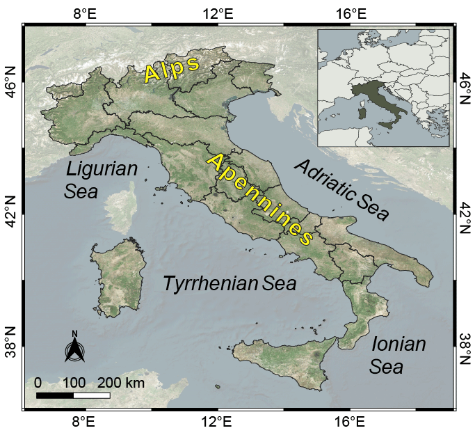
Figure 1Study area: the entire Italian territory. Background from © Microsoft; EPSG: 4326.
Italy is almost entirely seismically active, as it lies at the boundary between the Eurasian and African plates. Sedimentary, metamorphic, and igneous rocks of Paleozoic to Recent age are present, covered by different soil types with thicknesses from < 1 m to several metres. Given the conformation and moderate variation in latitude of the territory, the climate in Italy is quite variable. In the north it is generally colder, wetter, and locally alpine in the mountainous area. Along the peninsula, the climate is temperate, with the duration of dry summers increasing toward the south. The eastern Alpine and pre-Alpine areas as well as the northern Apennines have higher precipitation, with mean annual values exceeding 2000 mm. In contrast, areas with lower precipitation, between 400 and 600 mm yr−1, are mainly found in southern Sicily, Apulia, and southern Sardinia. Almost everywhere in Italy, November and July are the wettest and driest months, respectively (Fioravanti et al., 2022). The abundance of relief and climatic characteristics makes landslides a frequent and widespread phenomenon in Italy, where they are triggered primarily by rainfall and secondarily by rapid snowmelt and earthquakes (Guzzetti, 2000; Guzzetti and Tonelli, 2004).
To introduce the data used for the catalogue, it is important to state that the collected landslides are mostly those that had a direct or indirect impact on the population (structures and facilities, such as buildings, roads, or railways). Landslides that occurred in uninhabited areas or for which there are no institutional or news reports are rarely included in ITALICA.
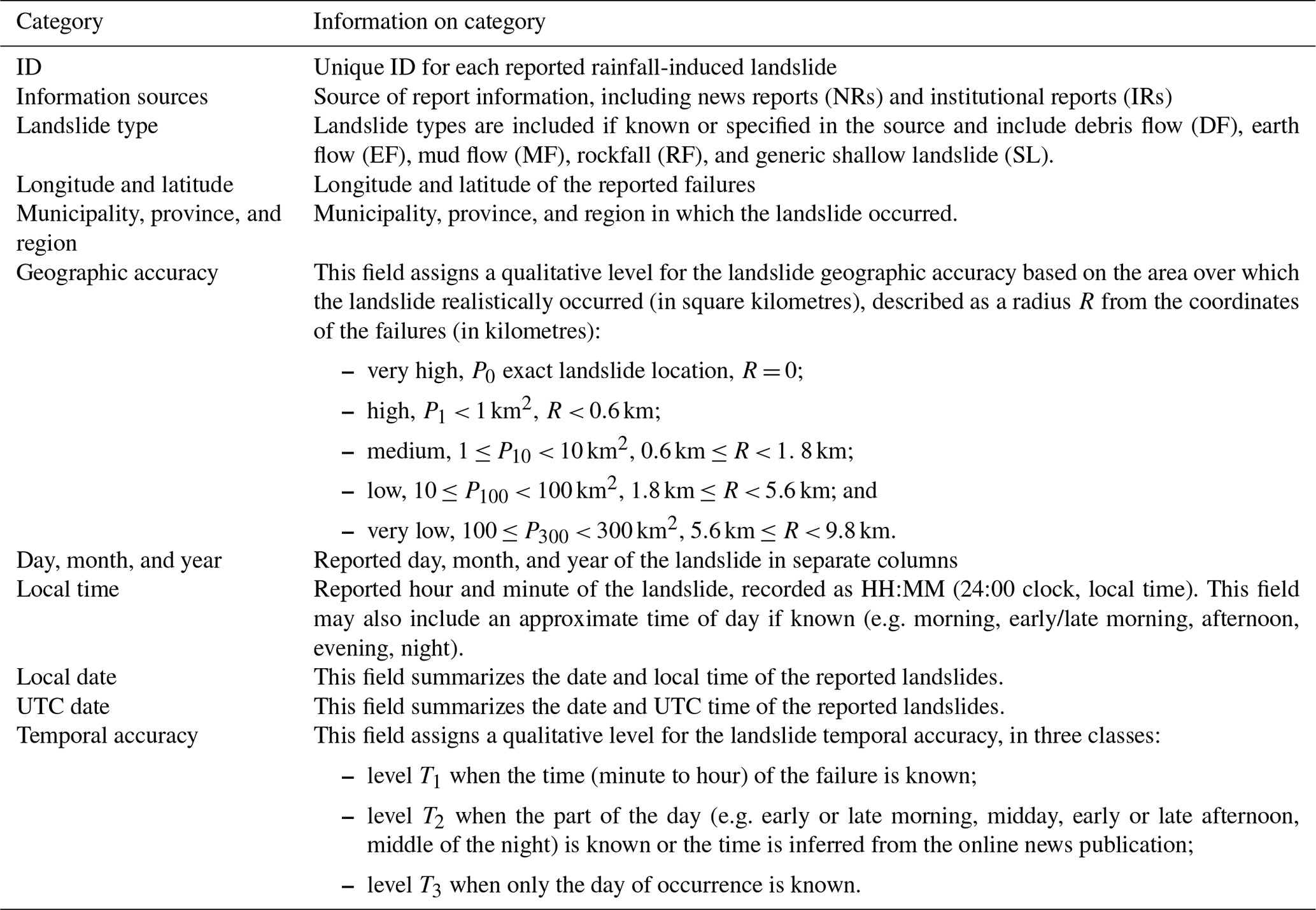
Data on landslides are, in general, difficult to retrieve and not fully reliable in terms of completeness and temporal and spatial accuracy. In order to obtain detailed and up-to-date information on the locations and timing of landslides in Italy, it has been necessary to concentrate efforts and human resources on various sources of information. Information was collected through the systematic reading of local newspapers (both printed and electronic), blogs, and online information sources, consultation of texts and periodicals held in municipal libraries and newspaper libraries, event reports, and reports following surveys, research in archives at different levels of government (municipal, provincial, and national), examination of online archival sources available from research organizations (e.g. SICI: an Italian acronym for Information System on Hydrological and Geomorphological Catastrophes; Guzzetti and Tonelli, 2004), and consultation and involvement of institutions in charge of land management, protection, and surveillance (e.g. regional functional centres, provincial commands of the national fire and rescue service and state forestry corps).
The analysis of sources of rainfall-induced landslides is challenging because the information is generally incomplete, inconsistent, and sometimes contradictory. For example, one source allows the accurate location of a landslide to be pinpointed by showing one or more photos of the surrounding landscape or of the kilometre marker in the case of a slope failure along a road. Another source may instead report details on the time or part of the day when the landslide occurred (late morning, evening); still others may indicate the type of landslide movement. Hopefully, with the help of the different sources, the reconstruction of where and when the landslide occurred can be established. In the event of a discrepancy, the search for additional sources continues until an agreed reconstruction is found. In the absence of minimum information such as the general location and the day of occurrence of the landslide, the event is discarded. Landslides were excluded from the catalogue if (1) the triggering factors were unknown or other than rainfall, (2) there was evidence of other causes operating along with rainfall in the activation (e.g. freeze–thaw cycles, rain on snow or snowmelt, seismic vibrations, anthropogenic influence), or (3) the landslide location in both space or time had poor accuracy, thus preventing the likely reconstruction of the triggering rainfall conditions (Palladino et al., 2018).
The catalogue contains the following information for each record: (i) source of information, (ii) landslide type (if available from the source of information), (iii) landslide location (coordinates, municipality, province, region, geographic accuracy), and (iv) temporal information (day, month, year, time, full date, temporal accuracy). Table 1 summarizes the main fields included in ITALICA. The rainfall that likely triggered the landslides contained in the catalogue will be analysed in a forthcoming publication.
Table 2Key terms used to select information on rainfall-induced landslides in the Google Alerts search tool. The double and triple check marks indicate the number of possible cross-combinations. Terms are translated from the Italian language.
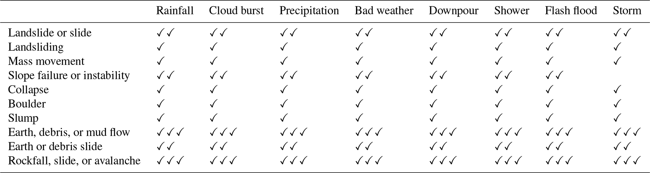
The information sources were classified into two categories: news reporting and institutional reporting. News reporting includes information from online and printed newspapers, news websites, social media, and blogs. Information from newspapers was initially gathered through systematic searches of regional and local online archives. For this purpose, we used Google Alerts, which allows alerts to be received whenever a pre-defined keyword or combinations thereof are mentioned somewhere on the web. We used various terms linked to bad weather conditions with all possible synonyms of landslides (Table 2). The Google Alerts search returns results when a rainfall-related term (e.g. “rainfall”, “downpour”) and a landslide-related term (e.g. “mass movement”, “collapse”) are found simultaneously on a web page. Specifically, Table 2 shows all possible 136 combinations searched for on the Internet. The same search was done by including the plural of terms, if any.
News about landslides was also retrieved from social media posts, often accompanied by photographs taken shortly after the failure. Examples of such information are blogs or Facebook and Twitter posts from users who experienced traffic jams due to landslides blocking roads. This kind of information makes it possible to better locate landslides in both space and time.
Institutional reporting comes from interventions following weather-related landslides carried out by institutional authorities, including the provincial Commands of the National Fire and Rescue Service, the regional civil protection functional centres, and the State Forestry Corps. News about road disruptions caused by geohydrological phenomena was provided by ANAS (Azienda Nazionale Autonoma delle Strade), an Italian company that manages the national road and motorway network, and CCISS (Centro Coordinamento Informazioni Sicurezza Stradale), an Italian agency that provides traffic and travel information. Information about landslides occurring along the Italian railway network is provided by RFI (Rete Ferroviaria Italiana). Institutional authorities have proven to be particularly useful, as they provide reliable and accurate information on the landslide location in space and time, usually being the first responders at the scene of the event. Institutional reporting was often cross-referenced with news derived from chronicle sources, and this made it possible, in most cases, to improve the temporal and spatial accuracy of the slope failures.
Where available, information on the landslide type was also collected. This was a critical task, because some of the sources (e.g. newspapers, firefighter reports, blogs) often used non-technical and therefore imprecise language to describe a slope failure. According to the categories defined by Cruden and Varnes (1996), we classified the landslides as DF, EF, MF, RF, and generic SL; the latter class was assigned in the cases where the description of the type of landslide was missing in the information sources.
The catalogue provides the geographic coordinates (longitude and latitude in WGS84) of individual failures along with administrative information, including municipality, province, and region. Landslides are then represented as points on a map (not polygons) with an associated geographic accuracy depending on the type and quality of the information. Using the details provided in the information sources, the landslides were mainly located using Google Earth to retrieve their coordinates, taking advantage of its multi-temporal set of images. The services of the Italian National Geoportal (http://www.pcn.minambiente.it/viewer/), which make it possible to consult all the maps (1 : 25 000 scale) provided by the Italian Army Geographical Support Office, were also used to search for some ambiguous or unknown toponyms.
From Peruccacci et al. (2017), we identified five categories of decreasing geographic accuracy P: P0 (very high); P1 < 1 km2 (high); 1 ≤ P10 < 10 km2 (medium); 10 ≤ P100 < 100 km2 (low); 100 ≤ P300 < 300 km2 (very low). The geographic accuracy is assigned based on the maximum circular area within which the landslide realistically occurred. A level P0, corresponding to the exact location of the landslide, was assigned to those failures for which the information source directly reported the geographic coordinates, the road with the exact kilometric indication, or even, in the case of a landslide occurring in a built-up area, the street and the approximate house number. In particular, the road kilometre was obtained by searching for kilometre markers in Google Street View; in a few cases, the landslide body was clearly visible. Level P 1 corresponds to a landslide located within a radius of less than about 0.6 km. For example, the name of the street was known but not the exact location. A medium level of geographic accuracy P10 was assigned when the information obtained from the source allowed the identification of a large road sector or a city block was affected by the landslide (within a radius of less than about 1.8 km). A low level of geographic accuracy P100 was attributed when the information source mentioned the district, borough, or hamlet of a municipality where the landslide occurred. Finally, a very low level of geographic accuracy P300 was given in the few cases where only the municipality is mentioned.
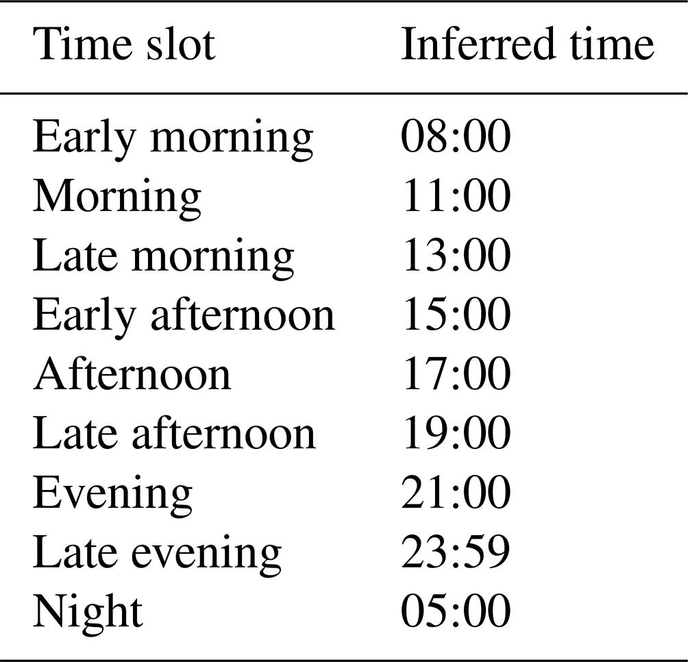
The date of occurrence (year, month, and day) is given for each failure. As for the geographic accuracy, we defined a temporal accuracy T in three classes: T1 when the time (from minutes to 1 h) of the event is known, T2 when the part of the day is known or the occurrence time can be inferred, and T3 when only the day of occurrence is known. The time of the T1 class can be derived from both news reporting and institutional reporting, assuming that the authorities involved (e.g. Fire and Rescue Service, RFI) are warned immediately after the landslide event. The T2 class is assigned in two cases. When the news specifies that the landslide occurred in a time slot (e.g. late morning, early afternoon), an inferred time is given according to Table 3, which provides four main sub-divisions of the day into nine time slots. In the case of online news reporting, the time at which the news was first published is used to determine the inferred time of the failure, assuming that the landslide certainly occurred before the news was posted. Lastly, if the news only reports the day on which the event occurred, the landslide is assigned a daily temporal accuracy of T3 and is conventionally assumed to have occurred at the end of the day (23:59 local time).
Table 3Inferred time of the landslide based on the time slot derived from the sources.
Information was collected and entered into the catalogue by several operators, who were assigned one or more administrative regions within which to conduct the search. The size of the team varied over time, with a minimum of five and a maximum of nine operators working simultaneously. In order to limit subjectivity in the compilation of the catalogue, several workshop and training courses were organized to ensure the adoption of uniform criteria by all the operators. A validation of the landslides added in the catalogue was carried out by assigning a random sample of the records from one operator to another one. In most cases the records were filled in with the same details. In case of discrepancies, they were double-checked by the team.
The catalogue records were stored in a spreadsheet and converted into comma-separated-value (.csv) and geoPackage (.gpkg) files to be analysed and visualized in a geographic information system (GIS) environment.
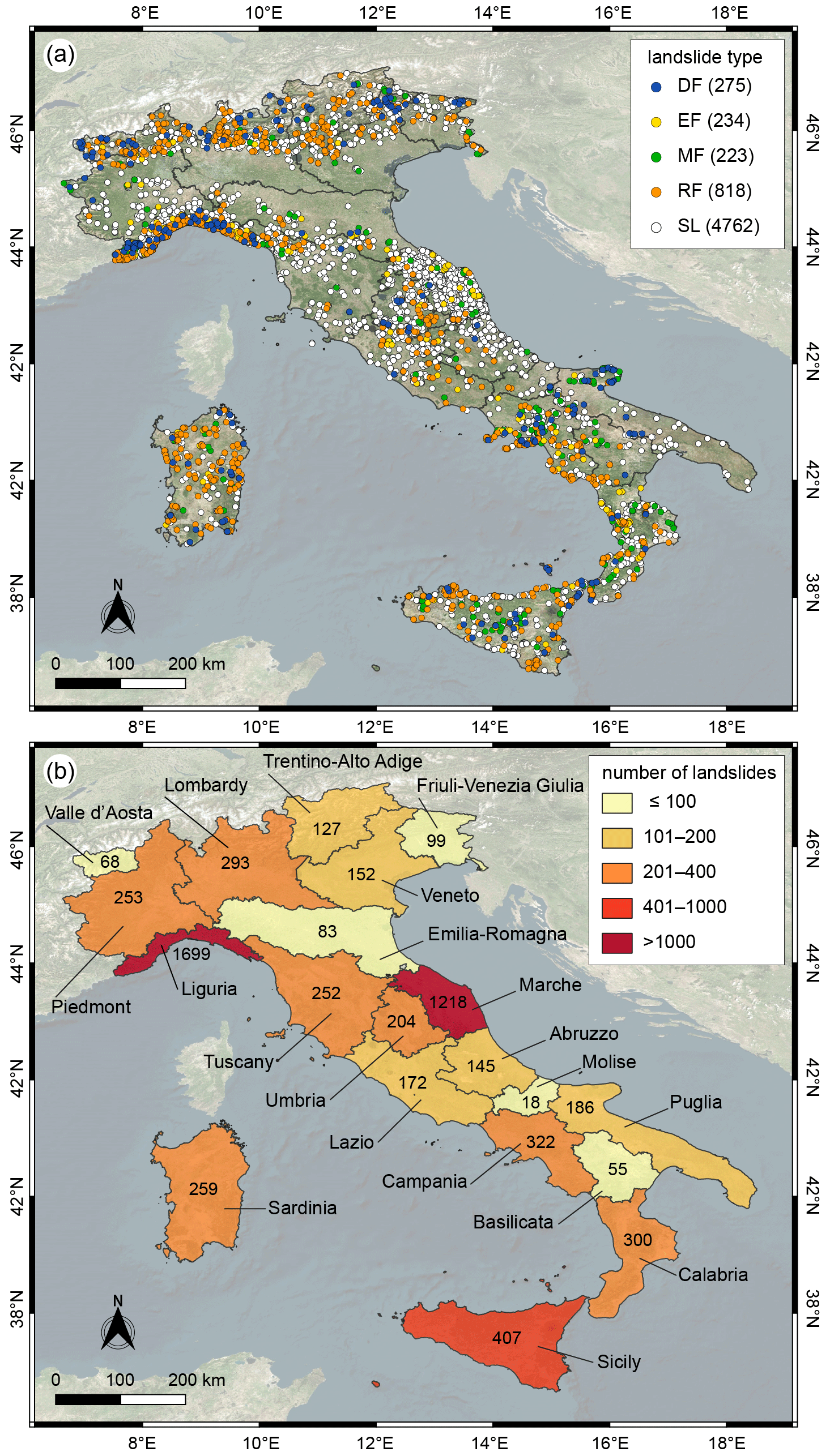
Figure 2(a) Locations of the catalogued landslides, classified according to type. Key: DF, debris flow; EF, earth flow; MF, mud flow; RF, rockfall; SL, unspecified shallow landslide. The number of landslides of each type is given in brackets in the legend. (b) Number of landslides for each of the 20 Italian administrative regions (names in Italian). Colours of the regions are associated with the number of landslides in five classes. Background from © Microsoft; EPSG: 4326.
ITALICA lists 6312 records with information on rainfall-induced landslides that occurred in the Italian territory between January 1996 and December 2021. Figure 2a shows the distribution of the 6312 slope failures classified by type (according to Cruden and Varnes, 1996). The landslides are fairly evenly distributed in the mountainous and hilly areas of the country. Some areas have a higher concentration of events due to specific agreements with local authorities aimed at improving landslide forecasting. Overall, about three-quarters (4762) of the catalogued mass movements were classified as generic SL, while 13 % (818) of the phenomena are RF and are homogeneously distributed over the whole territory. DF, EF, and MF, respectively, together cover less than 12 % (732) of the catalogue. DF is mainly located in the northern part of the country, particularly in the Alps mountain chain. Figure 2b shows the number of landslides collected in each of the 20 administrative Italian regions. Overall, half of the regions count more than 200 landslides. In two regions, namely Liguria and Marche, more than 1000 landslides were recorded, thanks to specific agreements with the regional civil protection offices.
Figure 3 shows the monthly distribution of the landslides, grouped by season. November, May, December, March, and January are in descending order, characterized by high variability in the number of landslides.
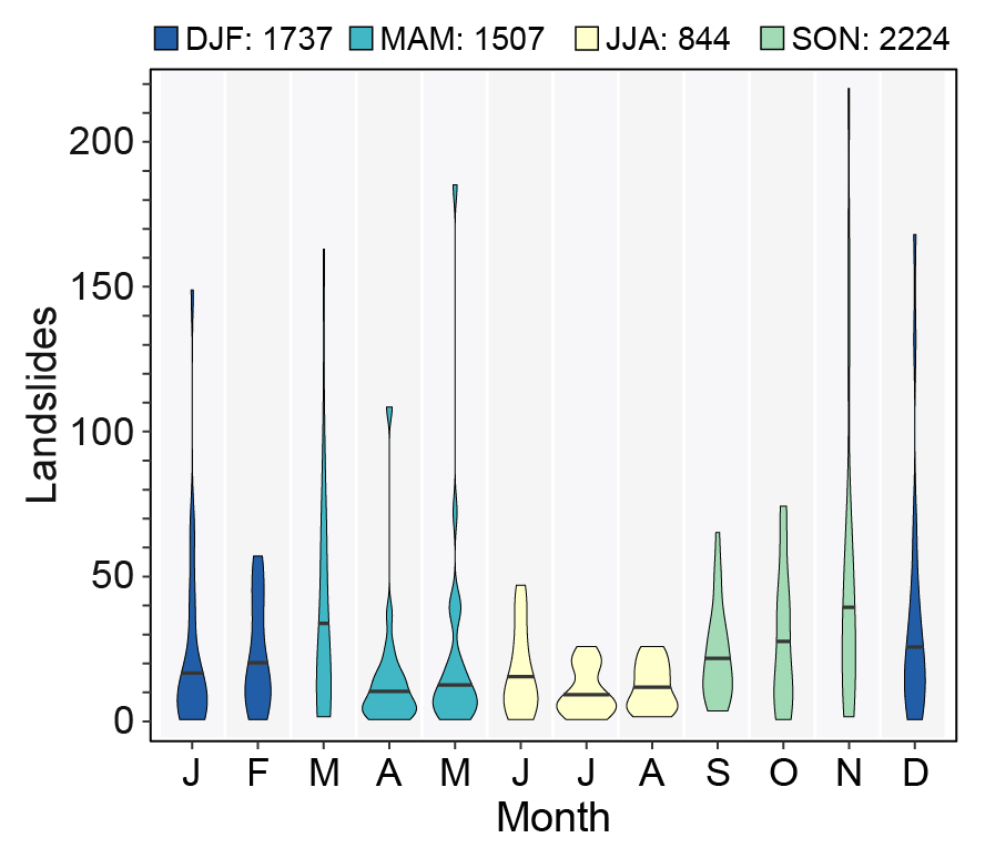
Figure 3Violin plot of the monthly distribution of landslides in ITALICA. Months are grouped into four seasons: winter, DJF (December–January–February); spring, MAM (March–April–May); summer, JJA (June–July–August); autumn, SON (September–October–November). The number of landslides in each season is shown in the legend.
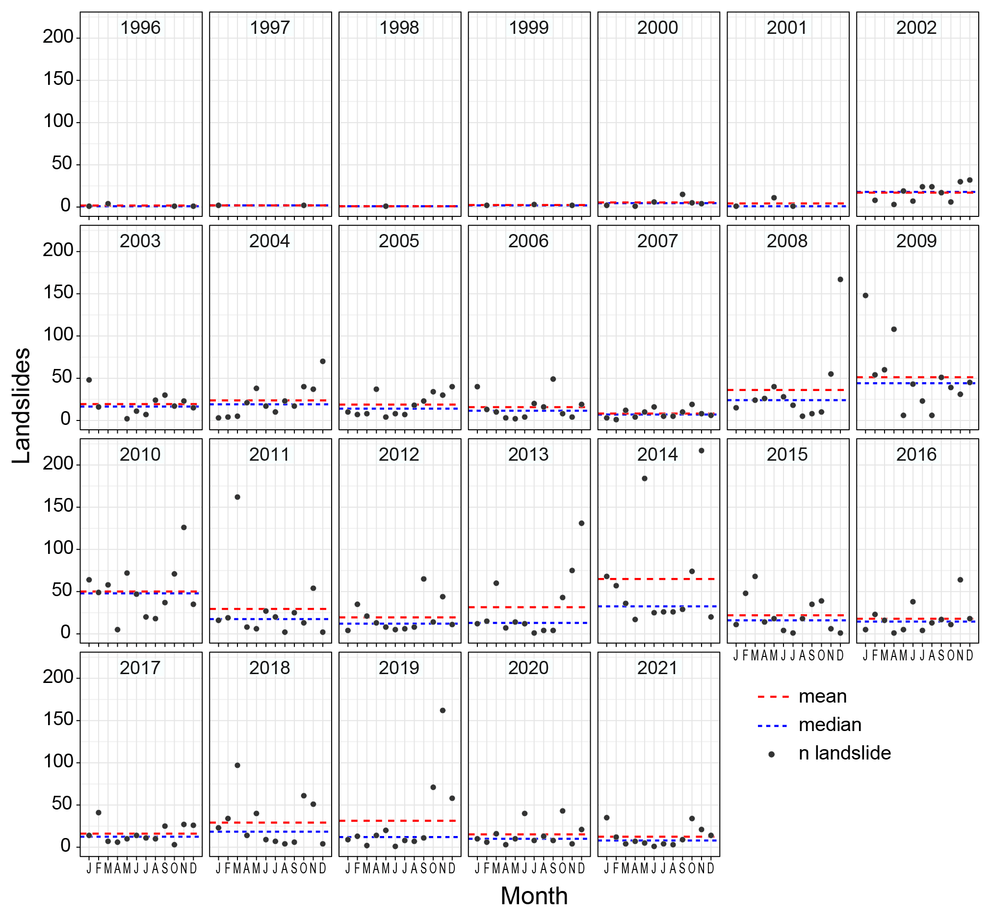
Figure 4Monthly distribution of landslides in the observation period January 1996–December 2021. The mean and median number of landslides for each year are also shown.
Figure 4 plots the number of landslides in each month in the entire observation period January 1996–December 2021. For each year, the mean and median values of the monthly number of landslides are shown in the corresponding panel. The first 6 years show much lower monthly and annual values than the following 20 years: only 65 landslides were collected between 1996 and 2001. The limited number of landslides does not depend on particular weather conditions during the period but on the fact that historical data were available for only a few regions. Overall, large variations are observed between monthly and annual values. In particular, four years, namely 2008, 2009, 2010, and 2014, have significantly higher mean and median values than the other years. Except for the years 2013, 2014, and 2019, all the others show similar mean and median values. Table 4 lists the mean, median, and total number of landslides per month in the period 2002–2021, which is the most representative period (Fig. 4). November is the month with the highest statistics on the number of failures. The monthly median varies by a factor of greater than 4, thus evidencing the seasonality of the process. The difference between the mean and median values is significant for the months from November to May, indicating that the monthly distributions are not normal, as depicted by the violin plots in Fig. 3. Other months are characterized by a lower variability. Overall, 35.1 % of the catalogued landslides occurred in autumn (September–October–November: SON), 27.7 % in winter (December–January–February: DJF), 23.9 % in spring (March–April–May: MAM), and only 13.3 % in summer (June–July–August: JJA). Landslides that occurred in JJA are mainly located in the Alps, while those that occurred in DJF are mainly found in the Apennine chain.
Table 4Monthly statistics of the number of landslides in the period 2002–2021.
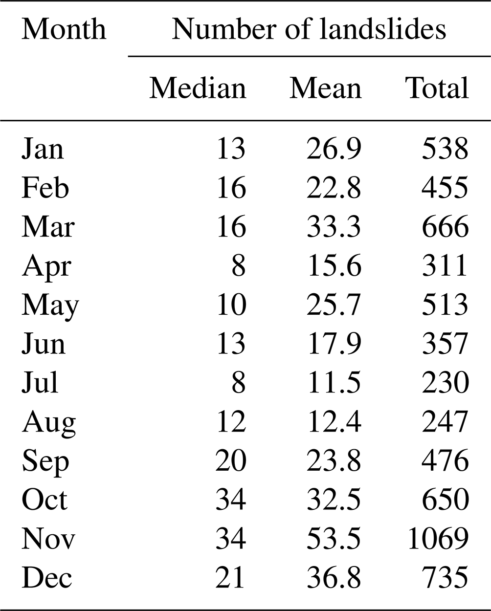
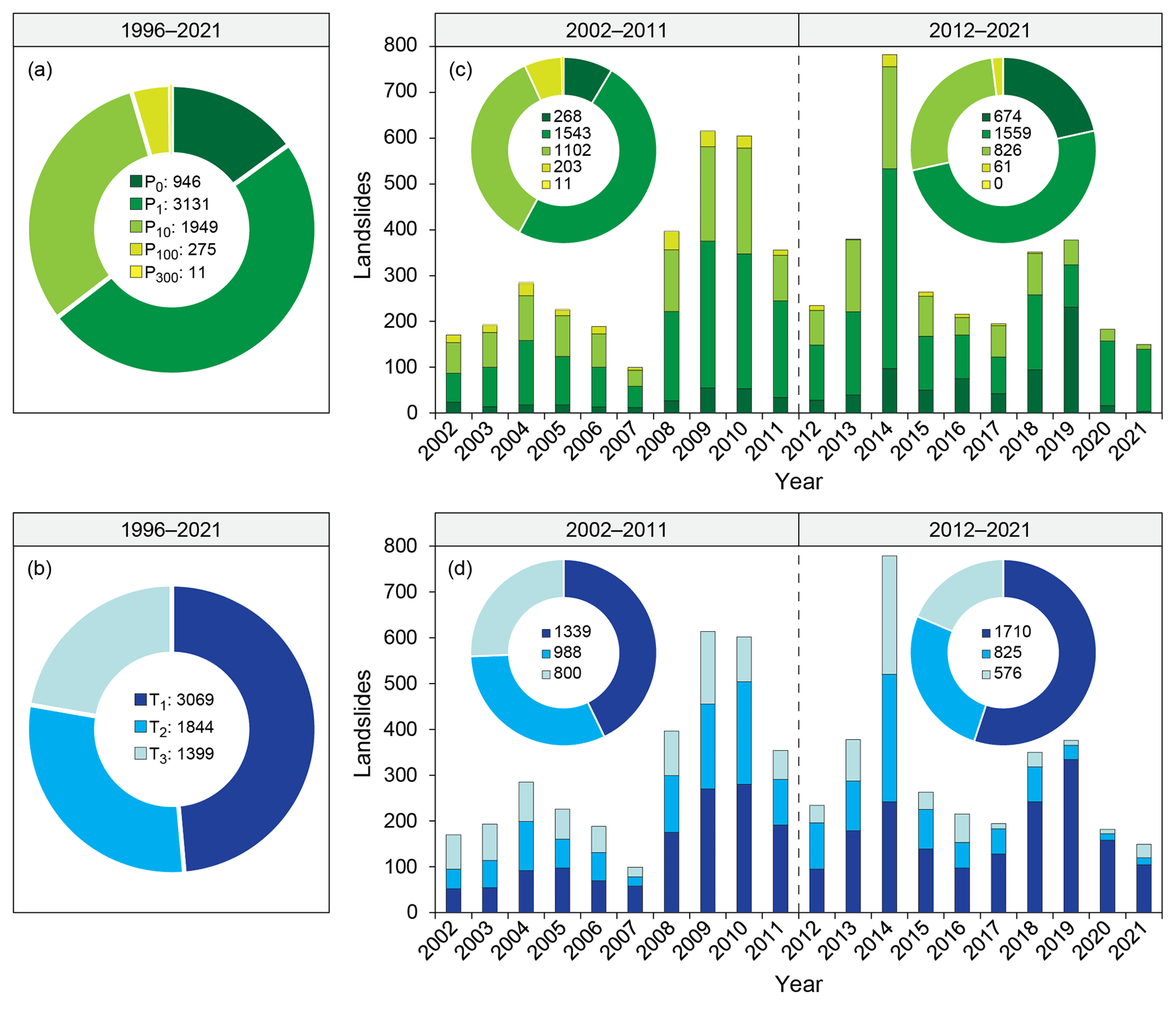
Figure 5(a, b) Doughnut charts of the number of landslides with different levels of geographic (P0, P1, P10, P100, P300) and temporal accuracy (T1, T2, T3) in the overall observation period 1996–2021. (c, d) Bar charts of the annual number of landslides for the different geographic and temporal accuracy levels over the period 2002–2021. The doughnut charts in the insets show the comparison of the number of landslides in each class in the two sub-periods 2002–2011 and 2012–2021. Refer to Table 1 for a description of the geographic and temporal accuracy levels.
Figure 5 shows the number of landslides with different levels of geographic and temporal accuracy (see Table 1 for descriptions) over the entire observation period 1996–2021 and two 10-year sub-periods 2002–2011 and 2012–2021, which have a comparable number of landslides, 3127 and 3120, respectively. The number of landslides collected each year is also depicted. About half of the landslide records (3131) have a high geographic accuracy (Fig. 5a), and more than 95 % (6026) of the landslides were located with an uncertainty of less than 10 km2. Only 285 (4.5 %) landslides have a low and very low geographic accuracy. In contrast, for almost half of the catalogued landslides (3069), the exact time of occurrence is known (Fig. 5b). For another quarter of the catalogue, the part of the day is known. Only 22 % of the landslides (1399) are characterized by a lower temporal accuracy.
Figure 5c and d show that geographic and temporal accuracy has improved in the most recent sub-period. The number of landslides with very high geographic accuracy more than doubled from 2002–2011 to 2012–2021 (Fig. 5c). Specifically, in the recent 2012–2021 sub-period, the locations of about three-quarters of the listed failures are known with an accuracy of less than 1 km2 and the time of occurrence with an uncertainty of less than 2–3 h. In addition, the number of landslides for which only the day of occurrence is known (T3) decreased from 26 % to 19 % of the total records (Fig. 5d).
Overall, more than one-third of the entire catalogue (2176) is highly accurate in both space (P0 and P1) and time (T1), whereas less than 2 % of the catalogue (114) has concurrently low and very low (P100 and P300) geographic accuracy and only daily (T3) temporal resolution. These last records were collected mainly in the first years of the catalogue's compilation.
Figure 6 shows the sub-division of the records according to the source of information: institutional reports (IRs) or news reports (NRs). Overall, 58 % of the landslides were catalogued thanks to the information gathered from news reports. The same figure also shows how the information source affects the geographic and temporal accuracy of the landslide records. Among all 946 landslides with very high geographic accuracy, 766 (81 %) were catalogued from information in institutional reports. About 75 % (2289 out of 3069) of all landslides with very high temporal accuracy (T1) came from institutional reports. Geographic and temporal accuracy substantially decreases when the landslide information is collected from news reports.
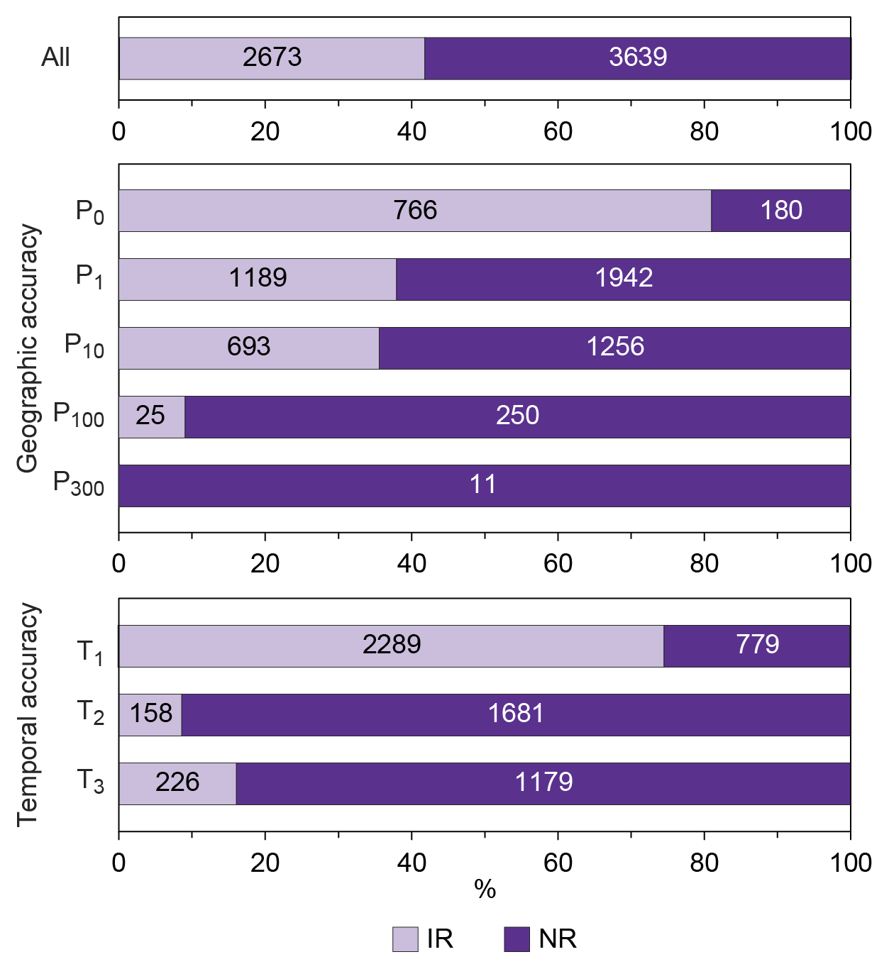
Figure 6Bar chart of the number of landslides (1996–2021) for which information was obtained from institutional reports (IRs) or news reports (NRs), divided into classes of geographic and temporal accuracy.
ITALICA is available at https://doi.org/10.5281/zenodo.8009366 (Brunetti et al., 2023).
ITALICA is the largest catalogue of rainfall-induced landslides with accurate spatial and temporal localization currently available in Italy. The selection criteria are relatively strict compared to other inventories. In particular, at the lowest acceptable geographic accuracy level P300, the location of the landslide can still be indicated within a radius of less than 10 km. Similarly, the worst level of temporal accuracy T3 still requires one to know at least the day of occurrence of the landslide, which is the usual maximum accuracy in most catalogues. These two constraints, combined with the requirement for specific reference to rainfall as the sole triggering factor of the landslides, significantly limit the number of events suitable for the catalogue. As a result, an average of 40 % of the analysed news-reporting items is discarded. These strict and stringent criteria limit the use of many technical reports produced in the aftermath of severe weather events in which generally only the date of inspection and not the date of occurrence of the landslide is reported. In this regard, particularly useful are the reports provided by firefighters, which are accurate in both space and time. Unfortunately, the availability of such data is not uniform across the country due to the different data-sharing policies of provincial and regional authorities. We noticed how both geographic and temporal accuracies increase substantially when information on landslides is collected from institutional reports (Fig. 6). We can therefore state that a higher availability of such data sources would result in a more thorough catalogue.
Gathering information on rainfall-induced landslides that is accurate in both space and time requires a large amount of human resources and time. For example, in order to get an accurate spatial location of landslides along roads, we explored the area using Google Street View until we found the proper sites, recognizable either through the images accompanying the information source or from the mileage information. The collection of such information can only partially be automated, as expert supervision remains necessary.
The high spatial and temporal accuracy of ITALICA is its main strength. The demand for accuracy in landslide catalogues is critical for effective and operational landslide prediction through rainfall thresholds (Segoni et al., 2018; Guzzetti et al., 2020, 2022). Without this high level of accuracy, the rainfall responsible for triggering landslides cannot be reliably reconstructed. For this application, we suggest excluding records with low (P100) and very low (P300) geographic accuracy. Subsets of the catalogue have already been used to calculate national and regional rainfall thresholds implemented in early-warning systems in Italy (Guzzetti et al., 2020). ITALICA can also be exploited to calibrate and/or validate various models for temporal prediction of rainfall-induced landslides.
Another strength of the catalogue is that the collection was made according to strict objective and homogeneous criteria throughout the country, which limits the inherent subjectivity in compiling catalogues from different sources and by multiple operators.
As with other landslide catalogues available in the literature (e.g. Kirschbaum et al., 2010, and references therein), this catalogue also exhibits some spatial inhomogeneity (Fig. 2), which may have implications for users. The main reason for this is the regional scale at which the search for information was conducted as a result of collaboration agreements with some Italian administrative regions (i.e. Liguria, Marche, and Sardinia). For instance, the catalogue lists information on 1703 (27 % of all entries) and 1220 (19 %) rainfall-induced landslides in the Liguria and Marche regions, respectively. Excluding years recognized as extremely dry, a possible functional definition of completeness requires that a historical landslide catalogue includes a substantial number of landslides in any year. According to this definition, ITALICA is substantially complete for the Liguria, Marche, and Sardinia regions, for which there has been continuity in data collection from 2012 onwards. Despite the inhomogeneity of the data, ITALICA provides sufficient numbers of rainfall-induced landslides at the scale of administrative regions (Fig. 3b), which can be used for landslide-prediction models. As an example, as stated in Peruccacci et al. (2017), reliable rainfall thresholds for the possible landslide initiation can be defined in areas where the number of available records is larger than or equal to 100. The catalogue is continuously being updated by us, and future collaboration with other Italian regions will hopefully increase the spatial homogeneity of the data.
Compared to other catalogues of landslides in Italy, ITALICA stands out for the following reasons. (i) It contains exclusively landslides induced by rainfall, unlike datasets presented in Guzzetti et al. (1994), Innocenzi et al. (2017), and Calvello and Pecoraro (2018), which contain information on landslides triggered by all causes. (ii) It covers a longer period (26 years, 1996–2021) than that covered by Innocenzi et al. (2017) (4 years, 2012–2015) and Calvello and Pecoraro (2018) (8 years, 2010–2017). (iii) It is based on both technical and chronicle sources of information. (iv) It is highly accurate in both space and time.
ITALICA cannot be compared with the IFFI inventory, as the two products are structurally different. The IFFI inventory includes landslides induced by multiple causes (e.g. anthropogenic, seismic) and mostly lacks information on the temporal occurrence of the mapped failures. A comparison with the Polaris (Bianchi and Salvati, 2023) and ISPRA (Trigila et al., 2021) catalogues is not advisable, since the two contain information on landslides induced by all types of triggers that caused deaths, injuries, evacuations, and damage. As a matter of fact, in the 4-year period 2017–2020, ITALICA lists 1102 landslides, while the Polaris and ISPRA catalogues contain 94 landslides with deaths and injuries and 645 landslides with deaths, injuries, evacuations, and damage, respectively.
Global and continental catalogues available in the literature report a small number of landslides in the Italian territory, i.e. 45 landslides in the period 2008–2013 according to Kirschbaum et al. (2015), 72 landslides in the period 2005–2014 according to Haque et al. (2016), and 39 landslides in the period 2004–2016 according to Froude and Petley (2018). As expected, a national catalogue is certainly more comprehensive than the global catalogues in the area of interest addressed.
Recently, projects were launched that involve citizens in providing reports on natural disasters that take lives and destroy roads, buildings, and other property, such as Landslide Reporter, a NASA citizen science project that asks citizen scientists from around the world to report landslides in their area, providing continuous feedback from the real world (https://gpm.nasa.gov/landslides/index.html, last access: 6 July 2023). In the near future, we plan to use similar initiatives. Additionally, the usefulness of social media data is being tested and seems promising, suggesting their possible future integration into a multi-information-source catalogue (Franceschini et al., 2022a, b).
In general, ITALICA's information on rainfall-induced landslides in Italy, with special emphasis on their spatial and temporal locations, can be crucial for decision-making in landslide risk management. The methodology used to populate ITALICA has already been applied in a standardized way by various operators in different geographic and climatic contexts in Italy and can easily be used to compile new catalogues of high spatial and temporal accuracy in other countries. ITALICA can certainly serve as an example for the collection of new accurate data for setting rainfall thresholds.
SP, MTB: conceptualization, data curation, formal analysis, investigation, supervision, visualization, writing – original draft preparation, review, and editing. SLG, MM: conceptualization, data curation, formal analysis, investigation, visualization, writing – original draft preparation, review, and editing. MS: data curation, investigation. FG: funding acquisition, writing – review and editing.
The contact author has declared that none of the authors has any competing interests.
Publisher's note: Copernicus Publications remains neutral with regard to jurisdictional claims in published maps and institutional affiliations.
Devis Bartolini, Francesca Brutti, Cinzia Bianchi, Costanza Calzolari, Barbara Denti, Eleonora Gioia, Silvia Luciani, Maria Elena Martinotti, Michela Rosa Palladino, Luca Pisano, Anna Roccati, Monica Solimano, Carmela Vennari, Giovanna Vessia, and Alessia Viero contributed to collecting landslide information. We thank the functional centre for civil protection of the Marche region and provincial authorities of the national fire and rescue service, Centro Coordinamento Informazioni Sicurezza Stradale, and Rete Ferroviaria Italiana for providing landslide information. We thank the editor and the three anonymous reviewers for their helpful comments and suggestions that significantly improved the manuscript.
This research has been financially supported by the Italian National Department for Civil Protection (DPC) (Intese Operative DPC nos. 619, 672, 1015, and 1181; Accordi di Collaborazione 2014, 2015, 2016), the environmental department of the Liguria region (Convenzione 2013), the Apulia region (Accordo di Collaborazione 2016), the regional agency for the protection of the environment of the Liguria region (Accordi di Collaborazione 2017, 2018, 2021), and the civil protection department of the Sardinia region (Accordi di Collaborazione 2016, 2021).
This paper was edited by James Thornton and reviewed by three anonymous referees.
Andres, N. and Badoux, A.: The Swiss flood and landslide damage database: Normalisation and trends, J. Flood Risk Manag., 12, e12510, https://doi.org/10.1111/jfr3.12510, 2019.
Belair, G. M., Jones, E. S., Slaughter, S. L., and Mirus, B. B.: Landslide Inventories across the United States version 2, Geological Survey data release, https://doi.org/10.5066/P9FZUX6N, 2022.
Berti, M., Martina, M. L. V., Franceschini, S., Pignone, S., Simoni, A., and Pizziolo, M.: Probabilistic rainfall thresholds for landslide occurrence using a Bayesian approach, J. Geophys. Res.-Earth, 117, F04006, https://doi.org/10.1029/2012JF002367, 2012.
Bianchi, C. and Salvati, P.: Rapporto Periodico sul Rischio posto alla Popolazione italiana da Frane e Inondazioni. Anno 2022, Istituto di Ricerca per la Protezione Idrogeologica (IRPI), Consiglio Nazionale delle Ricerche (CNR), https://doi.org/10.30437/REPORT2021, 2023 (in Italian).
Bíl, M., Raška, P., Dolák, L., and Kubeček, J.: CHILDA – Czech Historical Landslide Database, Nat. Hazards Earth Syst. Sci., 21, 2581–2596, https://doi.org/10.5194/nhess-21-2581-2021, 2021.
Brunetti, M. T., Melillo, M., Gariano, S. L., Guzzetti, F., Bartolini, D., Brutti, F., Bianchi, C., Calzolari, C., Denti, B., Gioia, E., Luciani, S., Martinotti, M. E., Palladino, M. R., Pisano, L., Roccati, A., Solimano, M., Vennari, C., Vessia, G., Viero, A., and Peruccacci, S.: ITALICA (ITAlian rainfall-induced LandslIdes CAtalogue), Zenodo [data set], https://doi.org/10.5281/zenodo.8009366, 2023.
Calvello, M. and Pecoraro, G.: FraneItalia: a catalog of recent Italian landslides, Geoenvironmental Disasters, 5, 13, https://doi.org/10.1186/s40677-018-0105-5, 2018.
Corominas, J., Einstein, H., Davis, T., Strom, A., Zuccaro, G., Nadim, F., and Verdel, T.: Glossary of Terms on Landslide Hazard and Risk, in: Engineering Geology for Society and Territory – Volume 2, edited by: Lollino, G., Giordan, D., Crosta, G. B., Corominas, J., Azzam, R., Wasowski, J., and Sciarra, N., Springer International Publishing, Cham, 1775–1779, https://doi.org/10.1007/978-3-319-09057-3_314, 2015.
Cruden, D. and Varnes, D.: Landslide Types and Processes, Chapter 3 in Landslides: Investigation and Mitigation. Special Report 247, National Research Council, Spec. Rep. Natl. Res. Counc. Transp. Res. Board, Washington, DC, 36–75, 1996.
Damm, B. and Klose, M.: Landslide Database for the Federal Republic of Germany: A Tool for Analysis of Mass Movement Processes, in: Landslide Science for a Safer Geoenvironment, edited by: Sassa, K., Canuti, P., and Yin, Y., Springer Cham, 787–792, https://doi.org/10.1007/978-3-319-05050-8_121, 2014.
Damm, B. and Klose, M.: The landslide database for Germany: Closing the gap at national level, Geomorphology, 249, 82–93, https://doi.org/10.1016/j.geomorph.2015.03.021, 2015.
Devoli, G., Strauch, W., Chávez, G., and Høeg, K.: A landslide database for Nicaragua: a tool for landslide-hazard management, Landslides, 4, 163–176, https://doi.org/10.1007/s10346-006-0074-8, 2007.
Fioravanti, G., Fraschetti, P., Lena, F., Perconti, W., Piervitali, E.: I normali climatici 1991–2020 di temperatura e precipitazione in Italia, Stato dell'Ambiente 99/2022, ISPRA, Rome, Italy, ISBN 978-88-448-1120-4, 2022 (in Italian).
Foster, C., Pennington, C. V. L., Culshaw, M. G., and Lawrie, K.: The national landslide database of Great Britain: development, evolution and applications, Environ. Earth Sci., 66, 941–953, https://doi.org/10.1007/s12665-011-1304-5, 2012.
Franceschini, R., Rosi, A., Catani, F., and Casagli, N.: Exploring a landslide inventory created by automated web data mining: the case of Italy, Landslides, 19, 841–853, https://doi.org/10.1007/s10346-021-01799-y, 2022a.
Franceschini, R., Rosi, A., del Soldato, M., Catani, F., and Casagli, N.: Integrating multiple information sources for landslide hazard assessment: the case of Italy, Sci. Rep., 12, 20724, https://doi.org/10.1038/s41598-022-23577-z, 2022b.
Froude, M. J. and Petley, D. N.: Global fatal landslide occurrence from 2004 to 2016, Nat. Hazards Earth Syst. Sci., 18, 2161–2181, https://doi.org/10.5194/nhess-18-2161-2018, 2018.
Guzzetti, F.: Landslide fatalities and the evaluation of landslide risk in Italy, Eng. Geol., 58, 89–107, https://doi.org/10.1016/S0013-7952(00)00047-8, 2000.
Guzzetti, F. and Tonelli, G.: Information system on hydrological and geomorphological catastrophes in Italy (SICI): a tool for managing landslide and flood hazards, Nat. Hazards Earth Syst. Sci., 4, 213–232, https://doi.org/10.5194/nhess-4-213-2004, 2004.
Guzzetti, F., Cardinali, M., and Reichenbach, P.: The AVI project: A bibliographical and archive inventory of landslides and floods in Italy, Environ. Manage., 18, 623–633, https://doi.org/10.1007/BF02400865, 1994.
Guzzetti, F., Peruccacci, S., Rossi, M., and Stark, C. P.: Rainfall thresholds for the initiation of landslides in central and southern Europe, Meteorol. Atmos. Phys., 98, 239–267, https://doi.org/10.1007/s00703-007-0262-7, 2007.
Guzzetti, F., Gariano, S. L., Peruccacci, S., Brunetti, M. T., Marchesini, I., Rossi, M., and Melillo, M.: Geographical landslide early warning systems, Earth-Sci. Rev., 200, 102973, https://doi.org/10.1016/j.earscirev.2019.102973, 2020.
Guzzetti, F., Gariano, S. L., Peruccacci, S., Brunetti, M. T., and Melillo, M.: Rainfall and landslide initiation, in: Rainfall, edited by: Morbidelli, R., Elsevier, 427–450, https://doi.org/10.1016/B978-0-12-822544-8.00012-3, 2022.
Haque, U., Blum, P., da Silva, P. F., Andersen, P., Pilz, J., Chalov, S. R., Malet, J.-P., Auflič, M. J., Andres, N., Poyiadji, E., Lamas, P. C., Zhang, W., Peshevski, I., Pétursson, H. G., Kurt, T., Dobrev, N., García-Davalillo, J. C., Halkia, M., Ferri, S., Gaprindashvili, G., Engström, J., and Keellings, D.: Fatal landslides in Europe, Landslides, 13, 1545–1554, https://doi.org/10.1007/s10346-016-0689-3, 2016.
Herrera, G., Mateos, R. M., García-Davalillo, J. C., Grandjean, G., Poyiadji, E., Maftei, R., Filipciuc, T.-C., Jemec Auflič, M., Jež, J., Podolszki, L., Trigila, A., Iadanza, C., Raetzo, H., Kociu, A., Przyłucka, M., Kułak, M., Sheehy, M., Pellicer, X. M., McKeown, C., Ryan, G., Kopačková, V., Frei, M., Kuhn, D., Hermanns, R. L., Koulermou, N., Smith, C. A., Engdahl, M., Buxó, P., Gonzalez, M., Dashwood, C., Reeves, H., Cigna, F., Liščák, P., Pauditš, P., Mikulėnas, V., Demir, V., Raha, M., Quental, L., Sandić, C., Fusi, B., and Jensen, O. A.: Landslide databases in the Geological Surveys of Europe, Landslides, 15, 359–379, https://doi.org/10.1007/s10346-017-0902-z, 2018.
Hess, J., Rickli, C., McArdell, B., and Stähli, M.: Investigating and Managing Shallow Landslides in Switzerland, in: Landslide Science for a Safer Geoenvironment, edited by: Sassa, K., Canuti, P., and Yin, Y., Springer Cham, 805–808, https://doi.org/10.1007/978-3-319-05050-8_124, 2014.
Innocenzi, E., Greggio, L., Frattini, P., and de Amicis, M.: A Web-Based Inventory of Landslides Occurred in Italy in the Period 2012–2015, in: Advancing Culture of Living with Landslides, edited by: Mikos, M., Tiwari, B., Yin, Y., and Sassa, K., Springer International Publishing, Cham, 1127–1133, https://doi.org/10.1007/978-3-319-53498-5_128, 2017.
Jaedicke, C., Lied, K., and Kronholm, K.: Integrated database for rapid mass movements in Norway, Nat. Hazards Earth Syst. Sci., 9, 469–479, https://doi.org/10.5194/nhess-9-469-2009, 2009.
Kirschbaum, D., Stanley, T., and Zhou, Y.: Spatial and temporal analysis of a global landslide catalog, Geomorphology, 249, 4–15, https://doi.org/10.1016/j.geomorph.2015.03.016, 2015.
Kirschbaum, D. B., Adler, R., Hong, Y., Hill, S., and Lerner-Lam, A.: A global landslide catalog for hazard applications: method, results, and limitations, Nat. Hazards, 52, 561–575, https://doi.org/10.1007/s11069-009-9401-4, 2010.
Komac, M. and Hribernik, K.: Slovenian national landslide database as a basis for statistical assessment of landslide phenomena in Slovenia, Geomorphology, 249, 94–102, https://doi.org/10.1016/j.geomorph.2015.02.005, 2015.
Luetzenburg, G., Svennevig, K., Bjørk, A. A., Keiding, M., and Kroon, A.: A national landslide inventory for Denmark, Earth Syst. Sci. Data, 14, 3157–3165, https://doi.org/10.5194/essd-14-3157-2022, 2022.
Melillo, M., Brunetti, M. T., Peruccacci, S., Gariano, S. L., Roccati, A., and Guzzetti, F.: A tool for the automatic calculation of rainfall thresholds for landslide occurrence, Environ. Model. Softw., 105, 230–243, https://doi.org/10.1016/j.envsoft.2018.03.024, 2018.
Mrozek, T., Kułak, M., Grabowski, D., and Wójcik, A.: Landslide Counteracting System (SOPO): Inventory Database of Landslides in Poland, in: Landslide Science for a Safer Geoenvironment, edited by: Sassa, K., Canuti, P., and Yin, Y., Springer Cham, 815–820, https://doi.org/10.1007/978-3-319-05050-8_126, 2014.
Palladino, M. R., Viero, A., Turconi, L., Brunetti, M. T., Peruccacci, S., Melillo, M., Luino, F., Deganutti, A. M., and Guzzetti, F.: Rainfall thresholds for the activation of shallow landslides in the Italian Alps: the role of environmental conditioning factors, Geomorphology, 303, 53–67, https://doi.org/10.1016/j.geomorph.2017.11.009, 2018.
Pennington, C., Freeborough, K., Dashwood, C., Dijkstra, T., and Lawrie, K.: The National Landslide Database of Great Britain: Acquisition, communication and the role of social media, Geomorphology, 249, 44–51, https://doi.org/10.1016/j.geomorph.2015.03.013, 2015.
Peruccacci, S., Brunetti, M. T., Gariano, S. L., Melillo, M., Rossi, M., and Guzzetti, F.: Rainfall thresholds for possible landslide occurrence in Italy, Geomorphology, 290, 39–57, https://doi.org/10.1016/j.geomorph.2017.03.031, 2017.
Rosser, B., Dellow, S., Haubrock, S., and Glassey, P.: New Zealand's National Landslide Database, Landslides, 14, 1949–1959, https://doi.org/10.1007/s10346-017-0843-6, 2017.
Salvati, P., Bianchi, C., Rossi, M., and Guzzetti, F.: Societal landslide and flood risk in Italy, Nat. Hazards Earth Syst. Sci., 10, 465–483, https://doi.org/10.5194/nhess-10-465-2010, 2010.
Salvati, P., Petrucci, O., Rossi, M., Bianchi, C., Pasqua, A. A., and Guzzetti, F.: Gender, age and circumstances analysis of flood and landslide fatalities in Italy, Sci. Total Environ., 610–611, 867–879, https://doi.org/10.1016/j.scitotenv.2017.08.064, 2018.
Segoni, S., Rossi, G., Rosi, A., and Catani, F.: Landslides triggered by rainfall: A semi-automated procedure to define consistent intensity–duration thresholds, Comput. Geosci., 63, 123–131, https://doi.org/10.1016/j.cageo.2013.10.009, 2014.
Segoni, S., Piciullo, L., and Gariano, S. L.: A review of the recent literature on rainfall thresholds for landslide occurrence, Landslides, 15, 1483–1501, https://doi.org/10.1007/s10346-018-0966-4, 2018.
Trigila, A., Iadanza, C., and Spizzichino, D.: Quality assessment of the Italian Landslide Inventory using GIS processing, Landslides, 7, 455–470, https://doi.org/10.1007/s10346-010-0213-0, 2010.
Trigila, A., Iadanza, C., Lastoria, B., Bussettini, M., and Barbano, A.: Dissesto idrogeologico in Italia: pericolosità e indicatori di rischio – Edizione 2021, Rapporti 356/2021, ISPRA, 2021 (in Italian).
Van Den Eeckhaut, M. and Hervás, J.: State of the art of national landslide databases in Europe and their potential for assessing landslide susceptibility, hazard and risk, Geomorphology, 139–140, 545–558, https://doi.org/10.1016/j.geomorph.2011.12.006, 2012.