the Creative Commons Attribution 4.0 License.
the Creative Commons Attribution 4.0 License.
 | 16 Mar 2023
A geodatabase of historical landslide events occurring in the highly urbanized volcanic area of Campi Flegrei, Italy
Giuseppe Esposito
Fabio Matano
The analysis of geological processes threatening people and properties in a populated region should be based on a comprehensive knowledge of historical events and related characteristics. This type of information is essential for predisposing event scenarios, validating prediction models, and planning risk mitigation measures. Such activities may be more complex in some geological settings, where urban settlements are exposed to multi-hazard conditions. This is the case of the densely populated Campi Flegrei volcanic area located in the Campania region, southern Italy. Here, volcanic and seismic hazards are associated with landslides, floods, and coastal erosion, which are playing a relevant role in the landscape modification. The CAmpi Flegrei LAndslide Geodatabase (CAFLAG), here presented, provides information related to 2302 landslides that occurred in the continental, coastal, and insular sectors of the study area during the 1828–2017 time interval. Data associated with the collected landslide events highlight the characteristics of both landslides and of the affected sites. Most of the cataloged mass movements consist of rock falls affecting rocky slopes formed by lithified volcanic rocks, such as tuff or ignimbrite. In addition, rainfall-induced earth and debris slides translating into debris avalanches or rapid flows are widespread along steep slopes mantled by weakly welded pyroclastic airfall deposits, similarly to other areas of the region. The highest density of landslides is concentrated along the coastline, where mass movements are contributing to the retreat of coastal cliffs, and along inland slopes exposed towards the western directions, where most of the storm systems come from. Temporal information shows peaks of landslides in the years 1986, 1997, and 2005. A total of 127 people lost their lives as a consequence of 53 cataloged landslides, with a frequency of deadly events observed however to have decreased since the early 1980s. This information will be useful to analyze mortality and risk conditions still affecting the population of the Campi Flegrei caldera, which should be fully addressed with advanced knowledge and accurate scenarios. The full database is freely available online at https://doi.org/10.4121/14440757.v2 (Esposito and Matano, 2021).
- Article
(3443 KB) - Full-text XML
- BibTeX
- EndNote


Landslides are among the most effective agents in landform evolution, especially in areas affected by active volcano-tectonic processes. In these areas, besides volcanic and associated seismic risks, hillslope instability processes pose an additional risk to the exposed urban settlements, also during non-active volcanic phases. Landslides contribute to the dismantling of volcanic edifices by displacing rock masses that form the volcanic flanks (Siebert and Roverato, 2021; Di Traglia et al., 2020; Williams et al., 2019; Walter et al., 2019; Oehler et al., 2004; Ablay and Hürlimann, 2000), involving in some cases the submarine domain (Dufresne et al., 2021; Coombs et al., 2007; Masson et al., 2006; Watts et al., 2012; Casalbore et al., 2020; Chiocci et al., 2008). Weakly welded pyroclastic deposits covering volcanic or non-volcanic slopes can be also mobilized in response to rainfall or snow and ice melting by means of rapid or extremely rapid debris and hyperconcentrated flows, occurring both simultaneously with volcanic activity (syneruptive lahars) and during pauses or volcano dormancy, i.e., “post-eruptive lahars” (Lavigne and Thouret, 2002; Capra et al., 2004; Pierson et al., 2014; Thouret et al., 2020). In addition, similar instability conditions can affect wildfire-affected hillslopes covered by volcanic soils (Neris et al., 2013; Esposito et al., 2019; Peduto et al., 2022).
In Italy, the densely urbanized area of Campi Flegrei (Fig. 1) corresponds to an active volcanic caldera considered among those with the highest volcanic risk in the world (De Natale et al., 2006). For this reason, scientific research has been mostly focused on volcanic and seismic hazards, making the Campi Flegrei one of the most monitored and analyzed calderas in the world, as well as a reference to enhance the knowledge on mechanisms controlling volcanic unrest (Troise et al., 2019). On the other hand, relatively poor attention has been paid towards exogenous processes such as landslides, floods, and coastal erosion. As a result, the risk posed by landslides in the Campi Flegrei volcanic area is currently underestimated both among the scientific community and the population. Landslides in this area have been reported since the Roman imperial period (Di Martire et al., 2012). Among the most disastrous recent events documented in the literature that deserve to be mentioned are (1) the huge tuff collapse that occurred along Mt. Echia (Naples) in 1868, causing 60 deaths and dozens of injuries (Calcaterra and de Luca Tupputi Schinosa, 2006); (2) flash floods, debris flows, and rock falls that occurred in Casamicciola, Lacco Ameno, and Forio (island of Ischia) on 24 October 1910, causing six fatalities and widespread damage (Santo et al., 2012); (3) the cliff failure that occurred along the Maronti beach in 1978, killing five tourists (Del Prete and Mele, 1999); and (4) a series of flow-like mass movements that in 2006 hit some buildings at the footslope of Monte Vezzi (island of Ischia), where four people died (De Vita et al., 2007; Di Nocera et al., 2007). These and other minor deadly events indicate that landslides pose a serious societal risk in the Campi Flegrei area (Cascini et al., 2008). This risk has also been confirmed by the recent landslides of 26 November 2022 at Casamicciola, on the island of Ischia, where 12 people lost their lives (https://polaris.irpi.cnr.it/event/colate-di-fango-e-detrito-a-casamicciola-terme-isola-di-ischia/, last access: 8 March 2023). Such an event has further highlighted that Ischia can be considered a kind of hotspot for the geo-hydrological risk in the area.
The compilation of an up-to-date and complete landslide database that records location, types, and, where known, the date of occurrence of mass movements is the simplest initial approach to any study of landslide hazard (Carrara et al., 1995; Soeters and van Westen, 1996; Devoli et al., 2007; Guzzetti et al., 2012; Ardizzone et al., 2023). As underlined by Napolitano et al. (2018), information on historical landslides is important to understand the complexities and dynamics of past events, as well as to construct and validate landslide prediction models able to support the designing of appropriate mitigation measures. In the Campi Flegrei area, preliminary landslide inventories have been provided by Beneduce et al. (1988) and Calcaterra et al. (2003b). Dozens of events have also been encompassed in databases and inventories realized at national scale, based on archive research (AVI database; Guzzetti et al., 1994) and aerial photo interpretation at 1:25 000 scale (IFFI landslide inventory map; Trigila et al., 2010). With reference to the city of Naples, the landslide activity has been reconstructed by Calcaterra et al. (2002, 2003b, 2007) and Di Martire et al. (2012) by means of archival and bibliographic research, as well as by Miele et al. (2022). Failures and retreat rates affecting the cliffed coastline have been investigated by Matano et al. (2016), Esposito et al. (2017, 2018b, 2020), and by Caputo et al. (2018). Specifically, decadal retreat rates have been quantified on the order of 1.20 m yr−1 (i.e., Torrefumo cliff during 1956–1974) and short-term (annual) retreat rates within 0.01–0.10 m yr−1 on average (i.e., Coroglio cliff during 2013–2015 and Torrefumo cliff during 2013–2016).
With the aim of providing a comprehensive landslide geodatabase of the Campi Flegrei area referring to the 1828–2017 time interval, we have gathered all the landslide-related information made available from several sources, including a series of events collected by means of local press, news websites, and fieldwork. Data have been organized in a GIS environment to guarantee easy access, management, updating, and sharing with different users. All the collected and revised data have been used to develop a series of statistics about the spatial and temporal distribution of the events, failure types, impact, and relationships with the geological and geomorphological properties of the affected hillslopes. The CAmpi Flegrei LAndslide Geodatabase (CAFLAG) here described may be used for future analyses aimed at evaluating the landslide susceptibility, hazard, and risk conditions, as well as to understand the geomorphic evolution of the study area. In addition, the CAFLAG data may be of relevant interest for the international landslide research community to understand landslide dynamics in volcanic settings during dormant phases and to implement specific numerical models aimed at evaluating the landslide susceptibility in similar areas.
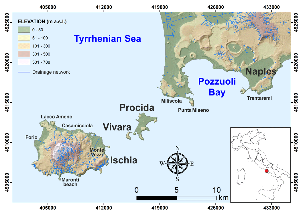
Figure 1Location (red dot in the inset map) and shaded relief of the Campi Flegrei volcanic area including the islands of Ischia, Procida, and Vivara (coordinates in EPSG 32633). The shaded relief has been developed from elevation data of the SIT Regione Campania (for reference see the main text).
The Campi Flegrei (Fig. 1) is an active volcanic area located in southern Italy within the central part of the Campanian Plain, a graben-like structure that resulted from the tectonic displacement of a Mesozoic carbonate basement. The Campi Flegrei corresponds to a quasi-circular depression extending for about 200 km2, a large part of which develops off Pozzuoli Bay (Sacchi et al., 2011, 2020). The insular sector is represented by the islands of Ischia, Procida, and Vivara (Fig. 1).
The most ancient volcanic activity is associated with the volcanism of Ischia, probably starting earlier than 150 ka (Poli et al., 1987; Vezzoli, 1988), whereas the activity of the island of Procida occurred mostly around 70 ka (De Astis et al., 2004). The emplacement of the Mt. Epomeo Green Tuff Formation (about 55 ka; Vezzoli, 1988) formed the backbone of the highest relief in the area (actually 788 m a.s.l. on the island of Ischia). At about 39 ka, the catastrophic eruption of the Campanian Ignimbrite took place, causing the formation of a large caldera (Rosi and Sbrana, 1987; Orsi et al., 1996; Perrotta et al., 2006) that was reshaped by the more recent phreatoplinian eruption of the Neapolitan Yellow Tuff (NYT), dated at 15 ka (Scarpati et al., 1993; Insinga et al., 2004; Deino et al., 2004). The volcanic activity that occurred after the NYT eruption was subdivided into three main epochs (Di Vito et al., 1999), which were interrupted by long periods of quiescence. In these epochs, minor explosive events occurred within the rim of the NYT caldera, creating at least 52 monogenic phreatomagmatic vents, including tuff rings, tuff cones, cinder, and spatter cones (Di Vito et al., 1999; Insinga et al., 2006; Perrotta et al., 2011). The latest eruption, known as the “Monte Nuovo eruption”, occurred in 1538 CE. Currently, the Campi Flegrei is characterized by very high levels of volcanic risk due to many towns lying in a caldera characterized by unrest conditions, as demonstrated by widespread fumaroles, thermal springs, earthquakes, and ongoing ground deformation.
The current geomorphological configuration of the continental and insular sectors of the Campi Flegrei is the result of volcanic and geomorphic processes that occurred in the last 15 kyr, after the NYT eruption. Relics of volcanic edifices partially dismantled by sea erosion and landslides can be found along or near the present coastline and in the submarine part of the NYT caldera (e.g., Sacchi et al., 2009, 2011). Landslides due to earthquakes, rainstorms, marine erosion, or human actions have repeatedly affected the slopes of the inland volcanos, ravines, and streams, as well as the steep scarps of gullies and coastal cliffs through time (Ducci and Napolitano, 1994; Guadagno and Mele, 1995; Mele and Del Prete, 1998; Del Prete and Mele, 1999, 2006; De Vita et al., 2006; Santo et al., 2012; Esposito et al., 2018b, 2020). Besides volcanic morphologies, the geomorphic setting of Campi Flegrei also includes lowlands that are located between volcanic edifices or close to the NYT caldera rims.
The drainage network is mostly arranged in radial patterns typical of volcanic edifices, with isolated short channels along gentle slopes and plains. Vegetation covering the volcanic hillslopes consists mainly of Mediterranean shrubs that alternate with vineyards and cultivated areas and locally with pine woods. In addition to climatic conditions described in the following section, the widespread vegetation is fostered also by fertile soils (andosols) developed from pyroclastic deposits.
Currently, the study area is inhabited by approximately 500 000 people, with an average population density of 3440 people per square kilometer. Besides, it is visited each year by thousands of tourists due to the archeological, cultural, and environmental attractions.
Weather and climate
The study area is characterized by a Mediterranean climate with hot, dry summers and moderately cool rainy winters. Mean annual temperatures are in the range of 10 ∘C at the hilly altitudes, 18 ∘C along the coastline, and 15.5 ∘C in the plains surrounding the inland reliefs (Ducci and Tranfaglia, 2005). The mean temperature of the warmest month (July) ranges between 24–28 ∘C, whereas the mean temperature of the coldest month (January) ranges between 4–6 ∘C. The rainfall regime is characterized by the maximum amounts in autumn and winter, with a mean annual precipitation of about 700 mm. It is worth noting that during the summer and autumn seasons, the coastal sector is often hit by convective cells forming offshore. Such cells are able to release high amounts of rain in short times, with maximum 10 min rain rates higher than 100 mm h−1, as highlighted by Esposito et al. (2015) and Fortelli et al. (2019). Waterspouts in front of the Flegrean coast are also associated with these cells. Winds blow mainly from three directions: west, northeast, south. They can reach wind gusts up to 140 km h−1 in the winter season, able to generate sea storms leading to severe damage to coastal settlements (Fortelli et al., 2021).
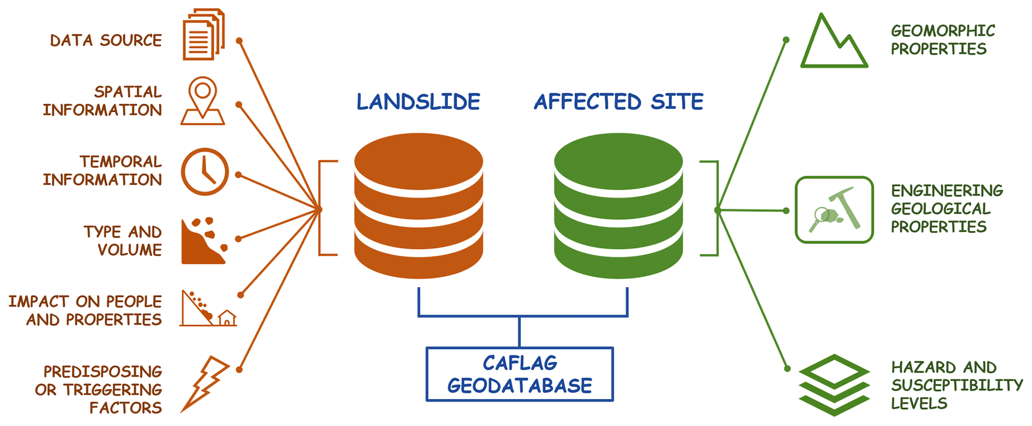
The CAFLAG geodatabase refers to the Campi Flegrei area (Fig. 1), extending about 230 km2 and including the western part of the city of Naples and the islands of Ischia, Procida, and Vivara. An overview of the attributes associated with each cataloged landslide event is shown in Fig. 2. Information related to both landslide (i.e., data source, localization, date of occurrence, type of movement, volume of displaced material, impact on people and properties, predisposing and triggering factors) and the corresponding affected site (i.e., geomorphological and engineering geological properties, landslide susceptibility, and hazard levels) is provided where available.
3.1 Landslide data sources
All the considered landslide data sources are listed as follows. The first seven sources can be considered “archive” sources, whereas the last two are “new” sources:
-
IFFI landslide inventory map (Inventario Fenomeni Franosi in Italia) (Trigila et al., 2010) (http://www.progettoiffi.isprambiente.it/en/, last access: 26 May 2022);
-
AVI catalog (Aree Italiane storicamente Vulnerate da calamità geologiche ed idrauliche) (http://sici.irpi.cnr.it/avi.htm, last access: 26 May 2022);
-
landslide database and inventory map of the hydrographic basin authority (AdB) (namely Campania Centrale Basin Authority) (http://www.distrettoappenninomeridionale.it/index.php/ elaborati-di-piano-menu/bacini-reg-nord-occidentali-bacino-reg-sarno-ex-adb-reg-campania-centrale-menu/piano-assetto-idrogeologico-rischio-da-frana-menu, last access: 26 May 2022);
-
Geological Map of Italy – CARG (Carta Geologica d'Italia) project (Sheets 446–447, 464, 465; 1:25 000–1:50 000 scale) (http://www.isprambiente.gov.it/Media/carg/campania.html, last access: 26 May 2022);
-
landslide inventories of the city of Naples (Calcaterra et al., 2002, 2003b, 2007; Di Martire et al., 2012);
-
seismically induced landslide inventory of the island of Ischia (Caccavale et al., 2017; Rapolla et al., 2012);
-
scientific papers (Beneduce et al., 1988; Calcaterra et al., 2003a, 2010; Di Nocera et al., 2007; Santo et al., 2012);
-
field geomorphological surveys performed on coastal sectors during 2013–2018, documented by Esposito et al. (2015, 2017, 2018b, 2020) and Caputo et al. (2018);
-
landslide reports collected from digital archives of the principal newspapers and news websites in the study area (https://napoli.repubblica.it/, last access: 8 March 2023; http://www.ilmattino.it, last access: 8 March 2023; http://www.cronacaflegrea.it, last access: 8 March 2023; http://www.montediprocida.com, last access: 8 March 2023; http://www.freebacoli.net, last access: 8 March 2023).
All of the events contained in the CAFLAG geodatabase are geocoded in a point shapefile, with each point referring to the centroid of the landslide scar. Pre-existing catalogs (IFFI, AVI, AdB) were available in shapefile formats so that each event was already associated with a georeferenced point. The other sources instead provided static map images requiring a manual digitalization of the location points or information allowing for placing the representative point on the corresponding hillslope by using as support the WMS services of the SIT Regione Campania WebGIS (https://sit2.regione.campania.it/content/servizi-wms, last access: 26 May 2022), such as (i) topographic map at 1:5000 scale, (ii) the derived digital terrain model (DTM) with a pixel size of 5 m, and (iii) an orthophoto at 1:10 000 scale. All these datasets refer to the years 2004–2005.
Given that the used sources included sometimes redundant events, a preliminary data filtering was performed manually by deleting those characterized by the same attributes and location, indicating therefore the same landslide event. Generally, the level of completeness of information associated with the collected events is quite heterogeneous, as well as the level of accuracy, as explained in the following section.
3.2 Geodatabase structure
Attributes associated with the landslide events of the CAFLAG geodatabase (Fig. 2) are specified in Table 1. The primary set of information refers to data sources and spatial and temporal properties of the events with related accuracy. High spatial accuracy was attributed to events associated with accurate geographical information, as for example accurate spatial coordinates provided in available databases, with indications about the affected road section, specific buildings, or sites. Where this type of information was not available, a low spatial accuracy was indicated, providing rough coordinates of the landslide-affected site (e.g., center of the locality, road or beach hit by the mass movement). High temporal accuracy was attributed to events associated with a complete date (i.e., dd/mm/yyyy), moderate accuracy to events characterized by both month and year of occurrence, and low accuracy to events which could be placed in a wide period of time before or within a specific year. The movement type (fall, flow, slide, complex) and the involved material (earth, debris, rock) were defined according to the classification of Cruden and Varnes (1996). Further attributes describe the impact of the cataloged landslides on people, buildings, and infrastructure, as well as, in a few cases only, indications about the factors predisposing or triggering the mass movements (e.g., rainfall, digging activities).
A secondary set of information refers to geomorphological properties of the landslide-affected sites, such as (i) type and name of the affected watersheds; (ii) geomorphological context in terms of inner slope (i.e., not related to direct sea action), coastal slope, or quarry; and (iii) morphometric properties of the affected hillslopes (elevation, slope, aspect), calculated from the intersection of each vector point with the DTM. By overlapping the point shapefile with engineering geological maps available for the area (Caccavale et al., 2017; Sacchi et al., 2015), both geotechnical and seismic properties of lithotypes involved in the landslides were obtained, as well as the landslide hazard and susceptibility levels of the sites, extracted from the landslide risk plan of the Campania Centrale Basin Authority (http://www.distrettoappenninomeridionale.it/index.php/ elaborati-di-piano-menu/bacini-reg-nord-occidentali-bacino-reg-sarno-ex-adb-reg-campania-centrale-menu/piano-assetto-idrogeologico-rischio-da-frana-menu, last access: 26 May 2022).
All the statistical analyses were performed by means of the Microsoft™ Excel software, and results were displayed in a series of histograms and pie charts. Statistics related to deadly events, based on the frequency–number (F–N) relations, were aimed at analyzing the societal risk by following the work of Cascini et al. (2008).
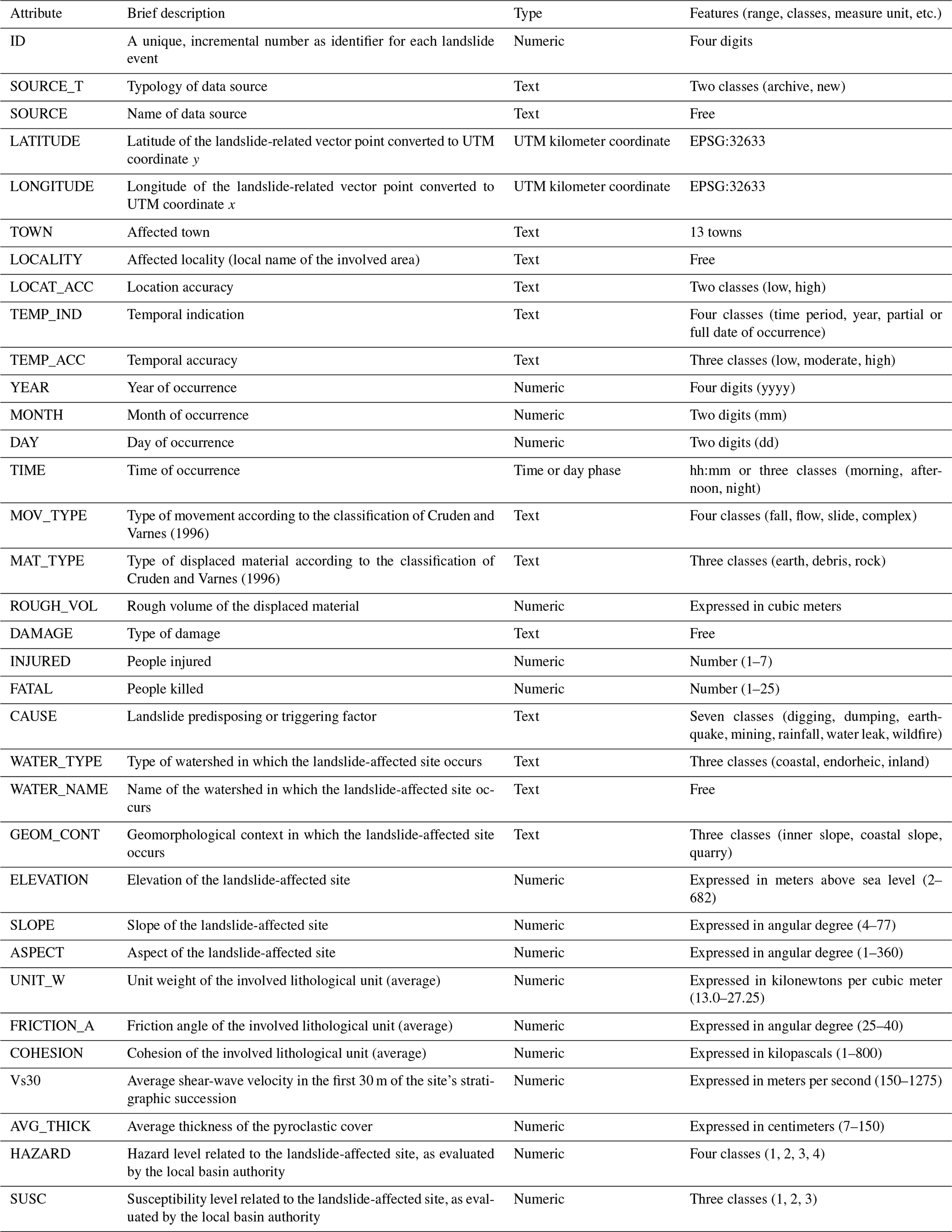

Figure 3Map of the cataloged landslides, classified according to the type of movement (coordinates in EPSG 32633).
The CAFLAG geodatabase encompasses 2302 landslides that occurred throughout the continental, coastal, and insular sectors of the Campi Flegrei during the 1828–2017 time span (Fig. 3). The number of landslides characterized by a highly accurate position is 2122 (about 92 % of the total). The number of those with a temporal accuracy ranging from moderate to high is 482, corresponding to about 21 % of the total. Statistics presented in the following sections describe some general features of the collected data which are useful to characterize the landslide phenomena in the area.
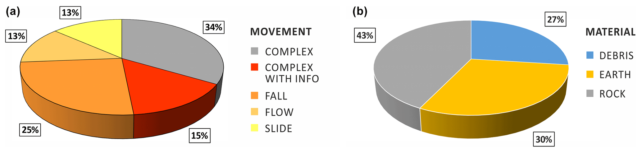
Figure 4Landslide events classified according to the type of movement (a) and displaced material (b).
4.1 Landslide general features
In this section, statistical distributions of the landslide movement types, displaced material, and displaced volume are described. Data in Fig. 4 highlight that most of the cataloged landslides are characterized by a complex movement (1115). Among them, specific information about the failure mechanism is available for 343 complex landslides only (15 %), whereas no indication is available for the other 772 (34 %). The most recurrent movement type among the non-complex landslides is fall (621 events – 25 %), which is slightly more frequent than slide and flow types (13 % each).
Examples of rock falls are shown in Fig. 5. These failures are quite frequent along both the coastal and inner tuffaceous cliffs, determining episodic and localized cliff retreats that pose a serious risk to buildings and people living near to the cliff tops. These are able to displace huge rock masses, mobilizing up to thousands of cubic meters of volcaniclastic rocks.
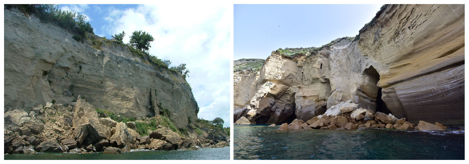
Figure 5Examples of rock fall affecting the Campi Flegrei coastal cliffs: Punta Miseno (2015) on the left and Trentaremi–Capo Posillipo (2017) on the right (both sites are indicated in Fig. 1) (image credits: Alessandro Fedele, INGV).
Figure 6 shows instead a series of rainfall-induced shallow landslides displacing unconsolidated pyroclastic deposits and soils. Images refer to two different events affecting Monte Vezzi (island of Ischia) in April 2006 and the coastal slope of Monte di Procida in 2010. Rocky cliffs like those represented in Fig. 5 are the most affected by landslides (43 %), whereas slopes covered by soils and fine pyroclastic deposits (earth) (see examples in Fig. 6) are affected by 30 % of the events. Coarser pyroclastic deposits or ancient landslide and debris deposits are those less involved with mass movements (27 %) (Fig. 4).
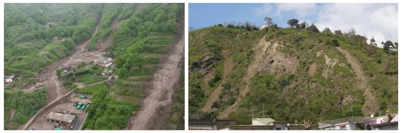
Figure 6Examples of flow-like mass movements at Monte Vezzi on the island of Ischia (2006) on the left and at Miliscola–Monte di Procida (2010) on the right (both sites are indicated in Fig. 1) (image credits: Nucleo elicotteri Vigili del Fuoco Salerno; Paola Romano).
Volumetric data are available for 277 landslides (Fig. 7), corresponding to about 12 % of the whole dataset. Values range from 1 to 7500 m3 with a mean of about 123 m3 per event. About 40 % of the 277 landslides displaced a volume smaller than or equal to 10 m3 and 23 % a volume larger than or equal to 100 m3. As shown in Fig. 7, the sharp break in the curve slope located at around 10 m3 highlights that landslides with volumes below this value are strongly underestimated. This is likely due to the missed reporting of minor landslides, which often do not cause damage or casualties.
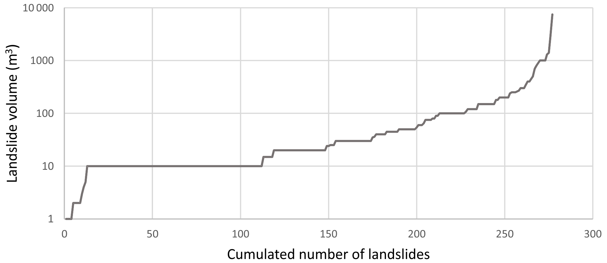
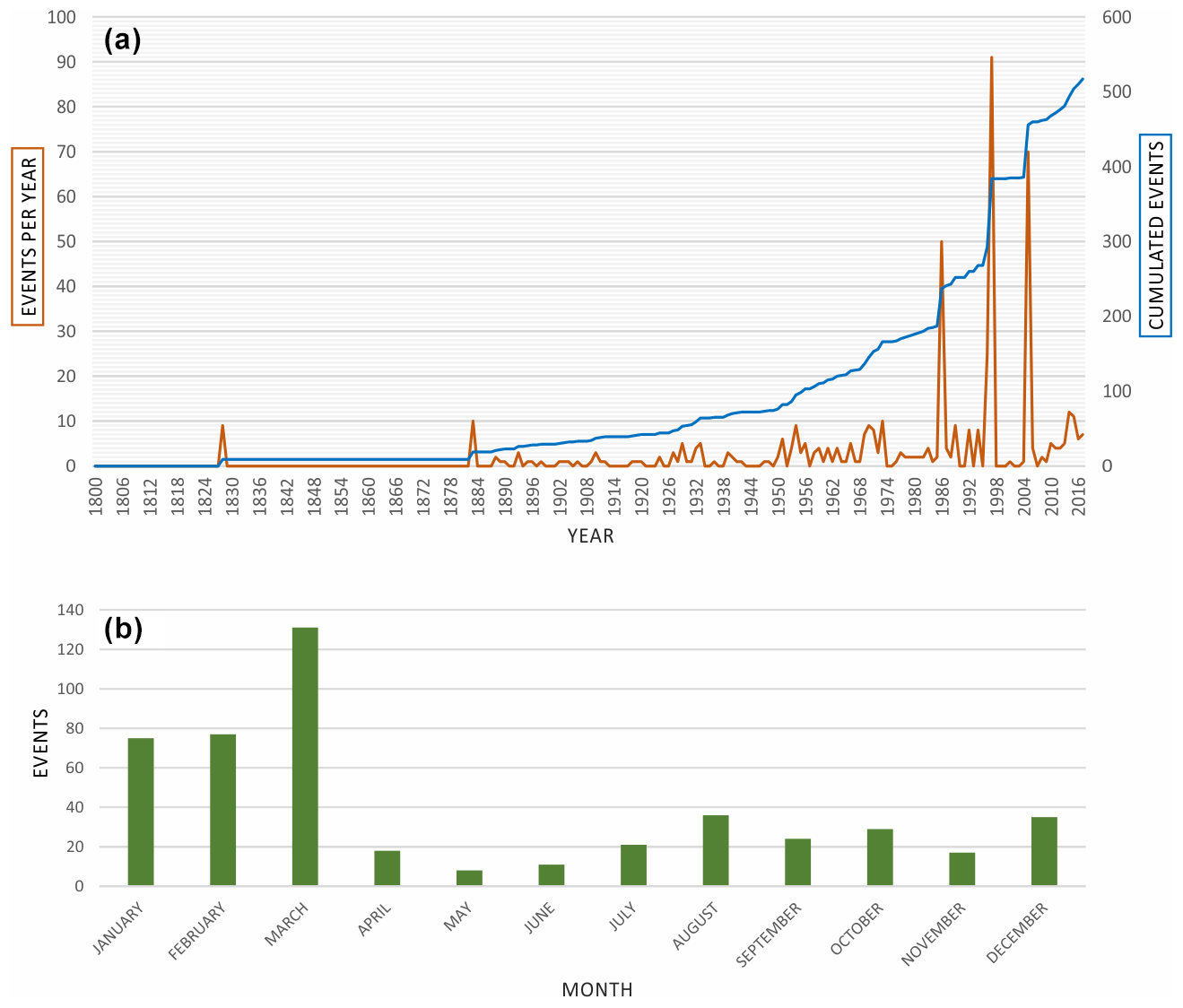
Figure 8Yearly (a) and monthly (b) distribution of the landslide events characterized by temporal information.
4.2 Temporal distribution
The year of occurrence is known for 517 landslides only, with monthly information available for 482 of them. Incompleteness of historical information in the first half of the analyzed period results in a yearly trend (Fig. 8a) characterized by a misleading linear increase in the number of landslides. On the other hand, peaks in the years 1986, 1997, and 2005 (i.e. 50, 91, and 70 events, respectively) that exceed significantly the average value of 2.4 events per year can be considered realistic because they occurred in the period (i.e., between 1985 and 2017) with the highest availability of documentary sources. In this period, the annual frequency assumes an almost constant average value of 9.9 events per year. Regarding the seasonality, most of the events occurred in the winter season, and specifically in the months from January to March, even if a number of events occurred also in the late summer–fall months (Fig. 8b).
4.3 Deadly impact and societal risk
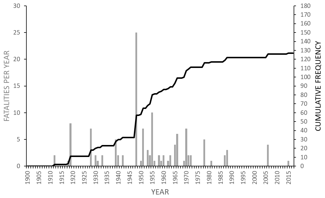
According to the information collected in the CAFLAG geodatabase, 127 people lost their lives as a consequence of 53 fatal landslides that occurred in the 105-year period (1912–2017) with an average rate of 1.2 fatalities per year. The temporal distribution of fatalities is represented in Fig. 9; here, the cumulative curve has a stepped shape in a broader concave (downward) trend, and its slope increases corresponding to significant events in terms of fatalities, such as the landslide of 1948, corresponding to the deadliest within the analyzed time period (25 fatalities). Since the early 1980s, the average frequency of fatalities per year decreased from 1.7 (related to the time span 1910–1980) to 0.3, as highlighted by a gentler slope of the cumulative curve. This reduction in the trend, also documented at national scale (Rossi et al., 2019; Esposito et al., 2023), can be due to the increased resilience of local communities based on new technologies and prevention measures, as well as on a higher awareness about the risk posed by geo-hydrological processes.
In order to analyze the societal risk posed by landslides in the study area since 1912, the F–N curve was developed for both continental and insular sectors and compared with the F–N curve realized by Cascini et al. (2008) for a larger area of the Campania region characterized by pyroclastic deposits covering a volcanic substratum (lava and tuff). This curve represents the cumulative probability per year (F) that landslides will cause N or more fatalities versus the number of fatalities resulting from landslides (Fell and Hartford, 1997). The F–N curve in Fig. 10 is characterized by a relatively high slope owing to the great number of incident data which refer to landslide events resulting in no more than 25 fatalities and by the lack of data from before 1912, which are not considered in this study. The curve obtained for the study area (Fig. 10) shows that the societal risk posed by landslides is very high when compared to that estimated by Cascini et al. (2008) for the whole volcanic areas of the Campania region. The two curves show a similar behavior until N=10. After that point, the curve of Cascini et al. (2008) goes down towards lower F values controlled by fatalities in the interval , which do not occur in this study. This result can be of particular concern for public authorities in charge of landslide risk mitigation by defining acceptable and tolerable landslide risk thresholds for society. Generally, as recognized for the whole Campania territory (Cascini et al., 2008), anthropogenic factors represent the most important triggering cause of landslides associated with no more than three fatalities, while critical rainfall is able to trigger also landslides with worse consequences in terms of fatalities (e.g., landslides of 26 November 2022 at Casamicciola – 12 fatalities).
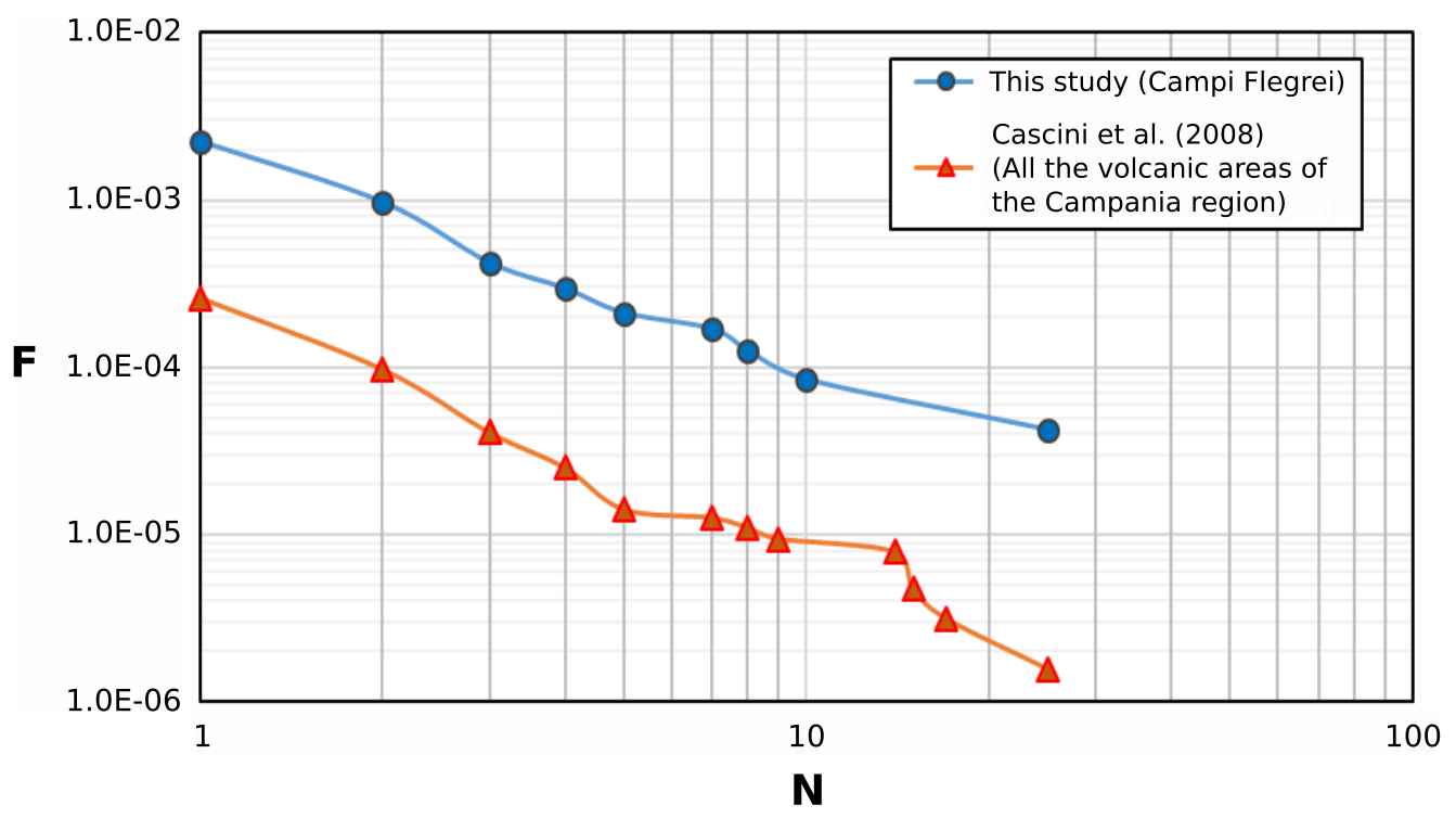
Figure 10F–N curve of the Campi Flegrei study area compared with the F–N curve developed by Cascini et al. (2008) for a larger area of the Campania region, encompassing the Campi Flegrei, Vesuvius, and Roccamonfina volcanic sectors. F is the annual frequency of events causing N or more fatalities. The two curves have been normalized for the areal extension of the investigated areas (1741 km2 for the whole volcanic areas of the region and 230 km2 for the Campi Flegrei study area).
4.4 Geomorphic and engineering geological properties of the affected hillslopes
Statistics related to the 2122 landslides characterized by an accurate location (high) show that 53 % of them occurred in steep terrains characterized by slope angles ranging from 30 to 77∘, whereas 47 % occurred on gentler slopes characterized by slope angles lower than 30∘. The highest absolute frequency of events occurs in the slope class from 30 to 40∘ (22 %); the highest densities (events km−2) occur in the classes 50–60∘ (92 events km−2) and 60–70∘ (97 events km−2) (Fig. 11).
Aspect data in Fig. 11 show the highest density of landslides along slopes exposed towards the northwest direction (i.e., 315–360∘) and the highest absolute frequency in the aspect class from 225 to 270∘. A lower frequency of events occurs instead for slopes exposed towards the east. This can be linked to the direction from which the rainstorms associated with low-pressure systems usually came from, such as the Tyrrhenian Sea (Fig. 1) located to the west of the study area (Saviano et al., 2019; Fortelli et al., 2019).
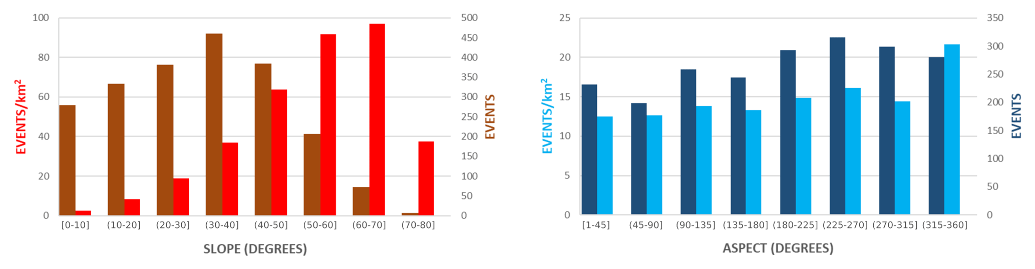
Figure 11Distribution of the landslide events according to the slope gradient and aspect of the affected hillslopes.
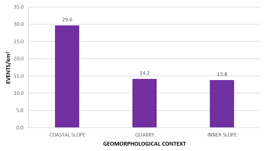
Most of the landslides occurred along the inner hillslopes (78 %), about 21 % affected coastal cliffs, and 1 % occurred along quarry cliffs. On the other hand, by considering the relative area of these three geomorphological contexts, the highest concentration of landslides can be found along the coastal sector (Fig. 12), confirming the strongly active coastal dynamics in the study area, as deduced also from the coastal cliff retreat rates (Esposito et al., 2018b).
Statistics of the geotechnical properties characterizing lithologies involved in 2106 mass movements reveal a concentration of records (92 %) corresponding to average unit weights typical of volcaniclastic deposits in a range from 13 to 17 kN m−3 (Fig. 13a). A few (8 %) displaced lithologies are characterized by higher values, corresponding to lavas and other solid rocks outcropping in the area. The histogram of the friction angle highlights values typical of pyroclastic rocks (Caccavale et al., 2017, and reference therein) ranging from 25 to 40∘, depending on the degree of density and mineral composition, with the highest frequency in the ranges from 25 to 31∘ (Fig. 13b). At the same time, cohesion also concentrates in the typical interval of weakly welded pyroclastic deposits and specifically below 50 kPa, whereas higher values refer to the most lithified rocks (Fig. 13c).
The statistical distribution of the Vs30 parameter indicates that 73 % of landslide-affected (out of 2078) lithologies are characterized by low Vs30 values, ranging from 100 to 400 m s−1 (Fig. 13d), which can be explained by weak geotechnical properties of the pyroclastic deposits documented in the area (e.g., Rowley et al., 2021; Albano et al., 2018; Caccavale et al., 2017).
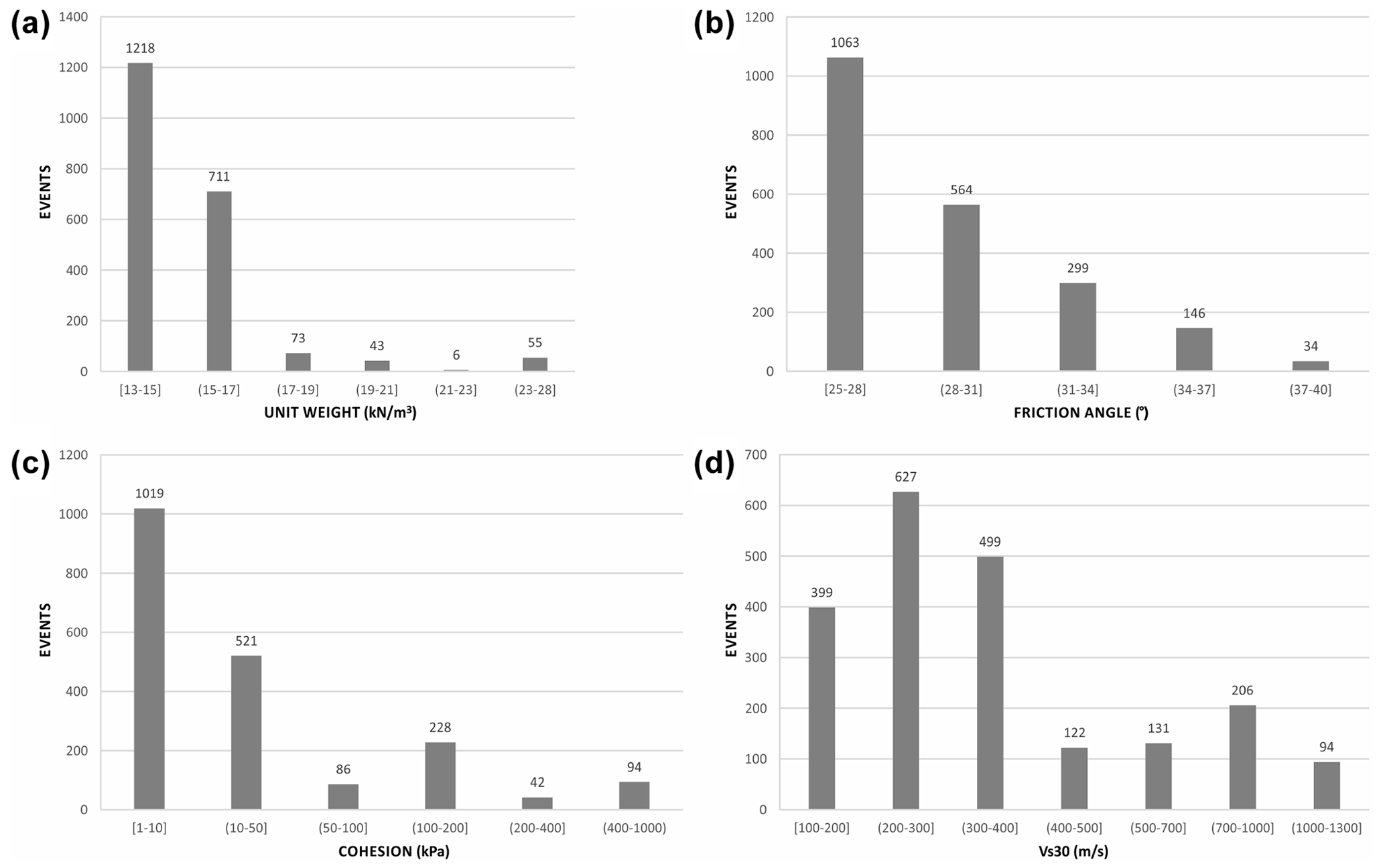
Figure 13Distribution of the landslide events according to the unit weight (a), friction angle (b), cohesion (c), and Vs30 (d) of the displaced lithologies.
4.5 Limitations of the CAFLAG geodatabase
Historical landslide catalogs are commonly affected by incompleteness and biases resulting from the type of sources used to collect information (Pereira et al., 2014). These limitations are usually of unknown effect or seriousness, and there are no general data analysis rules for eliminating them (Ibsen and Brunsden, 1996). The analysis of the completeness of historical catalogs of natural events is almost always difficult (Rossi et al., 2010), and, in the case of landslides, it depends on the assessment of the fraction of mass movements in an inventory compared to the real number of events in the study area (Guzzetti et al., 2012). The CAFLAG geodatabase refers to a relatively small geographical area with respect to other published regional or national historical landslide databases, like those listed by Bíl et al. (2021). On one side, this reduces the biases in the spatial accuracy and completeness of the geodatabase. In fact, 92 % (2122) of the 2302 records are characterized by high spatial accuracy, highlighting an adequate localization of the recorded landslides. At the same time, the spatial completeness can be considered relatively high since many small and isolated events are also reported. In addition, indirect evidence of the high completeness of the CAFLAG geodatabase can be derived from a comparison with other databases covering comparable time ranges and even larger spatial extents. For example, Devoli et al. (2007) cataloged 132 historical landslides that occurred in Nicaragua in the time period 1826–1988 (162 years); Elliott and Kirschbaum (2007) realized a preliminary database covering the state of Utah (USA), encompassing 356 landslide occurrences from 1850 to 1978 (128 years); Laprade et al. (2000) reported 1326 landslides which occurred between January 1890 and June 1999 (109 years) in Seattle (USA); and Pereira et al. (2014) reported 628 landslides in northern Portugal in the period 1900–2010 (110 years). All these databases report a lower number of records compared to those (no. 2302) within the CAFLAG geodatabase. Besides this, it is worth noting that the completeness of the CAFLAG geodatabase is certainly poor in those areas where the population density is low, such as coastal cliffs or areas close to the craters of volcanic edifices (Fig. 3).
An evident bias affects the temporal information. In fact, there are only 344 (15 %) landslides with a high temporal accuracy (i.e., dd/mm/yyyy), whereas most are characterized by low accuracy (79 %) and the remaining part by moderate accuracy (6 %). Such a bias depends on the usage of geomorphological inventories developed mostly by means of the visual interpretation of aerial photographs (e.g., IFFI, inventory map of the AdB, CARG project) which do not allow for determining accurate temporal information on the occurrence of landslides (Trigila et al., 2010). In addition, the steady growth of the number of reported landslides over time, shown in Fig. 8a, is ostensibly controlled by an increased availability of documental sources rather than a real rise in mass movements, as observed at both national scale (Guzzetti and Tonelli, 2004) and in other Italian regions (Salvati et al., 2009; Piacentini et al., 2018). On the other hand, peaks recorded in the years 1986, 1997, and 2005 characterized by 50, 91, and 70 events, respectively, are likely due to a particularly high landslide activity and require an in-depth analysis.
Information on the displaced volumes is available for 12 % of the events, whereas the type of damage is reported for 41 events only, representing further limitations in the magnitude information reported within the CAFLAG geodatabase.
The CAmpi Flegrei LAndslide Geodatabase (CAFLAG) is freely available in the 4TU.ResearchData repository at https://doi.org/10.4121/14440757.v2 (Esposito and Matano, 2021).
Historical catalogs represent unique information to inspect the extent, types, pattern, recurrence, and statistics of slope failures in a given territory (Guzzetti et al., 2012). In volcanic landscapes, these catalogs are even more necessary to reach a comprehensive knowledge about the role played by landslides in the geomorphic evolution of these settings and about processes that lead to slope failures and control their spatial variations (Yano et al., 2019). As highlighted by data reported within the CAFLAG geodatabase, weak geotechnical properties of the volcanic lithotypes (Fig. 13) coupled with a rough topography play a relevant role in predisposing volcanic hillslopes to mass-wasting processes. This should be demonstrated also with numerical analyses by exploiting the twofold contributions provided by the CAFLAG geodatabase, consisting of data related to both landslide processes and geo-environmental properties of the affected sites which can be exposed to new instabilities. These two types of information coincide in fact with inputs required by statistically based landslide susceptibility models, namely “dependent” and “explanatory” variables, respectively (Reichenbach et al., 2018). Therefore, data of the CAFLAG geodatabase may be aimed at calibrating or validating statistical models resulting in landslide susceptibility and hazard maps which, in the study area, may complement the official hazard zonation.
The high spatial accuracy of the cataloged records, detailed information on typologies, and morphometric and geotechnical properties of the affected sites thus provide a valuable opportunity to investigate the occurrence of landslides in relation to other geo-environmental predisposing or triggering factors. For instance, analyses described in the previous sections highlight that mass-wasting processes are concentrated along the coastal sector. Collapses of the coastal cliffs can be considered the most important agents leading to cliff retreat in the area, since these are able to remove large volumes of rocks in short times (Esposito et al., 2017, 2018b). The CAFLAG geodatabase could thus be exploited to assess susceptibility of the rocky coastline against marine erosion or risk conditions affecting the widespread anthropic settlements and the people located there.
Statistics show that rocky slopes formed by lithified volcanic rocks, such as tuff or ignimbrite, were mostly affected by rock falls. In the coastal area, this was documented by Ducci and Napolitano (1991), who analyzed the cliff failures along the coastline of the island of Procida, observing that all of the identified collapses were rock falls and topples involving tuffaceous formations. Similar results were achieved by Del Prete and Mele (1999) for the cliffs of the island of Ischia. In the inland areas, however, many landslides affected the walls of old and abandoned quarries or digging fronts (Calcaterra et al., 2007). Discontinuity systems characterizing rock masses play a fundamental role in predisposing rocky slopes to failure processes, as well as in controlling the volume of the mobilized rocks (Matano et al., 2016). In the study area, discontinuities consist of faults, joints, and fractures associated with volcano-tectonic processes (Vitale and Isaia, 2014). Other failure-predisposing factors include geotechnical properties (e.g., low cohesion in Fig. 13) and weathering processes typical of the Flegrean area, such as the zeolitization and argillification of pyroclastic rocks. Water circulation, earthquakes, sea wave action, or anthropic vibrations and excavations can be considered among the main triggering factors. Besides the dominance of landslides involving solid rocks, the shallow sliding of loose pyroclastic deposits (i.e., pumices, scoria, ashes, and lapilli) and soils covering the lithified formations is also frequent. Commonly, these failures start as translational slides and evolve into debris or hyperconcentrated flows within gullies or into debris avalanches along the steep open slopes (Fig. 6) (Calcaterra et al., 2003b). Intense rainfall represents the triggering factor of the initial slide. Elevated slope angles and geotechnical properties of the involved material (Fig. 13) lead to a rapid or very rapid evolution in flow processes, as observed in the recent event of Casamicciola.
Many events affected hillslopes exposed towards the west, north, and south. This may be explained by the frequent impact of these hillslopes with convective cells and low-pressures systems coming from the Tyrrhenian Sea (Saviano et al., 2019). These meteorological structures are able to release high amounts of rainfall causing also flash flood processes (e.g., Esposito et al., 2015, 2018a) and are often associated with strong winds and storm surges damaging coastal infrastructures, as documented in the city of Naples in 2020 (Fortelli et al., 2021).
Another relevant finding of the current analysis is that in the analyzed time period, 53 landslide events caused 127 fatalities with an average rate of 1.2 fatalities per year (Fig. 9). Most of the people died in the city of Naples, hit by rocky blocks detached from steep tuffaceous slopes; others died because of flow-like mass movements, recurring mostly on the island of Ischia (e.g., Santo et al., 2012). The intense urbanization of the area developed after the Second World War determined an increase in fatal landslides (Fig. 9) and risk conditions in a way that, as highlighted also by the F–N curve (Fig. 10), landslides in the area represent a relevant societal risk. Data contained in the CAFLAG geodatabase may be thus exploited for applications aimed at planning countermeasures for the landslide risk reduction.
GE and FM collected and processed the data. GE prepared the first draft of the paper. FM edited and integrated the text at several stages, supervising the research activity.
The contact author has declared that neither of the authors has any competing interests.
Publisher's note: Copernicus Publications remains neutral with regard to jurisdictional claims in published maps and institutional affiliations.
A first draft of the geodatabase was developed within the research project PON MONICA funded by the Italian Ministry of Education, University and Research (grant number PON01_01525 – coordinator of the CNR-IAMC research unit: Marco Sacchi; national coordinator: Giuseppe De Natale – INGV). We are grateful to the editor and four anonymous referees for their constructive comments that helped us to improve the content, quality, and readability of the work.
This paper was edited by Giulio G. R. Iovine and reviewed by four anonymous referees.
Ablay, G. and Hürlimann, M.: Evolution of the north flank of Tenerife by recurrent giant landslides, J. Volcanol. Geoth. Res., 103, 135–159, 2000.
Albano, M., Saroli, M., Montuori, A., Bignami, C., Tolomei, C., Polcari, M., Pezzo, G., Moro, M., Atzori, S., Stramondo, S., and Salvi, S.: The Relationship between InSAR Coseismic Deformation and Earthquake-Induced Landslides Associated with the 2017 Mw 3.9 Ischia (Italy) Earthquake, Geosciences, 8, 0303, https://doi.org/10.3390/geosciences8080303, 2018.
Ardizzone, F., Bucci, F., Cardinali, M., Fiorucci, F., Pisano, L., Santangelo, M., and Zumpano, V.: Geomorphological landslide inventory map of the Daunia Apennines, southern Italy, Earth Syst. Sci. Data, 15, 753–767, https://doi.org/10.5194/essd-15-753-2023, 2023.
Beneduce, P., D'Elia, G., and Guida, M.: Morfodinamica dei versanti dell'area flegrea (Campania): erosione in massa ed erosione lineare, Memorie della Società Geologica Italiana, 41, 949–961, 1988.
Bíl, M., Raška, P., Dolák, L., and Kubeček, J.: CHILDA – Czech Historical Landslide Database, Nat. Hazards Earth Syst. Sci., 21, 2581–2596, https://doi.org/10.5194/nhess-21-2581-2021, 2021.
Caccavale, M., Matano, F., and Sacchi, M.: An integrated approach to earthquake-induced landslide hazard zoning based on probabilistic seismic scenario for Phlegrean Islands (Ischia, Procida and Vivara), Italy, Geomorphology, 295, 235–259, 2017.
Calcaterra, D. and de Luca Tupputi Schinosa, F.: The February 28, 1868 Mt. Echia rockfall in the framework of the historical and present-day landslide activity at Naples, Italy, Geophys. Res. Abstr., 8, 04708, 2006.
Calcaterra, D., de Riso, R., Nave, A., and Sgambati, D.: The role of historical information in landslide hazard assessment of urban areas: the case of Naples (Italy), Proc. 1st European Conference on Landslides, 129–135, Swets & Zeitlinger, Lisse, the Netherlands, ISBN 905809393X, 2002.
Calcaterra, D., Del Prete, S., and Mele, R.: L'influenza dei fenomeni franosi sugli insediamenti costieri del Distretto Flegreo, Proc. CITTAM 2003, 26–28 June 2003, Napoli, Arte Tipografica Editrice, Napoli, Italy, 524–534, 2003a.
Calcaterra, D., de Riso, R., Evangelista, A., Nicotera, M. V., Santo, A., and Scotto Di Santolo, A.: Slope instabilities in the pyroclastic deposits of the Phlegraean district and the carbonate Apennine (Campania, Italy), International Workshop on Occurrence and Mechanisms of Flows in Natural Slopes and Earthfills, Iw-Flows 2003, Sorrento, 14–16 May, 1–9, 2003b.
Calcaterra, D., Coppin, D., de Vita, S., Di Vito, M. A., Orsi, G., Palma, B., and Parise, M.: Slope processes in weathered volcaniclastic deposits within the city of Naples: the Camaldoli Hill case, Geomorphology, 87, 132–157, 2007.
Calcaterra, D., de Luca Tupputi Schinosa, F., Evangelista, A., Ruopolo, S., and Scotto di Santolo, A.: Modeling of rainfall induced surficial slide-flows in the pyroclastic deposits of the Astroni crater (Phlegrean Fields), in: Proc. 1st Italian Workshop on Landslides “Rainfall-induced landslides: mechanisms, monitoring techniques and nowcasting models for early warning systems”, 8–10 June 2009, Naples, Italy, 2, 9–19, 2010.
Capra, L., Poblete, M. A., and Alvarado, R.: The 1997 and 2001 lahars of Popocatépetl volcano (Central Mexico): textural and sedimentological constraints on their origin and hazards, J. Volcanol. Geoth. Res., 131, 351–369, 2004.
Caputo, T., Marino, E., Matano, F., Somma, R., Troise, C., and De Natale, G.: Terrestrial Laser Scanning (TLS) data for the analysis of coastal tuff cliff retreat: application to Coroglio cliff, Naples, Italy, Ann. Geophys., 61, SE110, https://doi.org/10.4401/ag-7494, 2018.
Carrara, A., Cardinali, M., Guzzetti, F., and Reichenbach, P.: GIS technology in mapping landslide hazard, in: Geographical information systems in assessing natural hazards, edited by: Carrara, A. and Guzzetti, F., Kluwer, Dordrecht, the Netherlands, 135–175, 1995.
Casalbore, D., Passeri, F., Tommasi, P., Verrucci, L., Bosman, A., Romagnoli, C., and Chiocci, F. L.: Small-scale slope instability on the submarine flanks of insular volcanoes: the case-study of the Sciara del Fuoco slope (Stromboli), Int. J. Earth Sci., 109, 2643–2658, 2020.
Cascini, L., Ferlisi, S., and Vitolo, E.: Individual and societal risk owing to landslides in the Campania region (southern Italy), Georisk, 2, 125–140, 2008.
Chiocci, F. L., Romagnoli, C., Tommasi, P., and Bosman, A.: The Stromboli 2002 tsunamigenic submarine slide: Characteristics and possible failure mechanisms, J. Geophys. Res.-Sol. Ea., 113, B10102, https://doi.org/10.1029/2007JB005172, 2008.
Coombs, M. L., White, S. M., and Scholl, D. W.: Massive edifice failure at Aleutian arc volcanoes, Earth Planet. Sc. Let., 256, 403–418, 2007.
Cruden, D. M. and Varnes, D. J.: Landslides types and processes, in: Landslides: Investigation and mitigation, edited by: Turner, A. K. and Schuster, R. L., Transportation Research Board Representative 247, National Research Council, Washington, D.C., 36–75, 1996.
De Astis, G., Pappalardo, L., and Piochi, M.: Procida volcanic history: New insights into the evolution of the Phlegraean Volcanic District (Campania region, Italy), B. Volcanol., 66, 622–641, 2004.
Deino, A. L., Orsi, G., de Vita, S., and Piochi, M.: The age of the Neapolitan Yellow Tuff caldera-forming eruption (Campi Flegrei caldera-Italy) assessed by 40Ar/39Ar dating method, J. Volcanol. Geoth. Res., 133, 157–170, 2004.
Del Prete, S. and Mele, R.: L'influenza dei fenomeni di instabilità di versante nel quadro morfoevolutivo della costa dell'isola d'Ischia, Bollettino Società Geologica Italiana, 118, 339–360, 1999.
Del Prete, S. and Mele, R.: Il contributo delle informazioni storiche per la valutazione della propensione al dissesto nell'Isola d'Ischia (Campania), Rendiconti Società Geologica Italiana, 2, 29–47, 2006.
De Natale, G., Troise, C., Pingue, F., Mastrolorenzo, G., Pappalardo, L., Battaglia, M., and Boschi, E.: The Campi Flegrei caldera: Unrest mechanisms and hazards, Geological Society, London, Special Publications, 269, 25–45, 2006.
De Vita, S., Sansivero, F., Orsi, G., and Marotta, E.: Cyclical slope instability and volcanism related to volcano-tectonism in resurgent calderas: the Ischia island (Italy) case study, Eng. Geol., 86, 148–165, 2006.
De Vita, P., Di Clemente, E., Rolandi, M., and Celico, P.: Engineering geological models of the initial landslides occurred on the April 30th, 2006, at the Mount Di Vezzi (Ischia Island, Italy), Italian Journal of Engineering Geology and Environment, 2, 119–141, 2007.
Devoli, G., Strauch, W., Chávez, G., and Høeg, K.: A landslide database for Nicaragua: a tool for landslide-hazard management, Landslides, 4, 163–76, https://doi.org/10.1007/s10346-006-0074-8, 2007.
Di Martire, D., De Rosa, M., Pesce, V., Santangelo, M. A., and Calcaterra, D.: Landslide hazard and land management in high-density urban areas of Campania region, Italy, Nat. Hazards Earth Syst. Sci., 12, 905–926, https://doi.org/10.5194/nhess-12-905-2012, 2012.
Di Nocera, S., Matano, F., Rolandi, G., and Rolandi, R.: Contributo sugli aspetti geologici e vulcanologici di monte di Vezzi (isola d'Ischia) per lo studio degli eventi franosi dell'aprile 2006, Italian Journal of Engineering Geology and Environment, 2, 27–52, 2007.
Di Traglia, F., Roverato, M., Bonforte, A., and Gross, F.: Editorial: Flank dynamics, sector collapses, lahars, and rockfalls: analysis, monitoring, and modelling of small to large scale volcanic slope instability, Int. J. Earth Sci., 109, 2615–2618, 2020.
Di Vito, M. A., Isaia, R., Orsi, G., Southon, J., de Vita, S., D'Antonio, M., Pappalardo, L., and Piochi, M.: Volcanism and deformation since 12,000 years at the Campi Flegrei caldera (Italy), J. Volcanol. Geoth. Res., 91, 221–246, 1999.
Ducci, D. and Napolitano, P.: Le condizioni di stabilità delle coste dell'Isola di Procida (golfo di Napoli), Atti 1∘ Conv. Naz. Giovani Ric. in Geol. Appl., Ric. Scient. ed eucaz. perman., suppl. 93, 97–106, Milano, 1991.
Ducci, D. and Napolitano, P.: Franosità e caratterizzazione geomeccanica delle facies litoidi delle Formazioni di Solchiaro e Terra Murata (Procida), Geologica Romana, 30, 97–104, 1994.
Ducci, D. and Tranfaglia, G.: L'impatto dei cambiamenti climatici sulle risorse idriche sotterranee in Campania, Geologi, 1–4, 13–21, 2005.
Dufresne, A., Siebert, L., and Bernard, B.: Distribution and Geometric Parameters of Volcanic Debris Avalanche Deposits, in: Volcanic Debris Avalanches. Advances in Volcanology, edited by: Roverato, M., Dufresne, A., and Procter, J., Springer, Cham, https://doi.org/10.1007/978-3-030-57411-6_4, 2021.
Elliott, A. and Kirschbaum, M.: The preliminary landslide history database of Utah, 1850–1978, Utah Geological Survey, 514, 5, 2007.
Esposito, G. and Matano, F.: CAmpi Flegrei LAndslide Geodatabase (CAFLAG). 4TU.ResearchData [data set], https://doi.org/10.4121/14440757.v2, 2021.
Esposito, G., Fortelli, A., Grimaldi, G.M., Matano, F., and Sacchi, M.: I fenomeni di flash flood nell'area costiera di Pozzuoli (Napoli, Italia): risultati preliminari sull'analisi dell'evento del 6 novembre 2011, Rendiconti Online della Società Geologica Italiana, 34, 74–84, 2015.
Esposito, G., Salvini, R., Matano, F., Sacchi, M., Danzi, M., Somma, R., and Troise, C.: Multitemporal monitoring of a coastal landslide through sfm-derived point cloud comparison, The Photogrammetric Record, 32, 459–479, https://doi.org/10.1111/phor.12218, 2017.
Esposito, G., Matano, F., and Scepi, G.: Analysis of increasing flash flood frequency in the densely urbanized coastline of the Campi Flegrei volcanic area, Italy, Front. Earth Sci., 6, 63, https://doi.org/10.3389/feart.2018.00063, 2018a.
Esposito, G., Salvini, R., Matano, F., Sacchi, M., and Troise, C.: Evaluation of geomorphic changes and retreat rates of a coastal pyroclastic cliff in the Campi Flegrei volcanic district, southern Italy, J. Coast. Conserv., 22, 957–972, https://doi.org/10.1007/s11852-018-0621-1, 2018b.
Esposito, G., Parodi, A., Lagasio, M., Masi, R., Nanni, G., Russo, F., Alfano, S., and Giannatiempo, G.: Characterizing Consecutive Flooding Events after the 2017 Mt. Salto Wildfires (Southern Italy): Hazard and Emergency Management Implications, Water, 11, 2663, https://doi.org/10.3390/w11122663, 2019.
Esposito, G., Matano, F., Sacchi, M., and Salvini, R.: Mechanisms and frequency-size statistics of failures characterizing a coastal cliff partially protected from the wave erosive action, Rendiconti Lincei – Scienze Fisiche e Naturali, 31, 337–351, 2020.
Esposito, G., Salvati, P., and Bianchi, C.: Insights gained into geo-hydrological disaster management 25 years after the catastrophic landslides of 1998 in southern Italy, Int. J. Disaster Risk Reduc., 84, 103440, https://doi.org/10.1016/j.ijdrr.2022.103440, 2023.
Fell, R. and Hartford, D.: Landslide risk management, in: Landslide Risk Assessment, edited by: Cruden, D. M. and Fell, R., Proc. Int. Workshop Landslide Risk Assessment, Balkema, 51–109, 1997.
Fortelli, A., Scafetta, N., and Mazzarella, A.: Nowcasting and real-time monitoring of heavy rainfall events inducing flash-floods: an application to Phlegraean area (Central-Southern Italy), Nat. Hazards, 97, 861–889, 2019.
Fortelli, A., Fedele, A., De Natale, G., Matano, F., Sacchi, M., Troise, C., and Somma, R.: Analysis of Sea Storm Events in the Mediterranean Sea: The Case Study of 28 December 2020 Sea Storm in the Gulf of Naples, Italy, Appl. Sci., 11, 11460, https://doi.org/10.3390/app112311460, 2021.
Guadagno, F. M. and Mele, R.: I movimenti franosi indotti da terremoti nell'isola d'Ischia, in: Cinquant'anni di ricerca e di didattica del Prof. Felice Ippolito, edited by: Vallario, A., Bonardi, G., De Vivo, B., and Gasparini, P., Liguori, Naples, 127–137, 1995.
Guzzetti, F. and Tonelli, G.: Information system on hydrological and geomorphological catastrophes in Italy (SICI): a tool for managing landslide and flood hazards, Nat. Hazards Earth Syst. Sci., 4, 213–232, https://doi.org/10.5194/nhess-4-213-2004, 2004.
Guzzetti, F., Cardinali, M., and Reichenbach, P.: The AVI Project: a bibliographical and archive inventory of landslides and floods in Italy, Environ. Manage., 18, 623–633, 1994.
Guzzetti, F., Mondini, A.C., Cardinali, M., Fiorucci, F., Santangelo, M., and Chang, K. T.: Landslide inventory maps: New tools for an old problem, Earth-Sci. Rev., 112, 42–66, 2012.
Ibsen, M. L. and Brunsden, D.: The nature, use and problems of historical archives for the temporal occurrence of landslides, with specific reference to the south coast of Britain, Ventnor, Isle of Wight, Geomorphology, 15, 241–258, 1996.
Insinga, D., Calvert, A., D'Argenio, B., Fedele, L., Lanphere, M., Morra, V., Perrotta, A., Sacchi, M., and Scarpati, C.: 40Ar/39Ar dating of the Neapolitan Yellow Tuff eruption (Campi Flegrei, southern Italy), Proceedings of the European Geophysical Union (EGU) 1st General Assembly, 25–30 April 2004, Nice, 2004.
Insinga, D., Calvert, A. T., Lanphere, M. A., Morra, V., Perrotta, A., Sacchi, M., Scarpati, C., and Fedele, L.: The Late-Holocene evolution of the Miseno area (south-western Campi Flegrei) as inferred by stratigraphy, petrochemistry and 40Ar/39Ar geochronology, Volcanism in the Campania Plain: Vesuvius, Campi Flegrei and Ignimbrites, edited by: De Vivo, B., chap. 6, Developments in Volcanology, 9, 97–124, 2006.
Laprade, W. T., Kirkland, T. E., Nashem, W. D., and Robertson, C. A.: Seattle landslide study, Shannon & Wilson, Inc Internal Report W-7992-01, 164 pp., 2000.
Lavigne, F. and Thouret, J. C.: Sediment transportation and deposition by rain-triggered lahars at Merapi Volcano, Central Java, Indonesia, Geomorphology, 49, 45–69, 2003.
Masson, D. G., Harbitz, C. B., Wynn, R. B., Pedersen, G., and Løvholt, F.: Submarine landslides: processes, triggers and hazard prediction, Philos. T. Roy. Soc. A, 364, 2009–2039, 2006.
Matano, F., Iuliano, S., Somma, R., Marino, E., Del Vecchio, U., Esposito, G., Molisso, F., Scepi, G., Grimaldi, G. M., Pignalosa, A., Caputo, T., Troise, C., De Natale, G., and Sacchi, M.: Geostructure of Coroglio tuff cliff, Naples (Italy) derived from terrestrial laser scanner data, J. Maps, 12, 407–421, 2016.
Mele, R. and Del Prete, S.: Fenomeni di instabilità dei versanti in Tufo Verde del Monte Epomeo (Isola d'Ischia-Campania), Bollettino della Soietà Geologica Italiana, 117, 93–112, 1998.
Miele, P., Di Napoli, M., Novellino, A., Calcaterra, D., Mallorqui, J. J., and Di Martire, D.: SAR data and field surveys combination to update rainfall-induced shallow landslide inventory, Remote Sens. Appl. Society and Environment, 26, 100755, https://doi.org/10.1016/j.rsase.2022.100755, 2022.
Napolitano, E., Marchesini, I., Salvati, P., Donnini, M., Bianchi, C., and Guzzetti, F.: LAND-deFeND – An innovative database structure for landslides and floods and their consequences, J. Environ. Manage., 207, 203–218, 2018.
Neris, J., Tejedor, M., Fuentes, J., and Jiménez, C.: Infiltration, runoff and soil loss in Andisols affected by forest fire (Canary Islands, Spain), Hydrol. Process., 27, 2814–2824, 2013.
Oehler, J. F., Labazuy, P., and Lénat, J. F.: Recurrence of major flank landslides during the last 2-Ma-history of Reunion Island, B. Volcanol., 66, 585–598, 2004.
Orsi, G., de Vita, S., and Di Vito, M.: The restless, resurgent Campi Flegrei Nested Caldera (Italy): Constraints on its evolution and configuration, J. Volcanol. Geoth. Res., 74, 179–214, 1996.
Peduto, D., Iervolino, L., Esposito, G., Foresta, V., Matano, F., Masi, R.: Clues of wildfire-induced geotechnical changes in volcanic soils affected by post-fire slope instabilities, B. Eng. Geol. Environ., 81, 454, https://doi.org/10.1007/s10064-022-02947-x, 2022.
Pereira, S., Zêzere, J. L., Quaresma, I. D., and Bateira, C.: Landslide incidence in the North of Portugal: Analysis of a historical landslide database based on press releases and technical reports, Geomorphology, 214, 514–525, 2014.
Perrotta, A., Scarpati, C., Luongo, G., and Morra, V.: The Campi Flegrei caldera boundary in the city of Naples, in: Volcanism in the campania plain: Vesuvius, Campi Flegrei and ignimbrites, edited by: De Vivo, B., Elsevier, Amsterdam, 85–96, 2006.
Perrotta, A., Scarpati, C., Luongo, G., and Morra, V.: Stratigraphy and volcanological evolution of the southwestern sector of Campi Flegrei and Procida Island, Italy, Geological Society of America Special Paper, 464, 171–191, 2011.
Piacentini, D., Troiani, F., Daniele, G., and Pizziolo, M.: Historical geospatial database for landslide analysis: the Catalogue of Landslide OCcurrences in the Emilia-Romagna Region (CLOCkER), Landslides, 15, 811–822, 2018.
Pierson, T. C., Wood, N. J., and Driedger, C. L.: Reducing risk from lahar hazards: concepts, case studies, and roles for scientists, J. Appl. Volcanol., 3, 16, https://doi.org/10.1186/s13617-014-0016-4, 2014.
Poli, S., Chiesa, S., Gillot, P. Y., Gregnanin, A., and Guichard, F.: Chemistry versus time in the volcanic complex of Ischia (Gulf of Naples, Italy): evidence of successive magmatic cycles, Contrib. Mineral. Petr., 95, 322–335, 1987.
Rapolla, A., Di Nocera, S., Matano, F., Paoletti, V., and Tarallo, D.: Susceptibility regional zonation of earthquake-induced landslides in Campania, Southern Italy, Nat. Hazards, 61, 115–126, 2012.
Reichenbach, P., Rossi, M., Malamud, B. D., Mihir, M., and Guzzetti, F.: A review of statistically-based landslide susceptibility models, Earth-Sci. Rev., 180, 60–91, 2018.
Rosi, M. and Sbrana, A: The Phlegrean fields, Consiglio Nazionale delle Ricerche, Quaderni de “La Ricerca Scientifica, Rome, 1987.
Rossi, M., Witt, A., Guzzetti, F., Malamud, B. D., and Peruccacci, S.: Analysis of historical landslide time series in the Emilia-Romagna region, northern Italy, Earth Surf. Processes Landf., 35, 1123–1137, https://doi.org/10.1002/esp.1858, 2010.
Rossi, M., Guzzetti, F., Salvati, P., Donnini, M., Napolitano, E., and Cinzia, B.: A predictive model of societal landslide risk in Italy, Earth-Sci. Rev., 196, 102849, https://doi.org/10.1016/j.earscirev.2019.04.021, 2019.
Rowley, P., Benson, P. M., and Bean, C. J.: Deformation-controlled long-period seismicity in low-cohesion volcanic sediments, Nat. Geosci., 14, 942–948, https://doi.org/10.1038/s41561-021-00844-8, 2021.
Sacchi, M., Alessio, G., Aquino, I., Esposito, E., Molisso, F., Nappi, R., Porfido, S., and Violante, C.: Risultati preliminari della campagna oceanografica CAFE_07 e leg 3 nei Golfi di Napoli e Pozzuoli, Mar Tirreno Orientale, Quaderni di Geofisica, 64, 3–26, 2009.
Sacchi, M., Di Fiore, V., Esposito, E., Fekete, N., Metzen, J., Molisso, F., Porfido, S., Spiess, V., and Violante, C.: New High-Resolution Seismic Data off the Campi Flegrei: Insights into the Evolution of the Neapolitan Yellow Tuff (NYT) Caldera, Eastern Tyrrhenian Margin, Marine Research at CNR – Marine Geology, DTA/06-2011, 691–703, 2011.
Sacchi, M., Caputo, T., Esposito, G., Somma, R., Matano, F., Caccavale, M., Del Vecchio, U., Fortelli, A., Grimaldi, G. M., Iuliano, S., Latte Bovio, G., Marino, E., Di Meglio, C., Minardo, A., Pignalosa, A., Terracciano, R., Troise, C., Zeni, L., and De Natale, G.: Sistema integrato di monitoraggio (TCM – Tuff Cliff Monitoring) dei fenomeni di dissesto lungo il costone tufaceo di Coroglio (Napoli), Rapporti Tecnici INGV, 309, 72 pp., 2015.
Sacchi, M., Passaro, S., Molisso, F., Matano, F., Steinmann, L., Spiess, V., Pepe, F., Corradino, M., Caccavale, M., Tamburrino, S., Esposito, G., Vallefuoco, M., and Ventura, G.: The holocene marine record of unrest, volcanism, and hydrothermal activity of Campi Flegrei and Somma–Vesuvius, in: Vesuvius, Campi Flegrei, and Campanian Volcanism, edited by: De Vivo, B., Belkin, H. E., and Rolandi, G., Elsevier, 435–469, https://doi.org/10.1016/B978-0-12-816454-9.00016-X, 2020.
Salvati, P., Balducci, V., Bianchi, C., Guzzetti, F., and Tonelli, G.: A WebGIS for the dissemination of information on historical landslides and floods in Umbria, Italy, Geoinformatica, 13, 305–322, 2009.
Santo, A., Di Crescenzo, G., Del Prete, S., and Di Iorio, L.: The Ischia island flash flood of November 2009 (Italy): phenomenon analysis and flood hazard, Phys. Chem. Earth, 49, 3–17, 2012.
Saviano, S., Kalampokis, A., Zambianchi, E., and Uttieri, M.: A year-long assessment of wave measurements retrieved from an HF radar network in the Gulf of Naples (Tyrrhenian Sea, Western Mediterranean Sea), J. Operational Oceanogr., 12, 1–15, https://doi.org/10.1080/1755876X.2019.1565853, 2019.
Scarpati, C., Cole, P., and Perrotta, A.: The Neapolitan yellow Tuff – a large volume multiphase eruption from Campi Flegrei, Southern Italy, B. Volcanol., 55, 343–356, 1993.
Siebert, L. and Roverato, M.: A Historical Perspective on Lateral Collapse and Volcanic Debris Avalanches, in: Volcanic Debris Avalanches, Advances in Volcanology, edited by: Roverato, M., Dufresne, A., and Procter, J., Springer, Cham, 2021.
Soeters, R. and van Westen, C. J.: Slope Instability Recognition Analysis and Zonation, in: Landslides: Investigation and Mitigation, edited by: Turner, K. T. and Schuster, R. L., Special Report No. 247, Transportation Research Board National Research Council, Washington D.C., 129–177, 1996.
Thouret, J. C., Antoine, S., Magill, C., and Ollier, C.: Lahars and debris flows: Characteristics and impacts, Earth-Sci. Rev., 201, 103003, https://doi.org/10.1016/j.earscirev.2019.103003, 2020.
Trigila, A., Iadanza, C., and Spizzichino, D.: Quality assessment of the Italian Landslide Inventory using GIS processing, Landslides, 7, 455–470, 2010.
Troise, C., De Natale, G., Schiavone, R., Somma, R., and Moretti, R.: The Campi Flegrei caldera unrest: Discriminating magma intrusions from hydrothermal effects and implications for possible evolution, Earth-Sci. Rev., 188, 108–122, https://doi.org/10.1016/j.earscirev.2018.11.007, 2019.
Vezzoli, L.: Island of Ischia, in: C.N.R., Quad. “La Ricerca Scientifica”. Consiglio Nazionale delle Ricerche, Roma, 114, 126 pp., 1988.
Vitale, S. and Isaia, R.: Fractures and faults in volcanic rocks (Campi Flegrei, southern Italy): Insight into volcano-tectonic processes, Int. J. Earth Sci., 103, 801–819, 2014.
Walter, T. R., Haghshenas Haghighi, M., Schneider, F. M., Coppola, D., Motagh, M., Saul, J., Babeyko, A., Dahm, T., Troll, V. R., Tilmann, F., Heimann, S., Valade, S., Triyono, R., Khomarudin, R., Kartadinata, N., Laiolo, M., Massimetti, F., and Gaebler, P.: Complex hazard cascade culminating in the Anak Krakatau sector collapse, Nat. Commun., 10, 4339, https://doi.org/10.1038/s41467-019-12284-5, 2019.
Watts, A., Peirce, C., Grevemeyer, I., Paulatto, M., Stratford, W., Bassett, D., Hunter, J., Kalnins, L., and Ronde, C. D.: Rapid rates of growth and collapse of Monowai submarine volcano in the Kermadec Arc, Nat. Geosci., 5, 510–515, https://doi.org/10.1038/ngeo1473, 2012.
Williams, R., Rowley, P., and Garthwaite, M. C.: Reconstructing the Anak Krakatau flank collapse that caused the December 2018 Indonesian tsunami, Geology, 47, 973–976, 2019.
Yano, A., Shinohara, Y., Tsunetaka, H., Mizuno, H., and Kubota, T.: Distribution of landslides caused by heavy rainfall events and an earthquake in northern Aso Volcano, Japan from 1955 to 2016, Geomorphology, 327, 533–541, 2019.