the Creative Commons Attribution 4.0 License.
the Creative Commons Attribution 4.0 License.
 | 06 Mar 2020
Early Soviet satellite magnetic field measurements in the years 1964 and 1970
Roman Krasnoperov
Renata Lukianova
Anatoly Soloviev
Boris Dzeboev
We present a collection of magnetic field absolute measurements performed by the early Soviet magnetic satellite missions Kosmos-49 (1964) and Kosmos-321 (1970). A total of 17 300 measured values are available for the Kosmos-49 mission, covering homogeneously 75 % of the Earth's surface between 49∘ latitude north and south. About 5000 measured values are available for the Kosmos-321 mission, covering homogeneously 94 % of the Earth's surface between 71∘ latitude north and south. The data are available at PANGAEA (Krasnoperov et al., 2020, https://doi.org/10.1594/PANGAEA.907927).
- Article
(17154 KB) - Full-text XML
- BibTeX
- EndNote


Since 1954, the Soviet Union has been an active participant in the preparation of the International Geophysical Year (IGY), organized in 1957–1958. Right from the beginning, the program of this unprecedented international scientific event included the launch of an artificial satellite with a payload for conducting geophysical experiments on the Earth's orbit. The first Soviet missiles of the 1950s allowed scientists to perform solely suborbital flights. And only by 1957, the R-7 ballistic missile, capable of launching an object into a circular orbit, had been developed. The first Soviet spacecraft, widely known as Sputnik 1, was launched on 4 October 1957. Its payload consisted only of two radio transmitters that continuously emitted signals on two frequencies. Receiving signals on different frequencies allowed the analysis of the radio-wave propagation in the ionosphere. The second artificial satellite Sputnik 2 that was launched on 3 November 1957 had a more sophisticated scientific payload including instruments for registration of cosmic rays and solar radiation parameters and an airtight container for a biological experiment with a dog. In accordance with the program of the IGY the third Soviet spacecraft – Sputnik 3 – was launched on 15 May 1958. Its payload weighed 968 kg and included equipment for 12 scientific experiments. Amongst other instruments was a unique self-orienting fluxgate magnetometer that performed the first orbital measurements of the Earth's magnetic field total intensity (Petrukovich et al., 2009; Skuridin, 1975).
2.1 Kosmos-49
Since the 1960s the Soviet design office OKB-586 (currently M. K. Yangel Yuzhnoye Design Office, Ukraine) has initiated the development of a new experimental series of small-scale spacecraft, designated DS (Dnepropetrovsk Satellite). The DS-series satellites had a unified platform with a standard onboard control system suite. In 1962 the launch of the first DS spacecraft started the Soviet space research program “Kosmos” under which a large number, over 2500, of various satellite missions have been performed. The payload of the spacecraft varied and, depending on the purpose, provided a wide range of scientific experiments: astronomical, astrophysical, geophysical, ionospheric, atmospheric, meteorite, radiation, etc. (Konyukhov, 2000).
The satellite mission aimed at obtaining direct data on the spatial distribution of the Earth's magnetic field in the course of the global geomagnetic survey consisted of two spacecraft of DS-MG (MG for magnetic) type that were designated Kosmos-26 and Kosmos-49 and launched on 18 March 1964 and 24 October 1964, respectively, from the Kapustin Yar cosmodrome (Astrakhan region). The design and payload of both spacecraft were identical and included a set of two absolute proton precession magnetometers developed by the Institute of Terrestrial Magnetism, Ionosphere and Radio Wave Propagation of the Russian Academy of Sciences (IZMIRAN) and manufactured by the Special Design Bureau “Geophysics” of the Ministry of Geodesy of the USSR. The instrumental accuracy of the magnetometers was estimated at the level of 2–3 nT (Cain, 1971; Dolginov et al., 1966). Considering all the external effects and internal sources of errors, the total error with which Kosmos-49 surveyed the magnetic field was estimated at the level of 25–30 nT (Benkova and Dolginov, 1971). The sensors of two devices were oriented at a right angle to each other. The devices were switched on and off alternately for 32 s intervals. Approximately 62 % of the measured values were recorded and are available in the catalog, published by IZMIRAN (Dolginov et al., 1967). The external view of the DS-MG-type spacecraft is given in Fig. 1. Kosmos-49 had a cylindrical body with a diameter of 1.2 m and length of 1.8 m. Magnetometers were mounted 3.3 m from the center of the satellite. The magnetic effects of its body were compensated for to an accuracy of 2 nT by the system of permanent magnets.
The missions of Kosmos-26 and Kosmos-49 confirmed the possibility of using Earth's magnetic field data for determination of spacecraft orientation. The obtained geomagnetic data justified the evidence of propagation of magnetic anomalies, associated with the structure and tectonics of the Earth's crust, to the heights of low-orbiting satellites.
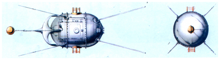
Figure 1External view of the DS-MG type spacecraft (Kosmos-26 and Kosmos-49), 1964 (Konyukhov, 2000).
2.2 Kosmos-321
The success of the first mission with experimental DS-series spacecraft also confirmed the feasibility of remote sensing methods for solving a great variety of scientific problems. The Academy of Sciences of the USSR developed technical specifications for a new series of unified spacecraft that included three standard platforms: DS-U1 (with a chemical energy source), DS-U2 (with solar panels without self-orientation), and DS-U3 (with solar panels and self-orientation). The onboard control and supply systems' segment had standardized construction and was independent from the specific mission payload segment. This allowed the organization of the serial production of spacecraft and their components, reducing financial and time expenditure. The follow-on mission aimed at a global geomagnetic survey of the Earth also consisted of two spacecraft of a new DS-U2-MG type designated Kosmos-321 and Kosmos-356 and launched on 20 January 1970 and 10 August 1970, respectively, from Plesetsk cosmodrome (Arkhangelsk region). The design of both spacecraft was identical: cylindrical body with a diameter of 0.8 m and length of 1.46 m, consisting of a cylindrical shell and two hemispherical bottoms. The spacecraft had three separate compartments for scientific equipment, support systems, and power supply systems.
The mission payload included a self-generated quantum magnetometer with optical pumping in cesium vapor. Cesium has been chosen as the working medium since the frequency change effect of the center of the magnetic resonance line with the field sign change, inherent for alkali metals, has the lowest value for cesium and is about 1–2 nT for this magnetometer. The magnetometer design provided measurements with an arbitrary orientation of the spacecraft. To avoid any possible dead areas, the magnetometer had two absorption chambers oriented at a 135∘ angle to each other. The instrumental accuracy of the magnetometer was estimated at the level of 1.7 nT. The correspondence of the quantum-cesium magnetometer readings to the absolute values in the range of measured fields was verified by comparison with the proton magnetometer. Correspondence was within 2 nT. The magnetometer sensors were placed in a special unpressurized container mounted on a deployable boom of 3.6 m length. The magnetometer was designed and manufactured by IZMIRAN and its experimental design bureau (Dolginov et al., 1970). The external view of the DS-U2-MG spacecraft is given in Fig. 2.
It should be mentioned that during the same period of 1965–1971 the satellites of the POGO series flew, in particular OGO-2, OGO-4, and OGO-6, whose magnetic data are available from NASA (Langel and Hinze, 1998).
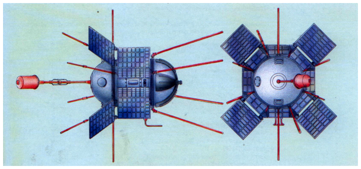
Figure 2External view of the DS-U2-MG spacecraft (Kosmos-321 and Kosmos-356), 1970 (Konyukhov, 2000).
Geomagnetic measurements by the Kosmos-49 satellite were carried out in the framework of the international program of the World Magnetic Survey (Benkova and Dolginov, 1971). The Kosmos-49 mission objectives were as follows: global survey of the Earth's magnetic field and compilation of a map of its spatial distribution; refinement of Gaussian coefficients of magnetic potential decomposition; investigation of the Earth's magnetic field secular variation and temporal changes at the altitudes of the spacecraft flight in the magnetoactive periods. Kosmos-49 operated from 24 October to 3 November, 1964, 11 d in total. It performed 162 orbits around the Earth and made 17 300 measurements covering 75 % of the Earth's surface almost homogeneously. It had an orbit with an inclination of 49∘, nodal period of 91.83 min, apogee of 484 km, and perigee of 265 km. During the mission the apogee decreased from 487 to 472 km approximately linearly in time (see Fig. 4). The accuracy of satellite position was 3 km along the trajectory and 1 km in the transverse direction, and the accuracy of timing was about 0.5 s.
A homogenous survey, performed within a short period of time, provided a general image of the Earth's magnetic field free of secular variations and allowed scientists to map its distribution on the date of the experiment. The collected data were used for obtaining the international analytical model of the Earth's magnetic field. These results were presented and obtained wide scientific recognition at the 7th General Assembly of the ICSU Committee on Space Research (COSPAR) in Florence (Italy) in 1964 (Konyukhov, 2000).
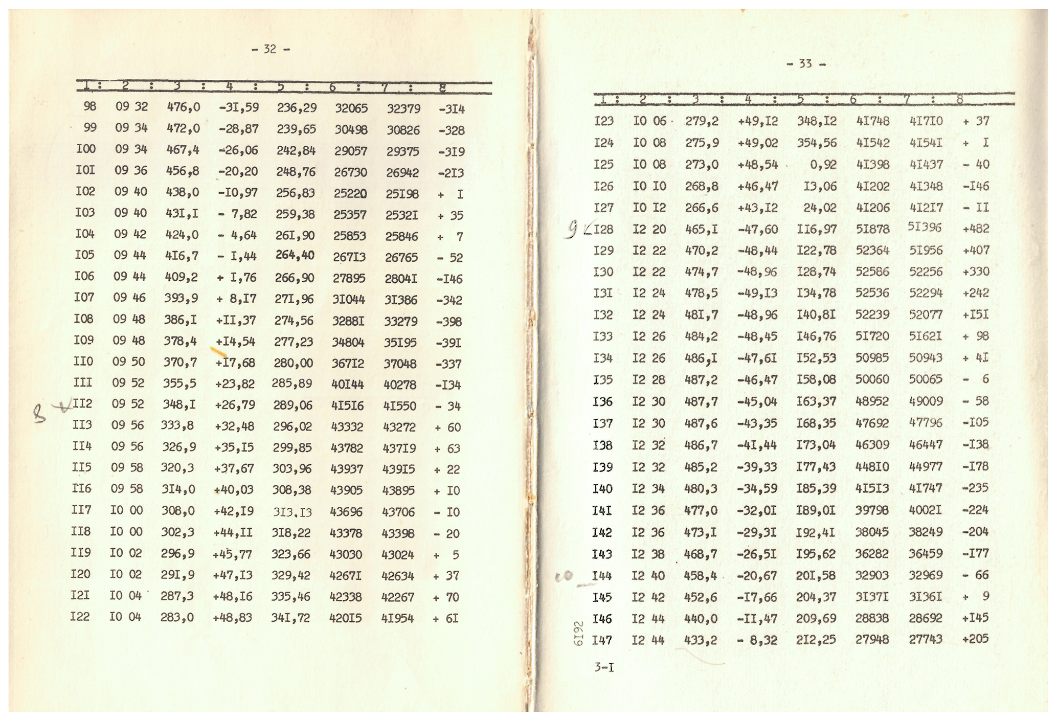
A sample page of the catalog (Dolginov et al., 1967) can be seen in Fig. 3. It contains eight columns with the following data: (1) number of measurement; (2) Moscow time (hours and minutes, rounded to 2 min); (3) altitude, km; (4) latitude (north positive), degrees; (5) longitude (positive, from Greenwich eastward), degrees; (6) measured magnetic field absolute value, nT; (7) magnetic field value calculated according to the global model presented in Adam et al. (1964), nT; (8) the difference between measured and calculated values, nT.
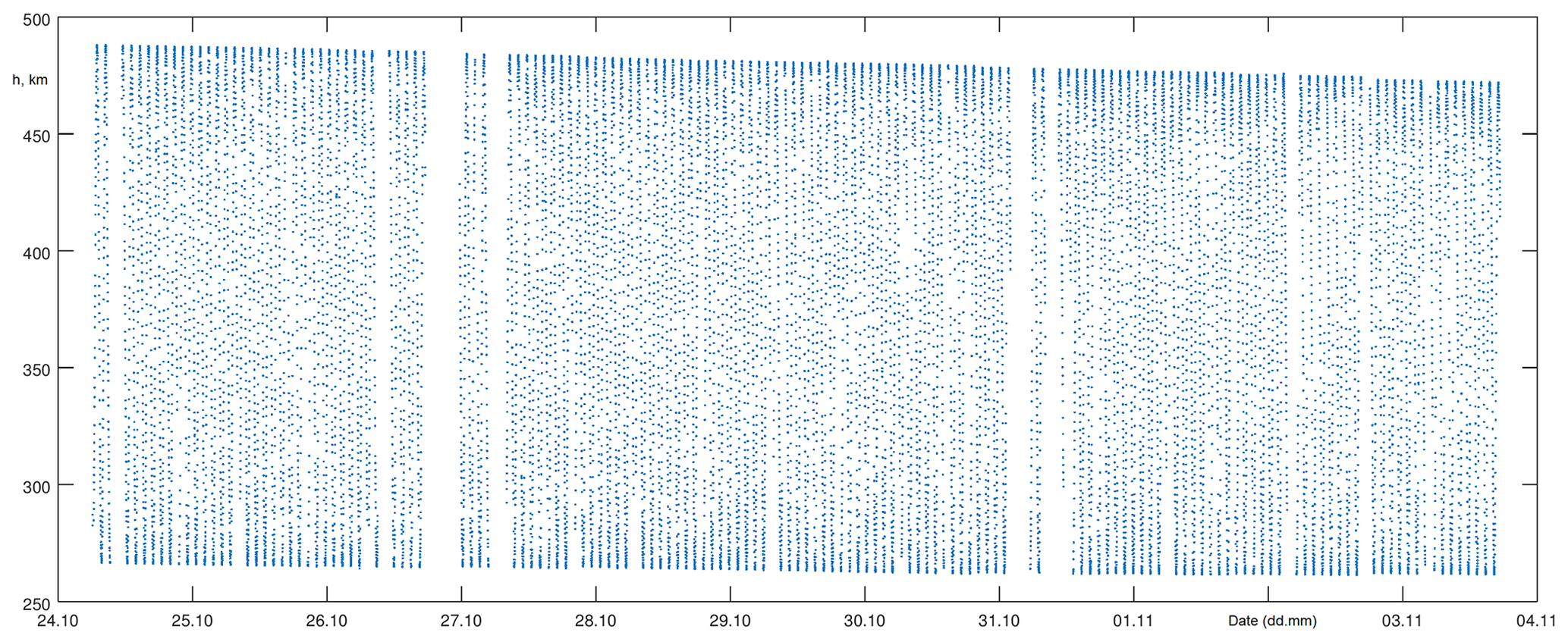
The evolution of Kosmos-49 altitude is shown in Fig. 4. The spatial coverage of data is shown in Fig. 5. The projection of approximately every 20th orbit on the Earth's surface is shown. Dots indicate the locations of measurements. The gaps correspond to areas in which the data were not recorded due to technical failures.
In Figs. 6 and 7 the complete set of satellite positions at the moments of measurements and the map of measured magnetic field absolute value are shown.

Figure 5Spatial coverage of Kosmos-49 data. The projection of approximately every 20th orbit on the Earth's surface is shown. Dots indicate the locations of measurements.
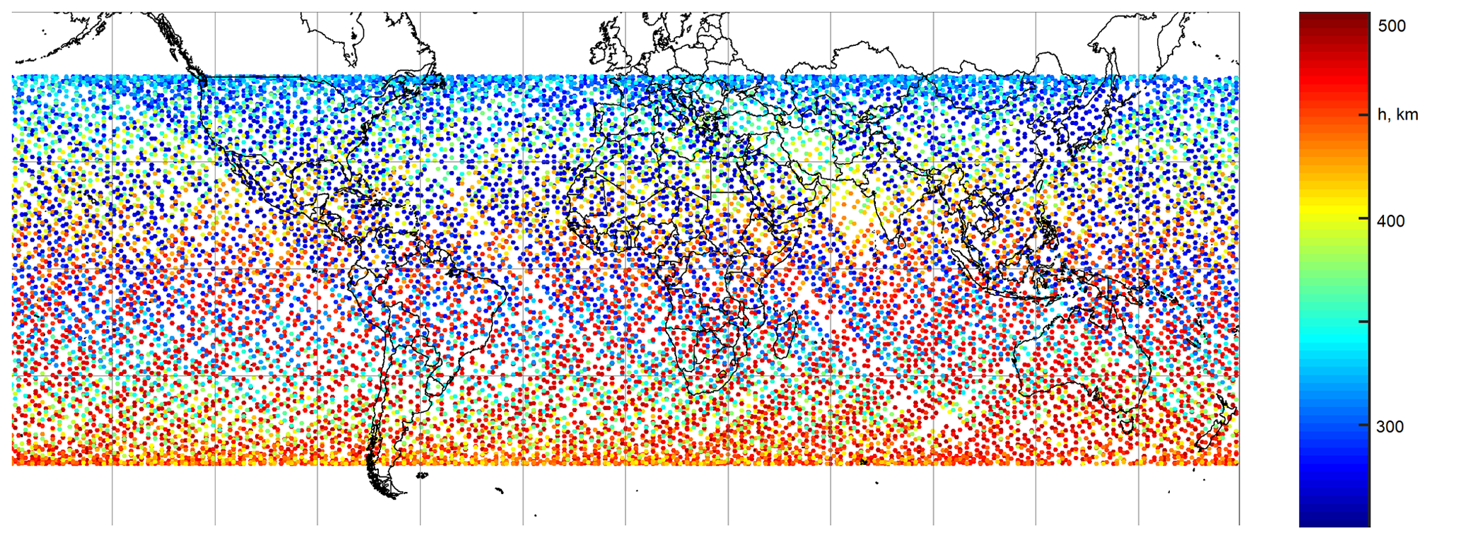
Figure 6Kosmos-49 positions of measurements. Altitude is shown in color.
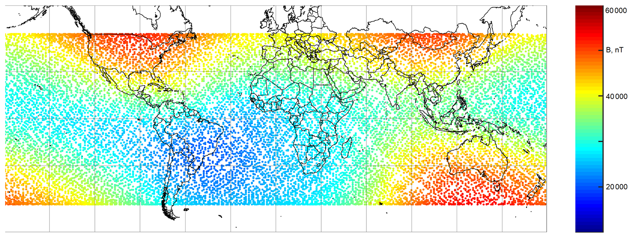
Figure 7Magnetic field map measured by Kosmos-49.
The Kosmos-321 mission main objectives were the same as for Kosmos-49 but also included some specific tasks, such as confirming the possibility of using magnetometers with optical pumping as a service system for nuclear test explosion control in outer space and a series of atmospheric experiments. The mission experimental program was developed by IZMIRAN and the Space Research Institute of the Russian Academy of Sciences. Kosmos-321 operated from 20 January to 13 March 1970, 52 d in total. It performed 823 orbits around the Earth and made over 600 000 measurements covering 94 % of the Earth's surface. It had an orbit with an inclination of 71∘, nodal period of 92 min, apogee of 507 km, and perigee of 280 km. During the mission the apogee decreased from approximately 500 to approximately 300 km. In the available data the apogee runs from 470 to 315 km.
Measurements were performed with 2 s sampling. The primary examination of data showed that they contain strong interference (up to 20 nT) presumably from thermocurrents in the sensor fixing device. (The effect of thermocurrents was reproduced on the fixing device similar to that of Kosmos-321.) This interference manifests as a gap in measured magnetic field absolute values every time the sensor used for measurement was changed (see Fig. 8). For this reason the catalog contains data for only a limited number of orbits, a total of 5000 measurements, for which the interference has approximately sinusoidal form and was eliminated from data upon data processing at IZMIRAN. The “equal squares” method was applied. Both raw data and corrected data are presented in the catalog (Dolginov et al., 1976). It should be noted that the catalog uses 20 s sampling not 2 s sampling used during actual measurements.
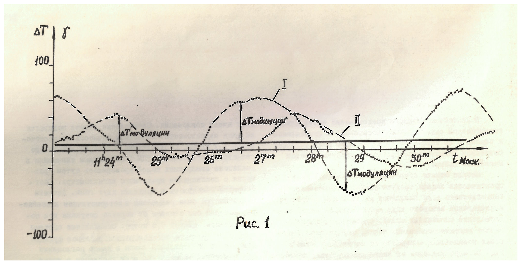
Figure 8Interference in Kosmos-321 data as shown in the catalog (Dolginov et al., 1976). Roman I and II stand for two sensors, actual measurements are indicated with dots, and dashed lines continuously complement the measurements of each sensor.
The sample page of the catalog can be seen in Fig. 9. It contains nine columns with the following data: (1) Moscow time (hours, minutes, and seconds); (2) local time; (3) latitude (north positive), degrees; (4) longitude (positive, from Greenwich eastward), degrees; (5) altitude, km; (6) measured magnetic field absolute value, nT; (7) corrected magnetic field absolute value, nT; (8) the difference between corrected value and the value calculated according to the global model presented in Cain and Sweeney (1970), nT; (9) calculated magnetic inclination, degrees.

The dependence of Kosmos-321 altitude on time is shown in Fig. 10. Spatial coverage of Kosmos-321 data is shown in Fig. 11, and the corrected magnetic field value is shown in Fig. 12.
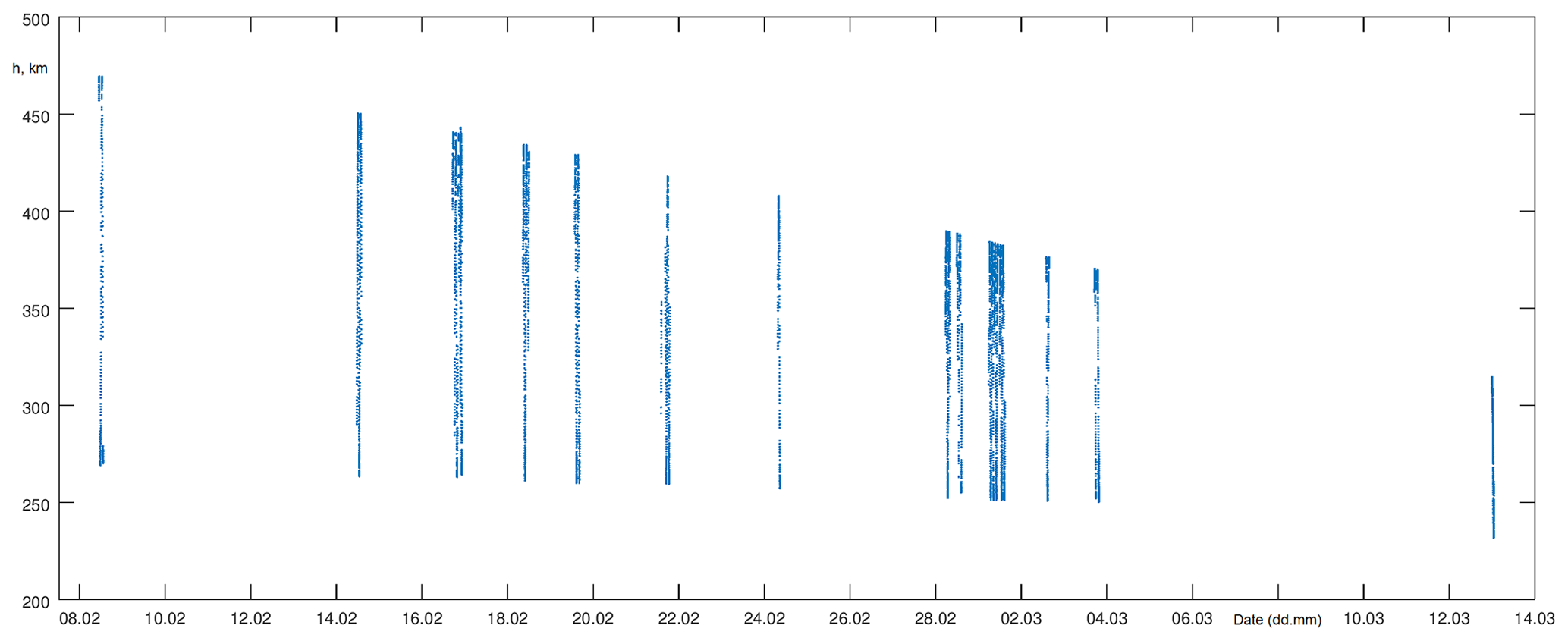

Figure 11Spatial coverage of available Kosmos-321 data.
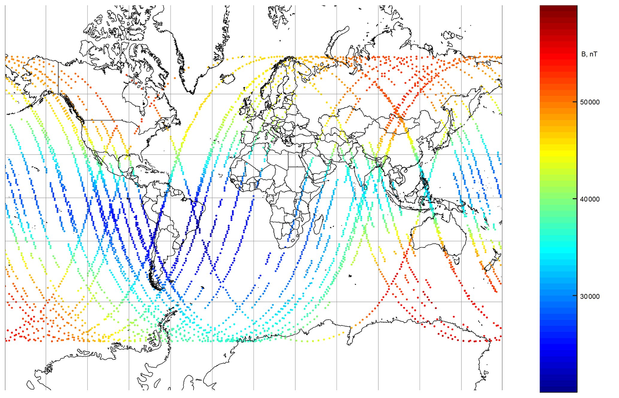
Figure 12Kosmos-321 measured magnetic field.
The Kosmos-49 mission data tables occupied 648 pages (three volumes) (Dolginov et al., 1967), and the Kosmos-321 mission data tables occupied 173 pages (Dolginov et al., 1976). The data were digitized by the Laboratory of Geophysical Data at the Geophysical Center of the Russian Academy of Sciences (RAS) within the three summer months of 2019. For the convenience of users, in the digital version of the catalogs the table structure has been slightly changed as follows.
-
For Kosmos-49 the columns are as follows.
-
Julian day
-
Date/time (Moscow) yyyy-mm-dd T hh:mm
-
Number of measurements
-
Altitude, km
-
Latitude, deg
-
Longitude, deg
-
T measured, nT
-
T calculated, nT
-
ΔT=Tmeas–Tcalc, nT
-
Orbit number
-
-
For Kosmos-321 the columns are as follows.
-
Julian day
-
Date/time (Moscow) yyyy-mm-dd T hh:mm:ss.fff
-
Date/time (local) yyyy-mm-dd T hh:mm:ss.fff
-
Orbit number
-
Latitude, deg
-
Longitude, deg
-
Altitude, km
-
T measured, nT
-
T corrected, nT
-
ΔT=Tcorr–Tcalc, nT
-
Calculated inclination, deg
-
It is obvious that digitization of the data set of such a volume could have led to errors and misprints made by the digitizing personnel. To prevent such a situation all the data arrays were automatically checked after the digitization. This was done by means of specially developed software that for each orbit revolution of the spacecraft controlled the time intervals and allowed the plotting of the graphs for the spacecraft orbital motion and for the measured and calculated geomagnetic data. The consistency, monotony, smoothness, extremal points, etc. of the digitized data were checked. In case of discrepancies within the software calculation results, a manual check with the printed versions of catalogs was carried out. These operations minimized all possible errors of the personnel during digitization. The digitized catalogs are publicly available in ASCII tab-separated text format (Krasnoperov et al., 2020).
The data from the paper catalogs were digitized at Geophysical Center of the RAS in 2019. Digital data are available at PANGAEA (Krasnoperov et al., 2020, https://doi.org/10.1594/PANGAEA.907927).
The success of the satellite missions of the Kosmos-49 and Kosmos-321 spacecraft allowed unique data on the spatial distribution of the total intensity of the Earth's magnetic field over almost the whole surface of the planet to be obtained. These data were a part of the international program of the World Magnetic Survey and were submitted to the main World Data Centers in Moscow (USSR), Maryland (USA), Charlottenlund (Denmark), and Kyoto (Japan) and were used as initial data for analysis of the structure of the Earth's magnetic field sources and for compilation of a series of its analytical models. The most notable model that employed Kosmos-49 data was the first generation of the International Geomagnetic Reference Field (for epoch 1965.0) (Zmuda, 1971). The model was agreed upon by a working group on 24 October 1968 in Washington, DC (USA), approved by a special committee of the International Association of Geomagnetism and Aeronomy in February 1969 and officially introduced at the XVth General Assembly of the International Union of Geodesy and Geophysics in 1971 in Moscow (Blagonravov, 1978).
Comparison of the data collected by the Kosmos-49 and Kosmos-321 spacecraft allowed the determination of the Earth's magnetic field secular variation with high accuracy for the period of 1965–1970. Another important topic was the study of temporal changes in the geomagnetic field at the altitudes of the flight of spacecraft during magnetoactive periods. Kosmos-321 encountered a strong magnetic storm on 8–10 March 1970. As a result, very interesting and important data on the magnetic storm mechanisms in polar regions were obtained. However, the data registered during this period were not included in the publicly available catalog. Only a few footprints of these data may be found in papers (Dolginov et al., 1972). Kosmos-321 measured the effects of the equatorial electrojet for the first time (Vanian et al., 1975). In addition to the traditionally known magnetic storm current systems detected by ground-based magnetic observatory records, magnetic effects of currents along power lines that were not detected by the nearest magnetic observatories were also revealed.
The results of the Kosmos-49 and Kosmos-321 missions became the sound base for further fundamental studies of the Earth's magnetic field from space. The uniqueness of the presented data is emphasized by the fact that there are practically no older and publicly available global satellite data on the Earth's magnetic field.
RK, RL, and AS helped prepare the manuscript. DP provided the description and preliminary analysis of initial data and helped with publication of the digitized catalogs. BD was involved in data digitalization management, data validation, description of digitized data, and preparation of figures.
The authors declare that they have no conflict of interest.
The authors wish to thank the Institute of Terrestrial Magnetism, Ionosphere and Radio Wave Propagation of the RAS and the Space Research Institute of the RAS for compilation of printed versions of the presented catalogs. This work employed data and services provided by the Shared Research Facility “Analytical Geomagnetic Data Center” of the Geophysical Center of the RAS (http://ckp.gcras.ru/, last access: 4 March 2020). The authors wish to thank the team of the World Data Center for Solar-Terrestrial Physics and World Data Center for Solid Earth Physics in Moscow (Russia) for preservation and making publicly available historical geophysical recordings.
This paper was edited by Kirsten Elger and reviewed by Susan Macmillan and one anonymous referee.
This work was conducted in the framework of budgetary funding of the Geophysical Center of RAS, adopted by the Ministry of Science and Higher Education of the Russian Federation.
Adam, N. V., Osipov, N. K., Tyurmina, L. O., and Shlyakhtina, A. P.: Spherical harmonic analysis of world magnetic charts for the 1960 epoch, Geomagn. Aero., 4, 878–879, 1964.
Benkova, N. P. and Dolginov, Sh. Sh.: The survey with Cosmos-49, IAGA Bull., 28, 75–78, 1971.
Blagonravov, A. A. (Ed.): Space exploration progress in the USSR: Second space decade, 1967–1977, Nauka Publishers, Moscow, USSR, 1978 (in Russian).
Cain, J. C.: Geomagnetic Models from Satellite Surveys, Rev. Geophys., 9, 259–273, 1971.
Cain, J. C. and Sweeney, R. E.: Magnetic field mapping of the inner magnetosphere, J. Geophys. Res., 75, 4360–4362, https://doi.org/10.1029/JA075i022p04360, 1970.
Dolginov, Sh. Sh., Kozlov, A. N., and Chinchevoi, M. M.: Magnetometers for space measurements, Rev. Phys. Appl., 5, 178–182, https://doi.org/10.1051/rphysap:0197000501017800, 1970.
Dolginov, Sh. Sh., Kozlov, A. N., Kolesova, V. I., Kosacheva, V. P., Nalivaiko, V. I., Strunnikova, L. V., Tyurmin, A. V., Tyurmina, L. O., Fastovsky, U. V., Cherevko, T. N., Aleksashin, E. P., Velchinskaya, A. S., Gavrilova, E. A., Pokras, V. I., Sinitsyn, V. I., and Yagovkin, A. P.: Catalogue of measured and computed values of the geomagnetic field intensity along the orbit of the Kosmos-321 satellite, Nauka Publishers, Moscow, USSR, 1976 (in Russian).
Dolginov, Sh. Sh., Nalivayko, V. I., Tyurmin, A. V., and Chinchevoy, M. M.: Experiments under the program of the world magnetic survey, in: “Space Research”, Transactions of the All-Union Conference on Space Physics, Moscow, USSR 10–16 June 1965 (translation of “Issledovaniya Kosmicheskogo Prostranstva”, Trudy Vsesoyuznoy Konferentsii po Fizike Kosmicheskogo Prostranstva. Izdatel'stvo “Nauka”, 1965), NASA, Washington D.C., USA, 806–816, 1966.
Dolginov, Sh. Sh., Nalivayko, V. I., Tyurmin, A. V., Chinchevoy, M. M., Brodskaya, R. E., Zlotin, G. N., Kiknadze, I. N., and Tyurmina, L. O.: Catalogue of measured and computed values of the geomagnetic field intensity along the orbit of the Kosmos-49 satellite, Academy of Sciences USSR IZMIRAN, Moscow, USSR, 1967 (in Russian).
Dolginov, Sh. Sh., Zhigalov, L. N., Strunnikova, L. V., Fel'dshteyn, Ya. I., Cherevko, T. N., and Sharova, V. A.: Magnetic storm of March 8–10, 1970, According to ground-based and Kosmos-321 observations, Geomagn. Aeronomy, 12, 909–918, 1972.
Konyukhov, S. N. (Ed.): Rockets and spacecraft of Yuzhnoye Design Office (in Russian), OOO “ColorGraph” and OOO “Tandem-U”, Dnepropetrovsk, Ukraine, 2000.
Krasnoperov, R., Peregoudov, D., Lukianova, R., Soloviev, A., and Dzeboev, B.: Early soviet satellite magnetic field measurements from 1964 and 1970, PANGAEA, https://doi.org/10.1594/PANGAEA.907927, 2020.
Langel, R. A. and Hinze, W. J.: The magnetic field of the Earth's lithosphere: the satellite perspective, Cambridge University Press, Cambridge, United Kingdom, New-York, USA, Melbourne, Australia, 1998.
Petrukovich, A. A., Mulyarchik, T. M., Vasyutkov, S. V., Verigin, M. I., Kotova, G. A., and Styazhkin, V. A.: The first Soviet space experiments in 1957–1959: history and results, History Earth Sci., 2, 5–24, 2009 (in Russian).
Skuridin, G. A. (Ed.): Mastery of outer space in the USSR, 1957–1967 (translation of “Osvoyeniye kosmicheskogo Prostranstva v SSSR, 1957–1967”, Moscow, “Nauka” Press, 1971), NASA, Washington D.C., USA, 1975.
Vanian, L. L., Fainberg, E. B., and Genis, N. E.: Deep sounding of the Earth by ground-based and satellite measurements of the magnetic field of the equatorial electrojet, Geomagn. Aero., 15, 112–116, 1975.
Zmuda, A. J.: The International Geomagnetic Reference Field 1965.0: Introduction, IAGA Bull., 28, 148–152, 1971.