the Creative Commons Attribution 4.0 License.
the Creative Commons Attribution 4.0 License.
 | 22 Jul 2025
Development of Level 2 aerosol and surface products from cross-track scanning polarimeter POSP on board the GF-5(02) satellite
Cheng Chen
Xuefeng Lei
Zhenhai Liu
Haorang Gu
Oleg Dubovik
Pavel Litvinov
David Fuertes
Yujia Cao
Haixiao Yu
Guangfeng Xiang
Binghuan Meng
Zhenwei Qiu
Xiaobing Sun
Jin Hong
Zhengqiang Li
The development of long-term, continuous, consistent, and high-quality satellite remote sensing aerosol and surface products is crucial to constrain climate models and improve our understanding of climate change. Particulate Observing Scanning Polarization (POSP) is the first space-borne multi-spectral (UV–VIS–NIR–SWIR) cross-track scanning polarimeter dedicated to complementing the Directional Polarimetric Camera (DPC) multi-angle polarimetric measurements and performing synergistic observations, namely the polarization crossfire (PCF) suite on board the Chinese GF-5(02) (Gaofen-5 series) satellite. The POSP's unique single-view spectral (UV–VIS–NIR–SWIR) high-precision polarimetric measurements provide rich information for atmospheric aerosol and surface characterization. Here, we developed aerosol and surface products from POSP/GF-5(02) based on the Generalized Retrieval of Atmosphere and Surface Properties (GRASP)/Models approach. The detailed retrieval approach and processing scheme are provided. The baseline Level 2 product was generated for the first 18 months of POSP measurements from December 2021 to May 2023 and is publicly available and registered at https://doi.org/10.57760/sciencedb.14748 (Chen et al., 2024c). The obtained POSP/GF-5(02) aerosol and surface products are validated and intercompared with the ground-based AERONET reference aerosol dataset and other independent satellite products, such as the NOAA-20 VIIRS/DB aerosol product and the MODIS MCD43 surface product. The results show generally good consistency of POSP products with AERONET, the VIIRS/NOAA-20 aerosol dataset, and the MODIS surface product. Moreover, the developed POSP product includes not only total aerosol optical depth (AOD) but also detailed properties of aerosols (aerosol size, absorption, layer height, type, etc.), along with full-surface bidirectional reflectance distribution function (BRDF), bidirectional polarization distribution function (BPDF), black-sky albedo, white-sky albedo, and normalized difference vegetation index (NDVI). These parameters are of high importance to constrain the Earth–atmosphere radiation budget. The retrieval of these properties seems to be possible due to the polarimetric capabilities and wide UV–VIS–NIR–SWIR spectral range of POSP observations and advances of the used GRASP/Models retrieval approach. Finally, some potential improvements for the POSP Level 1–Level 2 processing chain are identified, and the limitations and lessons learned are discussed.
- Article
(16761 KB) - Full-text XML
- BibTeX
- EndNote


Satellite remote sensing provides an important source of data for dealing with climate change challenges and monitoring environmental health. Therefore, the accumulation of high-quality, long-term, consistent remote sensing observational data has received more and more attention. Especially for climate change studies, the establishment of long-term and high-precision satellite remote sensing products, despite huge challenges, is particularly important for reducing the uncertainty of climate change assessments (IPCC, 2021). Space agencies and even private companies are launching or planning to launch an increasing number of Earth-observing sensors. In particular, polarimetric remote sensing is widely regarded as one of the best technologies for detecting atmospheric aerosols and clouds (Dubovik et al., 2019, 2021b; Hansen et al., 1997; Mishchenko et al., 2004). The deployment of the first multi-angle polarimeter (MAP) payload, Polarization and Directionality of the Earth's Reflectances (POLDER) series (POLDER-1, POLDER-2, and POLDER-3) (Bréon et al., 2011; Deschamps et al., 1994; Tanré et al., 2011) developed by the French national space agency (CNES), was followed by HARP-2 (Hyper-Angular Rainbow Polarimeter) and SPEXOne (Spectro-Polarimetric Experiment) recently launched on NASA's PACE (Plankton, Aerosol, Cloud, ocean Ecosystem) mission (Hasekamp et al., 2019; Martins et al., 2018; Remer et al., 2019a, b). In addition, the first commercial multi-angle CubeSat polarimeter of the GAPMAP series has been launched by GRASP-Earth (Fuertes et al., 2023; Martins et al., 2024). The information content richness of multi-angle polarimetric data is evident and demonstrated in numerous applications (Cairns et al., 2009; Chen et al., 2020, 2022a; Dubovik et al., 2011, 2019; Fu et al., 2020; Fu and Hasekamp, 2018; Gao et al., 2019; Hasekamp et al., 2024, 2011; Knobelspiesse et al., 2020; Waquet et al., 2009; Xu et al., 2016, 2017a, b). At the same time, the community also recognizes the challenges in extracting the large number of parameters from polarimetric observations (Dubovik et al., 2019; Chen et al., 2020). Therefore, in order to leverage the information richness of multi-angle polarimetric measurements on a global scale, releasing different levels of products and sharing the successes and challenges with the broader community are crucial.
China has recently launched several payloads with polarimetric capabilities. Most of these sensors were designed and developed by the Anhui Institute of Optics and Fine Mechanics (AIOFM), Chinese Academy of Sciences (CAS) (Chen et al., 2021b; Li et al., 2018, 2022b, c, d). However, past efforts focused on the development of instruments, while the development of user-end products and in-depth product analysis was lacking. For example, the Directional Polarimetric Camera (DPC), which is the first POLDER-like Chinese operational MAP sensor, was launched on board the GaoFen-5 (GF-5) satellite in 2018 (Li et al., 2018), and several similar instruments have been deployed on different platforms afterward. There are several case studies (regional or short term) that use the data to determine aerosol and cloud properties that have been published (Cao et al., 2025; Chen et al., 2021a; Ge et al., 2022; Jin et al., 2022; Lei et al., 2023; Li et al., 2021, 2022a; Shang et al., 2020; Wang et al., 2022; Yu et al., 2024; Zhang et al., 2023); however, reliable information about the released global product and demonstration of its use for environmental and climate applications is limited.
In this study, we focus on the development of global aerosol and surface products from a new polarimeter (POSP), the first space-borne UV–VIS–NIR–SWIR multi-spectral cross-track scanning polarimeter on board the GF-5(02) satellite. POSP was designed to complement DPC multi-angle polarimetric measurements of I, Q, and U at VIS–NIR channels conducted on the same platform with a maximum of 17 viewing angles and ∼3.3 km spatial resolution. POSP extends to include UV and SWIR channels, which are expected to enhance atmospheric aerosol detection capability, particularly for aerosol layer height and fine-/coarse mode, to achieve the main goal of the GF-5(02) mission, which is dedicated to PM2.5 remote sensing (Li et al., 2022d). Meanwhile, due to the onboard calibration device for POSP, it was expected to obtain higher accuracy of intensity/polarization measurements than DPC, which could perform cross-calibration between DPC and POSP (Lei et al., 2023). Therefore, the cross-track pattern was chosen to achieve more overlaps. The GRASP/Models approach, which has previously been successfully applied to the multi-angle polarimeter (Chen, et al., 2020; Dubovik et al., 2021b, etc.) and multi-spectral spectrometer (UV–VIS–NIR–SWIR) (e.g. Litvinov et al., 2024; Chen et al., 2024a) is adapted to process POSP single-viewing UV–VIS–NIR–SWIR polarimeter measurements. In the previous development of TROPOMI/Sentinel-5p aerosol and surface products within the framework of the ESA S5p + Innovation AOD/BRDF project (Litvinov et al., 2022), we demonstrate the possibility of extending aerosol and surface characterization from single-view UV–VIS–NIR–SWIR measurements with properly constrained forward models and advanced retrieval algorithms (Litvinov et al., 2024; Chen et al., 2024a). We describe the POSP/GF-5(02) Level 1 measurements and global aerosol/surface datasets used in this study in Sect. 2. Section 3 describes the POSP aerosol and surface retrieval scheme and the Level 2 product specification. Section 4 illustrates the preliminary validation and evaluation of the POSP Level 2 aerosol and surface product. The study is concluded in Sect. 5 with a summary and discussion of the lessons learned.
In this section, the POSP/GF-5(02) satellite level measurements and the independent ground-based and space-borne aerosol and surface datasets used in this study are described.
2.1 Single-view scanning polarimeter POSP/GF-5(02) Level 1 data
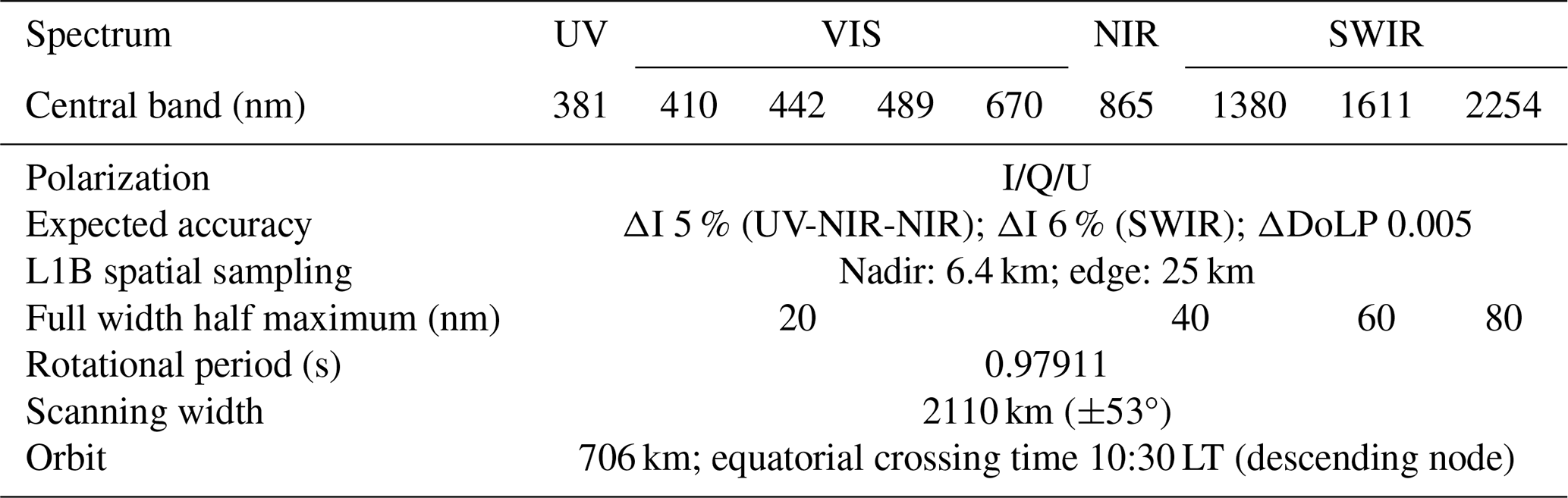
Gaofen (GF) is a series of Chinese civilian remote sensing satellites specifically for China's high-resolution Earth observation system (Chen et al., 2022c; Gu and Tong, 2015; Tong et al., 2016). Among them, the GF-5 satellite is designed and dedicated to atmospheric detection and environmental monitoring, including aerosol, cloud, water vapor, ozone, and tracer gases. The first GF-5(01) satellite was launched on 8 May 2018. GF-5(01) carries six payloads: specifically, the DPC, Environment Monitoring Instrument (EMI), Greenhouse Gases Monitoring (GMI), Atmospheric Infrared Ultra-spectral Sensor (AIUS), Visual Infrared Multi-spectral Sensor (VIMS), and Advanced Hyperspectral Imager (AHSI). The GF-5(01) satellite continued working until March 2021. Subsequently, the second GF-5(02) satellite was launched on 7 September 2021. Generally, GF-5(02) maintains a similar design to GF-5(01). In order to enhance the atmospheric detection capability, GF-5(02) deployed a new POSP instrument, which is a cross-track scanning polarimeter, to complement DPC and perform synergistic observations, namely the polarization crossfire suite (Li et al., 2022d). The original POSP design idea came from the NASA Aerosol Polarimetry Sensor (APS), which was an along-track scanning polarimeter and was lost during the unsuccessful launch of the Glory mission in 2011 (Dubovik et al., 2019; Mishchenko et al., 2007). POSP is the first space-borne multi-spectral cross-track scanning polarimeter, covering the UV–VIS–NIR–SWIR wavelengths (Lei et al., 2020). Specifically, an onboard calibration device is designed for POSP to perform on-orbit solar diffuse reflector-based radiometric calibration and polarimetric calibration. Hence, it is expected to obtain high-precision polarimetric measurements from POSP, achieving cross-calibration between DPC and POSP (Lei et al., 2023). Table 1 summarizes the POSP/GF-5(02) main sensor characteristics and spectral channels used in this study.
Table 1Instrument characteristics for POSP on board the GF-5(02) satellite.
Our development of the Level 2 aerosol and surface processing starts from the POSP Level 1B top-of-atmosphere (TOA) measurements. Before re-gridding Level 1B onto Level 1C 10 km × 10 km grid, we use three consecutive steps to filter Level 1B data for aerosol and surface retrieval. Figure 1 shows the schematic diagram illustrating the POSP data preprocessing from Level 1B to Level 1C for aerosol and surface retrieval.
-
Step 1. Skip left and right 10 pixels at the edges of each swath.The spatial resolution of the POSP Level 1B pixel is approximately 6.4 km at nadir, and the spatial sampling size becomes larger as the scan gets closer to the edge of the track (Fig. 1). The POSP field of view is ±53° and the orbit height is at ∼706 km; therefore, the pixel size at the edge is approximately 25 km. According to the recommendation from the Level 1 data team, we simply skip 10 pixels at the edges of each swath and proceed with 10 km Level 2 aerosol and surface retrieval.
-
Step 2. Although the delivered POSP Level 1B data comes with cloud identification, it exhibits evident misclassifications, and its overall performance remains limited. We apply three additional conditions to filter cloudy pixels based on simple threshold methods. Specifically, TOA reflectance R (1380 nm) < 0.02 is used to filter possible cirrus clouds. Then, the MODIS spatial variability method (3×3 window standard deviation) is used (Martins et al., 2002), and the threshold is slightly adjusted for POSP. We use 3×3_SD_R (412 nm) < 0.03 over land, and 3×3_SD_R (865 nm) < 0.03 over ocean. In addition, we use a one-pixel buffer zone for possible cloud shadows. Any pixel next to an identified cloudy pixel is removed for aerosol and surface retrieval. Overall, there is a significant potential for improving cloud identification for POSP Level 1B data generation, especially since the polarimetric measurements are not used at the moment. The snow/ice mask is not used in this study, and some snow/ice pixels may be removed in the cloud procedure. However, others may affect our Level 2 aerosol and surface retrieval.
-
Step 3. The ocean sun-glint mask is achieved by applying a threshold on the glint angle (θg) using solar and view zenith angles (θs and θv) and their relative azimuth angle (Δϕ) (see Eq. 1) (Cox and Munk, 1954). A small glint angle indicates higher probabilities of sun glint. In this study, each ocean pixel with a glint angle smaller than 40° is filtered:
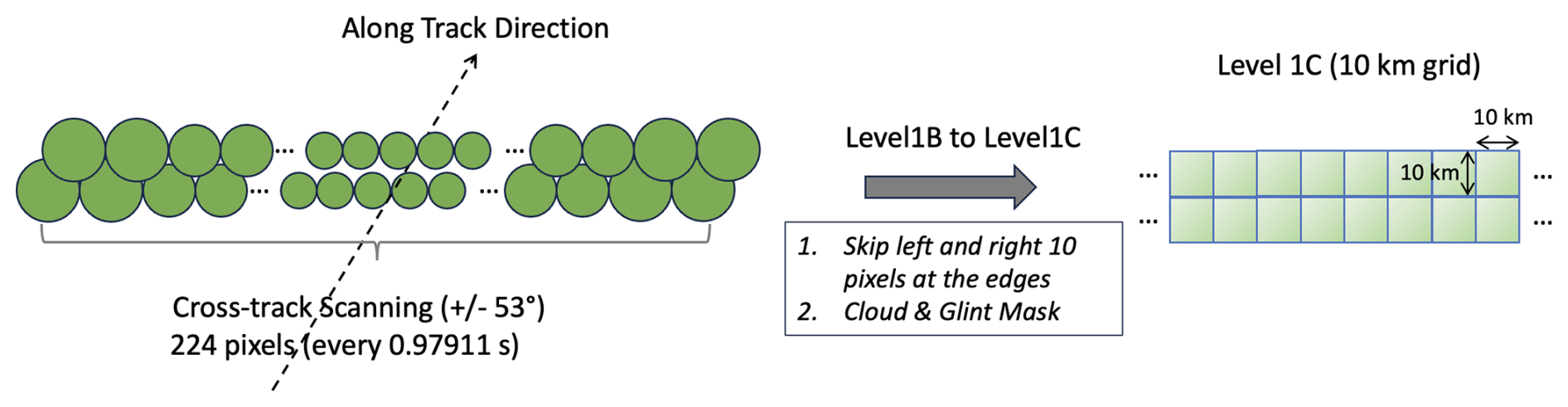
Figure 2 shows an example of POSP TOA Level 1B measurements on 28 February 2022 (Fig. 2a) and its corresponding Level 1C preprocessed for aerosol and surface retrieval (Fig. 2b). The TOA false color RGB image is composed of POSP reflectance from 670, 489, and 410 nm channels, respectively.
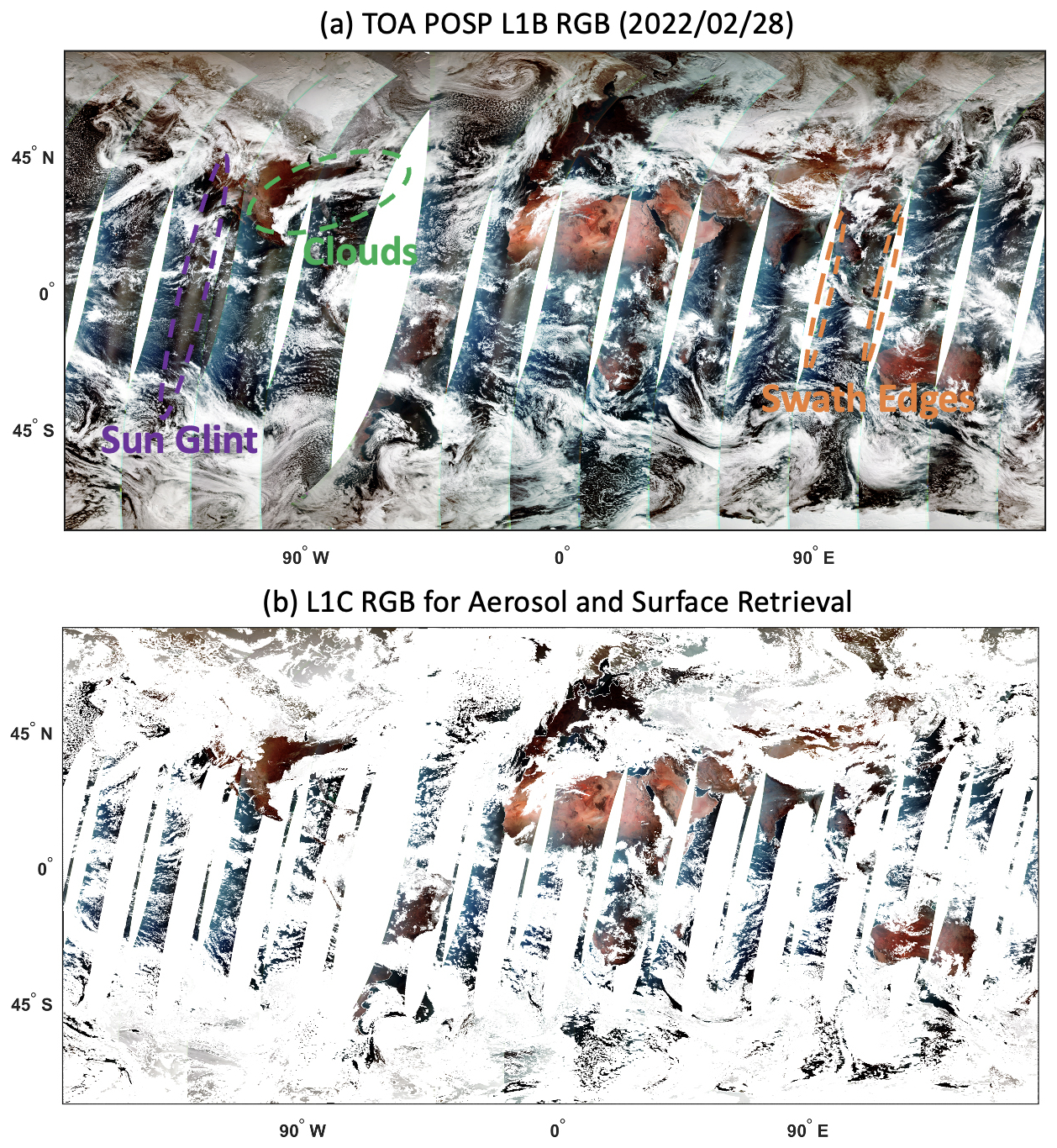
Figure 2An example of POSP TOA measurements on 28 February 2022 illustrating (a) Level 1B TOA false color RGB and (b) preprocessed Level 1C data prepared for aerosol and surface retrieval.
2.2 Datasets used for validation and evaluation
2.2.1 Ground-based AERONET aerosol reference dataset
In order to validate the retrieval of aerosol optical–microphysical properties, the ground-based Aerosol Robotic Network (AERONET) aerosol reference dataset is used (Holben et al., 1998). AERONET direct sun multi-spectral aerosol optical depth (AOD), Ångström exponent (AE), spectral deconvolution algorithm (SDA), fine-mode AOD (AODF), coarse-mode AOD (AODC) (O'Neill et al., 2003), and single-scattering albedo (SSA) from inversion products based on the almucantar measurements (Dubovik et al., 2000; Dubovik and King, 2000; Dubovik et al., 2000, 2002, 2006) are used to validate POSP aerosol retrievals. Specifically, we use the up-to-date AERONET Version 3 Level 2 products (https://aeronet.gsfc.nasa.gov/, last access: 19 February 2024) (Giles et al., 2019; Sinyuk et al., 2020; Smirnov et al., 2000) and make use of all AERONET sites with available data during the study period.
2.2.2 Space-borne aerosol and surface datasets from VIIRS and MODIS
Space-borne aerosol and surface datasets obtained from NOAA's Visible Infrared Imaging Radiometer Suite (VIIRS) aboard the NOAA-20 satellite and NASA's Moderate Resolution Imaging Spectroradiometer (MODIS) aboard the TERRA and AQUA satellites are used in this study to compare with the derived POSP aerosol and surface products. Specifically, the NOAA-20 VIIRS Deep Blue (DB) 6 km Version 2.0 Level 2 aerosol product AERDB_L2_VIIRS_NOAA-20 is used to intercompare with the POSP aerosol product (Lee et al., 2024). The AERDB_L2_VIIRS_NOAA-20 dataset includes spectral AOD at 412, 490, 550, and 670 nm over land and AOD at 490, 550, and 670 nm over ocean. The fine-mode fraction at 550 nm is also provided over the ocean, which can be used to derive AODF and AODC at 550 nm (Hsu et al., 2019; Sayer et al., 2018a, b). For surface properties, the MODIS Collection 6.1 Albedo Model Parameters produced at 0.05° (degree) climate model grid datasets (MCD43C3) are used in the intercomparison, including MCD43C3 surface albedos (white-sky albedo and black-sky albedo) at Band 1 (620–670 nm), Band 2 (841–876 nm), Band 3 (459–479 nm), and Band 7 (2105–2155 nm) (Schaaf and Wang, 2015).
3.1 POSP/GF-5(02) Level 2 aerosol and surface retrieval scheme
The GRASP/Models approach is used to retrieve aerosol and surface properties from POSP/GF-5(02) measurements. On top of the GRASP platform, several aerosol modeling approaches have been developed by assuming different parameterization schemes for size distribution, complex refractive index, and chemical composition (Dubovik et al., 2011, 2021a; Li et al., 2019; Chen et al., 2020). Among them, the “Models” approach is one of the most simplified approaches with six spectrally independent parameters to represent aerosol optical–microphysical properties. The GRASP/Models approach has been proven to be efficient in retrieving high-quality aerosol properties from different types of satellite remote sensing measurements, including multi-angle polarimeter, and multi-spectral/hyperspectral spectrometer (Chen et al., 2020, 2022b, 2024a, b; Jin et al., 2022; Litvinov et al., 2024).
Specifically, aerosol total single-scattering characteristics are assumed to be a linear combination of the scattering characteristics of several pre-defined aerosol models (Eq. 2):
where λ indicates the spectral channel, Θ is the scattering angle, ω is the aerosol single-scattering albedo (SSA), P denotes the phase matrix, k denotes one of n aerosol models, Cext denotes the total aerosol extinction, and ck denotes the relative fraction for the kth aerosol model. Following previous applications on OLCI/Sentinel-3 and TROPOMI/Sentinel-5p (Chen et al., 2022b, 2024a; Litvinov et al., 2024), we use a four-model (n=4) approach to process POSP/GF-5(02): k=1 is fine absorbing (biomass burning), k=2 is fine slightly absorbing (urban/sulfate aerosol), k=3 is coarse maritime (sea salt), and k=4 is coarse dust. The definition of the four models' size distribution, spectral complex refractive index, and non-sphericity is based on the AERONET climatology (Dubovik et al., 2002; Lopatin et al., 2021).
In addition, taking into account the limited information from passive remote sensing measurements, aerosol microphysical properties are assumed to be identical at different vertical layers and only the total aerosol volume concentration and the aerosol total extinction profile () vary following the exponential function.
where z represents atmospheric vertical level and h is the aerosol layer height, namely scale height.
The sum of the semi-empirical Ross–Li sparse Bidirectional Reflectance Function (BRF) model (Li and Strahler, 1992; Roujean et al., 1992; Wanner et al., 1995) and the polarized reflection matrix Rp based on semi-empirical Maignan–Bréon BPDF (bidirectional polarization distribution function) models (Litvinov et al., 2010, 2011a, b; Maignan et al., 2009) are used to model surface reflectance for POSP/GF-5(02) processing. The kernel-driven Ross–Li BRDF model uses a linear combination of three kernels fiso, fvol, and fgeom representing isotropic, volumetric, and geometric optics surface scattering, respectively (Li and Strahler, 1992; Roujean et al., 1992; Wanner et al., 1995). In addition, according to Litvinov et al. (2010, 2011a, b), this model is further re-normalized to the spectral invariant of the second (avol) and third (ageom) BRDF parameters in comparison to the first one aiso(λ). In GRASP, the polarized reflection matrix Rp is based on the semi-empirical Maignan–Bréon BPDF model (Maignan et al., 2009). For POSP/GF-5(02) processing, the wavelength-independent scaling parameter (α) for the Fresnel-based reflection matrix is retrieved.
The ocean surface reflectance is modeled as a combination of different ocean surface approaches. Fresnel's reflection from the sea surface is taken into account using the Cox–Munk model (Cox and Munk, 1954). The water leaving radiance is assumed to be isotropic and is taken into account by Lambertian unpolarized reflectance (Voss et al., 2007). The relations between whitecaps/foam fraction and wind speed are defined by the empirical formula by Monahan and O'Muircheartaigh (1980). The spectral dependence of foam is accounted for with the model described in Frouin et al. (1996) and Frouin and Pelletier (2015). The detailed description of the ocean surface reflectance modeling approach used in the GRASP algorithm can be found in Litvinov et al. (2024) and Chen et al. (2022b). The spectrally dependent isotropic water-leaving radiance r0(λ), Fresnel reflection fraction (free from foam, dense sediments, whitecaps, etc.) δFr and the mean square facet slope σ2 are the directly retrieved parameters for the ocean surface.
Then the state vector of each land and ocean pixel for POSP/GF-5(02) processing with the GRASP/Models approach can be represented as follows:
where cv is the columnar aerosol volume concentration, c1 … 4 is the volume fraction of the four different aerosol models, and h is the aerosol scale height. aiso(λ) is the linear coefficient of the Ross–Li BRDF spectral dependent isotropic kernel, and avol and ageom are the linear coefficients of the spectral invariant volumetric and geometric terms. α is the Maignan–Bréon BPDF model spectrally independent scaling parameter for the Fresnel-based reflection matrix. r0(λ) is the spectral dependent isotropic water leaving reflectance, δFr is the fraction of the surface that provides Fresnel reflection (free from foam, dense sediments, whitecaps, etc.), and σ2 is the mean square facet slope.
The inhomogeneous POSP 10 km pixels partially covered by water are skipped for processing. Based on the directly retrieved parameters in the state vector, aerosol optical–microphysical properties and surface properties, such as AOD, AODF, AODC, AAOD, SSA, NDVI, BRDF, BPDF, and different surface albedos (white-sky albedo and black-sky albedo) at UV, VIS, NIR, and SWIR wavelengths, can be calculated and delivered as a product.
The GRASP numerical inversion is implemented as a statistically optimized fitting of the observations using the least-squares multi-term principle (Dubovik et al., 2021a). GRASP implements a multi-pixel technique to improve retrieval by simultaneously inverting a large group of pixels (Dubovik et al., 2011, 2014). This approach allows for significant enhancement of atmosphere properties retrievals from remote sensing measurements by means of using additional a priori information about “correlation” retrieved properties in different pixels of the inverted group. The smallest processing group (segment) in the POSP/GRASP scheme is a group of pixels, where NT is the number of measurements available in a month.
3.2 POSP/GF-5(02) Level 2 aerosol and surface products specification
The primary POSP/GF-5(02) aerosol product is the spectral AOD, which measures the column amount of aerosols in the atmosphere and is widely used in the community. POSP/GRASP Level 2 product offers spectral AOD at nine wavelengths ranging from UV to SWIR. The product includes several additional aerosol characteristics such as AE, spectral fine-/coarse-mode AOD, spectral SSA, and aerosol scale height. These specific aerosol characteristics are connected to aerosol particle size and absorption properties, which are important criteria for the aerosol climate and air quality community. The POSP/GRASP also offers full-surface BRDF and BPDF characteristics, surface NDVI, spectral directional hemispherical reflectance (DHR or black-sky albedo), and spectral surface isotropic bihemispherical reflectance (BHRISO or white-sky albedo). The POSP/GF-5(02) Level 2 aerosol and surface products are contained in a file typically named as GF5B_OSP_L2_Land_Ocean_{YYYYMMDD}.nc. The product fields contained in the NetCDF-4 product file are listed in Table 2.
Table 2List of fields in the POSP/GF-5(02) Level 2 aerosol and surface product.
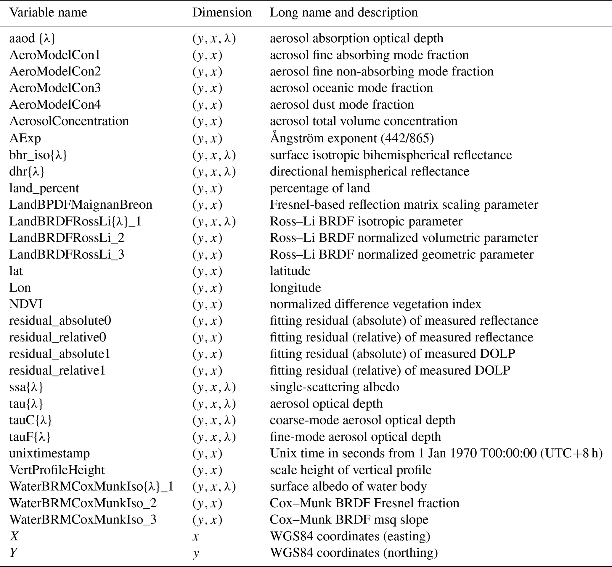
λ=381, 410, 442, 489, 670, 865, 1611, 2254 nm.
4.1 Global distribution of POSP/GF-5(02) Level 2 aerosol and surface product
Based on the method proposed in Sect. 3, we process the first 18 months of POSP/GF-5(02) measurements from December 2021 to May 2023 using four Intel 4-core I9-13900 Think stations. Figure 3 shows the spatial distribution of valid retrievals from December 2021 to May 2023. In summary, approximately 113 million pixels are retrieved successfully, accounting for 70 million of them over land pixels (∼62 %) and 43 million ocean pixels (∼38 %). Evidently, the ocean pixel percentage is much lower than expected, which can be associated with too strict a cloud mask and glint mask used over the ocean. This needs to be adjusted and tested for future processing. We estimate the retrieval speed in order to constrain computational costs for future operational processing based on the 18-month processing effort. Approximately, for land pixels, the mean speed is 0.32 s per pixel per core with 1σ=0.12 s.e. per pixel per core; for ocean pixels, the mean speed is 0.38 s per pixel per core with 1σ=0.13 s per pixel per core.
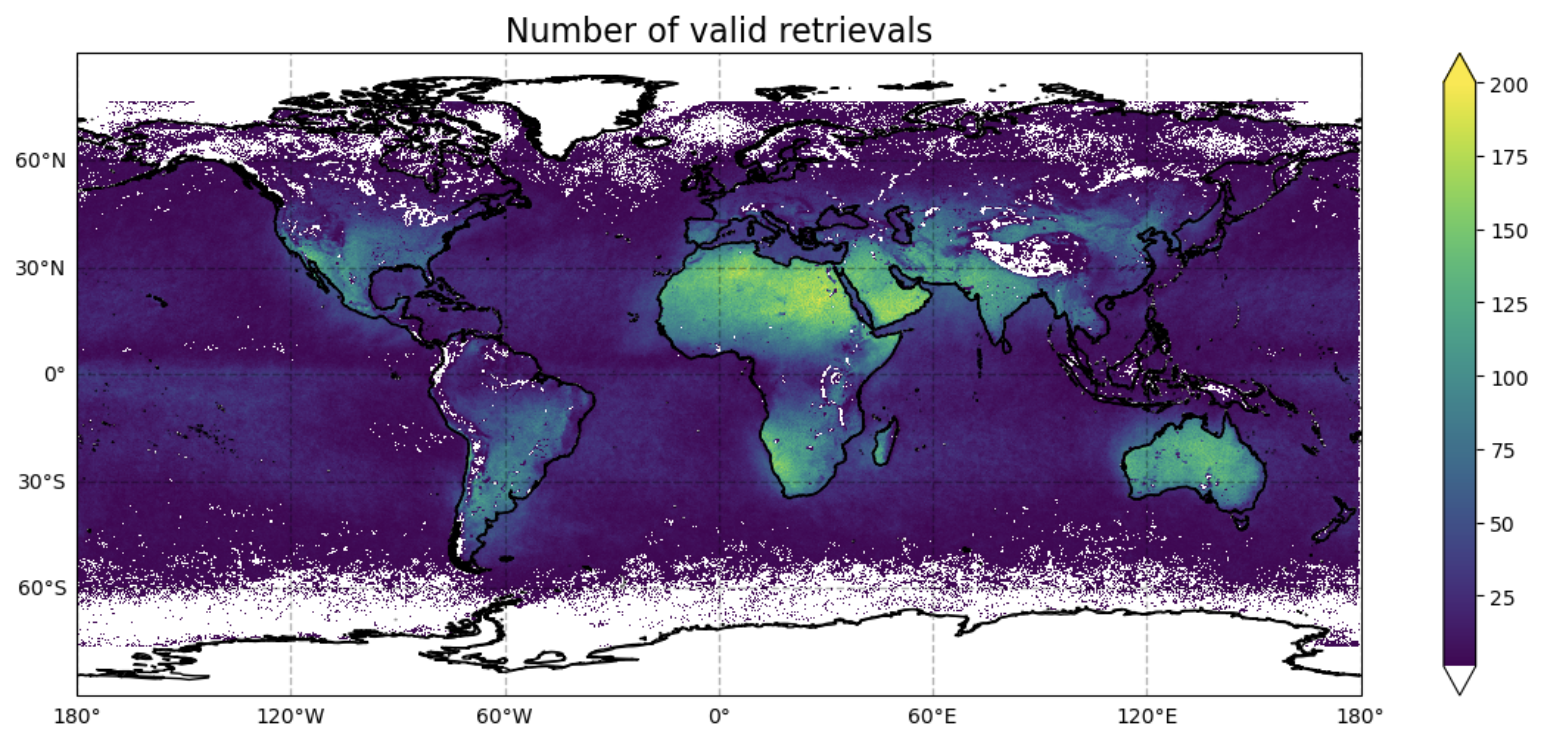
Figure 3Spatial distribution of the number of valid POSP/GRASP retrievals from December 2021 to May 2023.
In order to have a general picture of the POSP/GF-5(02) aerosol and surface product, we present the spatial distribution of POSP/GF-5(02) aerosol and surface main characteristics in Fig. 4 (main aerosol products) and Fig. 5 (main surface products) from December 2021 to May 2023. Figures 4 and 5 show the mean of the main aerosol and surface products over the entire 18-month period of data. As for the detailed aerosol properties, such as SSA (550 nm), AE (440/870), and scale height, we select valid retrievals with POSP AOD (550 nm) > 0.2 on a daily basis and then calculate the mean values shown in Fig. 4d–f because the retrieval accuracy of these detailed parameters strongly depends on the aerosol information content, simplistically aerosol loading (AOD). The main POSP/GF-5(02) aerosol products include spectral AOD, AODF, AODC, and SSA (ranging across UV, VIS, NIR, and SWIR wavelengths), AE (440/870), and aerosol scale height. Note that spectral aerosol absorption optical depth (AAOD) can be derived using and is also provided in the product file. The main POSP/GF-5(02) surface products include full Ross–Li BRDF parameters (aiso(λ), avol,ageom), Maignan–Bréon BPDF Fresnel-based reflection matrix scaling parameter (α), surface white-sky albedo BHRiso (λ), black-sky albedo DHR (λ), and surface normalized difference vegetation index (NDVI).
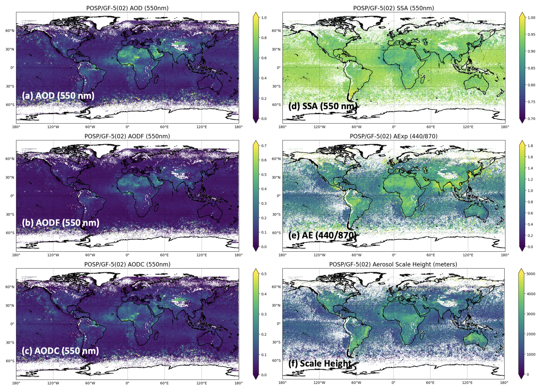
Figure 4Spatial distribution of POSP/GF-5(02) main aerosol products. (a) Aerosol optical depth (AOD). (b) Fine-mode aerosol optical depth (AODF). (c) Coarse-mode aerosol optical depth (AODC). (d) Single-scattering albedo (SSA). (e) Ångström exponent (AE, 440/870). (f) Aerosol scale height (ASH). Note that AOD, AODF, AODC, and SSA are spectrally dependent and provided at UV, VIS, NIR, and SWIR wavelengths. The values represent the mean of each characteristic over the entire 18-month period of POSP data (December 2021 to May 2023). The AOD (550 nm) > 0.2 criterion is used to select high-quality SSA (550 nm), AE (440/870), and ASH on a daily basis before calculating their mean values.
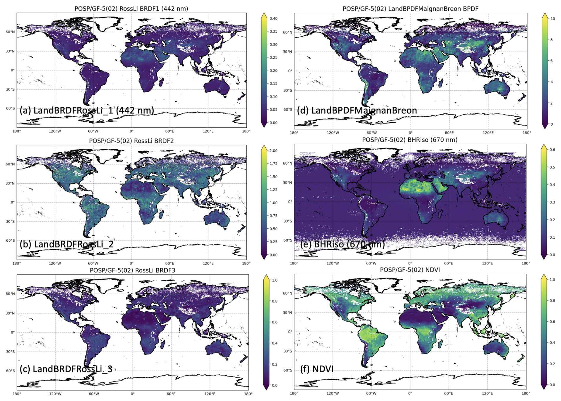
Figure 5Spatial distribution of POSP/GF-5(02) main surface products. (a) Ross–Li BRDF isotropic parameter. (b) Ross–Li BRDF normalized volumetric parameter. (c) Ross–Li BRDF normalized geometric parameter. (d) Maignan–Bréon BPDF. (e) Surface isotropic bihemispherical reflectance (BHRiso or white-sky albedo). (f) Normalized difference vegetation index (NDVI). Note that BRDF1 and BHRiso (white-sky albedo) are spectrally dependent and provided at UV, VIS, NIR, and SWIR wavelengths. The values represent the mean of each characteristic over the entire 18-month period of POSP data (December 2021 to May 2023).
During the first POSP/GF-5(02) processing, we also identify some remaining issues in the current baseline Level 2 products. (i) The cloud and glint mask over the ocean seems too strict, resulting in the percentage of ocean pixels being much lower than expected. (ii) We also identify some existing stripes in the Level 2 aerosol and surface products that are caused by the delay of Level 1 data production; therefore, some Level 1 tracks are recorded until the next day and overwrite the incoming data. These known issues are documented in the data description and are expected to be solved in the next processing.
4.2 Validation of POSP/GF-5(02) aerosol product with AERONET
In order to verify the obtained spatial distribution of POSP aerosol and surface products, the POSP aerosol product is validated with the ground-based AERONET dataset. In order to match satellite retrievals with AERONET measurements, we follow the strategy used in our previous studies (Chen et al., 2020, 2022b, 2024a). Specifically, we use a 3×3 window centered over AERONET sites, and the satellite retrievals with a 3×3 window are averaged. Meanwhile, the available AERONET direct sun AOD, AE, AODF, and AODC products are averaged within ±30 min of the POSP/GF-5(02) satellite overpass, and AERONET inversion SSA products are averaged within ±180 min of the POSP/GF-5(02) satellite overpass. For POSP, we have not yet introduced the quality flags into the product, as for TROPOMI/Sentinel-5p (Litvinov et al., 2024). While some experiences from TROPOMI/Sentinel-5p quality flag definition are used to select high-quality POSP retrievals for validation with AERONET. Basically, any retrieval that meets the three conditions is defined as “high quality” and will be used in validation.
- i.
The relative fitting residual (residual_relative_noise) is smaller than 5 %.
- ii.
Over land, the AOD (865 nm) standard deviation within its 3×3 window (SD_AOD865) is smaller than 0.1 or SD_AOD is smaller than 0.2, where is the mean AOD within the 3×3 window. Over ocean, the SD_AOD865 is smaller than 0.05.
- iii.
The number of valid retrievals within a 3×3 window is greater than or equal to 3.
To quantify the validation results, several standard statistical parameters are used in this study, including the linear correlation coefficient (R), root mean square error (RMSE), bias (BIAS), and the fulfillment of the AOD Global Climate Observing System (GCOS) requirement (i.e., the GCOS fraction), the formulated target requirement for AOD, and the optimal and target requirements formulated for AE, SSA, and surface albedos. Note that the optimal and target requirements are formulated in our previous ESA S5P+I AOD/BRDF project (Litvinov et al., 2024) and are used in TROPOMI/Sentinel-5p validation (Chen et al., 2024a). Specifically, the GCOS requirement for AOD, AODF, and AODC is a maximum of 0.04 or 10 % (whichever is bigger); the optimal requirements for AE, SSA, and surface albedos are 0.3, 0.03, and 0.01, respectively; the target requirement for AOD, AODF, and AODC is a maximum of 0.05 or 20 % (whichever is bigger); and the target requirement for AE, SSA, and surface albedos is 0.5, 0.05, and 0.02, respectively.
Figure 6 shows the validation of the entire year 2022 POSP/GF-5(02) GRASP AOD (550 nm) with AERONET over land (Fig. 6a – linear scale; Fig. 6b – logarithmic scale) and ocean (Fig. 6c – linear scale; Fig. 6d – logarithmic scale). Generally, POSP AOD (550 nm) shows good agreement with AERONET both over land and ocean, with R=0.813, RMSE = 0.114 over land and R=0.861, RMSE = 0.091 over ocean. Moreover, the fulfillment of the GCOS requirement is 47.6 % over land and 54.3 % over ocean. We intercompare the validation results obtained from TROPOMI/GRASP 1-year validation (Chen et al., 2024a; Litvinov et al., 2024). The obtained POSP validation statistical metrics are close to the TROPOMI validation results for QA ≥ 2, where the fulfillment of AOD GCOS requirement is 48.4 % over land and 71.3 % over ocean (Litvinov et al., 2024). Besides, the matchup points are evidently less than TROPOMI, which is associated with POSP's narrower swath width (1850 km) relative to TROPOMI (2600 km). Additionally, the scanning polarimeter has a large deformation at the edge of the track, which leads to the removal of 10 pixels at the edge of the track.
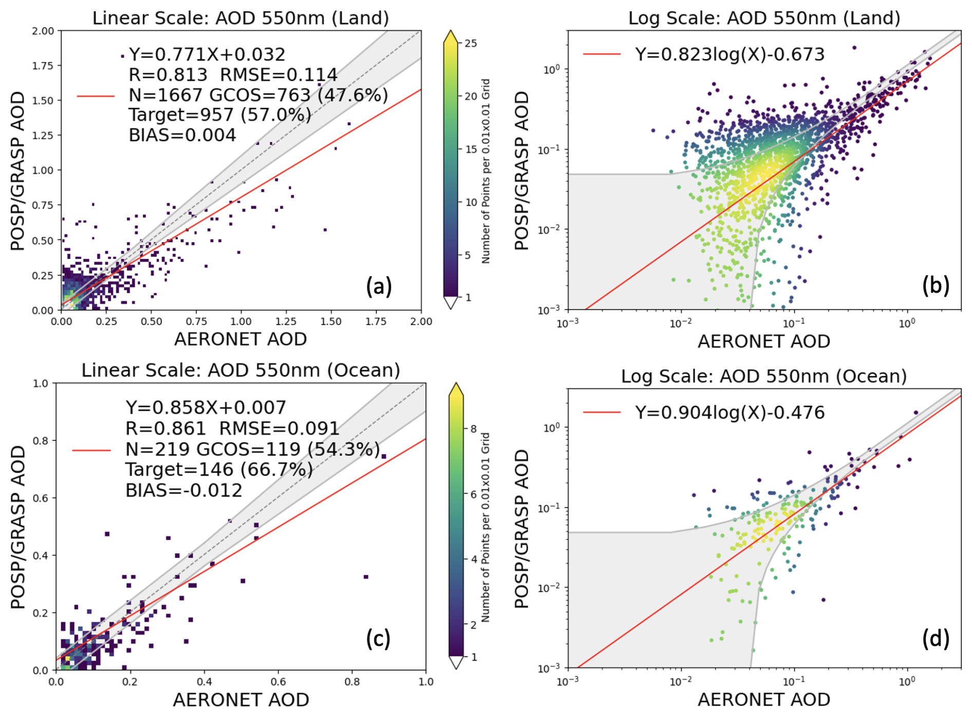
Figure 6Validation of POSP/GF-5(02) GRASP AOD (550 nm) with AERONET over land and ocean for the entire year 2022. (a) POSP AOD validation with a linear scale over land. (b) POSP AOD validation with a logarithmic scale over land. (c) POSP AOD validation with a linear scale over the ocean. (d) POSP AOD validation with a logarithmic scale over the ocean.
The validation of POSP/GF-5(02) GRASP AE (440/870 nm) with AERONET is present in Fig. 7 (Fig. 7a – land; Fig. 7b – ocean). In order to ensure the quality of the satellite AE (440/870 nm) product, we usually filter low AOD cases for AE validation, due to the fact that the calculated AE is very sensitive to small variations in AOD at different wavelengths. For POSP AE validation, we select cases with POSP AOD (550 nm) > 0.2 over land and POSP AOD (550 nm) > 0.2 over ocean. Generally, POSP/GRASP tends to underestimate AE (too large particle size) for small particles (AE > 1.0) and overestimate AE (too small particle size) for large particles (AE < 1.0) over land. This is similar to the results obtained from OLCI and POLDER using the GRASP/Models approach and is associated with the particle size assumption for aerosol models. Moreover, the obtained AE > 1.0 over the Sahara (Fig. 4e) seems to be problematic and is possibly related to polarimetric calibration or SWIR channel radiometric calibration that needs further investigations. Over the ocean, POSP/GRASP tends to overestimate AE (too small particle size) for all ranges of AE. The results are consistent with the AODF and AODC validation presented in Fig. 8 (AODF 550 nm) and Fig. 9 (AODC 550 nm). Specifically, we observe a clear tendency over the ocean that POSP/GRASP slightly overestimates fine-mode AOD (linear scale – Fig. 8c; logarithmic scale – Fig. 8d), while it significantly underestimates coarse-mode AOD (linear scale – Fig. 9c and logarithmic scale – Fig. 9d). The validation of TROPOMI products shows quite similar features (Chen et al., 2024a), which can be related to the fact that the space-borne downward measurements are more sensitive to suspended fine particles than coarse particles near the surface, while the ground-based upward measurements have much more sensitivity to coarse particles near the ground. This is our hypothesis that requires more studies in the future.
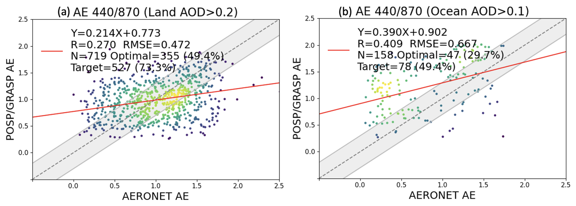
Figure 7Validation of POSP/GF-5(02) GRASP AE (440/870) with AERONET over (a) land and (b) ocean for the entire year 2022.
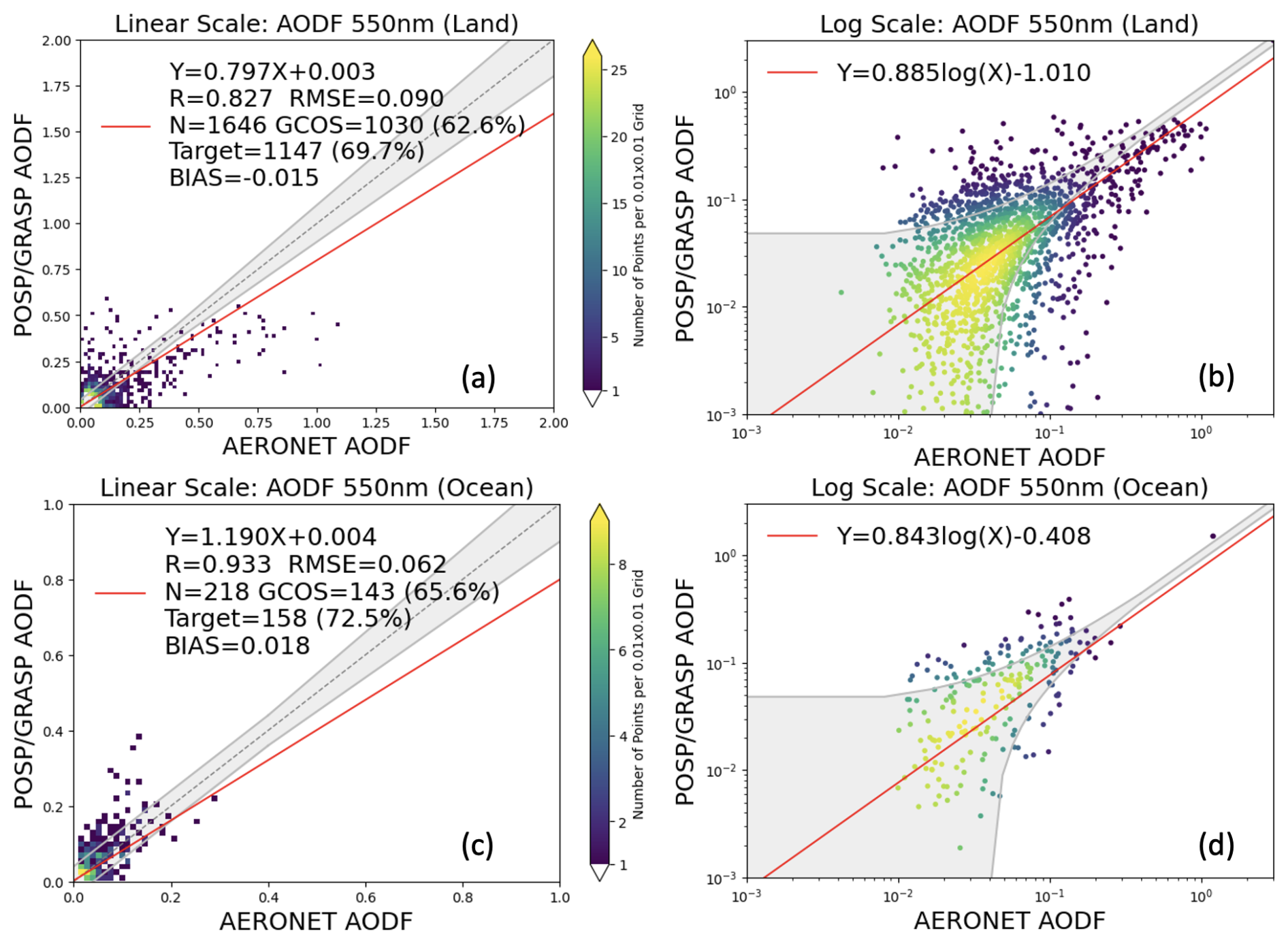
Figure 8Validation of POSP/GF-5(02) GRASP AODF (550 nm) with AERONET over land and ocean for the entire year 2022. (a) POSP AODF validation with linear scale over land. (b) POSP AODF validation with logarithmic scale over land. (c) POSP AODF validation with linear scale over the ocean. (d) POSP AODF validation with logarithmic scale over the ocean.
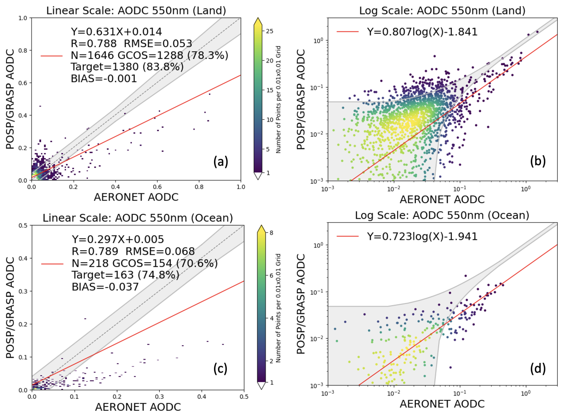
Figure 9Validation of POSP/GF-5(02) GRASP AODC (550 nm) with AERONET over land and ocean for the entire year 2022. (a) POSP AODC validation with linear scale over land. (b) POSP AODC validation with logarithmic scale over land. (c) POSP AODC validation with linear scale over the ocean. (d) POSP AODC validation with logarithmic scale over the ocean.
In addition, we validate POSP/GF-5(02) GRASP SSA (550 nm) with AERONET inversion products for the entire year 2022, and the results are shown in Fig. 10a. The validation of POSP/GF-5(02) GRASP SSA spectral dependence, dSSA(440–670) = SSA(440 nm) − SSA(670 nm), is shown in Fig. 10b. The AERONET Level 2 inversion SSA product is used as a reference, where it contains aerosol loading filtering (AERONET AOD 440 nm > 0.4). For POSP/GRASP SSA, we also select the cases with POSP AOD (550 nm) > 0.2 to ensure the retrieval accuracy. POSP/GRASP SSA shows good consistency with AERONET, with RMSE of 0.040, BIAS of −0.007, and the fulfillment of the SSA optimal (±0.03) and target (±0.05) requirements is 63.0 % and 81.2 %, respectively. Spectral dependence of SSA provides important information about the absorption properties and size-related parameters. AERONET ground-based dSSA is used to infer and quantify fine-/coarse-mode absorption components (BC – black carbon, BrC – brown carbon, and DD – desert dust) and non-absorbing components, such as ammonia–sulfate (Li et al., 2013; Wang et al., 2013). Due to the general difficulty in retrieving the proper SSA spectral dependence, dSSA is rarely provided by satellite products; therefore, it seldom appears in satellite product validation. Previously, the TROPOMI/Sentinel-5p GRASP product demonstrated good performance in capturing the SSA spectral dependence, dSSA(440–670), with 75.8 % of correct cases (Litvinov et al., 2024). Here, POSP/GF-5(02) GRASP dSSA also shows reasonable correspondence with the ground-based AERONET product with 65.5 % of successful separation cases.
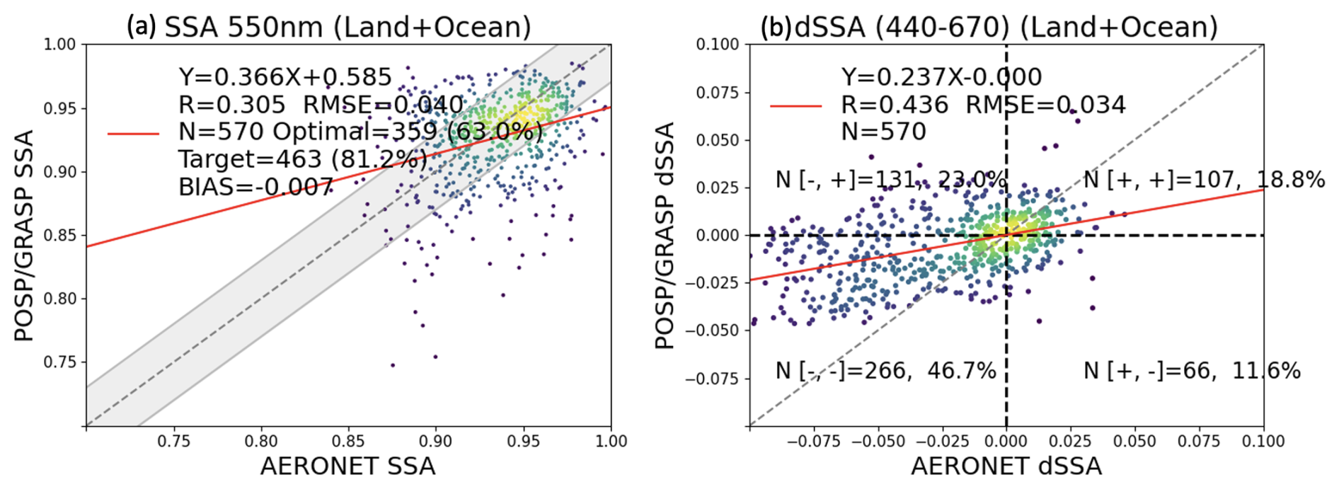
Figure 10Validation of POSP/GF-5(02) GRASP (a) SSA (550 nm) and (b) dSSA (440–670) with AERONET over land and ocean for the entire year 2022.
Table 3Intercomparisons of OLCI/Sentinel-3A, TROPOMI/Sentinel-5p and POSP/GF-5(02) AOD (550 nm), AE (OLCI and POSP: 440/870; TROPOMI: 412/670) and SSA (550 nm) 1-year validation metrics with AERONET reference dataset. The best performance metric is indicated in bold.
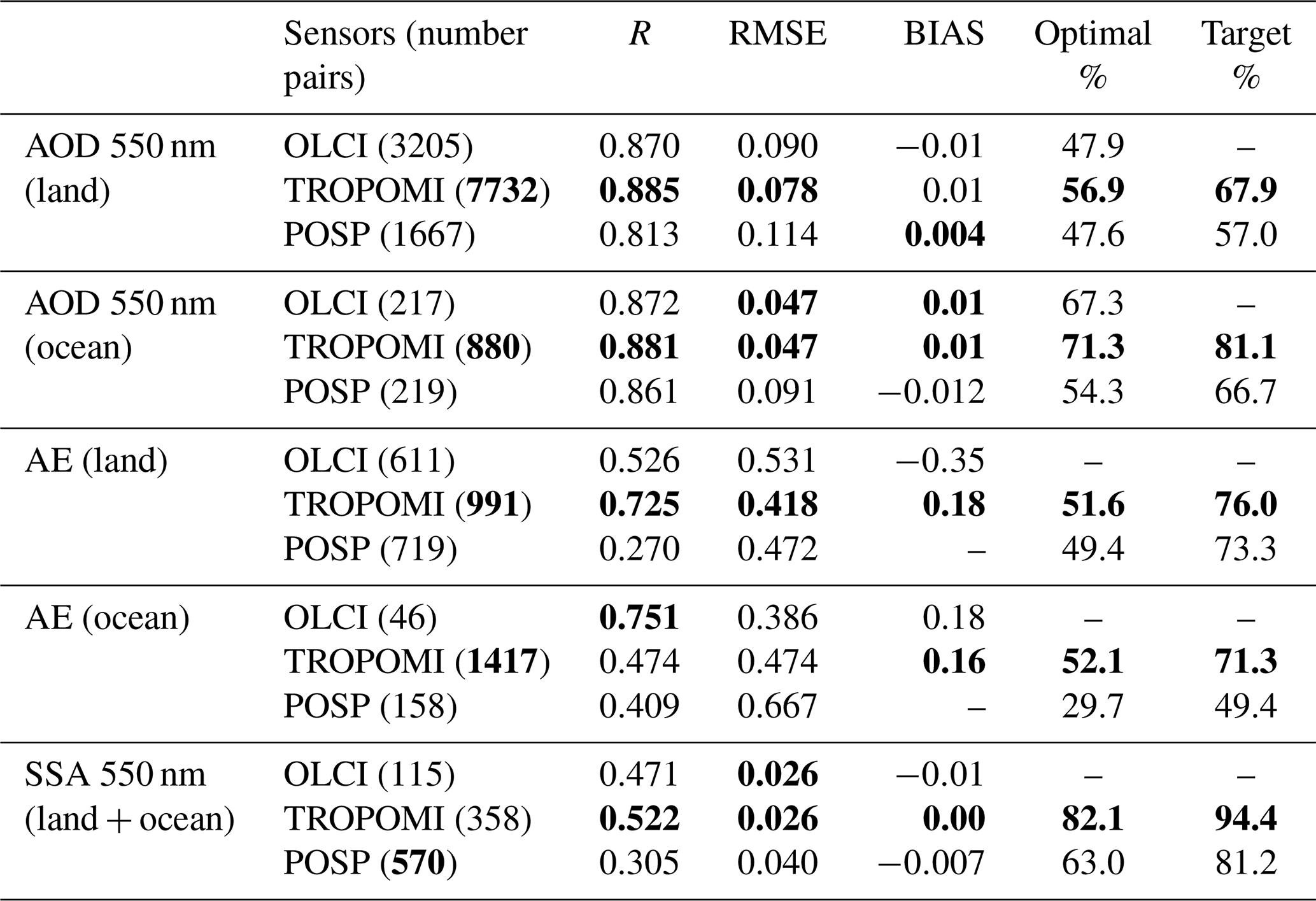
Table 3 summarizes the OLCI/Sentinel-3A, TROPOMI/Sentinel-5p, and POSP/GF-5(02) products generated by the GRASP algorithm, 1-year AOD, AE, and SSA 1-year validation metrics with the AERONET reference dataset. The TROPOMI AE (412/670) is used, while OLCI and POSP AE are calculated from 440 to 870 nm. AOD and SSA at 550 nm validation results are used for the intercomparison. Note, the 1-year validation is performed for different years, for example, OLCI (June 2018 to May 2019), TROPOMI (March 2019 to February 2020), and POSP (January to December 2022). The OLCI/Sentinel-3A validation metrics are adopted from Chen et al. (2022b). TROPOMI/Sentinel-5p validation results are obtained from Chen et al. (2024a) and Litvinov et al. (2024) in which QA = 3 is used for AOD (550 nm) over land, QA ≥ 2 for AOD (550 nm) over ocean, and QAExtend = 3 for AE over land, QAExtend ≥ 2 for AE over ocean, QAExtend = 3 for SSA (550 nm) over land and ocean. Basically, the fulfillment of the AOD GCOS requirement over land varies from ∼48 % (POSP and OLCI) to 57 % (TROPOMI). Over the ocean, POSP AOD performs slightly worse than OLCI and TROPOMI, with a GCOS fraction of 54.3 % for POSP, relative to 67.3 % for OLCI and 71.3 % for TROPOMI. For AE, all three products are qualitatively good at separating fine-/coarse-mode dominant cases, while quantitatively there is a clear tendency in the over-/underestimation of AE for fine-/coarse-mode cases that needs further refinement, particularly in the particle size assumption for coarse mode in the Models approach. For SSA, for OLCI validation, a larger AOD threshold (AOD > 0.5) is used to select high-quality retrievals, which leads to a relatively small number of available points. TROPOMI shows slightly better performance than POSP in terms of RMSE (0.026 vs. 0.040) and fulfillment of optimal requirement (±0.03) (82.1 % vs. 63.0 %).
Overall, the AERONET validation results show that the POSP/GF-5(02) GRASP aerosol product has good consistency with the ground-based AERONET aerosol reference dataset, not only for AOD but also for detailed aerosol properties including AODF, AODC, AE, and SSA. The validation results are basically comparable with previous aerosol products, such as OLCI/GRASP and TROPOMI/GRASP, in which the TROPOMI product outperforms the other two products for most of the statistical metrics. POSP AOD validation performance is comparable with OLCI, while AE over land from POSP seems slightly better than OLCI, and the number of AE and SSA retrievals available for validation is also higher. This is a preliminary validation exercise for the POSP aerosol product to obtain a general picture of the product quality and the instrument performance. In the future, more in-depth analysis of the product will be needed once more data are produced, and the definition of the pixel-level quality flag is also on the to-do list for the POSP product.
4.3 Intercomparison of POSP, MODIS, and VIIRS aerosol and surface products
In this section, the POSP/GF-5(02) GRASP aerosol and surface product is intercompared with widely used NOAA and NASA aerosol and surface products, including NOAA-20 VIIRS DB aerosol product (AERDB_L2_VIIRS_NOAA-20) and MCD43C3 surface white-sky albedo. In order to compare the products at the same grid, we therefore re-grid POSP/GRASP 10 km, VIIRS/DB 6 km, and MCD43C3 0.05° pixels onto a common 0.2°×0.2° grid box, and then the intercomparisons are performed for all 0.2°×0.2° grid boxes globally. We still use similar criteria to select high-quality retrievals for re-gridding. Specifically, for the POSP/GF-5(02) product, we require the relative fitting residual to be smaller than 5 % over land and ocean; for VIIRS/DB, we use the original retrievals with quality assurance QA ≥ 2 over land and ocean.
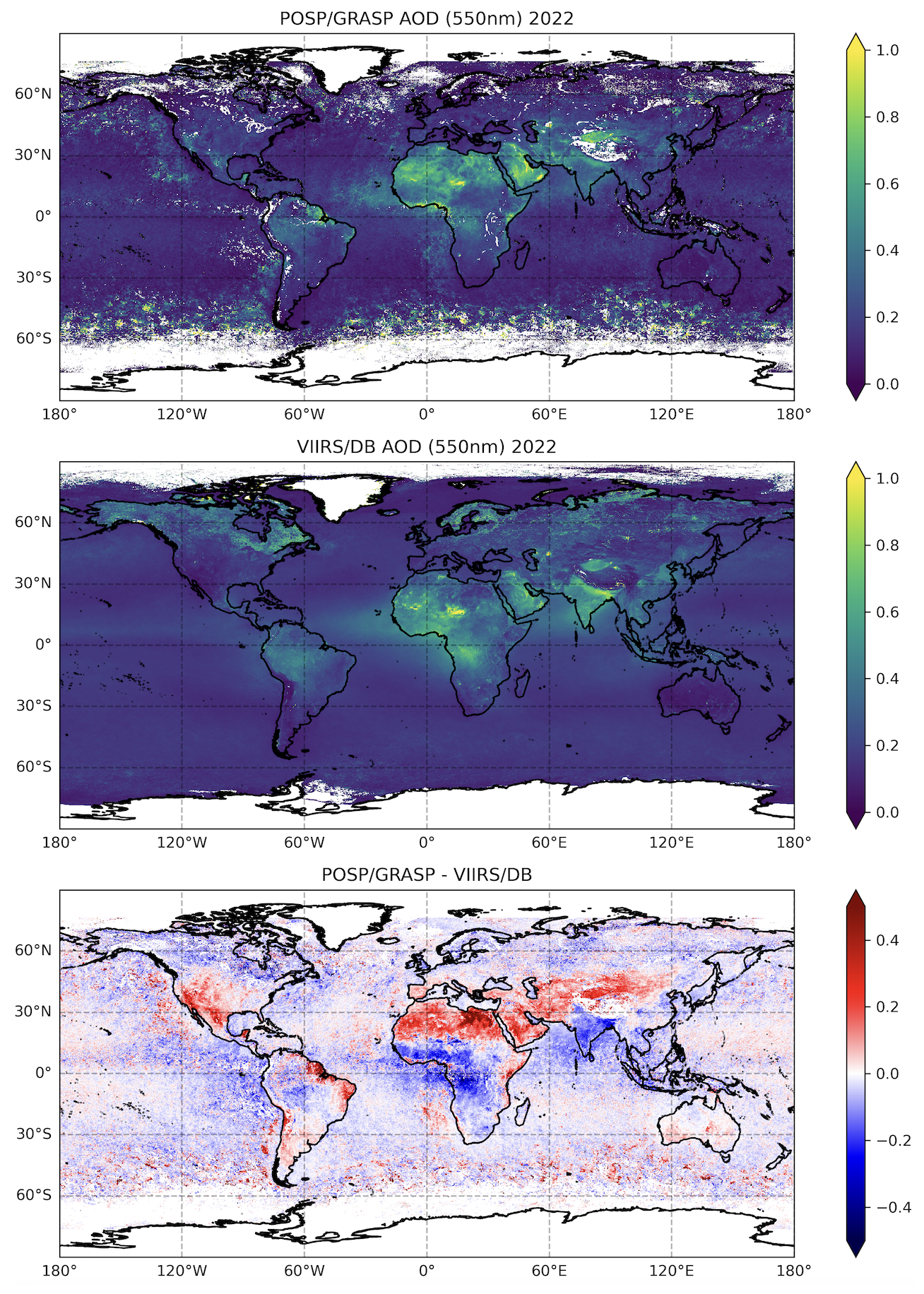
Figure 11Spatial distribution of the 1-year (2022) AOD (550 nm) from GF-5(02) POSP/GRASP and NOAA-20 VIIRS/DB. The pixel-level difference of AOD 550 nm on a daily basis between POSP and VIIRS averaged over a year is presented at the bottom as POSP/GRASP–VIIRS/DB.
Figure 11 shows the global spatial distribution of GF-5(02) POSP/GRASP (Fig. 11a) and NOAA-20 VIIRS/DB (Fig. 11b) AOD (550 nm) in 2022, and the pixel-level difference of daily AOD (550 nm) averaged over the entire year (Fig. 11c). On the one hand, the two products capture the global major aerosol features, such as Sahara dust, Taklimakan dust, southern African smoke, South American smoke, and high AOD over the Indo-Gangetic Plain (IGP). On the other hand, the two AOD products show non-negligible differences in the AOD absolute values with spatial variability. For example, POSP/GRASP AOD (550 nm) is generally 0.05–0.15 higher than VIIRS/DB over the desert regions (the Sahara, Taklimakan, and Arabian Peninsula), and POSP/GRASP AOD (550 nm) is slightly 0.03–0.10 lower than VIIRS/DB over the central and southern African biomass-burning region and the Indian region. Statistically, the 1-year global all grid boxes' AOD (550 nm) metrics between POSP/GRASP and VIIRS/DB are presented in Fig. 12. Based on ∼10 million matchup grid boxes (5.3 million over land and 4.4 million over ocean), the grid-to-grid AOD (550 nm) linear correlation coefficients (R) between POSP/GRASP and VIIRS/DB are 0.675 over land and 0.746 over ocean, with differences (POSP-VIIRS) +0.043 (1σ=0.182) over land and −0.029 (1σ=0.074) over ocean. Generally, the AOD intercomparison results are reasonable, while not as good as our previous exercise for TROPOMI/Sentinel-5p vs. VIIRS/SNPP (Chen et al., 2024a). One intrinsic reason is that the difference in satellite overpass time is a few hours between GF-5(02) and NOAA-20, in contrast with a few minutes between Sentinel-5p and SNPP. Besides, there are some potential reasons that need to be verified in the future, for example, the data quality, calibration accuracy, and cloud mask. Additionally, the ocean AOD (550 nm) validation in Fig. 6b shows that there seem to be some outliers in the POSP ocean products; for example, the RMSE is 0.091 in contrast with typical values of around 0.04–0.05 obtained from our previous processing of TROPOMI and OLCI. Meanwhile, the intercomparison between POSP and VIIRS AOD (550 nm) over the ocean also shows larger SD of 0.074 (Fig. 12) than 0.055 between OLCI and MODIS, and 0.033 between TROPOMI and VIIRS, indicating less stability in POSP AOD over the ocean. There are three potential reasons: (i) the cloud mask does not function well and leads to cloud contamination in some pixels (Fig. 11), which may be an intrinsic issue due to its relatively coarse spatial resolution (6.4–20 km) from POSP; (ii) there are radiometric calibration issues in POSP SWIR channels; and (iii) the wind speed is not used to constrain angular properties of the ocean surface BRDF in POSP processing, which has been shown to stabilize ocean AOD retrievals in previous OLCI and TROPOMI processing.
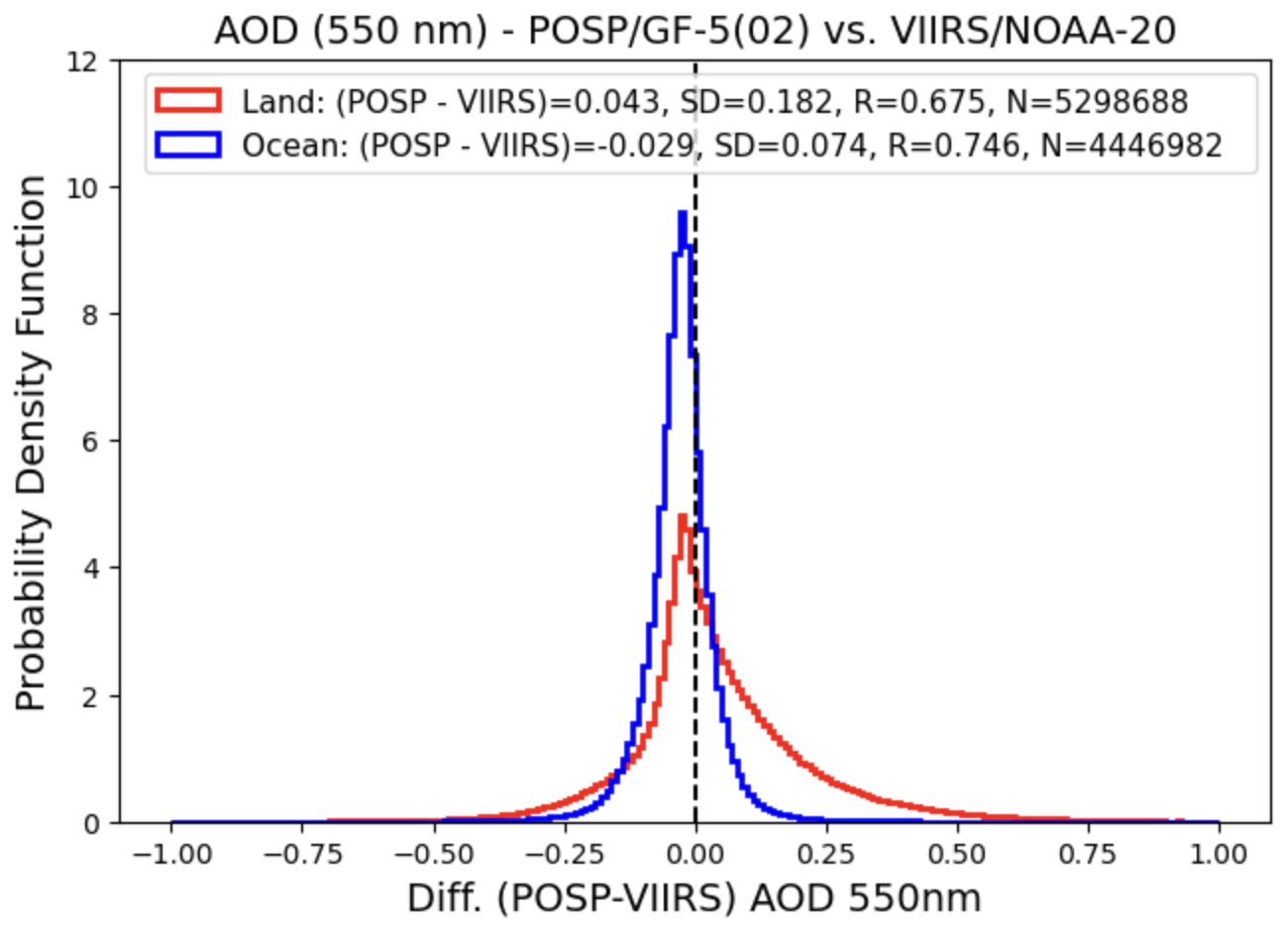
Figure 12Probability density function (PDF) of all global 0.2°×0.2° grid box AOD (550 nm) differences between VIIRS/DB and POSP/GRASP over land and ocean.
Figure 13 shows the global spatial distribution of GF-5(02) POSP/GRASP and NOAA-20 VIIRS/DB AODF (550 nm) and AODC (550 nm) in 2022, and the pixel-level difference of daily AODF and AODC averaged over the entire year. Note that the VIIRS/DB fine-mode fraction (FMF) is only available over the ocean, provided by the Satellite Ocean Aerosol Retrieval (SOAR) algorithm (Sayer et al., 2018a, b). The intercomparison of AODF and AODC is performed over the ocean only. The 1-year global all-grid-boxes AODF (550 nm) and AODC (550 nm) metrics between POSP/GRASP and VIIRS/DB are presented in Fig. 14. Some clear tendencies are identified for AODF and AODC over the ocean. Specifically, POSP/GRASP AODF (550 nm) is almost everywhere 0.01 higher than VIIRS/DB, while POSP/GRASP AODC (550 nm) is generally 0.02–0.05 lower than VIIRS/DB. These results are also supported by AERONET validation, where POSP seems to overestimate AODF while underestimating AODC over the ocean (Figs. 8b and 9b), and in the AE validation (Fig. 7b), where POSP seems to underestimate particle size (overestimate AE) over the ocean. This is potentially associated with the coarse models (dust and oceanic maritime) used in GRASP/Models. Overall, the agreement between the two satellites' AOD, AODF, and AODC products generated with two independent algorithms is generally reasonable, with R around 0.7–0.75, RMSE around 0.18 over land and 0.08 over the ocean for total AOD, and RMSE around 0.05 for AODF and AODC over the ocean.
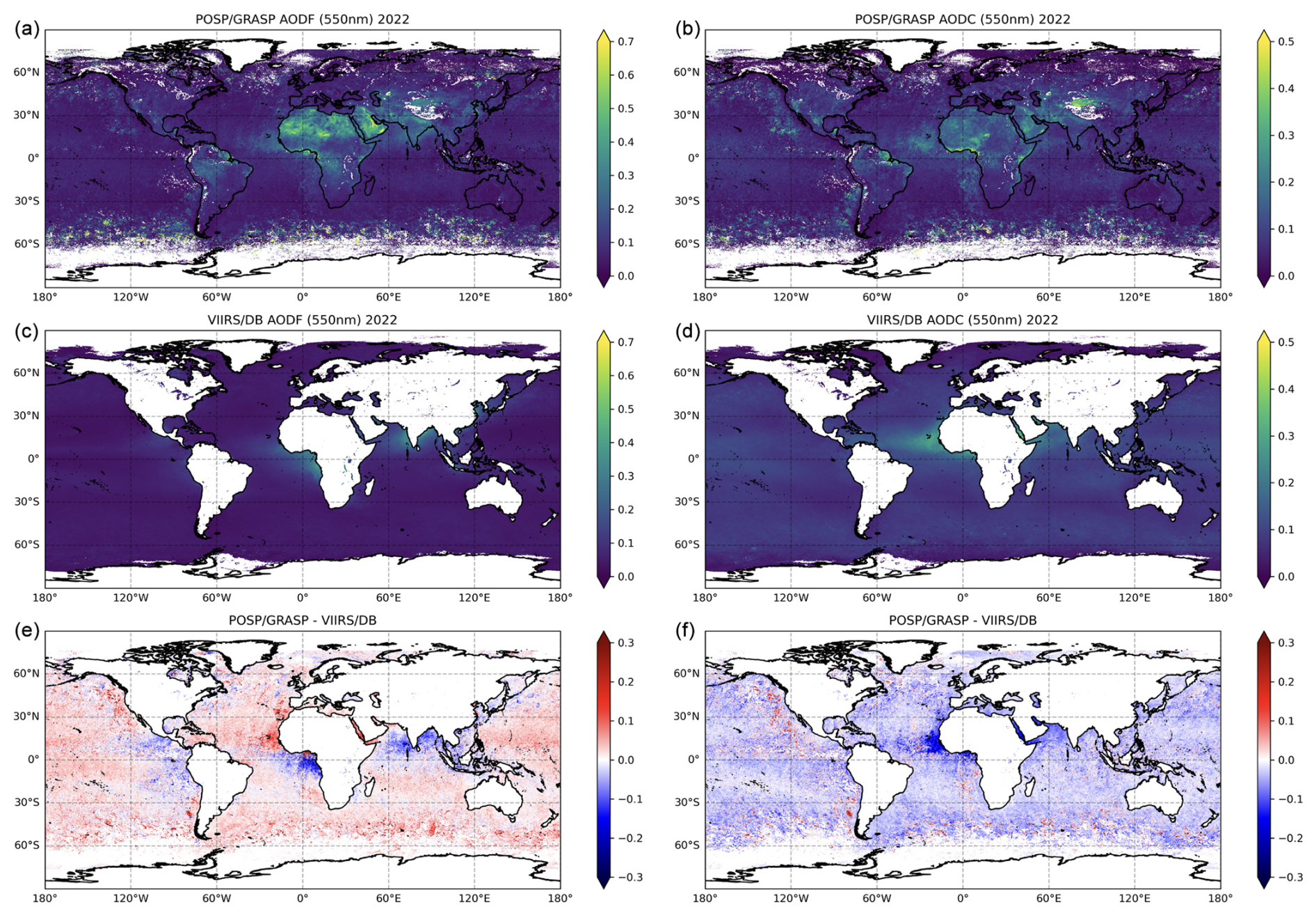
Figure 13Spatial distribution of the 1-year (2022) (a, c, e) AODF (550 nm) and (b, d, f) AODC (550 nm) from GF-5(02) POSP/GRASP and NOAA-20 VIIRS/DB. The pixel-level difference of AODF and AODC at 550 nm on a daily basis between POSP and VIIRS averaged over a year is presented at the bottom as POSP/GRASP–VIIRS/DB.
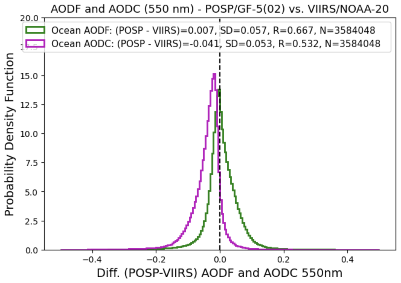
Figure 14Probability density function (PDF) of all global 0.2°×0.2° grid box AODF (550 nm) and AODC (550 nm) differences between VIIRS/DB and POSP/GRASP over ocean.
For the surface product, we intercompare POSP/GF-5(02) GRASP and MODIS MCD43C3 surface white-sky albedos at blue (442 nm vs. MODIS Band 3), red (670 nm vs. MODIS Band 1), NIR (865 nm vs. MODIS Band 2), and SWIR (2254 nm vs. MODIS Band 7) channels. The intercomparison strategy is the same as in our previous study (Chen et al., 2022b, 2024a), where all global 0.2°×0.2° grid box intercomparisons are performed using monthly means. We should note that the MODIS MCD43C3 product is an accumulation of 16 d TERRA and AQUA data and is weighted to the day of interest; therefore, we use the data on the 15th day of each month to approximate the MODIS monthly mean surface albedos. In addition, the differences in the channel center wavelength and the bandwidth between POSP and MODIS differ. Therefore, the objective of the intercomparison exercise is to get a general idea of the two surface albedo products and analyze some trends that may be related to instrument performance.
Figure 15 shows the spatial distribution of 1-year POSP/GF-5(02) and MODIS MCD43C3 BHRiso (white-sky albedo) at blue, red, NIR, and SWIR channels. Statistically, the 1-year global all-grid-boxes BHRiso metrics between POSP/GRASP and MODIS MCD43 are presented in Fig. 16a, together with the monthly variation of the white-sky albedo differences between POSP and MODIS in 2022 in Fig. 16b (visible channels) and Fig. 16c (NIR and SWIR channels). The surface optimal (±0.01) and target (±0.02) requirements used in this study are formulated in the ESA S5P+I AOD/BRDF project (Litvinov et al., 2024). Because the surface is the dominant TOA signal in general, we observe quite consistent global spatial variability between POSP and MODIS BHRiso at blue, red, NIR, and SWIR channels. The best agreement between the two products is observed at the two visible channels (blue and red), especially at 670 nm. The global differences (POSP-MODIS) are around 0.002–0.003, with 1σ variation of about 0.023, and the fulfillment of target and optimal requirements are ∼75 % and ∼50 %, respectively. While the differences become large at NIR (−0.022, 1σ=0.038) and SWIR (−0.046, 1σ=0.057) channels. In addition, the SWIR channel difference is even larger (around −0.08 to −0.1) over Sahara and other desert regions, which is potentially connected with the overestimation of fine-mode particles over desert regions (Fig. 4b and e). Certainly, we must acknowledge the difference between the two channels (POSP 2254 nm vs. MODIS 2105–2155 nm). We should note that the spectral difference can be quite significant in this range due to the absorption of different surfaces (Caplan and Huemmrich, 2025). Taking into account the new instrument POSP and the general challenges with the calibration of SWIR channels, we infer that the calibration of POSP SWIR channels may underestimate high values. This is an inference from the intercomparison analysis of indirect surface albedos that needs further verification with the Level 1 calibration team.
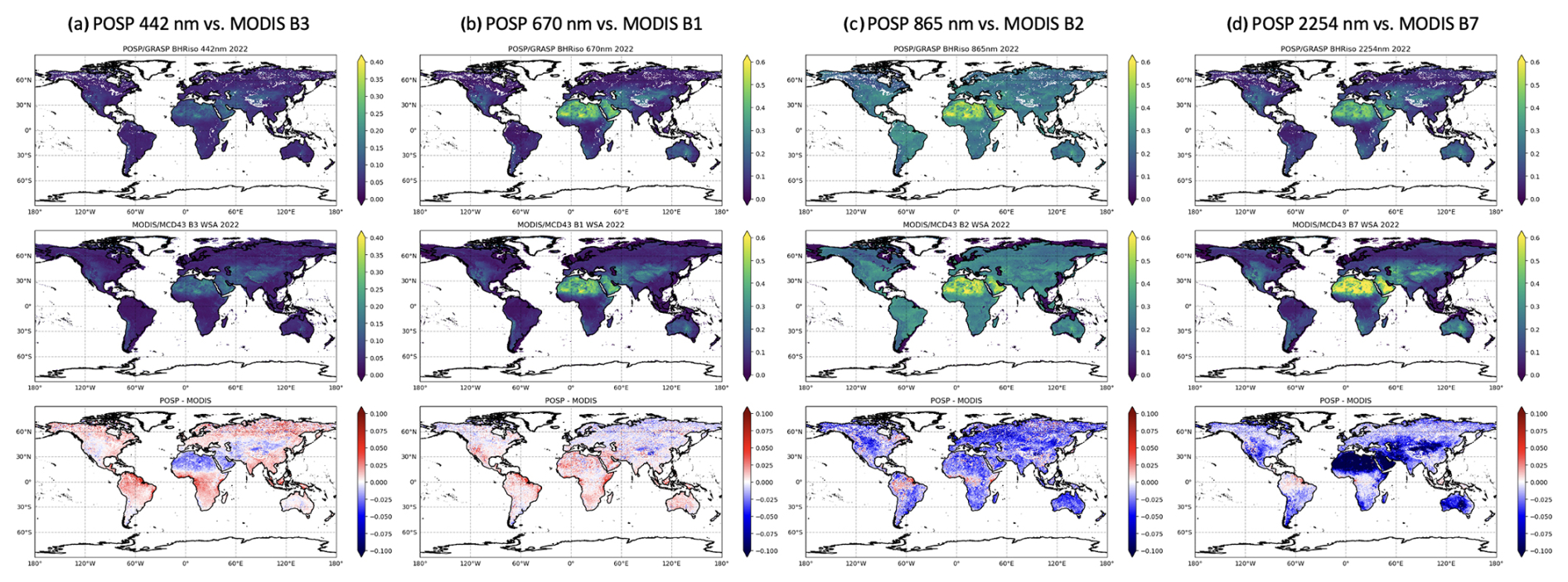
Figure 15Spatial distribution of the 1-year (2022) POSP/GF-5(02) and MODIS MCD43 BHRiso (white-sky albedo) at blue, red, NIR, and SWIR channels. (a) POSP 442 nm vs. MODIS B3 459–479 nm. (b) POSP 670 nm vs. MODIS B1 620–670 nm. (c) POSP 865 nm vs. MODIS B2 841–876 nm. (d) POSP 2254 nm vs. MODIS B7 2105–2155 nm. The pixel-level difference on a monthly basis between POSP and VIIRS averaged over a year is presented at the bottom as POSP/GRASP–VIIRS/DB.
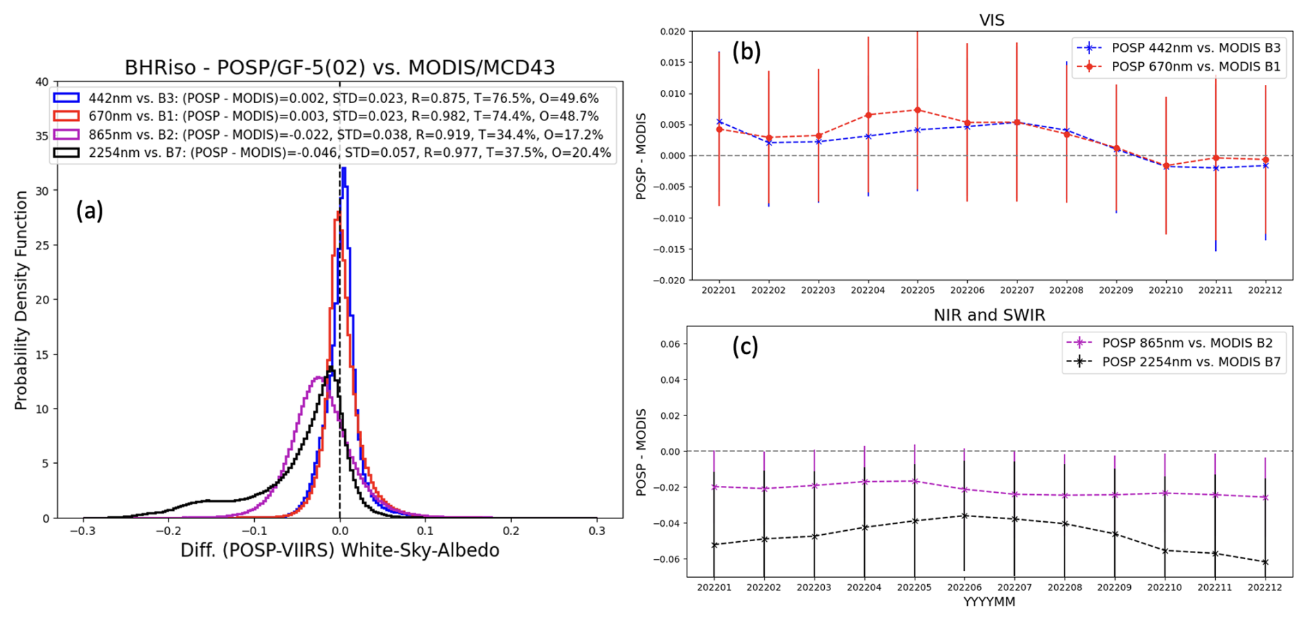
Figure 16(a) Probability density function (PDF) of all global 0.2°×0.2° grid box white-sky albedo differences between MODIS/MCD43 and POSP/GRASP. Monthly variation of the white-sky albedo differences between POSP and MODIS in 2022: (b) visible channels and (c) NIR and SWIR channels. The error bar indicates the 1σ variation of the differences (POSP–MODIS).
The developed POSP/GF-5(02) aerosol and surface products are publicly available and registered at https://doi.org/10.57760/sciencedb.14748 (Chen et al., 2024c).
In this study, we provide a detailed description of the development of aerosol and surface Level 2 product and the processing scheme for the first space-borne UV–VIS–NIR–SWIR multi-spectral cross-track scanning polarimeter (POSP) on board the Chinese GF-5(02) satellite based on the GRASP/Models approach. Since POSP is a new polarimeter collecting both intensity and polarimetric measurements at UV, VIS, NIR, and SWIR channels, we intend to verify the performance and feasibility of the instrument through the development of aerosol and surface products, validation, and the intercomparison with reference datasets and other independent satellite products. The total 18 months of POSP/GF-5(02) measurements from December 2021 to May 2023 was processed, and the obtained global aerosol and surface properties are evaluated and delivered as the baseline POSP product. We will continue to process the data and deliver up-to-date POSP/GF-5(02) aerosol and surface products.
Generally, we found the POSP single-view, multi-spectral (UV–VIS–NIR–SWIR) polarimetric measurements provide rich information content for aerosol and surface characterization, not only for total aerosol optical depth but also for detailed properties including aerosol size, absorption, layer height, type, etc. We provide spectral AOD, AODF, AODC, AE, and SSA ranging from UV to SWIR, and aerosol scale height and columnar volume concentration for four aerosol models: BB (BC and OC), urban (sulfate), oceanic (sea salt), and dust (mineral dust) in the POSP/GF-5(02) aerosol product. In addition, the POSP/GF-5(02) surface product includes full BRDF and BPDF parameters, derived black-sky and white-sky albedos, and vegetation index NDVI.
The validation of the full-year 2022 POSP aerosol product against ground-based AERONET reference data shows generally good agreement. Specifically, the correlation coefficients R for AOD (550 nm) are around 0.82–0.87 over land and ocean, and RMSEs are within 0.12 over land and ∼0.09 over ocean. The fulfillment of the AOD GCOS requirement is around 48 % and 55 % over land and ocean, respectively. For aerosol-particle-size-related parameters (AODF, AODC, and AE), POSP AODF (550 nm) shows good consistency with the AERONET SDA product with R around 0.8 both over land and ocean, and the bias is within 0.015. POSP AODC (550 nm) has a good correlation coefficient with AERONET with R of 0.93 over land and 0.79 over ocean, while POSP tends to overestimate (0.02) AODC over land and underestimate AODC (0.03–0.04) over ocean. Similarly, the validation of POSP AE indicates that POSP tends to underestimate particle size (overestimate AE) over the ocean, and this tendency is also observed over bright land surfaces, especially over desert regions where POSP tends to overestimate AE and fine-mode AOD.
The POSP/GF-5(02) aerosol and surface products are then intercompared with VIIRS/NOAA-20 DB aerosol and MODIS MCD43 surface products globally at a common 0.2°×0.2° grid box. Based on the intercomparison over approximately 10 million grid boxes, POSP/GRASP and VIIRS/DB total AOD (550 nm) show reasonable agreement with R around 0.7–0.75, RMSE around 0.18 over land and 0.08 over ocean, and POSP global mean AOD (550 nm) is approximately 0.04 higher than VIIRS over land and 0.03 lower than VIIRS over ocean. Over land, POSP tends to report higher AOD than VIIRS over desert regions, where POSP seems to always overestimate the fine-mode contribution. This phenomenon can be associated with the POSP polarimetric calibration or SWIR channel radiometric calibration. For AODF and AODC over ocean, POSP/GRASP generally reports higher AODF and lower AODC than VIIRS/DB. This can also be connected with POSP radiometric calibration and the coarse-mode assumptions used in the GRASP/Models approach. The intercomparison between POSP/GRASP and MODIS MCD43 surface white-sky albedos shows overall good consistency in VIS channels (blue and red), while POSP tends to report smaller white-sky albedos at NIR (−0.02) and SWIR (−0.045) channels than those from MODIS, which is possibly due to signal attenuation that requires recalibration.
In the past, for Chinese satellite missions, the ground segment has been somewhat insufficiently prioritized. Here, some lessons are learned during the development of the global aerosol and surface products from the POSP on board the GF-5(02) satellite. (i) Some useful and important pixel-level identifications or classifications are missing or need improvement in Level 1 data. For example, the cloud mask is not well documented and does not function well. We recommend including additional surface identifications (such as coastline, mixed land and water, snow, ice, and saline lakes) and auxiliary data, potentially from reanalysis datasets (such as gas concentrations, wind speed, etc.), which are very helpful for developing high-quality Level 2 products. (ii) On-orbit calibration requires continuous efforts and consistent iteration with proper versioning of the product. Overall, the POSP/GF-5(02) baseline aerosol and surface Level 2 product is developed and will continue to process and release the product, which verifies the good performance of the first space-borne multi-spectral cross-track scanning polarimeter (POSP).
CC, ZQL, and JH conceived the initial idea for the study. XL, ZHL, GX, MB, and ZQ supported the Level 1 data preparation and Level 2 data processing resources. CC, OD, PL, and DF developed and supported the retrieval scheme. CC, ZQL, XL, and HG performed the retrieval tests and carried out the processing. CC and ZQL wrote the paper with comments from all the authors.
The contact author has declared that none of the authors has any competing interests.
Publisher's note: Copernicus Publications remains neutral with regard to jurisdictional claims made in the text, published maps, institutional affiliations, or any other geographical representation in this paper. While Copernicus Publications makes every effort to include appropriate place names, the final responsibility lies with the authors.
This research was supported by the National Key R&D Program of China (grant no. 2024YF0811200), the National Outstanding Youth Foundation of China (grant no. 41925019), and the National Natural Science Foundation of China (grant nos. 42275144 and 42405130). We would like to thank the AERONET, MODIS, and VIIRS teams for producing the datasets and making them available to the community.
This paper was edited by Jing Wei and reviewed by three anonymous referees.
Bréon, F.-M., Vermeulen, A., and Descloitres, J.: An evaluation of satellite aerosol products against sunphotometer measurements, Remote Sens. Environ., 115, 3102–3111, https://doi.org/10.1016/J.RSE.2011.06.017, 2011.
Cairns, B., Waquet, F., Knobelspiesse, K., Chowdhary, J., and Deuzé, J.-L.: Polarimetric remote sensing of aerosols over land surfaces, Satellite Aerosol Remote Sensing over Land, Springer, 295–325, https://doi.org/10.1007/978-3-540-69397-0_10, 2009.
Cao, Y., Chen, C., Yu, H., Sun, X., Liu, X., Gu, H., Xie, Y., Hong, J., and Li, Z.: Monitoring of aerosol optical-microphysical properties from DPC/GF-5(02): A case study of dust event in North China Plain, Atmos. Environ., 352, 121193, https://doi.org/10.1016/J.ATMOSENV.2025.121193, 2025.
Caplan, S. and Huemmrich, K. F.: Unveiling PACE OCI's hyperspectral terrestrial data products, Remote Sens. Lett., 16, 422–433, https://doi.org/10.1080/2150704X.2025.2470905, 2025.
Chen, C., Dubovik, O., Fuertes, D., Litvinov, P., Lapyonok, T., Lopatin, A., Ducos, F., Derimian, Y., Herman, M., Tanré, D., Remer, L., Lyapustin, A., Sayer, A., Levy, R., Hsu, N. C., Descloitres, J., Li, L., Torres, B., Karol, Y., Herrera, M., Herreras, M., Aspetsberger, M., Wanzenboeck, M., Bindreiter, L., Marth, D., Hangler, A., and Federspiel, C.: Validation of GRASP algorithm product from POLDER/PARASOL data and assessment of multi-angular polarimetry potential for aerosol monitoring, Earth Syst. Sci. Data, 12, 3573–3620, https://doi.org/10.5194/essd-12-3573-2020, 2020.
Chen, C., Dubovik, O., Schuster, G. L., Chin, M., Henze, D. K., Lapyonok, T., Li, Z., Derimian, Y., and Zhang, Y.: Multi-angular polarimetric remote sensing to pinpoint global aerosol absorption and direct radiative forcing, Nat. Commun., 13, 1–11, https://doi.org/10.1038/s41467-022-35147-y, 2022a.
Chen, C., Dubovik, O., Litvinov, P., Fuertes, D., Lopatin, A., Lapyonok, T., Matar, C., Karol, Y., Fischer, J., Preusker, R., Hangler, A., Aspetsberger, M., Bindreiter, L., Marth, D., Chimot, J., Fougnie, B., Marbach, T., and Bojkov, B.: Properties of aerosol and surface derived from OLCI/Sentinel-3A using GRASP approach: Retrieval development and preliminary validation, Remote Sens. Environ., 280, 113142, https://doi.org/10.1016/j.rse.2022.113142, 2022b.
Chen, C., Litvinov, P., Dubovik, O., Bindreiter, L., Matar, C., Fuertes, D., Lopatin, A., Lapyonok, T., Lanzinger, V., Hangler, A., Aspetsberger, M., de Graaf, M., Tilstra, L. G., Stammes, P., Dandocsi, A., Gasbarra, D., Fluck, E., Zehner, C., and Retscher, C.: Extended aerosol and surface characterization from S5P/TROPOMI with GRASP algorithm. Part II: Global validation and Intercomparison, Remote Sens. Environ., 313, 114374, https://doi.org/10.1016/J.RSE.2024.114374, 2024a.
Chen, C., Litvinov, P., Dubovik, O., Fuertes, D., Matar, C., Miglietta, F., Pepe, M., Genesio, L., Busetto, L., Bindreiter, L., Lanzinger, V., de Graaf, M., Tilstra, G., Stammes, P., and Retscher, C.: Retrieval of Aerosol and Surface Properties at High Spatial Resolution: Hybrid Approach and Demonstration Using Sentinel-5p/TROPOMI and PRISMA, J. Geophys. Res.-Atmos., 129, e2024JD041041, https://doi.org/10.1029/2024JD041041, 2024b.
Chen, C., Lei, X., Liu, Z., Gu, H., Hong, J., and Li, Z.: Aerosol and surface products from cross-track scanning polarimeter POSP onboard GF-5(02) satellite (December 2021–May 2023) [DS/OL], V1, Science Data Bank [data set], https://doi.org/10.57760/sciencedb.14748, 2024c.
Chen, F., Luo, D., Li, S., Yang, B., Sun, L., Ge, S., and Hong, J.: The Operational Inflight Radiometric Uniform Calibration of a Directional Polarimetric Camera, Remote Sens., 13, 3823, https://doi.org/10.3390/RS13193823, 2021a.
Chen, L., Shang, H., Fan, M., Tao, J., Husi, L., Zhang, Y., Wang, H., Cheng, L., Zhang, X., Wei, L., Li, M., Zou, M., and Liu, D.: Mission overview of the GF-5 satellite for atmospheric parameter monitoring, Natl. Remote Sens. Bull., 25, 1917–1931, https://doi.org/10.11834/JRS.20210582, 2021b.
Chen, L., Letu, H., Fan, M., Shang, H., Tao, J., Wu, L., Zhang, Y., Yu, C., Gu, J., Zhang, N., Hong, J., Wang, Z., and Zhang, T.: An Introduction to the Chinese High-Resolution Earth Observation System: Gaofen-1∼7 Civilian Satellites, J. Remote Sens., 2022, 9769536, https://doi.org/10.34133/2022/9769536, 2022c.
Cox, C. and Munk, W.: Measurement of the Roughness of the Sea Surface from Photographs of the Sun's Glitter, J. Opt. Soc. Am., 44, 838–850, https://doi.org/10.1364/josa.44.000838, 1954.
Deschamps, P.-Y., Breon, F.-M., Leroy, M., Podaire, A., Bricaud, A., Buriez, J.-C., and Seze, G.: The POLDER mission: instrument characteristics and scientific objectives, IEEE T. Geosci. Remote, 32, 598–615, https://doi.org/10.1109/36.297978, 1994.
Dubovik, O. and King, M. D.: A flexible inversion algorithm for retrieval of aerosol optical properties from Sun and sky radiance measurements, J. Geophys. Res.-Atmos., 105, 20673–20696, https://doi.org/10.1029/2000JD900282, 2000.
Dubovik, O., Smirnov, A., Holben, B. N., King, M. D., Kaufman, Y. J., Eck, T. F., and Slutsker, I.: Accuracy assessments of aerosol optical properties retrieved from Aerosol Robotic Network (AERONET) Sun and sky radiance measurements, J. Geophys. Res.-Atmos., 105, 9791–9806, https://doi.org/10.1029/2000JD900040, 2000.
Dubovik, O., Holben, B., Eck, T. F., Smirnov, A., Kaufman, Y. J., King, M. D., Tanré, D., and Slutsker, I.: Variability of Absorption and Optical Properties of Key Aerosol Types Observed in Worldwide Locations, J. Atmos. Sci., 59, 590–608, https://doi.org/10.1175/1520-0469(2002)059<0590:VOAAOP>2.0.CO;2, 2002.
Dubovik, O., Sinyuk, A., Lapyonok, T., Holben, B. N., Mishchenko, M., Yang, P., Eck, T. F., Volten, H., Muñoz, O., Veihelmann, B., van der Zande, W. J., Leon, J.-F., Sorokin, M., and Slutsker, I.: Application of spheroid models to account for aerosol particle nonsphericity in remote sensing of desert dust, J. Geophys. Res., 111, D11208, https://doi.org/10.1029/2005JD006619, 2006.
Dubovik, O., Herman, M., Holdak, A., Lapyonok, T., Tanré, D., Deuzé, J. L., Ducos, F., Sinyuk, A., and Lopatin, A.: Statistically optimized inversion algorithm for enhanced retrieval of aerosol properties from spectral multi-angle polarimetric satellite observations, Atmos. Meas. Tech., 4, 975–1018, https://doi.org/10.5194/amt-4-975-2011, 2011.
Dubovik, O., Lapyonok, T., Litvinov, P., Herman, M., Fuertes, D., Ducos, F., Torres, B., Derimian, Y., Huang, X., Lopatin, A., Chaikovsky, A., Aspetsberger, M., and Federspiel, C.: GRASP: a versatile algorithm for characterizing the atmosphere, SPIE Newsroom, https://doi.org/10.1117/2.1201408.005558, 2014.
Dubovik, O., Li, Z., Mishchenko, M. I., Tanré, D., Karol, Y., Bojkov, B., Cairns, B., Diner, D. J., Espinosa, W. R., Goloub, P., Gu, X., Hasekamp, O., Hong, J., Hou, W., Knobelspiesse, K. D., Landgraf, J., Li, L., Litvinov, P., Liu, Y., Lopatin, A., Marbach, T., Maring, H., Martins, V., Meijer, Y., Milinevsky, G., Mukai, S., Parol, F., Qiao, Y., Remer, L., Rietjens, J., Sano, I., Stammes, P., Stamnes, S., Sun, X., Tabary, P., Travis, L. D., Waquet, F., Xu, F., Yan, C., and Yin, D.: Polarimetric remote sensing of atmospheric aerosols: Instruments, methodologies, results, and perspectives, J. Quant. Spectrosc. Ra., 224, 474–511, https://doi.org/10.1016/J.JQSRT.2018.11.024, 2019.
Dubovik, O., Fuertes, D., Lytvynov, P., Lopatin, A., Lapyonok, T., Doubovik, I., Xu, F., Ducos, F., Chen, C., Torres, B., Derimian, Y., Li, L., Herrera, M., Karol, Y., Matar, C., Schuster, G., Espinosa, R., Puthukkudy, A., Li, Z., Juergen, F., Preusker, R., Cuesta, J., Kreuter, A., Cede, A., Aspetsberger, M., Marth, D., Bindreiter, L., Hangler, A., Lanzinger, V., Holter, C., and Federspiel, C.: A Comprehensive Description of Multi-Term LSM for Applying Multiple a Priori Constraints in Problems of Atmospheric Remote Sensing: GRASP Algorithm, Concept, and Applications, Front. Remote Sens., 2, 706851, https://doi.org/10.3389/FRSEN.2021.706851, 2021a.
Dubovik, O., Schuster, G. L., Xu, F., Hu, Y., Bösch, H., Landgraf, J., and Li, Z.: Grand Challenges in Satellite Remote Sensing, Front. Remote Sens., 2, 619818, https://doi.org/10.3389/frsen.2020.603650, 2021b.
Frouin, R. and Pelletier, B.: Bayesian methodology for inverting satellite ocean-color data, Remote Sens. Environ., 159, 332–360, https://doi.org/10.1016/J.RSE.2014.12.001, 2015.
Frouin, R., Schwindling, M., and Deschamps, P. Y.: Spectral reflectance of sea foam in the visible and near-infrared: In situ measurements and remote sensing implications, J. Geophys. Res.-Oceans, 101, 14361–14371, https://doi.org/10.1029/96JC00629, 1996.
Fu, G. and Hasekamp, O.: Retrieval of aerosol microphysical and optical properties over land using a multimode approach, Atmos. Meas. Tech., 11, 6627–6650, https://doi.org/10.5194/amt-11-6627-2018, 2018.
Fu, G., Hasekamp, O., Rietjens, J., Smit, M., Di Noia, A., Cairns, B., Wasilewski, A., Diner, D., Seidel, F., Xu, F., Knobelspiesse, K., Gao, M., da Silva, A., Burton, S., Hostetler, C., Hair, J., and Ferrare, R.: Aerosol retrievals from different polarimeters during the ACEPOL campaign using a common retrieval algorithm, Atmos. Meas. Tech., 13, 553–573, https://doi.org/10.5194/amt-13-553-2020, 2020.
Fuertes, D., Dubovik, O., Remer, L. A., Martin, V. J., Kleidman, R., and Federspiel, C.: The first commercial multi-angle polarimeter constellation: The GAPMAP mission, in: AGUFM 2023, San Francisco, A53H-2353, https://ui.adsabs.harvard.edu/abs/2023AGUFM.A53H2353F/abstract (last access: 24 March 2025), 2023.
Gao, M., Zhai, P. W., Franz, B. A., Hu, Y., Knobelspiesse, K., Jeremy Werdell, P., Ibrahim, A., Cairns, B., and Chase, A.: Inversion of multiangular polarimetric measurements over open and coastal ocean waters: A joint retrieval algorithm for aerosol and water-leaving radiance properties, Atmos. Meas. Tech., 12, 3921–3941, https://doi.org/10.5194/amt-12-3921-2019, 2019.
Ge, B., Li, Z., Chen, C., Hou, W., Xie, Y., Zhu, S., Qie, L., Zhang, Y., Li, K., Xu, H., Ma, Y., Yan, L., and Mei, X.: An Improved Aerosol Optical Depth Retrieval Algorithm for Multiangle Directional Polarimetric Camera (DPC), Remote Sens., 14, 4045, https://doi.org/10.3390/rs14164045, 2022.
Giles, D. M., Sinyuk, A., Sorokin, M. G., Schafer, J. S., Smirnov, A., Slutsker, I., Eck, T. F., Holben, B. N., Lewis, J. R., Campbell, J. R., Welton, E. J., Korkin, S. V., and Lyapustin, A. I.: Advancements in the Aerosol Robotic Network (AERONET) Version 3 database – automated near-real-time quality control algorithm with improved cloud screening for Sun photometer aerosol optical depth (AOD) measurements, Atmos. Meas. Tech., 12, 169–209, https://doi.org/10.5194/amt-12-169-2019, 2019.
Gu, X. and Tong, X.: Overview of China Earth Observation Satellite Programs [Space Agencies], IEEE Geosci. Remote Sens. Mag., 3, 113–129, https://doi.org/10.1109/MGRS.2015.2467172, 2015.
Hansen, J., Sato, M., Lacis, A., and Ruedy, R.: The missing climate forcing, Philos. T. Roy. Soc. Lond. B, 352, 231–240, https://doi.org/10.1098/RSTB.1997.0018, 1997.
Hasekamp, O., Litvinov, P., Fu, G., Chen, C., and Dubovik, O.: Algorithm evaluation for polarimetric remote sensing of atmospheric aerosols, Atmos. Meas. Tech., 17, 1497–1525, https://doi.org/10.5194/amt-17-1497-2024, 2024.
Hasekamp, O. P., Litvinov, P., and Butz, A.: Aerosol properties over the ocean from PARASOL multiangle photopolarimetric measurements, J. Geophys. Res., 116, D14204, https://doi.org/10.1029/2010JD015469, 2011.
Hasekamp, O. P., Fu, G., Rusli, S. P., Wu, L., Di Noia, A., aan de Brugh, J., Landgraf, J., Martijn Smit, J., Rietjens, J., and van Amerongen, A.: Aerosol measurements by SPEXone on the NASA PACE mission: expected retrieval capabilities, J. Quant. Spectrosc. Ra., 227, 170–184, https://doi.org/10.1016/j.jqsrt.2019.02.006, 2019.
Holben, B. N., Eck, T. F., Slutsker, I., Tanré, D., Buis, J. P., Setzer, A., Vermote, E., Reagan, J. A., Kaufman, Y. J., Nakajima, T., Lavenu, F., Jankowiak, I., and Smirnov, A.: AERONET – A Federated Instrument Network and Data Archive for Aerosol Characterization, Remote Sens. Environ., 66, 1–16, https://doi.org/10.1016/S0034-4257(98)00031-5, 1998.
Hsu, N. C., Lee, J., Sayer, A. M., Kim, W., Bettenhausen, C., and Tsay, S.-C.: VIIRS Deep Blue Aerosol Products Over Land: Extending the EOS Long-Term Aerosol Data Records, J. Geophys. Res.-Atmos., 124, 4026–4053, https://doi.org/10.1029/2018JD029688, 2019.
IPCC: Climate Change 2021: The Physical Science Basis, in: Contribution of Working Group I to the Sixth Assessment Report of the Intergovernmental Panel on Climate Change, edited by: Masson-Delmotte, V., Zhai, P., Pirani, A., Connors, S. L., Peìan, C., Berger, S., Caud, N., Chen, Y., Goldfarb, L., Gomis, M. I., Huang, M., Leitzell, K., Lonnoy, E., Matthews, J. B. R., Maycock, T. K., Waterfield, T., Yelekci̧, O., Yu, R., and Zhou, B., Cambridge University Press, https://doi.org/10.1017/9781009157896, 2021.
Jin, S., Ma, Y., Chen, C., Dubovik, O., Hong, J., Liu, B., and Gong, W.: Performance Evaluation for Retrieving Aerosol Optical Depth from Directional Polarimetric Camera (DPC) based on GRASP Algorithm, Atmos. Meas. Tech., 15, 4323–4337, https://doi.org/10.5194/amt-15-4323-2022, 2022.
Knobelspiesse, K., Barbosa, H. M. J., Bradley, C., Bruegge, C., Cairns, B., Chen, G., Chowdhary, J., Cook, A., Di Noia, A., van Diedenhoven, B., Diner, D. J., Ferrare, R., Fu, G., Gao, M., Garay, M., Hair, J., Harper, D., van Harten, G., Hasekamp, O., Helmlinger, M., Hostetler, C., Kalashnikova, O., Kupchock, A., Longo De Freitas, K., Maring, H., Martins, J. V., McBride, B., McGill, M., Norlin, K., Puthukkudy, A., Rheingans, B., Rietjens, J., Seidel, F. C., da Silva, A., Smit, M., Stamnes, S., Tan, Q., Val, S., Wasilewski, A., Xu, F., Xu, X., and Yorks, J.: The Aerosol Characterization from Polarimeter and Lidar (ACEPOL) airborne field campaign, Earth Syst. Sci. Data, 12, 2183–2208, https://doi.org/10.5194/essd-12-2183-2020, 2020.
Lee, J., Hsu, N. C., Kim, W. V., Sayer, A. M., and Tsay, S. C.: VIIRS Version 2 Deep Blue Aerosol Products, J. Geophys. Res.-Atmos., 129, e2023JD040082, https://doi.org/10.1029/2023JD040082, 2024.
Lei, X., Lei, X., Lei, X., Lei, X., Zhu, S., Zhu, S., Zhu, S., Li, Z., Li, Z., Hong, J., Hong, J., Liu, Z., Liu, Z., Liu, Z., Tao, F., Tao, F., Zou, P., Zou, P., Song, M., Song, M., Li, C., and Li, C.: Integration model of POSP measurement spatial response function, Opt. Express, 28, 25480–25489, https://doi.org/10.1364/OE.393897, 2020.
Lei, X., Liu, Z., Tao, F., Dong, H., Hou, W., Xiang, G., Qie, L., Meng, B., Li, C., Chen, F., Xie, Y., Zhang, M., Fan, L., Cheng, L., and Hong, J.: Data Comparison and Cross-Calibration between Level 1 Products of DPC and POSP Onboard the Chinese GaoFen-5(02) Satellite, Remote Sens., 15, 1933, https://doi.org/10.3390/RS15071933, 2023.
Li, J., Ma, J., Li, C., Wang, Y., Li, Z., and Hong, J.: Multi-information collaborative cloud identification algorithm in Gaofen-5 Directional Polarimetric Camera imagery, J. Quant. Spectrosc. Ra., 261, 107439, https://doi.org/10.1016/J.JQSRT.2020.107439, 2021.
Li, L., Dubovik, O., Derimian, Y., Schuster, G. L., Lapyonok, T., Litvinov, P., Ducos, F., Fuertes, D., Chen, C., Li, Z., Lopatin, A., Torres, B., and Che, H.: Retrieval of aerosol components directly from satellite and ground-based measurements, Atmos. Chem. Phys., 19, 13409–13443, https://doi.org/10.5194/acp-19-13409-2019, 2019.
Li, L., Che, H., Zhang, X., Chen, C., Chen, X., Gui, K., Liang, Y., Wang, F., Derimian, Y., Fuertes, D., Dubovik, O., Zheng, Y., Zhang, L., Guo, B., Wang, Y., and Zhang, X.: A satellite-measured view of aerosol component content and optical property in a haze-polluted case over North China Plain, Atmos. Res., 266, 105958, https://doi.org/10.1016/J.ATMOSRES.2021.105958, 2022a.
Li, X. and Strahler, A. H.: Geometric-Optical Bidirectional Reflectance Modeling of the Discrete Crown Vegetation Canopy: Effect of Crown Shape and Mutual Shadowing, IEEE T. Geosci. Remote, 30, 276–292, https://doi.org/10.1109/36.134078, 1992.
Li, Z., Gu, X., Wang, L., Li, D., Xie, Y., Li, K., Dubovik, O., Schuster, G., Goloub, P., Zhang, Y., Li, L., Ma, Y., and Xu, H.: Aerosol physical and chemical properties retrieved from ground-based remote sensing measurements during heavy haze days in Beijing winter, Atmos. Chem. Phys., 13, 10171–10183, https://doi.org/10.5194/acp-13-10171-2013, 2013.
Li, Z., Hou, W., Hong, J., Zheng, F., Luo, D., Wang, J., Gu, X., and Qiao, Y.: Directional Polarimetric Camera (DPC): Monitoring aerosol spectral optical properties over land from satellite observation, J. Quant. Spectrosc. Ra., 218, 21–37, https://doi.org/10.1016/J.JQSRT.2018.07.003, 2018.
Li, Z., Xie, Y., Hou, W., Liu, Z., Bai, Z., Hong, J., Ma, Y., Huang, H., Lei, X., Sun, X., Liu, X., Yang, B., Qiao, Y., Zhu, J., Cong, Q., Zheng, Y., Song, M., Zou, P., Hu, Z., Lin, J., and Fan, L.: In-Orbit Test of the Polarized Scanning Atmospheric Corrector (PSAC) Onboard Chinese Environmental Protection and Disaster Monitoring Satellite Constellation HJ-2 A/B, IEEE T. Geosci. Remote, 60, 4108217, https://doi.org/10.1109/TGRS.2022.3176978, 2022b.
Li, Z., Hou, W., Qiu, Z., Ge, B., Xie, Y., Hong, J., Ma, Y., Peng, Z., Fang, W., Zhang, D., Sun, X., Qiao, Y., Yu, J., Yang, W., Lin, J., and Hu, Z.: Preliminary On-Orbit Performance Test of the First Polarimetric Synchronization Monitoring Atmospheric Corrector (SMAC) onboard High-Spatial Resolution Satellite Gao Fen Duo Mo (GFDM), IEEE T. Geosci. Rem., 60, 4104014, https://doi.org/10.1109/TGRS.2021.3110320, 2022c.
Li, Z., Hou, W., Hong, J., Fan, C., Wei, Y., Liu, Z., Lei, X., Qiao, Y., Hasekamp, O. P., Fu, G., Wang, J., Dubovik, O., Qie, L. L., Zhang, Y., Xu, H., Xie, Y., Song, M., Zou, P., Luo, D., Wang, Y., and Tu, B.: The polarization crossfire (PCF) sensor suite focusing on satellite remote sensing of fine particulate matter PM2.5 from space, J. Quant. Spectrosc. Ra., 286, 108217, https://doi.org/10.1016/J.JQSRT.2022.108217, 2022d.
Litvinov, P., Hasekamp, O., Cairns, B., and Mishchenko, M.: Reflection models for soil and vegetation surfaces from multiple-viewing angle photopolarimetric measurements, J. Quant. Spectrosc. Ra., 111, 529–539, https://doi.org/10.1016/j.jqsrt.2009.11.001, 2010.
Litvinov, P., Hasekamp, O., and Cairns, B.: Models for surface reflection of radiance and polarized radiance: Comparison with airborne multi-angle photopolarimetric measurements and implications for modeling top-of-atmosphere measurements, Remote Sens. Environ., 115, 781–792, https://doi.org/10.1016/J.RSE.2010.11.005, 2011a.
Litvinov, P., Hasekamp, O., Cairns, B., and Mishchenko, M.: Semi-empirical BRDF and BPDF models applied to the problem of aerosol retrievals over land: testing on airborne data and implications for modeling of top-of-atmosphere measurements, in: Polarimetric Detection, Characterization and Remote Sensing, Springer, Dordrecht, 313–340, https://doi.org/10.1007/978-94-007-1636-0_13, 2011b.
Litvinov, P., Chen, C., Dubovik, O., Fuertes, D., Bindreiter, L., Lanzinger, V., de Graaf, M., Tilstra, G., and Stammes, P.: S5p+Innovation AOD/BRDF Final Report, GRASP/KNMI, https://d37onar3vnbj2y.cloudfront.net/static/surface/albedo/documents/S5p%2BInnovation_AOD_BRDF_Final_Report_v1.1.pdf (last access: 24 March 2025), 2022.
Litvinov, P., Chen, C., Dubovik, O., Bindreiter, L., Matar, C., Fuertes, D., Lopatin, A., Lapyonok, T., Lanzinger, V., Hangler, A., Aspetsberger, M., de Graaf, M., Tilstra, L. G., Stammes, P., Dandocsi, A., Gasbarra, D., Fluck, E., Zehner, C., and Retscher, C.: Extended aerosol and surface characterization from S5P/TROPOMI with GRASP algorithm. Part I: Conditions, approaches, performance and new possibilities, Remote Sens. Environ., 313, 114355, https://doi.org/10.1016/J.RSE.2024.114355, 2024.
Lopatin, A., Dubovik, O., Fuertes, D., Stenchikov, G., Lapyonok, T., Veselovskii, I., Wienhold, F., Shevchenko, I., Hu, Q., and Parajuli, S.: Synergy processing of diverse ground-based remote sensing and in situ data using GRASP algorithm: applications to radiometer, lidar and radiosonde observations, Atmos. Meas. Tech., 14, 2575–2614, https://doi.org/10.5194/amt-14-2575-2021, 2021.
Maignan, F., Bréon, F. M., Fédèle, E., and Bouvier, M.: Polarized reflectances of natural surfaces: Spaceborne measurements and analytical modeling, Remote Sens. Environ., 113, 2642–2650, https://doi.org/10.1016/j.rse.2009.07.022, 2009.
Martins, J., Kleidman, R., Remer, L., Dubovik, O., Fuertes, D., and Giralda, M. H.: The Climate-n Constellation of Small Satellites for the Detailed Measurement of Aerosol Pollution, Cloud Properties, and Greenhouse Gases, Small Satellite Conference, Logan, SSC24-III-05, https://digitalcommons.usu.edu/smallsat/2024/all2024/89/ (last access: 24 March 2025), 2024.
Martins, J. V., Tanré, D., Remer, L., Kaufman, Y., Mattoo, S., and Levy, R.: MODIS Cloud screening for remote sensing of aerosols over oceans using spatial variability, Geophys. Res. Lett., 29, 8009, https://doi.org/10.1029/2001GL013252, 2002.
Martins, J. V., Fernandez-Borda, R., McBride, B., Remer, L., and Barbosa, H. M. J.: The harp hyperangular imaging polarimeter and the need for small satellite payloads with high science payoff for earth science remote sensing, in: International Geoscience and Remote Sensing Symposium (IGARSS), 22–27 July 2018, Valencia, Spain, 6304–6307, https://doi.org/10.1109/IGARSS.2018.8518823, 2018.
Mishchenko, M. I., Cairns, B., Hansen, J. E., Travis, L. D., Burg, R., Kaufman, Y. J., Martins, J. V., and Shettle, E. P.: Monitoring of aerosol forcing of climate from space: Analysis of measurement requirements, J. Quant. Spectrosc. Ra., 88, 149–161, https://doi.org/10.1016/j.jqsrt.2004.03.030, 2004.
Mishchenko, M. I., Cairns, B., Hansen, J. E., Travis, L. D., Kopp, G., Schueler, C. F., Fafaul, B. A., Hooker, R. J., Maring, H. B., Itchkawich, T., Mishchenko, M. I., Cairns, B., Hansen, J. E., Travis, L. D., Kopp, G., Schueler, C. F., Fafaul, B. A., Hooker, R. J., Maring, H. B., and Itchkawich, T.: Accurate Monitoring of Terrestrial Aerosols and Total Solar Irradiance: Introducing the Glory Mission, B. Am. Meteorol. Soc., 88, 677–691, https://doi.org/10.1175/BAMS-88-5-677, 2007.
Monahan, E. C. and O'Muircheartaigh, L.: Optimal Power-Law Description of Oceanic Whitecap Coverage Dependence on Wind Speed, J. Phys. Oceanogr., 10, 2094–2099, https://doi.org/10.1175/1520-0485(1980)010<2094:OPLDOO>2.0.CO;2, 1980.
O'Neill, N. T., Eck, T. F., Smirnov, A., Holben, B. N., and Thulasiraman, S.: Spectral discrimination of coarse and fine mode optical depth, J. Geophys. Res.-Atmos., 108, 4559, https://doi.org/10.1029/2002jd002975, 2003.
Remer, L. A., Davis, A. B., Mattoo, S., Levy, R. C., Kalashnikova, O. V., Coddington, O., Chowdhary, J., Knobelspiesse, K., Xu, X., Ahmad, Z., Boss, E., Cairns, B., Dierssen, H. M., Diner, D. J., Franz, B., Frouin, R., Gao, B.-C., Ibrahim, A., Martins, J. V., Omar, A. H., Torres, O., Xu, F., and Zhai, P.-W.: Retrieving Aerosol Characteristics From the PACE Mission, Part 1: Ocean Color Instrument, Front. Earth Sci., 7, 152, https://doi.org/10.3389/feart.2019.00152, 2019a.
Remer, L. A., Knobelspiesse, K., Zhai, P.-W., Xu, F., Kalashnikova, O. V., Chowdhary, J., Hasekamp, O., Dubovik, O., Wu, L., Ahmad, Z., Boss, E., Cairns, B., Coddington, O., Davis, A. B., Dierssen, H. M., Diner, D. J., Franz, B., Frouin, R., Gao, B.-C., Ibrahim, A., Levy, R. C., Martins, J. V., Omar, A. H., and Torres, O.: Retrieving Aerosol Characteristics From the PACE Mission, Part 2: Multi-Angle and Polarimetry, Front. Environ. Sci., 7, 94, https://doi.org/10.3389/fenvs.2019.00094, 2019b.
Roujean, J. L., Leroy, M., and Deschamps, P. Y.: A bidirectional reflectance model of the Earth's surface for the correction of remote sensing data, J. Geophys. Res.-Atmos., 97, 20455–20468, https://doi.org/10.1029/92JD01411, 1992.
Sayer, A. M., Hsu, N. C., Lee, J., Bettenhausen, C., Kim, W. V., and Smirnov, A.: Satellite Ocean Aerosol Retrieval (SOAR) Algorithm Extension to S-NPP VIIRS as Part of the “Deep Blue” Aerosol Project, J. Geophys. Res.-Atmos., 123, 380–400, https://doi.org/10.1002/2017JD027412, 2018a.
Sayer, A. M., Hsu, N. C., Lee, J., Kim, W. V., Dubovik, O., Dutcher, S. T., Huang, D., Litvinov, P., Lyapustin, A., Tackett, J. L., and Winker, D. M.: Validation of SOAR VIIRS Over-Water Aerosol Retrievals and Context Within the Global Satellite Aerosol Data Record, J. Geophys. Res.-Atmos., 123, 2018JD029465, https://doi.org/10.1029/2018JD029465, 2018b.
Schaaf, C. and Wang, Z.: MCD43C3 MODIS/Terra+Aqua BRDF/Albedo Albedo Daily L3 Global 0.05Deg CMG V006 [Data set], NASA EOSDIS Land Processes DAAC [data set], https://doi.org/10.5067/MODIS/MCD43C3.006, 2015
Shang, H., Letu, H., Chen, L., Riedi, J., Ma, R., Wei, L., Labonnote, L. C., Hioki, S., Liu, C., Wang, Z., and Wang, J.: Cloud thermodynamic phase detection using a directional polarimetric camera (DPC), J. Quant. Spectrosc. Ra., 253, 107179, https://doi.org/10.1016/J.JQSRT.2020.107179, 2020.
Sinyuk, A., Holben, B. N., Eck, T. F., Giles, D. M., Slutsker, I., Korkin, S., Schafer, J. S., Smirnov, A., Sorokin, M., and Lyapustin, A.: The AERONET Version 3 aerosol retrieval algorithm, associated uncertainties and comparisons to Version 2, Atmos. Meas. Tech., 13, 3375–3411, https://doi.org/10.5194/amt-13-3375-2020, 2020.
Smirnov, A., Holben, B. N., Eck, T. F., Dubovik, O., and Slutsker, I.: Cloud-Screening and Quality Control Algorithms for the AERONET Database, Remote Sens. Environ., 73, 337–349, https://doi.org/10.1016/S0034-4257(00)00109-7, 2000.
Tanré, D., Bréon, F. M., Deuzé, J. L., Dubovik, O., Ducos, F., François, P., Goloub, P., Herman, M., Lifermann, A., and Waquet, F.: Remote sensing of aerosols by using polarized, directional and spectral measurements within the A-Train: the PARASOL mission, Atmos. Meas. Tech., 4, 1383–1395, https://doi.org/10.5194/amt-4-1383-2011, 2011.
Tong, X., Zhao, W., Xing, J., and Fu, W.: Status and development of China High-Resolution Earth Observation System and application, in: International Geoscience and Remote Sensing Symposium (IGARSS), 10–15 July 2016, Beijing, China, 3738–3741, https://doi.org/10.1109/IGARSS.2016.7729969, 2016.
Voss, K. J., Morel, A., and Antoine, D.: Detailed validation of the bidirectional effect in various Case 1 waters for application to ocean color imagery, Biogeosciences, 4, 781–789, https://doi.org/10.5194/bg-4-781-2007, 2007.
Wang, L., Li, Z., Tian, Q., Ma, Y., Zhang, F., Zhang, Y., Li, D., Li, K., and Li, L.: Estimate of aerosol absorbing components of black carbon, brown carbon, and dust from ground-based remote sensing data of sun-sky radiometers, J. Geophys. Res.-Atmos., 118, 6534–6543, https://doi.org/10.1002/jgrd.50356, 2013.
Wang, S., Gong, W., Fang, L., Wang, W., Zhang, P., Lu, N., Tang, S., Zhang, X., Hu, X., and Sun, X.: Aerosol Retrieval over Land from the Directional Polarimetric Camera Aboard on GF-5, Atmosphere, 13, 1884, https://doi.org/10.3390/ATMOS13111884, 2022.
Wanner, W., Li, X., and Strahler, A. H.: On the derivation of kernels for kernel-driven models of bidirectional reflectance, J. Geophys. Res.-Atmos., 100, 21077–21089, https://doi.org/10.1029/95JD02371, 1995.
Waquet, F., Cairns, B., Knobelspiesse, K., Chowdhary, J., Travis, L. D., Schmid, B., and Mishchenko, M. I.: Polarimetric remote sensing of aerosols over land, J. Geophys. Res.-Atmos., 114, D01206, https://doi.org/10.1029/2008JD010619, 2009.
Xu, F., Dubovik, O., Zhai, P. W., Diner, D. J., Kalashnikova, O. V., Seidel, F. C., Litvinov, P., Bovchaliuk, A., Garay, M. J., Van Harten, G., and Davis, A. B.: Joint retrieval of aerosol and water-leaving radiance from multispectral, multiangular and polarimetric measurements over ocean, Atmos. Meas. Tech., 9, 2877–2907, https://doi.org/10.5194/amt-9-2877-2016, 2016.
Xu, F., van Harten, G., Diner, D. J., Kalashnikova, O. V., Seidel, F. C., Bruegge, C. J., and Dubovik, O.: Coupled retrieval of aerosol properties and land surface reflection using the Airborne Multiangle SpectroPolarimetric Imager, J. Geophys. Res.-Atmos., 122, 7004–7026, https://doi.org/10.1002/2017JD026776, 2017a.
Xu, F., van Harten, G., Diner, D. J., Kalashnikova, O. V., Seidel, F. C., Bruegge, C. J., and Dubovik, O.: Coupled retrieval of aerosol properties and land surface reflection using the Airborne Multiangle SpectroPolarimetric Imager, J. Geophys. Res., 122, 7004–7026, https://doi.org/10.1002/2017JD026776, 2017b.
Yu, H., Sun, X., Tu, B., Ti, R., Ma, J., Hong, J., Chen, C., Liu, X., Huang, H., Wang, Z., Ahmad, S., Wang, Y., Fan, Y., Li, Y., Wei, Y., Wang, Y., and Wang, Y.: Towards multi-views cloud retrieval accounting for the 3-D structure collected by directional polarization camera, ISPRS J. Photogram. Remote Sens., 212, 146–163, https://doi.org/10.1016/J.ISPRSJPRS.2024.04.028, 2024.
Zhang, R., Zhou, W., Chen, H., Zhang, L., Zhang, L., Ma, P., Zhao, S., and Wang, Z.: Aerosol Information Retrieval from GF-5B DPC Data over North China Using the Dark Dense Vegetation Algorithm, Atmosphere, 14, 241, https://doi.org/10.3390/ATMOS14020241, 2023.
- Abstract
- Introduction
- Data description
- Aerosol and surface retrieval scheme and product specification
- Preliminary validation and evaluation of POSP/GF-5B Level 2 product
- Data availability
- Summary and conclusions
- Author contributions
- Competing interests
- Disclaimer
- Financial support
- Review statement
- References